NOAA: Warming and extreme dust could advance spring thaw in Upper #ColoradoRiver basin by 6 weeks

Change in snow-all-gone dates by 2050 via NOAA

Here’s the article from NOAA:

Models project that extreme dust events combined with global warming could advance the spring thaw in the mountains of the Upper Colorado River Basin by as many as 6 weeks by 2050. The earlier disappearance of snow could amplify water disputes, extend the fire season, and stress aquatic ecosystems.

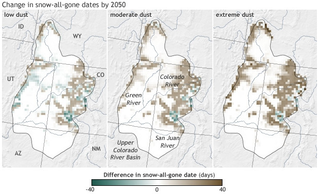
The maps at right suggest one strategy that water managers in the West could use to lessen the impacts of climate change: reduce blowing dust. Each image shows model projections of how much earlier in the spring the “snow-all-gone” day would arrive by 2050 compared to today based on the same amount of warming but different levels of dust. Positive days (brown) mean the snow disappears earlier in the spring.

The mountain snowpack in the Upper Colorado River Basin is a natural, frozen reservoir that melts its way into streams and rivers throughout late spring and early summer. Some years, huge amounts of dust blow in from the Southwest, dirtying the snow. The darker snow absorbs more sunlight and melts faster than normal. In those years, the spring thaw—marked by the arrival of the “snow-all-gone” date—can arrive more than a month earlier than normal.

If better soil conservation brought dust down to low levels (left-most map), models project that the average snow-all-gone date would increase by fewer than 20 days (lighter browns) for most of the area (this is for a relatively high greenhouse gas emissions scenario). In a few areas, snow might even linger a bit longer (green areas) than it currently does because models also project some localized increases in snowfall in high, cold terrain.

But regular occurrence of extreme dust levels (right-most map)—which researchers modeled after unprecedented dust conditions witnessed in 2009 and 2010—could lead to winter snows disappearing 40 or more days (darkest browns) earlier in the spring than they currently do. Given that the snow-all-gone date already arrives about three weeks earlier than it once did, the change would amount to a roughly nine-week advance in the snow-all-gone date.

The early disappearance of snow could further add to water supply problems in the already over-allocated river, especially in the Upper Colorado River Basin, which lacks the big reservoirs of the Lower Colorado. Earlier arrival of snow-all-gone dates also means a longer dry season, which would increase fire risk and stress aquatic ecosystems.

The Colorado River supplies water to an estimated 40 million people in the United States and Mexico, and it is already the focal point of heated water disputes among cities, farmers, ranchers, and agencies that protect wildlife. Presently, dust has a bigger impact on spring melt than warming. Climate change alone is likely to advance the snow-all-gone date in the Upper Colorado River Basin, but high levels of dust will only make the problem worse.

The new research identifies a risk to water supplies, but suggests an opportunity for adaptation. The high levels of dust blowing out of the Southwest are due to more than a century of inadequate soil conservation in the area’s dry, fragile soils. Restoring landscapes that have been damaged—by grazing, mining, energy exploration and development, farming, and off-road travel—to reduce blowing dust could keep a potentially manageable problem from turning into a major one.

HUD will provide $63 million to help our communities recover from floods #COflood

Meanwhile the Fort Collins Coloradoan (Sarah Jane Kyle) reports that there are snags in the distribution of recovery dough:

Throughout the fall, concerts, T-shirts and feel-good fundraisers championed the hundreds of flood survivors who were put out of their homes and away from their livelihoods. Donors were assured their dollars would make a difference in their lives.

Relief organizations say they’ll soon start using those dollars to get survivors…

The American Red Cross raised $6.3 million designated flood relief funds to put toward the organization’s anticipated $6.7 million cost of flood relief. The Long-Term Recovery Group, a collection of agencies with the United Way as a fiscal agent, has raised $921,750.41 as of Nov. 30. Catholic Charities expects to raise around $50,000 to help with flood-related needs.

Other agencies, such as Habitat for Humanity, have a small fund set aside in case a need arises. Loveland Habitat has about $500 in a fund so far but has not been actively fundraising, according to Executive Director Gwen Stephenson.

The dollars are allocated to various needs, including housing, item replacement and filling “unmet needs.” But most haven’t begun doling out dollars, and others are just beginning that process.

Drought news: South Platte and North Platte basins drought free, SE Colorado still hurting in areas #COdrought

US Drought Monitor December 5, 2013

Click here to go to the US Drought Monitor website. Here’s an excerpt:

The Central and Northern Plains and the Midwest

This area remained status quo for the week. Moderate to cool temperatures and areas of frozen soil led to no change in the drought depiction in the region.

The West

Abnormal Dryness (D0) expanded in the northern Cascade Mountains in Oregon and Washington as well as on the Oregon Coast. These areas have missed most of the recent precipitation that has fallen around the Northwest and have significant deficits for the year. The rest of the West remains unchanged this week.

Looking ahead

During the December 5-9, 2013 time period, precipitation is forecast along much of the eastern U.S., from the Southern Plains extending into New England. An above normal chance of precipitation is also present across areas of the West, particularly in the Southwest. Temperatures are expected to be below-normal across the country, with the exception of the East Coast during this time.

For the ensuing 5 days (December 10-14, 2013), the odds favor above-normal temperatures in the Southeast and in northern Alaska. Normal to below-normal temperatures are favored across the rest of the CONUS and in southern and central Alaska. Above normal-precipitation is likely across most of the eastern third of the country, in northern Alaska, and from the Pacific coast, through the Rockies and into the northern Plains. The eastern Southwest and the Central and Southern Plains, as well as the southwestern Midwest and southern Alaska are likely to see below-normal precipitation.

Republican River Basin: Arbiter Martha Pagel issues ruling on compliance pipeline

Republican River Basin

From the Yuma Pioneer (Tony Rayl) via the Imperial Republican:

Colorado and Nebraska entered into arbitration with Kansas earlier this year after Kansas’ representative on the Republican River Compact Administration voted against Colorado’s proposals on both issues.

The hearing was held before arbiter Martha Pagel earlier this fall, and Pagel issued separate rulings on both issues last Wednesday, November 27. In essence, Pagel ruled Colorado is taking the proper steps, but that Kansas remains “reasonable” in its objections.

“Although the Arbitrator found that Colorado’s revised Compact Compliance Pipeline (CCP) proposal had made significant progress in addressing unresolved issues from the prior arbitration proceeding, and that Colorado had offered a reasonable and persuasive proposal for modifying inputs to the Groundwater Model, the district is disappointed that Arbiter Pagel was not able to provide Colorado with any relief from the obstructionist behavior of Kansas officials,” stated the Republican River Water Conservation District in a statement issued by its legal representative, Peter Ampe of Hill & Robbins. Continue reading “Republican River Basin: Arbiter Martha Pagel issues ruling on compliance pipeline”

‘Groundwater will be a part of the state water plan’ John Stulp #COWaterPlan

Colorado Water Plan website screen shot November 1, 2013

From The Pueblo Chieftain (Chris Woodka):

Call it a wet-headed stepchild. Colorado has puzzled for years about how to account for its underground water resources, with about the same impact as water sloshing in the bottom of a precariously carried bucket. A state water plan will attempt to incorporate groundwater management, including possible aquifer storage, even though the relationship between surface water and well water is not fully understood.

“Groundwater will be a part of the state water plan,” John Stulp, the governor’s water adviser, told about 80 attendees of a groundwater conference this week. “There are a number of studies and plans that will go forward as the state water plan is developed.”

The conference, organized by the American Groundwater Trust, was designed to address policy as a follow-up to more technical reports generated from a 2012 conference.

While Colorado water rights stretch back to the mid-1800s, groundwater in the state was of little concern until more high-capacity wells were drilled in the 1950s and 1960s. It wasn’t until 1969 that well use was incorporated into the elaborate web of prior appropriation water right, explained Steve Sims, a water lawyer who once defended the state’s water rights in the attorney general’s office. But since then, a tug-of-war between the General Assembly and water courts has muddied how groundwater is treated. Non-tributary wells are regulated by a separate commission.

“What we got was a hodgepodge of rules,” Sims said. “It’s been driven by real estate developers.”

Key court cases eroded the jurisdiction of water courts themselves as well as the power of the state engineer to regulate wells, he said. The Empire Lodge case triggered a legislative fix to substitute water supply plans in 2002. The 2009 Vance case changed the way the state accounts for water produced by oil and gas drilling.

Geography also plays a part. Alluvial well regulations differ in all of the state’s major river basins, as well as in non-tributary basins. There is little scientific understanding of the relationship of groundwater levels to surface flows, other than the common wisdom that surface irrigation or flooding increase the levels, while pumping and drought decrease them. But the timing of return flows, availability of underground storage sites and long-term effects of pumping are still unknown.

“It’s not a precise science,” said Reagan Waskom of the Colorado Water Institute, which is completing a study of the South Platte basin mandated by the state Legislature in 2012. “If you had a valve and could put water back into the river when you need it, it would be great.”

More Colorado Water Plan coverage here.