Denver Water CEO earns prestigious Aspinall Award

Jim Lochhead -- photo via Westword (Alan Prendergast)
Jim Lochhead — photo via Westword (Alan Prendergast)

Here’s the release from Denver Water (Stacy Chesney):

The Colorado Water Congress awarded Jim Lochhead, Denver Water CEO/manager, the 2014 Wayne N. Aspinall “Water Leader of the Year” Award.

The Aspinall Award is given for a career of service and contribution to the water community. It is awarded to a person who has dedicated a significant part of his or her career to the advancement of the state and its programs that define the process of protecting, developing and preserving the state’s water resources.

A true statesman, Lochhead has navigated his 30-year career in the water industry by developing trust and confidence with interests throughout Colorado and the West. This characteristic ensured his leadership in the recent accomplishment of the Colorado River Cooperative Agreement which changes the way diverse interest groups cohesively manage, protect and preserve water in Colorado. Described by many as a genuine and sincere person, Lochhead has deep experience and expertise in Colorado water issues and the political process. In addition to championing regional cooperation in the water industry, Lochhead now oversees the supply of water to the 1.3 million people Denver Water serves.

Lochhead was nominated and selected for the award by the previous Aspinall Award winners and a group of Colorado Water Congress officers. Eric Wilkinson, 2011 Aspinall Award recipient, said: “Jim is very deserving of the Aspinall ‘Water Leader of the Year’ Award as he epitomizes the true intent of the award. He is a recognized and respected leader in the water community, not only in Colorado but throughout the Colorado River Basin and the West. Colorado is indebted to Jim for his exemplary service and innumerable contributions to the Colorado Water community.”

About Jim Lochhead

Jim Lochhead was appointed Denver Water’s CEO/manager in 2010. He serves on the boards of Association of Municipal Water Agencies, Water Research Foundation, Western Urban Water Coalition, Water Utility Climate Alliance, Denver Metro Chamber of Commerce and the Metro Denver Economic Development Council. He is on the Advisory Board of The Dividing the Waters Program at the National Judicial College. Prior to joining Denver Water, Lochhead was a shareholder at Brownstein Hyatt Farber Schreck, LLP. He served as executive director of the Colorado Department of Natural Resources from 1994 to 1998.

About the Aspinall Award

CWC presents the prestigious Wayne N. Aspinall “Water Leader of the Year” Award annually to an individual Coloradan who has long demonstrated courage, dedication, knowledge and strong leadership in the development, protection and preservation of Colorado water- those attributes possessed by Wayne N. Aspinall. The late Aspinall, a lawyer and former member of the U.S. House of Representatives, remains one of the most influential water leaders in Colorado history.

More Denver Water coverage here.

The downside of a Twitter fest: You were out of line Wockner #COWaterPlatform

I’m really uncomfortable writing this post in a public forum, but Gary Wockner chose a public forum…

Today Gary Wockner retweeted one of my Tweets from the Colorado Water Congress’ Annual Convention. The Twitter UI allows you to edit the retweet.

Gary Wockner called Brian Werner a liar in the retweet. That was out of line.

First, he should clarify his charge. He is wrong about Brian being a liar.

Second, he should of used his own website — bare ass and all — or his own Twitter feed, and not piggybacked on mine. Brian Werner is my colleague and my friend. Anyone reading the Tweet could easily think that I typed the word liar and I would never characterize Brian in that way.

Here’s the offensive retweet:

Gary Wockner calling Brian Werner a liar piggybacking on @CoyoteGulch

I wish Gary hadn’t chosen such a public place to vent. I believe that he lives in a world without context.

Drought news #COdrought

US Drought Monitor January 28, 2014

Click here to go to the US Drought Monitor website. Here’s an excerpt:

California

Drought and relatively mild temperatures continue to prevail across the state. In the northwestern part of California, a 1-category degradation from severe to extreme drought (D2 to D3) was made across Humboldt and Trinity Counties. The Central Sierra Snow Lab near the Donner Summit reports 8 inches of snow on the ground, the lowest for this time in January since at least 1946. In the general vicinity of Monterey to Bakersfield, conditions warranted a 1-category downgrade, from extreme to exceptional drought (D3 to D4). A few of the impacts within the D4 area include fallowing of land, wells running dry, municipalities considering drilling deeper wells, and little to no rangeland grasses for cattle to graze on, prompting significant livestock sell off…

Southern and Central Plains

In Texas, much of the eastern Panhandle has received 25 percent or less of normal precipitation in the past 60-days, with some locales in the lowest 5 percent (AHPS). This sizable area of lowest quartile PNP’s extends into western Oklahoma. PNP’s within the second quartile (25-50 percent of normal) are widespread across much of Oklahoma and southeastern Texas. Thus far this month in Oklahoma, Lawton and Frederick have not received any precipitation, and Clinton has received only a trace of precipitation. Subzero dew points have occurred throughout much of January. As a result, 1-category degradations were made within these areas. In northwest Kansas, near the town of Colby, strong winds and blowing dust are being blamed for an 11-car pileup, which resulted in 3 fatalities…

Southwest

In Arizona, another week passed without precipitation. The last measurable precipitation in Flagstaff fell just before Christmas (December 20th). A predominantly dry pattern has been in place since the very beneficial and welcome late-season monsoon rains last September. Impacts are somewhat limited at this time due to lower ET rates during winter, but an increased snowpack in the next two months is needed to preclude more serious problems. SNOTEL Snow Water Equivalent (SWE), as of January 29, 2014, is mostly well below normal across the Mogollon Rim area (ranging from 18-44 percent), and in the White Mountains of eastern Arizona (SWE 27-40 percent of normal). As a result, a 1-category downgrade was made for both areas. In northern New Mexico’s Sangre de Cristo Mountains, SWE’s range from about 56-62 percent of normal. The last significant snowfall event for this region occurred from November 21-24, 2013, when about a foot of snow fell. Continued dryness since that time and fairly low SWE’s prompted a one-category downgrade across much of northern New Mexico up to the D3 designation.

In southwestern Colorado, with declining SNOTEL precipitation percentiles and snowpack percent of normal values, a 1-category downgrade (from no dryness to D0) was rendered to the drought depiction. In northeastern Colorado, a 1-category downgrade (from no dryness to D0) was made over southern Logan County, Washington County, and northern Lincoln County. In northeastern Colorado, the Standardized Precipitation Indices (SPIs) for the past 30 days (0 to -1.0) and 90 days (0 to -2.0) also support these alterations to the depiction. In addition to below-average precipitation from much of November through the present time, high winds have prevailed. There were reports of dry topsoil and blowing dust in Washington County, though some of this is due to management of fields…

Looking Ahead

During January 30-February 3, 2014, locally heavy precipitation amounts (2.5-3.5 inches, liquid equivalent) are expected for the higher elevations of the Cascades, the Sierras, the Bitterroots, the Wasatch, and the Colorado Front Range, which should help to elevate the SWE’s in those areas. Moderate precipitation (0.5-1.5 inches) is predicted across the abnormally dry regions of the central Gulf Coast and lower Mississippi Valley, as well as parts of south-central Florida. Elsewhere, precipitation amounts of less than a half-inch are generally forecast.

For the ensuing 5-day period, February 4-8, 2014, there are elevated odds of above-median precipitation over much of the nation east of the Continental Divide, except for portions of the upper Mississippi Valley and northern Plains, where odds favor below-median precipitation. Below-median precipitation is also favored for California, southern Arizona, and most of Alaska.

Colorado State University researchers receive $2.2 million for efforts to improve water quality

Blue-Green algae bloom

Here’s the release from the Environmental Protection Agency:

Today at the 14th National Conference and Global Forum on Science, Policy and the Environment in Washington, D.C., U.S. Environmental Protection Agency (EPA) Administrator Gina McCarthy announced a grant of $2.2 million to the Center for Comprehensive, OptimaL and Effective Abatement of Nutrients (CLEAN) at Colorado State University to demonstrate sustainable solutions for reduction of nutrient pollution in the nation’s waterways.

Colorado State University is among four research institutions receiving a total of $9 million in EPA Science to Achieve Results (STAR) grants to advance innovative and sustainable water research to manage harmful nutrient pollution. Nutrient pollution is one of America’s most widespread, costly and challenging environmental problems, and is caused by excess nitrogen and phosphorus in waterways.

The mission of Colorado State University’s CLEAN Center is to create knowledge, build capacity, and forge collaboration to develop and demonstrate sustainable solutions for reduction of nutrient pollution in the nation’s water resources. Colorado State University researchers will use the EPA grant to lead a multi-stakeholder effort to study and control the sources of excess nutrients in wastewater, stormwater, agricultural water, and natural systems. Key areas of research include: wastewater treatment technologies; water reuse systems; urban stormwater management; agricultural conservation; socioeconomic incentives; nutrient trading; and water rights.

“These grants will go towards research to help us better manage nutrients and better protect our precious water resources from the dangers of nutrient pollution, especially in a changing climate,” said Administrator McCarthy.

When excessive nitrogen and phosphorus enter our waterways — usually via stormwater runoff and industrial activities — our water can become polluted. Nutrient pollution has impacted many streams, rivers, lakes, bays and coastal waters for the past several decades, resulting in serious environmental and health issues, and negatively impacting the economy. For example, nutrient pollution can reduce oxygen levels in water, leading to illnesses in fish and the death of large numbers of fish. In some cases nutrient pollution leads to elevated toxins and bacterial growth in waters that can make people sick.

The Science to Achieve Results (STAR) grants announced by Administrator McCarthy are an integral part of EPA’s research on water quality and availability. Improving existing water infrastructure is costly, which makes creating new and sustainable approaches to water use, reuse and nutrient management important.

These grants support sustainable water research and demonstration projects consistent with a comprehensive strategy for managing nutrients and active community engagement throughout the research process.

In addition to Colorado State University, the following institutions received grants:

· Pennsylvania State University Center for Integrated Multi-scale Nutrient Pollution Solutions, to focus on nutrient flows in Pennsylvania and the Chesapeake basin

· University of South Florida Center for Reinventing Aging Infrastructure for Nutrient Management, to support Tampa Bay and similar coastal areas as they face problems of aging wastewater collection and treatment systems, and rapid population growth

· Water Environment Research Foundation, Alexandria, Va., National Center for Resource Recovery and Nutrient Management, for innovative research in nutrient reduction through resource recovery and behavioral factors affecting acceptance and implementation.

For more information on Colorado State University’s CLEAN Center, visit: http://www.engr.colostate.edu/ce/

For more information on the grants and projects, visit: http://epa.gov/ncer/nutrient

For more information on EPA-funded research supporting water quality and availability, visit: http://www.epa.gov/research/waterscience

More water pollution coverage here.

‘I’m looking at the #COWaterPlan as a road map for an uncertain future’ — April Montgomery #COWaterPlatform

Colorado Water Plan website screen shot November 1, 2013

From The Durango Herald (Joe Hanel):

Gov. John Hickenlooper’s call to develop a state water plan is the talk of the Colorado Water Congress’ annual convention this week, as people try to figure out what it is and whether it will be an aid or a threat. The plan has not been written, and no one is quite sure what it will be.

“I’m looking at the Colorado Water Plan as a road map for an uncertain future,” said April Montgomery of Telluride, who represents Southwest Colorado on a statewide water committee.

Montgomery spoke at a panel discussion Thursday at the Water Congress convention…

A bipartisan group of legislators, led by Sen. Ellen Roberts, R-Durango, is irked that Hickenlooper seemed to bypass the Legislature. Roberts is sponsoring a bill to require public hearings and legislative approval before the water plan can be implemented. Water is the state’s most critical resource, she said.

“It built our state, and it will be critical to building our state,” Roberts said. “For something that’s the No. 1 resource in our state, the Legislature has a place at the table.”

Roberts had a “very spirited discussion” Wednesday with Mike King, who serves in the governor’s Cabinet as director of the Department of Natural Resources, King told the crowd of around 300 at the Water Congress convention.

“Senator Roberts, for those of you who don’t know, is one of the good ones,” King said. “So when Senator Roberts expresses concerns about where we’re headed, I take that very seriously.”

The final plan will, “of course,” need approval by the Legislature, King said…

Coloradans have fought an East-West water war throughout state history, as the drier Front Range looked to Western Slope rivers to supply its cities and farms.

The fighting subsided the last eight years as the state tried out a new idea to create “roundtables” in every major river basin, along with a statewide group known as the Interbasin Compact Committee. Those groups have focused on building trust among the basins and assessing the water needs of every place in the state, from Arkansas Valley farms to Four Corners river rafters.

But after Hickenlooper put out his order for a water plan, several of the roundtables took tough stances on what should be in the plan. The Colorado River Roundtable put out a white paper that essentially said all the water in the river is spoken for, and there’s no way to pipe more water east to the Front Range.

Patricia Wells, general counsel for Denver Water, said she thinks the dueling white papers risk bringing Washington-style gridlock to Colorado’s water community.

She urged water experts from around the state to refrain from “demonizing or trivializing” each other’s water needs…

Montgomery, who represents Southwest Colorado on the Interbasin Compact Committee, said people need to think of their local communities, but also the state as a whole.

“A strong Denver helps the Southwest, as well as a strong recreational economy on the Western Slope, that’s going to help the Front Range,” Montgomery said.

From Aspen Public Radio (Marci Krivonen):

As the state prepares a statewide water plan, a local non profit wants to make sure our rivers and streams in the Valley are protected. Basalt-based Roaring Fork Conservancy is pinpointing environmental values, so, as the state searches for more water to fill growing needs, local waterways stay full…

“I think our role is kind of two-fold,” says Heather Tattersall.

She’s the Watershed Action Coordinator at the Roaring Fork Conservancy. The non profit is part of an advisory group looking into non-consumptive uses of local rivers, like fishing and rafting. Their research could become part of the statewide water plan.

“It’s looking at pieces so that, if or when water’s reallocated we don’t injure areas that are healthy right now and we don’t deteriorate areas that are already struggling,” Tattersall says.

So, if the state decides to pull more water from the Colorado River Basin to meet future demands, Tattersall says certain areas of the Roaring Fork Watershed, which feeds the Colorado, should be protected, like the lower Crystal River.

“There’s an in-stream flow right on the Crystal of 100 CFS (cubic feet per second). In low water years, that was down to two CFS. That can sort of be a red flag as a place to pay attention to. I think making sure that the places that are important to us, that we know about, that we’re able to use the knowledge we have and information and research we’ve gained, that we’re able to share that so that we’re getting adequate water and flows to protect the needs we have.”

The Conservancy’s efforts will be included in a larger plan that looks at the Colorado River Basin. It’s one of nine basins looking at what their needs are and formulating plans that will become part of the statewide water plan. Jim Pokrandt is with the Colorado River Water Conservation District, which aims to protect the Colorado from overuse.

“We know the Colorado River Basin, and all of Western Colorado, is the target for helping the Front Range fill its gaps,” he says.

Indeed, the biggest need for additional water will happen in the South Platte Basin, the most populous region of the state and an area that needs plenty of water for agriculture. Pokrandt says most of the state’s water is on the West Slope.

“It’s the belief of many on the Front Range that the Colorado River system is going to be part of their salvation. We’re not so sure over here on the West Slope. So, our version of the Colorado Water Plan will be keenly looking at that issue.”

The Colorado River basin is already stretched, says Pokrandt, diverting water to Front Range cities, as well as sending water to downstream states and Mexico.

More Colorado Water Plan coverage here.

Colorado Water Congress Annual Convention: ‘We’re [Arkansas Basin] hoping for a better 2014’ — Steve Witte

US Drought Monitor for Colorado January 28, 2014

From The Pueblo Chieftain (Chris Woodka):

Unless water conditions improve significantly this spring, farmers in the Lower Arkansas Valley could see a fourth year of reduced water supply. The low point so far was 2013, where many wells were cut off completely, and overall pumping was the lowest on record. Surface irrigators also dealt with reduced flows until the end of the growing season and large fires damaged several watersheds.

“We’re hoping for a better 2014,” Water Division 2 Engineer Steve Witte told the Colorado Water Congress this week. “But I don’t know if I have reason to be optimistic.”

While not as dry as 2012, the second driest on record, the water available in 2013 dropped to the fourth lowest amount ever, as measured at multiple locations, Witte said.

The convention wraps up today with the Aspinall award luncheon.

It was a veritable Twitter-fest yesterday during the sessions. You can follow the action with the hash tag #COWaterPlatform. I’ll be live-Tweeting @CoyoteGulch.

The Colorado Water Congress Annual Convention continues today #COWaterPlatform

I’ll be live-Tweeting the goings on at @CoyoteGulch using hash tag #COWaterPlatform.

Weekly Climate, Water and Drought Assessment of the Upper #ColoradoRiver Basin

Upper Colorado River Basin month to date precipitation thru January 26, 2014

Click here to read the current summary. Click here to go to the NIDIS website hosted by the Colorado Climate Center.

More Colorado River Basin coverage here.

Climate change planning in Colorado necessarily incorporates the uncertainty of forecasting

Turn up the heat slowly via the Sierra Club

From Climate Central (Bobby Magill):

Changes in snowfall and snowpack melt patterns as temperatures rise could threaten the water supplies of numerous Southwestern cities that depend on the Colorado River for drinking water. Extreme weather and greater exposure to hurricane storm surge could become a regular threat to New York City and the New Jersey coastline, which are still recovering from Hurricane Sandy…

Colorado symbolizes how attitudes about managing the risks posed by climate change are different in parts of the West. Cities along Colorado’s Front Range urban corridor have drafted climate change action plans and the state has conducted studies analyzing climate change’s possible impacts in detail.

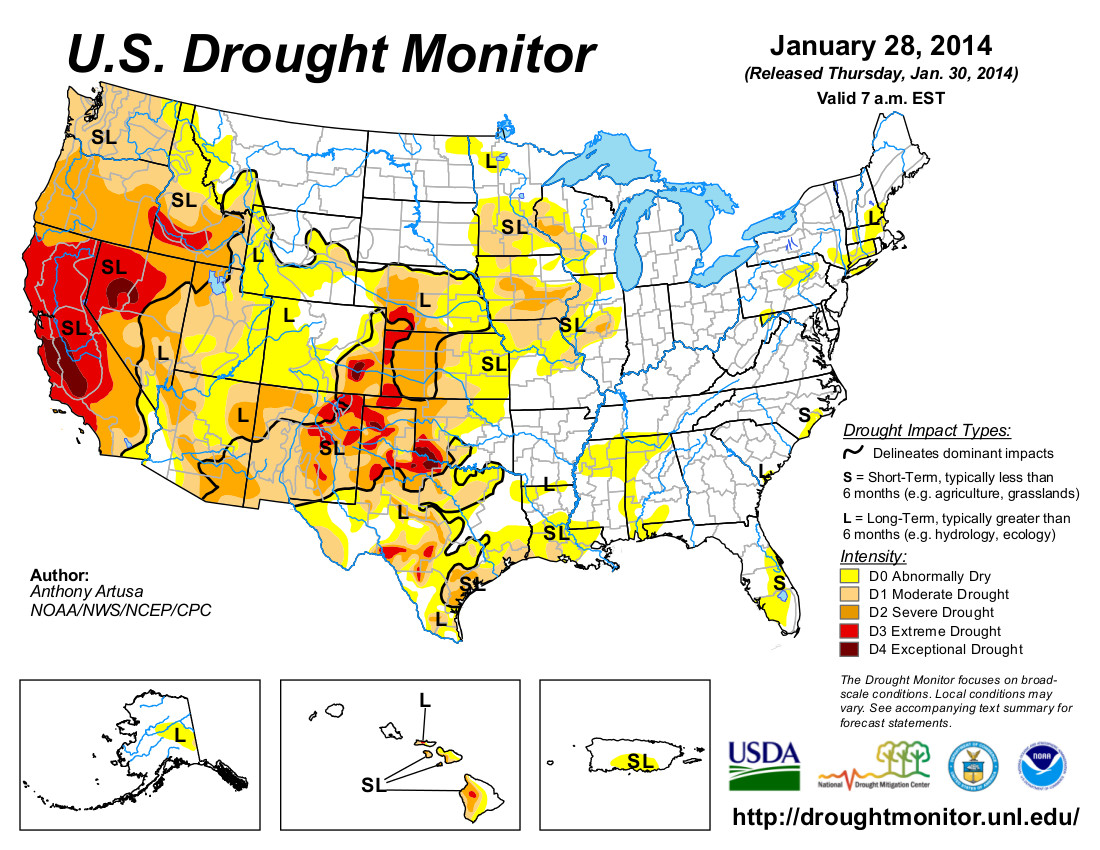
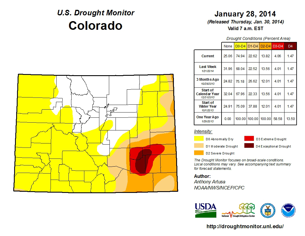
But like many states across the country, progress is hampered by uncertainty in how climate change will affect Colorado even as its recent disasters serve as a reminder of how vulnerable the state is.

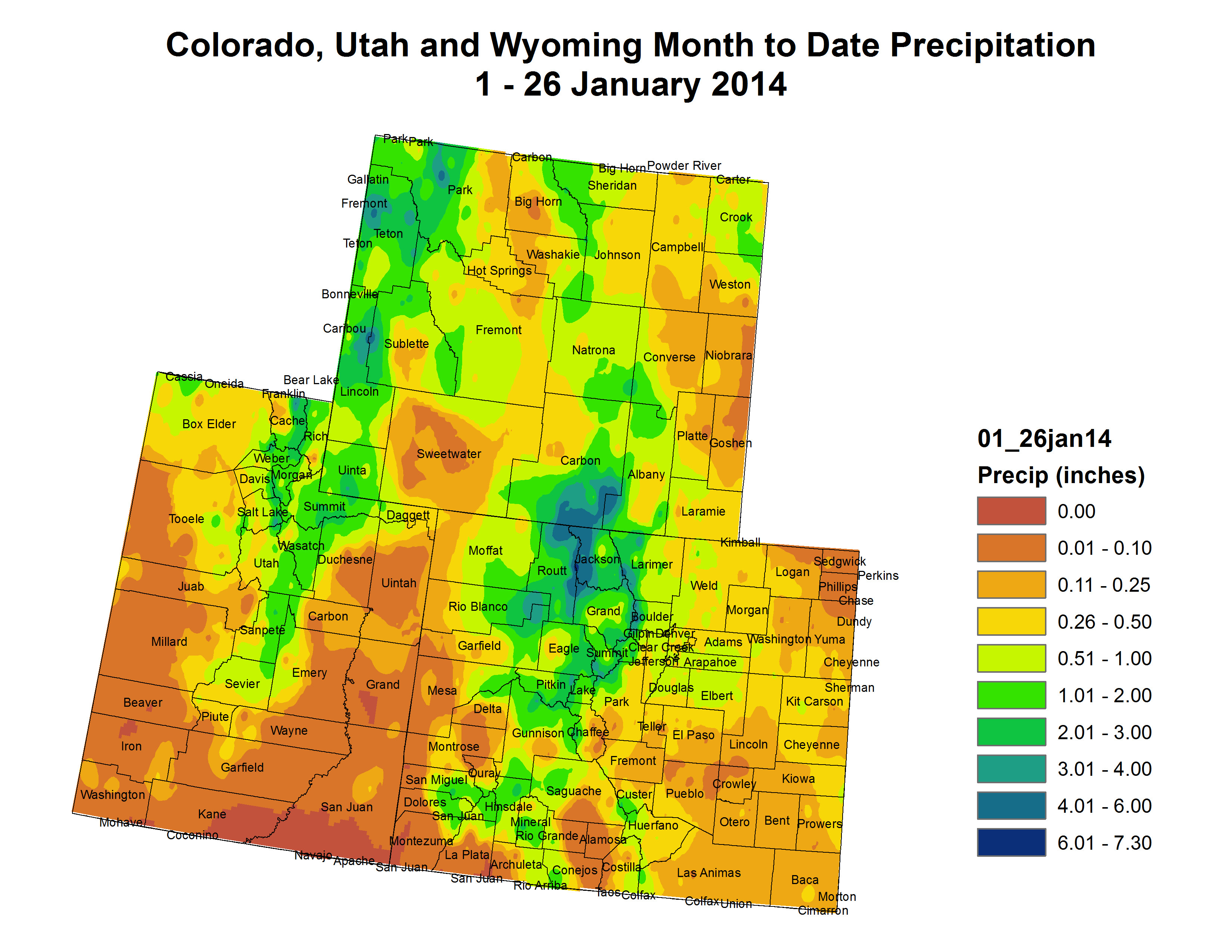
Nobody knows for sure if Colorado will be wetter or drier in a warming world, and that has huge implications for urban growth along the Front Range and whether water-thirsty agriculture can be sustained in a state that is expected to grow by 50 percent to 8 million by 2040. What is certain is that Colorado will be warmer in the future, potentially creating drought conditions even if the state gets the same average rain and snow as it does today.

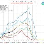
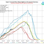
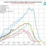
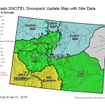
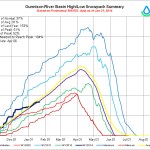
Studies show that Colorado will see average annual temperatures increase by 2.5°F, with summers warming by 5°F and winters by 3°F by 2050. Warmer temperatures mean changes in evaporation and soil moisture, reducing snowmelt runoff in each of Colorado’s river basins. More precipitation is expected to fall as rain rather than snow, and the state’s high-elevation snowpack — the source of much of the state’s water supply — could decline by 20 percent and melt earlier than in the past.

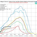
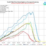
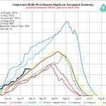
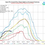
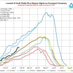
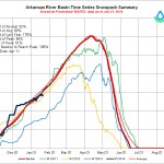
By 2070, the spring snowmelt runoff could begin up to 17 days earlier than today, while one of Denver’s most significant sources of water, the South Platte River, could see a decline in streamflow by up to 35 percent, according to the 2012 Joint Front Range Climate Vulnerability Study, which examined how streamflows in three of the state’s largest river basins will be affected in different climate change scenarios.

“Residential development for millions of additional people here will require a lot of water, yet water is already oversubscribed and 83 percent of our water is currently used for agriculture,” said Colorado State University atmospheric scientist Scott Denning. “As the climate warms, more water will evaporate and sublimate from mountain snowpacks before it ever reaches reservoirs, and agricultural demand will rise.”

That means there will be less water go to around as an ever-rising population conflicts with a decreasing water supply…

Local officials aren’t always up to date on the science of climate change, but they’re aware of water supply and demand, the stresses put on both and what that could mean for them, Denning said.

“What a lot of people don’t seem to ‘get’ is that drought is a running sum of evaporation minus precipitation, so increasing evaporation from warmer air leads to more drought even if precipitation stays the same,” he said. “There’s really nothing local governments can do to change future climate, but they must prepare for a much tighter water supply, for more frequent wildfire and occasional floods. This is common sense and not really new, but it is urgent.”[…]

And later this year, Colorado’s most comprehensive assessment of how climate change will impact the state and its drastically varied landscape will be published. The project is a joint Colorado State University and University of Colorado-Boulder study called the Colorado Climate Change Vulnerability Study, said its co-author, Eric Gordon, director of the Western Water Assessment at the National Oceanic and Atmospheric Administration Earth System Research Laboratory in Boulder.

There is a sense in Colorado that the high level of uncertainty about how climate change will affect the state and its water supply is a major hurdle to preparing for it.

“My sense is we’re somewhere in the middle of the pack (of the states preparing for climate change adaptation), but we’re highly sensitized by recent drought and flood,” said Reagan Waskom, director of the Colorado Water Institute at Colorado State University. “Climate change attribution is difficult, but the citizenry gets that it’s different — warmer temperatures and more extreme events.”[…]

Even though cities such as Denver and Fort Collins began drawing up plans to deal with climate change as early as 2007, the level of preparation and recognition of the threat climate change poses varies, Waskom said.

“It’s a mixed bag,” he said. “The challenge is not knowing what they’re planning for. We’re planning for an unknown future.”

Cities don’t know if they need to prepare for more frequent extreme weather events or an increase in average temperatures or precipitation — or both, he said.

“In the past, water utilities could look at past hydrology and weather patterns and relatively confidently know how to plan for the future,” Kaatz said.

Now, she said, utilities have to factor in timing of snowmelt, extreme weather events, the lifespan of the winter snowpack, changes in vegetation in watersheds, water evaporation and many other changes expected to be brought about by climate change.

“Another concern is that we can’t know the exact changes and timing of those changes in our region in the future,” Kaatz said. “The range of climate projections for Colorado is immense, showing the potential for not only varying amounts of warming, but also both wetter and drier conditions. This is different than what is projected for other regions in the southwest United States.”

Some Front Range cities have already begun to tackle “resiliency” to extreme weather regardless whether it is caused by climate change or anything else, said Lucinda Smith, environmental services director for the city of Fort Collins, whose mayor, Karen Weitkunat, was named in December as one of 16 local city officials from across the country to sit on the White House Task Force on Climate Preparedness and Resilience…

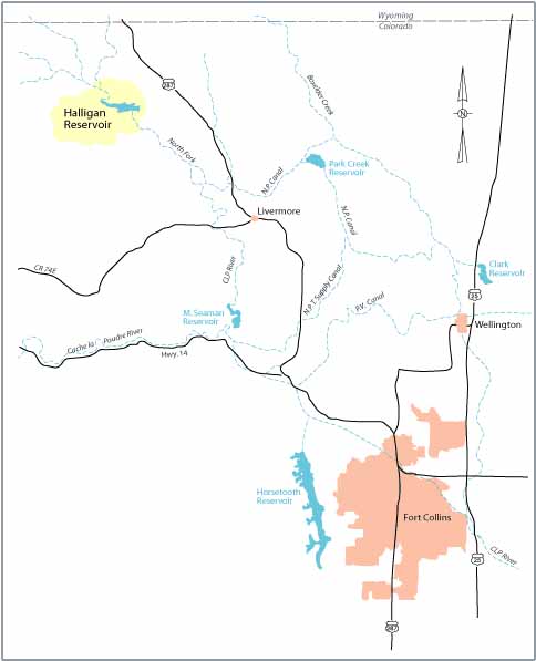
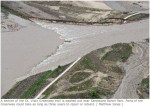
Some water suppliers, including the Northern Colorado Water Conservancy District, which provides supplemental water to cities and farmers north of Denver, believe that adapting to climate change means building new reservoirs. The district, known as Northern Water, has proposed building a large new reservoir north of Fort Collins, which would siphon high flows off the Cache la Poudre River during spring snowmelt season and store that water for future use.

But responding to climate change by building new reservoirs designed to capture water from snow that is expected to melt earlier and faster than ever before is creating a philosophical battle between those who want to build more reservoirs to shore up Colorado’s water supply and enivonrmentalists who are encouraging cutbacks in water use and taking water from agriculture as a way to achieve the same goal while preserving wildlife habitat.

Conservation groups in Colorado worry that Northern Water’s proposed new reservoir, part of the proposed Northern Integrated Supply Project, will destroy wildlife habitat in the river, which creates a wild ribbon of greenspace through the city of Fort Collins downstream of where water would be siphoned away for the new reservoir.

“Given the implications of climate change (wetter wets, drier drys), additional storage to capture the water when it is available is essential,” Northern Water General Manager Eric Wilkinson said, adding that both new reservoirs and water conservation are necessary to shore up the region’s water supply in a changing climate.

Laurna Kaatz, an environmental scientist and staff climate change expert at Denver Water, a regional water utility that collaborated with Northern Water, Fort Collins and other Front Range cities in the Joint Front Range Climate Vulnerability Study, said Denver Water is also looking for new water storage, and has plans to expand one of its major reservoirs.

Denning said another solution is for water to come from agriculture rather than expecting the state to sustain Colorado’s largest water consumer.

“In the West we say that water flows uphill toward money,” he said. “I expect that the only way to provide water for a 50 percent increase in urban populations will be for cities to buy enormous amounts of agricultural water rights. This will result in a drastic and permanent transformation of rural life as water is diverted from marginally productive farms and ranches to rapidly growing cities along the urban Front Range corridor.”

CWCB finds that Pitkin County’s proposed RICD meets requirements to go forward

Roaring Fork River in winter

From the Aspen Daily News (Brent Gardner-Smith):

The CWCB is required by state law to determine if a proposed recreational in-channel diversion, or “RICD,” meets certain requirements. Having found that the county’s proposed water right for the Basalt kayak park passes the test, its written finding will now be sent to District 5 water court, which is reviewing the county’s water right application.

If the water court ultimately issues a decree for the new in-channel water right, it will form the basis of what will be known as the “Pitkin County River Park.”

The kayak park will include two surf waves created by placing two rock structures in the Roaring Fork River. The waves are designed to be accessible for beginner and intermediate kayakers, and would be rated at “green” and “blue” levels of difficulty, akin to the rating of ski trails.

The section of river is just below the Basalt bypass bridge on Highway 82 and above the confluence of the Roaring Fork and the Fryingpan rivers near downtown Basalt…

If the water right is decreed as presently configured, it would allow the county to call for differing levels of water to be sent down the Roaring Fork River to the Basalt kayak park.

From April 15 to May 17, the county could call for 240 cubic feet per second (cfs) of water to flow through the park. By comparison, the Roaring Fork River below Maroon Creek has been flowing at about 100 cfs in January.

Then, from May 18 to June 10, the county could call for 380 cfs. And during peak runoff, from June 11 to June 25, it could call for 1,350 cfs of water to flow through the kayak park and create the biggest surf waves of the season.

After June 25, the water right steps back down to 380 cfs until Aug. 20, and then back to 240 cfs until Labor Day…

The new water right would be “non-consumptive,” meaning the water would stay in the river and not be diverted for a “consumptive” use, such as irrigation.

The county applied for the new water right in water court in December 2010. If it is approved, the water right would have an appropriation date of 2010, making it a “junior” water right, compared to “senior” water rights dating back to the early 1900s or late 1880s, as many water rights in the region do.

As part of the water court process, the county has negotiated settlement agreements with over a dozen other water rights holders in the Roaring Fork River basin. As such, the scope of the county’s proposed water right has been narrowed.

For example, the length of the season when the new water right would be in effect was reduced by 25 days to a period between April 15 and Labor Day, and the county can only call for water from upstream junior water rights holders to flow through the park during daylight hours.

And the county agreed to a “carve out” provision that allows up to 3,000 acre-feet of new water rights to be developed upstream of the kayak park over the next 15 years, without being subject to the local government’s new water right.

Those provisions, and others, were enough to convince the CWCB board on Monday to rule in favor of the in-channel diversion water right.

There is, however, still one party objecting to the water right in state water court, the Twin Lakes Reservoir and Canal Co.

Twin Lakes diverts about 50,000 acre-feet of water each year off the top of the Roaring Fork river basin, primarily for municipal use in Colorado Springs, Pueblo, Pueblo West and Aurora.

Twin Lakes is concerned the water right for the kayak park will limit its ability to develop other new water rights in the Roaring Fork River basin in the future.

However, at the CWCB meeting, the water attorney for Twin Lakes sounded OK with new language approved by the board that was designed to address Twin Lakes’ concerns.

“It sounded positive,” [Pitkin County Attorney John Ely] said of Twin Lakes’ evolving position. “They have to go back to their board, and so, we’ll see.”

More whitewater coverage here.

Heavy snow and strong winds expected across the North Central Mountains tonight through Friday morning #COwx

HB14-1026: ‘In the form it’s in, this bill isn’t the way to do it’ — Jay Winner #COleg

Straight line diagram of the Lower Arkansas Valley ditches via Headwaters

From The Pueblo Chieftain (Chris Woodka):

A bill that would create a new class of water rights called flex marketing was given the blessing of the state House agriculture committee Monday on a 10-3 vote. Supporters say it allows water to stay in the hands of farmers, while increasing potential uses. Opponents say it could be a “Trojan horse” for cities to take more farm water.

Opposing the bill was state Rep. Leroy Garcia, D-Pueblo, joined by Republicans Don Coram of Montrose and Ray Scott of Grand Junction.

“I think that based on what I was hearing in the committee, and from people in my district, that this bill is not in the best interests of the Arkansas Valley,” Garcia said.

The bill, [HB14-1026], is backed by Aurora and other interests in the South Platte River basin as a way to allow transfers of agricultural water that do not require complete dry-up of farmland. It would allow consumptive use to be transferred in exchange for fallowing land or reduced irrigation.

After the bill was amended to allow projects to circle back to water court if other water rights were injured, return flow issues and a basin-of-origin provision was added, the bill got the support of the Colorado Water Congress state affairs committee.

The bill also interests the Pueblo Board of Water Works, which could use it to enhance its shares of the Bessemer Ditch.

“The amendments satisfied most of the objections of committee members,” said Paul Fanning, water board spokesman and a member of the CWC state affairs committee.

Opponents of the bill, including The Pueblo Chieftain editorial board, say that it amounts to an end-run around the anti-speculation doctrine of state water law. There also are concerns that the new flex water right would facilitate permanent dry-ups.

Lower Arkansas Valley Water Conservancy District’s attorney Peter Nichols told the House committee the bill needs more controls in order to avoid speculation.

“Our big fear is that this could be a Trojan horse for municipalities to come in and take water from farms,” said Jay Winner, general manager of the Lower Ark district.

The district will ask the sponsor, state Rep. Randy Fischer, who chairs the ag committee, to amend it in order to prevent speculation.

“Farmers need tools like this if alternative transfer methods like the Super Ditch are going to be successful,” Winner added. “In the form it’s in, this bill isn’t the way to do it.”

While other amendments still could be added to the bill, Garcia said he ultimately will not support it.

“I don’t think the bill is going to change enough,” Garcia said. “It does little to protect existing water rights.”

Here’s the summary of the bill from the Colorado Water Congress website:

Under the anti-speculation doctrine, current water court proceedings governing an application to change the beneficial use of an irrigation water right require the applicant to designate a specific alternative beneficial use identified at the time of the application. The bill creates a more flexible change-in-use system by allowing an applicant who seeks to implement fallowing, regulated deficit irrigation, reduced consumptive use cropping, or other alternatives to the permanent dry-up of irrigated lands to apply for a change in use to any beneficial use, without designating the specific beneficial use to which the water will be applied. Section 1 of the bill defines “flex use” to mean an application of the fully consumptive portion of water that has been subject to a water right change-in-use proceeding to any beneficial use. It also redefines “appropriation” to exclude flex use from the anti-speculation doctrine. Sections 2 and 3 describe the procedures for obtaining a flex use change-in-use decree and a flex use substitute water supply plan.

Status
01/08/2014 Introduced In House – Assigned to Agriculture, Livestock, & Natural Resources
01/27/2014 House Committee on Agriculture, Livestock, & Natural Resources Refer Amended to House Committee of the Whole

More 2014 Colorado legislation coverage here.

Snowpack news (% of avg): Rio Grande = 67%, South Platte = 109%, Upper Colorado River = 107%

Mage at the NRCS was busy yesterday. Click on a thumbnail to view the gallery of snowpack data.

From The Denver Post (Scott Willoughby):

With another powder day looming on Interstate 70, Denver skiers commuting up to the mountains already know there’s snow in the high country. Just how much depends on where you go.

According to Natural Resources Conservation Services Snotel measurements, the statewide snowpack for Colorado was at 94 percent of average Tuesday, a little less than snowbound Front Range skiers might think. That’s because the vast majority of snow has fallen north of I-70, if you include the entirety of the sprawling South Platte River basin measuring at 109 percent of its annual average snowpack.

The North Platte basin to its west leads the state at 110 percent, followed by the adjacent Yampa/White River basin (home to Steamboat Springs) at 108 percent, while the Colorado River basin — home to the Summit County ski resorts, Winter Park, Vail and Beaver Creek, among others — measures at an impressive 107 percent of average (and 165 percent of this time last year).

Breckenridge Resort is reporting more than seven feet of snow so far this month, with two feet of new snow in the forecast this week. If the prediction holds true, January could prove to be a record month for snowfall in Breckenridge and surrounding areas.

That’s all well and good for the skiing, but the bigger beneficiaries may be Colorado’s arid eastern plains, where upland habitat in northeast Colorado continues to see much-needed drought relief heading into the spring. To the south, the news is improved, but still shy of ideal, with the Arkansas River basin showing a Jan. 28 snowpack measuring 88 percent of average. Relative to that date in 2013, however, the snowpack is measuring 166 percent.

Gunnison River fishermen should be happy to see the snowpack sitting at a respectable 91 percent of average (125 percent of last year), while the Animas/San Miguel/Dolores/San Juan basin in southwest Colorado remains off pace at a mere 70 percent of its annual average.

Bringing up the rear once again this winter is the Upper Rio Grande basin at 67 percent of average, although there’s still ample time to recover with snowpack typically peaking in mid-April.

If there’s an upside, it’s the mild winter that deer and elk herds in southwest Colorado have experienced thus far. According to Patt Dorsey, southwest regional manager for Colorado Parks and Wildlife, the herds are thriving with ample food sources on healthy winter range.

The ski reports out of Telluride haven’t been all bad, either.

On Dec. 30, Telluride’s 13,320-foot Palmyra Peak recorded its earliest opening since it was brought inside the boundary ropes in 2008. The snow cycle has since subsided a bit, but the mountain still reports a 46-inch base.

Just over the pass, Silverton Mountain claims the deepest base for ski areas in the state at 67 inches.

While Colorado can’t claim to be out from under the snow drought that has lingered since 2012, much of the state is sitting in far better shape as we head into the snowiest months of the year, historically.

We’re a long way from runoff, or even what typically qualifies as the season’s best skiing. But at the end of the first quarter, it’s shaping up to be a decent winter, for the most part.

With any luck, it will only get better from here.

The Colorado Water Congress Annual Convention starts today #COWaterPlatform

Mount Massive and Leadville from 6th St via Wikipedia Commons

The annual convention starts today. I’ll be there all 3 days so posting here may be intermittent.

I’ll be live-Tweeting the goings on (depending on connectivity and battery life on my Macbook Air) @CoyoteGulch using the hash tag #COWaterPlatform (not #COWaterCongress as I posted earlier).

I also want to note the Governor Hickenlooper has renamed Mount Massive (according to a press release) for my new favorite Broncos player — Terrance Knighton.

The full text of the proclamation:

WHEREAS, the State of Colorado is confident that the Denver Broncos will beat the Seattle Seahawks in Super Bowl XLVIII; and

WHEREAS, the Denver Broncos gave Coloradans a lot to be proud of this season, including becoming the first team in NFL history to score more than 600 points in a single season and winning the AFC Championship; and

WHEREAS, Seattle makes some, well, OK beer; and

WHEREAS, the Seahawks have a 12th man, whatever, while the Denver Broncos have the greatest fans — men, women and children — in pro sports; and

WHEREAS, we are proud of the majestic mountains in Colorado, which is home to 53 14ers – the same number of players on the Denver Broncos’ active roster; and

WHEREAS, Peyton Manning bears a symbolic resemblance to Mount Elbert, the tallest 14er in Colorado, because he stands tall as an extraordinary leader of the Broncos; and

WHEREAS, Matt Prater kicks the football long – an NFL record 64 yards long – and could be compared to Longs Peak; and

WHEREAS, the Broncos offensive line stands together, like our Collegiate Peaks, rooted into the earth and preventing anyone from getting to Peyton Manning; and

WHEREAS, there are many other connections between other 14ers and players as referenced below;

Therefore, I, John W. Hickenlooper, Governor of the State of Colorado, do hereby hurry up and proclaim Sunday, February 2, 2014,

#COWaterPlan draft chapters are now available for review

Breckenridge: The snow sculptures are finished here

Noble Energy looks to the Denver Basin Aquifer System for non-tributary groundwater for operations

Denver Basin Aquifers confining unit sands and springs via the USGS

From The Greeley Tribune (Eric Brown):

Many water needs in the region have been met by buying supplies from farmers and ranchers, but a Noble Energy manager said Tuesday the oil and gas industry could and should stop being a part of that problem, and explained what his company is doing to get water. The large energy developer is looking to use deep groundwater wells — drawing “non-tributary water” — to meets its needs down the road, said Ken Knox, senior adviser and water resources manager for Noble, during his presentation at the Colorado Farm Show in Greeley.

Farmers and others who pump groundwater typically draw water that’s less than 100 feet below the Earth’s surface — water that’s considered to be “tributary,” because it’s connected to the watershed on the surface and over time flows underground into nearby rivers and streams, where it’s used by farmers, cities and others. Wanting to avoid water that’s needed by other users, Knox said Noble is looking to have in place about a handful of deep, non-tributary groundwater wells that draw from about 800 to 1,600 feet below the Earth’s surface. Digging wells that deep is considered too expensive for farmers, Knox and others said Tuesday, and the quality of water at that depth is typically unusable for municipal or agricultural uses.

One of Noble’s deep groundwater wells is already in place, and the company is currently going through water court to get another four operating in the region down the road, Knox said. Along with digging deeper for water, Knox explained that Noble across the board is “strategically looking” to develop water supplies that don’t put them in competition with agriculture or cities.

Oil and gas development, according to the Colorado Division of Natural Resources, only used about 0.11 percent of the state’s water in 2012 — very little compared to agriculture, which uses about 85 percent of the state’s supplies. But in places like Weld County — where about 80 percent of the state’s oil and gas production is taking place, and where about 25 percent of the state’s agriculture production is going on, and where the population has doubled since 1990 and is expected to continue growing — finding ways for an economy-boosting energy industry to not interfere with the water demands of farmers, ranchers and cities is critical.

The growing water demands of the region is coupled with the fact that the cheapest way to build water supplies is to purchase them from farmers and ranchers who are leaving the land and willing to sell. Those factors leave the South Platte Basin, which covers most of northeast Colorado, potentially having as many as 267,000 acres of irrigated farmland dry up by 2050, according to the Statewide Water Supply Initiative Study, released by the state in 2010.

With that in mind, the Colorado Farm Show offered its “Water Resources Panel: Agriculture, Urban and Oil and Development Interactions.”

Joining Knox on the panel were John Stulp, who is special policy adviser on water to Gov. John Hickenlooper; Dave Nettles, division engineer with the Water Resources Division office in Greeley; and Jim Hall, resources manager for the city of Greeley. The panel was moderated by Reagan Waskom, director of the Colorado Water Institute at Colorado State University.

Knox also spoke Tuesday of Noble’s and other energy companies’ efforts to recycle the water they use in drilling for oil and gas — a hydraulic fracturing process, or “fracking,” that involves blasting water, sand and chemicals into rock formations, about 7,000 feet into the ground, to free oil and natural gas. The average horizontal well uses about 2.8 million gallons of water. Some water initially flows out of the well, but another percentage flows back over time. Knox stressed it is cheaper for companies to dispose of that returned water and buy fresh water for drilling purposes than it is to build facilities that treat used water. But, seeing the need to make the most of water supplies in the region, Noble is willing to invest in water-recycling facilities and other water-efficiency endeavors.

Hall noted that the city of Greeley, which leases water to both ag users and oil and gas users, has seen a decrease in the amount of water it leases for energy development. With improved technology and improved drilling techniques, also decreasing is the amount of land oil and gas development is using, and the number of water trucks on rural roads.

Knox said oil and gas companies — once requiring about 8 acres for one well site — can now put four to eight wells on just 3 acres, meaning the impact on farm and ranch land is less than it once was. By becoming more water efficient, he said Noble has decreased its water truck loads by 1.65 million annually, and reduced its carbon dioxide emissions by 264,000 tons.

More oil and gas coverage here and here.

The US exports #ColoradoRiver to Asia and the Middle East via hay crops

Hayfield message to President Obama 2011 via Protect the Flows

From the National Geographic (Ben Jervey):

Alfalfa grows fast, so every month or so, a harvester will cut the crop, which will then be packed into tight bales; trucked to Long Beach, California; and loaded on a tanker bound for China or Japan or the United Arab Emirates.

All across the lower Colorado River Basin—and especially in Yuma County, the Imperial Valley, and the Green River area in Utah—scenes like this are playing out with increasing regularity. What was once a reliable and local, if relatively low-value, crop has become a global commodity. But the fact that the Colorado River is fueling the export boom has some western water advocates worried…

When Robert Glennon, a water policy expert at the University of Arizona and author of the book Unquenchable: America’s Water Crisis and What to Do About It, first learned that the U.S. was exporting alfalfa crops that had been grown with the very limited western irrigation water, his reaction was “utter disbelief.”

Glennon crunched some numbers and figured that in 2012, roughly 50 billion gallons of western water—enough to supply the annual household needs of half a million families—were exported to China. Not literally bottled up and shipped, but embedded in alfalfa crops grown with irrigation water. And that’s just to China, which still trails Japan and the United Arab Emirates as a top destination for American alfalfa…

According to a UNESCO-IHE Institute for Water Education report published in 2011, the United States exports more than twice as much virtual water, about 82 trillion gallons, as any other country. That’s largely because American farms feed the whole world.

Of course, given all the foreign products that Americans buy, the United States is also the largest importer of virtual water, with roughly 62 trillion gallons coming into the country in the form of T-shirts and iPods and other products.

“We get a lot of criticism for how much water is going overseas in the form of alfalfa,” said Sharp, the Arizona farmer, “but alfalfa is exported far less than wheat or rice.”[…]

But what troubles Glennon, and others who obsess over the West’s water woes, is the growing trend of shipping hay overseas. “What’s new here is that hay is a forage crop, and the exports are coming from the West, where water is scarce.”

More Colorado River Basin coverage here and here.

Fort Collins loses 1985 conditional right for Halligan Reservoir

Reservoirs NW of Fort Collins

From the Northern Colorado Business Report (Steve Lynn):

Fort Collins Utilities is working to assess the value of the water right it lost that was meant to expand Halligan Reservoir.

The Coloradoan first reported last week that the city had lost the water right due to failure to file the required paperwork. Utilities officials said Wednesday they did not know the value of a water right canceled by a water court last month.

“It’s not a straight calculation,” Lisa Rosintoski said. “There are a lot of variables involved. Our efforts are to quantify that accurately.”

The city bought the junior water right in 1985 as part of a project to expand Halligan on the North Fork of the Poudre River from 6,400 acre-feet to 21,000 acre feet. The expansion is part of the Halligan-Seaman Water Management Project, which involves expanding Fort Collins’ Halligan Reservoir and Greeley’s Milton Seaman Reservoir…

The utility’s conditional water right amounted to more than 33,000 acre feet…

City officials say, however, that the loss of the water right will not affect the Halligan expansion.

“We have the water rights to support filling the bucket,” Rosintoski said.

Utilities officials will report to City Council on the value of the water right and what impacts the lost water right might have, if any. A date for such a presentation hasn’t been set yet.

“We need to do some internal analysis on how you break out what we spent on the project to try to figure out what the price of the right would be,” said Donnie Dustin, water resource manager for Fort Collins Utilities.

More Cache la Poudre watershed coverage here.

2014 Colorado legislature: Next week is water bill week #COleg

Colorado Capitol building

From The Fort Morgan Times (Marianne Goodland):

Water takes center stage next week for the Senate and House Agriculture committees. Five bills will be reviewed that cover some of the biggest water issues of the session.

Two come from the interim Water Resources Review Committee, which met during the summer. HB 1028, carried by Sonnenberg, is a second attempt to tell the federal government to back off on a demand for water rights on federal lands used by ski areas and for grazing. However, that battle has already been won, thanks to intervention from Sen. Mark Udall (D-Colo.).

In late 2011, the U.S. Forest Service issued a directive that demanded water rights from those who lease federal lands for ski operations or grazing. The Forest Service claimed that they wanted the water rights in order to protect them should a ski area decide to sell off those rights, although that has never happened in Colorado. Opponents said that the federal demand was in direct conflict with Colorado water law, which should take precedent.

The demand drew howls from the ski areas and the interim water committee, as well as a lawsuit. While the court did not rule on the legality of the water rights issue, the ruling did point out that the Forest Service violated federal rulemaking procedures, and ordered it to start over with an open hearing process.

That process began anew before the 2013 legislative session was over, but it came to a halt in November when Udall announced that he had reached an agreement with the Forest Service.

On Nov. 13, Tom Tidwell, Forest Service Chief, issued a statement through Udall’s office that said the agency would “propose changes to the ski area water clause that would address the concerns” associated with the previous proposed clause. “We believe that these changes will provide assurances to the public and communities that depend on economic activities from ski areas that they will continue to provide recreation opportunities,” Tidwell said. “Further, we believe that these objectives can be met without requiring the transfer of privately owned water rights to the government.”

The water resources review committee decided on Oct. 30 to carry the bill although they were aware that a change in policy from the U.S. Forest Service might be forthcoming. Committee co-chair Sen. Gail Schwartz (D-Snowmass Village) asked that there be an opportunity to reflect that change when the bill comes up for its hearing. The House Agriculture, Livestock and Natural Resources Committee will review HB 1028 on Jan. 29.

More 2014 Colorado legislation coverage here.

The Pueblo County Commissioners are looking at using SDS interest to fund the Fountain Creek district

Fountain Creek Watershed

From The Pueblo Chieftain (Jeff Tucker):

Pueblo County commissioners Monday studied whether nearly $300,000 in interest payments for Southern Delivery System could be used to provide interim funding for the Fountain Creek Watershed Flood Control and Greenway District. Interest of an estimated $291,000 is expected to be paid by Colorado Springs Utilities on the balance of $50 million it promised to the district upon completion of the Southern Delivery System.

Under terms of Pueblo County’s 1041 land-use regulations, the interest began accruing in 2012 and will continue to add up until 2016, when SDS is expected to go online. At that time, Colorado Springs will begin making $10 million annual payments to the district. The specific amount is being negotiated, since it was not clearly defined in the 1041 conditions. The money is scheduled to go toward flood control measures that benefit Pueblo, including the construction of a dam or series of dams on Fountain Creek.

Paying the interest in advance would allow the district to use that money to leverage more grants to start work on rehabilitating the creek, said Commissioner Terry Hart.

Right now the district, which includes all of El Paso and Pueblo counties, is out of money and is relying on passing the hat among governmental entities in both counties for operating costs.

Interest payments would be credited back to Colorado Springs Utilities in 2016 when the final fee payment is made.

The commissioners took no formal action, but instructed water lawyer Ray Petros to draft a resolution.

More Fountain Creek coverage here.

Snowpack news: Dry across southern Colorado, South Platte snowpack levels out

Click on the thumbnail to see the Basin High/Low graph for your favorite basin.

CWCB: January 2014 Drought Update #COdrought

Click here to read the drought update from the Colorado Water Conservation Board. Here’s an excerpt:

Continued precipitation across the northern half of the state has resulted in a decent start to the snow accumulation season. However, accumulation in the southern portion of the state has slowed over the last two months, with the Rio Grande and Southwest basins seeing only 26 and 23% of normal precipitation for January to date. Moderate to exceptional drought conditions remain on the eastern plains, with 15 counties recently receiving a USDA secretarial disaster designation for drought. Storage levels in all basins are better than they were this time last year; however the northern half of the state is doing better than the southern basins. Water providers are closely monitoring conditions to determine if additional actions need to be taken.

 The 2013 calendar year ended at exactly average (44.9oF) for annual average temperature, placing it as the 64th coolest on record. Records date back to 1895. January to-date has been near average for most of the state.

 Currently, 68% of the state is in some level of classification according to the US drought monitor. 46% of that is characterized as “abnormally dry” or D0, while an additional 9% is experiencing D1 or moderate drought conditions. 10% is classified as severe, 2.5% as extreme and only 1.47% of the state remains in exceptional drought. In comparison, this time last year 100% of the state was classified as experiencing severe to exceptional drought conditions.

 Fifteen counties in eastern Colorado were granted a USDA secretarial disaster designation for drought in mid-January (Sedgwick, Phillips, Yuma, Kit Carson, Cheyenne, Kiowa, Prowers, Bent, Baca, Las Animas, Otero, Crowley, Pueblo, El Paso, and Lincoln). An additional 15 counties were also given contiguous or secondary designations. While many of these contiguous counties are on the eastern plains, five counties are on the western slope along the Utah border.

 Precipitation across the state has been inconsistent since the start of the water year, October 1, 2013. All basins have seen at least one month with above average precipitation, however with the exception of the Yampa/ White, all have also seen at least one month of below average precipitation. Currently, water year to-date precipitation is 98% of average with the northern part of the state near average to above average (90-120%) and the Rio Grande, southwest basins and Arkansas ranging from 79-89%.

 The Climate Prediction Center seasonal drought outlook released January 16, 2014 and valid for January 16- April 30, 2014 illustrates persistent or intensifying drought across southeastern Colorado and the eastern plains along the Kansas and Nebraska border; and likely drought development in the Rio Grande and across the southern state line. Temperature forecasts for the same period show a probability for above average temperatures in Southern Colorado.

 ENSO conditions remain neutral, which offers less guidance for long range climate outlooks. However, the early season forecast was fairly accurate for January 1st snowpack. The statistical precipitation forecast for January- March 2014 shows dryness across much of the state, especially in the northern mountains.

 The April 1st long term snowpack forecast indicates near normal conditions for the northern and eastern basins, but below-normal for the San Juan Mountains. A switch to El Niño appears possible this spring which could result in improved odds for precipitation.

Rio Grande River Basin: The US Supreme Court allows Texas lawsuit against New Mexico to go forward

Rio Grande and Pecos River basins

From the Albuequerque Journal (John Fleck):

The U.S. Supreme Court this morning ruled Texas can proceed to the next step in its lawsuit against New Mexico over the use of Rio Grande water. The brief order suggests the court thinks it may have jurisdiction over the interstate water dispute, but the order invites New Mexico to shortcut a potentially lengthy proceeding by filing a motion to dismiss the action.

Texas has charged that groundwater pumping in New Mexico is draining water from the Rio Grande, depriving Texas water users of their share of the river. New Mexico counters that it is in full compliance with the Rio Grande Compact, the interstate water deal that divides the river’s waters, and that the Supreme Court has no business even taking up the case.

Today’s ruling is a step toward the Supreme Court giving Texas its day in court, but it leaves the door open for New Mexico to cut that courtroom time short.

More Rio Grande River Basin coverage here.

2014 Colorado legislation: SB14-017 now termed the ‘sodbuster bill’

Sprawl
Sprawl

From The Durango Herald (Joe Hanel):

Harris thinks it’s time Colorado places limits on new lawns, and his idea is getting a close look at the state Capitol.

“If you want to do conservation, limiting grass is how you do it,” he said.

The problem is known as “buy and dry” – farmers selling their water rights to expanding cities and leaving rural economies without farms and jobs. State studies predict Colorado will lose more than half a million acres of agricultural land by the middle of the century because of buy and dry.

Harris thinks the problem could have a relatively simple solution. Starting in 2016, he says, if any new housing development plans to buy agricultural water rights, then its lawns should cover no more than 15 percent of each house’s property…

Harris took his idea to Sen. Ellen Roberts, R-Durango, and they turned it into Senate Bill 17, a bill that is now under scrutiny at the state Capitol.

Roberts rounded up bipartisan sponsors to help her carry the bill – Sen. Mary Hodge, D-Brighton; Rep. Ed Vigil, D-Fort Garland; and Rep. Don Coram, R-Montrose. She also has the Colorado River Water Conservation District and water experts in Southwest Colorado on her side.

Roberts and her allies have been presenting the bill to the various groups engaged in Colorado’s long-running water wars – farm and ranch groups, city utilities, homebuilders – in the hopes of building support before scheduling the bill for its first hearing.

“I’ve been talking with homebuilders a lot. Being married to one, I don’t want to have any negative effect on homebuilders as they continue to recover from the recession,” Roberts said.

Homebuilders, however, question whether the bill will do any good.

The bill limits grass only on private lots, and it excludes parks and open space – the biggest grassy areas in most new developments.

Most of the new suburbs under construction now don’t follow the old pattern of rectangular lots separated by privacy fences. Instead, builders are putting up houses with “postage stamp” lawns that surround large, grassy open space areas, said Amie Mayhew, CEO of the Colorado Association of Home Builders…

Opposition is also coming from local governments.

The bill requires them to enforce the 15 percent lawn limit through their land-use codes, and the local government lobby has a long-standing opposition to mandates from Denver. Roberts is usually one of the first senators to side with local governments against the state…

But then, this is a water bill, and the usual rules of politics don’t apply.

Water has always been the one issue in Colorado that could overcome party politics, and SB 17 offers further proof. One of Roberts’ main collaborators is Bruce Whitehead, executive director of the Southwestern Water Conservation District. Roberts was elected to the Senate by ousting Whitehead, the incumbent senator, in 2010 during a hard-fought campaign…

To win, Roberts, Whitehead and Harris need to make sure the bill isn’t treated like a West Slope-East Slope fight, because they will be outvoted if Front Range Democrats and Republicans unite against it.

Both Whitehead and Harris point out that the bill would apply statewide. Subdivisions like Lake Durango use converted agricultural water, although current houses there would be grandfathered and would not have to limit lawn sizes.

If nothing else, Whitehead said, the bill is spurring Colorado leaders to get serious about saving water after years of talk.

From The Denver Post (Michael Remke):

Vincent Carroll’s column summarized state Sen. Ellen Roberts’ proposed bill to mandate lawn size in Colorado. Her intent, of course, relates to water conservation. I would like to propose an alternative idea that should be part of the conversation. Instead of mandating lawn size, we ought to mandate grass species used in our lawns.

Many Colorado residents are unaware that Kentucky bluegrass is not actually native to the prairies of Colorado, but rather Eurasia. In order to maintain Kentucky bluegrass, rigorous watering is needed. This is the source of the battle between lawn size and water conservation.

Rather than using the non-native Kentucky bluegrass, native grass species such as buffalo grass and blue grama offer aesthetic beauty and mat-like properties that rival that of Kentucky bluegrass. They are easy to establish and grow, and have very high drought tolerance. These native grasses have minimal water requirements and, once established, they will be able to support their own well-being from natural precipitation events.

A policy that mandates native grass species would be a suitable (and beautiful) alternative to existing policy, bringing native short-grass prairies back to the Front Range and supporting dominant grass communities in cities like Durango and other high-desert ecosystems.

By growing native grass species, landowners and residents would be supporting native insect and wildlife species while living in harmony with the ecosystem and consuming less water. This idea may seem romanticized. However, I argue that a romantic shift in policy is much more captivating and riveting than an anti-climactic shift in policy.

Indeed, if lot sizes are held constant and lawn sizes are mandated to occupy a smaller percentage of the lot, we are only cultivating a new problem: bare soil and the likelihood for airborne dust.

We should bring more diversity to our lawns by requiring landowners to conserve water by planting native species. Smaller lawns may promote water conservation, but native lawns bring biodiversity and ecosystems back to the prairies and arid grasslands of Colorado, while promoting water conservation.

Planting native is a new idea that should be part of the conversation in Colorado’s legislature.

From The Pueblo Chieftain (Ivan Moreno):

Raging waters carved away at the land under Sal Coppolecchia’s house for days last fall. The historic floods weakened his foundation, caused his walls to collapse and washed away his home of 25 years, carrying off a large chunk of land along with it.

Today, Coppolecchia has a huge crater where his living room and kitchen once stood — and he’s expecting a bill for taxes on the destroyed property.

In the coming weeks, state lawmakers will discuss legislation that aims to provide a measure of help for the longtime Lyons resident and hundreds of others in similar situations across Northern Colorado.

It’s offensive “that we expect people to pay taxes on property that doesn’t exist,” said Democratic Rep. Jonathan Singer, who is sponsoring a proposal that would have the state pay the bills instead.

The legislation is still in its formative stages, but it would benefit victims of the flooding, as well as the summer’s destructive wildfires.

Coppolecchia said he has typically paid about $2,200 in property taxes and any aid — however small — would be welcome.

“When you go through this, financially you don’t know if you’re going to recover,” the 59-year-old said.

Coppolecchia has received nearly $32,000 in aid from the Federal Emergency Management Agency, which deemed his home in Lyons to be 100 percent destroyed. He’s now waiting to see whether he will be allowed to rebuild on his property, or if it’s deemed unsafe and the government buys him out.

As the proposal stands, owners of the destroyed properties still would get a tax bill from county assessors so local governments don’t miss out on revenue they rely on to provide services to residents. After the property owners pay the bill, they then could claim a tax credit from the state.

More 2014 Colorado legislation coverage here.

‘The #ColoradoRiver, though, is a special case’ …Paul VanDevelder

Colorado River Black Canyon site of Hoover Dam

From the Summit Daily News (Paul VanDevelder):

We will never see men like Goldwater and Brower again. Nor will we see people like their cohorts, such as Floyd Dominy of the Bureau of Reclamation and the writer Edward Abbey; they were men of a certain time in America that no longer exists.

We can’t go back to that America any more than we can return to the days before the Civil War, or to the Indian Wars, and fix things. We’re stuck with the aftermath of those decisions, many of them poorly informed, unwise or downright bad. And, sadly, as the Hoover Commission warned 63 years ago, the consequences will be with us for generations to come.

The Colorado River, though, is a special case. It has always been a special case; now, more than ever. The drought that grips the Southwest today is the worst in 1,250 years, say some experts, and it shows no sign of releasing its grip. No doubt, the region’s leaders despair over vanishing options. The Bureau of Reclamation has announced it may start rationing water from Lake Mead to downstream states by 2015. And no climate model is predicting rain.

The first state in line to lose water from diminishing reserves is Arizona. Suddenly, those 280 golf courses in the greater Phoenix area — not to mention the tens of thousands of swimming pools — look kind of ridiculous. What in the world were we thinking?

More Colorado River Basin coverage here and here.

The winter 2014 ‘In the pipeline’ newsletter from United Water is hot off the presses

United Water's operations north of I-70
United Water’s operations north of I-70

Click here to read the newsletter. Here’s an excerpt:

Officials from United Water and Sanitation District joined state and local government dignitaries and leaders of area water districts on October 18 to dedicate Arapahoe County Water and Wastewater Authority’s (ACWWA) Chambers Reservoir and celebrate ACWWA taking initial renewable water deliveries from its ACWWA Flow Project.

United played a key role in development of both the Chambers Reservoir and the ACWWA Flow Project, building the reservoir for ACWWA and acquiring the 4,400 acre-feet of renewable water that is the keystone of the ACWWA Flow Project.

More South Platte River Basin coverage here.

‘A Year of Threats Looms for Western Rivers’ — Doug Pflugh #ColoradoRiver

Western US
Western US

From EarthJustice.org (Doug Pflugh):

We’re less than a month in, but 2014 is already shaping up to be a tough year for rivers. Across the nation, from West Virginia to California, the headlines have been bleak. In the Rocky Mountain region, we’re gearing up for a long year defending the Colorado and San Pedro rivers.

Following recognition as America’s most endangered river in 2013, the Colorado River has become known nationwide for the unsustainable balance that exists between increasing diversions and declining flows. Much of the West has been built on a foundation of Colorado River water and millions of people in communities throughout the region depend on it on a daily basis. On-going regional drought and continued growth are now finally forcing water supply managers to accept that business as usual is no longer tenable and changes are coming to the basin.

This year will see the first mandated reduction in flows from Lake Powell (upper basin) downstream to Lake Mead (lower basin). The Bureau of Reclamation, the federal agency that oversees the Colorado River “system,” now reports that there are even odds that water from Lake Mead will be rationed by 2015—an outcome that may be predicated on this year’s snowfall.

Under the byzantine mechanism that is the Colorado River water supply system, water providers have grown accustomed to taking what they want, when they want. And even though the agreement that underlies the system, the Colorado River Compact, is based on a fundamental mistake—it allocated far more water than is actually available, even before considering what climate change will do to the river’s flows—making these minor changes has required historic and traumatic efforts.

In the face of the ongoing wrestling match over who gets what water from the Colorado River, Earthjustice and our conservation partners are working to keep water in the Colorado source-to-sea. It is imperative that we remember that the river is more than a sponge that can be wrung dry to meet our municipal, industrial and agricultural needs. The Colorado River is home to endangered species and the linchpin of a complex regional ecosystem supporting irreplaceable wildlife and natural communities. Arising in the mountains of Wyoming and Colorado and cutting across an arid region to the Gulf of California, this river is the lifeblood of its region like no other. The Colorado is also host to numerous recreational and economic opportunities, a vital element of our region, but only as long as it flows.

More Colorado River Basin coverage here and here.

‘Eva Montoya was elected to chair the [Fountain Creek district board] last week’ — Chris Woodka

Fountain Creek
Fountain Creek

From The Pueblo Chieftain (Chris Woodka):

Pueblo City Councilwoman Eva Montoya was elected to chair the Fountain Creek Watershed Flood Control and Greenway District board last week. Colorado Springs Councilman Val Snider will serve as vice chairman. The board’s top job rotates between elected officials in El Paso and Pueblo counties annually. The board has nine members — four from each county and one from the citizens advisory group.

Other Pueblo County members are Commissioner Terry Hart; Melissa Esquibel of the Lower Arkansas Valley Water Conservancy District board; and Jane Rhodes, who owns land on Fountain Creek.

Other El Paso County members are Commissioner Dennis Hisey, Palmer Lake Trustee Michael Maddox, and Fountain Mayor Gabe Ortega.

Richard Skorman, of Colorado Springs, represents the CAG, which is made up of members from both counties. On Friday, the board also approved 14 appointments each to the CAG and its Technical Advisory Committee.

The board also renewed Executive Director Larry Small’s contract at $30,000 per year.

Meanwhile the district is keeping an eye out for project dough from Colorado Springs. Here’s a report from Chris Woodka writing for The Pueblo Chieftain:

Will the City for Champions drive to boost tourism in Colorado Springs detract from funds for flood control? The question was raised Friday by Pueblo County Commissioner Terry Hart at the Fountain Creek Watershed Flood Control and Greenway District, who heard the comment in a recent television report.

El Paso County members of the district immediately assured him the funding streams are separate and would not impair a drive to get some sort of stormwater fee or tax on this November’s ballot.

“If we see another major project competing, we sit up and take notice,” Hart said. “We’re looking for a dedicated revenue source for stormwater.”

The question of Colorado Springs stormwater funding has vexed Pueblo County officials since 2009, when City Council abolished a stormwater enterprise created four years earlier and funded for just three years. As part of conditions for a 1041 land use permit for Southern Delivery System, Colorado Springs pledged to keep its stormwater utility in place. The permit even requires other communities that tie onto SDS to have an enterprise like Colorado Springs had in place.

A regional task force began meeting in 2012, when Colorado Springs leadership admitted it should be funding $13 million-$15 million in stormwater projects annually. Two of the largest, most destructive fires in the state’s history have compounded the potential damage from flooding. Richard Skorman, a former Colorado Springs councilman who has worked with the stormwater task force, said it is moving toward a way to fund stormwater improvements on a more permanent basis and place a measure on the November ballot.

El Paso County Commissioner Dennis Hisey and Fountain Creek district Executive Director Larry Small, another former Springs councilman, said Mayor Steve Bach’s City for Champions proposal uses a sales tax incremental financing plan, rather than a direct tax or fee. City for Champions is a $250 million package to fund an Olympic museum, stadium, arena and other improvements designed to draw tourists to the Pikes Peak region. Meanwhile, El Paso County is faced with a backlog of about $750 million in stormwater projects. The city also has shortfalls in transportation and parks funding, Small said.

The Fountain Creek district has the ability to assess a 5-mill tax on property owners in El Paso and Pueblo County under the 2009 law that created it. Last year, the Fountain Creek board agreed to hold off on asking for any tax increase until Colorado Springs and El Paso County dealt with the stormwater issue.

More Fountain Creek coverage here.

Republican River Basin: Over-pumping will be part of the permanent well record under new rule

Yuma Colorado circa 1925

From The Yuma Pioneer (Tony Rayl):

Any overpumping of a large-capacity well from now on will remain on that well’s permanent record, no matter how many times ownership might change.

The Colorado Division of Water Resources held a meeting in Wray last week to discuss the overpumping issue. It was reported that about 60 people attended. State Engineer Dick Wolfe was among those representing the state government.

The state enforced overpumping orders beginning with the 2012 irrigation year. A total of 292 wells were overpumped, which actually accounts for only 8.8 percent of the 3,300 active high-capacity wells in Colorado’s Republican River Basin. Total overpumping by those 292 wells was 14,819 acre-feet, which is about the same amount as the maximum that could ever be sent downstream into Nebraska by the compact compliance pipeline. (Per the pipeline’s wells historical consumptive use.)

As reported in the past, the state issued orders dictating a one-for-one reduction in pumping in 2013 for those offending wells, i.e., a well that overpumped its allowed amount by 50 acre-feet in 2012 was to pump 50 acre-feet below its allowed amount in 2013.

All offending wells that complied with the overpumping orders in 2013 will be allowed to return to normally permitted acre-foot allocations in 2014.

It was reported last week at the Wray meeting that only 18 of the 3,300 high-capacity wells (0.5 percent) overpumped during the 2013 irrigation season. The total overpumped amount was 393.6 acre feet.

Of those 18, three were wells that also overpumped in 2012, meaning the owners did not follow the required overpumping orders from the state. Division of Water Resource staff is in the process of filing complaints with the court against those well owners. State officials said they will collect fines for pumping in violation of the orders. The Attorney General’s Office is in the process of preparing a settlement package for each owner, which the owners have the option to either agree to and sign or not.

The owners will be under orders again in 2014, only this time it will be a two acre-foot reduction for every one acre-foot overpumped.

Those wells will now be under order to never overpump again, and if do, the owners could be subjected to additional hefty fines, contempt and possibly more.

More Republican River Basin coverage here.

Snowpack news: Narraguinnep and McPhee storage is up over last year

From the Cortez Journal (Jim Mimiaga):

Snowfall measured by the Colorado Department of Natural Resources is showing above normal rates in some key areas.

Devices called “snotels” measure snow depth, and more important, snow water equivalent, a key indication of runoff levels essential for filling McPhee Reservoir in spring. Overall for Jan 21., the snowpack in the Dolores River drainage is at 80 percent of average.

Two snotels are showing above-average readings for water content. The Lizard Head location, at 10,200 feet, reads at 8 inches water equivalent for Jan. 21, or 103 percent of average, based on historical readings on the same day.

And the Scotch Creek location, at 9,100 feet, shows 6.5 inches water equivalent, or 107 percent of the historic average.

“The two doing the best are in the critical part of the drainage,” said Mike Preston, manager for the Dolores Water Conservancy District, which operates McPhee Reservoir. “If the winter is near average, we are set up to meet our water allocations.”

Another advantage the Dolores River drainage has going into this year is the 2013 monsoon season recharged depleted soil moisture in the mountains. August saw steady rain totaling 3.69 inches, or 269 percent of normal. In September, the region saw 2.92 inches of rain, or 223 percent of normal.

“Overall, we are in a better shape than this time last year,” Preston said. “The hydrologic system is charged up, and we have deep ground moisture…

Another advantage over last year is that Naraguinnepp Reservoir, owned by Montezuma Valley Irrigation Co., was able to fill thanks to the summer monsoon rains. Now when the snowmelt comes, McPhee will fill up quicker…

January is zero percent of normal for precipitation; there has only been a trace of moisture in four weeks; it is not an El Niño year — the Pacific Ocean warming that brings wetter weather to the Southwest; and a persistent high pressure ridge off the Pacific Coast is blocking all storms from even glancing the Four Corners…

Improving over last year, the bar is set pretty low. In 2013, irrigators with local water districts had just 25 percent of their normal share because of low levels at McPhee, Narraguinnep and Groundhog reservoirs.

Oil shale: An alliance of conservationists are asking Utah to reconsider recent permits for groundwater disposal

Deep injection well
Deep injection well

From The Grand Junction Daily Sentinel (Dennis Webb):

Conservation groups are asking the state of Utah to reconsider its December approval of a groundwater discharge permit for Red Leaf Resources’ oil shale project.

The request comes as the company hopes to begin mining shale this spring for a commercial demonstration project in the Bookcliffs about 55 miles south of Vernal.

The groups on Tuesday filed what’s called a “request for agency action” with the Utah Department of Environmental Quality and the department’s Division of Water Quality. It seeks review and remand of the division’s December decision and an order revoking the permit.

Attorney Rob Dubuc of Western Resource Advocates filed the action on behalf of Living Rivers, the Grand Canyon Trust, the Southern Utah Wilderness Alliance, Great Old Broads for Wilderness and the Sierra Club.

In a news release, the groups said the permit “lacks measures to prevent or detect surface or groundwater pollution, in violation of state law.”

Shelley Silbert, executive director with Great Old Broads for Wilderness, said in the release, “Amazingly, they are not even requiring monitoring of springs, seeps, or groundwater on site.”

Spokespersons for the Department of Environmental Quality and Red Leaf Resources could not be reached for comment Wednesday. In a December news release, the department said that “leachate produced from mining operations appears to have levels of dissolved contaminants that are comparable to, or less than, the levels in existing groundwater in underlying rocks.”

It also said rock just below the project area “is of very low permeability and protects underlying aquifers from any contaminants that could possibly be released from the capsule.”

Red Leaf Resources plans to try out what it calls a capsule approach in which it will excavate shale from a pit, install heaters and collection pipes, replace the shale and heat it to produce oil. The groundwater permit applies to a test capsule, and if the company wants to build additional ones for commercial production it would have to seek a major modification to the permit.

The conservation groups’ challenge of the permit says a planned 3-foot-thick liner made of up shale mixed with clay is inadequate. It says the Division of Water Quality determined groundwater just beneath the mine site doesn’t quality for protection because it is not usable, but in fact the division is required to protect all groundwater from contamination.

Meanwhile, a British Company, The Oil Mining Co (TOMCO), is moving ahead with plans to implement Red Leaf’s kerogen recovery process just west of the Colorado Border. Here’s a report from Gary Harmon writing for The Grand Junction Daily Sentinel:

A British company filed papers in Utah to begin mining oil shale on land just west of the Colorado state line. TomCo submitted a notice of intent to begin mining on 2,919 acres in Uintah County for shale, which it plans to roast in large earthen capsules to release oil.

Red Leaf Resources, which owns the technology that TomCo plans to use, last month received a groundwater discharge permit for its operation, and TomCo said it is working to obtain a similar permit for its leases, which are on state property.

TomCo, which is an acronym for The Oil Mining Co., anticipates tapping the leases for 126 million barrels of oil on what is known as the Holliday Block lease. TomCo licensed the Red Leaf technology, in which oil shale is excavated and the pit is lined with a network of pipes. The crushed shale is then replaced into the pit and covered over, then heated by the network of pipes beneath, to the point at which the oil breaks free of the surrounding rock and is collected with another network of pipes. Once the oil has been recovered, the material is left in place beneath its covering.

The EcoShale In-Capsule Process is expected to produce up to 9,800 barrels of oil per day on TomCo’s leases.

TomCo said it hoped the Utah Division of Oil Gas and Mining would approve the permit for mining in the middle of this year, and then open the matter for a 30-day comment period.

Red Leaf, meanwhile, expects to begin mining shale this spring for a commercial demonstration project the company hopes will allow it to tap as many as 600 million barrels of oil at the rate of 9,800 barrels per day.

Red Leaf Resources expects it to take a year to construct its first test capsule and that it will take into next year before oil will be recovered.

Red Leaf’s site is on Seep Ridge, about 15 miles southwest of the TomCo holdings.

More oil shale coverage here and here.

Conservation: The City of Pueblo cuts demand without compromising landscapes

Japanese Beetle via Iowa State University (L. Jesse)

From The Pueblo Chieftain (Peter Roper):

The city of Pueblo has sharply reduced its water use in the past year with little if any harm to city parks. Brad Bixler, interim city parks and contract manager, said the yearlong experiment in cutting back irrigation dropped water usage by 33 percent — a savings of 207 million gallons of water. Bixler noted that crews let the grass grow longer in city parks last summer to help minimize evaporation.

“We had very few complaints about the turf conditions and many compliments,” he said in a statement this week.

An unexpected benefit — the drier conditions also cut into the plague of Japanese beetles in city parks. Bixler said traps set in 2012 routinely caught 1,000 or more beetles a day. Last summer, the traps often held fewer than 100 beetles a day.

More conservation coverage here.

Salida: City Council okays water and sewer rate task force

Salida Colorado early 1900s

From The Mountain Mail (J.D. Thomas):

Salida City Council agreed to form a task force to evaluate the city’s 2014 rate and fee schedule for sewer and water and to review the city’s lump-sum merit pay plan for 2014. The decision came after a revision and a tie-breaking vote during the council meeting Tuesday. Council members Mike Bowers, Hal Brown and Melodee Hallett voted against forming a task force, while Tom Yerkey, Eileen Rogers and Keith Baker voted in favor. Mayor Jim Dickson cast the tie-breaking vote in favor of forming the committee.

Brown said he voted against formation of the committee because the scope of the task force was limited to review of sewer and water fees and the employee merit pay plan.

“It really ought to be broader. Perhaps council will allow us to look at more items on the budget after we look at these two specific items,” Brown said. “I’m going to work hard, as much as I can, with our limited scope,”

Before council voted on the matter, Brown raised questions about City Administrator Dara MacDonald and Finance Director Jan Schmidt serving as voting members. Council agreed to a revision making MacDonald and Schmidt nonvoting members.

“I was worried the makeup of the task force would be skewed,” Brown said. “I know Dara and Jan both worked very hard on the 2014 budget. I felt they may have a vested interest to keep the budget the way it was adopted.”

Brown will be part of the five-member committee along with other voting members Rogers and City Treasurer Cheryl Brown-Kovacic.

“I look forward to working with the city administrator and finance director,” Brown said Thursday. “They are going to be valuable resources to help the task force.”

The idea for a task force was formed during the Dec. 5 city council meeting following Brown’s questions about the city’s rate and fee schedule for sewer and water and a review of the city’s lump-sum merit pay plan for 2014.

Rogers said Thursday that she does not want to comment on the task force until March.
Brown-Kovacic could not be reached for comment.

More infrastructure coverage here.

A section of the St. Vrain Greenway on the west end will re-open Monday #COflood

St. Vrain Greenway Trail washout September2013 via Longmont Times-Call

From the Longmont Times-Call (Scott Rochat):

Starting Monday, the westernmost end of the trail — from Hover Street west to South Airport Road — will be completely usable again, according to city project manager Steve Ransweiler and city natural resources director Kim Shugar. On Friday, the city had begun to replace boulders for the “Waterline” public art project near Hover.

The stretch is part of the “Phase 1” work on the trail, the flood damage considered easiest to repair. City officials had hoped to have all the Phase 1 work done by mid-January, but snowy weather put the work a week or two behind…

On Friday, the area around Roger’s Grove and the Boulder County Fairgrounds pond had begun to be closed off for about two weeks of repair work, including restoration of the crusher fine trails. Once done, Ransweiler said, the Greenway will reach the southeast of Roger’s Grove, specifically to the bridge near the “Listening Stones” sculpture.

Massive flooding in September destroyed much of the St. Vrain Greenway, the most popular feature of the city’s parks and trails system, and one that had taken 20 years to build. In November, its restoration was broken down into three stages of increasing difficulty: Phase 1, where the trail needed to be repaired; Phase 2, where it needed to be rebuilt; and Phase 3, where it needed to be redesigned due to a shift in the course of the St. Vrain River.

Complete restoration of the Greenway is expected to take two to three years…

…a piece of one Phase 3 area may be back in action sooner than expected. The trail from Ken Pratt Boulevard to just past County Line Road should be finished by the end of this year, Shugar said; the easternmost tip, from County Line to Sandstone Park is still a longer-term project, though decisions on the river’s course there should be pretty straightforward…

In February, the city will also put up maps of the flood-damaged areas and signs to help route around them, and will also begin removing large debris from the river. In March, work is set to begin on restoring the channel of Left Hand Creek.

30th Anniversary of the Macintosh computer

Here’s the link to the iconic Apple commercial announcing the Macintosh:

New Yorker podcast: Elizabeth Kolbert on the Sixth Great Extinction

Arapahoe snowfly
Arapahoe snowfly

From the New Yorker (click through to listen to the podcast):

Elizabeth Kolbert is a staff writer who is perhaps best known for her reporting on global warming. In 2006, after a series on the subject in the magazine, she published her book “Field Notes from a Catastrophe.” Her reporting on climate change led her to investigate species extinction, which climate change is exacerbating. According to many scientists, we are now in the midst of the sixth great extinction, a massive die-off of species around the globe. In recent issues, The New Yorker has published pieces by Kolbert on species extinction, from chapters in her forthcoming book, “The Sixth Extinction: An Unnatural History.” Here, she talks to Sasha Weiss about the enormity of the problem. Also, Calvin Trillin samples the hot tamale on the Delta.

Thanks to Dave Winer for the link. Here’s his reaction to the podcast. Here’s an excerpt:

First, there’s nothing special about humanity. We’ve only been here about 200,000 years. Long enough to destroy everything, but in the grand scheme of things, when the destruction is finished, the planet will probably evolve new species, a different cast of characters, that do what we do, more or less. It may take tens or hundreds of millions of years to clean up after us. But this is not a problem for the planet. It has the time.

We may be insignificant, but what we are doing re destruction of the planet’s ecology is unprecedented. It’s never before happened here. We don’t know about other planets elsewhere in our galaxy or the universe. But we’re in the process of recreating climates that haven’t existed on earth for 50 million years. That’s something. Not something to be proud of, of course.

Second, the mundane things we do every day, the example she provided was driving to get groceries, are actually totally extraordinary. When we get in the car to run errands we’re burning the bodies of animals that lived millions of years ago. We’re moving the carbon from their bodies from deep below the earth, into the atmosphere and the oceans, transforming them. Destroying old habitats, and creating new ones. This is not something that “natural” processes do. You need a supposedly intelligent species to do this.

Her book is coming out next month. Asked if she was suggesting things we might do to solve the problem, in the book, she says she is deliberately not doing that. My guess is the reason for that is the next epiphany that hit me after digesting a bit of the podcast.

Third, there is nothing we can do. We might as well enjoy consuming the last resources of the planet, and perhaps should turn our attention to leaving an adequate record of our civilization for the next one to come along, millions of years from now, in the hope of helping them avoid the catastrophe that ended us.

BTW, in case you’re feeling guilty — don’t. This process was not caused by anything we consciously did. Certainly not anything you or I did. Just the existence of a species capable of doing such big things was probably enough to destroy life on the planet. You can listen to the podcast and let me know if you hear anything different. It seems this story is full of revelations about our reality.

More endangered/threatened species coverage here.

‘If the only time you walk on lawn is to mow it, get rid of it’ — 7 water smart landscaping strategies

Drought news: 34% of lower 48 in moderate drought or worse #COdrought

US Drought Monitor January 21, 2014

Click here to go to the US Drought Monitor website. Here’s an excerpt:

The Rest of the Contiguous 48 States
Very little if any precipitation fell. As a result, drought and dryness remained unchanged in most areas as moisture deficits crept upward on all relevant time scales (which varied depending on location). In a few areas it seemed appropriate to indicate one-classification deteriorations in the dryness and drought depiction. Specifically…

D0 was expanded into western Iowa and adjacent areas where 60-day precipitation totals were under half of normal.

A few areas in southeastern Texas and the Texas Panhandle worsened to D0 or D1 levels which were on the cusp of classifications last week.

D0 was downgraded to D1 in south-central Louisiana where 6-month precipitation totals were at least 9 inches below normal. In a larger surrounding area of central and southern Louisiana and adjacent Mississippi, D0 expanded into areas at least 4 inches below normal for the last 60 days and recording under 4 inches of precipitation since late December 2013.

Looking Ahead
During January 23 – 27, 2014, between 0.25 and 0.75 inch of precipitation (with locally higher totals) is forecast in the dry areas of the Northeast, central Florida, and southern and southeastern Texas. Light precipitation is anticipated in areas adjacent to these and in most of the Rockies. No measurable precipitation is expected elsewhere. The pattern of above-normal temperatures in the western U.S. and below-normal temperatures farther east is expected to continue.

For January 28 – February 1, 2014, the odds favor above-normal precipitation in the central and northern Rockies and along the northern tier of states from the northern Rockies through the Great Lakes region. Above-normal precipitation is also favored in the dry areas of Alaska. There are enhanced chances of below-normal precipitation in the southern Rockies and in central and southern sections of the rest of the contiguous 48 states from the Appalachians and Piedmont westward to the Pacific coast, except Florida and southern Texas. Neither dryer- nor wetter-than-normal conditions are favored elsewhere. The pattern of above-normal temperatures in the West and below-normal temperatures farther east is expected to continue.

Weekly Climate, Water and Drought Assessment of the Upper #ColoradoRiver Basin

Upper Colorado River Basin month to date precipitation through January 19, 2014

Click here to read the current summary from NIDIS via the Colorado Climate Center. Click here to go to the website hosted by the Colorado Climate Center.

Snowpack news: It’s drying out in southwest Colorado #COdrought

From The Durango Herald (Vanessa Guthrie):

The snowpack in Southwest Colorado – the Animas, Dolores, San Juan, Mancos and San Miguel drainages – was 100 percent of average three weeks ago. As of Tuesday, the snowpack had dropped to 77 percent.

Snowpack has been dissipating throughout the region.

On Jan. 14, Molas Pass snow depth was measured at 41 inches. As of Tuesday, the snow depth was measured at 38 inches. Red Mountain Pass was at 51 inches and dropped to 46, Cascade Creek decreased from 19 to 18 and Wolf Creek Pass dropped from 48 to 46.

Rege Leach, a division engineer with the Colorado Division of Water Resources, said it’s too soon to worry about the consequences of a quick-melting snowpack. Though it’s always good to monitor the numbers, February, March and April remain to compensate for water loss, he said. In the case of a shortage, water supply for irrigation and municipal uses would be affected…

It also helps that water levels in reservoirs in the San Juan and Dolores drainages have remained fairly average, he said.

“We have a good water supply even if we don’t get an average snowpack runoff,” Leach said…

Tom Renwick, a forecaster with the National Weather Service in Grand Junction, said the San Juans have been drier than in past years because of the northwestern track storms have been taking. Generally, storms that affect the Durango area come for the southwest, but the recent systems steered northwest, favoring central Colorado, he said.

Colorado River Gains Recreational Flow Rights for Whitewater Parks

kayaker

From email from White & Jankowski, L.L.P. (Melanie Cabral):

The Grand County Board of County Commissioners was awarded historic water rights for two whitewater parks on the Colorado River in a recent water decree entered by Judge Boyd in Division 5 Water Court. The Hot Sulphur Springs Whitewater Park was granted water rights for flows ranging from 250 to 850 cfs. The Gore Canyon Whitewater Park was granted water rights for flows ranging from 860 to 1500 cfs. Uniquely, the decree also protects deliveries of water up to 2,500 cfs to the Gore Canyon Whitewater Park.

“This decree represents a significant investment by Grand County to gain water rights for recreational use by river rafters and kayakers, which is a huge economic driver in the area,” Commissioner Gary Bumgarner said. These water rights were part of an agreement reached in the Colorado River Cooperative Agreement with Denver Water and the Windy Gap Firming Project Intergovernmental Agreement with the Municipal Subdistrict of the Northern Colorado Water Conservancy District. “Although there was a lot of pushing and shoving to get these water rights through water court, the decree represents a good balance of the multiple uses that are made of water in our state” said Commissioner Merrit Linke. “We had 25 objectors in our case, but were able to reach a settlement with everyone,” Commissioner James Newberry said.

Recreational in-channel diversions (RICDs) have had a controversial history due to concerns that RICDs “tie-up” stream systems and impede more traditional, consumptive uses of water. As a result, the Colorado General Assembly substantially revamped the law in 2006 to require the Colorado Water Conservation Board (CWCB) provide findings that RICDs: 1) will not impair Colorado’s ability to develop water under its compacts: 2) will promote maximum utilization of waters of the State; and 3) will not injure CWCB’s instream flow water rights. The CWCB made favorable findings on the Grand County RICDs in March 2012.

“This is the first RICD decree entered under the new statutes,” noted David Taussig, an attorney with White & Jankowski, LLP in Denver who represents Grand County on water matters. “It is the largest RICD water right decreed in Colorado and the only one on the Colorado River mainstem to date,” he said. “The beauty of Colorado water law is its ability to accommodate new uses of water and to fit them into the prior appropriation system,” Taussig said.

Grand County is presently planning construction of the Gore Canyon Whitewater Park, with hopes to begin construction as early as this fall. Grand County has secured a grant from the CWCB for $500,000. Eagle County has pledged to contribute $340,000, and the County is raising the remainder of funds for the $1.2M project. Contributions to complete the project may be made to the Grand Foundation at http://www.grandfoundation.com/page/49/gore-canyon-whitewater-park/.

For more information, contact Lurline Underbrink Curran (970) 725-3347, or David Taussig or Mitra Pemberton (303) 595-9441.

More whitewater coverage here and here.

CWCB: Alan Hamel, Travis Smith and April Montgomery reappointed to the board

Arkansas River Basin -- Graphic via the Colorado Geological Survey
Arkansas River Basin — Graphic via the Colorado Geological Survey

From The Pueblo Chieftain (Chris Woodka):

Colorado Water Conservation Board Chairman Alan Hamel of Pueblo was tabbed for reappointment recently by Gov. John Hickenlooper. Hamel represents the Arkansas River basin on the CWCB.

Also named for reappointment by Hickenlooper were Travis Smith of Del Norte and April Montgomery of Norwood.

The state Senate must confirm the appointments, which are for three-year terms.

“One of the reasons I reapplied was to see the Colorado Water Plan through the final report to the governor,” Hamel said. “It’s been an exciting year as chairman with the floods, fires and continuing drought.”

Hamel, the retired director of the Pueblo Board of Water Works, was appointed to the CWCB in 2011. He previously served on the board from 1994-99.

Smith, a rancher and superintendent of the San Luis Valley Irrigation District, was appointed to the board in 2005.

More CWCB coverage here.

Colorado Parks and Wildlife to honor 2013 Landowners of the Year

Greater sage-grouse via Idaho Fish and Game

Here’s the release from Colorado Parks and Wildlife:

Colorado Parks and Wildlife will honor two winners as Landowners of the Year for 2013 before the Pro Rodeo at the National Western Stock Show on Thursday, Jan. 23. The 2013 Landowners of the Year are Bord Gulch Ranch Manager Ray Owens and Turkey Creek Ranch owners Gary and Georgia Walker.

Owens manages the sprawling 15,000+ acre Bord Gulch Ranch in northwest Colorado’s Moffat County. The ranch is prime habitat for greater sage-grouse and mule deer, winters thousands of elk, and is a year-round home to dozens of other species. Owens works closely with Colorado Parks and Wildlife, the U.S. Fish and Wildlife Service and wildlife conservation groups to manage the traditional ranching property in a way that benefits the area’s native wildlife.

Gary and Georgia Walker’s approximately 65,000 acre Turkey Creek Ranch property is prime short grass prairie and agricultural riparian lands west of Pueblo. The Walkers have managed the property as successful ranchers and as stewards of the native wildlife for more than 50 years. In late 2013, they became the first private landowners in the state to release black-footed ferrets onto their private property under a safe-harbor agreement with the U.S. Fish and Wildlife Service. Black-footed ferrets were once dubbed “the most endangered animal in North America,” and remain incredibly rare in the wild.

“Ray Owens and the Walkers are proof that private landowners can do amazing things for wildlife in ways that government cannot,” said Bob Broscheid, Director of Colorado Parks and Wildlife. “We are pleased to join them at the National Western Stockshow and honor their efforts and the efforts of all the private landowners in the state.”

Colorado is known by sportsmen around the world for its 23 million acres of public lands, but four of every 10 acres in the state are privately owned. Private lands are critical to maintaining populations of mule deer, pronghorn, elk, sage-grouse, prairie falcons and a host of grassland species. Privately held water rights, held in reservoirs and released into streams, supports both warm- and cold-water sport fishing across the state.

The Wildlife Landowner of the Year Award is part of the Colorado Parks and Wildlife Landowner Recognition Program, which has worked to highlight exemplary land management practices and recognize landowners who have demonstrated outstanding leadership in wildlife conservation since 1982.

Nominees for Landowner of the Year must be residents of Colorado or own at least 160 acres in the state, and be actively engaged in farming or ranching business as owners, lessors, lessees, or managers. Evaluations are based on a range of criteria, including current land management practices, wildlife habitat improvements, accommodations for public hunting and fishing access and leadership in the promotion of sound wildlife practices on private lands.

“Farming and ranching families have a connection to the land,” said Ken Morgan, Private Lands Program Manager for Colorado Parks and Wildlife. “They know that sound soil, water and vegetation management practices benefit their agricultural operations and also benefit wildlife. The health of the land is not an abstract concept to them and that’s worth celebrating.”

More conservation coverage here.

The latest newsletter from the Water Center at Colorado Mesa University is hot off the presses

Colorado Water Plan website screen shot November 1, 2013

Click here to read the newsletter. Here’s an excerpt:

Basin Roundtables around the state are busy drafting their “basin implementation plans” to feed into the Colorado Water Plan the governor wants drafted by December of this year. Upcoming meetings in Carbondale (1/23) and Silt (1/29), as well as the Annual Water Course in Grand Junction (2/3, 10 & 17) will focus on the plan & provide opportunities for citizen input. You can get more information & provide input on the Colorado and Gunnison Basin planning efforts, as well as the statewide effort, here.

More education coverage here.

Loveland: Senior center utilizes geothermal for heating and cooling

Geothermal exchange via Top Alternative Energy Sources

From the Loveland Reporter-Herald (Jessica Maher):

In most buildings, the center of heating operations is called the boiler room, but the three-story Mirasol Phase II building is unlike most buildings, and is the first of its kind in Loveland. There are no water boilers, no air conditioning units. Instead, the 60 units in the building are heated and cooled by a geothermal exchange system and hot water to faucets comes from a solar collector system on the roof…

So how does it work? Temperatures below the earth’s surface remain unchanged throughout the year. By capturing that water and pumping it through a buried loop system, a heat exchange either cools the water down or heats it up. There are five closed loop heat exchange systems located in the basement of the Mirasol Phase II building, and the thermostat inside each unit dictates the action of the heat exchange…

Geothermal exchange systems can also be used to heat and cool homes but carry a hefty price tag, largely because of the need for wells to access the underground water. At Mirasol, 36 holes 500 feet deep were drilled where the parking lot is currently located, according to Joe Boeckenstedt of Pinkard Construction Co., which was the general contractor for the Phase II project.

Of the $13.4 million to build Mirasol Phase II, the solar panels and the geothermal exchange cost about $460,000, according to Loveland Housing Authority maintenance supervisor Bill Rumley, who said the agency expects to see a return on investment for the alternative energies within a decade.

More geothermal coverage here.

Rio Grande Basin: WildEarth Guardians hope to snag higher springtime streamflow via a lawsuit against DWR

Rio Grande Silvery Minnow via Wikipedia

From the Albuquerque Journal (John Fleck):

Colorado’s use of Rio Grande water is depriving the river of spring flows needed to keep the endangered Rio Grande silvery minnow alive, an environmental group charged in a legal notice filed this week.

The notice by the Santa Fe-based group WildEarth Guardians opens a new legal front in the struggle over environmental flows in the Rio Grande, a struggle that until now had focused on tradeoffs among water interests within New Mexico.

The filing, a formal notice of intent to sue the Colorado Department of Natural Resources over its water management on the Rio Grande, charges that irrigation in the San Luis Valley, north of the New Mexico-Colorado border, is significantly reducing the spring runoff peak, which the minnow depends on for spawning.

More endangered/threatened species coverage here.

NOAA: Global Analysis – Annual 2013

2013significantclimateanomaliesandevents

Click here to go to the website. Here’s an excerpt:

Global Highlights

The year 2013 ties with 2003 as the fourth warmest year globally since records began in 1880. The annual global combined land and ocean surface temperature was 0.62°C (1.12°F) above the 20th century average of 13.9°C (57.0°F). This marks the 37th consecutive year (since 1976) that the yearly global temperature was above average. Currently, the warmest year on record is 2010, which was 0.66°C (1.19°F) above average. Including 2013, 9 of the 10 warmest years in the 134-year period of record have occurred in the 21st century. Only one year during the 20th century—1998—was warmer than 2013.

Separately, the 2013 global average land surface temperature was 0.99°C (1.78°F) above the 20th century average of 8.5°C (47.3°F), the fourth highest annual value on record.

The 2013 global average ocean temperature was 0.48°C (0.86°F) above the 20th century average of 16.1°C (60.9°F) and tied with 2006 as the eighth highest annual temperature on record and the highest since 2010, the last time El Niño conditions were present in the central and eastern equatorial Pacific Ocean. ENSO-neutral conditions were present in this region during all of 2013.

Precipitation measured at land-based stations around the globe was near average on balance for 2013, at just 0.31 mm above the long-term average. However, as is typical, precipitation varied greatly from region to region. This is the second consecutive year with near-average global precipitation at land-based stations.

Snowpack news: Best in state (tie) Yampa/White & North Platte/Laramie = 115% of avg, worst Rio Grande = 73%

Mage at the NRCS has been busy. Click on the thumbnail for a gallery of the latest snowpack data from the NRCS.