Jenga art at POND #CoWaterPlatform! pic.twitter.com/6oGaZVnvjH
— Bailey Leppek (@BaileyLeppek) January 30, 2014
I’ll be live-Tweeting the goings on at @CoyoteGulch using hash tag #COWaterPlatform.

Jenga art at POND #CoWaterPlatform! pic.twitter.com/6oGaZVnvjH
— Bailey Leppek (@BaileyLeppek) January 30, 2014
I’ll be live-Tweeting the goings on at @CoyoteGulch using hash tag #COWaterPlatform.
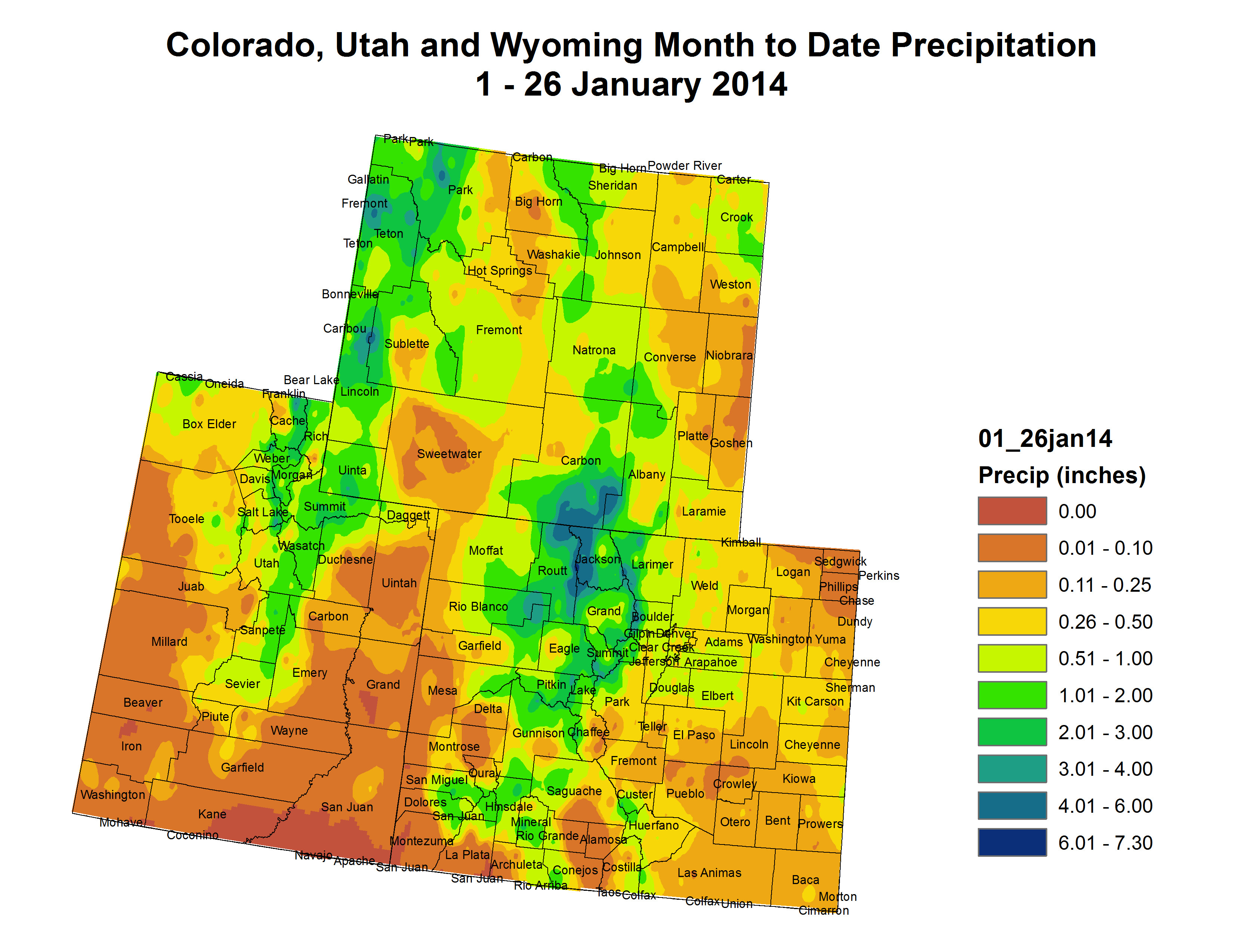
Click here to read the current summary. Click here to go to the NIDIS website hosted by the Colorado Climate Center.
More Colorado River Basin coverage here.
From Climate Central (Bobby Magill):
Changes in snowfall and snowpack melt patterns as temperatures rise could threaten the water supplies of numerous Southwestern cities that depend on the Colorado River for drinking water. Extreme weather and greater exposure to hurricane storm surge could become a regular threat to New York City and the New Jersey coastline, which are still recovering from Hurricane Sandy…
Colorado symbolizes how attitudes about managing the risks posed by climate change are different in parts of the West. Cities along Colorado’s Front Range urban corridor have drafted climate change action plans and the state has conducted studies analyzing climate change’s possible impacts in detail.
But like many states across the country, progress is hampered by uncertainty in how climate change will affect Colorado even as its recent disasters serve as a reminder of how vulnerable the state is.
Nobody knows for sure if Colorado will be wetter or drier in a warming world, and that has huge implications for urban growth along the Front Range and whether water-thirsty agriculture can be sustained in a state that is expected to grow by 50 percent to 8 million by 2040. What is certain is that Colorado will be warmer in the future, potentially creating drought conditions even if the state gets the same average rain and snow as it does today.
Studies show that Colorado will see average annual temperatures increase by 2.5°F, with summers warming by 5°F and winters by 3°F by 2050. Warmer temperatures mean changes in evaporation and soil moisture, reducing snowmelt runoff in each of Colorado’s river basins. More precipitation is expected to fall as rain rather than snow, and the state’s high-elevation snowpack — the source of much of the state’s water supply — could decline by 20 percent and melt earlier than in the past.
By 2070, the spring snowmelt runoff could begin up to 17 days earlier than today, while one of Denver’s most significant sources of water, the South Platte River, could see a decline in streamflow by up to 35 percent, according to the 2012 Joint Front Range Climate Vulnerability Study, which examined how streamflows in three of the state’s largest river basins will be affected in different climate change scenarios.
“Residential development for millions of additional people here will require a lot of water, yet water is already oversubscribed and 83 percent of our water is currently used for agriculture,” said Colorado State University atmospheric scientist Scott Denning. “As the climate warms, more water will evaporate and sublimate from mountain snowpacks before it ever reaches reservoirs, and agricultural demand will rise.”
That means there will be less water go to around as an ever-rising population conflicts with a decreasing water supply…
Local officials aren’t always up to date on the science of climate change, but they’re aware of water supply and demand, the stresses put on both and what that could mean for them, Denning said.
“What a lot of people don’t seem to ‘get’ is that drought is a running sum of evaporation minus precipitation, so increasing evaporation from warmer air leads to more drought even if precipitation stays the same,” he said. “There’s really nothing local governments can do to change future climate, but they must prepare for a much tighter water supply, for more frequent wildfire and occasional floods. This is common sense and not really new, but it is urgent.”[…]
And later this year, Colorado’s most comprehensive assessment of how climate change will impact the state and its drastically varied landscape will be published. The project is a joint Colorado State University and University of Colorado-Boulder study called the Colorado Climate Change Vulnerability Study, said its co-author, Eric Gordon, director of the Western Water Assessment at the National Oceanic and Atmospheric Administration Earth System Research Laboratory in Boulder.
There is a sense in Colorado that the high level of uncertainty about how climate change will affect the state and its water supply is a major hurdle to preparing for it.
“My sense is we’re somewhere in the middle of the pack (of the states preparing for climate change adaptation), but we’re highly sensitized by recent drought and flood,” said Reagan Waskom, director of the Colorado Water Institute at Colorado State University. “Climate change attribution is difficult, but the citizenry gets that it’s different — warmer temperatures and more extreme events.”[…]
Even though cities such as Denver and Fort Collins began drawing up plans to deal with climate change as early as 2007, the level of preparation and recognition of the threat climate change poses varies, Waskom said.
“It’s a mixed bag,” he said. “The challenge is not knowing what they’re planning for. We’re planning for an unknown future.”
Cities don’t know if they need to prepare for more frequent extreme weather events or an increase in average temperatures or precipitation — or both, he said.
“In the past, water utilities could look at past hydrology and weather patterns and relatively confidently know how to plan for the future,” Kaatz said.
Now, she said, utilities have to factor in timing of snowmelt, extreme weather events, the lifespan of the winter snowpack, changes in vegetation in watersheds, water evaporation and many other changes expected to be brought about by climate change.
“Another concern is that we can’t know the exact changes and timing of those changes in our region in the future,” Kaatz said. “The range of climate projections for Colorado is immense, showing the potential for not only varying amounts of warming, but also both wetter and drier conditions. This is different than what is projected for other regions in the southwest United States.”
Some Front Range cities have already begun to tackle “resiliency” to extreme weather regardless whether it is caused by climate change or anything else, said Lucinda Smith, environmental services director for the city of Fort Collins, whose mayor, Karen Weitkunat, was named in December as one of 16 local city officials from across the country to sit on the White House Task Force on Climate Preparedness and Resilience…
Some water suppliers, including the Northern Colorado Water Conservancy District, which provides supplemental water to cities and farmers north of Denver, believe that adapting to climate change means building new reservoirs. The district, known as Northern Water, has proposed building a large new reservoir north of Fort Collins, which would siphon high flows off the Cache la Poudre River during spring snowmelt season and store that water for future use.
But responding to climate change by building new reservoirs designed to capture water from snow that is expected to melt earlier and faster than ever before is creating a philosophical battle between those who want to build more reservoirs to shore up Colorado’s water supply and enivonrmentalists who are encouraging cutbacks in water use and taking water from agriculture as a way to achieve the same goal while preserving wildlife habitat.
Conservation groups in Colorado worry that Northern Water’s proposed new reservoir, part of the proposed Northern Integrated Supply Project, will destroy wildlife habitat in the river, which creates a wild ribbon of greenspace through the city of Fort Collins downstream of where water would be siphoned away for the new reservoir.
“Given the implications of climate change (wetter wets, drier drys), additional storage to capture the water when it is available is essential,” Northern Water General Manager Eric Wilkinson said, adding that both new reservoirs and water conservation are necessary to shore up the region’s water supply in a changing climate.
Laurna Kaatz, an environmental scientist and staff climate change expert at Denver Water, a regional water utility that collaborated with Northern Water, Fort Collins and other Front Range cities in the Joint Front Range Climate Vulnerability Study, said Denver Water is also looking for new water storage, and has plans to expand one of its major reservoirs.
Denning said another solution is for water to come from agriculture rather than expecting the state to sustain Colorado’s largest water consumer.
“In the West we say that water flows uphill toward money,” he said. “I expect that the only way to provide water for a 50 percent increase in urban populations will be for cities to buy enormous amounts of agricultural water rights. This will result in a drastic and permanent transformation of rural life as water is diverted from marginally productive farms and ranches to rapidly growing cities along the urban Front Range corridor.”

From the Aspen Daily News (Brent Gardner-Smith):
The CWCB is required by state law to determine if a proposed recreational in-channel diversion, or “RICD,” meets certain requirements. Having found that the county’s proposed water right for the Basalt kayak park passes the test, its written finding will now be sent to District 5 water court, which is reviewing the county’s water right application.
If the water court ultimately issues a decree for the new in-channel water right, it will form the basis of what will be known as the “Pitkin County River Park.”
The kayak park will include two surf waves created by placing two rock structures in the Roaring Fork River. The waves are designed to be accessible for beginner and intermediate kayakers, and would be rated at “green” and “blue” levels of difficulty, akin to the rating of ski trails.
The section of river is just below the Basalt bypass bridge on Highway 82 and above the confluence of the Roaring Fork and the Fryingpan rivers near downtown Basalt…
If the water right is decreed as presently configured, it would allow the county to call for differing levels of water to be sent down the Roaring Fork River to the Basalt kayak park.
From April 15 to May 17, the county could call for 240 cubic feet per second (cfs) of water to flow through the park. By comparison, the Roaring Fork River below Maroon Creek has been flowing at about 100 cfs in January.
Then, from May 18 to June 10, the county could call for 380 cfs. And during peak runoff, from June 11 to June 25, it could call for 1,350 cfs of water to flow through the kayak park and create the biggest surf waves of the season.
After June 25, the water right steps back down to 380 cfs until Aug. 20, and then back to 240 cfs until Labor Day…
The new water right would be “non-consumptive,” meaning the water would stay in the river and not be diverted for a “consumptive” use, such as irrigation.
The county applied for the new water right in water court in December 2010. If it is approved, the water right would have an appropriation date of 2010, making it a “junior” water right, compared to “senior” water rights dating back to the early 1900s or late 1880s, as many water rights in the region do.
As part of the water court process, the county has negotiated settlement agreements with over a dozen other water rights holders in the Roaring Fork River basin. As such, the scope of the county’s proposed water right has been narrowed.
For example, the length of the season when the new water right would be in effect was reduced by 25 days to a period between April 15 and Labor Day, and the county can only call for water from upstream junior water rights holders to flow through the park during daylight hours.
And the county agreed to a “carve out” provision that allows up to 3,000 acre-feet of new water rights to be developed upstream of the kayak park over the next 15 years, without being subject to the local government’s new water right.
Those provisions, and others, were enough to convince the CWCB board on Monday to rule in favor of the in-channel diversion water right.
There is, however, still one party objecting to the water right in state water court, the Twin Lakes Reservoir and Canal Co.
Twin Lakes diverts about 50,000 acre-feet of water each year off the top of the Roaring Fork river basin, primarily for municipal use in Colorado Springs, Pueblo, Pueblo West and Aurora.
Twin Lakes is concerned the water right for the kayak park will limit its ability to develop other new water rights in the Roaring Fork River basin in the future.
However, at the CWCB meeting, the water attorney for Twin Lakes sounded OK with new language approved by the board that was designed to address Twin Lakes’ concerns.
“It sounded positive,” [Pitkin County Attorney John Ely] said of Twin Lakes’ evolving position. “They have to go back to their board, and so, we’ll see.”
More whitewater coverage here.