Click here to go to the US Drought Monitor Website. Here’s an excerpt:
The Central and Northern Plains and Midwest
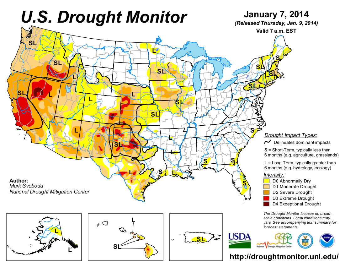
Bitter cold and snows swept across most of the Plains and Midwest this past week. Given the time of year, frozen soils and lack of impacts, no changes were made on the map this week as the dryness and drought remain freeze dried in place…
The West
There seems to be no relief in sight as the calendar flips over to 2014. Persistent ridging has kept precipitation at bay for many, leading to record-setting dryness for many locations in California and Oregon; this has become more of an issue of late in Washington as well. Even though California sees no changes on this week’s map, more deterioration could be coming soon given the weather pattern, or lack thereof, and concern for water supply, fire and other impacts grows each week the rains and snows don’t come. In fact, many locations in California reported the calendar year 2013 as being the driest on record [ed. emphasis mine], smashing previous record dry years (including 1976). One such example is Shasta Dam, where only 16.89 inches was reported in 2013, more than 11 inches below the previous record low of 27.99 inches in 1976. Shasta’s calendar year average is 62.72 inches. Upper elevation Sierra station snowpack and snow water equivalent (SWE) values in California have been abysmal for the Water Year (since October 1) as well. The historic low precipitation totals haven’t just been confined to the upper elevations either as dozens of locations have shattered their previous record low calendar year totals.
In the Pacific Northwest, D1 has pushed northward across western Oregon and into western Washington up to the Canadian border this week. Both snow pack and snow water equivalent SWE levels are very low as we move deeper into the wet season. In Idaho, D0 now covers the entire Panhandle and has pushed into more of extreme northwestern Montana. The D3 pockets in southern Idaho have been combined and D3 now stretches across most of the southern part of the state.
The Southwest has also been dry for the Water Year as the monsoon season is now out of the rear view mirror as we head into the second half of the wet winter season. The resultant lack of precipitation means D0-D2 has expanded slightly in southern and central Arizona as well as in northwestern Arizona, where D2 has pressed southward out of extreme southern Nevada. Southern New Mexico also sees a slight expansion of D1 this week…
Looking Ahead
During the January 9-13, 2014, time period, a strong ridge appears primed to set up camp for the next couple of weeks, bringing better prospects for well above-normal temperatures across most of the country. The only notable exception is southwestern Colorado, where temperatures are expected to be slightly below the norm. A strong storm system could bring the first considerable widespread winter event to the Pacific Northwest, particularly the western halves of Oregon and Washington as well as the Idaho Panhandle. Good moisture is also predicted for the southern Plains (eastern Kansas, eastern Oklahoma and eastern Texas), Lower Mississippi Valley, Gulf Coast and the Southeast. The Northeast may also see some good precipitation materialize over this period. The Southwest and northern Plains look to remain dry.
For the ensuing 5 days (January 14-18, 2014), the ridging pattern looks to remain entrenched bringing better odds of continued above-normal temperatures across the entire West and into the western Plains from Texas northward to North Dakota. New England is another region looking to share in the warmth. Alaska, the Great Lakes and the Gulf Coast appear to be headed for below-normal temperatures. As for precipitation, this pattern tilts the odds toward below-normal for the West and central and southern Plains while Alaska, the northern Plains, Great Lakes and the eastern Seaboard can expect a better chance of above-normal precipitation.