Secretary Jewell Presents 2013 Partners in Conservation Awards #ColoradoRiver

Jonathan Waterman paddling the ooze in the Colorado River Delta

Here’s the release from the Bureau of Reclamation. Here’s an excerpt:

Minute 319 Bi-National Partnership
For decades, environmental and water supply concerns over the Colorado River have been the subjects of controversy, dispute, and litigation along the U.S.-Mexico border. After years of intense negotiation, a historic partnership agreement, “Minute 319,” has been touted as one of the most innovative negotiated agreements between nations to include environmental river flows. Signed in November 2012, Minute 319 provides the authority and framework under the 1944 Water Treaty to implement actions under consideration by multiple administrations dating back to the late 1990s. This implementing agreement was only possible with the partnership of the Colorado River Basin states, water users and environmental organizations in both countries, and it provides a unique example of cooperation for other basins worldwide.

More Colorado River Basin coverage here/a> and here.

‘New Mexico drought forecast looks bad, but hey, at least we’re not as bad off as California!’ — John Fleck

US Drought Monitor January 14, 2014

Click here to go to the US Drought Monitor website. Here’s an excerpt:

Central Plains
Rain, ice, and snow in eastern portions of the region contrasted with mostly dry weather on the central High Plains, where Severe to locally Exceptional Drought (D2-D4) persist. Much of the Central Plains’ Extreme Drought (D3) has received less than half of normal precipitation over the past 90 days, while precipitation totals in the D4 area of southeastern Colorado during the same period are less than 30 percent of normal (locally less than 20 percent). These same Exceptional Drought areas are also exhibiting extremely low (D4-equivalent) Standardized Precipitation Indices (SPI) dating back over the past 24 to 36 months, highlighting the ongoing long-term component to the central Plains’ drought as well…

Southern Plains and Texas
Despite a pair of storms brushing the region, most of the core drought areas of Texas and the southern Plains remained dry. Rain, ice, and snow (0.25 to 1.50 inches) were limited to eastern-most portions of Texas and Oklahoma, offering little in the way of drought relief. Short- and long-term drought is prevalent from northern Texas into central Oklahoma, where 90-day precipitation has totaled 50 percent of normal or less (locally less than 30 percent of normal). Topsoil and subsoil moisture remained extremely limited across much of north-central Texas and neighboring portions of Oklahoma; soil moisture percentile rankings are in the 5th percentile or lower in the Extreme and Exceptional Drought (D3-D4) areas of the southern Plains. The drought continues to take a toll on Texas’ winter wheat, which was rated 38 percent very poor to poor as of January 12. In southeastern Texas, areas that mostly missed the past week’s 1-inch rainfall were included in the expanded D0 area (Abnormally Dry) to reflect drier-than-normal conditions over the past 60 days (50 to 60 percent of normal) and increasingly low soil moisture (10th percentile or lower)…

Western U.S.
Despite the arrival of rain and high-elevation snow in the Northwest, drought persisted or intensified across the region. The most notable drought increases were from central California into the Pacific Northwest.

In northern portions of the region, a surge of Pacific moisture generated rain and mountain snow from the Cascades into the northern Rockies. Precipitation totals were highly variable, with 2- to 7-inch totals (liquid equivalent) in the northern Cascades contrasting with amounts generally less than 2 inches over southern portions of the range. Despite the moisture, the post-event statistics highlighted the intensifying drought in the region. The updated water-year precipitation totals stood at a meager 15 to 25 percent of normal in the Salmon Mountains of northwestern California, 25 to 55 percent in western Oregon, while northern portions of the Cascades (Washington) averaged 55 to 85 percent of normal precipitation for the water year. Snow Water Equivalent (SWE) in the Cascades of Oregon averaged 10 to 35 percent of normal, while the mountains of western Washington fared slightly better (30 to 60 percent of normal). Consequently, Severe Drought (D2) was expanded northward — despite the precipitation — to account for SWE rankings in the 15th percentile or lower (locally below the 5th percentile). SWE rankings in the eastern portions of Washington’s Cascades are likewise mostly in the 20th percentile or lower (locally in the lowest 5th percentile), reflecting the abnormally warm weather which has resulted in much of the precipitation falling as rain. Moderate Drought (D1) was also expanded across the Columbia River Valley in northern Oregon and central Washington due to increasing short-term dryness (water-year precipitation at 20 to 45 percent of normal) and declining soil moisture.

Farther south, a disappointing water year continued, with warm, dry weather firmly entrenched from central and southern California into the Great Basin. Most notably, Extreme Drought (D3) expanded across much of central and northern California into northwestern Nevada. Water-year precipitation in most of the D3 area was now less than 20 percent of normal, with locales from the southern San Joaquin Valley to the Pacific Coast reporting less than 10 percent of normal. Mountain snowpacks in the Sierra Nevada continued to dwindle as well, with SWE averaging between 10 and 30 percent of normal (10th percentile or lower, with many locations now in the bottom 5th percentile). Soil moisture across the northern two-thirds of California remained in very short supply, with similar moisture shortages noted in northwestern Nevada.

In the Four Corners region, changes to this week’s drought depiction were minimal. Minor increases were noted in D0 (Abnormal Dryness) across southwestern Colorado, while locally heavy precipitation (1 to 2 inches liquid equivalent, locally more) led to some D0 reduction in north-central Colorado. Otherwise the region remained mostly in a holding pattern with respect to drought intensification, with drought concerns most pronounced (water-year precipitation less than 50 percent of normal) from southeastern Arizona into central and eastern New Mexico. [ed. emphasis mine][…]

Looking Ahead
Little — if any — drought relief is expected from the Plains to the Pacific Coast states, with precipitation during the upcoming monitoring period mostly confined to the northeastern quarter of the nation. A stronger-than-normal ridge of high pressure will span from the Canadian Rockies into the Southwest, maintaining dry, warmer-than-normal weather across much of the west. Temperatures will regularly top the 60-degree mark as far north as the central High Plains, and will exceed 80°F in the Desert Southwest. Farther east, a modest surge of cool air into the eastern one-third of the U.S. will be followed by another round of below-normal temperatures across the Midwest and East toward week’s end. On Wednesday night and Thursday, a high-wind event can be expected across the northern and central Plains and the western Corn Belt, while blizzard conditions will affect the Red River Valley. The NWS 6- to 10-day outlook for January 21-25 calls for near- to below-normal temperatures from the Mississippi Valley to the East Coast, while warmer-than-normal weather will continue from the Pacific Coast to the Plains. Meanwhile, near-normal precipitation from the Great Lakes region into the Northeast will contrast with drier-than-normal conditions across the remainder of the country.

Fort Collins loses 1985 Halligan Reservoir conditional storage right, no diligence filing

Reservoirs NW of Fort Collins

From the Northern Colorado Business Report (Steve Lynn):

The Coloradoan first reported last week that the city had lost the water right due to failure to file the required paperwork. Utilities officials said Wednesday they did not know the value of a water right canceled by a water court last month.

“It’s not a straight calculation,” Lisa Rosintoski said. “There are a lot of variables involved. Our efforts are to quantify that accurately.”

The city bought the junior water right in 1985 as part of a project to expand Halligan on the North Fork of the Poudre River from 6,400 acre-feet to 21,000 acre feet. The expansion is part of the Halligan-Seaman Water Management Project, which involves expanding Fort Collins’ Halligan Reservoir and Greeley’s Milton Seaman Reservoir…

The utility’s conditional water right amounted to more than 33,000 acre feet…

City officials say, however, that the loss of the water right will not affect the Halligan expansion.

“We have the water rights to support filling the bucket,” Rosintoski said.

Utilities officials will report to City Council on the value of the water right and what impacts the lost water right might have, if any. A date for such a presentation hasn’t been set yet.

“We need to do some internal analysis on how you break out what we spent on the project to try to figure out what the price of the right would be,” said Donnie Dustin, water resource manager for Fort Collins Utilities.

More Cache la Poudre River Watershed coverage here and here.

NRCS: Year’s First National Water Forecast Predicts Limited Supply West of the Continental Divide

Streamflow forecasts January 1, 2014 via the NRCS

Here’s the release from the NRCS:

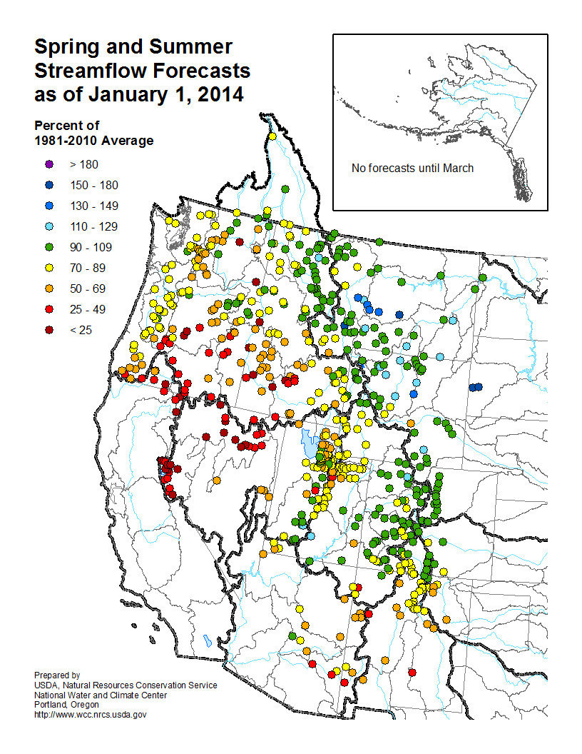
A limited water supply is predicted west of the Continental Divide, according to the USDA Natural Resources Conservation Service (NRCS) National Water and Climate Center (NWCC) in its first forecast of 2014. The NWCC also predicts normal water supply east of the Continental Divide and will continue to monitor, forecast and update water supplies for the next six months.

Monitoring snowpack of 13 western states, the center’s mission is to help the West prepare for spring and summer snowmelt and streamflow by providing periodic forecasts. It’s a tool for farmers, ranchers, water managers, communities and recreational users to make informed, science-based decisions about future water availability.

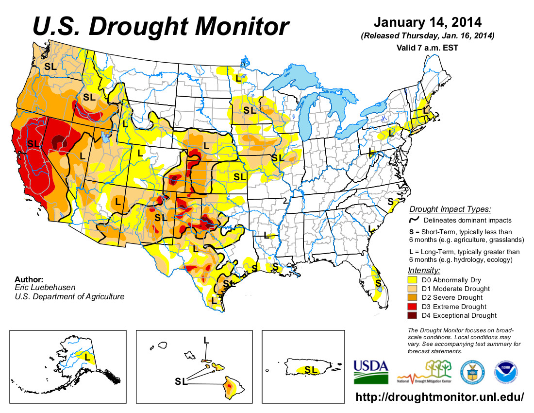
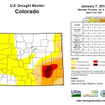
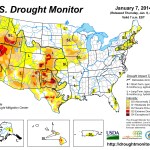
“Right now the West Coast is all red,” NRCS Hydrologist Tom Perkins said. “Early indications are it will be very dry in the western part of the West, but wetter as you travel east. There are some exceptions to this, as New Mexico, Arizona, parts of Utah and southern Colorado are also expected to be dry.”

“But that could all change by the end of the season. This early in the season – who knows? It always changes,” Perkins said.

The National Oceanic and Atmospheric Administration’s (NOAA) Climate Prediction Center’s seasonal forecast is calling for a milder and somewhat drier winter for much of the West. According to NRCS Meteorologist Jan Curtis there is a very small chance for normal precipitation on the West Coast.

“The North Cascades in Washington might have a normal year, but Oregon and California are unlikely to have normal precipitation,” Curtis said.

NRCS Oregon lead Snow Surveyor Melissa Webb said she isn’t alarmed yet.

“Oregon snowpack looks grim right now, but the season is young and storms are on the horizon,” Webb said. “While concerned, we’re hopeful for some recovery in the next couple of months.”

Although NRCS’ streamflow forecasts do not predict drought, they provide information about future water supply in states where snowmelt accounts for the majority of seasonal runoff.

In addition to precipitation, streamflow in the West consists largely of accumulated mountain snow that melts and flows into streams as temperatures warm into spring and summer.

NRCS scientists analyze the snowfall, air temperature, soil moisture and other measurements taken from remote sites to develop the water supply forecasts.

“USDA streamflow forecasts play a vital role in the livelihood of many Americans,” NRCS Chief Jason Weller said. “With much of this region greatly affected by drought, our experts will continue to monitor snowpack data and ensure that NRCS is ready to help landowners plan and prepare for water supply conditions.”

Since 1935, NRCS has conducted snow surveys and issued regular water supply forecasts. Since the late 1970s, NRCS has been installing, operating and maintaining an extensive, high-elevation automated system called SNOTEL, designed to collect snowpack and related climatic data in the western United States and Alaska.

View January’s Snow Survey Water Supply Forecasts map or view information by state.

Click here for the Colorado forecast discussion.

Drought news: The #COdrought is not over by a long shot, 15 counties designated by USDA

From The Pueblo Chieftain (Chris Woodka):

Pueblo and 14 other Colorado counties have received drought disaster designation from the U.S. Department of Agriculture. The designation makes farmers in the counties eligible for federal assistance, including Farm Service Agency emergency loans.

The Arkansas Valley has been in a widespread drought since August 2010, but some areas have experienced drought conditions since 2000. [ed. emphasis mine] Lower precipitation, decreased stream flows and declining soil moisture levels have degraded farm and rangeland. Farmers have thinned cattle herds and cut back on production.

Ten other counties contiguous to those also are in the drought disaster declaration.

“Farmers in Southeastern Colorado are facing extreme drought conditions that are devastating their crops and hurting local economies,” U.S. Sen. Michael Bennet said. “The availability of these needed resources will be welcome news for struggling family farms that have worked this land for generations.”

Bennet added the designation underscores the need for a comprehensive farm bill to give agricultural producers more certainty and stability.

The counties included in the drought designation are: Baca, Bent, Cheyenne, Crowley, El Paso, Kiowa, Kit Carson, Las Animas, Lincoln, Otero, Phillips, Prowers, Pueblo, Sedgwick and Yuma. Surrounding counties are: Arapahoe, Costilla, Custer, Douglas, Elbert, Fremont, Huerfano, Logan, Teller and Washington.