Bob Beauprez expected to announce gubernatorial campaign — The Denver Post

From The Denver Post (Kurtis Lee/Lynn Bartels):

Former Congressman Bob Beauprez, who has widely been expected to jump into the GOP gubernatorial primary, is expected to enter the race early next week.

GOP sources told the Denver Post that Beauprez has been looking at office space in the Denver Tech Center and at staffing hires.

FOX 31 Denver reported that Beauprez will enter the gubernatorial race Monday, the same day he’s expected to appear in Washington, D.C., before the Republican National Committee in an effort to lure the 2016 convention to Denver.

Beauprez, who lost the governor’s race to Democrat Bill Ritter in 2006, could not be reached for comment Friday. His personal website now reads “coming soon” and “2014.”

The frontrunner in this year’s crowded field, former Congressman Tom Tancredo, said he called Beauprez last week and said, “You keep telling me all these people are calling you to tell you to get in. Well, count me as one of them. Get in.”

But Tancredo said he told Beauprez that didn’t mean he would jump out of the race.

“I’m committed to this thing until somebody can show me a person that can raise millions of dollars that I can’t or has polling that shows he or she is going to walk away with it,” Tancredo said.

Tancredo leads a pack that includes Republican Secretary of State Scott Gessler, state Sen. Greg Brophy, former state Sen. Mike Kopp and businessman Steve House. The winner of the June 24 GOP primary faces Democratic Gov. John Hickenlooper, who is vying for a second term and in recent polls has outpaced all of his prospective challengers.

More 2014 Colorado November election coverage here.

USGS: Cross-ecosystem impacts of stream pollution reduce resource and contaminant flux to riparian food webs

Macro Invertebrates via Little Pend Oreille Wildlife Refuge Water Quality Research

Click here to go to the Ecological Society of America website to download a copy of the report. Here’s the pitch:

The effects of aquatic contaminants are propagated across ecosystem boundaries by aquatic insects that export resources and contaminants to terrestrial food webs; however, the mechanisms driving these effects are poorly understood. We examined how emergence, contaminant concentration, and total contaminant flux by adult aquatic insects changed over a gradient of bioavailable metals in streams and how these changes affected riparian web-building spiders. Insect emergence decreased 97% over the metal gradient, whereas metal concentrations in adult insects changed relatively little. As a result, total metal exported by insects (flux) was lowest at the most contaminated streams, declining 96% among sites. Spiders were affected by the decrease in prey biomass, but not by metal exposure or metal flux to land in aquatic prey. Aquatic insects are increasingly thought to increase exposure of terrestrial consumers to aquatic contaminants, but stream metals reduce contaminant flux to riparian consumers by strongly impacting the resource linkage. Our results demonstrate the importance of understanding the contaminant-specific effects of aquatic pollutants on adult insect emergence and contaminant accumulation in adults to predict impacts on terrestrial food webs.

Credit: Johanna M. Kraus, Travis S. Schmidt, David M. Walters, Richard B. Wanty, Robert E. Zuellig, and Ruth E. Wolf

More USGS coverage here.

Governor’s Forum on Colorado Agriculture recap: There is no typical consumer anymore

Sugar beets back in the day via UC Berkeley

From The Greeley Tribune (Eric Brown):

The agriculture industry convened Thursday to discuss ways of better connecting with consumers now and into the future — when food buyers will be far different than they were just a few years ago. It’ll be no easy task, they were told. Many left the Governor’s Forum on Colorado Agriculture with more questions than answers.

As was noted by industry experts who spoke, many of today’s consumers put value on food that’s “local,” or “organic,” or “naturally raised,” or “anti-biotic free,” or “cage-free,” although many food buyers admit confusion regarding the details of those labels, and also reveal they’re only willing to pay so much more for it.

“They want it all, and they want it at a fair price,” said Dawn Thilmany, a Colorado State University professor and economist, who shared results from a state survey of food consumers.

Bottom line, Thilmany and others noted: “There is no typical consumer anymore.”

Added Alan Reed with Dairy Management Inc., who shared results from a nationwide consumer survey, “the era of mass marketing is over. Everybody wants the product they want, delivered by a company ‘that totally gets me.’”

Those talks were part of the annual all-day ag forum this year “Titled Farm To Table,” which brought together state ag officials, experts and farmers and ranchers, and featured a brief speech from Gov. John Hickenlooper.

Among the other facts and figures shared by Reed and others; the U.S. population that’s 55 and older will grow by 45 percent by 2020, while the number of people in the U.S. 18 and younger will decrease by 8 percent by that time.

By 2020, 75 percent of the population is expected to be overweight. The obesity rate will double, 20 percent of the population will have arthritis, 40 percent will have heart disease and 50 percent will have diabetes.

“And all of this will impact how we market our products,” he said.

Also, men are expected to be the primary grocery shopper of the household by 2020. Right now, 31 percent of men are the primary grocery shopper in the household, Reed noted.

Reed also spoke of the “loss of the middle.” People today, and likely into the future, either want gourmet food or something really cheap.

“There are a lot of ag products that go into Kraft Mac And Cheese … but no one’s really eating things like that any more,” Reed said.

Dieting has changed, he added. Everyone’s overstressed — “but not everyone wants 5-hour Energy. They want something else,” he said.

People are having less kids, and parents want to be friends with their kids — and as a result, are changing how they feed them.

People snack more. Reed’s survey results showed only 17 percent of people don’t snack, and some snack as many as five times per day.

People don’t trust products — they trust brands, he added.

Technology, too, is changing. Average appliances will include refrigerators that keep track of inventory and make grocery lists. In South Korea, smart phones scan food billboards at train stations that automatically charge consumers for wanted items, and then have the food delivered to their homes by the time they get home.

“We must do a better job understanding the needs out there and how they’re changing,” he said. “It’s going to take a multi-faceted, personalized approach. We have to immerse ourselves into consumer experience.”

“But there’s always room for new products,” Reed added.

CDOT is planning for runoff flooding #COflood

Flood damage Big Thompson Canyon September 2013 -- photo via Northern Water
Flood damage Big Thompson Canyon September 2013 — photo via Northern Water

From the Fort Collins Coloradoan:

Spring flooding could destroy some CDOT repairs to major highways destroyed in September, said Sheaffer, who said he has obsessively monitored the state’s above-average snowpack.

“We have a 25- to 50-year (flood) event coming to us if it’s just a normal spring runoff,” said Sheaffer, who has become CDOT’s chief of operations for flood recovery efforts since September.

Although CDOT is still working to repair $535 million in damage done to Front Range roads, road repair is only a sliver of the long-term recovery concerns that flood and stormwater experts discussed on Thursday. Hosted by the Colorado Association of Stormwater and Floodplain Managers and Colorado State University, the 2013 Colorado Flood Forum covered subjects ranging from climate and weather to water quality issues.

The conference also served a statewide debrief on the September floods that killed eight people and destroyed more than 1,500 Front Range homes.

Panelists recalled horror stories of endless work days and sleepless nights. Mike Chard with the Boulder County Office of Emergency Management recalled moments when he was convinced that hundreds of people had died in a crush of floodwater. He compared dealing with the endless rain and ongoing flood as “getting punched in the face every five minutes with a new problem.”

Drought news: Southeastern Colorado is still hurting #ColoradoRiver #COdrought

US Drought Monitor February 25, 2014

Click here to go to the US Drought Monitor website. Here’s an excerpt:

Summary

California remained the focal point of a U.S. drought that stretches from the Pacific Coast to portions of the Mississippi Valley. During the 7-day drought-monitoring period, which ended early on February 25, generally dry weather prevailed in key drought areas from California to the southern High Plains. Farther north, however, rain and snow further chipped away at dryness and drought in the Northwest. Emerging dryness became an issue from the eastern Plains (Kansas to Texas) eastward into the middle and lower Mississippi Valley, while heavy rain fell in the central Gulf Coast region. Elsewhere, the year’s first widespread severe weather outbreak—accompanied by locally heavy showers—struck the Southeast and lower Midwest on February 20-21, while wind-driven snow fell from Iowa northward into the upper Great Lakes region…

Central and Southern Plains

Dry weather dominated the central and southern Great Plains, although warmth yielded to colder conditions. There were broad expansions of various categories of dryness and drought in southeastern Kansas and parts of Oklahoma and Texas. In Texas, the portion of the winter wheat crop rated in very poor to poor condition climbed to 47 percent on February 23, up from 28 percent in late-November 2013. Additionally, 52 percent of Texas’ rangeland and pastures were rated very poor to poor on February 23, up from 30 percent just 3 months ago. Spring planting is underway across Deep South Texas (e.g. Texas corn was 3 percent planted, statewide, by February 23), and moisture will be needed soon as fieldwork moves northward. By February 23, statewide topsoil moisture was rated 75 percent very short to short in Texas. Roughly the southern half of the Great Plains region is facing a potential fourth consecutive summer of drought—a stretch that began with the historic drought of 2011. Texas cotton abandonment, which until recently only exceeded 40 percent only once (in 1998), has topped 40 percent in three consecutive years (2011, 2012, and 2013)…

The West

Record-setting warmth accompanied dry weather from California into the Southwest, while beneficial precipitation fell from the Pacific Northwest to the northern Rockies. Benefits of California’s early-February precipitation are being overcome by resurgent warmth and dryness, leading to rapid expansion of extreme to exceptional drought (D3 to D4) into the San Joaquin Valley and the southern Sierra Nevada. By February 26, the California Department of Water Resources reported that the Sierra Nevada snowpack contained an average of 5 inches of liquid, just 22 percent of the late-February normal. Prior to the early-February storminess, the water equivalency of the Sierra Nevada snowpack was 3 inches, about one-sixth of the end-of-January normal.

From a broader perspective, California completed its 12th-driest year from July 1, 2011 – June 30, 2012, and its 11th-driest year from July 1, 2012 – June 30, 2013, according to the National Climatic Data Center. During the last 120 years, the only comparable period for dryness occurred from July 1, 1975 – June 30, 1977, when California experienced its fourth- and third-driest years on record. However, that drought ended with heavy winter precipitation in 1977-78. This year, California is on track to complete one of its driest years on record; the period from July 1, 2013 – January 31, 2014, broke an all-time record for dryness. Heat has certainly not helped California’s drought situation; Needles—with a high of 90°F on February 19—reported its earliest ever 90-degree reading (previously, 90°F on February 24, 1904). Sandberg, California, has reached or exceeded the 70-degree mark on 7 days in February; the previous standard of 4 days was established in February 1963.

California’s drought impacts continue to mount, with one of the most recent blows to agriculture being that the Central Valley Project plans to deliver no water to many growers in 2014. The most senior rights holders are pegged to receive 40 percent of their normal water. Those allocations could change if reservoir storage were to improve. Some growers could make up the loss by pumping groundwater or buying water from senior rights holders.

Meanwhile, significant long- and short-term drought persisted or intensified in the Great Basin and the Southwest. Arizona’s rangeland and pastures were rated 60 percent very poor to poor on February 23, up from 24 percent at the beginning of 2014. Statewide reservoir storage was barely one-quarter of normal for this time of year in Nevada and just over half of normal in New Mexico. Farther north, Pacific storms led to reductions in coverage of dryness and drought from the Pacific Northwest to the northern Rockies. In fact, no drought remained along the eastern slopes of the Rockies from Montana to northeastern Colorado…

Looking Ahead

From February 27 – March 3, precipitation will engulf much of the West. Five-day precipitation totals could reach 2 to 4 inches or more in the Sierra Nevada and 3 to 6 inches along the California coast. Totals of 1 to 3 inches will be common elsewhere in the West, except for locally higher amounts on Arizona’s Mogollon Rim. Late in the period, a sprawling storm will affect the central and eastern U.S. Snow, sleet, and freezing rain can be expected across portions of the Plains, Midwest, Mid-South, and Mid-Atlantic States. Another strong surge of frigid air will trail the storm into the Plains and Midwest. The NWS 6- to 10-day outlook for March 4-8 calls for below-normal temperatures from the Plains to the East Coast, except for warmer-than-normal weather in southern Florida. Warmth can be expected west of the Rockies, excluding areas near the Canadian border. Meanwhile, above-normal precipitation in the Pacific Northwest and the Atlantic Coast States will contrast with drier-than-normal conditions in a broad area stretching from central and southern portions of the Rockies and Plains into the middle Mississippi Valley.

West slope ag producers, feeling pressure, are lining up to provide input to the #COWaterPlan #ColoradoRiver

Colorado Water Plan website screen shot November 1, 2013

From the Glenwood Springs Post Independent (Kathleen Curry):

For several months now a group of agricultural producers on the Colorado River have been meeting to develop their section of the pending Colorado Water Plan. Whether you are a wine producer in Mesa County or a cattle producer in Grand County, water is the key to success and survival. And even though the snowpack is looking pretty good at the moment, there isn’t enough water to meet all of today’s needs let alone new future demands.

Agricultural water users are feeling pressure from a number of directions. Looking upstream, they see a growing population on the Front Range of Colorado. Water users east of the continental divide have not minced words regarding their desire to transfer additional water from West Slope agricultural users to the Front Range. Looking downstream, agricultural water users on the Colorado watch the declining levels of Lake Powell and Lake Mead and speculate as to how much of the water they are currently relying on to raise their crops will have to be bypassed to meet Colorado’s compact obligations. And last, but not least, population numbers within the Colorado Basin are on the rise, and pressure to sell agricultural water for municipal use is ever-present.

The agricultural section of the Colorado River “Basin Implementation Plan,” developed by the Colorado Basin Roundtable with help from the consulting firm SGM, will be incorporated into the statewide Colorado Water Plan that Governor Hickenlooper is seeking to finalize by year’s end. The Colorado Basin Roundtable, like its counterparts in other major river basins around the state, is a group of water managers and stakeholders charged by the state legislature with doing “bottom-up” water planning. SGM is working with agricultural water users throughout the river basin to determine what their needs are and what kinds of projects and methods would help them be more prepared for the future.

A number of themes have emerged during the roundtable discussions to date. These include a desire to address the existing shortage of water supply available to agricultural users, consensus by all that additional transmountain diversions would harm agricultural production, a desire to preserve the right of an individual landowner to do what he or she wants with their property and water rights, and general agreement that improved agricultural efficiencies would have limited water supply benefits in the basin. The discussion participants have also concluded that administration of the Colorado River Compact due to a failure to meet downstream obligations would have a negative impact on the viability of long-term agricultural production in the basin.

The Colorado Basin Implementation Plan agricultural discussion group will continue to meet in conjunction with the monthly meetings of the Colorado Basin Roundtable. Next on the agenda will be identifying individual projects and methods that could provide agricultural benefits in the Colorado Basin.

If you would like to join in on the conversation, we would love to hear from you. Meetings are held the third Monday of the month at noon at the Glenwood Springs Recreation Center. For more information, please feel free to contact Angie Fowler at SGM, AngieF@sgm-inc.com. To learn more about the Colorado Basin and statewide water planning processes, go to http://www.coloradobip.sgm-inc.com. You can also contribute your knowledge and opinions by taking a short survey a http://www.surveymonkey.com/s/ColoradoBasinAg.

More Colorado Water Plan coverage from the North Denver News:

Residents of the Denver metro area and northeast Colorado – including homeowners, farmers, ranchers, business owners, environmentalists and recreationalists interested in knowing more about Colorado’s water – are encouraged to attend any of four public information and input meetings to be held in March and April in Denver, Longmont, Fairplay and Yuma.

The South Platte Basin and Metro Roundtables, composed of diverse volunteers representing agricultural, municipal, recreational and industrial water users and environmental interests from the headwaters communities to the Nebraska state line, were created by the state legislature in 2005, along with seven other roundtables representing each of the state’s river basins. They are charged with determining how to meet Colorado’s significant water supply shortfalls anticipated by 2050. Since 2005, the basin roundtables have brought together more than 300 representatives of these interests to discuss water supply planning and other water issues.

The roundtables are currently working under an executive order issued by Governor John Hickenlooper in May 2013, requiring the Colorado Water Conservation Board to develop a Colorado Water Plan by December 2015. This statewide plan will detail how Colorado will manage its diverse water needs in the future. At a local level, the roundtables are developing Basin Implementation Plans outlining how to meet predicted water needs for all uses.

Chairs of both Roundtables emphasized that the South Platte Basin represents a critical piece of Colorado’s water future and are encouraging all interests to participate in the process.

“Finding the correct balance and tradeoffs of water uses is vital to ensuring a sufficient water supply in the future. To find that balance, everyone needs to work together,” said Sean Cronin, chair of the South Platte Basin Roundtable. “Whether you live in Fort Collins, Sterling, Denver, or Idaho Springs, there is a meeting taking place near you and we want the public to attend and be part of the process.”

[Mark] Koleber, chair of the Metro Roundtable, reinforced the importance of public participation. “We are developing the South Platte Basin’s plan now. The public’s thoughts and suggestions will be vital to the success of our plan and we are urging all to provide input.”

The meetings will be held from 4-6 p.m. on the dates and at the locations indicated below. Roundtable representatives will also be available starting at 3:30 p.m. until up to 7 p.m. for informal discussions. The meetings are free and open to the public. More information about the South Platte Basin Plan is available at http://www.southplattebasin.com.

More Colorado Water Plan coverage here.

I am proud the U.S. Bureau of Reclamation heeded my calls and quickly approved the Arkansas Valley Conduit — Senator Mark Udall

Arkansas Valley Conduit Comanche North route via Reclamation

Here’s the release from the US Bureau of Reclamation (Tyler Johnson):

Bureau of Reclamation Great Plains Regional Director Michael Ryan has signed the Record of Decision for the Arkansas Valley Conduit and Long Term Excess Capacity Master Contract Final Environmental Impact Statement. The selected alternative is construction of the Arkansas Valley Conduit using the Comanche North Alternative.

“This project will help water providers throughout the Arkansas River Basin meet existing and future demands,” said Ryan. “While funding details remain to be coordinated, it is prudent this project move forward to be in a position to take advantage of federal, state or local funding opportunities when they arise.”

The Arkansas Valley Conduit is a feature of the Fryingpan-Arkansas Project. It will provide treated water to communities in southeastern Colorado. When complete, the pipeline for the Arkansas Valley Conduit could be up to 227 miles long. The Comanche North Alternative includes three federal actions:

  • Construct and operate the Arkansas Valley Conduit and enter into a repayment contract with Southeastern Colorado Water Conservancy District.
  • Enter into a conveyance contract with various water providers for use of a pipeline interconnect between Pueblo Dam’s south and north outlet works.
  • Enter into an excess capacity master contract with Southeastern Colorado Water Conservancy District to store water in Pueblo Reservoir.
  • “For the many small rural water providers the conduit will serve, this critical step in the process of building the project is greatly welcomed. Facing the water quality and waste water discharge compliance challenges has been daunting for this area, and the congressional approval in 2009 and now the Record of Decision from the Bureau of Reclamation provide real hope for an effective and efficient way to meet those challenges,” said Bill Long, President of the Southeastern Colorado Water Conservancy District.

    A Record of Decision is a decision document; it concludes the environmental impact statement prepared in compliance with the National Environmental Policy Act. It does not provide or allocate funding for the project. Reclamation published the final environmental impact statement in August, 2013.

    “The District is grateful for this decision, which is one more milestone in a half-century journey to a clean water supply for southeastern Colorado. As federally-mandated standards have changed, the need for the solution the preferred alternative provides is even greater. The promise to build this piece of the project was first made in 1962 by President Kennedy and was restated in 2012, right here in Pueblo, Colorado, by President Obama. Now let’s move forward to the next phases of design and construction,” said Jim Broderick, General Manager for the Southeastern Colorado Water Conservancy District.

    For more information on the Record of Decision, please visit http://www.usbr.gov/avceis. To obtain a hard copy of the Record of Decision, contact Doug Epperly at (406) 247-7638 or depperly@usbr.gov.

    From The Pueblo Chieftain (Chris Woodka):

    The Bureau of Reclamation approved the final construction plan for the Arkansas Valley Conduit Thursday.

    “It’s been a long haul,” said Bill Long, president of the Southeastern Colorado Water Conservancy District, sponsors of the conduit. “This critical step in the process of building the project is greatly welcomed.”

    The record of decision for the project was signed by Michael Ryan, Reclamation’s regional director. The record of decision includes the environmental impact study for the conduit, but the next step will be to obtain funding from Congress to build the project.

    Long, a Bent County commissioner and Las Animas business owner, has been working to get the conduit built since he joined the Southeastern board in 2002. The conduit was included in the 1962 Fryingpan-Arkansas Project legislation, but never built because of the expense.

    “In the last few months, it’s become clear that this will help, not only with drinking water, but at the other end with wastewater quality as well,” Long said.

    Reclamation Thursday approved a record of decision for the Comanche North route of the 227-mile pipeline from Pueblo Dam to Lamar. The chosen route includes initial treatment at the Pueblo Board of Water Works’ Whitlock treatment plant and a pipeline that swings south of Pueblo near the Comanche power plant.

    The conduit will deliver fresh drinking water to 50,000 people in 40 communities east of Pueblo. It is estimated to cost $400 million, which would be repaid partly through revenue from Fry-Ark contracts.

    Also included in the decision is a master storage contract in Lake Pueblo for the Southeastern district and a cross-connection between north and south outlets at Pueblo Dam.

    The storage contract will set aside space for conduit participants and other water users in the district.

    The Southeastern district is focused on funding the project. Political wrangling delayed the record of decision and federal belt-tightening limited appropriations to about $2 million this year, rather than the $15 million the district hoped for.

    “I think this is a really important step forward, and I’m very happy,” said Jim Broderick, executive director of the Southeastern district. “We still have a lot of work to do in funding the project.”

    From the Colorado Springs Independent (Pam Zubeck):

    The Bureau of Reclamation signed the Record of Decision today for a project that’s been in the planning stages since Pueblo Dam was built in the 1960s.

    Part of the Frying Pan-Arkansas project, the conduit has never been built due to lack of money.

    U.S. Sens. Michael Bennet and Mark Udall, Democrats of Colorado, issued a news release after the ROD was signed, which follows approval of an Environmental Impact Study last year.

    Here’s a release from Senator Udall’s office:

    U.S. Senators Mark Udall and Michael Bennet welcomed today’s signing of the Record of Decision for the Arkansas Valley Conduit, which represents a major milestone for the project that will bring clean water to communities in southeastern Colorado. The decision comes after Bennet and Udall urged the Bureau of Reclamation to quickly approve the Conduit’s Environmental Impact Study (EIS) that was finalized last August.

    “I am proud the U.S. Bureau of Reclamation heeded my calls and quickly approved the Arkansas Valley Conduit. This project, the final component of the Fryingpan-Arkansas Project, will help strengthen Colorado’s agricultural economy, our quality of life and rural communities throughout southeastern Colorado,” Udall said. “Water is our most valuable resource in Colorado, and we need to make every drop count. This project will ensure we continue to smartly develop our water resources.”

    “Colorado knows well that water is an extremely precious resource, and the Arkansas Valley Conduit will help ensure families in southeastern Colorado have access to a safe and healthy water supply,” Bennet said. “Today’s announcement couldn’t be more important to southeast Colorado, and it demonstrates the Interior Department’s commitment to getting this project done. With today’s announcement, we are one step closer to completing this historic conduit that will benefit many future generations of Coloradans.”

    Udall and Bennet have led efforts to secure resources and move forward with the construction of the Conduit. In addition to advocating for quick approval of the EIS, the senators have written to the Department of Interior to provide adequate resources for construction of the Conduit in future federal budgets.

    The Arkansas Valley Conduit is the final component of the Fryingpan-Arkansas Project, a water diversion and storage project in the lower Arkansas Valley. Once constructed, the Conduit will deliver clean drinking water to families, producers and municipalities throughout Southeastern Colorado. Bennet and Udall worked together to enact legislation in 2009 authorizing the construction of the Conduit, and have pushed ever since for funding to keep the project on schedule.

    More Arkansas Valley Conduit coverage here and here.

    A beautiful and welcome view from space — Brendan Heberton @BrendansWeather

    Southwest Colorado Livestock Association annual meeting recap

    La Plata Mountains from the Great Sage Plain
    La Plata Mountains from the Great Sage Plain

    From the Cortez Journal (Jim Mimiaga):

    Congressman Scott Tipton (R-Cortez) gave an informed report of legislation he supports that will ease regulations for ranching and protect water rights in the state…

    He said an effort to stop federal land agencies from acquiring water rights as a condition for renewing permits for ski areas and ranching allotments was defeated. “But they are trying to adjust the rule, so it is still a threat,” Tipton said.

    He is sponsoring the Protecting our Water Rights Act, a bill that protects the priority water rights system in Colorado, and “keeps control of our water out of the hands of bureaucrats.”

    More San Juan River Basin coverage here.

    Rio Grande River: US siding with Texas?

    Rio Grande and Pecos River basins
    Rio Grande and Pecos River basins

    From the Albuquerque Journal (John Fleck):

    Groundwater pumping in southern New Mexico could threaten the delivery of Rio Grande water to Texas, the federal government argued in a motion filed today with the U.S. Supreme Court.

    The motion dismisses arguments made by New Mexico in ongoing litigation with Texas over the river, with the U.S. government effectively taking Texas’s side in the case.

    Be sure to click through to read the whole document with Mr. Fleck’s highlights.

    More Rio Grande River Basin coverage here.

    Snow Course for Water Professionals class recap

    SNOTEL Site via the Natural Resources Conservation Service
    SNOTEL Site via the Natural Resources Conservation Service

    From the Colorado Water Congress:

    For many water professionals, it is easy to get caught up in the day-to-day responsibilities of our jobs. Let us not forget the origin of Colorado’s most crucial natural resource. 80% of Colorado surface water supplies come from snowpack- but what does that mean exactly? How is snowpack measured and what effect does that have on water resource management?

    From February 12-14, myself [Fiona Smith] and five others, attended the “Snow Course for Water Professionals” hosted by the Center for Snow and Avalanche Studies (CSAS). The class was held at the CSAS office on the main street of Silverton, CO. Packed with six attendees, Chris Landry (Executive Director) and Kim Buck (Data and Admin), we settled into our chairs and began the first of three morning lectures. Landry provided a basic overview of global climate patterns and their effect on Colorado’s climate predictions. With the Pineapple Express in mind and coffee in our bellies, we absorbed equations related to snowmelt energy budget, examined snowmelt metamorphism, and learned about the hideous effect of dust on our snowpack; we discussed albedo, snow water equivalent, and how to choose a deep powder line in the backcountry.

    Be sure to click through and read the whole blog post.

    The South Platte River Corridor Vision report is hot off the presses from the South Platte Working Group

    southplattecanoe

    Here’s the release from Arapahoe County:

    After completing a nine‐month visioning process, the South Platte Working Group – a collaboration of city, county, state and special district elected leaders and staff ‐ has released a report outlining a future vision plan for recreation, accessibility and economic development opportunities for the South Platte river corridor in Arapahoe County.

    The South Platte River Corridor Vision report, which is available for review and comment at http://www.arapahoegov.com/DocumentCenter/View/1792, is the result of several months of research, discussions and outreach to stakeholders and communities, including a half‐day charrette in September 2013.

    “This report provides a more comprehensive picture of what we envision for the South Platte River corridor in the future,” said Commissioner Nancy A. Doty, who represents District 1, which includes the communities along the South Platte. “By working together, the members who make up the South Platte Working Group will be able to prioritize projects, pool resources and continue to accomplish our goals for this important amenity in a deliberate and thoughtful way.”

    Convened by Arapahoe County in 2006 with an initial $3 million pledge, and another $5 million in 2012 – both funded from the Open Space sales and use tax, the South Platte Working Group has racked up several accomplishments in its short existence.

    The South Platte Working Group, which consists of 21 local jurisdictions and agencies, has contributed more than $25 million (including a $5.25 million Legacy grant from Great Outdoors Colorado) for projects that have improved the environmental viability, restoration and beautification, as well as improved connections to the river greenway and park system from C‐470 on the south to Yale Avenue on the north.

    “This vision document is our way of strategically identifying how we can continue to restore this beautiful recreational, environmental and economic development amenity,” said Littleton City Council member Debbie Brinkman. “The South Platte Working Group has accomplished a great deal to improve the river corridor and this report charts a new path for future opportunities.”

    By working collaboratively, the South Platte Working Group has acquired 50 acres of open space; built six new bike/pedestrian bridges and added six trailheads and 3.2 miles of new trail – all designed to protect, improve and restore this popular recreational amenity, which continues to be impacted by urban development and population growth.
    The South Platte River Corridor Vision report outlines the group’s future efforts to improve and protect the river corridor. Some of the outcomes and recommendations from the report include:

  • Identifying approaches to further integrate the communities of Englewood, Sheridan, Littleton and Columbine Valley to the river in ways that both increase recreational opportunities and facilitate economic development.
  • Completing a series of “quick wins” or projects that can be pursued immediately to improve the recreational experience along the South Platte. The plan identifies 11 projects that are supported and can be completed with appropriate funding. Some of the projects identified include: improving the Oxford to Union Avenue corridor; enhancing the Little Dry Creek Corridor and improving the Centennial Park Oxbow Nature area, to name a few.
  • Embracing the unique qualities of the South Platte by building on and embracing the industrial character of some of its areas for education, public art and cultural events.
  • “It really is exciting to see how the Vision Plan essentially captures some of the best qualities of the South Platte River in the northern part of Arapahoe County,” said Englewood Mayor Randy Penn. “This plan charts the future for the varied land uses that will make its mark on Englewood and other communities for years to come.”

    Comments on the draft report are welcomed from anyone interested in the recreation, habitat and economic development along the South Platte. For more information about the South Platte Working Group, visit http://www.arapahoegov.com/index.asp?NID=469. A copy of the report is available at: http://www.arapahoegov.com/DocumentCenter/View/1792. Photos of the South Platte are available at: http://www.arapahoegov.com/gallery.aspx?AID=13

    From The Denver Post (Clayton Woullard):

    The South Platte Working Group has put out its first South Platte River Corridor Vision report that identifies more than 20 projects to be completed over the next few decades in the river corridor.

    The working group is a collection of about 21 different entities, including Littleton, Englewood, Arapahoe County, the Urban Drainage and Flood Control District and several others. They first came together in 2006 to discuss and propose projects to enhance recreational opportunities, enhance the habitat along the river and potentially provide for economic development opportunities.

    “How do we create this cool relationship between the community and the businesses and the neighbors and nature without destroying this amenity,” said Debbie Brinkman, who represents District 4 as council member in Littleton and has been a part of the group since the beginning when she was Littleton’s mayor.

    The group has spent $25 million since 2006 on various projects that have helped with the restoration, beautification and environmental viability of the South Platte, plus improved connections with the greenway and park system throughout the corridor.

    Arapahoe County Commissioner Nancy Doty, whose District 1 encompasses the river corridor, said the report is important because it’s the culmination of varied groups working together. She said one of the most important and immediate projects in the report is the Dry Creek Channel and Trail Potential Enhancements, which would include reconstructing the corridor and basically make conditions better life for vegetation and the health of the creek as a tributary to the South Platte River.

    “What we hope to accomplish with that is improvement of the connection with the South Platte River and the city of Englewood Center,” Doty said, adding that would help recreational and economic development opportunities.

    Doty said another important, immediate project is the Oxford-Union Channel and Habitat Improvement Project, which would include the reconfiguration of the channel, including the installation of riffles and pools for recreation.

    Another is the Centennial Park/Oxbow Pond Nature Study Opportunity, in which some concrete slabs among the pond banks may have led to water stagnation. It has the potential to become an educational resource as part of Englewood’s Centennial Park.

    For more information, or to read the report, click here.

    More South Platte River Basin coverage here.

    After a long absence, humpback chub have been reintroduced to Havasu Creek in the Grand Canyon #ColoradoRiver

    Bipartisan, Udall-Led Effort Successfully Reauthorizes Critical, Boulder-Based Drought Program That Protects Farmers, Ranchers, Local Communities

    Here’s the release from Senator Udall’s office:

    U.S. Senator Mark Udall welcomed the passage today of bipartisan legislation he spearheaded to reauthorize the Boulder-based National Integrated Drought Information System, which provides vital drought information to farmers, ranchers and other industries affected by weather conditions. The bipartisan bill, supported by Mark Pryor (D-Ark.), John Thune (R-S.D.), Jerry Moran (R-Kan.) and Tom Udall (D-N.M.), now heads to the president for his signature.

    “The recent severe drought has staggered Colorado’s farmers and ranchers. It’s the reason I have fought in Congress to improve our ability to forecast and monitor droughts and strengthen programs that help farmers coping with drought,” Mark Udall said. “This bipartisan legislation, which I championed, will ensure the Boulder-based National Integrated Drought Information System has the resources it needs to protect our way of life in the West and keep Colorado and the nation’s job-creating agricultural economy thriving.”

    “For years now, Arkansas has been dealing with the devastating effects of drought and severe weather conditions,” Pryor said. “Our bipartisan bill gives our farmers, ranchers, and local communities the tools and information they need manage resources, protect crops and livestock, and prevent economic losses. The passage of this bill is yet another win for Arkansas’s agricultural industry.”

    “Droughts create tremendous uncertainty and financial losses for farmers and ranchers who depend on tools like NIDIS,” Thune said. “I am pleased that this legislation has cleared both chambers and I urge President Obama to sign the bill. As a member of the Agriculture Committee and the Ranking Member of the Senate Commerce Committee that has jurisdiction over this program, I know the improvements we made to this program will provide better information to agriculture producers as well as businesses and local governments that experience the effects of drought conditions.”

    “This bill is vital for New Mexico farmers, ranchers and communities dealing with the sixth consecutive drier-than-average year,” Tom Udall said. “Information from the NIDIS helps farmers and ranchers prevent livestock losses and determine how to protect their crops, and that’s critical to sustain our agricultural economy. I applaud the bipartisan support for this bill, and I’m going to continue to fight for resources and information that will help New Mexicans adapt and respond to water scarcity.”

    Since the NIDIS Act was signed into law in 2006, government agencies have worked to develop a long-term plan for drought prevention, research and education. The bill extends the program for five years and supports an interactive “early warning system” of timely and accurate drought information, as well an integrated weather monitoring and forecasting system. The National Integrated Drought Information System Reauthorization Act of 2013 is the companion bill to the Drought Information Act, which Udall and the senators introduced in February 2013.

    Mark Udall has been a strong advocate for communities and industries that have been affected by the recent record-setting drought. He urged Congress this week to extend crucial water conservation and monitoring for communities that count on reliable access to water. He recently helped broker a deal last year to maintain funding for the Snow Survey and Water Supply Forecasting Program, which monitors snowpack in Colorado’s mountains and helps water managers forecast supply issues before they occur. Udall also has been the leading proponent of protecting the Colorado River and finding innovative ways to better manage our water to meet rising demand throughout the West.

    Custer County Stockgrowers Association annual meeting recap #ColoradoRiver #COWaterPlan

    organicdairycows

    From The Wet Mountain Tribune (J.E. Ward):

    One of the most significant issues addressed during the meeting surrounded water. It is a problem not only for the county, but the state as a whole.

    “Water ownership, immunization and management are the key issues with the water problems,” Kattnig explained.

    “For us, water is vital to our Valley and our industry. We know we will have to change, but it is incumbent upon us as landowners to be at the table as these decisions are being developed.”

    Local water laws were developed for the mining industry here, and as industrial utilization of water declined, agriculture became the biggest user. Today, given the size of Custer County’s population and voting strength, Kattnig said that water policies can be changed. These issues affect not only Custer County and the Arkansas River Basin, but also the Colorado River, the Rio Grande and the Platte River basins.

    “People in San Diego and Los Angeles have a voice in water in the Colorado River,” Kattnig said, “and indirectly there is potential impact for water in Custer County. These water laws were made through legislation, and can be changed with legislation.”[…]

    Among the dignitaries in attendance were the president of the Colorado Cattlemen Association, Gene Manuello, and the Director of the Southeast Quarter and past CCA president David Mendenhall. Together they produced information concerning Senate Bill 17, which covers the use of agriculture water transfer to new municipal developments. This bill limits the percentage of water used for lawn landscaping and to promote xeriscaping.

    More Arkansas River Basin coverage here.

    Snowpack news (% of avg): South Platte = 145%, Upper Colorado = 128%, Upper Rio Grande = 78% #COdrought

    Click on the thumbnail for your favorite basin to view the gallery of Basin High/Low graphs and the statewide map for February 25, 2014. Thanks Mage (NRCS).

    From 9News.com (Belen De Leon):

    The statewide snowpack in the last two weeks has jumped up 7 percent from 108 percent of average to 115 percent of average. Just this weekend, we were able to pick up about a foot of snow in in some areas in the high country and up to 9 inches in parts of northeast Colorado.

    The South Platte and the North Platte reservoirs, which are the drainage basins that most affect the water resources for the Front Range, are at 133 percent and 145 percent of average which is extremely good. According to Denver Water our reservoirs are more than 90 percent full this time of year. Just to put it into context, last year when we were in drought conditions we were 70 percent full.

    And on average at this time of year it’s usually around 80 percent. Even though these numbers are looking really good, our friends at Denver Water say that being water efficient is still very important for future seasons.

    “As far as the snowpack goes, it really is more on a year to year basis. So right now we are looking like we are in a good spot to handle next year’s irrigation season.

    It’s like a savings account. What if next year becomes dry? The more ahead we can be in our reservoirs the more water we have in it, the better we are for that next dry period,” said Travis Thompson of Denver Water.

    Storage key to weathering prolonged drought? #COWaterPlan

    From the Vail Daily (Hannah Holm):

    According to Louis Meyer, of the consulting firm SGM, most water providers that serve households in communities from the Colorado River’s headwaters in Grand and Summit counties on down to Grand Junction have done a pretty good job of planning for the range of climate conditions that have been seen over the past several decades. However, most are not prepared for the more extreme droughts that both climate change models and ancient tree ring studies indicate could occur in the future.

    SGM is working with the Colorado Basin Roundtable to assess water needs and potential projects for a Basin Implementation Plan that will help inform the Colorado Water Plan that Gov. John Hickenlooper wants drafted by the end of this year. The Colorado Basin Roundtable, like its counterparts in other major river basins around the state, is a group of water managers and stakeholders charged by the state legislature with doing “bottom-up” water planning. Meyer and his team have been interviewing domestic water providers throughout the river basin to determine what their needs are and what kinds of projects would help them be more prepared for the future.

    One factor making communities vulnerable to prolonged or extreme droughts is the fact that many lack sufficient reservoir storage upstream from their water treatment plants. These communities rely largely on water in streams to serve their customers while releasing water from reservoirs in other drainages to satisfy any downstream senior calls on the river. This is more of an issue in headwaters communities in the upper Fraser, Eagle, Blue and Roaring Fork than in the Grand Junction area, where water providers enjoy access to reservoirs that are physically, as well as legally, upstream.

    Today’s regulatory and permitting requirements for reservoirs have resulted in planning horizons which can take longer than 20 years. Permitting costs can exceed many millions of dollars with no assurance that reservoirs can even be permitted. Both in order to ease permitting and to respond to increasing competition for water between different user groups, Meyer argues that, “Reservoirs of the future must provide multiple benefits to provide water for safe drinking water, agricultural irrigation and water to provide in-stream flows to protect environmental and recreational needs.”[…]

    Another challenge for water providers attempting to plan for the future is the wild card of population growth. This region is expected to grow at the fastest rate in the state, and much of that growth could occur outside of established municipalities. In unincorporated areas, water supplies tend to be less developed and secure. Increasing conservation is one way to reduce the impact of population growth, and many water providers have strong conservation programs, but there is a lack of consistency in these efforts across the basin…

    Increasing reservoir storage, promoting conservation and addressing forest health all require money, and increasing storage requires permits as well. The small size of many water providers in the basin limits their capacity to take on big projects, so Meyer and his team have suggested more regional cooperation may make projects to increase the reliability of community water supplies more feasible.

    Water customers also have a role to play in determining the capacity of their water utility to plan and prepare for the future. If customers are not willing to help pay the necessary costs through their rates, then it limits a utility’s capacity to act. Water providers are not only faced with providing safe drinking water to customers at prices that are often less than 1/10th of one penny per gallon, but now customers are much more aware of water demand impacts on local stream health.

    More Colorado Water Plan coverage here.

    Is the Grand Canyon older that the #ColoradoRiver?

    Via the USGS
    Via the USGS

    From the Provo Daily Herald (Duane Jeffery)

    A related question — though it has no direct application to the present water usage — has to do with the geological origins and ages of both the Colorado River and its best-known production, the Grand Canyon. John Wesley Powell, the first person of European descent to navigate through the canyon, pondered on its age. Clearly it was the work of “rains and rivers,” said he, and though the present area is dry, he knew it had taken a long time — “centuries of centuries” — to make. But how long?

    Historically, there has been a general consensus that the Grand Canyon itself has been being cut for about 6 million years. But it’s also clear that data are not definitive. So many of the overlying sediments that were likely present are now gone. A recent estimate indicates that the river has transported about 81,000 cubic miles of rock and earth to the ocean, and that took a lot of critical evidence with it. Researchers must worry about uplift and downdropping of geological strata which affect the direction of river flow and the intensity of down-cutting, about possible ancient rivers that may have done part of the job before the Colorado assumed the major role, and about climate variations which would also alter the amount of water coursing down the river. The river itself seems to have begun in western Colorado about 11 million years ago, but its course is unclear for its “early” years. But several good reasons existed to suggest that it began cutting the present canyon about 6 million years ago.

    But then, a few months ago, a research team from the University of Colorado suggested that the canyon has really been in process of formation for some 70 million years! The argument was based on so-called thermochronology, measuring the amount of helium found in crystals of apatite in the canyon walls. We’ll skip the details of the method — the Jan. 25 issue of Science News pursues those for readers interested. This claim understandably created quite a sensation!

    Other data using the apatite crystals validated the younger date. And now a group from the University of New Mexico has produced a persuasive integrated analysis.

    Some parts of the canyon are indeed much older than others, and were cut by ancient rivers now long gone. Differential geological uplift exposed some portions of the present canyon to cutting, and a variety of “paleocanyons” formed. One section of today’s canyon is indeed about 70 million years old, another (the portion that most tourists see) dates to 15 to 25 million years old. The present Colorado River then formed, carving across all this eroded landscape and began cutting the present canyon about 6 million years ago. This synthesizes the previous disparate data.

    Governor joins environmental community, energy industry to highlight new rules for oil and gas activities

    Wattenberg Oil and Gas Field via Free Range Longmont
    Wattenberg Oil and Gas Field via Free Range Longmont

    Here’s the release from Governor Hickenlooper’s office:

    Gov. John Hickenlooper was joined today by representatives from the environmental community, the energy industry and state agencies to discuss the Colorado Air Quality Control Commission’s recent approval of comprehensive changes to rules governing oil and gas activities in the state.

    The new rules include the nation’s first-ever regulations designed to detect and reduce methane emissions.

    “All Coloradans deserve a healthy economy and a healthy environment, and we’ve taken yet another critical move to help make sure that Colorado will continue to have both. The new rules approved by Colorado’s Air Quality Control Commission, after taking input from varied and often conflicting interests, will ensure Colorado has the cleanest and safest oil and gas industry in the country and help preserve jobs,” Hickenlooper said. “We want to thank the environmental community, the energy industry and our state agencies for working together so hard to take this significant step forward.

    “We’re fortunate to live in this beautiful, vibrant state. We enjoy it every day, and we don’t for one second take it for granted. It’s collaborative efforts like this, the result of everyone working together, that will help ensure Colorado’s tomorrow is even brighter than today.”

    Representatives from the environmental community, the energy industry and state agencies at the press conference today included: Fred Krupp from the Environmental Defense Fund; Pete Maysmith from Conservation Colorado; Ted Brown from Noble Energy; Craig Walters from Anadarko; Angie Binder from Encana; Dr. Larry Wolk from the Colorado Department of Public Health and Environment (CDPHE); and Gerald Nelson, an economist from Grand Junction.

    The new Oil and Gas Emission Rules were adopted by the Colorado Air Quality Control Commission on Sunday, Feb. 23, 2014. The regulations resulted from the governor’s calls for further action to minimize potential negative air quality impacts associated with oil and gas development.

    The rules continue Colorado’s leadership in ensuring responsible development under the most stringent and protective standards in the country. A coalition of environmental and industry interests worked with the administration on the rules. Highlights of the rules include:

  • The most comprehensive leak detection and repair program for oil and gas facilities in the country.
  • Regulation of a range of hydrocarbon emissions that can contribute to harmful ozone formation as well as climate change. The rules include first-in-the-nation provisions to reduce methane emissions.
  • Implementation of the rules will reduce more than 92,000 tons per year of volatile organic compound emissions. VOC emissions contribute to ground level ozone that has adverse impacts upon public health and environment, including increased asthma and other respiratory ailments.
  • Implementation of the rules also will reduce of more than 60,000 tons per year of methane emissions. As a natural gas, methane provides a clean and affordable domestic energy source. But when it leaks or vents to the atmosphere, it is a potent greenhouse gas.
  • Expanded control and inspection requirements for storage, including a first-in-the-nation standard to ensure emissions from tanks are captured and routed to the required control devices.
  • Expands ozone non-attainment area requirements for auto-igniters and low bleed pneumatics to the rest of the state
  • Require no-bleed (zero emission) pneumatics where electricity is available (in lieu of using gas to actuate pneumatic)
  • Require gas stream at well production facilities either be connected to a pipeline or routed to a control device from the date of first production.
  • Require more stringent control requirements for glycol dehydrators.
  • Require use of best management practices to minimize the need for – and emissions from – well maintenance.
  • Many operators will use infrared (IR) cameras, which allow people to see emissions that otherwise would be invisible to the naked eye. Colorado obtained IR cameras for CDPHE and the Department of Natural Resources inspectors last year. They are an effective tool in identifying leaking equipment and reducing pollution.
  • Comprehensive recordkeeping and reporting requirements to help ensure transparent and accurate information.
  • Adoption of federal oil and gas standards that complement the state-specific rules.
  • The unofficial draft of the rules now will be sent to the Colorado Secretary of State’s Office for publication, prior to the rules becoming effective in the spring. Click on the highlighted “Regulations 3, 6 & 7” to view the complete regulations.

    From the Denver Business Journal (Cathy Proctor):

    Gov. John Hickenlooper knows that Colorado’s new air quality rules for oil and gas operations, lauded as the strictest in the nation, won’t please everyone…

    At a press conference Tuesday at the state Capitol, Hickenlooper said Colorado’s new air quality rules were the result of the collaborative efforts of some of the state’s biggest oil and gas companies, a national environmental group and state regulators. But he said he knows that others want more.

    “There’s a group that wants to ban hydrocarbons, to ban hydraulic fracturing, and today’s not going to satisfy people who are against all hydrocarbons and want to have all renewable fuels,” Hickenlooper said. “Natural gas will be a transition fuel, and our efforts today are focused on how we do that as cleanly as possible.”[…]

    State officials have pegged compliance costs at about $42.5 million a year, or less than $500 per ton of pollution eliminated.

    Executives at some of Colorado’s biggest oil and gas companies have said the state’s estimate is in line with their estimates and a cost they consider acceptable.

    Here’s a release from Earth Justice (Michael Freeman):

    Today, Governor Hickenlooper held a press conference to celebrate the Colorado’s Air Quality Control Commission’s adoption of groundbreaking revisions to rules that govern the oil and gas industry. The new rules include measures to help protect Coloradans from air pollution caused by the industry’s fracking-fueled boom and make Colorado the first state in the nation to regulate emissions of methane—a powerful greenhouse gas—from the oil and gas industry.
    The Commission’s resounding 8–1 vote came Sunday after a contentious five-day hearing in which powerful industry trade associations opposed the Governor’s proposed revisions. In the end, the Commission stood with Coloradans from across the state who spoke out in favor of accepting and strengthening the Governor’s proposal.

    Earthjustice Rocky Mountain Office staff attorneys Michael Freeman and Robin Cooley represented a coalition of conservation groups—the Sierra Club, Natural Resources Defense Council, WildEarth Guardians and Earthworks Oil and Gas Accountability Project—in the just completed rulemaking process.

    Following the Governor’s press conference, Michael Freeman stated: “Today, we join many other Coloradans in celebrating the new rules. While these rules won’t be enough to bring Colorado into compliance with federal air quality standards, they’re a good first step. We look forward to finishing the job and ensuring that all Coloradans can breathe clean air.”

    Robin Cooley added: “Getting a handle on methane emissions from the fracking industry will be necessary for the United States to address climate change. These rules make Colorado a leader in that effort.”

    From the Denver Business Journal (Cathy Proctor):

    Colorado’s new air quality regulations for oil and gas operations are the strictest in the nation, says Fred Krupp, the president of the Environmental Defense Fund, which participated in meetings that led to the proposed rules…

    “There is more work to be done of course — whether it is addressing carbon pollution from power plants or making sure we are using energy as efficiently as possible. But let’s take a moment today to say, “job well done.” If we can replicate the cooperation and collaboration represented here today – we can provide a cleaner, safer environment for our children and grandchildren. — Pete Maysmith, executive director Conservation Colorado.

    More oil and gas coverage here and here.

    Boulder County preps for what could be a hard to manage runoff season

    South Platte Basin High/Low graph February 20, 2014 via the NRCS
    South Platte Basin High/Low graph February 20, 2014 via the NRCS

    From the Longmont Times-Call (John Fryar) via the Loveland Reporter-Herald:

    While it could cost as much as $14 million to remove debris from public and privately owned properties and stabilize stream banks to reduce spring and summer flooding risks, the county has only about $3.5 million in its 2014 budget, officials said Tuesday.

    “The bottom line is, we need a bunch of money in order to accomplish this mitigation,” Sheriff Joe Pelle told Boulder County commissioners. “We need that funding and we need it badly.”

    The commissioners and their staff have been striving to get financial help from the Federal Emergency Management Agency and other sources.

    Boulder County is “obviously trying to shake the tree for all possible sources of funding,” said Commissioner Elise Jones…

    The ground near the streams is saturated and likely to remain so through 2015, reducing its ability to absorb some of the water from the streams, [Mike Chard] said. The mountain snowpack is at about 150 percent of normal, with March and April — typically the snowiest months — still ahead, he added. The region’s reservoirs are at capacity and will spill over their dams earlier than usual this year, causing higher stream flow during spring runoff and thunderstorms, he said. The floods left behind deposits of sand, gravel, trees and brush that could create mini-dams and cause flooding behind them during spring runoffs or even during heavy thunderstorms; further damage could occur downstream, as well, when those mini-dams burst. In some locations, the floods also eroded and weakened creek and river banks.

    Officials are now prioritizing which streams to target with whatever money turns out to be available.

    Boulder County has assigned “threat levels” to 208 sites it’s identified as flood risks. Level 1 locations, about 90 of the total, are those with a high risk unless work is done on them. Level 4 sites can await further evaluation after the spring runoff.

    The county assessments have found 43 locations where bank stabilization is needed; 94 where debris removal would reduce risks; and three where berms should be built to hold back water.

    Spring runoff is about 30 to 60 days away, Chard noted.

    More South Platte River Basin coverage here.

    Weekly Climate, Water and Drought Assessment of the Upper #ColoradoRiver Basin #COdrought

    Upper Colorado River Basin February 2014 month to date precipitation map via the Colorado Climate Center
    Upper Colorado River Basin February 2014 month to date precipitation map via the Colorado Climate Center

    Click here to read the current assessment. Click here to go to the NIDIS website hosted by the Colorado Climate Center.

    HB14-1028 (Oppose Federal Special Use Permit Water Rights) passes second reading #COleg

    Trail map for Powderhorn Ski Area via liftopia
    Trail map for Powderhorn Ski Area via liftopia

    From The Grand Junction Daily Sentinel (Charles Ashby):

    A bill that would negate any federal ownership of private water rights in exchange for a special-use permit won preliminary approval in the Colorado House on Monday. The measure, HB1028, is aimed at the federal government’s recent attempts to grab water rights as a condition for renewing permits, such as those ski resorts use to operate on federal land. Under it, any successful attempt would declare those water rights “speculative,” which already is against Colorado law.

    “This bill tells the federal government that you cannot basically require as a condition of a permit on a lease to sign over your water rights,” said Rep. Jerry Sonnenberg, R-Sterling.

    The issue began in 2011 when various agencies of the U.S. Department of the Interior began demanding that private water rights be turned over to the federal government in exchange for renewing permits. But after much backlash from ranchers, ski resorts and the general public, the government last fall backed off those demands.

    In a statement before the U.S. House Committee on Natural Resources that was hearing a bill introduced by U.S. Rep. Scott Tipton, R-Colorado, to ban the practice, the Forest Service said it was reconsidering its directive that required those rights. Tipton’s measure cleared that committee and awaits debate by the full House.

    Regardless, some state lawmakers used the Forest Service’s reconsideration of the directive as reason enough to oppose Sonnenberg’s bill, saying it isn’t needed.

    “I actually don’t believe that there’s a problem that this bill is trying to fix because the federal land management agency that was the subject of this, the United States Forest Service, has been working for well over a year to revise and reform its directive for issuing special-use permits,” said Rep. Randy Fischer, D-Fort Collins.

    Other lawmakers said the measure was necessary in case the federal government changes its mind. The bill would send a message to the federal government that any new directive that similarly tries to take private water rights is in violation of state law and court precedent, they said.

    “There was a (Nevada) lawsuit because the BLM required the water rights from a rancher in order to renew his (grazing) permits,” said Rep. Don Coram, R-Montrose. “The rancher sued and he won in federal court. It was a spanking of the federal government. The judge actually accused the BLM of a RICO (Racketeer Influence and Corrupt Organization Act) violation in their strong-arm tactics.”

    The bill requires a final House vote, which could come as early as today, before it heads to the Senate.

    Lawmakers don’t know what the content of the Forest Service directive is, said Fischer, “so I think it’s premature to run a bill trying to preempt the ability of the Forest Service to implement this directive.”

    San Miguel River: Project to restore the historic Hanging Flume wins the 2014 Steven H. Hart award

    From The Grand Junction Daily Sentinel:

    An ambitious project to rebuild a historic flume among the cliffs above the San Miguel River south of Gateway was recently recognized for its innovative effort at reconstructing history. The 2014 Stephen H. Hart Award was given to the Western Colorado Interpretive Association, Anthony & Associates, and the Bureau of Land Management — a presentation made by History Colorado, a charitable state agency under the Department of Higher Education.

    The project to rebuild the flume was done over five days in 2012. In its day, the flume was essentially an open water chute used to transfer 80 million gallons of water per 24-hour period from the San Miguel River, through 10 miles of wooden flume and earthen ditch, according to the WCIA.

    “The Hanging Flume is much more than a marvel of engineering. It is a statement driven in stone – a monument to an era of innovation and ‘can-do’ attitude in the 1880s,” the group said in a press release announcing the award.

    The project, they say, was an effort to answer the question of exactly how the original flume builders were able to pull it off. Funding was made available by private funders the J.M. Kaplan Fund and the John Hendricks Family Foundation.

    Today the flume is listed on the National Register of Historic Places and is the longest historic structure in the state, and the most intact flume left in North America, according to the WCIA.

    And in 2006, the Montrose Placer Mining Company Hanging Flume was listed as one of the “100 Most Endangered Sites in the World” by the World Monuments Fund.

    More San Miguel River watershed coverage here.

    2013 #COflood documented in book by Lyons students — Denver Post

    Bear tracks in the mud near Big Thompson River west of Loveland via Craig Young
    Bear tracks in the mud near Big Thompson River west of Loveland via Craig Young

    From The Denver Post (Whitney Bryen):

    Lyons High School senior Cole Bonde spent two months sleeping on an air mattress while his family cleaned the debris and mud that washed up around their home during the September flood. Bonde’s family evacuated their home a couple of days after the flood — leaving in a four-wheel-drive vehicle that barely cleared the debris — to stay with friends while power was restored.

    “The rebuilding was more stressful than anything,” Bonde, 17, said. “The worst part was not waking up in my own bed every morning for two months.”

    Bonde is one of 20 Lyons High students who share their flood stories and photographs in the book “Our Town, Our Story: The Lyons Flood of 2013.” The students from Stephanie Busby’s fall photography class launched the project in November as a way to cope with the devastation they faced and contribute to rebuilding efforts. The proceeds from the 200 printed copies will go to the Lyons Community Foundation and are earmarked for rebuilding community trails that students used to walk to get to and from school, said Busby, an art teacher at Lyons Middle/Senior High School.

    The first books will be sold Monday [February 24, 2014] at a photographers’ reception at Oskar Blues in Lyons. The students who contributed to the book will be there telling their stories and selling large prints of their photographs to raise money for the community foundation.

    Loveland photographer and writer Robert Campagna helped the class develop the concept and worked with students on photography and writing.

    “I felt like the kids needed to document what they went through,” Busby said. “It’s through their eyes, their point of view.”

    Bonde used a wide-angle lens for most of his photos to provide a “big picture” look at the destruction in Lyons, he said. “I used the sun to capture what the flood actually did,” Bonde said. “I wanted to shine some light on the damage.”

    Senior Alexis Eberhardt, 18, told the story of a close friend, Caleb, who lost his childhood home in the flood. Eberhardt’s pages feature a photograph of a wooden lamppost next to a pile of dirt and rubble where her friend’s childhood home once stood.

    Senior Joe Christiansen, 17, had a different perspective. Instead of wide photographs that captured the large piles of debris and pools of muddy water, Christiansen focused on the details.

    A tattered American flag and a torn and muddied page of a Bible lead Christiansen’s series of photos that he calls “the memories among the debris.”

    Christiansen summed up his view of the destruction at the end of his story next to a photograph with a silhouette of a flower and a colorful sunset.

    “Change is a strange thing, but it is necessary and at some point it must happen,” he wrote. “Now is as good a time as any, and sometimes we need forces beyond our control to direct the way.

    Conservation easements: ‘All we’re trying to do is give farmers another option [to buy and dry]’ — Jay Winner

    Purgatoire River
    Purgatoire River

    From The Pueblo Chieftain (Chris Woodka):

    Two groups promoting conservation easements in the Lower Arkansas Valley agreed last week that protecting water is more important than who takes credit.

    “We have been losing land to buy-and-dry,” Ginger Davidson, head of the Rocky Ford office of the Palmer Land Trust told the board of the Lower Arkansas Valley Water Conservancy District. “We don’t want to see another drop leave the valley. A healthy habitat for wildlife means healthy ranch land.”

    The Lower Ark district has accepted and managed conservation easements as part of its mission to protect water since it was formed in 2002. It has some easements outside its boundaries and several that do not include water rights.

    The Palmer Land Trust, in connection with other nonprofit groups and federal agencies, launched its own initiative in an area that overlaps part of the Lower Ark district. Davidson said the trust is open to conservation easements outside the initiative’s boundaries.

    “A lot of people say we’re in competition, but I say, ‘The more, the merrier,’ ’’ said Jay Winner, manager of the Lower Ark district.

    The Palmer Land Trust is working with the Rocky Mountain Bird Observatory, Canyon & Plains and Guidestone in the 10-county initiative. The National Park Service and Nature Conservancy are cooperating as well.

    Each group has its own goals in protecting farm and ranch land from development, but the Palmer trust is primarily concerned with water rights, Davidson said.

    “When people lose their water, they don’t have the incentive to invest, because they don’t know if the water will be there in the future,” Davidson said. “The businesses will stay if there is a critical mass of farming.”

    She agreed with Winner that the primary goal of conservation easements — which provide either tax credits or cash for forgoing development — should be to offer alternatives to selling water to cities.

    “We’re not forcing anyone to do anything,” Winner told the board. “All we’re trying to do is give farmers another option.”

    More conservation easements coverage here.

    Republican River Basin: State of the Basin Symposium, March 17

    Republican River Basin by District
    Republican River Basin by District

    From The Yuma Pioneer (Deb Daniel):

    The Republican River Water Conservation District along with numerous businesses throughout the Basin are working together to co-sponsor The State of the Basin symposium. During this one-day event speakers will give presentations that will address these concerns. The public will have the opportunity to ask questions and to offer input.

    The State of the Basin symposium is free and open to the public. It will be held on Monday, March 17th at the Wray High School auditorium from 8:30 AM – 4:00 PM. RSVP is requested to assist in planning for the meal.

    For more information contact the RRWCD office at (970) 332-3552.

    More Republican River Basin coverage here.

    SB14-007: Gov. Hickenlooper signs bill #COleg #COflood

    The Tri-County Water Conservation District is bringing on two hydroelectric generation stations at Ridgway Dam

    Ridgway Dam via the USBR
    Ridgway Dam via the USBR

    From The Watch (Samantha Wright):

    Over the past year and a half, two hydropower generators have sprung up at the foot of the dam: a smaller, 800kV generator that should run efficiently on the low, 30-60 cubic-feet-per-second flows in winter, and a larger, 7.2 megawatt generator to run on summertime release levels.

    Next week, on Feb. 24 or 25, the smaller of these two units will be turned on and start producing a steady stream of green electricity, said Mike Berry of Tri-County Water Conservation District, the entity that manages the Ridgway dam and is building the power-generating facility at its base.

    The big generator should be ready for testing by April or so, Berry said. When the project goes fully online later this spring or early summer, it will have a total plant capacity of 8 Megawatts – enough renewable power to run 2,250 homes and take the equivalent, in greenhouse gases, of 4,400 cars off the road.

    Both units will operate during high reservoir releases in the summer, and only the smaller unit will operate during lower wintertime releases.

    Tri-State Generation and Transmission, the wholesale electric supplier for San Miguel Power Association and the Delta-Montrose Electric Association, has built two short transmission lines at the hydropower plant. One will connect to the existing 115kV line running alongside the highway, and another will connect with the generating station.

    Power generation will have to be carefully calibrated in order to maintain historic release patterns at the dam – one of the requirements of the Bureau of Reclamation’s final Environmental Assessment of the project – while maintaining healthy lake levels and maximizing power production.

    In times of drought, the water rights of downstream irrigators, industries and municipalities will trump power generation…

    Power generated at the hydro plant will be sold to two entities: Tri-State, and the City of Aspen. Tri-County WCD first started discussing a partnership with the City of Aspen in 2002. Eventually, this partnership evolved into a Power Purchase Agreement, or PPA.

    In an agreement inked in 2010, Aspen agreed to purchase the wintertime output from the hydropower project, from Oct. 1 through May 31, for 20 years, to help further its goal of powering the city with purely renewable energy. Tri-State has agreed to purchase, for 10 years, the higher summertime output.

    If projections hold up, about 10,000 MWh worth of energy will be “transferred” to the City of Aspen through the PPA annually (although it is doubtful that any of the actual electrons flowing into the grid from the new hydropower plant will travel that far). This amount is not set in concrete – Berry emphasized that there will be annual fluctuations in the amount of power that is delivered to Aspen, depending on a number of factors including whether it is a wet or a dry year, the timing of the spring runoff, and the demands of downstream water rights holders.

    Tri-County WCD has secured $15 million in financing for the project – including a $13 million loan from the Colorado Water Conservation Board, and a $2 million loan from Colorado Water Resources and Power Development Authority – and has sunk an additional $3 million of its own money into the project…

    As the new hydropower plant at Ridgway Reservoir prepares to go online, legislation has been introduced at the state capitol to help streamline development of smaller hydropower projects throughout Colorado.

    Last week, the Colorado House of Representatives overwhelmingly passed HB14-1030 by a vote of 62-3. The bipartisan legislation complements the recent streamlining of federal permitting requirements for small hydro through the Hydropower Regulatory Efficiency Act.

    HB14-1030 was introduced in the House by Reps. Mitsch, Bush and Coram. Senator sponsorship includes Senators Schwartz and Roberts as well as Hodge.

    In essence, the bill “makes it possible to simultaneously complete federal and state review at the same time,” said Kurt Johnson, the president of the Colorado Small Hydro Association. It also seeks to streamline the electrical inspection process for small hydro, using precedents set in the small wind industry decades ago.

    The Senate Agriculture, Natural Resources and Energy Committee will hold a hearing on the pending legislation on Feb. 27.

    More hydroelectric coverage here. More 2014 Colorado legislation coverage here.

    Environment: Ambitious Swan River restoration project near Breckenridge could benefit cutthroat trout

    Glewood Springs: RICD application will draw many opposers #ColoradoRiver

    City of Glenwood Springs proposed whitewater parks via Aspen Journalism
    City of Glenwood Springs proposed whitewater parks via Aspen Journalism

    From The Grand Junction Daily Sentinel (Dennis Webb):

    The city of Glenwood Springs is looking to build on the popularity of its whitewater attractions, both natural and man-made. In doing so, it may have to navigate potential obstacles including another popular local attraction, the Glenwood Hot Springs, not to mention the state’s largest water utility, Denver Water.

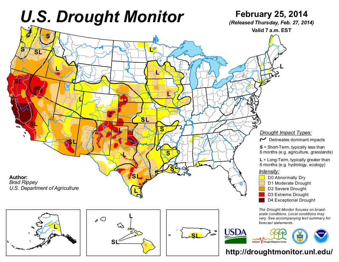
    A new agreement between Denver Water and Western Slope entities doesn’t prevent the state’s largest water utility from opposing Glenwood Springs’ proposed new recreational in-channel diversion, or RICD, water right on the Colorado River. That’s because Glenwood is seeking more water under its proposal than Denver Water agreed to go along with under the new water deal.

    Meanwhile, Glenwood also has revived the idea of a downtown whitewater park, which has revived the hot springs’ concerns about potential impacts on the springs’ aquifer.

    City officials are hopeful of being able to deal with any concerns from either Denver Water or the hot springs, and building on the success of the park already constructed on the Colorado River near the Interstate 70 interchange on the western edge of town.

    “My perception is it has been very successful,” said City Manager Jeff Hecksel.

    The big wave that forms at the park during spring runoff draws whitewater enthusiasts from all over the country, he notes.

    “It has its own following,” Hecksel said.

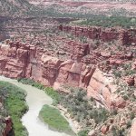
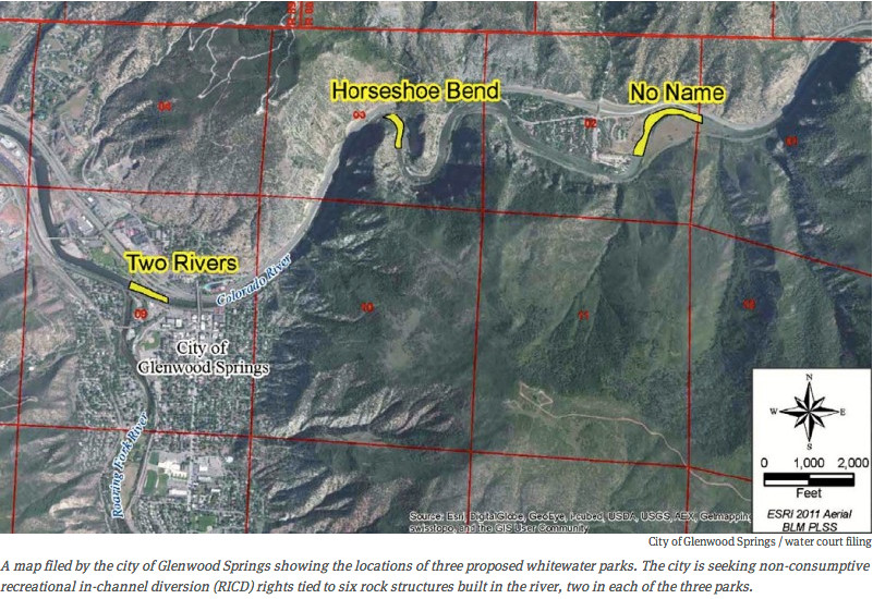
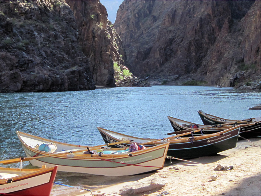
    Whitewater boating is a major part of the city’s tourism industry, with several outfitters offering guided trips in Glenwood Canyon. The city has identified several proposed locations for a new whitewater park, including the downtown location just upstream of the Roaring Fork River, the Horseshoe Bend area just west of the No Name Tunnels of I-70, and at the No Name I-70 rest area east of Glenwood Springs.

    “This is already a very actively used (river) corridor,” said Mark Hamilton, a water attorney representing the city. “I think additional whitewater features will just enhance that.”

    The city’s current park has no associated water rights. Flow there is aided year-round because it’s downstream of the Roaring Fork River and benefits from the senior water right of the Shoshone hydroelectric power plant in Glenwood Canyon.

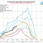
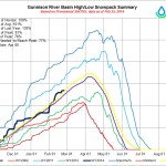
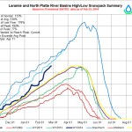
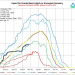
    The city is requesting a base flow of 1,250 cubic feet per second for the warmer months of the year. That’s consistent with the Shoshone right, and is an amount Denver Water specifically agreed not to oppose as part of the new water deal with the Western Slope.

    That deal was announced in 2011 and took effect last fall after resolution of some final issues. It involves more than 30 Western Slope entities, and includes provisions including the Western Slope assenting to certain Denver Water projects involving Colorado River water, and Denver Water committing to develop any further such projects only with Western Slope approval, and also committing more than $25 million to Western Slope projects.

    What complicates Glenwood Springs’ water application is that it also is seeking a higher flow of 2,500 cfs during 46 days coinciding with spring runoff, with flows of 4,000 cfs for five days within that period.

    “I think some folks may see it as not contemplated by the cooperative agreement but it doesn’t run counter to the letter of the agreement,” said Peter Fleming, who as an attorney with the Colorado River Water Conservation District was involved in negotiating that agreement. Rather, he said, it simply means Denver Water can oppose the RICD filing. He said it just will come down to negotiations, which also will entail convincing the Colorado Water Conservation Board it’s a reasonable request and won’t interfere with things such as water compact requirements.

    “I don’t think it’s going to be an enormous problem. I think there’s going to be some negotiations and some restrictions on the exercise of the RICD but there normally are,” he said.

    Consultation process

    Importantly, Fleming doesn’t consider Glenwood’s request a violation of the deal with Denver Water that could jeopardize terms such as the monetary commitment Denver Water has made to the Western Slope. That deal didn’t limit how much water the city could seek, but simply set a limit to the size of a diversion Denver Water would consent to without being able to object in water court.

    “I don’t think it imperils the cooperative agreement at all,” he said.

    Denver Water spokesman Travis Thompson confirmed that view Friday.

    “The filing of the RICD is not a violation of the (agreement). Because the filing does not meet the provisions in the (agreement), Denver Water is not required to support it as filed,” he said.

    As part of the agreement, the city agreed to consult with Denver Water regarding its application, “and through our discussions, they are aware that we will file a statement of opposition,” Thompson said.

    But he said the utility is committed to working with the city on the issue.

    Opposition statements aren’t uncommon in water cases, and aren’t necessarily intended to outright prevent approval of a water right. Rather, they can represent an attempt by an entity to be able to have a say as an application is considered in court.

    Said Thompson, “This RICD is not uncommon, as these filings often involve multiple parties who object, and then these issues are resolved during the court process.”

    The river district itself has decided to file an opposition statement.

    “From the river district’s perspective we look at the RICD both with a concern to make sure they don’t imperil water usage in the river district but also as a legitimate use,” Fleming said. “We want to make sure the Western Slope recreational economy is supported so it’s sort of a tug and pull there.”

    Hamilton said the city engaged in discussions with Denver Water for the water rights filing and those conversations continue.

    “This was not an intent to surprise anyone,” he said.

    He said the total claims are intended not to exceed half the volume of water typically available in that part of the river.

    “Presumably that leaves quite a bit of additional water in the river that could be appropriated for other purposes,” he said.

    He said most if not all of Denver’s water rights would be senior to the rights being sought.

    “If Denver already has water rights, they’re unaffected,” he said.

    Hot Springs’ aquifers

    Communities are increasingly seeking such rights in order to create whitewater parks as added recreational and tourism amenities. Carbondale recently was granted such a right and Pitkin County is seeking one. Grand County is seeking Bureau of Land Management approval related to a proposed park on the upper Colorado River in Gore Canyon, after obtaining water rights for it.

    Glenwood’s efforts over the years have been a bit more complicated by the Glenwood Hot Springs’ interests. Proponents wanted to build the first park downtown but were thwarted by the concerns raised by the springs, the city’s central tourism attraction. Kjell Mitchell, the attraction’s president and chief executive officer, said the concern is that a park could cause river-bottom scouring that could puncture shallow aquifers and affect the springs. Another concern is that a park could contribute to flooding and harm the springs. He believes the first park site turned out to be a great location for the city, and hopes it will look to the possible locations being considered farther east rather than downtown.

    “I hope if the city wants to do something that they would hopefully see the big picture and it would be a win-win situation,” he said.

    The pool sent a letter to the city outlining its concerns last year. Asked about the potential of the issue ending up in court if the city pursues the downtown location, Mitchell said, “I hope it doesn’t get to that point.”

    Hamilton and Hecksel said the proposed location is downstream of the hot springs.

    Said Hecksel, “I think it’s a matter of perception. I don’t think anybody’s going to dismiss what the concerns of the pool are, but (the proposed location) is farther downstream.”

    He said the city continues to discuss the matter with the pool.

    “The city acknowledges their concerns,” he said.

    More whitewater coverage here.

    Animas River: E.coli, nutrients, mixed authority complicate water quality picture at the Colorado/New Mexico border

    E.coli Bacterium
    E.coli Bacterium

    From The Durango Herald (Dale Rodebaugh):

    A study last year found that the level of E. coli bacteria in the Animas River just north of the New Mexico state line met water-quality standards but exceeded them in the New Mexico stretch of the river. E. coli levels in the San Juan River above its confluence with the Animas at Farmington also were above the limit.

    The E. coli limit in New Mexico for a single sample is 410 colony-forming units or a monthly average of 126 CFU, said Melissa May with the San Juan Soil and Water Conservation District. Colorado uses only the second criterium, she said. The CFU is measured by placing bacteria and an algae extract in a petri dish and counting the number of colonies.

    But the results of the survey should be considered preliminary until a follow-up study this year is completed, a report by the San Juan Watershed Group says. The new round of testing, scheduled to get underway in April and run through October, also will look at the level of nutrients – nitrogen and phosphorus – in the rivers…

    Colorado has an interim standard for nutrients, but it has been applied only on the upper reaches of the Rio Grande and Arkansas rivers, said Peter Butler a past member of the Colorado Water Quality Control Commission. In New Mexico, limits are water-body specific, May said…

    Testing was done last year at four sites, two each on the Animas and San Juan rivers, she said. BHP Billiton paid for the study, which consisted of 40 samples in all. Discrepancies in laboratory analysis of the source of E. coli require a second year of testing, May said. A different laboratory than the one used in previous years did DNA analysis in 2013, she said.

    DNA analysis can indicate if the source of E. coli is avian, ruminant (cattle, sheep, deer and elk), equine, canine or human, May said. The absence of equine samples, the low number of cattle samples and a high number of human samples call into question the sensitivity of the probes and the accuracy of overall results, the watershed group report said. Bacteria levels increased the further downstream that samples were taken, both in the San Juan and Animas rivers. The highest level of bacteria was found in the San Juan River at the Hogback Canal, the beginning of the Navajo Nation near Waterflow. Preliminary results of testing at Farmington found that fecal pathogen levels in the San Juan River exceeded the New Mexico standard. A predominant source of the pathogens was human. The finding of human pathogens was unexpected and not consistent with other studies in New Mexico, the report said…

    The Animas River is complicated because it flows through three political jurisdictions – Colorado, the Southern Ute Indian Tribe reservation and New Mexico – and numerous land uses, Ann Oliver, a spokeswoman for Animas Watershed Partnership, said. The three political jurisdictions answer to different regions of the Environmental Protection Agency, she said.

    “While preliminary data indicates a link between high E. coli from human sources in the Animas in New Mexico, this has not been documented by any study of the Animas near the state line,” Oliver said.

    More Animas River watershed coverage here and here.

    Snowpack news: Reclamation’s current forecast for Fry-Ark deliveries = 63,000 acre-feet #ColoradoRiver

    From The Pueblo Chieftain (Chris Woodka):

    The Bureau of Reclamation has estimated a banner year for Fryingpan-Arkansas flows — with a disclaimer.

    “The forecast is based on average conditions for the rest of the spring,” said Roy Vaughan, Reclamation’s manager for the Fry-Ark Project. “We’ve seen it continue to snow and rain, and we’ve seen everything stop in March.”

    Vaughan spoke at Wednesday’s meeting of the Lower Arkansas Valley Water Conservancy District.

    Based on snowpack of 140 percent of median in the Fry-Ark collection area on the other side of the Continental Divide on Feb. 1, Reclamation predicts 63,800 acre-feet of water could be imported this year. If it holds, that would be about 20 percent higher than normal. But that number could be influenced by when and how quickly the snow melts in May and June. It also depends on whether snows continue during March and April, when the mountains typically get the largest accumulation of snow.

    While the Arkansas River basin is reporting storage levels of 64 percent of average, Fry-Ark reservoirs are 85-105 percent of average for this time of year, Vaughan said. Turquoise Reservoir, near Leadville, is at 105 percent, while Twin Lakes and Pueblo are about 85 percent of average.

    Reclamation wants to move about 30,000 acre-feet of water out of Turquoise Lake, but can’t because it is making repairs on the turbines at the Mount Elbert hydroelectric plant. Most of the water moved between Turquoise and Twin Lakes goes through a large tunnel that feeds the Mount Elbert forebay. Repairs should be completed in early March, Vaughan said.

    The Southeastern Colorado Water Conservancy District will allocate water from the Fry-Ark Project in May. About 53 percent goes to cities and 47 percent to farms under the district’s allocation principles.

    From the USDA:

    Limited water supplies are predicted in many areas west of the Continental Divide, according to this year’s second forecast by the National Water and Climate Center of USDA’s Natural Resources Conservation Service (NRCS).

    Right now, snow measuring stations in California, Nevada and Oregon that currently don’t have any snow, and a full recovery isn’t likely, the center’s staff said.

    USDA is partnering with states, including those in the West, to help mitigate the severe effects of drought on agriculture.

    USDA announced last week that $15 million was available for conservation assistance to farmers and ranchers in affected areas in California, Texas, Oklahoma, Nebraska, Colorado and New Mexico. As part of the announcement, $5 million was also made available to California communities through the Emergency Watershed Protection Program. Earlier this month, USDA made another $20 million available to farmers and ranchers in California. Agriculture Secretary Vilsack joined President Obama in California on February 14th to announce those and other drought relief measures.

    Parts of eastern California are now in a state of emergency because of drought. This area is suffering one of the lowest snow years on record. Meanwhile, in Oregon, mountain snowpack is far below normal.

    “The chances of making up this deficit are so small that at this point we’re just hoping for a mediocre snowpack,” said NRCS Hydrologist Melissa Webb for Oregon. “We’d need months of record-breaking storms to return to normal. There’s a strong chance we’ll have water supply shortages across most of Oregon this summer.”

    Most Oregonians don’t have access to water from other states and depend on local sources for water supply.

    Across the Continental Divide, Montana, Wyoming and Colorado are mostly near normal. The one exception is New Mexico, which is extremely dry.

    Although NRCS’ streamflow forecasts do not predict drought, they provide information about future water supply in states where snowmelt accounts for the majority of seasonal runoff.

    NRCS has conducted snow surveys and issued regular water supply forecasts since 1935 and operates SNOTEL, a high-elevation automated system that collects snowpack and related climatic data in the western United States and Alaska. These data help farmers, ranchers, water managers, hydroelectric companies, communities and recreational users make informed, science-based decisions about future water availability.

    View February’s Snow Survey Water Supply Forecasts map or view information by state.

    Webinar: Colorado River Myths and Realities — The Coming Conflict (Brad Udall) #ColoradoRiver

    Colorado River Basin including out of basin demands -- Graphic/USBR
    Colorado River Basin including out of basin demands — Graphic/USBR

    Click here to go to the Interior website to register. Here’s the pitch:

    Colorado River Myths and Realities: The Coming Conflict
    FEBRUARY 27; 12pm Mountain
    Brad Udall, University of Colorado and SW CSC Investigator

    The Colorado River is currently in the midst of a 14-year drought nearly unrivaled in over 1250 years. The river’s two massive reservoirs, Lakes Mead and Powell, are now less than half full. Due to the drought, the Department of Interior’s Bureau of Reclamation projects that the first delivery shortages are likely to occur in two years. Further, scientists believe that climate change will reduce Colorado River runoff by 2050. Water managers also believe that water demand will increase because of increased population and warmer temperatures. The current legal system for operating this critical system is not tenable in the face of these pressures. Given that the entire American Southwest including all of its major population centers are dependent on the reliable supply of Colorado River water, what solutions in basin are likely in the near and distant future?

    HB14-1030 passes House 63-2 #COleg

    Barker Meadows Dam Construction
    Barker Meadows Dam Construction

    From The Denver Post (Hugh Johnson):

    House Bill 14-1030 mitigates the complexities of the permitting process for hydroelectric facilities that produce 10 megawatts of energy or less. Rep. Diane Mitsch Bush, D-Steamboat Springs, and Rep. Don Coram, R-Montrose, believe their bill will create more jobs in rural communities.

    Mitsch Bush said she knows a rancher living in Meeker who lowered his utility bill $10,000 a year by using hydroelectric systems.

    “It creates jobs, it increases renewables and it enables rural households to lower their electric bill,” Mitsch Bush said of the measure.

    Mitsch Bush believes the bill will make it easier for rural communities to harness the power of hydroelectric facilities by cutting some of the red tape that hinders their creation. She also said in a news release that the bill came about as a result of an inclusive stakeholder process between utilities, small hydroelectric producers, electric contractors and conservation groups.

    House Bill 1030, which passed 63-2, now goes to the Senate.

    More 2014 Colorado Legislation coverage here.

    CDOT will be working on Fountain Creek flood mitigation for a month or so #COflood

    Fountain Creek Watershed
    Fountain Creek Watershed

    From The Colorado Springs Gazette (Matt Steiner):

    Travelers using U.S. 24 west of Manitou Springs will face some severe delays over the next month as the Colorado Department of Transportation upgrades a culvert under the highway near the mouth of Waldo Canyon.

    According to CDOT spokesman Bob Wilson, the $1.4 million flood mitigation work began Wednesday. Wilson said one lane in each direction will be closed until 6 p.m. daily through Friday. Crews will work full force beginning Saturday, when CDOT will shut down both eastbound lanes around the clock. The westbound side of the divided highway will have one lane open in each direction.

    “People will have to add a little extra time for their travels,” Wilson said.

    According to Wilson, the eastbound lanes will be closed for about two weeks. Once the culvert is installed under that side of the highway, the project will shift and the westbound lanes will be closed.

    Wilson said CDOT will install a 24-foot wide and 10-foot high culvert that will be “10 times larger than the pipe that’s under the highway right now.” He said the current 72-inch pipe is a choke point when heavy rains hit the more than 18,000 acre Waldo Canyon burn area. The fire that began June 23, 2012, destroyed 347 homes in western Colorado Springs and killed two people.

    CDOT estimates the culvert project will be finished by the end of April.

    More Arkansas River Basin coverage here and here.

    Eighteen Conservation Groups Give Gov. Hickenlooper Input on State Water Plan #COWaterPlan

    Colorado Water Plan website screen shot November 1, 2013
    Colorado Water Plan website screen shot November 1, 2013

    Here’s the release from Earth Justice:

    Today, eighteen Colorado conservation and citizen groups sent a letter to Governor John Hickenlooper with recommendations for the Colorado Water Plan. The local, regional, and statewide groups pointed out that the Governor’s Executive Order creating the Water Plan called for “Healthy Watersheds, Rivers and Streams, and Wildlife,” and asked the Governor to prioritize these values in the Plan…

    The groups’ recommendations include three “actions” for the Plan to implement:

  • Focus on “Healthy Alternative Water Supplies” including conservation and other measures that are cheaper, faster, and easier to implement.
  • Do not support any new diversions from Colorado’s rivers.
  • Prioritize river restoration.
  • “This is the time to act,” said McCrystie Adams, staff attorney at Earthjustice. “River flows are expected to plunge in the coming years as our climate grows warmer and the mountain snowpack is disrupted. What will happen to our rivers and the life they support if we are already diverting all of the flows that we physically can?”

    The groups’ letter highlights that seven extremely controversial projects are going through state and federal permitting processes, including the Halligan Project, Seaman Project, Bellvue Pipeline, Northern Integrated Supply Project, Windy Gap Firming Project, Moffat Project, and Chatfield Project.

    The groups recommend that these projects be put “on hold” and that “Healthy Alternatives” be prepared that don’t divert more water out of Colorado’s rivers. The groups also point out that some of the participants in these projects are selling increasing amounts of water for fracking which is further degrading Colorado’s rivers.

    One of the projects, Denver Water’s “Moffat Collection System Project,” is scheduled to have its “Final Environmental Impact Statement” released in April. The groups are especially concerned about the Moffat Project.

    “With so much of our clean, treated, drinking water being sprayed on non-native grass in a semi-arid climate, the opportunity for tremendous advances in meeting future supply needs through simple conservation seems a no-brainer,” said Chris Garre of The Environmental Group which is addressing the threat of the Moffat Project. “Nevertheless, Denver Water is proposing to divert still more water off the Fraser River—85% of its natural flows—effectively killing the river.”

    The groups are responding to a call for input by the Governor, Colorado Water Conservation Board, and Interbasin Compact Committee. The Water Plan is supposed to be “grassroots” and “bottom up.” By focusing on these citizen groups’ recommendations, which represent tens-of-thousands of Coloradans, the State Water Plan can protect and restore Colorado’s rivers and meet the needs of local communities.

    Groups signing the letter include Citizens for a Healthy Fort Collins, Clean Energy Action, Clean Water Action, Earthjustice, Earth Works Action, Environment Colorado, Frack Free Colorado, Fractivist.com, Plains Alliance for Clean Air and Water, Rocky Mountain Wild, San Juan Citizens Alliance, Save Chatfield, Save The Colorado River Campaign, Save The Poudre: Poudre Waterkeeper, Sheep Mountain Alliance, Sierra Club – Poudre Canyon Group, The Environmental Group of Colorado, and WildEarth Guardians.

    More Colorado Water Plan coverage here.

    AWRA: Water Policy is No Longer a Luxury for the United States

    Projected supply gap for 2030 via the Colorado Water Conservation Board
    Projected supply gap for 2030 via the Colorado Water Conservation Board

    Here’s the release from the American Water Resources Association via PRWeb:

    In celebration of its 50th anniversary, the American Water Resources Association (AWRA) is offering free downloads of the January issue of Water Resources IMPACT Magazine featuring articles on The Future of Water Resources in the United States.

    “Water policy is no longer a luxury for the United States; we cannot continue the theatrical spectacle in which academics and water professionals bemoan our lack of progress to be met by the stony silence of political leaders,” writes Denise Fort, Environmental Lawyer and Research Professor of Law, University of New Mexico.

    With cries of a looming U.S. water crisis grabbing headlines daily, Fort gets right to the point in her article ‘The Future is Here: The Nation Can No Longer Avoid Its Water Challenges.’ While her fellow authors may not be so blunt, they don’t disagree.

    “The challenge is to move governments away from simply responding to crises to a more proactive approach that identifies the populations, sectors, and regions most at risk and targets programs to those areas with the goal of reducing the risk,” writes Donald A. Wilhite, Founder, National Drought Mitigation Center, University of Nebraska, in his article ‘Changing the Paradigm for Drought Management: Can We Break the Hydro-Illogical Cycle?’

    Already being lauded for its integrated approach and national relevance, the January 2014 issue of Water Resources IMPACT addresses many of the challenges currently facing U.S. water resources managers, including climate change, population shifts, drought, flooding, law, infrastructure, contaminants, agricultural use and economics.

    “Nineteen prominent non-federal water resources professionals from across the United States…were invited to provide essays,” writes Richard Engberg, Guest Editor, in his introduction of the issue. “These writers responded with a remarkable group of essays [that] contain much food for thought, and I believe they will influence the course of water resources over the rest of the first half of the 21st century.”

    While approaching water resources management issues from vastly different backgrounds and with varied approaches, all seem to, again, come to the conclusion reached by Fort in the final lines of her article, “We…actually seem to be in broad agreement about what good water policies are, perhaps with the luxury of so many out years to contemplate them. When policy makers are ready to engage, they will find a wealth of ideas awaiting them.”

    We at AWRA agree, which is why we are providing this issue of Water Resources IMPACT as a free download for anyone with an interest in the successful management of our nation’s water resources. Read it. Circulate it. Discuss it. Then, share your thoughts and ideas with us at #USWaterFuture.

    Tipton: Vital Water Storage Projects Impeded by Federal Red Tape

    Northern Integrated Supply Project via The Denver Post
    Northern Integrated Supply Project via The Denver Post

    Here’s the release from US Representative Scott Tipton’s office:

    Today [February 5, 2014], in a House Natural Resources Water and Power Subcommittee hearing, Congressman Scott Tipton (R-CO) stressed that federal red tape is blocking needed water storage projects, impeding prudent supply management, and jeopardizing agriculture production, environmental protection and flood control.

    “The importance of prudent water supply management in Colorado for economic and environmental benefits cannot be overstated,” said Tipton. “The ability to store water—the most precious resource in the Western U.S.—enables communities to meet environmental protection needs, support jobs that depend on the availability of water, ensure our food supply, control flooding, afford continued recreational opportunities, and provide water for the development of clean, renewable hydropower. The onerous and duplicative federal permitting process is blocking the construction of needed storage projects and creating unnecessary threats to our water supplies. The Water Supply Permitting Coordination Act would clear up some of these duplicative regulatory hurdles by establishing a coordinated permitting process, significantly reducing the time and cost of building these needed projects.”

    In an October 2013 hearing on water storage, Tipton underscored that with the exception of the Animas-La Plata project in Southwestern Colorado, the Bureau of Reclamation has not built any large multi-purpose dams or reservoirs over the last generation. Without new water storage and continued conservation as many as 700,000 acres of agriculture land could dry up in Colorado by 2050 due to urbanization and urban water transfers.

    During today’s hearing, Patrick O’Toole, president of Family Farm Alliance, with farming operations in the 3rd District, testified on the extreme length of the federal permitting process for water storage projects.

    “As you are all aware, actually developing new storage projects is much easier said than done. I testified before this Subcommittee two years ago about the permitting challenges I encountered in building the Little Snake Supplemental Irrigation Supply Project (High Savery Project) in Wyoming. That project was built in less than two years, but took more than 14 years to permit,” said O’Toole. “My experience with the High Savery Project showed me that cooperative efforts are important for moving projects through the National Environmental Policy Act (NEPA) and other permitting processes. On the High Savery Project, the lead federal agency wasted a great deal of time making decisions on the project and at times seemed unable to make decisions. These delays not only postponed the project, they resulted in wasted time and money.”

    Read O’Toole’s full testimony here.

    H.R. 3980, The Water Supply Permitting Coordination Act, would establish a “one-stop-shop” permitting process through the Bureau of Reclamation, rather than requiring projects to undergo numerous duplicative and lengthy environmental reviews separately. The idea of a coordinated permitting process has received bipartisan support. By coordinating the permitting process, H.R. 3980 would expedite needed water storage projects without sacrificing responsible environmental review of those projects.

    “The administration has already acknowledged the benefit of coordinated agency review in several contexts including large scale transmission projects,” said Tipton. “It’s time we move forward in a bipartisan way to implement coordinated review for the development of increased water supplies for American farms, communities and families.”

    Say hello to High Desert Dories: ‘Dories are the inverse of rafts’ — Andy Hutchinson

    Photo via High Desert Dories

    From the Cortez Journal (Jim Mimiaga):

    An eclectic gang of river runners, Grand Canyon guides, and boating purists take refuge in Dolores during the winter off-season.The amicable group never strays too far from their coveted rivers, skiing backcountry powder that will soon transform into whitewater rapids, and then quaffing pints of craft beer made from the same water at the Dolores River Brewery.

    In between, they gather for thousands of hours to talk rivers, play bluegrass, and build custom boats in the shop of local legend Andy Hutchinson, owner of High Desert Dories.

    A master craftsman and Grand Canyon guide, Hutchinson’s humble and casual demeanor masks his enthusiastic life passion for building custom dories and piloting them through river country.

    “In 1982, I was on a beach at Nankoweap Canyon when I first saw a flotilla of these classic boats coming down the Colorado River,” Hutchinson, 57, recalls. “It was like the heavens called down to me, and I’ve been obsessed ever since.”

    Dories are wooden oar boats originally used on the great rivers of the West by pioneers including Civil war veteran John Wesley Powell, who completed the first-ever trip down the rapid-choked Grand Canyon rowing a dory in 1869.

    Replaced by less aesthetic plastic and rubber rafts that are more forgiving against river rocks, but also more cumbersome, dories fell out of mainstream favor in the 1970s.

    But the dory’s classic rocker shape, turn-on-a-dime maneuverability, and ample waterproof storage compartments always stayed popular for the old-school crowd, and today they are attracting more converts.

    “Dories are the inverse of rafts, so they turn easily with a stroke of the oar, but they do not bounce of rocks very well, so you carry a good-size repair kit, or better yet miss the rocks!” Hutchinson said. “What’s nice too is that they’re like giant coolers with lots of compartments to take everything along.”

    More whitewater coverage here.

    USGS: Characterization of Hydrodynamic and Sediment Conditions in the Lower Yampa River at Deerlodge Park, East Entrance to Dinosaur National Monument, Northwest Colorado, 2011

    Yampa/White/Green river basins via the Colorado Geological Survey
    Yampa/White/Green river basins via the Colorado Geological Survey

    Here’s the abstract from the USGS (Cory A. Williams):

    The Yampa River in northwestern Colorado is the largest, relatively unregulated river system in the upper Colorado River Basin. Water from the Yampa River Basin continues to be sought for a number of municipal, industrial, and energy uses. It is anticipated that future water development within the Yampa River Basin above the amount of water development identified under the Upper Colorado River Endangered Fish Recovery Implementation Program and the Programmatic Biological Opinion may require additional analysis in order to understand the effects on habitat and river function. Water development in the Yampa River Basin could alter the streamflow regime and, consequently, could lead to changes in the transport and storage of sediment in the Yampa River at Deerlodge Park. These changes could affect the physical form of the reach and may impact aquatic and riparian habitat in and downstream from Deerlodge Park.

    The U.S. Geological Survey, in cooperation with the Colorado Water Conservation Board, began a study in 2011 to characterize the current hydrodynamic and sediment-transport conditions for a 2-kilometer reach of the Yampa River in Deerlodge Park. Characterization of channel conditions in the Deerlodge Park reach was completed through topographic surveying, grain-size analysis of streambed sediment, and characterization of streamflow properties. This characterization provides (1) a basis for comparisons of current stream functions (channel geometry, sediment transport, and stream hydraulics) to future conditions and (2) a dataset that can be used to assess channel response to streamflow alteration scenarios indicated from computer modeling of streamflow and sediment-transport conditions.

    More USGS coverage here.

    Conversation with James Newberry (Colorado River District @ColoradoWater) via Sky-Hi Daily News #ColoradoRiver

    Colorado Water Plan website screen shot November 1, 2013
    Colorado Water Plan website screen shot November 1, 2013

    From the Sky-Hi Daily News (Leia Larsen):

    James Newberry is starting his second year as the Colorado River District board president, and has represented Grand County on the board since 2004. Through his time on the board and serving as a county commissioner, Newberry has made protecting the area’s valuable water resources a high priority.

    Chief among water concerns are developing Colorado’s first water plan, which is currently being drafted, and obligations from the 1922 Colorado River Compact. As drought menaces water supplies in downstream states, those obligations could spell trouble for those living at the Colorado River’s headwaters in Grand County. Newberry spoke about the challenges facing the state’s water supply and thoughts about our water future.

    What are you goals as president of the Colorado River District board for the coming year?

    I don’t know it’s a goal, but what’s been laid out in front of us is the Colorado water plan, and we as a district have been involved in formulation of that plan. We’re also looking into compact calls to lower basin states, and how that integrates into the Colorado water plan. For example, how do we match up being able to divide up water on the East and West slopes within Colorado, while still managing those compact agreements? I think the Colorado River District will be a leader in advocating for different methods, such as water banking and risk-management in the different river basins. Statewide, we’re looking at what it means to develop a water plan while meeting a compact call, should it go into place. As a river district, we don’t believe it’s just a West Slope issue.

    Explain the problems Grand County could face from drought issues farther downstream.

    That truly is the problem with a compact call. The only water rights that wouldn’t be subjected to a compact call are those made before 1922, the very senior water rights. Some people say if we get compact calls it’s great for Grand County, because not as much water will go to the Front Range as we send it down river to meet our obligations. But there are going to be a lot of junior rights that people wouldn’t be able to use.

    The bottom line is, it works in all water users’ interests to work on a water plan. That way if there is a call, we’ll have water stored up or credited, and we can work out those preexisting diversions.

    One thing the Colorado River District is fighting for is to make sure whatever the risk of that future that call is, it’s not just going to be the West Slope bearing the brunt of meeting compact obligations downstream.

    The West’s water future is looking grim. Is there anything that makes you feel optimistic?

    We’re now taking a hard look at the water situation we’ll have in the future. When they decided the Colorado River Compact, it was one of the wettest periods in the history of the Colorado River. I don’t think that model is viable. Whether you believe in climate change and its effects or not, maybe this is making us aware of the amount of water we really do have, and it’s getting us to do a better job of managing it. Is that optimism? Maybe not, but it’s the reality we’re facing.

    What projects are you advocating to increase conservation of Colorado River water?

    We’re always looking at ways of conservation. In the next 30 years or so, the state projects we’re going to have a 500,000-acre-foot water shortage. One of our engineers looked at the study (the Statewide Water Supply Initiative 2010), then turned around and said we could address that gap without further diversions from the West Slope, some of that through conservation. There is no ‘new water,’ and we’ll have to go back to conservation, like installing low-flow faucets and lining irrigating ditches. We’re always backing ways to better use water we have.

    Are there any accomplishments you’re proud of during your time on the Colorado River District board?

    I think the involvement with the Windy Gap firming project in Grand County. Without the river district, I don’t know how far we would’ve gotten back at the federal level and the Bureau of Reclamation, the heavy hitters, without their help.

    The Colorado River District has also been heavily involved in Vail Ditch water shares and trying to move water to the upper Fraser River. And they’ve done a huge amount of work on the Colorado River here. The river district basically came into existence to be a watchdog on the Colorado-Big Thompson project. That’s truly the root of their existence, and we have held true to that. For example, we’re working on water clarity in Grand Lake, and the river district is helping hand-in-hand.

    More Colorado River Water Conservancy District coverage here.

    The drying of the West — The Economist #ColoradoRiver

    US Drought Monitor February 18, 2014
    US Drought Monitor February 18, 2014

    Click here to read the whole article. Here’s an excerpt:

    On January 17th Governor Jerry Brown urged Californians to cut water use by 20% and issued a drought declaration, which loosens the rules restricting in-state water transfers. Last week Barack Obama visited Fresno, in California’s fecund Central Valley, to announce $183m of federal aid before spending three days golfing on well-watered courses in the desert. This week California’s leaders pledged a further $687m in drought relief…

    Drought is also afflicting California’s neighbours to the east (see map). But they, along with California, are grappling with a longer-term problem: the Colorado river, which waters seven states (plus part of Mexico), is struggling to service its clients. Thanks to declining flows, last year the Federal Bureau of Reclamation (FBR), which oversees its use, cut the release of water from Lake Powell on the Arizona-Utah border to Lake Mead, America’s largest reservoir. It has never done this before…

    Traditionally the West has tried to engineer its way out of water problems, and that approach is not dead in Nevada. Greater Las Vegas, where most Nevadans live, depends on Lake Mead for 90% of its water, but before long the lake is expected to fall below the level of the first of two pipes that connect it to the city. So officials are building a deeper $816m “third straw” to maintain supply. They also want to lay a 300-mile pipeline to bring water from Nevada’s sparsely populated north to Las Vegas, a controversial plan some compare to Los Angeles’s removal of water from the Owens Valley 100 years ago (as fictionalised in Roman Polanski’s “Chinatown”)…

    Douglas Kenney of the University of Colorado Law School predicts “a new era” of water management. One still occasionally hears grand talk of transporting water from the Missouri river, or of ferrying icebergs from Alaska, but these pipe dreams are giving way to a focus on conservation and reform. Thanks to careful planning by water authorities many cities in the West have slashed per-capita water use; in the past 12 years Las Vegas has cut consumption by one-third as its population grew by a fifth. Its successful “cash-for-grass” programme (since renamed after grumbles from the Drug Enforcement Administration), which pays residents to tear up lawns, has been imitated elsewhere. All water used indoors is recycled.

    But more can be done, says Michael Cohen at the Pacific Institute, a think-tank. Cities in dry places like Israel and Australia still consume far less water than Las Vegas. Other cities in the West have a long way to go: half the houses in Sacramento do not meter water; Palm Springs, close to where Mr Obama teed off this weekend, still peddles the old illusions of desert verdancy. As for water trading, it is underdeveloped within states, let alone between them.

    Most of the future growth in water demand is likely to come from cities. Some therefore argue that urbanites should bear the burden of reducing demand. This is too kind to farmers, who waste far more. Crops that cannot be grown without subsidies should not be grown. It should not take a drought to make people stop building paddy fields in the sand.

    More Colorado River Basin coverage here and here.

    Drought news: California is in a world of hurt #ColoradoRiver

    From the post:

    Two water districts in Southern California will spend a total of $US 80 million this year to tear out lawns, replace inefficient toilets, and purchase more water imported from the Colorado River, a distant source that itself is in a 14-year dry spell.

    Farther north, a district east of Sacramento, in an attempt to cut water consumption by 40 percent, is considering a dramatic rate increase for the heaviest users.

    Taken together, the economic responses to the drought reveal two consequences: that the price of water will rise to pay for these programs and that this drought, if it continues much longer, will test the financial stability of many municipal water systems, which are tapping reserves and face higher prices for water delivered by state and federal canals.

    “In a prolonged drought, a simultaneous increase in water prices and reduction in usage would put import-dependent utilities under pressure, forcing large and difficult-to-impose rate increases,” claims Fitch Ratings, a credit rating agency.