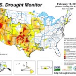
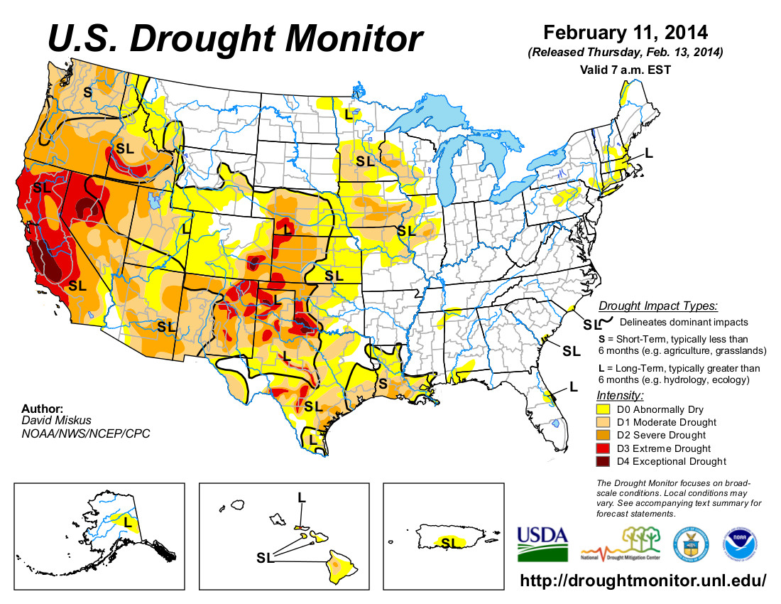
Colorado submits $62.8 million flood recovery plan to HUD

Plume of subtropical moisture streaming into Colorado September 2013 via Weather5280

Here’s the release from Governor Hickenlooper’s office:

Gov. John Hickenlooper submitted today the Community Development Block Grant – Disaster Recovery (CDBG-DR) Partial Action Plan to the U.S. Department of Housing and Urban Development.

The State must submit the Partial Action Plan before receiving the $62.8 million in CDBG-DR Funds that HUD allocated to flood impacted communities in Colorado. The money will go toward needs not addressed through other sources of federal assistance, such as the Federal Emergency Management Agency (FEMA).

“We are submitting our action plan 30 days in advance of our deadline in an effort to expedite the money coming to Colorado,” Hickenlooper said. “The CDBG-DR funds are critical to the recovery effort. Our Action Plan will allow homeowners, businesses and communities to prioritize their unmet needs and apply to the State based on those community priorities.”

Colorado’s CDBG-DR Partial Action Plan provides for grant and loan programs that will be available to flood impacted communities in housing, infrastructure and economic development. The initial allocation of the $62.8 million was announced during a December 2013 visit to Colorado from HUD Secretary Shaun Donovan.

In a letter to Donovan, Hickenlooper thanked him and the Colorado Congressional Delegation for their “partnership and leadership” in bringing these important disaster recovery funds to Colorado. Hickenlooper acknowledged in the letter the public’s valuable feedback incorporated into the Partial Action Plan, “Coloradans are resilient and their commitment to building back stronger and better is reflected in this Action Plan.”

HUD requires that 50 percent of the CDBG-DR funds benefit low- to moderate-income households and that 80 percent of the funds be distributed in Boulder, Larimer and Weld counties. The remaining 20 percent can be distributed among the other 11 counties in the September Presidential Declaration.
HUD has up to 45 days to approve Colorado’s Initial Partial Action Plan, making funds available sometime in April. The Partial Action Plan, eligibility requirements and the application process for these funds can be found online at http://dola.colorado.gov/cdbg-dr.

Regression Models for Estimating Salinity and Selenium Concentrations at Selected Sites in the Upper #ColoradoRiver Basin, Colorado, 2009–2012

Study area in western Colorado

Here’s the abstract from the USGS (Joshua I. Linard/Keelin R. Schaffrath):

Elevated concentrations of salinity and selenium in the tributaries and main-stem reaches of the Colorado River are a water-quality concern and have been the focus of remediation efforts for many years. Land-management practices with the objective of limiting the amount of salt and selenium that reaches the stream have focused on improving the methods by which irrigation water is conveyed and distributed. Federal land managers implement improvements in accordance with the Colorado River Basin Salinity Control Act of 1974, which directs Federal land managers to enhance and protect the quality of water available in the Colorado River. In an effort to assist in evaluating and mitigating the detrimental effects of salinity and selenium, the U.S. Geological Survey, in cooperation with the Bureau of Reclamation, the Colorado River Water Resources District, and the Bureau of Land Management, analyzed salinity and selenium data collected at sites to develop regression models. The study area and sites are on the Colorado River or in one of three small basins in Western Colorado: the White River Basin, the Lower Gunnison River Basin, and the Dolores River Basin. By using data collected from water years 2009 through 2011, regression models able to estimate concentrations were developed for salinity at six sites and selenium at six sites. At a minimum, data from discrete measurement of salinity or selenium concentration, streamflow, and specific conductance at each of the sites were needed for model development. Comparison of the Adjusted R2 and standard error statistics of the two salinity models developed at each site indicated the models using specific conductance as the explanatory variable performed better than those using streamflow. The addition of multiple explanatory variables improved the ability to estimate selenium concentration at several sites compared with use of solely streamflow or specific conductance. The error associated with the log-transformed salinity and selenium estimates is consistent in log space; however, when the estimates are transformed into non-log values, the error increases as the estimates decrease. Continuous streamflow and specific conductance data collected at study sites provide the means to examine temporal variability in constituent concentration and load. The regression models can estimate continuous concentrations or loads on the basis of continuous specific conductance or streamflow data. Similar estimates are available for other sites at the USGS National Real-Time Water Quality Web page (http://nrtwq.usgs.gov) and provide water-resource managers with a means of improving their general understanding of how constituent concentration or load can change annually, seasonally, or in real time.

More USGS coverage here.

Hydraulic fracturing: ‘It really is just water and sands that goes down a hole’ — William Fronczak

The hydraulic fracturing water cycle via Western Resource Advocates

From The Fort Morgan Times (Rachel Alexander):

He said the fluid used in the hydraulic fracking, as it is called, process is 99 percent water and sand, with only a small percentage being added chemicals.

“It really is just water and sands that goes down a hole,” Fronczak said.

He said vertical fracking uses between 375,000 and 410,000 gallons of water while the more frequently used horizontal fracking uses between 2 and 4 million gallons.

“There’s a lot of logistics handling water,” he said. “We don’t want to shut down a frack due to water.”

Fronczak used a variety of charts to show the association members how the actual fracking is only a small portion of what is done with the industry’s water. Initially, water has to be sourced, then transported or transferred to the fracking site. After it is brought out of the fracking hole, the water has to be contained and treated.

“The challenge is meeting that high rate of demand in a short period of time,” Fronczak said.

He discussed the limitations of trucking water to fracking sites and the use of piping to transfer the water over distances. This also allows the industry to decrease its carbon footprint.

“Where there’s a lot of activity, there’s not a lot water,” he said, adding that industry members have work to find solutions to the water issue. “Closest water isn’t always the best. From a quality standpoint as well as from a logistical standpoint.”

More oil and gas coverage here and here.

SB14-017 amended: ‘No matter where you stand on this bill, you might want to contemplate what the future of Colorado is’ — Sen. Ellen Roberts #COleg

Senator Ellen Roberts

From The Durango Herald (Joe Hanel):

Sen. Ellen Roberts, R-Durango, guaranteed that outcome [no legislative lawn limits this session] Friday when she changed her bill to limit lawn sizes into a study to be conducted this summer by the Legislature’s water committee.

Roberts had been promoting an idea by Durango water engineer Steve Harris, who proposed limiting new lawns to 15 percent of a lot if the subdivision used water converted from agricultural use. Western Slope water conservation districts got behind the idea after years of watching farms dry up when farmers sell their water rights to cities.

“No matter where you stand on this bill, you might want to contemplate what the future of Colorado is,” Roberts told senators Friday…

Roberts said she wasn’t attacking lawns, and she’s not trying to turn the Front Range into Phoenix or Las Vegas, where some lawns are not allowed. But she wants homeowners to use more water-efficient plants and create a “Colorado landscape.”

“It’s a landscape in our front yards that actually matches our topography and our climate,” Roberts said.

From the Associated Press (Kristen Wyatt) via the Fort Collins Coloradoan:

…Roberts ran into opposition from her own party. Other Republicans said the lawn limit idea was too heavy-handed on local governments, which control zoning and local land use. And some argued the bill improperly targeted residential water use but not agricultural water use.

“Why are we just attacking our green lawns?” asked Sen. Scott Renfroe, R-Greeley.

The Senate amended the bill and decided to study the lawn problem instead, sending the question to a committee of 10 state lawmakers that reviews water policy and suggests new laws. The Colorado Water Conservation Board won’t look at the 15 percent limit, but would instead be broadly instructed to look at residential and municipal water use.

The bill awaits a more formal vote in the Senate before it heads to the House.

Even in its weaker form, it sparked a lively debate among both parties about how boldly Colorado needs to address drought, water use and population growth.

Sen. Vicki Marble, a Fort Collins Republican, said Colorado needs to build more water storage, not limits on household lawns.

“We can restrict ourselves into oblivion and the greatest Dust Bowl we’ve ever seen,” Marble said.

Roberts said the bill would have set the first statewide lawn limit of its kind anywhere in the nation. Some municipalities already limit lawns, and the water district serving San Antonio, Texas, last year offered homeowners $100 vouchers in exchange of removing at least 200 square feet of lawn.

More 2014 Colorado legislation coverage here.

La Junta: The 20th Annual Arkansas River Basin Water Forum, April 22-24

Arkansas River Basin -- Graphic via the Colorado Geological Survey
Arkansas River Basin — Graphic via the Colorado Geological Survey

Click here to go to the forum website for all the details.

From the Lamar Ledger:

Nominations are now being accepted for the 10th Annual “Bob Appel -Friend of the Arkansas” Award; presented each year at the Arkansas River Basin Water Forum meeting.

The award is designed to honor an individual who has over the years demonstrated their commitment to improving the condition of the Arkansas River as it flows from its headwaters near Leadville to the Colo. state line.

The award is meant to recognize someone who has helped to promote the best management practices in the usage of water in the Arkansas River basin. Their efforts may include contributions in the general areas of development, preservation, conservation and/or leadership. The ability to reach out to as many constituents as possible, and cooperation and consensus building, is an important aspect in the consideration of this award.

Other considerations include, but are not limited to the nominee’s length of service in the area of water resources, the impact of their accomplishments, and their respect within the water community of the Arkansas River basin.

Nominations should include a thorough description of why the individual is being nominated as well as any testimonials or letters of recommendation.

Nominations may be sent to Jean Van Pelt at Southeastern Colorado Water Conservancy District 31717 United Ave. Pueblo, Colo. 81001, e-mail – jean@secwcd.com, fax – 719-948-0036.

Nominations need to be received no later than Friday, March 21, 2014. If you have any questions about the award or the nomination process, please email or call Jean at 719-948-2023.

The Forum will be held on April 23 and 24, 2014 at Otero Junior College, in La Junta, Colo. Forum information is available at arbwf.org.

More Arkansas River Basin coverage here and here.

Snowpack/Drought news: (% of normal): South Platte =142%, Upper Rio Grande = 83% #COdrought

From The Pueblo Chieftain (Chris Woodka):

Despite recent moisture, Southern Colorado still is struggling with the impacts of prolonged drought. Clouds of dust continue to roll across the prairies, bringing piles of tumbleweeds with them. Miles of roads are lined with the weeds and sometimes clogged by them.

“We’ve had 45 miles of roads impacted by tumbleweeds, and have even had to keep some closed when they became impassable,” said Crowley County Commissioner Frank Grant.

Crowley County has spent at least $75,000, used snowplows and purchased a forage chopper to clear roads since late October when the tumbleweeds began appearing.

“It’s a lot like herding balloons. You push them off, and they keep coming back,” Grant said. “Pueblo County road crews have been hitting it hard, too.”

Area soil conservation districts have applied for grants to purchase equipment. Canal companies are dealing with miles of tumbleweeds plugging up ditches in prepara­tion for water that will begin flowing in less than a month. And some homeowners in rural areas have had trouble reaching or leaving their homes.

“Every time the wind blows, you see them pile up,” said J.D. Wright, who lives in eastern Pueblo County on the Crowley County line about 15 miles north of Colorado 96. “This is a very serious situation. It’s nobody’s fault, just a matter of dealing with the tumbleweeds.”

The weeds have damaged rangeland because they break off more beneficial grasses as they roll across the ground.

“The sandhills in the Hanover-Boone area that have been stable for the last 50 years are beginning to blow,” Wright said.

From Steamboat Today (Tom Ross):

After 3.1 inches of fresh snow was recorded in town Thursday morning, the snowfall total for October 2013 through February to date was 165.6 inches, according to the regional climate center of the National Oceanic and Atmospheric Administration. That compares to the full-season average (1981 through 2011) of 169.7 inches. And there’s likely more on the way…

Season-long snowfall in town always is significantly lower than it is at midmountain at Steamboat Ski Area. And this winter is no different, with the ski area reporting 279 inches for the season thus far…

Monthly snowfall in the city of Steamboat consistently has been above average this fall and winter, with 16.8 inches in October, 27.9 inches in November, 38.3 inches in December, 52.2 inches in January and 30.4 inches as of Thursday for February.

The #ColoradoRiver Basin Roundtable is soliciting input for the #COWaterPlan

Colorado Water Plan website screen shot November 1, 2013

From the Glenwood Springs Post Independent (Hannah Holm):

A looming water shortage for Front Range cities is largely driving current efforts to develop a Colorado Water Plan, but that doesn’t mean that towns and cities on the Western Slope are entirely prepared for their own water future.

According to Louis Meyer of the consulting firm SGM, most water providers that serve households in communities from the Colorado River’s headwaters in Grand and Summit Counties on down to Grand Junction have done a pretty good job of planning for the range of climate conditions that have been seen over the past several decades. However, most are not prepared for the more extreme droughts that both climate change models and ancient tree ring studies indicate could occur in the future.

SGM is working with the Colorado Basin Roundtable to assess water needs and potential projects for a “Basin Implementation Plan” that will help inform the Colorado Water Plan that Governor Hickenlooper wants drafted by the end of this year. The Colorado Basin Roundtable, like its counterparts in other major river basins around the state, is a group of water managers and stakeholders charged by the state legislature with doing “bottom-up” water planning. Meyer and his team have been interviewing domestic water providers throughout the river basin to determine what their needs are and what kinds of projects would help them be more prepared for the future.

One factor making communities vulnerable to prolonged or extreme droughts is the fact that many lack sufficient reservoir storage upstream from their water treatment plants. These communities rely largely on water in streams to serve their customers while releasing water from reservoirs in other drainages to satisfy any downstream senior calls on the river. This is more of an issue in headwaters communities in the upper Fraser, Eagle, Blue and Roaring Fork than in the Grand Junction area, where water providers enjoy access to reservoirs that are physically, as well as legally, upstream.

Today’s regulatory and permitting requirements for reservoirs have resulted in planning horizons which can take longer than 20 years. Permitting costs can exceed many millions of dollars with no assurance that reservoirs can even be permitted. Both in order to ease permitting and to respond to increasing competition for water between different user groups, Meyer argues that, “reservoirs of the future must provide multiple benefits to provide water for safe drinking water, agricultural irrigation and water to provide in-stream flows to protect environmental and recreational needs.”

Another challenge for water providers attempting to plan for the future is the wild card of population growth. This region is expected to grow at the fastest rate in the state, and much of that growth could occur outside of established municipalities. In unincorporated areas, water supplies tend to be less developed and secure. Increasing conservation is one way to reduce the impact of population growth, and many water providers have strong conservation programs, but there is a lack of consistency in these efforts across the basin.

Forest health is also important to many Colorado Basin water providers. While having intakes high up in pristine tributaries has great benefits in terms of water quality, it also means that a catastrophic wildfire in a source watershed could be particularly devastating.

Increasing reservoir storage, promoting conservation and addressing forest health all require money, and increasing storage requires permits as well. The small size of many water providers in the basin limits their capacity to take on big projects, so Meyer and his team have suggested more regional cooperation may make projects to increase the reliability of community water supplies more feasible.

Water customers also have a role to play in determining the capacity of their water utility to plan and prepare for the future. If customers are not willing to help pay the necessary costs through their rates, it limits a utility’s capacity to act. Water providers are not only faced with providing safe drinking water to customers at prices that are often less than 1/10th of one penny per gallon, but now customers are much more aware of water demand impacts on local stream health.

How do you think water utilities should prepare for the future, and what are you willing to pay for?

To let the Colorado Basin Roundtable know your thoughts, answer a quick survey by clicking on this link: http://www.surveymonkey.com/s/CommunityWater.

To learn more about the Colorado Basin and statewide water planning processes, go to http://www.coloradobip.sgm-inc.com.

More Colorado Water Plan coverage here.

‘…if the system [#ColoradoRiver] crashes, there will be no winners’ — Pat Mulroy

Colorado River Basin including out of basin demands -- Graphic/USBR
Colorado River Basin including out of basin demands — Graphic/USBR

From the Palm Springs Desert-Sun (Ian James):

She noted that water levels in Lake Mead are expected to drop more than 20 feet this year, and she predicted that while the Rocky Mountains now have a bit more than their normal amount of snowpack, the Colorado River will face growing stresses in the future. Those stresses have been compounded this year by California’s record drought.

“It is an interconnected web. You cannot push on one end of it without seeing the consequences on the other end,” Mulroy said. She added that the Metropolitan Water District of Southern California, which provides drinking water to nearly 19 million people, has no choice but to take water out of Lake Mead.

“And the rest of us in that basin cannot start screaming. We can’t be parochial. We can’t sit in Las Vegas and wring our hands and say, ‘Oh my heavens, the lake’s going to drop even further,’ ” Mulroy said. “There is great strength in that interdependence because there is a shared stewardship of the system.”

She said that’s a sharp contrast from the past, when battles over water rights often have been fought in court.

“What we never think of ourselves as is that we are citizens of a water system. We never look at it as a larger system,” Mulroy said. “We have to, as the water community, silence the strident voices. If we don’t silence the strident voices, this can spin out of control real quickly.”

“We’re telling the community there (in Las Vegas), if the system crashes, there will be no winners,” she added. “If the system crashes, everybody crashes, and it doesn’t matter where you are on that system, so protecting that system is all-important, and understanding our role as a citizen of that basin and of that water system is going to be enormous for us. It is a real mind shift.”[…]

“The time has never been more critical than now,” Mulroy said in an interview after her speech. “I’m a big believer that the future is about being very flexible, being very adaptive, having as many enabling agreements as you can possibly put in place on the table and avoiding court at all costs.”

“We are going to have very difficult water conditions,” she said. “We all have to live with less, and we have to be able to back each other up.”

More Colorado River Basin coverage here and here.

Reclamation Releases a Draft Environmental Assessment for Piping the Slack and Patterson Laterals

Rogers Mesa
Rogers Mesa

Here’s the release from Reclamation (Terry Stroh/Justyn Hock):

Reclamation announced today that it has released a draft environmental assessment on piping Roger’s Mesa Water Distribution Association’s Slack and Patterson Laterals off the Fire Mountain Canal, located in Delta County, Colo. The project involves replacing approximately 9.4 miles of unlined earthen laterals with buried water pipeline. The purpose of the project is to improve the efficiency of water delivery to ditch users and reduce salinity loading in the Colorado River Basin.

The draft environmental assessment is available our website or a copy can be received by contacting Reclamation.

Reclamation will consider all comments received prior to preparing a final environmental assessment. Comments can be submitted to the email address above or to: Ed Warner, Area Manager, Bureau of Reclamation, 445 West Gunnison Ave, Suite 221, Grand Junction, CO 81506. Comments are due by Friday, March 14, 2014.

More infrastructure coverage here.

Greeley: ‘One of the alternatives we need to take a serious look at is to use less’ — Jon Monson

watersprinkler

From The Greeley Tribune (Analisa Romano):

Greeley’s water supply will run out in about 30 years if we continue to consume water the way we do now, city officials say. By 2050, they say, half of the demand for water in Greeley will be to irrigate outdoor lawns That estimate has prompted Greeley officials to dig for more solutions to water conservation this year, which could include new landscaping and development policies.

Everything is still in its early stages, but the city’s water experts this spring will hold a set of public meetings to spread awareness about Greeley’s water use and what could be done to curb it, said Jon Monson, Greeley’s water and sewer director.

Greeley has been moved to action now but the city is not alone in facing limited water resources, a statewide issue. In fact, Greeley has done well purchasing water rights and creating the infrastructure to store it for future use, Monson said.

And the city has more recently been recognized for encouraging residents to be more efficient with their water through the city’s showerhead exchange program, lawn watering schedule and water budget included on water bills.

But conservation has been less of a focal point, Monson said.

“One of the alternatives we need to take a serious look at is to use less,” he said, by reducing demand.

For example, the amount of water needed to irrigate a front lawn is reduced by using native plants instead of buffalo grass.

Monson and Brad Mueller, Greeley’s director of community development, discussed the city’s water situation and possible solutions with the city council last month.

Mueller said the city is taking a slow approach with a number of public meetings before moving forward with any decisions or even a direction on how to lower water use.

“We don’t want people to just go into the reaction of saying we need to be a desert, or let’s just make sure we have all of the water we could possibly buy, because both of those extremes are probably not consistent with Greeley’s values or its history,” Mueller said. “Greeley is probably not going to be a desert hole in the middle of that donut” of agricultural land, he said.

At a council work session in January, Greeley city planner John Barnett presented some possibilities for landscaping that include a mixture of trees and native and non-native plants.

Greeley has a semi-arid environment, meaning rain dries up quickly. With shrubs and ground cover that require low water use and trees that require medium water use, Barnett projected the city could cut back on water use by about 30 percent.

Mueller said the city this fall will take questions to the public that include whether the mix and match option is a good one. Greeley residents will also have a chance to say how much water they think should be used for their lawns and other purposes, what the city should do differently to conserve water, what Greeley’s landscape should look like, and, if there are any new requirements that come of this process, how they should be applied to existing properties. There is no set schedule yet for when those public meetings will be, but Mueller said the city is aiming for late March or April. Monson said they hope to get input from builders, developers, homeowners and more before going back before the city council to present their findings.

“To do something different, it’s going to take a little more effort, and it could be more expense, but we could save quite a bit of water doing it,” Monson said. “There’s always trade-offs.”

More conservation coverage here.

NOAA: Global Analysis — January 2014

significanclimateanomalieseventsjanuary2014vianoaa

Click here to read the analysis from NOAA. Here’s an excerpt:

Global Highlights

The combined average temperature over global land and ocean surfaces for January was the warmest since 2007 and the fourth warmest on record at 12.7°C (54.8°F), or 0.65°C (1.17°F) above the 20th century average of 12.0°C (53.6°F). The margin of error associated with this temperature is ± 0.08°C (± 0.14°F).

The global land temperature was the highest since 2007 and the fourth highest on record for January, at 1.17°C (2.11°F) above the 20th century average of 2.8°C (37.0°F). The margin of error is ± 0.18°C (± 0.32°F).

For the ocean, the January global sea surface temperature was 0.46°C (0.83°F) above the 20th century average of 15.8°C (60.5°F), the highest since 2010 and seventh highest on record for January. The margin of error is ± 0.04°C (± 0.07°F).

RMNP plans to restore the Lulu City wetland

Grand Ditch
Grand Ditch

From the Sky-Hi Daily News (Leia Larsen):

According to National Park Service officials, the 47,600 cubic-yard debris flow changed the river channel, deposited a large debris fan, increased sedimentation in the Colorado River, degraded ecosystems and damaged the aesthetics of a wilderness area. Because the area now contains more sediment and debris that it would under natural conditions, had the man-made canal never existed and never breached its bank, the Park began exploring solutions for restoration.

On Feb. 12, Park representatives announced the availability of their “Record of Decision,” which selected the referred alternative from the Environmental Impact Statement guiding the restoration process. Plans are to remove large debris deposits from the alluvial fan in the Lulu City wetland, stabilizing slopes and banks and restoring the Lulu City wetland by removing debris piles. Some small-scale motorized equipment will be used in the stabilization and revegetation efforts, and large equipment will be used to remove debris deposits and reconfigure the Colorado River through the Lulu City wetland.

According to a Park statement, there will be “short-term, adverse impacts on natural soundscape, wilderness, water resources, weltands, visitor use and experience, and wildlife from restoration activities and the use of mechanized equipment.” The long-term benefits, however, will be the high-level restoration to the area. At this time, he Park does not have any information regarding when restoration activities will begin.

A copy of the Record of Decision is available online at http://www.parkplanning.nps.gov/romo or by calling 970-586-1206.

Weekly Climate, Water and Drought Assessment of the Upper #ColoradoRiver Basin

Upper Colorado River Basin February 16, 2014 month to date precipitation via the Colorado Climate Center

Click here to read the current assessment. Click here to go to the NIDIS website hosted by the Colorado Climate Center.

Drought news

Click here to go to the Climate Prediction Center Website. Click here to go to the US Drought Monitor website. Here’s an excerpt:

Summary

During the past week, a persistent pattern of ridging (high pressure) over the Southwest and troughing (low pressure) over the East prevailed. Unfortunately, the ample moisture that finally visited drought-ravaged California (especially north-central sections) last week was shunted northward by the southwestern ridge into the Pacific Northwest this period, dumping widespread precipitation totals of 4-8 inches, locally 12-18 inches, from extreme northwestern California into western Washington. Additionally, the precipitation was accompanied by mild air, producing mainly rain instead of snow in southern sections of the Cascades in Oregon and limiting any snow pack increase for those mountains. Farther north, however, the precipitation fell as snow in the northern Cascades (Washington) and northern Rockies, increasing the average basin SNOTEL snow water content by 10-20 percentage points in six days (from Feb. 12 to 18). Farther east, a series of winter storms brought wintry precipitation to the Midwest (light to moderate snow), Southeast (severe icing in Georgia and South Carolina), and the Northeast (heavy snow) as cold air remained entrenched in those regions. In contrast, dry and mild weather continued in the southwestern quarter of the Nation, further degrading conditions there. In Hawaii, scattered showers continued, with Kauai and Oahu receiving the greatest totals, while Puerto Rico and most of Alaska saw light precipitation, except for moderate amounts (more than 2 inches) in the southeastern Alaskan Panhandle…

Southern and Central Plains

Mostly dry weather and a west to east warming trend occurred in the central and southern Plains, with precipitation (0.2-0.8 inches) limited to eastern Texas. With significant precipitation (0.5-1 inch liquid equivalent) falling the past 30 days across the central Plains, plus relatively low normal precipitation amounts for this time of year, no changes were made in the central Plains. Farther south, however, growing short-term dryness interlaced with long-term drought (out to 2 years) led to a slight degradation of conditions in Texas, particularly in south-central and southeastern, sections and in the northern Panhandle. Similarly, D0 was slightly expanded eastward in southeastern and central Oklahoma where the 30-day precipitation missed…

Southwest

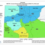
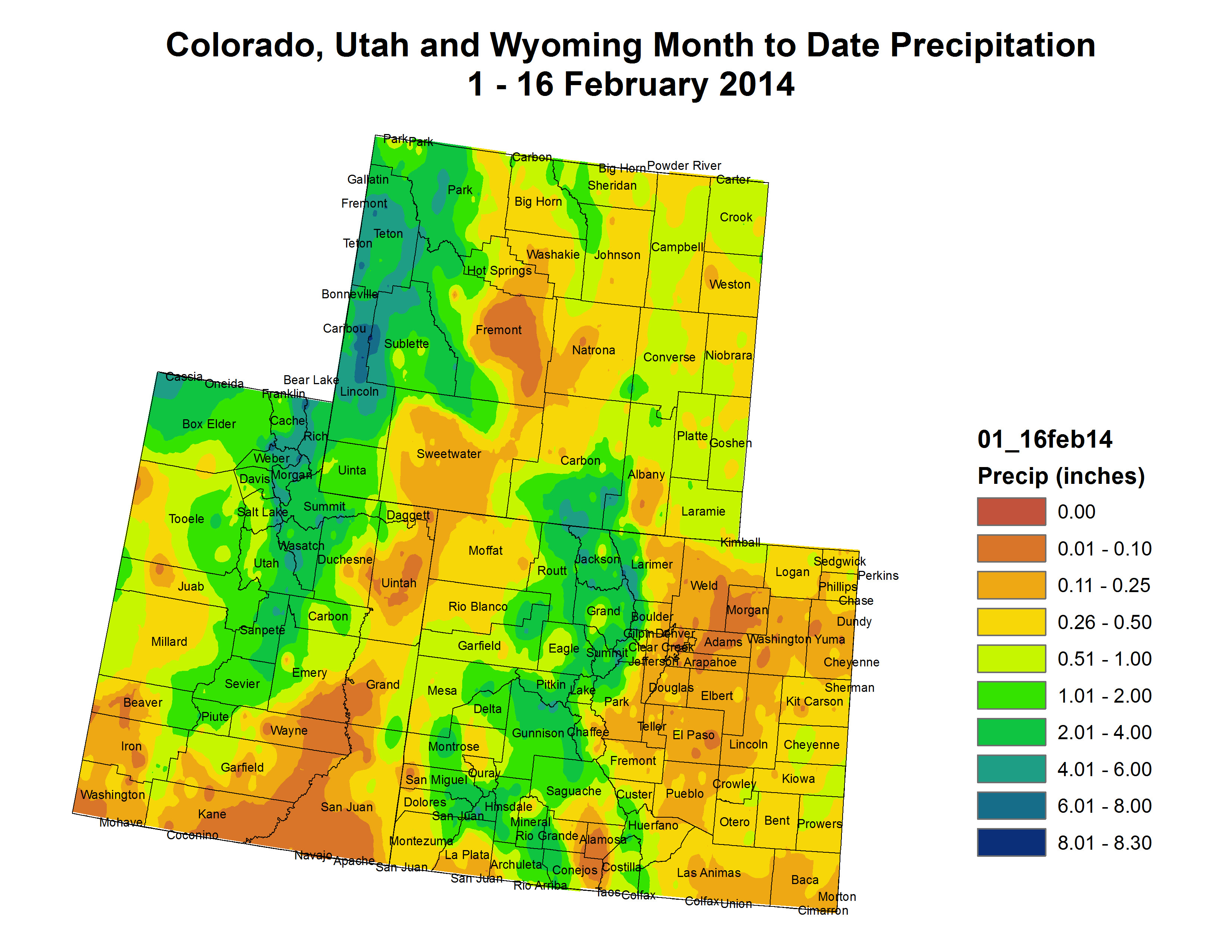
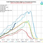
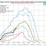
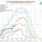
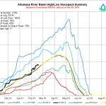
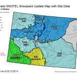
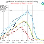
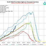
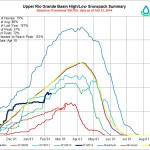
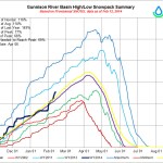
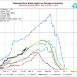
The Water Year to Date (WYTD; since October 1) continued to be dismal as little to no precipitation and unseasonable warmth (temperatures averaging 8 to 12oF above normal, highs in the 70’s and 80’s) were observed this week. With the exception of copious and flooding rains back in early to mid-September, especially in New Mexico and Colorado, most southwestern locations have measured well below normal precipitation since then. The few exceptions to this were small WYTD surpluses in southwestern and northeastern Arizona, northern New Mexico, and most of western and central Colorado, the latter state faring the best this season. Elsewhere, WYTD SNOTEL basin average precipitation ranged from 50-63% of normal in central Arizona, 30-46% in southern New Mexico, 52-73% in northern New Mexico, 51-90% in southern Utah, and 81-102% in southern Colorado. Values generally rose to above normal in more northward basins. The Feb. 18 basin average snow water content ranged from 0-83% in central Arizona, 10-19% in southern New Mexico, 8-60% in northern New Mexico, and close to normal in southern sections of Utah and Colorado. With such poor values, a 1-category degradation was made in southwestern Arizona (D0 expanded); southern Nevada (D1 expanded, only 0.05” of precipitation at Las Vegas McCarron Airport since Dec. 1 and non-irrigated, drought-tolerant landscaping plants starting to dry out); D2 expansion across central and southern Arizona and into western New Mexico; D3 development in southeastern Arizona (where 6-month totals less than 50%); and slight D2 and D3 increases in central New Mexico – after their driest January on record. As of Feb. 1, average state reservoir capacities were 23% (normal=44%) for New Mexico and 13% (normal=47%) for Nevada. Colorado and Utah were close to normal, and Arizona data was unavailable (on Jan. 1, 44% vs normal=51%)…

The West

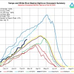
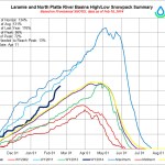
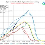
Unfortunately, last week’s overdue and welcome moisture was short-lived for most of California as the weather pattern shifted and brought moderate to heavy precipitation (4 to 8 inches, locally 12-18 inches) northward to the Pacific Northwest. Extreme northern California did benefit from this week’s moisture, including Del Norte County in extreme northwestern California, where 10-15 inches of precipitation fell as the Smith River rose 20 feet and passed monitoring stage, and has since receded to a flow 6 feet higher than before the rain started. In addition, along coastal Oregon and Washington and in the Cascades, widespread heavy precipitation was enough to make a general 1-category improvement in the drought, especially since the dryness was more short-term than compared to California’s multi-year drought. Unfortunately, the moisture was accompanied by mild air, and most of the precipitation that fell on the southern Cascades was rain and not snow. As a result, southern Oregon’s basin average snow water content remained low, between 30-39% of normal on Feb. 18, and no changes were made here. Farther north, however, temperatures were lower, and much of the precipitation fell as snow in the higher elevations. In northern Oregon, the average basin snow water contents for the central Cascades increased to 51-63% of normal, while the northern Cascades in Washington rose to between 71-87% of normal. Short and medium-term deficits, however, still remain, and additional moisture will be needed to bring the WYTD precipitation to normal. Weekly totals (about an inch) were lower in northeastern Washington, and the D2 area remained. Additional moderate to heavy snows fell on the northern and central Rockies, boosting WYTD average basin precipitation and Feb. 18 snow water contents to near or above normal, justifying a 1-category improvement where the heaviest precipitation fell and deficits were greatly reduced.

In contrast, southern California missed out on both week’s precipitation while unseasonable warmth persisted, further degrading conditions similar to the Southwest. With WYTD precipitation running at a meager 10-30% of normal across coastal southern California and deficits of 4-12 inches the past 6-months, D3 was extended southward into the San Diego area, and D4 was expanded southward into Santa Barbara and Ventura Counties. In Santa Barbara County, Lake Cachuma, currently at 39% capacity and 90% of the water supply for the cities of Santa Barbara and Goleta, the water level is nearing the lowest intake on the outlet works. To remedy this, the water district is working on installing a floating barge and pipes to get lake water to the outlet portal. The city is also contemplating the re-establishment of a desalination plant built in the late 1980s that was shut down in the early 1990s. And the Twitchell Reservoir, along the Santa Barbara/San Luis Obispo County line, is at less than 1% capacity. Ranchers are reducing their herds due to the lack of water and food sources. As of Feb. 18, the Sierra Nevada basin average snow water content ranged from 32 to 53% of normal. Widespread heavy precipitation is badly needed in this state as the normal wet season nears its end by early to mid-spring (e.g. in April)…

Looking Ahead

During February 20-24, a drier weather pattern is expected for the Northwest, while significant precipitation is expected across the eastern half of the Nation, particularly in the Midwest, Southeast, and New England. Unfortunately, dry weather should persist across the southwestern quarter of the U.S., including California, Nevada, Arizona, and New Mexico, and most of Texas. Temperatures will also average above normal for much of the lower 48 States, except for another blast of Arctic air entering the northern Rockies and Plains and upper Midwest later in the period.

For the ensuing 5-day period, February 25-March 1, the odds favor subnormal readings east of the Rockies and above-normal temperatures in the Southwest. Chances are favorable for above-median precipitation in the West, especially along the California-Oregon border and northern Sierra Nevada. To the east, precipitation is likely along the Gulf Coast States. In contrast, the odds for below median precipitation are forecast for the southern Rockies northeastward into the northern Plains, upper Midwest, and Great Lakes region, with slight chances of below-median precipitation in the Northeast.

SB14-103 passes out of the state Senate

Low flow toilet cutout via The Ultimate Handyman

From the Associated Press via KJCT8.com:

A mandatory phase-out of toilets, faucets and shower heads that use too much water has cleared the Colorado Senate. Senators voted 19-16 in favor of a bill to prohibit the sale of low-efficiency plumbing fixtures by 2016. The measure would make it illegal to sell new faucets, showerheads and toilets that aren’t certified by the federal government as efficient “WaterSense” fixtures.

Only one Republican voted for the change, Sen. Ellen Roberts of Durango. She called the bill a needed effort to conserve water in a drought-plagued state.

The measure would not require anyone to change existing plumbing. Current law requires builders to offer water-efficient indoor plumbing fixtures in new homes, but homeowners aren’t required to choose them.

The bill now heads to the House.

More 2014 Colorado legislation coverage here.

Dolores River: Instream flow right below confluence with the San Miguel River?

Dolores River Canyon near Paradox

From the Cortez Journal (Jim Mimiaga) via The Durango Herald:

A spirited debate before the Colorado Water Conservation Board in Denver in January featured local officials expressing their opinions about a plan to increase flows on the lower Dolores River.

A live Internet broadcast of the hearing presented views for and against appropriating new minimum in-stream flows on a 34-mile section of the river below the confluence of the San Miguel River.

Representatives from the Dolores Water Conservancy District, in Cortez, and the Southwestern Water Conservation District, in Durango, attended the meeting and urged the state board to delay the matter. Local officials say new in-stream flows could threaten agricultural users who depend on McPhee Reservoir, and they want more time for negotiations with local federal agencies about newly implemented river regulations.

But they were rebuffed by the state board and state officials who argued the in-stream flows were a good way to protect struggling native fish and avoid intervention by the federal government moving to list them under the Endangered Species Act…

The proposed in-stream flow on the Dolores is for 900 cfs to flow for 61 days in the summer to aid the flannelmouth sucker, bluehead sucker and roundtail chub below the San Miguel confluence.

Eleven organizations commented on the proposed in-stream flow, some for and some against.

Mike Preston, general manager for the Dolores district, urged the state board to delay its intent to appropriate the new Dolores in-stream flow.

“These ISFs are intertwined with recent federal actions that add up to create considerable uncertainty and risk for the Dolores Project,” he said. “We ask for the delay to straighten out these issues with federal land agencies.”

The in-stream flow proposal comes on top of recent federal action on the Dolores that elevates two additional native fish, the bluehead and flannelmouth suckers, to a category called Outstanding Remarkable Values.

The values are used to categorize special aspects of rivers like the Dolores that are designated “suitable” for National Wild and Scenic River status.

Creating that official high level of protection would require an act of Congress. But reservoir managers oppose even a hint of Wild and Scenic because if ever designated, those rivers come with a federally reserved water right that could force water from McPhee to be released downstream for the benefit of native fish.

State water board director John McClow said that the in-stream flow was a good solution and questioned why it had so much resistance.

“I’m having a difficult time connecting the dots here,” he said. “We have argued to federal agencies that in-stream flows are a better option than suitability. If we declare intent to appropriate, it lets the federal agencies know that we are serious and are going to do this and provide the protection for these fish.”

After the testimony, the state water board voted unanimously to declare its intent for appropriating the proposed in-stream flows on the Lower Dolores River.

However, to give time for stakeholders to negotiate with the Bureau of Land Management about the possibility of dropping Wild and Scenic suitability, the hearing about the matter was delayed until January 2015.

Here’s a guest column about the proposed instream right and the Dolores Project, written by Mike Preston that’s running in the Cortez Journal:

There is a lot going on these days that could affect the Dolores Project and many recent events have received newspaper coverage. This column is intended to put these events into a broader context that will help those who are interested understand what is going on as this story continues to unfold.

Let’s start with the biggest long term risk to Dolores Project water supplies: A listing of any of the three sensitive native fish species on the Dolores River as Threatened and Endangered. This would put the US Fish and Wildlife Service in charge of the Dolores River resulting in a loss of control by everyone else. What is being done? Local partners including water managers, fishery managers, conservation groups, boaters and county commissioners are working together to put together a science based Native Fish Implementation Plan to evaluate opportunities to address the needs of native fish without putting water supplies as risk.

The next level of risk is the Wild and Scenic Rivers Act as a result of additions to the recently released BLM and Forest Service resource management plans which list the two sensitive native fish as Outstandingly Remarkable Values which Implementation Plan monitoring show to be uncommon and rare above the confluence with the San Miguel River. The federal plans also added flow standards that are unachievable below McPhee Reservoir. What is being done? DWCD and Southwestern Water Conservation District (SWWCD) are actively protesting and appealing these plans with the support of the State of Colorado, Colorado Water Congress, local counties and west slope water entities.

There is also a large instream flow proposed on the Dolores River below the San Miguel confluence. Representatives of DWCD and SWWCD recently appeared before the Colorado Water Conservation Board (CWCB) and asked that the instream flow proceeding be delayed until risks associated with the federal plans are addressed. The CWCB granted a delay until January of 2015 and pledged State of Colorado support in resolving the federal issues described above. The one year delay also gives local water boards the opportunity to negotiate protections to insure that the instream flow will pose no risks to water stored in McPhee and other water rights within the basin.

Given the need to manage these multiple risks, what can be done to create stability and certainty going into the future? There is a Legislative Subcommittee made up of County Commissioners, Water Managers, and Conservation Groups, grazers and OHV users that is crafting legislation that will eliminate the Wild and Scenic River designation from McPhee Dam to Bedrock, protect water rights and Dolores Project allocations, recognize the Native Fish Implementation Plan as the means of taking care of the fish, while protecting water rights, mineral rights, private property rights and access.

Are we going to be able to succeed in all of these activities designed to protect community water supplies? These efforts are grounded in community level cooperation by representatives of the full range of Dolores Project purposes: irrigation, community water providers, boating, the fishery and the health of the downstream environment. If we all stick together, we will find a way to do what’s right by our community. As this story unfolds we will make every effort to keep you informed.

More Dolores River watershed coverage here and here.

‘Colorado Supreme Court rules against holders of vested water rights inside and outside of an Indian reservation’ — Lexology

Non-Tributary coalbed methane SW Colorado via the Division of Water Resources

From Lexology (Daniel C. Wennogle):

In 2010 a group of water rights holders in Colorado raised a constitutional challenge to certain rules promulgated by the Colorado State Engineer’s Office regarding the designation of certain ground water resources as “nontributary.” The particular groundwater resources were located, in part on an Indian reservation, and the State Engineer’s determination was a part of an effort to promulgate rules regarding the permitting and regulation of oil and gas wells that extract groundwater in Colorado.**

The rule in dispute, referred to as the “Fruitland Rule,” was part of a set of “Final Rules” promulgated by the State Engineer under its authority granted by HB 09-1303, codified at C.R.S. § § 37-90137, 37-90-138(2), and 37-92- 308(11) (C.R.S. 2009). The Fruitland Rule related to underground water in a geologic formation called the Fruitland Formation, which extends into the Southern Ute Indian Reservation. The Final Rules, which included the Fruitland Rule, contained a provision stating:

These rules and regulations shall not be construed to establish the jurisdiction of either the State of Colorado or the Southern Ute Indian Tribe over nontributary ground water within the boundaries of the Southern Ute Indian Reservation as recognized in Pub. L. No 98-290, § 3, 98 Stat. 201 (1984).

The Plaintiffs argued that the above-quoted provision in the Final Rules effectively divested the State Engineer from having jurisdiction to, among other things, designate water as nontributary in its rulemaking process. The trial court had agreed with this position, and stated that the State Engineer did not prove its authority. The Court of Appeals, however, reversed and held that the State Engineer’s authority came from HB 09-1303, which “authorized the State Engineer to promulgate the Final Rules to delineate nontributory groundwater extracted in oil and gas production throughout the state” of Colorado.

The Court of Appeals held that nothing about the above- quoted statement in the Final Rules did or could divest the State Engineer of this authority.

The Court of Appeals noted that its decision would not prevent a constitutional challenge to the Fruitland Rule based upon discriminatory application, if facts warranted.

More coalbed methane coverage here and here.

El Paso Couny: ‘The stormwater task force is leaning toward a new regional authority’ — Mark Pifher

Channel erosion Colorado Springs July 2012 via The Pueblo Chieftain

From The Pueblo Chieftain (Chris Woodka):

El Paso County is moving toward a regional stormwater authority that could be formed in an election this November. The Lower Arkansas Valley Water Conservancy District heard that news Wednesday from Mark Pifher, Colorado Springs Utilities permit manager for the Southern Delivery System.

“The stormwater task force is leaning toward a new regional authority that would be funded by a fee rather than a sales tax or property tax,” Pifher said.

The fee would be based on square footage of impervious surfaces, such as other cities throughout the state, including Pueblo. While no public vote is required for a fee, El Paso County officials recognize that a vote would be prudent to form the authority that would assess the fee, Pifher said.

The latest estimate of stormwater needs in El Paso County is at $724 million, with $192 million in critical needs. Of that, $534 million is needed for Colorado Springs, with $161 million in critical projects. An additional $40 million is estimated so far to deal with impacts from the Waldo Canyon and Black Forest fires.

The Lower Ark board still is looking at a possible federal lawsuit against the Bureau of Reclamation for its refusal to reopen an environmental impact study for SDS that calculates impacts without a stormwater system in place. The district is concerned that increased flows from SDS development will worsen conditions on Fountain Creek. Reclamation issued a record of decision for SDS in early 2009, which became the basis for contracts issued the following year. Later in 2009, the Colorado Springs City Council abolished the stormwater enterprise it had formed in 2005 based on its interpretation of a ballot question sponsored by Doug Bruce, who referred to the fee then in place as a “rain tax.”

The stormwater task force formed in 2012 in response to a city attorney’s opinion that the city was obligated to deal with stormwater in order to operate SDS.

More stormwater coverage here and here.

The Ridgway Town Council approves bumping storage in Lake Otonowanda to 600 acre-feet

Lake Otonowanda -- photo / Applegate Group
Lake Otonowanda — photo / Applegate Group

From The Watch (Samantha Wright):

Located in Ouray County, about three miles south of Ridgway off of County Road 5, Lake O has been the Town of Ridgway’s primary municipal water source for nearly 100 years. The man-made lake is filled with water diverted into a natural basin via the Ridgway Ditch.

The Lake Otonowanda Rehabilitation Project will allow the town to exercise its full decreed storage right there by improving the lake’s capacity sixfold, from 100 to 600 acre feet, while restoring historic tunnel outlet works, which collapsed decades ago, to allow water to flow from the lake to town without having to be pumped.

The project is split into two phases, addressing tunnel restoration and lake excavation. Town officials had hoped to get started on the tunnel restoration phase last fall, but received only one response to a Request for Proposals issued in September 2013.

Hoping to attract more bidders, council and town staff agreed to broaden the scope of the contract to encompass both the tunnel restoration phase and lake excavation phase in a single package, and put the project out to bid in January.

This time around, there was a healthy response from contractors, with Town Manager Jen Coates reporting that over 30 people attended the project’s pre-bid meeting on Jan. 30; five of those companies went on to actually bid on the contract, with bids ranging from $1.4 to $1.9 million. The town budgeted up to $2 million for the construction project (bonding requirements put many smaller-scale local contractors out of the running, Coates said).

The Colorado Water Conservation Board awarded a $1.2 million grant/loan package to the Town of Ridgway last fall to help finance the Lake O project. In late January, the town applied to the Colorado River District for additional grant funds to cover a portion of the project construction.

More Uncompahgre River Watershed coverage here and here.

Aspinall Unit update: 400 cfs through the Black Canyon

Black Canyon via the National Park Service

From email from Reclamation (Erik Knight):

Due to the increasing forecasts for spring runoff into Blue Mesa Reservoir, flows in the Gunnison River through the Black Canyon are now set at 400 cfs.

More Aspinall Unit coverage here.

CWCB: February #COdrought update

US Drought Monitor February 11, 2014

Click here to read the drought Update from the Colorado Water Conservation Board (Ben Wade):

Late January and early February precipitation across the state improved the statewide snowpack from 107% on February 1 to 117% as of February 12. The snowpack in every basin in the northern portion of the state is well above average with the highest being the South Platte basin at 141% of average. The southern portion of the state continues to see below average precipitation overall for the current water year. Moderate to exceptional drought conditions remain on the eastern plains, with D0 reintroduced in the southwest portion of the state where no classification was indicated in the January report. Storage levels in all basins are better than they were this time last year; however the northern half of the state is doing better than the southern basins.

 January statewide temperatures were near normal with the foothills slightly above normal for the month. Temperatures statewide from February 1-11 are near normal to 10 degrees below however, the Eastern Slope has experienced temperatures varying from 10 to 25 degrees below normal.

 Currently, 74% of the state is in some level of classification according to the US drought monitor slightly up from January. 52% of that is characterized as “abnormally dry” or D0, while an additional 9% is experiencing D1 or moderate drought conditions. 9% is classified as severe, 2.5% as extreme and only 1.47% of the state remains in exceptional drought. In comparison, this time last year 100% of the state was classified as experiencing severe to exceptional drought conditions.

 Snowpack has risen statewide due to storms in late January and early February. As of February 12, the highest snowpack was in the South Platte Basin at 141% of average. The Rio Grande, has the lowest snowpack at 79% of average, a decrease from 82% as of February 1. NRCS is ground-truthing snotel stations in the Rio Grande basin as there are indications they may be providing erroneously low readings due to snow pillow bridging and rain gage capping.

 For the current water year, starting on Oct 1, 2013, precipitation statewide is at 108% of average as of February 12. The Rio Grande and San Juan/Dolores basins are the lowest at 85% and 90% respectively, although so far in the current month both basins are receiving above average precipitation.

 The streamflow forecasts statewide range from 67-125% percent of average. The highest streamflow averages are in the Yampa/White and Colorado basins. Streamflow forecasts have decreased in the southwest part of the state since January 1.

 Reservoir Storage is at 90% of average which is an increase from 87% at the end of December 2013. At this same time last year, reservoir storage was at 69% of average. The lowest reservoir storage is in the Arkansas & Rio Grande basins, with 64% and 65% of average respectively.

 Parts of Crowley County have experienced problems with an abundance of tumbleweeds due to the extensive drought in the southeastern part of the state. The tumbleweeds have clogged ditches and roads and some citizens have been rescued from their homes due to massive pile ups of tumbleweeds. Financial assistance is being sought after to deal with the ongoing issue.

 The water providers in attendance reported their respective systems and storage levels are in good shape and they continue to closely monitor conditions to determine if additional actions need to be taken.

More CWCB coverage here.

Draft #COWaterPlan emphasizes the importance of ag

Flood irrigation -- photo via the CSU Water Center
Flood irrigation — photo via the CSU Water Center

From The Greeley Tribune (Eric Brown):

More irrigated farmland will no doubt go out of production, but the economic impact of agriculture in Colorado must maintain its current levels in the future. That was put in writing by the Interbasin Compact Committee on Tuesday, as the group continued piecing together the language that could make up the official Colorado Water Plan.

T. Wright Dickinson of Maybell was among the most adamant about protecting ag.

“There’s the assumption … that to meet the water needs of everyone else, ag will crumble,” said Dickinson, an IBCC member and former president of the Colorado Cattlemen’s Association. “I won’t be any part of it. There has to be language (in the Water Plan) that says Colorado will do everything it can.”

The long-term Colorado Water Plan is expected to consist largely of input from the 27-member IBCC — made up of water experts, lawmakers, engineers, farmers and others from throughout the state.

The group on Tuesday agreed on language that stressed ag’s economic importance, along with other language saying that new water projects in the future must consider any negative impacts on the state’s ag industry.

Tuesday’s discussions focused solely on new-supply issues.

Months ago, members of the IBCC agreed on “low risk” and “no risk” water solutions regarding conservation, water reuse and other issues. They didn’t agree on their “low risk” and “no risk” solutions for new supply until Tuesday.

Now with “conceptual agreements” on the new-supply language in the Colorado Water Plan draft, IBCC members will take that draft to their respective basin roundtables for further discussion. Gov. John Hickenlooper wants a draft report of the Colorado Water Plan by the end of next year, but there’s still a long way to go, with the “high risk” solutions still needing to be discussed and agreed upon down the road.

Compromising on some aspects is difficult, because each of the basin’s issues vary from one another and require different solutions. Even the discussions on “low risk” and “no risk” solutions have been contentious at times.

Agriculture has been at the heart of the discussions.

As Colorado cities have grown quickly in recent decades, those expanding municipalities have bought water supplies from farming and ranching families leaving the land, because comparatively it’s an inexpensive way to acquire needed supplies. But, according to the 2010 Statewide Water Supply Initiative study, the state was on pace to see about 500,000 to 700,000 acres of irrigated farmland dry up by 2050, an outcome that would hurt the local food supply, diminish ag’s estimated $40 billion impact on the state’s economy, and place hardships on Colorado’s rural communities.

Because water supplies are already tight in Colorado, and because agriculture uses the bulk of the state’s water supplies — about 85 percent, according to the Colorado Division of Water Resources — water experts say it’s inevitable that cities down the road will buy out more water from agriculture to meet their needs.

Members of the IBCC said Tuesday that with improved efficiencies in ag production — technology and methods that have farmers now growing 200-bushel-per-acre corn, as opposed to 20-bushel-per-acre corn decades ago — farmers should be able to produce more food on less acres down the road. Perhaps farmers could also grow more high-value crops on fewer acres, some suggested.

But advancements in the industry and different farming practices alone won’t cut it.

Whatever the specifics may be, IBCC members said that farmers and ranchers must work more closely with cities and recreational and environmental interests — creating water banks, or using alternative transfer methods, rather than selling off their water — to slow down the current rate of “buy and dry” of irrigated ground in the state.

Members of the IBCC said Tuesday they felt strongly enough about the issue that they wanted it down in writing in the Colorado Water Plan.

“We have to do anything we can not to exacerbate ‘buy and dry,’” said Eric Wilkinson, the general manager of Northern Colorado Water Conservancy District, which oversees the largest water-supply project in the region — the Colorado-Big Thompson Project. “We can’t keep doing what we’re doing.”

From the Sky-Hi Daily News (Leia Larsen):

At a Grand County town hall meeting in Granby on Feb. 12, most of those stakeholders included ranchers, water engineers and representatives from the county’s municipalities. They came to learn more about the Colorado state water plan, find out what is means for the Colorado River basin and express their concerns…

Louis Meyer, a civil engineer with the company SGM, was contracted to help prepare the Colorado water plan. He said that while the governor’s timeline is aggressive, preparing a water plan is both timely and necessary. Most states in the Western U.S. have water plans. Only Washington, Oregon, Arizona and Colorado lack one…

According to Meyer’s town-hall presentation, municipal and industrial consumption account for 9 percent of the state’s water use. Recreation, fisheries, augmentation and recharge take 5 percent. The majority of the state’s water use, 86 percent, goes to agriculture. To close the future water gap, at least some of the state’s conservation efforts might have to come from agriculture.

But local ranchers took issue with that figure. While most of the state’s agriculture is concentrated on the Front Range, east and southwest regions of the state, it’s still a significant part of Grand County’s economy. As meeting attendees pointed out, many ranchers in the Kremmling area use flood irrigation in the spring for their hay, making their fields look like lakes by the summer.

“You’d assume the water was used and gone forever if you didn’t know any better,” said Chris Sammons, whose family has ranched in the area for over 100 years. “But the ground is a sponge, soaking up water, recharging it back into the basin and downstream.”

Sammons figures her hay only consumes a tiny portion of the actual irrigation water she uses. Sending the rest of that irrigation water back downstream helps Colorado meet its water rights obligations to other Western states and the nation of Mexico. That’s not the case with water piped to the East Slope.

Other suggestions coming from Grand County locals included stronger leadership among government officials managing water and lands, with lower turnover in these roles. They also suggested changes to the state’s land uses and development, and stronger educational campaigns on the true cost of water in the state.

More Colorado Water Plan coverage here.

What Does the Return of El Niño Mean for Colorado? — Matt Makens #COdrought #COwx

Jet Stream patterns El Nińo /La Nińa via NWS Boulder
Jet Stream patterns El Nińo/La Nińa via NWS Boulder

Here’s a primer of sorts about El Nińo and the possible effect on Colorado weather from Matt Makens writing for Weather5280.com. Click through and read the whole post and check out the great graphics. Here’s an excerpt:

The fact is, where we live, an El Niño or La Niña pattern doesn’t change our temperatures or moisture outlook. It may shift where heavier precipitation will fall, but it doesn’t do much for the state as a whole. There are seasonal changes for some regions that can be of benefit/detriment, but the scale of a year and only looking at the state yields little excitement.

In general terms, the ENSO (El Niño Southern Oscillation) is yet another ocean-atmosphere connection that affects the storm track and speed over Colorado. During La Niña (as in this winter) heavier snows hit the northwestern mountains and more frequent cold snaps occur for the plains with periods of strong wind. However, in El Niño the heavier snowfall shifts to the southwestern mountains and the temperatures remain a bit warmer…

Notice how there isn’t a correlation between ENSO and Colorado’s temperatures and precipitation? I did a quick analysis for Denver and there are not any correlation there either. Just because the headlines tout a change on the way and you may want to throw an El Niño welcome party, there’s little to get worked up about here in Colorado from the state’s perspective. Okay, yes if you are in the southwestern mountains and wanting a good winter snowfall you want El Niño, but don’t get your hopes up too soon, the El Niño indicator is a weak one and may not hold on for next winter…

We are in a long lasting drought (most severe over the southeast), and what the entire state needs right now is moisture. Aside from the singular flooding event for northern Colorado back in September, we too would still be in a drought. The state’s agricultural community needs a multi-decadal pattern switch that simply the ENSO pattern itself can’t fix. However, a quick transition from La Niña to El Niño this spring and early summer would be nice…in that change, climatologically the southeastern plains have the best chance for above normal precipitation. However, a bigger pattern change with El Niñ0 and other factors coming together is what it will take to make major state climate changes.

There are so many more important influencing factors from other patterns, like MJO, AMO, and PDO that do have a direct correlation to our hotter/drier versus cooler/wetter patterns.

The latest newsletter from the Greeley Water is hot off the presses

Snowpack news (% of average): South Platte = 147%, best in state #COdrought

Mage at the NRCS has been busy. Click on a thumbnail to view the gallery of graphics.

From The Pueblo Chieftain (Chris Woodka):

A better water supply outlook should make more water available for Arkansas Valley farmers this year, but the details still are being worked out. The Pueblo Board of Water Works, which generally leases the most water on the spot market, heard a favorable snowpack report Tuesday, but still is weighing its options.

“We will be looking at those options in the next 30 days,” said Terry Book, executive director of the Pueblo water board.

Specifically, the water board wants to find out how many of those who have asked for long-term contracts (more than one year) are serious. That will determine how much of this year’s pool of water could be leased, said Alan Ward, water resources manager.

Pueblo’s water supply should be ample this year because snowpack is expected to easily reach average peak levels this year. Right now, snowpack in the Arkansas River basin is 110 percent of median, and 182 percent of last year. In the Colorado River basin, from which much of Pueblo’s water is imported, levels are at 131 percent of median. Even better news, for Pueblo at least, is that in the headwaters of the Arkansas River and in the Upper Colorado snow levels are at 150 percent of average.

“It’s looking good for us, as well as for the Fryingpan-Arkansas Project,” Ward said.

Snowpack in the southern mountains which feed the Purgatoire River and Rio Grande are much lower, as recent storms have tracked mainly through the northern part of the state.

The water board typically leased 10,000-20,000 acre-feet of water on the spot market, but held off in 2013 because of continuing drought conditions. The long-term contracts are typically more than three times the rate for the spot market and provide more certainty of revenue for the water board. The downside is that when water is not available, long-term contracts might have to be suspended. The water board had nearly 37,000 acre-feet of water in storage at the end of January, up by about 10,000 acre-feet from last year at the same time.

From the Summit Business Journal (Robin Smith):

Shades of 2008 and 1980’s Big Wednesday – for once, weather forecasts corresponded with the snow amount smothering Aspen/Snowmass residents’ walkways and balconies, as over 30 inches accumulated in the last two days [January 29-30].

The initial 15-30 inch prediction was originally viewed as a jinx against any significant snowfall, particularly when Thursday morning dawned with only 2-6 inches on the slopes. However, the storm hunkered down and by twilight, 15 inches were verified. Out came the shovels and snow blowers – and out they came again today, as another 18 inches greeted the sunrise.

SB14-103: ‘I don’t believe it [government] belongs in the bathroom’ — Sen. Larry Crowder #COleg

Low flow toilet cutout via The Ultimate Handyman

From the Associated Press (Kristen Wyatt) via TimesUnion.com:

Water-chugging faucets, toilets and showerheads could become illegal in Colorado under a bill that won preliminary approval in the state Senate Tuesday.

A bill to prohibit the sale of low-efficiency plumbing fixtures by 2016 won approval on an initial unrecorded voice vote.

The measure would make it illegal to sell new faucets, shower heads and toilets that aren’t certified by the federal government as efficient “WaterSense” fixtures.

“Every little bit that we can do to conserve water is important,” said Sen. Lucia Guzman, D-Denver and sponsor of the bill. Guzman and other Democrats pointed out that most fixtures sold today are already compliant.

The measure would not require anyone to change existing plumbing. Current law requires builders to offer water-efficient indoor plumbing fixtures in new homes, but homeowners aren’t required to choose them.

Republicans tried unsuccessfully to stop the measure by arguing that water-efficient plumbing fixtures should sell themselves.

“I don’t believe the government needs to come in and say, ‘This is what you have to do,’ ” said Sen. George Rivera, R-Pueblo.

The debate got a little punchy, with senators debating the relative merits of low-flush toilets and weak shower heads. One Republican even showed a clip from a 1996 episode of the sitcom “Seinfeld,” in which characters look for black-market fixtures after their apartment converts to low-water models.

Lawmakers couldn’t avoid a little potty humor as they debated the measure.

“I don’t believe government belongs in the bedroom, and I don’t believe it belongs in the bathroom,” said bill opponent Sen. Larry Crowder, R-Alamosa.

One more Senate vote is required before the plumbing measure heads to the House.

More 2014 Colorado legislation coverage here.

US House votes to reauthorize national drought information system #COdrought

Snowpack news

From the Salida Citizen (Christopher Kolomitz):

We all know that during the past two weeks a pineapple express of moisture has been slamming into the Rockies and it has done magical things to the snowpack, especially compared to the past two years. But as our memories fade, one winter blends into the next and it’s hard to recall specifics. Luckily, a series of weather stations in the Colorado mountains record climate data.

By looking at that data which goes back to 1979, we can determine what level of “epicness” the past two weeks puts us on. And, it appears we are on track with the legendary winters of the early 1980s, the snowy mid-90s and a much needed wet year of 2008. We seem to be a little ahead of the big year of 2011…

Here in the Arkansas Basin we sit at 115 percent of average snowpack. Nine different SNOWTEL stations are in the basin and seven are used to figure that percentage. Of the nine, Brumley, Fremont Pass, St. Elmo and Porphyry Creek are especially important for us in the Upper Arkansas Valley because the other six (Apishapa, Glen Cove, Hayden Pass, South Colony and Whiskey Creek) are located in drainages below and southeast of Salida. Because the St. Elmo and Hayden Pass sites were installed in 2007, they are not used when developing historical averages.

On Feb. 12, I looked at the SWE for Fremont Pass and Porphyry Creek, which is at Monarch Pass, just west of the summit in Gunnison County. Yes, it’s technically on the Western Slope but it is being used to calculate Arkansas Basin figures because of its strategic location. And, because most of us want to compare the skiing, I dialed a little more into the numbers at this site.

Monarch has been blasted since the early part of the month and the ski area is reporting 11 feet in the past two weeks. As of Feb. 12 the SWE at Brumley was at 15 inches, so I compared that with the historical SNOTEL data.

In the last 14 years only once (2008) has it been that depth at this point in the season. During the past 35 years 15 inches of SWE this early has been reached only four times – 1984, 1996, 1997 and 2008.

In 10 winters (1980, 82, 84, 86, 93, 96, 97, 2005 and 08) the 15 inch SWE mark was achieved by the end of February. On the flip side, another 10 winters (1981, 89, 90, 91, 99, 2000, 04, 07, 12 and 13) failed to reach the 15 inches of SWE at all.

In 2011 when it seemed as if it would never stop snowing in the spring, Porphyry reached 15 inches of SWE on March 1. It hit 18.2 inches in April that year and then maxed out at 19.7 in May.

Since 1979 the highest SWE for Porphyry was in May of 1984 when it reached 27.4 inches. The 15 inches of SWE was eclipsed in early January that year.

In the winter of 1995 the site reached SWE levels equal with this year on March 10. That year the maximum SWE was 24 inches. A year after, in 1996, 15 inches of SWE was hit Feb. 2.

Further north on Fremont Pass, at the headwaters of the Arkansas, the SNOWTEL site Feb. 12 was measuring 13.3 inches of SWE and a depth of snow of 64 inches. The winters of 1996, 2006 and 2011 all had SWE greater and sooner. In 1996, the SWE reached today’s levels on Jan. 25 and by May it was above 27 inches.

Looking at the most recent winters of 2011-2013, it’s clear that at Fremont Pass, things are in much better shape than the past few years. Last year the SWE didn’t reach current levels until April 5, although it maxed out later in May at 19.1 inches and helped save runoff.

Drought in 2012 was evident when the SWE made it only to 12.4 inches for the entire year. But, the snowy year of 2011 was better than all when the SWE passed today’s levels on Jan. 31 and reached 26.7 inches May 5.

The South Platte Roundtable is holding a series of input and information sessions for the #COWaterPlan

Colorado Water Plan website screen shot November 1, 2013

From The Greeley Tribune:

The South Platte Roundtable will be hosting a serious of input and information sessions around the region during the upcoming weeks, as it continues piecing together its comprehensive, long-term water plan for northeast Colorado.

Each of the basins in Colorado are putting together individual water plans, which will help make up the collective Colorado Water Plan — an effort put in motion by Gov. John Hickenlooper.

All meetings will be from 3:30-7 p.m., and will include an overview of the South Platte River Basin’s water supplies and needs, and will also feature Q and A sessions and information displays.

The meetings will take place on:

• Feb. 26, Clarion Inn in Fort Morgan, 14378 U.S. 34.

• March 3, Metro State College in Denver, 900 Auraria Parkway, Suite No. 250.

• March 5, Southwest Weld County Complex in Longmont, 4209 Weld County Road 24 1⁄2.

• March 19, the Fair Barn in Fairplay, 880 Bogue St.

• April 10 in Yuma (held in conjunction with the Republican River Water Conservancy District’s regular quarterly meeting).

For more information, contact SouthPlatteBIP@hdrinc.com or cowaterplan@state.co.us.

More Colorado Water Plan coverage here.

SB14-115: Update from Sen. Gail Schwartz #COleg #COWaterPlan

More 2014 Colorado legislation coverage here. More Colorado Water Plan coverage here.

Say hello to CFWE’s Water Educator Network

bouderchildrenswaterfestivalmay2012dailycamera
Click here to go to the website. From email from the Colorado Foundation for Water Education (Kristin Maharg):

I’m reaching out to the Colorado Water 2012 community to let you know how the Colorado Foundation for Water Education has since built upon the successes of that coalition. With support from Xcel Energy and partnering with the Colorado Alliance for Environmental Education, we are developing the Water Educator Network to offer tools, trainings and collaborations that are relevant to your work, easily accessible and simple to implement.

As a teaser of this all new program, we’d like to invite you to attend a FREE lunchtime webinar on February 25. For those of you involved in your local watershed festival, you won’t want to miss this opportunity to gear up for spring festival season, learn from long-time organizers and discuss ways to improve the overall experience. Register today for the Water Festival Planning and Coordination webinar.

Visit the Water Educator Network web page to see how CFWE is gearing up to deliver technical assistance and resources to our community. After an “orientation” webinar on March 19, CFWE staff will reach out to you again to become a member of this exclusive network for only $100/year. In the meantime, please feel free to contact me with any questions or suggestions.

More Colorado Foundation for Water Education coverage here.

Glenwood Springs proposed RICD application is drawing the attention of other #ColoradoRiver users

City of Glenwood Springs proposed whitewater parks via Aspen Journalism

From the Aspen Journalism (Brent Gardner-Smith):

The West Divide Water Conservancy District of Rifle filed a “statement of opposition” with District Court, Water Division No. 5 on Jan. 27.

West Divide said it is “the owner of vested water rights that may be injured by the granting of this application” to Glenwood Springs.

Other such filings are expected from Denver Water, the Colorado River District and the Colorado Water Conservation Board.

A “statement of opposition” is typically formulaic and opaque. The filer’s true intent can be hard to discern. It may be genuine opposition, curiosity, or an easy way to monitor a case.

In most cases, parties eventually agree to limits on the proposed water right, which are ultimately reflected in a decree from the water court.

“It’s a long process,” attorney Mark Hamilton of Holland and Hart in Aspen told the Glenwood Springs City Council on Dec. 19. “It can be a slow process. There’s a lot of opportunities for issues to be raised and resolved.”

On Dec. 31, Glenwood Springs applied to secure a steady flow of water in its proposed whitewater parks. It is seeking a base flow of 1,250 cubic feet per second (cfs), from April 1 to Sept. 30. It is also claiming the right to 2,500 cfs of water for 46 days between April 30 and July 23.

And it wants the right to 4,000 cfs of water for five days of big-water boating during peak flows between May 11 and July 6.

The rights would be dependent upon rock structures being anchored in the river to create play waves at No Name, Horseshoe Bend and on the stretch of river between the Grand Avenue Bridge and Two Rivers Park, just below downtown Glenwood.

Given the size of the water rights being requested, and because they are on the heavily managed Colorado River, Glenwood’s application is likely to draw interest…

Glenwood’s “non-consumptive” rights would be legally tied to the eventual building of six rock structures in the river, creating two play waves in each of the three parks.

The water would stay in the river, but would run over boulders secured in the riverbed to form waves at high, medium and low flows…

The whitewater park at No Name, about two miles upriver from downtown Glenwood, would use the existing parking lot and restrooms at the CDOT rest stop on Interstate 70. The structures would be just upriver of the rest stop and Glenwood Canyon Resort.

Horseshoe Bend is about a mile above Glenwood, where the existing bike path crosses over the highway and runs by a picnic shelter on BLM land, in a narrow and deep part of Glenwood Canyon.

The third park would be on a wide stretch of river below the Grand Avenue Bridge, but above the confluence of the Colorado and the Roaring Fork rivers, where a pedestrian bridge crosses the Colorado at Two Rivers Park.

The three new parks would be upriver of the existing “Glenwood Wave” in the Glenwood Springs Whitewater Park, in West Glenwood…

The River District board voted in January to file a statement in the case, citing protection of its water rights and interstate water agreements.

It also wants to maintain the recently approved Colorado River Cooperative Agreement, which speaks to managing the upper Colorado River…

A January memo from Peter Fleming, the general counsel of the River District, said Denver Water “might assert that the claimed flow rates do not follow the strict language of the Colorado River Cooperative Agreement.”

As such, Fleming said, Denver Water “likely will oppose” Glenwood’s application.

More Colorado River Basin coverage here and here.

The latest newsletter from the Coalition for the Upper South Platte Watershed is hot off the presses

Upper South Platte Basin

Click here to read the newsletter. Here’s an excerpt:

A lot of people depend on the Upper South Platte Watershed for drinking water, irrigation, and business. This makes millions of residents (and visitors, too) dependent upon our work of maintaining a clean water supply. In a spirit of collaboration, we’re very excited to be involved in a proactive program Denver Water is spearheading to protect source water within our watershed. Denver’s Source Water Assessment and Protection (SWAP) program is focusing on the Upper South Platte Watershed in a first phase of planning that will extend to other basins in the future.

The SWAP is designed to keep our shared water resource clean and safe for everyone who depends on it by getting stakeholders involved in planning. By identifying potential pollutant sources and best management practices for protecting our water, the plan will provide a blueprint for implementing effective programs that address contaminants of concern. The process began by discussing prevention of septic system pollution with local experts, and will continue in the coming months with discussions about issues such as wildfires, forest health, agriculture, energy development, mining, land use and development, transportation, and recreation as they relate to water quality. Other water providers, county governments, state and federal agencies, and citizens are participating in this effort.

More South Platte River Basin coverage here and here.

‘All that dam building on the Colorado, across the West, was a big mistake’ — Barry Goldwater #ColoradoRiver

Colorado River Basin via the USGS

From The Durango Herald letters to the editor (Paul VanDevelder):

As all eyes in the West turn to the skies for relief from 14 years of “mega-drought,” as California Gov. Jerry Brown just put it, this is as good a time as any for the region’s states and municipalities to ask: “How did we get caught between a rock and a dry place, and what, if anything, can we do about it now?”

To answer that question, we have to go back to the boom-boom years of America’s dam building. No politician in the West was a bigger believer in the transformative power of impounded water than Arizona’s favorite son, Republican Sen. Barry Goldwater. Goldwater was the Bureau of Reclamation’s biggest booster in Congress when the agency proposed mind-boggling water projects to tame the mighty Colorado River.

Never mind that the Hoover Commission, in a report commissioned by Congress, warned in 1951 that the Bureau of Reclamation would bankrupt the nation with senseless dams and irrigation projects, while holding future generations of Americans hostage to unpaid bills and unintended consequences. Caveats never stopped a federal water agency from building a dam.

At a time when Goldwater and the Bureau of Reclamation were enjoying a Golden Age of water projects, their chief nemesis was an environmental crusader named David Brower. Brower, president of the Sierra Club and founder of the Earth Island Institute, single-handedly led the fight against building Glen Canyon Dam on the Colorado River. And lost. He called that defeat “the darkest day of my life,” vowed it would never happen again and blamed himself for it until his dying day.

Time and old age have a way of bringing people to their senses. Toward the end of his life, Goldwater took political positions that left most of his libertarian allies scratching their heads in bewilderment. Is Barry going senile? Did somebody poison his soup?

Goldwater’s public epiphany came about when PBS aired “Cadillac Desert,” a series based on Marc Reisner’s eponymous book. In the third episode, when Goldwater and Reisner were discussing the adjudication of the Colorado River, the silver-haired Goldwater looked out across the sprawling megalopolis of Phoenix and asked, “What have we done to this beautiful desert, our wild rivers? All that dam building on the Colorado, across the West, was a big mistake. What in the world were we thinking?”

That admission reverberated across the high mesas of the Southwest like summer thunder. A few months later, when Brower and I talked over lunch, I asked him, “What did you do when Goldwater said it was all a big mistake?”

The Archdruid, as he had been affectionately dubbed by the writer John McPhee, was then in his late 80s but just as fierce as ever. He cackled and then let out an expletive. “I reached for the phone and called (Goldwater) and I said, Barry, let’s do the right thing, help me take out Glen Canyon Dam. He said he would! Then he died a few months later.”

And Brower died a few months after that.

Taking out Glen Canyon Dam would not have altered today’s water crisis in the Southwest, but it would have made a resounding statement. It would have said, “Wild rivers rock.” It would have said, “We should have left well enough alone, we should have listened to John Wesley Powell in the first place, we should have limited settlement on arid lands.” It would have said, “We shoulda, we shoulda, we shoulda. …”

We will never see men like Goldwater and Brower again. Nor will we see people like their cohorts, such as Floyd Dominy of the Bureau of Reclamation and the writer Edward Abbey; they were men of a certain time in America that no longer exists.

We can’t go back to that America any more than we can return to the days before the Civil War, or to the Indian Wars, and fix things. We’re stuck with the aftermath of those decisions, many of them poorly informed, unwise or downright bad. And, sadly, as the Hoover Commission warned 63 years ago, the consequences will be with us for generations to come.

The Colorado River, though, is a special case. It has always been a special case; now, more than ever. The drought that grips the Southwest today is the worst in 1,250 years, say some experts, and it shows no sign of releasing its grip. No doubt, the region’s leaders despair over vanishing options. The Bureau of Reclamation has announced it may start rationing water from Lake Mead to downstream states by 2015. And no climate model is predicting rain.

The first state in line to lose water from diminishing reserves is Arizona. Suddenly, those 280 golf courses in the greater Phoenix area – not to mention the tens of thousands of swimming pools – look kind of ridiculous. What in the world were we thinking?

More Colorado River Basin coverage here and here.

GOP attack on endangered species fueled by “Tea Party fantasies’

Archuleta County is on the drought disaster list #COdrought

US Drought Monitor February 11, 2014

From the Pagosa Sun (Shanti Johnson):

The United States Department of Agriculture (USDA) designated Archuleta County, along with fifteen other counties spanning the Colorado and New Mexico border, as contiguous disaster counties on Feb. 5. The USDA’s declaration came in response to losses suffered by farmers and ranchers in the area due to recent drought conditions.

According to a letter from USDA Secretary Thomas Vilsack, sent to New Mexico Governor Susan Martinez and copied to Archuleta County, the declaration makes farm operators “eligible to be considered for certain assistance from the Farm Service Agency (FSA), provided eligibility requirements are met. This assistance includes FSA emergency loans.”

Farmers have eight months from the date of the declaration, Feb. 5, to apply for an emergency loan. According to the USDA website, the FSA will consider each loan application based on its own merits, and will take into account the extent of losses, security available and repayment ability.

Further information on the FSA’s emergency loans program, and on additional programs available to assist farmers and ranchers in the affected areas, can be found at http://www.fsa.usda.gov, or by contacting the local service center located at 505A County Road 600, Pagosa Springs, 731-3615.

Denver: 2014 Governor’s Forum on Colorado Agriculture, Thursday, February 27th

Denver City Park sunrise

Click here to go to the website. Here’s the pitch:

Governor John Hickenlooper and the Colorado Agricultural Leadership Program, in conjunction with the Colorado Department of Agriculture and Colorado State University are proud to present the 23rd annual Governor’s Forum on Colorado Agriculture.

Colorado’s Agricultural Leadership Program is focused on developing Colorado’s future agricultural leaders. We will explore relevant industry issues and provide insight into potential outcomes and solutions to help ensure the future success of Colorado’s agricultural industry.

Our program, “Farm to Table: What Do Consumers Really Want?” seeks to engage Forum participants in a way that has never been done before. The program consists of direct participant engagement while hearing from leading industry sectors on how to best meet the demands of a changing consumer demographic.

The 2014 Governor’s Forum on Colorado Agriculture will be presented on Thursday, February 27th at the Renaissance Denver Hotel, 3801 Quebec St, Denver, CO. Sponsors are also invited to a pre-forum reception Wednesday, February 26th at 5:30 pm – 7:30 pm at the historic Governor’s Residence located at the Southwest corner of 8th Avenue and Logan Street, Denver, CO.

Here’s the release via The Mountain Mail:

The 2014 Governor’s Forum on Colorado Agriculture, highlighting emerging trends in Colorado agriculture, will take place Feb. 27 at the Renaissance Hotel in Denver.

Themed “Farm to Table: What Do Consumers Really Want,” the forum will include speakers from all facets of Colorado agriculture, including produce growers, dairy producers and climatologists.

“Colorado farmers and ranchers provide high-quality, diverse products that help drive the state’s economy,” Gov. John Hickenlooper said. “This forum will help connect producers and consumers and encourage an ongoing dialogue about our state’s agricultural strengths and Coloradans’ food preferences.”

“We’re approaching the entire event from the nexus of interest between consumers and producers,” said John Salazar, Colorado commissioner of agriculture. “Consumers and producers both care about having quality food and a vibrant state economy, two themes that run throughout the entire forum.”

Director Keith Schneller of the U.S. Agricultural Trade Office in Shanghai, China, will deliver the keynote address. Since he arrived in China in 2003, U.S. agricultural exports to China have increased from $6 billion per year to more than $28 billion in 2012. Schneller will talk about the rapid changes taking place in China, especially as the Internet becomes a powerful tool influencing decisions made by hundreds of millions of Chinese consumers.

The forum will be hosted by the Colorado Agricultural Leadership Program (CALP), the Colorado Department of Agriculture (CDA), and Colorado State University.

CALP is a leadership training group that exposes emerging leaders in Colorado agriculture to the diverse aspects of the state’s farm economy. The program was re-instated last year under the leadership of Salazar and state Rep. Jerry Sonnenberg after several years of inactivity.

“The ‘farm-to-table’ concept has become popular over the past several years, so I’m glad we’re taking the opportunity to weigh in on the conversation,” said Bob Mattive, CALP fellow and potato farmer in the San Luis Valley. “I think that we have a strong agenda that will foster an ongoing conversation about Colorado’s agricultural future.”
For more information, visit governorsagforum.com or contact Angie Cue at angie@coloagleaders.org.

2014 Southern Rocky Mountain Agricultural Conference recap

Artesian well Dutton Ranch, Alamosa 1909 via the Crestone Eagle

From the Valley Courier (Lauren Krizansky):

Radishes and turnips are saving Valley water.

Rio Grande Water Conservation District (RGWCD) Subdistrict No. 1 Program Manager Rob Phillips said on Thursday during the final day of the 2014 Southern Rocky Mountain Agricultural Conference he was confident producers with green manure in their crop rotations are utilizing irrigation water more efficiently.

At first , he said, the RGWCD was skeptical of 2013 potato circle pumping numbers because they were coming in very low, around 13 to 14 inches versus the average 15 to 20.

“But I can see why,” Phillips said to a full audience in Monte Vista’s Ski Hi Arena. “It (green manure) is building the soil.”

Planting green manure, also known as a cover crop if it is not incorporated into the Earth, is similar to placing an umbrella over the soil. The crops offer protection from water stressing erosion and weed growth, making the soil stronger to combat disease, insects and other environmental challenges through organic recycling and nutrient transfers.

These water saving crops include legumes, grasses and root crops like radishes and turnips, and green manure mixes of all kinds are showing up more and more in Valley crop rotations in response to the drought. During the growing season, living green manures retain soil moisture when crop transpiration rates are greatest and rainfall is seasonally at its lowest.

Residues left over from killed and incorporated green manures increase water infiltration and reduce water evaporation from the soil surface, specifically in no-till planting, and allow conservation tillage systems to provide moisture that would otherwise be lost through evaporation. Covering the soil with green manures also reduces crusting and subsequent surface water runoff.

RGWCD Manager Steve Vandiver agreed on Thursday green manure is working to reduce the amount of Valley water pumped, and that it is an option producers should consider to meet reduced pumping goals.

“It’s a finite resource,” said Vandiver about the pivotal role water plays in the Valley’s economic structure. “If the aquifer goes away, you are going to be taken down with it… Be thoughtful about reducing your pumping overall. Let’s do more than required in these drought times.”

There are a variety of ways to incorporate green manure into traditional crop rotations .

In the Valley, summer green manure crops are often grown in time with cash crops and are irrigated to reach desired stages of growth. Some Valley producers are planting green manure crops in the fall, and their growth is subject to timing and rainfall once irrigation is shut off for the season. Although they are at the mercy of Mother Nature , non-irrigated green manure crops emerging before winter sets in are providing valuable biomass that assists water retention, prevents soil erosion and contributes to a healthy soil structure regardless of their size. In addition to the increasing green manure rotations in Valley fields, studies revolving around the most appropriate types of green manures for the area and their subsequent effects on nematodes in potato fields are also growing.

Agro Engineering agronomist Patrick O’Neill presented data at the conference on an intensive Colorado Potato Administration Committee (CPAC) sponsored test study looking at 500 plots containing 97 green manure varieties and/or mixes. The study’s goals, he said, include further understanding how green manure crops lend to water savings, biofumigation, weed suppression, nutrient recycling and overall soil health, and whether they will work for animal grazing or hay.

“Water limited irrigation systems mean there is more ground left out of cash crop cycles,” O’Neill said. “Cover crops can be used as a tool in the interim.”

He added, “Your farm’s situation is unique, and each field where cover crops are being considered should be addressed individually.”

During the 2012 Southern Rocky Mountain Agricultural Conference, the Natural Resources Conservation Service (NRCS) reported green manures use less than 17 inches of water a year, particularly when sordan grass is incorporated into the crop rotation. Green manures also proved to lower erosion rates and water use in their studies.

More Rio Grande River Basin coverage here and here.

Center: ‘We haven’t sacrificed yield at all’ — Brendon Rockey

sanluisvalleyearlywinterriograndeinitiative
From the Valley Courier (Ruth Heide):

Preaching to a slightly different choir, Center farmer Brendon Rockey shared with members of the Rio Grande Roundtable yesterday how his family’s farm has changed its agricultural practices to improve soil health and save water. He explained how Rockey Farms, in its third generation of San Luis Valley farmers, gradually moved away from traditional practices of using herbicides, fungicides, insecticides and other “cides” to address threats to its potato crops. Now the farm uses a “pro” rather than “anti” approach , Rockey explained. He used the term biotic to describe the type of farming his family has embraced, beginning with his uncle’s “We are looking at the big picture,” he told members of the Valley-wide water group in Alamosa on Tuesday.

Rockey explained that the “cides” that farmers have been using over the years, including his family farm until recent years, were not only killing off the pests, fungi, weeds and nematodes that were causing problems for potato growers but were also killing off beneficial insects, fungi, plants and worms.

“A lot of those have a good ability to control diseases for us if we would let them,” Rockey said.

Many fungi will kill harmful nematodes for the farmers if they would use them instead of killing them. Also, 90 percent of the nematodes are beneficial , he said.

In addition to using “cides” problems ranging from insects to weeds, farmers have boosted production with synthetic fertilizers that have created the negative side effect of high concentrations of salt.

“Most of the problems we are dealing with today our problems we have created ourselves,” Rockey said.

With degraded soil structures came less efficient water use, Rockey added. For example, 20 years ago the sprinklers would sink in a particular potato field every year, and the farmers would blame the soil type in that field , when the real problem was waterlogged soil. With changes in the way the family farms now, that doesn’t occur, Rockey added. The soil is literally stronger. “We are still trying to control the same diseases but the approach is different,” Rockey said.

Now Rockey Farms adds rather than taking away, he explained. One of the ways the farming family does this is by adding soil primers such as companion crops like legumes and green manure crops that enrich the soil in rotation with potato crops.

“Did that have direct water savings? Green manure crops use less than 6 inches of water. We were also surprised how much water we saved on the potato crops.”

Rockey Farms could grow a potato crop on 14 inches, while the average water use for potato crops in the Valley is 18 inches. Using less water on the potato crops, and using it more efficiently, means less rot and blight as well, Rockey said. It also means less expense to the farmer, because running sprinklers costs money.

Other area where Rockey Farms has changed its practice is in the way it uses beneficial predators to fight insects such as aphids that are harmful to their crops. In the past the family would introduce aphid predators like lady bugs to the fields, but the beneficial predators would only stay a day and then leave because they needed more food diversity than the aphids to keep them there. The Rockeys are experimenting with diverse flowers that would help keep beneficial predators like ladybugs and lacewings in their fields longer.

“This next summer we are trying to figure ways to bring more flowers into potato crops,” Rockey said.

Rockey offered to share the lessons his family has learned over time with other farmers wishing to improve their soil health and reduce water consumption.

He concluded that the changes in farming practices have not adversely affected production.

“We haven’t sacrificed yield at all,” he concluded.

More Rio Grande River Basin coverage here.

Snowpack news: Upper #ColoradoRiver Basin current SWE as a percent of average peak = 90% #COdrought

From The Grand Junction Daily Sentinel (Greg Ruland):

Jeff Colton, a National Weather Service meteorologist, predicted Grand Junction will get warmer still, reaching 50 degrees by the weekend. But temperature really isn’t the story.

Water is the story. It rained and snowed so much in recent days that storms pushed precipitation counts to well above normal for the area, Colton said.

“We’re already over an inch for the year,” he said. “It looks like we’re almost a half inch above normal.”

That hasn’t happened since 2011, Colton said.

Roughly three-tenths of an inch of precipitation fell in and around Grand Junction during the 24-hour period that ended at 4 p.m. Monday, Colton said.

For moisture, snow is much preferred in February, Colton said. The mountains store the snowpack, which melts over time as it is needed. Rainwater runs off too quickly before it can be fully utilized.

Up to 10 inches of heavy snow fell north of Powderhorn Mountain Resort, while 7 inches was reported four miles south of Collbran, the National Weather Service said. More than 5 feet of snow has fallen at Powderhorn since Jan. 31.

Snowpack is 120 percent of normal in some central mountain areas, meaning the state is holding its own this year when it comes to water supply, Colton said.

From The Mountain Mail (Joe Stone):

Snowpack in Colorado’s Arkansas River Basin currently stands at 115 percent of median with upper portions of the basin experiencing above-average snow depths while lower portions of the basin continue to languish in drought conditions. District hydrologist Jord Gertson provided the information as part of a report on basin snowpack and streamflow conditions during the monthly Upper Arkansas Water Conservancy District meeting Thursday in Salida.

Gertson’s report also included an overview of U.S. National Resources Conservation Service snowpack telemetry, or SNOTEL, stations, which measure snow depth, cumulative precipitation and snow-water equivalent, providing the bulk of snowpack data available in Colorado.

Looking at individual SNOTEL sites around the basin, Gertson reported the snow-water equivalent is 133 percent of median at Fremont Pass, 162 percent at Brumley, 105 percent at South Colony and 57 percent at Whiskey Creek. Overall, the Arkansas Basin snowpack stands at 193 percent of numbers recorded for the same date in 2013, with Fremont Pass at 197 percent, Brumley at 309 percent, South Colony at 165 percent and Whiskey Creek at 75 percent.

As Gertson pointed out, snowpack in upper basin locations is already approaching median peaks for an average year with at least two months to potentially add to those totals.

Gertson said the abundant snowpack translates into promising streamflow forecasts for the upper basin. For example, the streamflow forecast for Chalk Creek is for 114 percent of average, which bodes well for water users of all stripes, especially agricultural users.

SB14-115: ‘The objective of the bill is to make sure this is an open conversation’ — Ellen Roberts #COleg #COWaterPlan

Governor Hickenlooper, John Salazar and John Stulp at the 2012 Drought Conference

From The Grand Junction Daily Sentinel (Charles Ashby):

A measure to ensure that the public will have input to a proposed statewide water plan cleared a Senate committee Thursday. Though highly rewritten from its original version, SB115 introduced by two Western Slope lawmakers also would ensure that whatever plan is developed is nothing more than policy and not a state rule that would have the force of law.

“Our effort here is to support the work that has been done out in the basins … but that the Legislature is key in this whole thing,” said Sen. Ellen Roberts, D-Durango, who introduced the bill with Sen. Gail Schwartz, D-Snowmass Village.

“What this bill will do is define how in development of that policy the General Assembly will participate,” added Schwartz. “The objective of the bill is to make sure this is an open conversation.”

Ever since Gov. John Hickenlooper signed an executive order last year calling for a statewide water plan to be developed by the end of 2014, several people on the Western Slope and other parts of the state outside of the more populated South Platte River Basin that serves Denver and northeast Colorado have been wary of where it might lead.

John Stulp, the governor’s water policy adviser and director of the state’s Interbasin Compact Committee, told the committee the measure will help clarify to everyone that the process will be open and thorough.

“We’re basing this on the work of a lot of people over the last eight to nine years,” he said.

More 2014 Colorado legislation coverage here.

New Survey: Conservation Could Impact 2014’s Ballot Box — Colorado College

conservationinthewestpollstateoftherockiescoloradocollege

Here’s the release from the Colorado College State of the Rockies Project:

Conservation and land use issues could have the power to sway how westerners vote in 2014 elections, according to the new Colorado College State of the Rockies Project Conservation in the West Poll.

“The West is a major political battlefield this year, and the poll tells us congressional candidates would be wise to consider their position on conservation and land use issues carefully,” said Colorado College economist and State of the Rockies Project faculty director Walt Hecox, PhD. “Westerners want their air, water and land protected, and where a candidate stands on these issues could potentially sway votes.”

This year’s bipartisan survey of 2,400 registered voters across six states looked at voter attitudes on a list of issues, including land use, water supplies, air quality and public lands’ impact on the economy. The results show overwhelming -­‐ 85 percent -­‐ agreement that when the government closes national parks and other public lands, small businesses and communities’ economies in the West suffer. In a follow up message to elected officials and land managers, 83 percent believe funding to national parks, forests and other public lands should not be cut, as it provides a big return on a small investment.

“The Rocky Mountain region is politically diverse, with communities running the spectrum from red (predominantly) to purple to blue,” said Colorado College McHugh Professor of Leadership and American Institutions and regular Colorado political commentator Tom Cronin. “These poll results reinforce that a love for protected lands ties western voters together. Westerners across the political spectrum support the work of public land managers and expect conserved public lands to remain that way.”

Other public sentiments expressed in the survey include that:

• 72 percent of Westerners are more likely to vote for a candidate who wants to promote more use of renewable energy sources like wind and solar power.
• 69 percent of Westerners are more likely to vote for a candidate who supports enhancing protections for some public lands, like national forests.
• 58 percent of Westerners are more likely to vote for a candidate who votes to increase funding for land-­‐managing agencies like the U.S. Forest Service.

The survey also holds warning signs for candidates, including that:

• 72 percent of Westerners are less likely to vote for a candidate who supports
selling public lands like national forests to reduce the budget deficit.
• 67 percent of Westerners are less likely to vote for a candidate who reduces
funding for agencies like the U.S. Forest Service.
• 54 percent of westerners are less likely to vote for a candidate who voted to
stop taxpayer support for solar and wind energy companies.

“Hispanics view the protection of our public lands as a moral obligation. It’s natural that this community would be drawn to candidates who support conservation,” said Maite Arce, president and CEO of the Hispanic Access Foundation. “With the tremendous growth of the Latino voter bloc, especially in the Western states, we’re going to see engagement in environmental policy and advocacy for our public lands at levels we’ve never seen before.”

The results reflect the strong connection Westerners feel to their public lands, with 95 percent saying they have visited public lands in the last year. More than two-­‐ thirds of those surveyed said they would recommend an out-­‐of-­‐state visitor visit the outdoors, like a national park, rather than an attraction in town.

The government shutdown’s effects on Westerners are ongoing. When asked how they felt about the resulting closure of public lands, 89 percent responded with a negative emotion like annoyed, angry, concerned or upset. Potentially as a result of seeing what happens when public lands are no longer available, opposition to the sale of public lands increased from last year’s poll, with 74 percent now rejecting this idea.

The 2014 Colorado College Conservation in the West survey is a bipartisan poll conducted by Republican pollster Lori Weigel of Public Opinion Strategies and Democratic pollster Dave Metz of Fairbank, Maslin, Maullin, Metz & Associates. The poll surveyed 400 registered voters in each of six western states (AZ, CO, NM, UT, WY, MT) for a total 2,400-­‐person sample. The survey was conducted from January 7 through 13, 2014, and yields a margin of error of +/-­‐2.9 percent nationwide and +/ -­‐4.9 statewide. The full survey and individual state surveys are available here, on the Colorado College website

Click here for the presentation slides.

From The Grand Junction Daily Sentinel (Gary Harmon):

More than three-quarters of Colorado voters say they oppose diversions of water to heavily populated areas of the state, according to a survey conducted by Colorado College.

The annual Conservation in the West poll, conducted for the college by Democrat and Republican pollsters, also found that a majority of Coloradans, 55 percent, favors allowing communities to regulate hydraulic fracturing and that 22 percent want the state to regulate fracking, the approach used to free up trillions of cubic feet of natural gas from formations deep below the surface.

The finding of strong opposition to more diversions is unsurprising, said Bonnie Petersen, executive director of Club 20, the Western Slope advocacy organization.

“Agricultural interests and many Club 20 members don’t like diversions, and there are additional groups who want to see stream flows for recreational purposes and they recognize diversions as a threat,” Petersen said. “People familiar with the West understand the impacts of diversions.”

Respondents favored devoting more time and resources to better use of the current water supply and encouraging the use of recycling, the survey said.

On hydraulic fracturing, 28 percent of Colorado respondents supported tougher laws and 29 percent said there should be better enforcement of existing laws, the survey said.

The results underscore the need for greater education about hydraulic fracturing, Petersen said, noting the practice has been in use in western Colorado for 60 years “and there has not been an issue.”

Across the West, 72 percent of respondents said they were more likely to vote for candidates who favor the promotion of energy sources such as wind and solar power.

Another majority, 69 percent, said they were likely to vote for candidates who support greater protections for public lands, such as national forests, and 58 percent said they’d be likely to support candidates who want to increase funding to agencies such as the U.S. Forest Service.

The survey polled 400 registered voters in Colorado and 2,400 in the six Western states of Arizona, Colorado, Montana, New Mexico, Utah and Wyoming.

The survey was conducted Jan. 7 to Jan. 13 and has a margin of error of plus or minus 2.9 percent.

More conservation coverage here. More 2014 Colorado November election coverage here.

Southern Delivery System: CSU amends water court applications to remove facilities that will not be built

The new north outlet works at Pueblo Dam -- Photo/MWH Global
The new north outlet works at Pueblo Dam — Photo/MWH Global

From The Pueblo Chieftain (Chris Woodka):

With Southern Delivery System well under construction, Colorado Springs Utilities is cleaning up water court applications that dealt with alternatives that are now off the table. Specifically, a recent amendment to Colorado Springs’ water exchange rights on the Arkansas River removes Elephant Rock reservoir in Chaffee County and a diversion near Penrose in Fremont County as points of exchange.

“Clearly, with the North Outlet Works almost completed, we’re not going to be building a diversion at Highway 115 (near Penrose),” said Brett Gracely, water resources administrator for Utilities.

The plan for Elephant Rock reservoir near Buena Vista met with protests when it was first suggested in Colorado Springs water plans in the 1990s. Colorado Springs kept the plan on the table in several court filings over the years, but looked to Pueblo Dam to build SDS.

Signs that read, “Don’t dam this valley” remained in view of travelers on U.S. 285 for years.w

The signs were taken down after Colorado Springs officials formally declared the Elephant Rock plan dead during a 2012 ceremony in Salida, Gracely said.

The amended application, filed last month in Division 2 water court, allows Colorado Springs to return flows to the Arkansas River from SDS on Fountain Creek for out of priority storage in Lake Pueblo.

The proposed structures in Chaffee and Fremont counties will be removed as they come up for review in water court, Gracely said.

The first phase of SDS should be online in 2016.

More Southern Delivery System coverage here and here.

The September #COflood knocked out stream gages used for administration

Typical stream gaging station via the USGS

From CBS4:

As of Friday night, crews have replaced or repaired fewer than half of the gauges damaged by the September Flooding.

Engineers take the data they get from gauges and compare that with what they know about how a stream flows, where it’s deeper and shallower, wider and narrower. During the floods, rushing water changed all that, making it difficult to figure out what the data means, and which areas could flood next…

[Dave Nettles, Division Engineer for the Colorado Division of Water Resources] said he’s used to working with 23 gauges, but flooding ruined them.

“It will be a new world for all of us this spring, for all of us, because we never in most of our careers experienced anything like this,” Nettles said.

Last fall’s flooding changed the landscape. Crews continue to clear debris to keep it from forming new dams.
In Lyons, floods washed away boulders, leaving a clear, open channel…

Moving forward means shifting strategy. In Larimer County, Emergency Management plans to rely heavily on sending people up into the canyon to look at conditions…

“Remote reporting that we have helps us a lot, but there’s also no substitute for a pair of human eyes and judgment,” Nettles said.

Runoff season typically does not start until May. That gives a window of time to try to repair more gauges, and to survey how rivers and streams changed and where new flood dangers lie.

New free online lessons available to household well owners to protect water quality — La Junta Tribune-Democrat

Typical water well
Typical water well

From the La Junta Tribune-Democrat:

our new, free online lessons are available to household water well owners at the National Ground Water Association website http://www.WellOwner.org, the Association announced today.

The lessons were developed by NGWA with support from the U.S. Environmental Protection Agency. Well owners can register by going to http://WellOwner.org or going th the following sites:

· Arsenic in Well Water: What Is It and What Do You Do? — http://login.icohere.com/registration/register.cfm?reg=1003&evt=arseniclesson
· Bacteria in Well Water: What Is It and What Do You Do? — http://login.icohere.com/registration/register.cfm?reg=963&evt=Bacteria
· Nitrate in Well Water: What Is It and What Do You Do? — http://login.icohere.com/registration/register.cfm?reg=973&evt=Nitratepre-test
· Radon in Well Water: What Is It and What Do You Do? — http://login.icohere.com/registration/register.cfm?reg=960&evt=Radon.

Other online well owner lessons previously made available cover what to test your water for, how to get a test and interpret the results, and the basics of water treatment. Well owners also can access two recorded webinars on water testing and water treatment.

NGWA Public Awareness Director Cliff Treyens encouraged household water well owners to take advantage of these new resources, as well as the toll-free Private Well Owner Hotline at (855) 420-9355 and the free monthly emailed Private Well Owner Tip Sheet. Subscribe to the tip sheet by going to http://www.wellowner.org.

“It’s never been easier for well owners to get the basic information they need to be good water well and groundwater stewards,” Treyens said. “These resources will help well owners to improve and protect their water quality.”

More groundwater coverage here and here.

The #ColoradoRiver District board meeting summary is hot off the presses @ColoradoWater #COWaterPlan

New supply development concepts via the Front Range roundtables

Click here to read the summary. Here’s an excerpt:

A potential “New Supply” project from the Colorado River continues to be a “big issue” as the Inter‐ basin Compact Committee (IBCC) and the Basin Roundtables discuss the makeup of “Colorado’s Water Plan.”

By Gov. John Hickenlooper’s executive order, Colorado’s Water Plan is to be delivered in draft by the end of 2015, thus culminating what will be eight‐plus years of discussions by the IBCC and Roundtables on how to close a water‐supply gap created through the projected doubling of Colorado’s population by 2050.

At the October meeting of the Colorado River District Board of Directors, General Manger Eric Kuhn, an IBCC member as a governor’s appointee, reported that “in the last several years, new supply as a concept has evolved into a New Supply project from the Colorado River Basin and in the view of some on the Front Range, a large new transmountain diversion from the Colorado River system.”

More Colorado River Basin coverage here and here.

Evans: Floodplain changes force mobile home park out of business #COflood

Evans Colorado September 2013 via TheDenverChannel.com

From The Greeley Tribune (Analisa Romano):

The owner of a flood-ravaged mobile home park in Evans has announced he is suing the city over a change in floodplain rules that he says will keep him from reopening the park. Keith Cowan, owner of Eastwood Village Mobile Home Park, was led to believe that Evans would purchase his property through a Federal Emergency Management Agency grant, but city officials reneged, and the city’s new floodplain rules mean it would be too costly to reopen Eastwood, Cowan’s lawyers said in a news release on Thursday.

Cowan in his lawsuit said he was relying on the FEMA hazard mitigation grant, and delayed any debris removal in anticipation of the outcome. After Evans chose not to pursue the grant and passed its new flood ordinance, Cowan said it would not make financial sense to spend hundreds of thousands of dollars to clear the property, only to spend another several million to meet the city’s new code.

News of the lawsuit follows a plea for help from Evans officials earlier this week, who said time is running out before the 208 destroyed homes at Eastwood and Bella Vista Mobile Home Park, which is next door, pose a threat to public health. Evans officials said they asked the owners of the two parks to remove the sewage-contaminated debris, household hazardous waste, mold and other materials before warmer weather comes in the spring, but the property owners have not complied.

Cowan’s lawsuit, filed in Weld District Court in December, states that according to state law, the city cannot pass a regulation that leads to a property’s demise if the city allowed it to be there in the first place. Attorneys with Stinson Leonard Street LLP, a Greenwood Village law firm representing Cowan, argue that by imposing the floodplain regulations, the city of Evans overtook his property. Even so, the city continues to insist that he clean up the property. The new floodplain rules, finalized in January, move Eastwood into the city’s 100-year floodplain instead of a 500-year floodplain, and require the mobile homes to be elevated. The flood boundaries were crafted by FEMA.

Evans City Attorney Scott Krob said the city’s actions were lawful and simply adopt federal flood boundaries. He said the city council added the elevation measures to ensure this same disaster doesn’t happen again.

Sheryl Trent, Evans’ director of community and economic development, said earlier this week that the FEMA hazard mitigation grant would cover 75 percent of the cost for the city to purchase the mobile home parks at pre-flood prices and remove the debris, but nothing could be built on that land afterward. Trent said the city decided not to pursue the grant because it could not get the funding before spring, and it wouldn’t be a prudent use of taxpayer money to invest in land that can’t be developed.

Evans is in the process of appealing a different FEMA grant that would reimburse the city for private property debris removal. FEMA denied the city’s first application, saying the threat to public health and safety is not immediate or widespread enough to qualify.

Evans Mayor Lyle Achziger spoke at a news conference to bring attention to the looming health hazards at the two mobile home parks, and wrote a letter to the Governor’s Office and the Colorado Department of Local Affairs requesting help.

On Thursday, a smattering of state officials — including Stephanie Donner, executive director of the Governor’s Recovery Office, who responded to that letter — were in Evans to present a plan to dole out $62.8 million in federal disaster funds announced in December.

Two programs in the plan were crafted specifically with Evans in mind, Donner said. One would give financial assistance to the city and the other would give money to the mobile home park owners for removing the flood debris.

But all of the programs presented in the plan on Thursday must get approval from the U.S. Department of Housing and Urban Development before applications are available, Donner said.

She said she is hoping to hear back from HUD around April, but Achziger said after the meeting that will still be too late.

“I want to be proactive on this, instead of reactive,” he said.

From the Loveland Reporter-Herald:

People in Colorado communities affected by the September 2013 flooding will have opportunities this week to comment on the state’s plan to spend $62.8 million in federal funding.

In November, the U.S. Department of Housing and Urban Development announced the community development block grants for disaster recovery.

The state will use the money to address needs not covered by other sources of federal assistance, such as the Federal Emergency Management Agency, according to a press release from the office of Gov. John Hickenlooper.

The meetings will take place:

• 4:30-6 p.m. Tuesday, Feb. 11, Manitou Springs Memorial Hall, 606 Manitou Ave., Manitou Springs.
• Noon-2 p.m. Wednesday, Feb. 12, Estes Park Town Hall, 170 MacGregor Ave.
• 7-9 p.m. Wednesday, Feb. 12, Boulder County Clerk and Recorder’s Office, Houston Room, 1750 33rd St.
• 6-9 p.m. Thursday, Feb. 13, Evans City Hall, Cottonwood Banquet Room, 1100 37th St.

Public comments also will be accepted at https://dola.colorado.gov/cdbg-dr/content/public-comments.

‘But the train is going down the track pretty fast here’ — Doug Monger #COWaterPlan

Colorado transmountain diversions via the State Engineer's office
Colorado transmountain diversions via the State Engineer’s office

From Steamboat Today (Tom Ross):

If December 2015 sounds like it’s in the distant future, consider that the first deadline for the combined Yampa, White and Green river basins to produce their initial draft is July. A final draft plan is due by December, allowing another full year before the final plan must be on the governor’s desk. So the work is underway, and the clock is ticking on a plan that will affect future generations of Coloradans.

“The deadlines are a little disconcerting for us,” Routt County Commissioner Doug Monger told an audience of about 100 people Thursday night in Steamboat Springs. “We’ve been in the process for eight years. We’ve plotted out sections of rivers and streams and what characteristics they have. But the train is going down the track pretty fast here.”

When Monger uses the pronoun “we,” he is referring to government leaders and citizens serving on the Yampa, White and Green River Basin Roundtable. He also is a member of the roundtable and recently filled a seat on the board of directors of the Colorado River District.

Steamboat Springs attorney Tom Sharp previously was on that board.

This week’s meeting was one of several more to come seeking public input about the complex challenge of how to provide enough water in an era of declining precipitation and reservoir levels across the semi-arid West even as population projections are on the rise…

Gallagher said it’s not unlikely that basins will identify what he called “low regret water projects” that will boost available water supply in the future as Colorado learns to do more with less water.

It’s also likely that a variety of basins will be covetous of unappropriated water in the Yampa River Basin.

“The real questions is how we would cover a shortfall if we don’t have enough water supply,” even with new water projects and processes in place, Gallagher said.

He observed that in recent years, Colorado’s urban corridor has addressed shortfalls by purchasing water transfers from agricultural rights holders. The resulting reduction in ag land under production is sure to become a topic of discussion between now and December 2015, he said…

And that is the the challenge that faces Colorado together with Wyoming, Utah, Nevada, California and parts of New Mexico and Arizona in the next few years.

“We have a burden and the necessity to develop the water,” Monger said. “Not only are we a highly at-risk (basin) because we are probably the least populated, but we’re the last to settle. We’re the last in appropriations. We have very few pre (1922) compact rights versus a lot of the other areas” of Colorado.

More Colorado Water Plan coverage here.

Wiggins trustees approve hitching up with the Northeast Colorado Water Cooperative…augmentation credits

Augmentation pond photo via Irrigation Doctor, Inc.

From The Fort Morgan Times (Dan Barker):

The Wiggins Board of Trustees voted to buy a share of the Northeast Colorado Water Cooperative during its monthly meeting Wednesday night. That will cost $2,000.

On any one day, an individual or group with an augmentation plan might have more water credits than the person or group can use or less than it needs, and having the option of sharing credits could help those who are part of the cooperative, said agricultural producer Mike Groves. As it is, if a person or group has excess water credits, the individual or group has to just let it go down the river without use, but the cooperative may change that, he noted.

“It’s something that’s never been done before, but I get sick and tired” of seeing water lost because it cannot be used, Groves said.

Members could transfer water credits to help out those who need them, he said.

Even a little bit of water can make a difference at times, Groves said.

The copperative became official as of Jan. 1, after about seven years of work to put it together, he said. So far, a number of people and groups have become members, said Joe Frank, general manager of the Lower South Platte Water Conservancy District. There are two kinds of members: voting and non-voting, which cost $2,000 or $1,000 respectively for shares. That money becomes capital, and would buy one share of cooperative stock, just like other agricultural cooperatives, Frank said.

More South Platte River Basin coverage here and here.