
Nolan accepted the @ametsoc Special Award for #CoCoRaHS last night from @DrShepherd2013 pic.twitter.com/7Pwblhakrc
— CoCoRaHS (@CoCoRaHS) February 6, 2014
Day: February 6, 2014
NRCS Colorado Snow Survey and February 2014 Water Supply News Release
Click here to read the release. Here’s an excerpt:
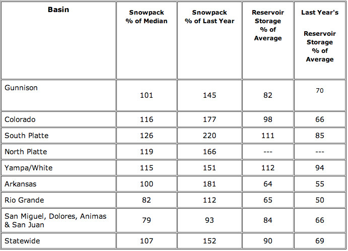
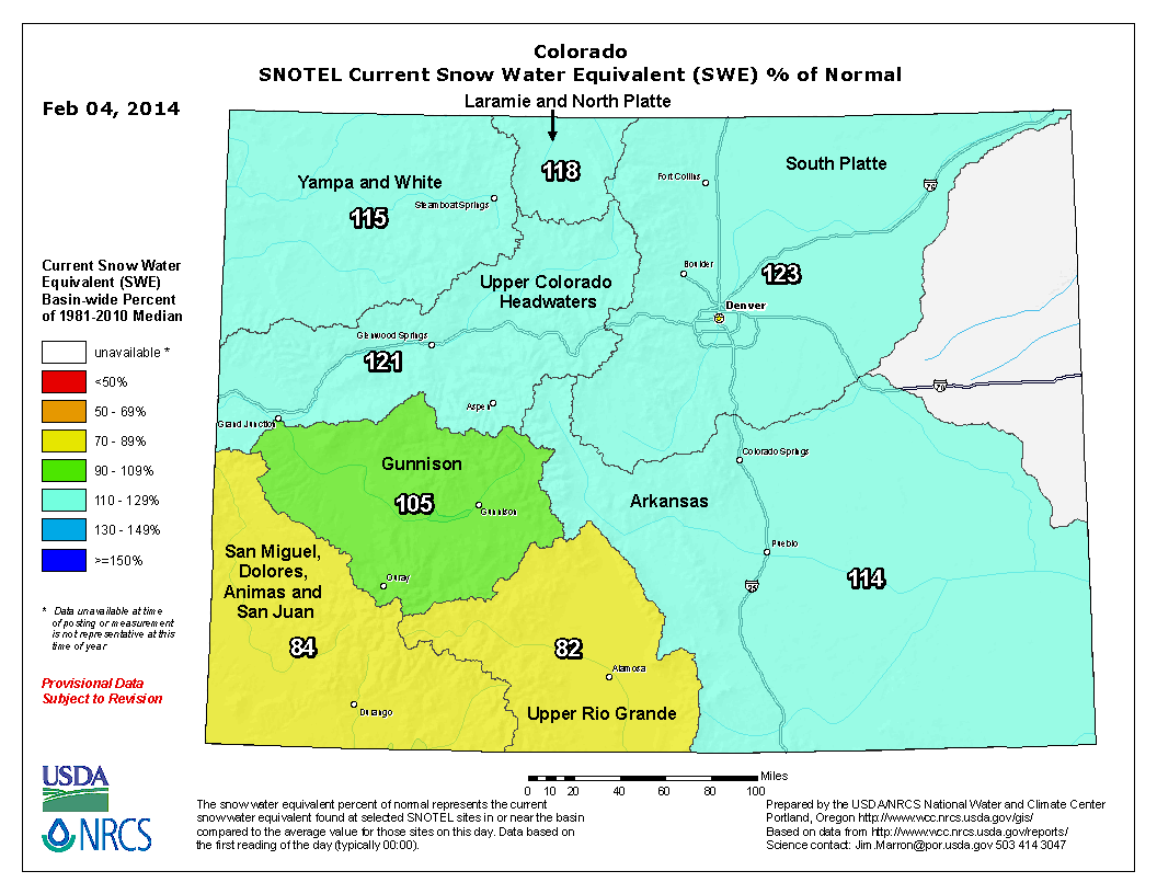
The faucet seemed to have turned off during the latter half of January, with most SNOTEL sites in Colorado recording very little snow accumulation during this time period. Thankfully a couple of significant storm systems moved through the state during the very last week of the month, just in time to boost the January totals. From January 27th to February 1st, snowpack totals measured at SNOTEL sites across the state increased from 95 percent to 109 percent of the median. In just one day, from January 30th to 31st the percentage jumped by 9 percentage points! Recent measurements at SNOTEL sites and snow courses across Colorado report the February 1 snowpack to be at 107 percent of the median. Phyllis Ann Philipps, State Conservationist with the NRCS stated, “This storm system benefited the entire state, but was especially needed in the southwest basins and the Upper Rio Grande basin. These areas had received very little snow since early in December and the recent moisture was a welcome change.”
While the snow received in the southwest and Upper Rio Grande was beneficial, it was not quite enough to boost the snowpack’s in these regions back to normal. These basins are the only basins in the state that reported below normal snowpack’s this month; 82 percent of median for the Upper Rio Grande and 79 percent of median for the San Juan basins. Across the rest of Colorado the February 1 snowpack’s range from 100 percent of median in the Arkansas basin to 126 percent of median in the South Platte.
Reservoir storage in Colorado has improved compared to last month. Statewide storage is currently at 90 percent of average with the South Platte and Yampa/White basins storing water at above average amounts for this time of year. Storage in the Arkansas and Upper Rio Grande basins remains well below average.
Expect the latest streamflow forecasts for the spring and summer season to improve compared to last month’s for the northern part of the state and to decline for the southwest and Upper Rio Grande.
Drought news

Click here to go to the US Drought Monitor website. Here’s an excerpt:
Summary
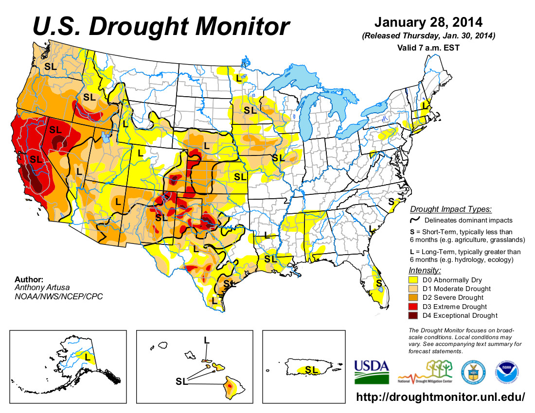
During the past 7-days, the persistent, amplified ridge that had dominated weather conditions across the western contiguous U.S. (CONUS) collapsed, which allowed Pacific storm systems to move eastward across the region. Moderate to heavy precipitation (0.5-3.0 inches liquid equivalent, locally heavier) was observed over the higher elevations of the Coastal Ranges, the Cascades, the Sierras, the Bitterroots, the Wasatch, and near the Colorado Front Range. Lower elevations across much of the West generally received light precipitation (0.5-inch or less), including the coastal areas of far southern California. Moderate to heavy precipitation (0.5-3.0 inches liquid equivalent, locally heavier) was also observed across portions of the Midwest, Ohio Valley, Great Lakes, southern New England, mid-Atlantic and southern Atlantic Coast states, Gulf Coast region, Tennessee Valley, Lower Mississippi Valley, and the ArkLaTex region. Temperatures during the past week were primarily below-normal east of the Continental Divide, and above-normal west of the Divide, though there were a few exceptions. East of the Divide, New England and Florida reported above-normal mean temperatures, while west of the Divide, Washington state was below-normal for the week…
Southern and Central Plains
Though light to moderate precipitation (under 2.0 inches) fell over parts of western, far southern, eastern, and northern Texas, many areas received little to no precipitation during the past week (though a few locations in the ArkLaTex region received 2-3 inches of rain). The precipitation that did fall helped to alleviate some of the short-term dryness. However, reservoirs along the Colorado River, as a whole, are at their lowest level (as a percent of normal) for this time of year ever, as is true of total water storage across the state. These factors prompted a number of 1-category improvements and degradations to the Texas drought depiction. In far western Oklahoma, extreme drought (D3) was expanded northward to include Roger Mills County. The latest precipitation event produced only about a tenth of an inch (radar estimated) from Roger Mills County southward across southwestern Oklahoma. There were a high number of days in January with extremely low relative humidity, mean temperatures close to normal, and wind. The January PNP was 20 percent of normal for the state as a whole (Mesonet), and the state-wide average precipitation was 0.29-inch. This was the 8th driest January on record. In Kansas, the state-wide average precipitation (PNP) for January was only 34 percent of normal. Reassessment of conditions will be needed next week after this current storm system passes through the area. In south-central Nebraska, a small drought-free area was downgraded to abnormal dryness (D0), in response to continuing dryness…
Southwest
Most of Arizona and New Mexico received little if any precipitation during the past 7-days. A predominantly dry pattern has been in place since the very beneficial and welcome late-season monsoon rains last September. Impacts are somewhat limited at this time due to lower evapo-transpiration (ET) rates during winter, but an increased snowpack in the next two months is needed to preclude more serious problems. SNOTEL Snow Water Equivalent (SWE), as of February 5, 2014, is mostly well below normal across the Mogollon Rim area (ranging from 14-41 percent), and in the White Mountains of eastern Arizona (SWE 26-36 percent of normal). The mountainous terrain of western and central Colorado received moderate to heavy precipitation (0.5-4.0 inches) during the past week, while the high plains of eastern Colorado generally received less than a half-inch of precipitation. As time is needed to evaluate regional impacts across the Southwest, it was decided not to alter the depiction this week…
The West
Though several inches of precipitation (liquid equivalent) fell over the northern one-half to two-thirds of California this week (locally 3-4 inches in the central Sierras), significantly more precipitation will be needed to justify improvement with the depiction. The central and southern Sierras report up to 4 inches of SWE, while the northern Sierras report only an inch. The precipitation received this week only keeps the snowpack/water supply from falling further behind. Reservoirs continue to go down. An 8-station index for the northern Sierras (which represents an average of 8 precipitation gauges that span the area from Lake Tahoe to up above Lake Shasta), indicates precipitation amounts of 4.5 inches since the beginning of the Water Year (Oct 1). Last year at this time, 34.3 inches of precipitation fell, while the average to date is 26.4 inches. The only change to the depiction in California this week was to slightly increase the coverage of exceptional drought (D4) conditions across most of San Luis Obispo County. Two of the larger reservoirs in the County, near the border with Monterey County, are at 5-percent capacity (Lake Nacimiento and Lake San Antonio). The City of Cambria is implementing water restrictions for residents, while many cattle owners are selling off their herds due to lack of feed and water. The higher elevations of western Washington and western Oregon received 2-5 inches of precipitation (liquid equivalent, locally heavier) during the past week, though as is the case with California, significantly more precipitation will be needed to overcome longer-term deficits. Finally, in western Montana, the valley areas have been fairly dry recently, while the mountainous areas have received significant precipitation. Given support from the latest short-term and long-term drought blends, and the recent dryness (ACIS 30-day and 60-day PNPs ranging from about 20-50 percent of normal in this area), the drought-free area in southwestern Montana was downgraded to abnormal dryness (D0)…
Looking Ahead
During February 6-10, 2014, very heavy precipitation (as much as 7-9 inches, liquid equivalent) is predicted in northern California, and 3-4 inches in western Oregon. This will go a long way in helping to mitigate some of the drought conditions in these areas, though reassessment of conditions next week will be needed to determine the extent of any potential improvements in the Drought Monitor depiction. Along the Southeast coast including northern Florida, 1.0-1.5 inches of rain is expected during the period which will be beneficial to the small areas of abnormal dryness (D0) in that region. With the exception of 3-4 inches of precipitation anticipated over the central Rockies and Wasatch Range, most other areas of the CONUS can expect a half-inch or less of precipitation within the next 5 days.
For the ensuing 5-day period, February 11-15, 2014, there are elevated odds of above-median precipitation for most of the northern and eastern Lower 48 states, and the Alaska Panhandle. Probabilities for above-median precipitation rise up to 60-percent in the Pacific Northwest, and 50-percent over the Gulf and Atlantic Coast states. Below-median precipitation is favored for southern California, much of the Southwest and southern Rockies, the central and southern High Plains, and most of Alaska.
Snowpack news: ‘We can rejoice locally but we have to understand the bigger picture, too’ — Jim Pokrandt
From The Grand Junction Daily Sentinel (Dennis Webb):
Just a week ago, Colorado’s early-season cushion of winter snowpack had evaporated, with the state dropping to 93 percent of median levels, down 10 percent from the start of the year. That was then, before a snowstorm that delivered two and in some areas even three feet of snow in the central mountains. A storm that delivered what many have called epic powder amounts to many ski areas also rapidly restored the state snowpack level. As of Monday it was at 107 percent of median, said Mage Hultstrand, assistant snow survey supervisor for the Natural Resources Conservation Service in Colorado.
And that was just last week. As much as two feet of additional snow could fall this week between the eastern portion of the Grand Mesa and the Elk and northern West Elk Mountains in the Aspen-to-Crested-Butte area, thanks to a new storm pattern that moved in Sunday night, said Joe Ramey, a National Weather Service meteorologist in Grand Junction. That storm brought an additional five inches of snow to Powderhorn Mountain Resort by Monday morning, the resort reported.
Recent days have brought a welcome change after a prolonged dry stretch in January.
“By mid-January things had dried up pretty good,” Hultstrand said.
But the storm late last week provided a “huge boost” to snowpack, she said.
The Upper Colorado River Basin, which was at 105 percent of median snow-water-equivalent as of Jan. 27, soared to 120 percent by Monday.
The Gunnison River Basin rose in a week from 91 percent to 103 percent of median.
Unfortunately, winter’s bounty has yet to extend enough to the southwest part of the state. The Upper Rio Grande Basin and the combined San Miguel, Dolores, Animas and San Juan basins are both at just more than 80 percent of median. But the Rio Grande was at 68 percent, and the others were at 71 percent, just a week earlier.
Hultstrand said the Upper Colorado’s average is so good that it could afford to get just 68 percent average snowfall for the rest of the snow season to reach average peak.
But southwest Colorado’s dearth of snow, not to mention a major drought in California, continue to worry water-watchers including Jim Pokrandt, spokesman for the Colorado River Water Conservation District in Glenwood Springs. His concern is both how much snowmelt ends up flowing into the Colorado River more regionally this spring and how much demand there will be for it downstream.
“We can rejoice locally but we have to understand the bigger picture, too, and the bigger picture isn’t as rosy as we’re enjoying,” he said.
Ramey said a high pressure ridge close to the Pacific coast has lingered since around early December, acting as a wall that has forced storms to the north and over it, and leaving California, Arizona, New Mexico and the Four Corners area drier. The good news is that that pattern seems to be breaking down, bringing the promise of moisture to that region, including southwest Colorado, this week, he said.
He said storms early and later this week should favor all of western Colorado before things dry out over the weekend.
Roaring Fork Watershed snowpack is at 119% of normal today! http://t.co/u4vaAsYT6g
— RoaringFkConservancy (@rfconservancy) February 6, 2014
The COGCC explores expanded policy for horizontal drilling ‘communication’ with existing wells

From The Grand Junction Daily Sentinel (Dennis Webb):
The Colorado Oil and Gas Conservation Commission plans to expand statewide a policy aimed at preventing horizontal wells from causing leaks involving existing wells, due to a leak southwest of De Beque where such a possible link is being investigated.
The Bureau of Land Management also is looking at what it can do to try to help head off such problems.
The agencies’ actions follow the Dec. 14 discovery of natural gas and fluids bubbling up around a Maralex Resources well on Jaw Ridge, which is BLM-managed land about seven miles from De Beque. The leak’s cause continues to be investigated, and one possibility the COGCC is considering is that it resulted from hydraulic fracturing of a Black Hills Exploration & Production well that was drilled from a surface site about a mile away, but made a 90-degree turn underground and passed within about 400 feet of the Maralex well.
The Maralex well was drilled in 1981 but was shut in shortly after its drilling. It stopped leaking Jan. 17, as work continued on permanently plugging it, an effort completed a week later. Fluids initially escaped from the well pad after the leak’s start. Maralex then opened the well and directed the flow into a pit for removal by truck. That flow fluctuated widely but averaged about 6,300 gallons a day during the month before it ceased. Authorities have found no indication of contamination of surface water or groundwater. Testing continues to try to determine exactly how far the fluids spread beyond the pad within what the BLM considers to be a known maximum spill parameter.
‘COMMUNICATION’ CONCERN
The COGCC currently has a policy aimed at preventing what it calls the potential for “communication” between horizontal wells and existing wells in 11 counties in eastern Colorado’s Denver-Julesburg Basin. That area is seeing a boom in horizontal drilling aimed at producing oil and other liquids, in an area with numerous existing vertical wells that in some cases may not have been constructed to withstand modern-day, high-pressure fracture operations nearby.
“It is apparent that that policy needs to be pushed out statewide. It needs to be pushed out statewide very quickly,” COGCC director Matt Lepore told the commission at its last meeting.
The policy requires the COGCC engineer to evaluate all wells within 1,500 feet of a proposed horizontal wellbore to determine whether the existing wells have adequate cement sealing around them to isolate the geological formation to be fractured, as well as all groundwater zones. Also to be evaluated is whether an existing well’s wellhead and master valve are rated to 5,000 pounds per square inch of pressure, or alternatively that there is adequate mechanical isolation down the well.
If concerns exist regarding an existing well, the company proposing the horizontal well must take measures that can range from doing remedial cement work in the existing well to isolate all formations, to properly plugging it, to replugging it if needed or proposing alternative mitigation. An existing well’s owner cannot refuse to let mitigation work occur.
The COGCC initially implemented the policy for horizontal wells coming within 300 feet of existing wells. It eventually expanded the distance after pressure readings and other data collected at existing wells during fracking of new ones indicated a need to do so.
Lepore told the commission one concern companies have is the lack of data that would justify the 1,500-foot-distance standard in the case of wells outside the DJ Basin. He also noted that there are currently few plans to drill horizontal wells elsewhere in the state. Companies have been drilling a small number of such wells for exploratory purposes in the Piceance Basin.
LEAK THEORY INVESTIGATED
The Maralex well was drilled into the Dakota sandstone formation, while the Black Hills well targeted the Niobrara shale, part of the shallower Mancos formation. The COGCC says the Maralex well wasn’t cemented to isolate the Niobrara zone because that zone wasn’t considered a producing formation when the well was drilled. It’s looking at whether gas liberated from fracking the Black Hills well reached the Maralex well, pushing gas and water to the surface.
Bruce Baizel, energy program director with the Earthworks conservation group, has said another concern in horizontal drilling is that it may occur around older existing wells that may have corroded pipes or cement sealing that has weakened over time and can’t stand up to fracking pressures.
Maralex plugged its well in stages after the discovery of the leak. When it finished plugging the Dakota sandstone formation, the leak slowed but continued. The leak stopped once plugging was completed at the top of the Mancos formation. But that in itself hasn’t been enough to convince officials that the Black Hills well fracking caused or contributed to the problem.
Test results of fluid that flowed back from the Black Hills well are still being awaited. Samples of flowback fluid from another Black Hills horizontal well farther from the Maralex well proved to differ significantly from the fluid that came up the Maralex well.
THE BLM’S ROLE
Agency spokesman Steven Hall called the Maralex situation a rare one for the BLM, which he believes has seen few instances where fracking has occurred close to shut-in wells on lands it administers in Colorado. While noting that the leak’s cause hasn’t been determined, he said the BLM wants to do what it can to prevent problems between horizontal and existing wells. He said the BLM is reviewing how it manages horizontal drilling and fracking on federal land in the state. The agency has no rules or policies addressing potential communication between horizontal and existing wells. But Hall said it has a lot of leeway during the process of reviewing drilling permit applications to impose conditions to try to avoid such situations. In addition, it is working to deal with the situation of wells that are shut in for a long time, to make sure they are permanently plugged, put into production, or tested to ensure their integrity.
“We’re going to try to be very aggressive in addressing those,” Hall said.
The agency previously has said that of 110 wells Maralex owns that involve federal lands or minerals in western Colorado, 86 are shut-in — in nearly half those cases for more than 20 years. It has met with Maralex about coming up with a strategy for addressing its shut-in wells.
Drought news: Colorado Springs Utilities is breathing easier and keeping one eye on the sky #COdrought
From KOAA.com (Bill Folsom):
So far this year snow is driving away drought in much of Colorado.
“We have a much more positive outlook going into 2014 than we had last year,” said Colorado Springs Utilities, Water Supply Planning Supervisor, Abby Ortega.The national drought map now shows most of Colorado under “abnormally dry” conditions. It is an upgrade of several levels, from the “extreme drought” designation across most of the state last year.
There is optimism among water managers, but also caution. Snowpack is deeper than the 30 year average, but Ortega points out that this is just the start of the snow season. She says March and April are typically the months when the most significant moisture falls in Colorado. She also says we are still in a water deficit. “We’re certainly optimistic. We’re looking at the snowpack but in addition we need to keep in mind that after the last two years of dry conditions our reservoir storage is well below normal.”
Republican River Basin: Colorado begins moving water through the Compact Compliance Pipeline

From the Imperial Republican (Russ Pankonin):
With the go-ahead from Kansas, Colorado began pumping water from their northeast Colorado augmentation project. The Compact Compliance Pipeline (CCP) started delivering water to the North Fork of the Republican River on Friday, Jan. 17, according to Deb Daniel, manager of the Republican River Water Conservation District (RRWCD) in Wray, Colo.
Daniel said the CCP is scheduled to deliver approximately 4,000 acre feet of water prior to April 1. This should put Colorado in compliance with the 2003 Republican River Compact Settlement with Kansas.
In late summer 2014, Colorado will calculate if the state will be in compliance depending on weather conditions and the amount of water that is pumped in the basin during the summer months.
If additional water is required, the pipeline will deliver the necessary acre feet to be in compliance with the compact, prior to the end of 2014, Daniel said…
Daniel said the current well field, which consists of eight wells, has an annual capacity of around 15,000 acre feet. She said they plan to add seven more in the future.
RRWCD purchased the water rights to 58 irrigation wells in eastern Yuma County. The appropriations from these wells were transferred to the new well field, she said.
Water delivered by the pipeline is measured in the channel just prior to the water flowing into the river. The water passes through an open concrete flume equipped with a measuring device to calculate the amount of water delivered to the river.
Each of the wells are also equipped with flow meters to measure the amount pumped. RRWCD can pump no more from the well field than the historic consumptive use of the 58 wells.
2014 #COleg SB14-115: ‘The current process already allows for legislative input’ — The Pueblo Chieftain

The Pueblo Chieftain editorial staff weighs in on SB14-115:
Some Colorado lawmakers want the final say on how the state uses its limited water resources. Senate Bill 115 has been introduced and elected officials from both political parties have signed up as sponsors. The measure, if approved, would give the Colorado Legislature the authority to adopt a state water plan. In many states that have approved water plans, legislatures were the public body that developed them.
Here in Colorado, however, the details of the emerging state water plan are being debated by the nine basin roundtables, which were formed nine years ago and help guide water policy through grass-roots involvement.
According to James Eklund, director of the Colorado Water Conservation Board, the need for a state water plan is acute. As the state expects population growth to continue for decades ahead, it makes sense that we figure out how to best allocate our water.
That’s why Gov. John Hickenlooper issued an executive order in 2013 setting a deadline of December 2015 for the drafting of a strategic water plan for the entire state.
During a water policy briefing Tuesday in Pueblo, Eklund said many water policy experts think that the state’s plan “needs to be built from the bottom up.” That’s why the current roundtable process makes the most sense, he said. We completely agree.
In Colorado, water is our most important resource and we shouldn’t turn over the question of its ultimate use to politicians. Because of its Denver-centric power base, the Legislature too often leans away from rural and agricultural interests. To allow Denver politicians control of all water policy is potentially dangerous to other parts of the state.
On the roundtable level, there is an opportunity for more diverse opinions to be shared and thus more buy-in from the stakeholders throughout Colorado. Here in Southern Colorado, we place a high priority on efforts to place conservation easements on farms and ranches to tie water to the land. We also encourage proposals to restrict the further transfers of water outside the basin. Other regions of the state have different priorities and each deserves a voice at the table.
Promoting a feeling of “we’re all in this water fight together” is important as a state water plan is finalized. Residents outside of the Denver metro area don’t need another example of urban interests — such as Aurora, which has acquired a quarter of their total water supply from the Arkansas Valley — dictating the future direction of Colorado policies.
The current process already allows for legislative input as the plan is developed. There is no reason for that body to dominate the public discourse and decision making on the matter, however.
More 2014 Colorado legislation coverage here.
New Hydraulic Fracturing Report Finds Texas and Colorado Face Biggest Water Sourcing Risks

Here’s the release from CERES via CSRWire:
As hydraulic fracturing is increasingly used for oil and gas extraction across much of the United States and Western Canada, a new Ceres report issued today shows that much of this activity is happening in arid, water stressed regions, creating significant long-term water sourcing risks for companies operating in these regions as well as their investors.
The report provides first-ever data on oil & gas companies’ water use and exposure to the most water stressed regions, including those in Texas, Colorado and California. It includes recommendations for companies to improve their water management and reduce their overall exposure to water sourcing risks.
“Hydraulic fracturing is increasing competitive pressures for water in some of the country’s most water-stressed and drought-ridden regions,” said Ceres President Mindy Lubber, in announcing Hydraulic Fracturing and Water Stress: Water Demand by the Numbers. “Barring stiffer water-use regulations and improved on-the-ground practices, the industry’s water needs in many regions are on a collision course with other water users, especially agriculture and municipal water use. Investors and banks providing capital for hydraulic fracturing should be recognizing these water sourcing risks and pressing oil and gas companies on their strategies for dealing with them.”
The report is based on water use data from 39,294 oil and gas wells reported to FracFocus.org from January 2011 through May 2013 and water stress indicator maps developed by the World Resources Institute (WRI). It shows that nearly half of the wells were in regions with high or extremely high water stress. (Extreme high water stress regions, as defined by WRI, are areas where 80 percent of available surface and groundwater are already allocated to municipal, industrial and agricultural users.) Continue reading “New Hydraulic Fracturing Report Finds Texas and Colorado Face Biggest Water Sourcing Risks”