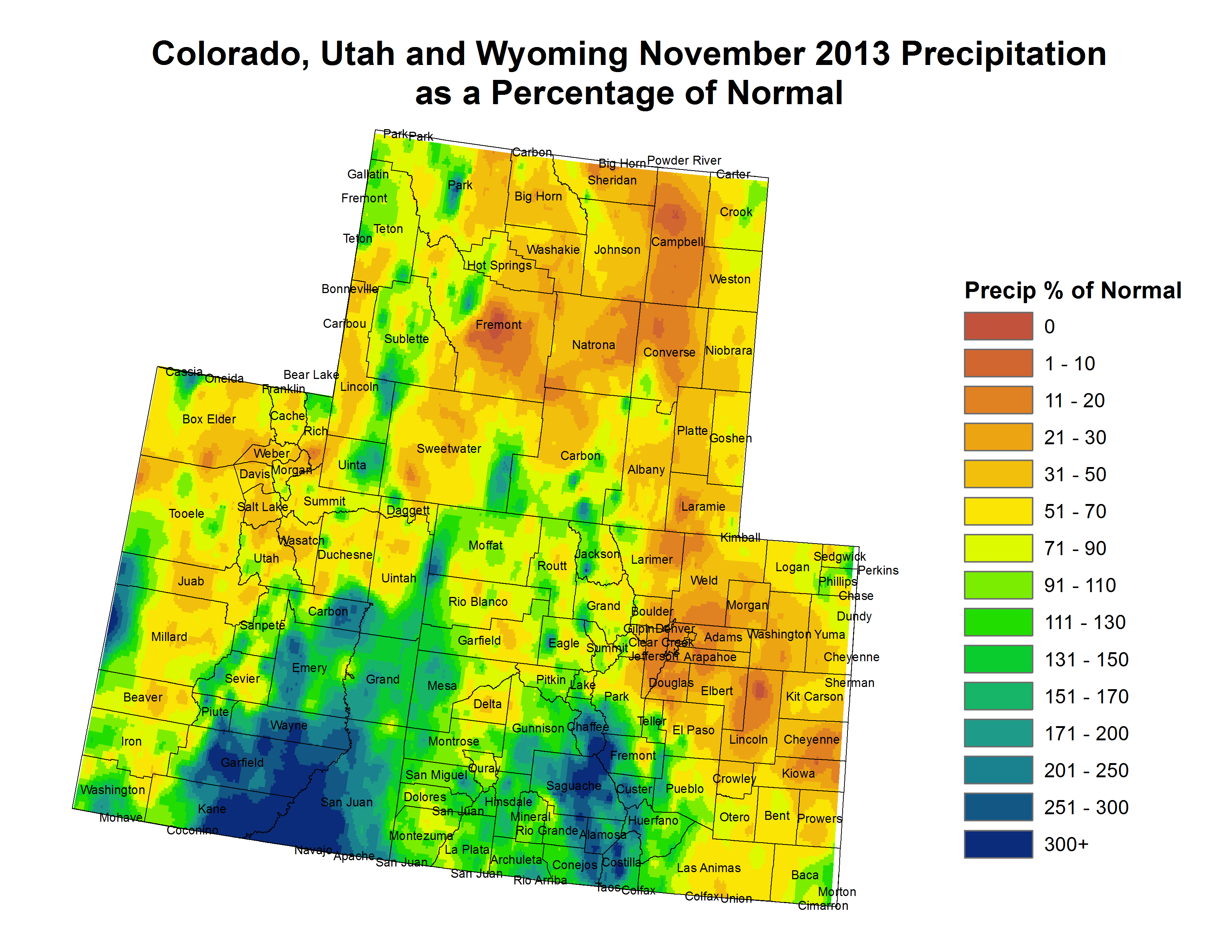
Click here to read this week’s assessment. Click here to go to the NIDIS Upper Colorado River Regional Drought Early Warning System website from the Colorado Climate Center.

Click here to read this week’s assessment. Click here to go to the NIDIS Upper Colorado River Regional Drought Early Warning System website from the Colorado Climate Center.
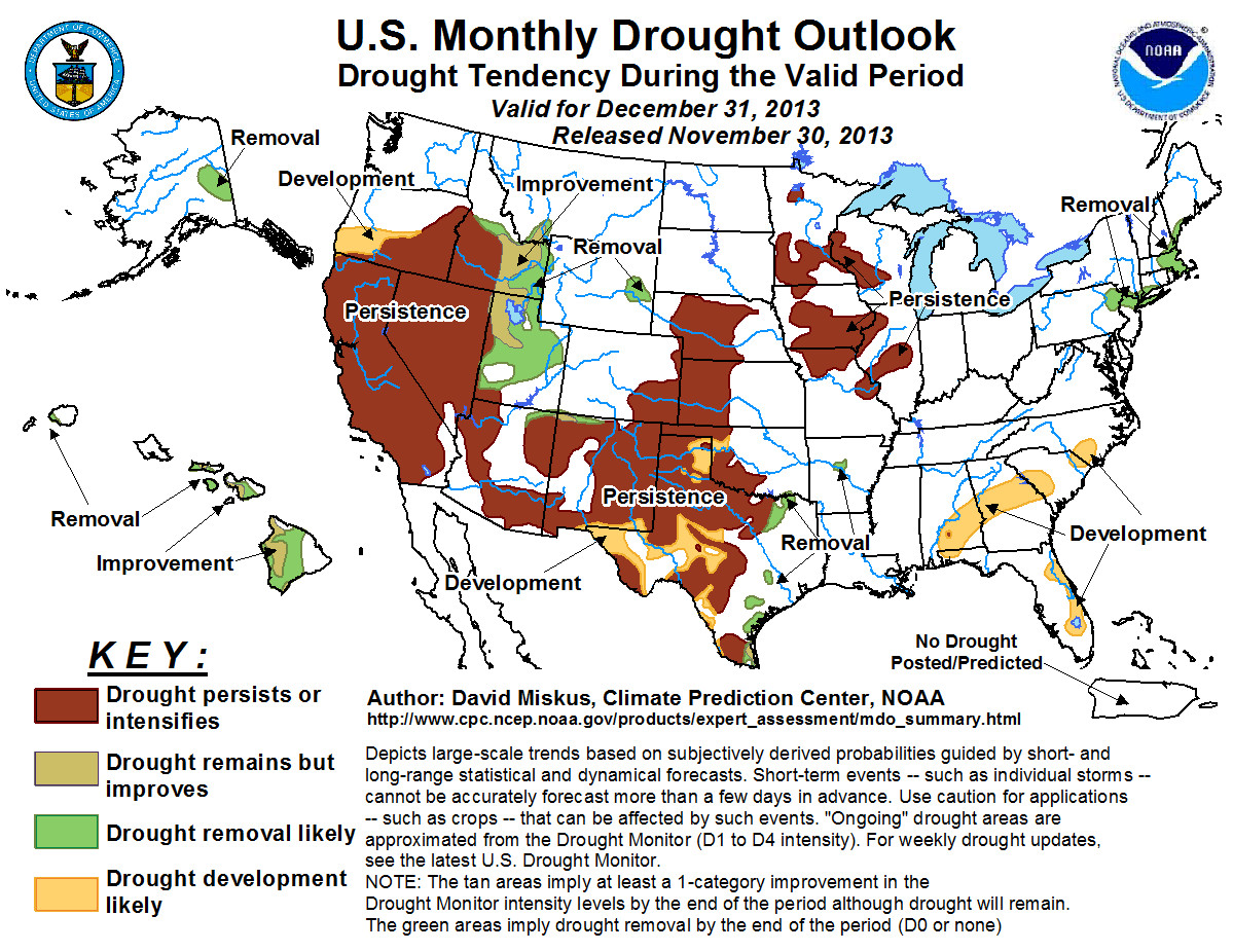
Click here to go to the Climate Prediction Center Website.

From The Denver Post (Monte Whaley):
A Dec. 1 deadline to reopen 27 flood-battered Colorado highways was tame compared with the years of complex challenges facing road crews charged with making permanent fixes to damage caused by September’s historic floods. The magnitude of the task is still being assessed while highway managers consider the types of technological and engineering changes they need to make to keep 485 miles of damaged roadway less vulnerable to mass flooding. It may take the Colorado Department of Transportation as long as 48 months to finish the permanent repairs needed on formerly flooded roads, said Johnny Olson, CDOT’s incident commander for the state’s infrastructure recovery force.
“We were charged with getting residents reconnected with their communities by getting these roadways done, and done to ensure safety by Dec. 1, and we did that,” said Olson. “Now we have to go back and evaluate and make repairs based on the long term.”
By Dec. 31, CDOT should have a pretty good idea of what needs to be done. By next spring, work could start on permanent “early out” projects where there was relatively minor damage to roadways. But on larger sections of highway — including U.S. 34 in Big Thompson Canyon — evaluations will take much longer and the work will be more detailed and challenging, Olson said. That road is getting particular attention since it was destroyed by the 1976 Big Thompson Flood and rebuilt to supposedly withstand another catastrophic flood.
“It was built to be indestructible,” said Gov. John Hickenlooper. “You see that it is very hard to be indestructible.”
Options weighed
CDOT Executive Director Don Hunt said engineers are weighing two possible options for the permanent rebuilding of U.S. 34 — reconstructing a road that will hold up against nearly any kind of flood or building a less expensive, but more vulnerable, highway. Those questions and others could be answered over the next few months, Olson said.
For example, he said: “What can we do to prevent this curve from washing out? What kind of striping does this stretch need? And what can we put under the surface of the roadway to make it last?”
Residents shouldn’t expect complete makeovers to damaged highways, said Olson. That’s because funding for repairs — including $450 million in state and federal funds — must be spent on specific damages. About one-third of the $450 million has been spent on temporary fixes, leaving the rest for permanent work, said Hunt.
It’s not clear if more funding will be available to Colorado in the near future, CDOT spokeswoman Mindy Crane said.
“Wherever there is damage, we can look at improving standards to protect us in the future,” Olson said. “But we can’t go through the whole U.S. 34 corridor and make changes.”
County roads crews also face months, or maybe years, of repairs due to the flooding.
“Hopefully, in some areas, we will be able to do permanent construction this summer,” said George Gerstle, transportation director in Boulder County, where the flood ravaged roads into mountain communities and a key segment of Colorado 7 between Lyons and Allens-park. “Others may take another year for design and construction because of the magnitude of the damage.”
County road crews rebuilt some 30 miles of canyon roads in about two months to make them passable, including Sunshine Canyon and Flagstaff Road, Gerstle said. Still, many county roads and bridges suffered heavy damage from creeks leaving their banks and establishing new channels. Crews will be busy doing temporary repairs on many of those areas over the next several months, including Lee Hill Road, Olde Stage Road, Apple Valley Road, Lickskillet Road and Longmont Dam Road. And while that work is going on, the county is looking at designs that will make bridges and roads less vulnerable to major floods that are likely to hit again.
“We are doing significant analysis on how we can construct roads and bridges that can withstand major flooding, which will come sometime in the future,” Gerstle said.
About 35 miles of Larimer County roads were destroyed in the flooding, but now 85 percent are back in operation, said Larimer County Commissioner Tom Donnelly. Officials expect the final miles of County Roads 43, 44H, 47 and 63 to open by Dec. 13.
But there may be bigger issues in Big Thompson Canyon, where seven of the canyon’s 17 bridges are owned by the county and all suffered heavy damage, Donnelly said. Most of the damage was caused by debris from the river that got plugged and overloaded the bridge infrastructure, he said. The county is looking to replace those with bridges that tilt and shrug off the rocks and tree branches that come with flooding, Donnelly said.
“In the long term, we want to be in a better position with our roads and bridges than where we are now,” he said.
Praise for progress
Still, he credits county crews, who worked in tandem with CDOT and contractors, for making formerly impassable roads, passable.
“We had 35 miles of roads destroyed in the flood, and now 85 percent are back in operation,” Donnelly said. “That’s impressive.”
Estes Park Mayor William Pinkham said some major restoration work will probably be needed on U.S. 36 near Pinewood Springs.
Otherwise, most residents are pleased with the temporary fixes along U.S. 34. “If you haven’t driven that road before, you never would have realized it’s a brand new road,” he said.
Mark Milburn, who lives near Allenspark, cheered with others last week when Hickenlooper cut the ribbon on Colorado 7 to reopen the road to Lyons. He, too, praised the speed of contractors and CDOT to get the work done so he could reunite with friends in Lyons. But Milburn worried that shoulders and turnouts on the highway won’t be restored.
“I know they were washed away by the floods, but for safety sake, I hope they will be returned,” Milburn said.
His wife, Sharon Milburn, also wished those huge concrete blocks known as Jersey barriers that funneled traffic away from road crews will disappear soon.
“It would be nice to see them go,” she said. “It would improve the view.”

Click here to read the newsletter.

From email from the Colorado River District (Martha Moore):
Effective immediately, the Colorado River District is accepting grant applications for projects that protect, enhance or develop water resources within its 15-county region. (district map)
Projects eligible for the grant program must achieve one or more of the following objectives:
• develop a new water supply
• improve an existing system
• improve instream water quality
• increase water use efficiency
• reduce sediment loading
• implement a watershed management action
• control invasive riparian vegetation
• protect pre-Colorado River Compact water rights (those in use before 1929)Previous successfully grant-funded projects have included the construction of new water storage, the enlargement of existing water storage or diversion facilities, rehabilitation of nonfunctioning or restricted water storage / delivery / diversion structures, implementation of water efficiency improvements and watershed enhancements.
Successful grantees can receive up to a maximum of $150,000 (or approximately 25% of the total project cost; in the case of smaller projects, this percentage may be slightly higher) for their project. The total amount available for the 2014 competitive grant program is $250,000. The application deadline is Jan. 31, 2014.
To access the Water Resources Grant Program application, instructions, guidelines, policies, and other details please visit http://www.ColoradoRiverDistrict.org/page_193.
More information can be obtained by contacting Dave Kanzer or Alesha Frederick at 970-945-8522 or by e-mail to grantinfo@crwcd.org.
More Colorado River District coverage here.

From the Grand Junction Daily Sentinel (Greg Ruland):
Get those skis and boards waxed, the season is about to start. Powderhorn Mountain Resort is making plans to open at 9 a.m. on Saturday, five days ahead of schedule thanks to the best early season snowfall in years, General Manager Sam Williams said.
“Mother Nature has blessed us with great early season conditions and cold temperatures,” Williams said.
News of the opening was first announced on the resort’s Facebook page on Monday, and news quickly spread via Twitter and other social media.
Persistent cold has allowed the resort to manufacture base conditions, but early precipitation is what will make the early opening possible, he said. More than 30 inches awaits skiers at the top of Grand Mesa, where wintertime is definitely underway, Williams said, adding that the base area could use more to be fully ready.
Help from Old Man Winter may arrive soon to take care of that.
“We got word from the National Weather Service that we’re probably going to receive another at least 12 inches of snow this week, which will give us the base we need to open,” he said.
That extra snow will allow the resort to open many of its runs earlier than usual, Williams said…
Across the state, several other resorts have already started their seasons, some just this week, including Telluride, Crested Butte, Purgatory, Steamboat and Aspen/Snowmass, according to Colorado Ski Country USA.
Sunlight Mountain Resort in Glenwood Springs is scheduled to open this weekend.
From the Glenwood Springs Post Independent (Hannah Holm):
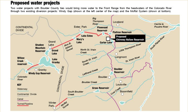
Denver can take a little more water from the Colorado River’s headwaters to increase the reliability of its system, but won’t develop any new transmountain diversions without West Slope agreement and will help repair damage from past diversions.
Those are some of the key provisions in the Colorado Cooperative Agreement between Denver Water and 42 West Slope water providers and local governments from the Grand Valley to Grand County.
The Colorado Cooperative Agreement covers a whole suite of issues related to Denver’s diversion of water from the Fraser and Blue River drainages, tributaries to the Colorado River. In October, with little fanfare, this historic agreement received its final signatures and was fully executed. It took five years of mediation and nearly two years of ironing out the details with state and federal agencies, against a backdrop of decades of litigation, to get to this point.
According to material from the Colorado River District’s latest quarterly meeting, the agreement, “is the direct result of Denver Water’s desire to expand its Moffat Tunnel transmountain water supply from the Fraser River in Grand County and to enlarge Gross Reservoir in Boulder County.” This project is expected to divert, on average, approximately 18,000 acre feet/year of water beyond the average of 58,000 acre feet/year it already diverts, which amounts to about 60% of the natural flow in the Fraser River at Winter Park.
Under the agreement, the West Slope parties agreed not to oppose the increased Moffat Collection System diversions, and Denver Water agreed not to expand its service area and not to develop new water projects on the West Slope without the agreement of the resident counties and the Colorado River District. The agreement also includes dozens of other provisions designed to limit water demands in Denver and address water quality and flow conditions in the Colorado River and its tributaries. Here’s a sampling:
Denver will contribute both water releases and several million dollars for a “learning by doing” project to improve aquatic habitat in Grand County. The project will be managed by representatives from Denver Water, Grand County, Colorado Parks and Wildlife, Trout Unlimited and other water users.
Denver will not exercise its rights to reduce bypass flows from Dillon Reservoir and its collection system in Grand County during droughts unless it has banned residential lawn watering in its service area.
Diversions and reservoirs operated by both Denver Water and West Slope parties will be operated as if the Shoshone hydroelectric power plant in Glenwood Canyon were calling for its (very senior) water right, even at times when the plant is down. This is important for recreational and environmental flows in the river, as well as for junior water users downstream from plant.
Denver Water will pay $1.5 million for water supply, water quality or water infrastructure projects benefiting the Grand Valley, and $500,000 to offset additional costs for water treatment in Garfield County when the Shoshone call is relaxed due to drought conditions.
A similar agreement is under development between West Slope entities and Northern Water, which currently diverts about 220,000 acre feet/year of water from the Upper Colorado River to the Front Range through the Colorado Big Thompson Project. Like the Colorado Cooperative Agreement, the Windy Gap Firming Project Intergovernmental Agreement trades West Slope non-opposition to increased transmountain diversions for mitigations to address the impacts of both past and future stream depletions.
Both the Colorado Cooperative Agreement and the Windy Gap Firming Project Intergovernmental Agreement have been hailed as models of cooperation. Meanwhile, East Slope – West Slope tensions continue to mount over how the Colorado Water Plan, currently under development, should address the possibility of additional diversions of water from the West Slope to meet growing urban demands on the Front Range. These agreements demonstrate that such tensions can be overcome, but also that it could take more time than allowed by the 2015 deadline Gov. Hickenlooper has set for completion of the Colorado Water Plan.
Full details on the Colorado Cooperative Agreement can be found on the River District’s website, under “features” at http://www.crwcd.org/. More information on the Colorado Water Plan can be found at http://coloradowaterplan.com/.
More Colorado River Cooperative Agreement coverage here.