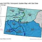
Statewide Snowpack Map December 10, 2013 via the NRCS
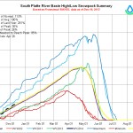
South Platte Basin High/Low graph December 10, 2013 via the NRCS
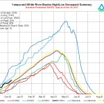
Yampa/White Basin High/Low graph December 10, 2013 via the NRCS
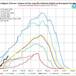
San Juan/Animas/Dolores/San Miguel Basin High/Low graph December 10, 2013 via the NRCS
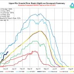
Rio Grande Basin High/Low graph December 10, 2013 via the NRCS
North Platte Basin High/Low graph December 10, 2013 via the NRCS
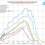
Gunnison Basin High/Low graph December 10, 2013 via the NRCS
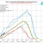
Colorado River Basin High/Low graph December 10, 2013 via the NRCS
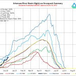
Arkansas Basin High/Low graph December 10, 2013 via the NRCS
Mage at the NRCS was really busy yesterday. Click on the thumbnails to see the current snowpack graphs and statewide map.