Weekly Climate, Water and Drought Assessment of the Upper #ColoradoRiver Basin #COdrought

Upper Colorado River Basin precipitation as a percent of normal July 2014 via the Colorado Climate Denver

Click here to read the current assessment. Click here to go to the NIDIS website hosted by the Colorado Climate Center.

From KRDO (Zach Pagano):

New numbers from the U.S. Drought Monitor suggest more than half of Colorado is drought-free.

This is significant improvement over this time last year, when nearly the entire state was in some sort of drought condition.

Dan Hobbs owns Hobbs Family Farm, in Avondale. He says farming in southern Colorado hasn’t always been easy.

“The last 14 years, on balance, have been pretty challenging due to the dry conditions,” Hobbs said.

But it appears help may be on the way for Hobbs and his fellow farmers. Heavy rainfall is bringing places, such as Pueblo County, out of the “exceptional drought” category.

“We’ve had some fun problems, and that’s more water than we can actually use,” Hobbs said. “It’s a good problem to have.”

For portions of southeast Colorado, drought fears are far from over.

“It takes a long time to get into a drought, and it takes a long time to get out of a drought,” said National Weather Service meteorologist Paul Wolyn.

Hobbs says he understands how vital precipitation can be to agriculture.

“It’s a precious resource, and to the extent possible, we need to figure out solutions to keep that water on the land so we can keep feeding the people of Colorado,” said Hobbs.

CIRES Report: Climate Change in Colorado A Synthesis to Support Water Resources Management and Adaptation

climatechangeincoloradociresaugust2014

Click here to read the executive summary. Here’s an excerpt:

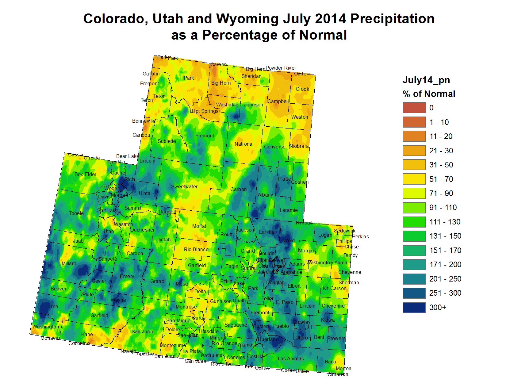
In the past 30 years, Colorado’s climate has become substantially warmer. The recent warming trend in Colorado is in step with regional and global warming that has been linked to increasing atmospheric concentrations of greenhouse gases. Annual precipitation, which has high natural variability, has not seen a statewide trend over that period. However, some drought indicators have worsened due to the warmer temperatures.

As greenhouse gases and other human effects on the climate continue to increase, Colorado is expected to warm even more by the mid-21st century, pushing temperatures outside of the range of the past century. The outlook for future precipitation in Colorado is less clear; overall increases or decreases are possible. The risk of decreasing precipitation appears to be higher for the southern parts of the state.

The future warming is projected to generally reduce Colorado’s spring snowpack, cause earlier snowmelt and runoff, and increase the water use by crops, landscaping, and natural vegetation. While future increases in annual natural streamflow are possible, the body of published research indicates a greater risk of decreasing streamflow, particularly in the southern half of the state.

From TheDenverChannel.com (Phil Tenser, Mike Nelson):

Colorado’s warming climate is projected to cause significant changes for state’s water supply, according to a new study.

Released by the Western Water Assessment and the Colorado Water Conservation Board, the study echoes many of the predictions included in a national assessment issued by the federal government in May. Both forecast that ongoing warming of the local climate will reduce Colorado snowpack, cause earlier snowmelt and increase water use for agriculture and landscaping.

“Climate Change in Colorado,” the report issued Tuesday and led by a University of Colorado researcher, is based on compiled climate science. It focuses on current observed trends and forecasts for the mid-21st century…

The authors also stated that Colorado snowpack has been mainly below-average since 2000 and snowmelt timing has shifted earlier in the spring over the past 30 years. Projections call for the peak runoff time to continue shifting earlier, but the report says that changes in the timing are more certain than predictions for the amount of runoff.

The report says, “The uncertainty in projections of precipitation and streamflow for Colorado should not be construed as a ‘no change’ scenario, but instead as a broadening of the range of possible futures, some of which would present serious challenges to the state’s water systems.”

According to the report, these observations and predictions could influence reservoir operations including flood control and water storage. Changes in the timing and volume of runoff may also “complicate” future water rights issues and interstate water compacts. Lower streamflows could also lead to higher concentrations of pollutants.

Earlier peak flows could have impacts on aquatic ecosystems and rafting or fishing industries, while reduced snowpack may also impact Colorado mountain tourism.

Every climate model assessed in the report indicates future warming will increase average annual temperatures by 2.5 to 5 degrees Fahrenheit by 2050 if greenhouse gas emissions are in the lower range of estimates. If emissions are in a higher range, the increase could be 3.5 to 6.5 degrees.

“We will still have cold winters and cool summers, but as the global climate warms, these cooler trends will become less frequent in the coming decades,” Nelson said.

Here’s a release from the University of Colorado at Boulder:

As Colorado’s climate continues to warm, those who manage or use water in the state will likely face significant changes in water supply and demand, according to a new report on state climate change released today by the Western Water Assessment and the Colorado Water Conservation Board.

Rising temperatures will tend to reduce the amount of water in many of Colorado’s streams and rivers, melt mountain snowpack earlier in the spring, and increase the water needed by thirsty crops and cities, according to the new report, “Climate Change in Colorado: A Synthesis to Support Water Resources Management and Adaptation,” which updates and expands upon an initial report released in 2008.

The Colorado report comes on the heels of international and national assessments that discuss likely impacts of climate change in broad regions, and it leverages those assessments to provide state-specific information. Because Colorado is located between an area likely to dry further (the U.S. Southwest) and one likely to get wetter (Northern Great Plains), our precipitation future is less certain.

“Despite some uncertainties around precipitation, it’s clear that as temperatures rise in Colorado, there will be impacts on our water resources,” said Jeff Lukas, lead author of the new report and a researcher at the Western Water Assessment, a program of the University of Colorado Boulder funded by the National Oceanic and Atmospheric Administration.

“Already, snowmelt and runoff are shifting earlier, our soils are becoming drier, and the growing season has lengthened,” Lukas said. “Wildfires and heat waves have become more common, too. Climate projections suggest those trends—all of which can affect water supply and demand—will continue.”

The newest climate models are split on whether the future will see increasing, decreasing or similar amounts of annual precipitation in Colorado. Even if the future brings more precipitation, the report notes, skiers, farmers and cities may not benefit because a warmer atmosphere will pull more moisture out of the state’s snowpack, soils, crops and other plants.

In producing “Climate Change in Colorado,” the authors sought to provide information that would be useful to people involved in making long-term decisions about Colorado’s water in the face of climate change.

“This report will help to inform critical products like the Statewide Water Supply Initiative (SWSI) and Colorado’s Water Plan,” said James Eklund, Colorado Water Conservation Board director. “This report will add value, just as the 2008 report was widely used by the state and other entities to inform their long-term planning processes such as the Colorado Drought Mitigation and Response Plan and the city of Denver’s Climate Adaptation Plan.”

Among the findings presented in the new report:

  • Colorado has warmed: Statewide average annual temperatures are 2 degrees Fahrenheit higher than they were three decades ago.
  • Climate models indicate that the state’s average annual temperature will continue to increase, by 2.5 to 6.5 degrees by 2050.
  • A 2-degree increase would make Denver’s temperatures in 2050 more like Pueblo’s today.
  • A 4-degree increase would make Denver more like Lamar in southeastern Colorado, and a 6-degree shift would push Denver’s temperatures beyond any found in Colorado today, to more like those in Albuquerque, New Mexico, today.
  • Future warming in the state is likely to lead to more heat waves, wildfires and droughts. Observations show there have already been increasing trends in these three extremes over the past 30 years.
  • Warmer temperatures and other changes (dust on snow) mean that snowpack is melting earlier, on average, by one to four weeks compared with 30 years ago. This creates a strain for farmers and other users who draw water directly from rivers.
  • Colorado has seen no long-term increase or decrease in total precipitation or heavy rainfall events. Climate models are split about Colorado’s future precipitation, showing a range of possible outcomes from a 5 percent decrease in precipitation to an 8 percent increase by midcentury.
  • Climate models tend to show a shift toward higher midwinter precipitation across the state.
  • Hydrology models show a wide range of outcomes for annual streamflow in Colorado’s river basins, but an overall tendency towards lower streamflow by 2050, especially in the southwestern part of the state.
  • The Western Water Assessment (WWA) is part of the Cooperative Institute for Research in Environmental Sciences (CIRES), a joint institute of CU-Boulder and the National Oceanic and Atmospheric Administration (NOAA). The Colorado Water Conservation Board (CWCB) is a division of the Colorado Department of Natural Resources and spearheads the state’s climate change adaptation efforts.

    Co-authors of the report are Joseph Barsugli of CIRES and NOAA’s Earth System Research Laboratory (ESRL), Nolan Doesken of Colorado State University and the Colorado Climate Center, Imtiaz Rangwala of WWA, and Klaus Wolter of CIRES and ESRL.

    Read a summary of the report at http://cires.colorado.edu/news/press/2014/Climate_Change_CO_Report_Exec_Summ.pdf, and see the full report at http://wwa.colorado.edu/climate/co2014report/.

    Water Lines: Gunnison Basin contributes to #COWaterPlan debate — Grand Junction Free Press

    Gunnison River Basin via the Colorado Geological Survey
    Gunnison River Basin via the Colorado Geological Survey

    From the Grand Junction Free Press (George Sibley):

    In July, the Gunnison River Basin Roundtable completed a “Gunnison Basin Water Plan,” finishing a year of concentrated hard work. This basin plan went to the Colorado Water Conservation Board, along with eight other plans from other Colorado basin roundtables; and by the end of the year a single consolidated Colorado Water Plan will emerge to shepherd the use of the state’s water resources out to 2050.

    Exactly what this consolidated Colorado Water Plan will look like is not yet known. So fear fills the knowledge gap: Metropolitan water users (~80 percent of the population) fear that the Plan will impose draconian conservation measures; East Slope farmers fear that it will either outright redirect their water to the cities or will hatch complex “water-sharing” schemes that will slowly erode their property in water; and West Slope inhabitants fear that it will direct more water from our side of the mountains to Front Range cities.

    Realistically, the plan will probably fulfill all of those fears to some extent. The planning was initiated when Colorado’s water leaders realized that, by mid-century, Colorado will probably have another 3-5 million people, all needing water from a supply that is already stressed by people pressures. Most of the new people will congregate in Colorado’s Front Range cities.

    How do we equitably distribute an already stressed but essential resource among maybe twice as many people – most of them concentrated in one water-short area? And since most of that resource is already being used to produce food – also something urban dwellers need – how do we share out the water without diminishing the food supply?

    Complicating matters, all nine basins, except for Colorado’s small part of the North Platte River, have discovered that they themselves are likely to be short of water for their own anticipated population growth. But the four West Slope basins (Yampa-White, Colorado, Gunnison and San Juan-Dolores) and the Rio Grande basin found that through a combination of small water projects, conservation programs, and “willing seller” agricultural transfers, they should be able to resolve their communities’ projected shortages from within their own basins.

    The two East Slope “natural” basins (South Platte and Arkansas) and the Metropolitan “Sink” (the non-basin encompassing Denver and its first and second ring of South Platte suburbs) found that they would need to find “new supply” from outside their basins. The annual metropolitan shortfall by mid-century is estimated at 200,000-600,000 acre-feet, depending on actual growth and the extent of conservation programs. An acre-foot of water serves roughly two homes (with yards) for a year under current usage.

    All of the “natural” basins have also quantified agricultural shortages – the difference between the water available and the “ideal” amount of water that would maximize the productivity of their land; these shortages added up to 2 million acre-feet statewide. Some of that shortage could be reduced through irrigation infrastructure repair and efficiency and more small storage.

    None of the eight natural basins have discovered a big pool of unused water to resolve the metropolitan gap. That will have to be addressed in the state plan.

    Where will the “new” metro water come from? There is a tendency in the state’s rural areas to sing the old song: “It’s your misfortune and none of our own.” But that requires forgetting what we learned in 2006 when a December blizzard shut down the Front Range – and suddenly our supermarkets were out of food. Like it or not, we hinterlanders need the Front Range as much as the Front Range needs hinterland water.

    It is unlikely that there will be a significant transmountain diversion from the Upper Gunnison Basin, especially since water rights were quantified for the Black Canyon National Park and downstream flow targets were set for recovering endangered fish. Still, every gallon of water that goes to the Front Range from any West Slope stream decreases our local options under the terms of the Colorado River Compact, which prevents us from holding onto water relied upon by downstream states.

    The Gunnison Basin Water Plan addresses the statewide issue by stressing, first, the absence of any significant pool of water not already being used to the max within the basin; and second, the high risk and high cost of very junior transmountain diversions that would only get water in above-average water years.

    The core of each basin plan is the list of projects for meeting its own needs and goals; the Gunnison Basin plan lists over 100. These will require some projects for physically moving water around, but the harder work will be moving our minds around to figure out how a twice as many people can reasonably and equitably share out an already mostly developed resource.

    To see the Gunnison Basin Water Plan (or any other basin’s), go to http://www.coloradowaterplan.com, and click on “Community” in the top menu. There are tracks on that website for submitting your own input on the planning process – but you may also send it directly to Gunnison Basin Plan Chair Frank Kugel, fkugel@ugrwcd.org, or give this correspondent a call at 970-641-4340.

    George Sibley is chairman of Gunnison Basin Roundtable Education Committee.

    More Colorado Water Plan coverage here.

    2014 Colorado November election: El Paso County stormwater proposal scaled back #COpolitics

    Flooding in Colorado Springs June 6, 2012
    Flooding in Colorado Springs June 6, 2012

    From The Pueblo Chieftain (Chris Woodka):

    An upcoming stormwater vote in El Paso County has been slightly scaled down. Following a meeting with El Paso County commissioners last week, an intergovernmental agreement being promoted by a stormwater task force now proposes raising $39.2 million annually rather than $48 million as suggested in the first draft of the agreement.

    The fee for a typical home would drop to $7.70 per month, rather than $10 per month. The fee would be levied for 20 years and the money used toward addressing a backlog of $700 million in stormwater projects and maintenance of stormwater structures.

    The agreement includes Colorado Springs, Fountain, Manitou Springs and Green Mountain Falls as well, and if all agree the formation of the Pikes Peak Regional Drainage Authority would be placed on the November ballot by commissioners.

    It’s important to Pueblo because controlling flood water on Fountain Creek is one of the premises Colorado Springs used in obtaining permits for its Southern Delivery System. With its SDS permits in hand, the Colorado Springs City Council abolished its stormwater enterprise in late 2009, based on its interpretation of a vote.

    The lower amount still would be sufficient, said Jay Winner, general manager of the Lower Arkansas Valley Water Conservancy District.

    “The proof will be if they can get it passed in November,” Winner said. “It’s a lot more than they have now, so anything they do will be an improvement.”

    The biggest remaining hurdle to getting the issue on the ballot is the rift between Mayor Steve Bach and the Colorado Springs City Council.

    Bach last week sent a letter suggesting changes in the IGA that would allow cities to prioritize their own projects, allow non-elected officials to serve on the board, lock in the proposed rates and include nonprofits and churches in assessments.

    Bach has not participated in the task force meetings that have been going on since 2012, and has suggested alternative ways of financing stormwater control.

    More stormwater coverage here.

    Southern Delivery System: Pueblo county firms net $65 million in orders during construction

    Southern Delivery System route map -- Graphic / Reclamation
    Southern Delivery System route map — Graphic / Reclamation

    From The Pueblo Chieftain (Chris Woodka):

    The estimated construction cost of the Southern Delivery System, a water pipeline from Pueblo Dam to Colorado Springs, has been lowered to $841 million, about $145 million less than earlier estimates.

    “It’s our responsibility to manage project costs as closely as possible to protect the investment being made by the SDS partner communities,” said Janet Rummel, spokeswoman for Colorado Springs Utilities.

    The timing of SDS construction saved money primarily because of lower interest rates and lower pricing for materials and services, she said.

    “Competitive bidding has allowed more than 100 Pueblo County-based businesses to benefit from $65 million in SDS spending so far,” Rummel said.

    Although most of the benefit from SDS goes to Colorado Springs, Pueblo West, Security and Fountain also are SDS partners.

    The pipeline has a capacity of 96 million gallons per day, with 78 mgd going to El Paso County.

    Pueblo West will increase its capacity by 18 mgd through a connection to the newly constructed north outlet works.

    Its current connection at the south outlet delivers 12 mgd — just above the metro district’s peak-day delivery. The outlet is shared by the Pueblo Board of Water Works and the Fountain Valley Authority. It also will be the hookup for the Arkansas Valley Conduit.

    Pueblo West has paid $6.5 million for construction of its SDS connection, and estimates it will have paid a net price of $6.7 million — when all bills and refunds are totaled — by 2017.

    The money came from reserves, said Jack Johnston, metro district manager.

    “We have cash-funded the project out of reserves that were collected primarily during the growth years,” Johnston said. “They were fees that were set aside to help build the reserves to do capital projects.”

    Pueblo West got some of the SDS savings, but just for the construction nearest the dam, where its 36-inch-diameter connection splits off from the 66-inch-diameter line that runs 50 miles north.

    “Whatever savings were realized in building the north outlet works were passed on to us,” Johnston said.

    Pueblo West had been negotiating an agreement to turn on SDS ahead of schedule, since its spur from the dam will be ready for use ahead of the rest of the project.

    However, the board last month delayed action on a draft agreement that could allow early turn-on of SDS. If no agreement is reached, the startup would be whenever Colorado Springs gets the go-ahead from Pueblo County to turn on SDS, expected in 2016.

    Colorado Springs must meet Pueblo County’s 1041 permit conditions in order to start SDS.

    Those conditions include $50 million in payments, plus interest, to the Fountain Creek Watershed Flood Control and Greenway District; $15 million for road rehabilitation in Pueblo West; and $2.2 million for Fountain Creek dredging in Pueblo. All of those payments are included in the $841 million construction cost.

    Colorado Springs also will pay $75 million for wastewater system improvements by 2024 within the city under the 1041 permit, but that cost is not included in the estimate.

    More Southern Delivery System coverage here.