Cherry Creek Flood August 3, 1933 — photo via the Denver Public Library
Castlewood Canyon Dam ruins
Cherry Creek Dam looking south
From Colorado Parks and Wildlife via the Parker Chronicle:
Castlewood Canyon State Park will mark the 81 anniversary of Denver’s second worst flood with “Dam Day” from 10 a.m. to 3 p.m. Aug. 2.
The failure of Castlewood Dam on Aug. 3, 1933, caused the destruction of bridges, and pastures and croplands were wiped out. Logs floated all the way into the lobby of Union Station in downtown Denver and a man named Tom Casey lost his life.
Dam Day activities will be at the visitor center, Event Facilities Shelter No. 1, on the east side of the park, and near the remains of Castlewood Dam on the park’s west side.
At the visitor center, children can experience what it was like on that dark and stormy night. They will get a glimpse at what the dam caretaker, Hugh Payne, felt and saw as he tried to walk out on the dam to open the valves to release the water and save the dam. It was 1:30 a.m. during a thunderstorm and he only had a kerosene lamp.
At EFS No. 1 kids can build candy dams mortared with frosting (a word to the wise — do not follow the design of Castlewood Dam, it lasted only 43 years). There will be a model of the canyon and dam. They can also fill the Castlewood Reservoir with water and see the effects rushing water can have on the canyon.
At the base of the dam, visitors can speak with Margaret Lucas, an area homesteader portrayed by a Castlewood volunteer, about her experiences that frightful night. Payne will be portrayed by another volunteer and explain the events that led up to the failure. The two will have pictures from 1933 that show the turmoil and damage caused by the water to Speer Boulevard and downtown Denver.
Friends of Castlewood Canyon State Park will be serving a Dam Good Lunch at EFS No. 1. It is a fundraiser to obtain funds to give Castlewood Canyon State Park a 50th birthday present of more land this year.
Programs are free, however, all vehicles entering the park must display a valid Colorado state parks pass. For more event information, call the park at 303-688-5242.
Two years of extreme drought conditions and declining wildlife populations has Roaring Fork Conservancy and local citizens concerned for the health of the Fryingpan River. Beginning this month, Roaring Fork Conservancy is launching into a series of studies to better understand the river’s health. The studies, collectively called the Comprehensive Lower Fryingpan River Assessment has an overall goal to ensure the environment and economical sustainability of the Lower Fryingpan River, including its designation as a “Gold Medal Fishery”. The 13 miles of river below Ruedi Dam is some of the most popular fly fishing in the world and pumps millions of dollars annually into the local economy. For more information visit http://roaringfork.org/fryingpanstudy or download the Background Document.
The scorecard highlights the priorities of the conservation community in the 2014 legislative session. You will find factual, nonpartisan information about how each member of the legislature voted on important issues that affect Colorado’s air, land, water and people. We invite you to examine the scores of your representative and your senator and to see how well their votes match up with your conservation values. We encourage you to call or write your legislators and let them know you follow their environmental scores. Phone numbers and email addresses of your elected officials can be found at http://conservationCO.org/legislator-directory/.
Click here to visit the US Drought Monitor website. Here’s an excerpt:
Summary
Spotty showers were heaviest in the East, where rain benefited pastures and summer crops. Meanwhile, mostly dry weather prevailed in the Midwest, except for a few bands of locally heavy showers. Despite a July drying trend, most Midwestern crops continued to thrive due to near- to below-normal temperatures and abundant soil moisture reserves. On July 27, USDA rated three-quarters of the U.S. corn and 71% of the soybeans in good to excellent condition—the highest such ratings this late in the season since 2004. Farther west, hot weather on the Plains yielded to sharply cooler conditions. In addition, rain overspread the central and southern High Plains late in the drought-monitoring period. The spell of hot weather hastened winter wheat maturation on the northern Plains and promoted rapid crop development throughout the nation’s mid-section. However, the Plains’ high temperatures also stressed some summer crops, especially in areas dependent upon rain or with lingering subsoil moisture deficits. Elsewhere, heat also arrived across the Southwest during a temporary break in the monsoon circulation, while cooler weather and beneficial showers overspread the Northwest. In particular, Northwestern showers aided containment efforts for a rash of lightning-sparked wildfires. However, the weather pattern reversed during the second half of the drought-monitoring period, with heat returning to the Northwest and a monsoon surge delivering heavy rain to parts of the Southwest…
California
Increasingly, drought indicators point to the fact that conditions are not appreciably better in northern California than in central and southern sections of the state. In addition, mounting evidence from reservoir levels, river gauges, ground water observations, and socio-economic impacts warrant a further expansion of exceptional drought (D4) into northern California. For California’s 154 intrastate reservoirs, storage at the end of June stood at 60% of the historical average. Although this is not a record for this time of year—the standard remains 41% of average on June 30, 1977—storage has fallen to 17.3 million acre-feet. As a result, California is short more than one year’s worth of reservoir water, or 11.6 million acre-feet, for this time of year. The historical average warm-season drawdown of California’s 154 reservoirs totals 8.2 million acre-feet, but usage during the first 2 years of the drought, in 2012 and 2013, averaged 11.5 million acre-feet.
Given the 3-year duration of the drought, California’s topsoil moisture (80% very short to short) and subsoil moisture (85%) reserves are nearly depleted. The state’s rangeland and pastures were rated 70% very poor to poor on July 27. USDA reported that “range and non-irrigated pasture conditions continued to deteriorate” and that “supplemental feeding of hay and nutrients continued as range quality declined.” In recent days, new wildfires have collectively charred several thousand acres of vegetation in northern and central California. The destructive Sand fire, north of Plymouth, California—now largely contained—burned more than 4,000 acres and consumed 66 structures, including 19 residences…
Northern Plains and Midwest
Patchy July dryness across the northern Plains and Midwest stood in stark contrast to near-record to record-setting June wetness. In one of the more dramatic examples, Sioux Falls, South Dakota, received rainfall totaling 0.80 inch (28% of normal) from July 1-29, following its wettest June and month on record (13.70 inches, or 349%). Due to antecedent wetness and persistently cool conditions, impacts from July dryness have been slow to emerge. However, pockets of abnormal dryness (D0) have begun to develop in a few areas of the western and southwestern Corn Belt. In addition to Sioux Falls, July 1-29 rainfall totaled less than an inch in locations such as Lincoln, Nebraska (0.51 inch); Mobridge, South Dakota (0.53 inch); Aberdeen, South Dakota (0.70 inch); Chesterfield, Missouri (0.70 inch); Valley, Nebraska (0.88 inch); Mason City, Iowa (0.90 inch); and Cahokia, Illinois (0.99 inch). By July 27, about one-sixth of the rangeland and pastures rated in very poor to poor condition Montana and Nebraska (16% in both states). On the same date, topsoil moisture ranged from one-quarter to one-half very short to short in several states across the northern Plains and Midwest, including Montana (48%), Nebraska (41%), Missouri (39%), South Dakota (29%), and Michigan (26%)…
Northwest
Washington State’s largest wildfire on record, the quarter-million acre Carlton complex—sparked by lightning on July 14—was largely contained by month’s end. Still, the complex of four fires (Stokes, Gold Hikes, French Creek, and the Cougar Flat fires) was enormously destructive while burning through timber, grass, and brush, with more than 300 homes destroyed in the Okanogan County communities of Brewster and Pateros. Following a brief cool spell, intense heat returned across much of the Northwest late in the month. On July 29, daily-record highs in Washington included 107°F in La Crosse and 105°F in Wenatchee. Farther south, moderate to extreme drought (D1 to D3) crept northward in eastern Oregon. Meanwhile, widespread, out-of-season rainfall accompanied the brief cool spell in the Pacific Northwest, allowing for the elimination of abnormal dryness (D0) along the coast and some erosion of moderate drought (D1) in northwestern Oregon. From July 22-24, Oregon rainfall totals reached 1.04 inches in Portland and 0.98 inch in Astoria…
Southern Plains
Cooler, showery weather late in the period helped to offset the effects of several hot days, resulting in only minor changes to the drought depiction. There were some improvements noted in a few areas, including Texas’ northern panhandle, where the coverage of extreme to exceptional drought (D3 to D4) was further reduced. A bit farther south, Lubbock, Texas, received 10.46 inches of rain (146 percent of normal) from May 1 – July 29, helping to dent the 30.47-inch precipitation deficit that accumulated from January 2011 – April 2014. Effects of the southern Plains’ long-term drought can still be observed in low lake levels and subsoil moisture shortages. On July 27, USDA reported that subsoil moisture was rated 65% very short to short in both Oklahoma and Texas. Rangeland and pastures have exhibited some recovery and are currently rated just 24% very poor to poor in Texas, along with 20% in Kansas and 19% in Oklahoma…
Southwest
Robust monsoon rains, especially late in the monitoring period, chiseled away at long-term drought. Some of the greatest improvements in the drought depiction were noted across New Mexico and southern Arizona. Through July 29, month-to-date rainfall has totaled more than twice normal in several New Mexico locations, including Albuquerque (3.34 inches, or 242 percent of normal). Still, New Mexico’s rangeland and pastures were rated 65% very poor to poor on July 27, slightly worse than the late-July, 5-year average of 62%. In addition, New Mexico’s subsoil moisture was rated 67% very short to short. Similar conditions existed in other Southwestern States, with very short to short subsoil moisture ratings standing at 70% in Nevada, 68% in Utah, and 58% in Colorado. Meanwhile, Lake Mead—above Hoover Dam—which serves multiple states, recently fell to its lowest level since being filled during the 1930s…
Looking Ahead
From July 31 – August 4, locally heavy showers will shift eastward across the South, eventually reaching the southern Atlantic States. Five-day rainfall totals could reach 1 to 3 inches from Florida into the southern mid-Atlantic region. Meanwhile, showers will linger across the central and southern Rockies in the wake of a significant rainfall event. Most of the remainder of the West will experience dry weather, except for isolated showers across the Great Basin and Intermountain region. Mostly dry weather will also prevail during the next several days from the northern Plains into the middle Mississippi Valley. Elsewhere, an ongoing heat wave in the Northwest will contrast with near- to below-normal temperatures in most other parts of the country.
The NWS 6- to 10-day outlook for August 5 – 9 calls for the likelihood of below-normal temperatures in large sections of the central and eastern U.S., as well as the central Rockies, while hotter-than-normal conditions will cover the lower Southeast, the lower Rio Grande Valley, and the Far West. Meanwhile, near- to above-normal rainfall across the majority of the U.S. will contrast with the likelihood of drier-than-normal conditions in the Pacific Northwest, northern Plains, far upper Midwest, and southern parts of Arizona, Texas, and Florida.
Recent monsoonal thunderstorms have soaked the Front Range with more rainfall than usual, but Colorado is not out of the dust bowl. Because droughts are fixed with snow, not rain.
According to the most recent report from the U.S. Drought Monitor, there has been some improvement in drought conditions across most of south-central and southeast Colorado.
“Currently, more than half of the state is free of drought while 40 percent is experiencing drought ranging from abnormally dry to exceptional,” the monitor’s July 2014 Drought Update said.
“The drought that is impacting southeastern Colorado is now well into its fourth year, but recent rains have brought some relief.”
Across the southeastern plains, the area in extreme drought decreased by 5.58 percent and the area in severe drought dropped by 1.75 percent from July 1 to July 25, the report showed. Only 0.92 percent of southeastern Colorado remained in exceptional drought, down from 1.89 percent at the start of the month…
And while the recent wet weather helps, Brian Bledsoe, chief meteorologist of Gazette news partner KKTV 11 News, said Wednesday that more is needed to alleviate the conditions brought on by four years of drought across southern Colorado.
“The damage that the drought has done over the past four years has been really widespread, and it has affected the soil’s ability to absorb moisture,” Bledsoe said. “I would equate it with pouring a glass of water over a kitchen table.”
Even if daily showers continue into next week, as predicted, National Weather Service meteorologist Eric Petersen said it will take more than one monsoon season to fully revitalize the state.
“For most of the summer a lot of the eastern plains have been a little wetter than normal, and this July several heavy thunderstorms over the plains have helped the drought areas,” Petersen said.
“We all need to be aware that while we’ve had a fairly wet pattern for the past couple of months, the drought takes shape through several years, and it will take much more than a couple of months of rain to take care of it,” he said…
Statewide reservoir storage is strong, with some providers reporting their best yields since 2001. The northern portion of the state is seeing higher storage levels than the southern half, according to the monitor report.
Exceptional drought conditions are now confined to southwestern and west-central Kiowa County, extreme northern Bent County, extreme southeastern Crowley County and extreme northeastern Otero County, the report said.
With the exception of extreme southeastern El Paso County, the rest of the Pikes Peak region was determined to be drought-free.
Years ago, the South Platte River ran down the center of four channels running by Julesburg. Over time, the moving of water in the channels built a dam and transferred the water to the channel furthest south. This divergence has caused major problems over the years, and flooding in the past two years has only made those problems worse. The Town of Julesburg, Sedgwick County and State of Colorado are now taking steps to fix those problems and move the river back to it’s original channel.
Town Manager Allen Coyne said that it’s not going to be an easy fix to solve all of the problems in the river. Over 40-50 feet of riverbank has been eroded on the south channel since the flooding in September 2013. One 6 inch water line has been broken, and other damage has been done to fiber optic conduits.
The State Workers are also renovating the bases of the bridge, because the foundation is showing because all of the water erosion.
Town Manager Allen Coyne said that about two weeks ago a waste water line had broken. Allen said that the Town is using a temporary waste water line while the other one is being replaced, so there is no waste in the river. Coyne would continue to say that they will fix some older problems, like the 6 inch conduit that has been broken for a couple of years. You may have seen this pipe sticking out of the water on the east side of the bridge. The 6-inch cast iron water line that was installed in 1969 was broken in the September 2013 flood.
All interstate businesses continue to have service with a permanent 10-inch water line. While surveying the damage from the floods, the crews found a few 4-inch fiber optic conduits had broken. The optic lines themselves are fine, but the conduits holding them are cracked. These lines are said to belong to PC Telecom and RNHN (which connects over 20 rural hospitals together).
The Town is looking for help from the Department of Homeland Security and Emergency Management for money to help fund the project. The Town is working with Concrete and Utilities Specialist, Alan Keir, who put in the last water line in 2005 and whose dad put in the 1969 water line. The Town has also applied to the Army Corps of for a permit to perform the repairs.
U.S. Rep. Scott Tipton on Wednesday was in a fighting mood when he joined House Republicans in grilling the Environmental Protection Agency’s deputy chief about a proposed rule that many farmers fear would allow the EPA to regulate small bodies of water, even ponds or puddles on their land.
Deputy Administrator Bob Perciasepe said the proposal simply clarifies regulatory authority under the Clean Water Act to protect streams and wetlands. That authority has been murky thanks to confusing and complex guidelines following Supreme Court decisions in 2001 and 2006.
But Tipton worries the proposed rule is too far-reaching, and in a testy exchange with Perciasepe during a House Small Business Committee hearing, he pushed him for clarification on what the new rule would encompass and what sort of exemptions would be available for agriculture.
“I live in the Southwestern United States in Colorado, we get one rainstorm and with the lay of our land, you can have a high water mark caused by a 10-minute flow that then disappears …” Tipton said.
“I’m just trying to get down to the actual definition, because it’s the arbitrary nature of this rule …” he continued.
Perciasepe interrupted, “It is not arbitrary, sir. If you’d let me answer I can give some clarity …
“In the science of hydrology, you can look at … an area where water would flow … it will exhibit characteristics on the ground … and if you don’t have those characteristics, then there’s not enough frequency of flow or volume of flow that would make it jurisdictional under the Clean Water Act,” Perciasepe said.
The EPA proposed the joint rule in March with the U.S. Army Corps of Engineers. The administration is hopeful that in addition to offering clarity, it would help businesses by increasing efficiency of the environmental agency.
Perciasepe repeatedly said the rule would not protect any new types of waters that have not historically been covered under the Clean Water Act. He also said it is in keeping with Supreme Court guidance.
Specifically, the rule would clarify that most streams and wetlands are protected. The rule-making comes as polluters have escaped fines for violations because the EPA has been uncertain that its authority would hold up in court.
Before the EPA finalizes the rule, Tipton said the agency should hold listening sessions in rural parts of Colorado and the nation. He has made the same request concerning a proposal to set carbon-pollution standards. The EPA ended two days of hearings in Denver on Wednesday over that issue.
The Durango Herald has confirmed that the EPA is working on a hearing for the Craig area in September to address the carbon issue. But no rural meetings have been discussed for the water rule…
“Wouldn’t it be appropriate when we’re doing these hearings … to actually go to the impacted communities, rather than just go to urban areas? …” Tipton asked. “It’s important that when we’re talking about outreach … to not discard rural America.”
Perciasepe responded, “Hearings are just one aspect of our outreach … the EPA will meet with anybody who wants to meet with us … We are going to reach out to virtually every state and the constituencies in each one of those states.”
Tipton also presented a letter from the Waters Advocacy Coalition, a diverse group of construction, business, mining and agriculture interests. The coalition expressed worries that the rule would have a greater impact on businesses than the EPA estimates.
More Environmental Protection Agency coverage here.
FromAspen Journalism via the Aspen Daily News (Brent Gardner-Smith):
The Colorado River District is the first governmental entity to throw cold water on the idea of designating 39 miles of the Crystal River as “wild and scenic.” At its July 15 meeting, three members of the river district board voiced opposition to the proposal to make the Crystal the second river in Colorado, after the Poudre River, to be designated under the Wild and Scenic River Act of 1968.
“Their main concern is that it would be an overlay of federal authority in this area that would preclude the ability to provide for water resource needs,” said Dave Merritt, who represents Garfield County on the board of the river district, a regional entity that levies taxes in 15 Western Slope counties to build water projects and influence water policy.
Chris Treese, the river district’s external affairs manager, had urged board members in a July 1 memo to “respectfully decline to support” Wild and Scenic designation on the Crystal.
“Staff believes Wild and Scenic designation would have adverse consequences for local residents,” Treese wrote. “We view proponents’ Wild and Scenic designation is (sic) a means to an end in an effort to forever foreclose water development opportunities in the Crystal River basin.”
In 2013, the river district gave up conditional water rights it held for two large dams on the Crystal after being sued in water court by Pitkin County and other groups.
Merritt made his remarks on Monday during the monthly meeting of the Colorado River Basin Roundtable, where two proponents of Wild and Scenic designation on the Crystal — Bill Jochems and Dorothea Farris — had a presentation.
Over the last year-and-a-half of making such presentations, they said they had received positive feedback and direction to continue exploring Wild and Scenic designation from the towns of Carbondale and Marble, the Redstone Community Association, Gunnison County, Pitkin County’s Healthy Rivers and Streams board and Pitkin County’s Crystal River Caucus.
But the Colorado River District will not be added to the list of supporters.
“That was the one audience where we had definite opposition,” Farris said on Monday.
Jochems said the three river district board members who spoke against Wild and Scenic on July 15 “expressed opposition, apparently, at the very idea of Wild and Scenic designation, without really talking about the Crystal.”
On Monday, roundtable members asked some questions concerning the potential impact on irrigators in the Crystal River, but did not take a position as a group on the proposal.
Jochems and Farris represent an informal citizen’s coalition that has come together to explore, and now actively pursue, Wild and Scenic designation for the Crystal, which would prevent a federal agency from approving, or funding, a new dam or reservoir on the river.
In late 2012, four organizations brought people together to discuss the idea: Pitkin County, the Roaring Fork Conservancy, the Crystal Valley Environmental Protection Association (CVEPA) and the nonprofit, American Rivers. The result was the naming of a three-person committee to test the regional waters and see if there was support for the idea.
Jochems serves on Pitkin County’s Healthy Rivers and Streams board and is a member of CVEPA, while Farris is a former Pitkin County commissioner and a resident of the Crystal River valley. The third member on the committee is Chuck Oligby, who owns Avalanche Ranch along the Crystal and sits on the Colorado River Basin Roundtable.
“We want to move forward,” Farris told the roundtable on Monday.
Three reaches
The current proposal is to designate 39 miles of the Crystal River as Wild and Scenic, while more specifically designating three sections as either “wild,” “scenic” or “recreational.” The three designations are not literal, as all of the Crystal could be considered “scenic” by anyone who sees it, but are classifications that reflect the level of human incursion along a river.
The headwaters of both the North Fork and the South Fork of the Crystal would be designated as “wild” under the law, as they flow through primitive backcountry areas with few, if any, roads. The North Fork, for example, first rises behind the Maroon Bells in the Snowmass-Maroon Bells Wilderness. Together, about nine miles of the two upper forks would be managed as “wild” down to their confluence in Crystal City, above Marble.
The next 10 miles of the Crystal, down to Beaver Lake in Marble, would be considered “scenic,” as there is a dirt road along the river in that reach.
And the next 20 miles, between Marble and the Sweet Jessup Canal diversion structure, 10 miles above the river’s confluence with the Roaring Fork River, would be considered “recreational,” due in large part to the paved road along the river.
“What we’re seeking here is a very stripped down version of a Wild and Scenic designation,” Jochems told the roundtable on Monday. “We propose to leave land-use control entirely with Gunnison and Pitkin counties, as it is now. We don’t propose any further federal control over land use. We don’t want features that would allow any condemnation of property. All we’re concerned about is the main stem of the Crystal River and keeping it free of dams.”
Merritt of the river district, however, pointed out that national environmental groups have opposed “stripped-down” versions of Wild and Scenic in the past, as they are concerned about weakening the federal law.
Screen shot from Peter McBride’s video arguing that the Crystal River should be left as is
The U.S. Forest Service first found the Crystal River as “eligible” for Wild and Scenic status in the 1980s and re-affirmed that finding in 2002. Much of the land along the Crystal, from the headwaters to the Sweet Jessup head gate, is owned by the Forest Service.
The next step in the Wild and Scenic process is for a river to be determined “suitable” by the Forest Service, which requires an extensive study under the National Environmental Policy Act (NEPA), and then congressional action.
Another option is for legislation to be submitted directly to Congress, which could then potentially approve Wild and Scenic designation after a less formal study.
Jochems said Wednesday, in an interview, that the three-member committee seeking designation has been meeting with Kay Hopkins, an outdoor recreation planner with the Forest Service, to seek guidance on draft legislation.
The draft bill, Jochems said, is then to be circulated among the towns, counties and other entities that have expressed an opinion so far, and see what details need to be worked out. If legislation can be agreed upon by local entities, a congressional sponsor would then be sought, Jochems said.
Editor’s note: Aspen Journalism is collaborating with the Aspen Daily News on coverage of land and water issues in Pitkin County. More at http://www.aspen journalism.org.
Click here to view Peter McBride’s short video “Crystal Voice.” More Crystal River coverage here.
Mayor Steve Bach made a last-minute attempt to control the board of a proposed regional stormwater authority, which if approved by voters in November will oversee millions of dollars a year in construction of drainage projects.
In a proposal to take the creation of a regional stormwater authority to the voters, Colorado Springs would have a majority of the seats on an 11-member board. Bach, who would have one seat on the board, wanted to appoint three of its six Colorado Springs members, which would give him control of four of the city’s six votes. And he wanted to appoint nonelected officials, meaning no City Council members.
He was flatly denied.
On Tuesday, the Colorado Springs City Council and the El Paso County Commission met to hammer out the details of an intergovernmental agreement, the contract that defines a regional drainage authority, should voters approve its creation in November.
Bach did not attend the meeting, but his chief of staff, Steve Cox, and deputy city attorney Tom Florczak made clear that if the group did not give Bach more control over the stormwater board, he would not support the proposal.
“That is not collaboration, that is an ultimatum,” said County Commissioner Sallie Clark, and she and the rest of the group said they were having none of it.
Clark told Cox she was frustrated that Bach was trying to negotiate terms when he had been absent from two years of planning meetings.
“The person who is not here to help figure this out is the mayor,” she said.
Instead, the group proposes a Pikes Peak Regional Drainage Authority governed by 11 board members – two elected officials from the county; four elected officials from Colorado Springs, including the mayor; two Colorado Springs elected officials appointed by the mayor; and one elected official each from Fountain, Manitou Springs and Green Mountain Falls.
Colorado Springs has the majority of the seats because the city has 80 percent of the estimated $700 million in stormwater needs, organizers of the proposal said.
Under the proposal, the owner of a home with 3,000 square feet of impervious surface would pay an estimated $7.70 a month, or $92 a year on their county property tax bill. That amount was lowered from a proposed $9.14 a month by county commissioners, who said their CFO crunched the numbers and looked at fees paid in other Colorado cities to better estimate the costs of construction projects. The program would collect about $39.2 million a year.
Plus, the cities and county still could apply for state and federal grants to help pay for flood control projects, said Amy Lathen, El Paso County commissioner and member of the stormwater task force that has studied the issue for two years.
“All of those factors combined is further evidence to support a more conservative proposal,” she said.
The group also agreed Tuesday that fees would not increase in the first five years. Rate increases would be capped at 1 percent per year for 15 years.
The proposed drainage authority would plan and manage flood control projects throughout the Fountain Creek Watershed, which is a 927-square-mile area that drains into the Arkansas River at Pueblo and is bordered by Palmer Divide to the north, Pikes Peak and the Rampart Range to the west and minor divide 20 miles east of Colorado Springs…
Task force members said they are confident in their proposal. A November poll of 400 residents showed that 81 percent of respondents wanted a dedicated funding source and 73 percent of respondents said they favored a regional approach to planning and building the flood control projects.
The Colorado Springs and Fountain city councils are expected to vote on the proposed intergovernmental agreements at their meetings Aug. 12. El Paso County commissioners are expected to vote on the agreement Aug. 19. The commissioners are expected to vote on the ballot question that will go to voters.
Lathen said she feels good about the proposal for a regional authority and collection of stormwater fees.
“We’ve done our homework,” she said.
More stormwater coverage here. More 2014 Colorado November election coverage here.
Platteville rancher Roy Wardell was asking questions long before an earthquake shook the ground around Greeley. The oil and gas wastewater injection well proposed near his ranch would be the sixth in the immediate proximity to his small operation. It only made sense that adding another high pressure well in a line of other high pressure wells would tempt fate. Then came May 31. An earthquake rattled Greeley for a second or two, and his fears were confirmed.
“This is a concentration of wells that doesn’t exist anywhere else in Weld County,” Wardell told the Colorado Oil and Gas Conservation Commission in Greeley on Monday. “My concern is you cannot confidently say there’s not a seismic risk. It flies in the face of logic.”
He was asking that an injection well near his ranch proposed by High Plains Disposal be denied, given its proximity to other injection wells. Injection wells have been linked to earthquakes across the country. The majority of them operate for years without incident, while a few others don’t.
Oil and gas well wastewater is injected into deep underground wells into porous formations. Seismic activity occurs when water slips through geologic structures, allowing movement. The process of injection is considered more environmentally friendly than the process a decade ago of dumping used well water into pools at the well site.
All injection wells in Colorado undergo testing for a variety of concerns, including seismic activity. At present, there are 28 injection wells in the county, with another 20 in the permitting process.
The operator of the Greeley well, out by the Greeley-Weld County airport, is under investigation for potential violations after researchers, in a 20-day period in which NGL was required to stop injecting water, isolated the well as the cause of the earthquake and about a dozen smaller ones since. That well is 18 miles north of the proposed well near Wardell’s ranch.
In a hearing before the COGCC, state officials and representatives of High Plains Disposal discussed their plans to ensure safety, including placing seismic monitoring equipment at the well to act as an early-warning system of any induced activity. They said the Greeley well had different circumstances than the one High Plains had proposed, including drilling into a different formation.
Commission members stated while the concern is there, they felt comfortable with approving the well.
“If I were a landowner, I’d have the same concerns that there is a possibility for seismic activity,” said Commissioner Bill Hawkins. “All the technical testimony given today indicates it is not likely, and there really isn’t any reason we can see other than the fact that a well 20 miles away had seismic activity. Certainly seismic activity is of concern to the public and a large part of the county, and it’s a concern to the commission. If there is any activity we would definitely stop, (it is) injections.”
Commissioner Mike King agreed, stating that if there is any seismic activity associated with the well, they would respond just as they did with the Greeley well, and shut off injections immediately.
“Things change,” said King, also the director of the state Department of Natural Resources. “We found out in other wells there were some factors that weren’t as clear … (and it) caused us to take a 20-day timeout, to see what we missed, what things needed to change. … I’m comfortable, although in the last month, I’ve become less comfortable in general. I’m OK with being a little more on edge until we get more information.”
Here’s the release from the United States Geological Survey (Parker Norton/Marisa Lubeck):
Video footage of an interview with lead USGS scientist Parker Norton is available online.
Streamflow in the eastern portions of the Missouri River watershed has increased over the past 52 years, whereas other parts have seen downward trends.
U.S. Geological Survey scientists recently studied data from 227 streamgages in the Missouri River watershed that had continuous records for 1960 through 2011. The scientists found that almost half of the streamgages showed either an upward or downward trend in mean annual flow since 1960, while the rest showed no trend.
The study is relevant on a large scale because the Missouri River is the longest river in the United States, with a watershed that includes mountainous to prairie topography in all or parts of 10 states and small parts of Alberta and Saskatchewan in Canada.
“The Missouri River and its tributaries are valuable for agriculture, energy, recreation and municipal water supplies,” said USGS hydrologist Parker Norton. “Understanding streamflow throughout the watershed can help guide management of these critical water resources.”
According to the study, streamflow has increased in the eastern part of the watershed, including eastern North Dakota, eastern South Dakota, western Iowa and eastern Nebraska. Annual flows have decreased in the western headwaters area of the Missouri River in Montana and Wyoming, and in the southern part of the basin associated with the Kansas River watershed.
Climate changes that affect how and where moisture is delivered to the continent may be causing some of these trends in the Missouri River Basin. Although the USGS scientists did not conduct a complete analysis of the causes, they noted that increased streamflow over broad regions occurred despite the increasing use of water. Decreased streamflow in some areas could also be related to climate change factors, or to groundwater pumping.
Releases from Crystal Dam will be reduced from 2000 cfs to 1900 cfs on Monday, July 28th at 10:00 AM. Flows in the lower Gunnison River are currently above the baseflow target of 1500 cfs. The weather forecast calls for rain in the basin over the next few days and the river forecast shows flows continuing to increase during this time.
Pursuant to the Aspinall Unit Operations Record of Decision (ROD), the flow target in the lower Gunnison River, as measured at the Whitewater gage, is 1500 cfs for August.
Currently, diversions into the Gunnison Tunnel are 1100 cfs and flows in the Gunnison River through the Black Canyon are around 1000 cfs. After this release change Gunnison Tunnel diversions will still be 1100 cfs and flows in the Gunnison River through the Black Canyon should be around 900 cfs. Current flow information is obtained from provisional data that may undergo revision subsequent to review.
From the Glenwood Springs Post Independent (John Stroud):
Agricultural interests are expressing concerns that the draft Colorado River Basin plan that will be part of a broader statewide water plan is lacking in explaining the importance of water needs for farming and ranching in the region, and especially the Roaring Fork Valley.
“There are over 30,000 acres of land irrigated in the Roaring Fork River [watershed], with over 1,100 active irrigation diversions and over 800 diversions of water out of the main rivers and other smaller tributaries,” the Mount Sopris Conservation District board states in a recent letter to Colorado Basin Roundtable Chairman Jim Pokrandt. “Most of these are for use on agriculture lands to produce hay and pasture.”
Yet, in reviewing the latest revisions to the draft basin plan that were released earlier this month, much of the agricultural input that has been provided during the planning effort is “notably absent,” especially as it relates to the Roaring Fork Valley, the district’s letter states.
Preservation of agriculture is one of the six key themes included in the basin plan, which is still being revised and will continue to be for the better part of the next nine months.
“It did open some eyes that agriculture is listed as being important in the [larger] basin, but not in the Roaring Fork,” rancher Jeff Nieslanik, who chairs the Mount Sopris District board, said at the Monday meeting of the basin roundtable in Glenwood Springs.
“We are in decreasing ag, but it is still going,” he said, adding the importance of food production within the Roaring Fork watershed should be better spelled out in the plan.
That should include some mention of specific projects that are being done to repair and bring efficiencies to agriculture irrigation infrastructure in the region, he said.
Agriculture water use was the focus of the regular monthly meeting of the basin roundtable, as it works to refine the basin plan and make sure Colorado River interests are reflected in the state plan that is due out next year.
“Ag is going to have a target on its back, because it does own a lot of the older water rights in the state,” said roundtable member Kim Albertson, who has ranching interests in Garfield, Eagle and Mesa counties.
That includes not only farm-to-market operations, but “production agriculture,” which exports a large percentage of its product outside the state, he said.
Agriculture accounts for 85 percent of water use in the state, meaning farmers and ranchers are coming under pressure to bring better efficiencies to their irrigation practices. But a significant portion of that water use is “non-consumptive,” meaning much of the water eventually makes its way back into the river system after it is used to irrigate crops. That should somehow be quantified in the basin plan, said several of those attending the Monday meeting who represented various agricultural interests.
When it comes to preserving agriculture within the water plan, it’s not just about protecting farms and ranches, it’s about food, said Dennis Davidson, irrigation water management specialist for the Mount Sopris, Bookcliff and Southside USDA conservation districts.
“As consumers we’re all as guilty of using this water as anyone,” Davidson said. “It’s not agriculture, it’s food production that you’re losing.”
Another concern being expressed in the statewide effort to draft a water plan is the practice of “buy-and-dry,” where ag lands and their accompanying water rights are bought up by nonagricultural interests, such as for residential or energy development, and taken out of production.
While ag lands on the eastern plains are a big target for metro area water interests, the same market pressures exist on the Western Slope, pointed out Martha Cochran, director of the Aspen Valley Land Trust, which works with agricultural land owners to place conservation easements on their land to protect it from non-ag-related development.
“We do need to balance out those market forces, when we’re trying to sustain agriculture and you have entities trying to buy [their water],” she said. “Either they are going to buy it, or we need to buy it.”
Louis Meyer of SGM Engineers, which is in charge of writing the basin plan, said the Colorado Basin is not alone in its struggle with how to preserve agricultural interests without infringing on private property rights.
He said his team will review the input received from agricultural users as the plan is revised. “But you have to be specific” when it comes to mention of projects and their relation to the goals of the basin plan, he added.
With a recommendation due by the end of the month whether or not to list Rio Grande cutthroat trout as endangered, local officials are ramping up efforts to prove this species does not need to be listed. The SLV County Commissioners Association, encompassing the six counties in the San Luis Valley, earlier this year joined four other nearby counties in a memorandum of understanding asking the U.S. Fish and Wildlife Service not to list the RG cutthroat as endangered. On Monday the Valley commissioners, joined by Hinsdale County Commissioner Cindy Dozier and Hinsdale County Attorney Michael O’Loughlin , reaffirmed their desire to do all they can to show Fish and Wildlife the species does not need to be listed because it is already amply protected in this region.
Hinsdale County has taken the fiscal lead on coordinating this effort, enlisting the help of O’Loughlin and consultant Tom Spezze to draft the memorandum of understanding as well as a conservation agreement plan. Dozier told the SLV county officials on Monday the share of each of the 10 participating counties would be about $4,000, if the counties divided up the costs for O’Loughlin’s and Spezze’s work equally. That would cover the work that has been completed to this point (approximately $24,000, about $20,000 for Spezze’s efforts and the remainder for O’Loughlin’s ) plus the work that will be performed from now through January. Dozier said Spezze is offering his time at a reduced rate.
“Both of them have been watching their hours carefully ,” she said.
Dozier said if the costs were split according to occupied habitat for the species, some counties would bear a much greater share than others, and since there will undoubtedly be other species the counties will have to work together on in the future, it would probably be best to just split up the costs equally among them. She said her county officials see this as a wise investment compared to the economic harm this listing could cause the county.
Alamosa County Commissioner Michael Yohn said he saw this type of effort as ongoing since there are many other species that could be potentially listed in the future.
The county commissioners said they would discuss the funding again at their next association meeting in September. The association will hear regional budget requests on September 29. The Valley commissioner association voted on Monday to continue using Hinsdale County as the fiscal agent for this project.
Dozier thanked the counties for signing the memorandum of understanding (MOU.) She said Las Animas County signed a letter of support but not the memorandum of understanding. Other counties involved are San Juan and Archuleta Counties.
“We are all in this boat together,” Dozier said. “It’s important we work together.”
She said each county has a vested interest in whether the RG cutthroat trout are listed or not, so it is vital the counties let their collective voice be heard at the state and ultimately the federal level.
The listing of a species can affect an area that never even had the species, she added. For example, Hinsdale County is included in the Gunnison sage-grouse critical habitat even though that species never existed in the county or within 18 miles of it.
O’Loughlin explained the next step after the MOU is a conservation agreement “showing the Fish and Wildlife Service we are doing what we can as local counties to help conserve the species.”
It is a similar process to the one Gunnison County went through on the sage grouse, he said. The conservation agreement brings the local counties to the table to have a voice on the RG cutthroat trout discussion .
O’Loughlin said the next range-wide conservation team meeting is in January and he hoped the counties represented by this conservation plan would be able to participate in that meeting.
Spezze said the recommendation is due the end of this month whether to propose listing RG cutthroat trout as endangered or whether to continue its status as not warranted for listing. Spezze added that whether or not the species is proposed for listing, the 10-county group is still ahead of the curve in developing a conservation strategy.
“It gives us a seat at the table.”
Spezze explained there are two ways to be involved, as a signatory to the conservation effort, which would obligate the group financially , or as a participating entity. Trout Unlimited, for example, is a participating entity but not a signatory.
A participating entity would be showing political support but would not be obligated directly and financially. Saguache County Commissioner Jason Anderson said some folks are discouraged by the efforts against the Gunnison sage-grouse listing that seem to be futile in light of the federal government’s unyielding hand to do whatever it wants, regardless of local input.
“I am hearing a lot of people say we are not going to do anything”until they see what happens with the sage-grouse .”
Spezze said the decision on whether to list the Gunnison sage-grouse for protection under the Endangered Species Act is expected by the end of November. In May the D.C. District Court granted a six-month extension to the U.S. Fish and Wildlife Service to make the final decision.
O’Loughlin said whatever the decision is, there will likely be legal action afterwards . He said it could be years before the outcome is reached.
Dozier said Gunnison County has told the government if it lists the Gunnison sage-grouse, the county will file a lawsuit.
“Will the states succeed against the feds in a lawsuit ? We don’t know,” she said.
“What do we do in the meantime?” O’Loughlin asked. “I look at it and say we should probably do something.”
He said he believed it would be better to be proactive with the RG cutthroat trout.
Dozier added what the counties are doing now is laying the groundwork for whatever may occur in the future with this species. O’Loughlin said, “I don’t want to give Fish & Wildlife any reason to say you didn’t do anything.”
He added, “My job is to ensure we have done everything we can to be as solid as we can to get the outcome we want, which is an unwarranted decision for each of these species.”
Alamosa County Commissioner Darius Allen said, “I believe it will end up in court, so everything we have done will show them we have made efforts.”
Rio Grande County Commissioner Pam Bricker said, “I do think we need to move forward and be proactive.”
Saguache County Commissioner Linda Joseph said conservation efforts need to continue, regardless of the Fish & Wildlife Service’s decision. Dozier said O’Loughlin will revise and strengthen the conservation agreement within the next week and send it out to the counties again for their county attorneys’ review and subsequent approval during public meetings.
She also asked for the association’s approval of the conservation agreement once it is finalized.
Denver Basin aquifer system From the Northern Colorado Business Report (Steve Lynn):
Applications to the state of Colorado to use deep underground aquifers for oil and gas development in Northern Colorado have surged, reflecting the new lengths that oil and gas companies have gone to obtain the scarce resource in the South Platte River Basin.
More than a dozen distinct parcels of land have applied to withdraw a total of 35,600 acre feet of non-tributary groundwater for potential use in oil and gas development since 2011, according to the state Division of Water Resources. The total nearly triples the 12,700-acre-foot capacity in Lake Loveland…
Non-tributary means groundwater that is not believed to significantly connect to tributary water that feeds surface water systems such as rivers. The ancient water typically is located hundreds of feet below the surface and derived from glacial melt or prehistoric seawater. Drilling wells to reach it can be costly.
Unlike rivers and streams where people own water rights in various places, non-tributary water can be diverted by property owners if they can show it would not affect stream and river flows. Applicants must demonstrate through scientific evidence and modeling that the aquifers are in fact non-tributary before they can receive state permits to use the water.
Noble Energy Inc. (NYSE: NBL), among the top oil and natural-gas producers in the region, alone has applied for nearly 4,700 acre feet on the Wells and Ball ranches in Weld County. The company last year said about 80 percent of its water came from wells and ponds, 18 percent came from cities and 2 percent is recycled. A Noble Energy representative did not respond to a request for comment for this article.
The practice of tapping the prehistoric aquifers underscores the increasing need for water for hydraulic fracturing, or fracking, in Northern Colorado. Fracking involves pumping millions of gallons of water mixed with sand and chemicals into a drilled hole deep underground to extract oil and natural gas from dense shale formations.
The non-tributary use also reflects the challenges posed by competing interests for water in Northern Colorado, said Tom Cech, director of One World One Water Center at Metropolitan State University of Denver. The use of non-tributary water for energy development relieves competition between energy development and agriculture, but tapping it now means it may not be available for future commercial and residential development.
“This is a public policy issue in the sense of, ‘Should water east of Greeley, this deep groundwater, be saved for future generations for some other purposes, or does it make sense to use it for energy development today?’ ” he said.
Property owners may choose to benefit today from the resource by selling the water because they may not have an economic incentive to keep the water intact for future generations, he added.
The Fort Collins Weather Station on the Colorado State University campus northwest of Lory Student Center and the Transit Center
Here’s the release from Colorado State University (Kate Hawthorne Jeracki):
The important scientific contributions of the Colorado State University Campus Weather Station to the City of Fort Collins, the State of Colorado and the nation over the past 125 years will be celebrated on the 17th anniversary of the Spring Creek Flood that devastated campus and the Fort Collins community.
Weather experts will gather at Weather Station on the CSU campus for the presentation of a historic plaque, self-guided tours of the weather station, and a community open house on Monday, July 28, 3-6 p.m. with remarks at 3:30 p.m..
Event is free and open to the public.
“The Weather Station is an historical part of the University,” said State Climatologist Nolan Doesken. “Data collection began near the site of the former ‘Old Main’ in the 1870s. Daily climate records since Jan. 1, 1889, are complete and available in a variety of digital and hardcopy forms, making this one of Colorado‘s oldest weather stations and an incredible scientific resource.”
The Campus Weather Station is next to the CSU Transit Center just northwest of the Lory Student Center, off Plum Street. In case of inclement weather, the event will take place in the atrium of the Suzanne and Walter Scott Jr. Bioengineering Building, northwest of the Weather Station on the corner of Loomis and Laurel streets.
Experts on hand
Among the experts on hand will be Doesken; James Eklund, director of the Colorado Water Conservation Board; Nezette Rydel, meteorologist in charge at the National Weather Service in Boulder; and Jim Wirshborn, longtime weather reporter and CSU weather observer. Mike Nelson, meteorologist with Channel 7 News in Denver, will be the master of ceremonies.
CSU Atmospheric Science graduate students will be available to provide explanations of the various parts of the station.
The commemoration is hosted by the CSU College of Engineering, Department of Atmospheric Science, Colorado Climate Center and the Colorado Agricultural Experiment Station.
Outreach at Colorado State University
Outreach is among the pillars upon which Colorado State University was founded upon and is an effort that continues today through interaction with our Colorado communities and around the globe. CSU’s Commitment to Community is a reflection of the University’s promise of service and engagement to Colorado citizens, executed by providing resources, participating in events, and building community partnerships.
FromThe Grand Junction Daily Sentinel (Gary Harmon):
While water levels at lakes Mead and Powell have visibly slipped in the current drought, another source, groundwater, is disappearing even more rapidly, according to a satellite study of the Colorado River Basin.
A University of California, Irvine, study posted on the website of the American Geophysical Union said that the three-quarters of the water lost in the basin was drawn from groundwater and noted that the extent of groundwater loss “may pose a greater threat to the water supply of the western United States than previously thought.”
But for some water produced far below the surface in drilling for natural gas and oil, there is no groundwater production on the West Slope, said Jim Pokrandt, who chairs the Colorado River Basin Roundtable.
Other water production from the ground taps return flows making their way to creeks and rivers, Pokrandt said.
What is at issue in the loss of groundwater is the unregulated tapping of groundwater in California, said Chris Treese, spokesman for the Colorado River Water Conservation District.
California groundwater “is completely unregulated,” Treese said. “So when drought hits, they turn on the pumps.”
Researchers said they were surprised by the extent to which groundwater appeared to be affected.
“We don’t know exactly how much groundwater we have left, so we don’t know when we’re going to run out,” said Stephanie Castle, lead author of the study. “This is a lot of water to lose. We thought that the picture could be pretty bad, but this was shocking.”
The Colorado River, which serves some 40 million people, supplies water to the Colorado Front Range, as well as the populous cities of California, Arizona and Nevada.
Those lower basin states appear to be on their own, for the moment, said Larry Clever, general manager of the Ute Water Conservancy District.
The upper basin of the Colorado is ahead of its requirement to deliver 75 million acre feet of water to the lower basin over 10 years, “so I don’t think they can come back on us” for more water, Clever said.
That doesn’t mean, however, that there is water in the river to be diverted to the Front Range, Clever said.
“The key issue in this thing is that Powell is going down and there is no water to send to the East Slope.”
Lake Powell’s levels are low enough that water managers are concerned that the lake might be unable to generate electricity, a significant factor in deciding how the river will be managed.
The research was led by NASA and University of California, Irvine, scientists, who used satellite data to gauge changes in the mass of the Colorado River Basin that are related to changes in water on and below the surface.
In the period from December 2004 to November 2013, the basin lost nearly 53 million acre feet of fresh water.
About 41 million acre feet of the loss came from groundwater.
A climate change panel discussion set for Aug. 4 at Mesa County Central Library features local experts who will chew over the impact of climate change on the Grand Valley.
The two-hour talk begins at 5:30 p.m.
The panel, titled “It’s Our Food, Forests, and Water: A Climate Change Discussion,” will cover topics such as geology, water and agriculture, library spokesman Bob Kretschman said.
Panelists include:
■ Jay Scheevel, a geologist;
■ Gigi A. Richard, faculty director of the Water Center at Colorado Mesa University;
■ Jerry Nelson, agricultural economist and professor emeritus at the University of Illinois, Urbana-Champaign;
■ Chris Jauhola, who worked on wildlife and forest health issues for the U.S. Forest Service and Bureau of Land Management.
Scheevel will explain carbon, its uses and impacts. He is the founder and president of Scheevel Geo Technologies, a consulting company that works with Matrix Oil Corp., which is based in Santa Barbara, California.
Richard will look at the implications of climate change on Colorado’s water resources. She teaches several relevant courses at CMU, including “Natural Hazards and Environmental Geology.”
Jauhola will focus on climate change and forest health.
The event, sponsored by Conservation Colorado, Mesa County Libraries and the John McConnell Math and Science Center, is free and open to the public.
Non-whites, including Latinos, are disproportionately affected by water and air pollution. Patterns of environmental injustice have shown that toxic waste sites, landfills, congested highways and similar hazards are in close proximity to low-income communities and communities of color, producing health risks.
The largest Latino-themed environmental festival, “A New Shade of Green,” will be held in Colorado this fall to address those concerns; attendees will discuss counter measures and environmental protection, an important issue that’s important to the U.S. Hispanic community.
Twenty-one percent of Colorado’s population is Latino. By 2021, Latinos will constitute more than 50 percent of Colorado’s high school students, 32 percent of Denver County’s population and 24 percent of the under-18 population in Boulder, according to the Hemispheric Conservation Latino Network. Future generations of Latinos will ikely suffer health risks if the trend of positioning pollution close to minority dwellings isn’t corrected.
Colorado is the perfect state to host the event, as the many residents of the state have raised concerns over climate change, fracking and water shortages. Air pollution, landfills, and urban highways are also concerns for the state’s citizens.
“Latinos are increasingly concerned with creating and living sustainable lives and reconnecting with their cultural origins which were, and are, intrinsically green, nature driven, and traditionally marked by recycling and upcycling,” said Boulder resident and festival founder Irene Vilar in a press release. “There is a need to empower and validate the green cultural heritage of Latinos and recast the green national conversation that frames Latinos as the solution and not the problem.”
The Natural Resources Defense Council has has presented research that shows 9 of 10 Hispanic voters believe that funds should go toward renewable, clean energy sources rather than fossil fuels. Also, 86 percent of Latinos support the Obama administration’s decision to limit carbon pollution.
History has shown that urban highways were routed through minority communities because they were easier to uproot than middle-class white neighborhoods. Middle-class whites were also able to better access their homes with ease without having to stop in unsavory neighborhoods. That exposure to pollutants from highway fumes and other pollutants has been linked to heart attacks, higher risks of asthma and developmental disabilities.
The second annual Americas Latino Eco Festival (ALEF) will take place in Denver and Boulder, Sept. 11-15. The event will be produced by Americas for Conservation + the Arts (AFC+A), and presented by The Sierra Club and The Dairy Center of the Arts. Also, HCLN, which was launched by ALEF, will facilitate networking opportunities and conversation to address environmental advocacy and forge an international collation of Latino conservation leaders.
Educator, activist and actor Edward James Olmos and
environmental global leader Jean-Michel Cousteau will have a role at the environmental event. In addition, 50 organizations and 50 crucial leaders that include scientists, artists, grassroots mentors, celebrities and community and public policy leaders will offer solutions and increase awareness in diverse communities.
There will also be 50 presenters, 20 films, 10 art exhibits, and seven artists there to present to workshops. The festival will additionally showcase performances and activists for every age, race, interest and economic background. And the endeavor will help to reconnect and acquaint Latinos with their agricultural past and “green” legacy.
“A New Shade of Green” will bring forth a newfound environmental awareness and it will unlock a dialogue on environment, health, education, culture and small business entrepreneurship, to bring healthy environments to low-income individuals, minorities and America.
The olive branch appears to be bobbing like a log caught in the flow of Fountain Creek on a rainy day. The Fountain Creek Watershed Flood Control and Greenway District Friday agreed to revive its nearly submerged intergovernmental agreement committee with the Lower Arkansas Valley Water Conservancy District and Colorado Springs Utilities after weeks of feuding.
The Lower Ark district has threatened legal action over what it considers to be misspent funds by the Fountain Creek district. Meanwhile, the Fountain Creek district is making the case that all of its actions have been done by the book.
The controversy revolves around $450,000 in expenditures that the Lower Ark says should have been entirely within the corridor, defined in state legislation as the flood plain between Fountain and Pueblo.
Larry Small, executive director of the Fountain Creek district, pointed out Friday that the corridor is defined as the area between Colorado Springs and Pueblo as indicated in the master plan developed by the Lower Ark district and Utilities. Projects funded by the district are, in fact, in the master corridor plan, he said. Small showed photos of progress on the projects, which aim at bank stabilization and erosion control.
Contentious issues should be resolved as the district moves forward, said Pueblo County Commissioner Terry Hart.
A meeting on July 18 among Hart, Pueblo City Councilwoman Eva Montoya (who also chairs the Fountain Creek board), Lower Ark General Manager Jay Winner and Mark Shea of Utilities began to heal the wounds, Hart said.
“We recognize how crucial the Lower Ark is to this district,” Hart said. “If the Lower Ark or anyone else has concerns, we need to take those seriously.”
Montoya said if there are problems with the way money is being spent, they should be brought up as decisions are being made, rather than after the fact in threatening legal letters.
“Raise the issue right away, rather than sit and get PO’d about it,” she said.
At one point in the meeting there was friction between Small and Melissa Esquibel, a member of the Lower Ark board who also sits on the Fountain Creek board.
Hart tried to smooth the waters, saying that the IGA committee should continue to meet and clear up the past issues. He also asked the Fountain Creek district board to look into forming a committee to begin looking at how to spend the $50 million that will be coming to the district after Southern Delivery System goes online in 2016.
Pueblo County’s representatives on a district formed to improve Fountain Creek appear to differ on the need for a dam.
County Commissioner Terry Hart said the district needs to urgently answer questions about water rights and other issues associated with controlling flood water on Fountain Creek.
Meanwhile, Jane Rhodes, who owns property on Fountain Creek and was chosen to represent landowners, questioned whether a dam should or could be built at a meeting Friday.
“We don’t need a dam on the river,” Rhodes said. “Where would you put it anyway?”
Hart took a different view, however.
“We can’t slow down. We have a mission and a need,” he said.
The central issue has become water rights vs. property damage.
Earlier this month, the Arkansas Basin Roundtable bowed to the opinion of downstream farmers that any dam on Fountain Creek would harm junior water rights. Later, Water Division 2 Engineer Steve Witte offered the opinion that the water from page 1A rights question must be answered before any flood control projects are built on Fountain Creek. On Friday, Hart said there could be ways that junior rights could benefit from storage on Fountain Creek, a prospect that Witte also outlined. But ditch companies are unwilling to discuss those possibilities, Hart said.
“It’s emotional for them, so they don’t even want to talk about it,” Hart said.
The issue could threaten any project that attempts to capture floodwaters, said Scott Hobson, Pueblo’s assistant city manager for community investment. He pointed to the difficulty Pueblo had in satisfying the state’s conditions for its 15-acre flood water detention demonstration project near the North Side Walmart.
“Who’s going to pay for the litigation that comes with these projects?” he asked after the meeting.
The Fountain Creek district is continuing to work with Colorado Springs Utilities to find other funding sources for its proposed study of dams.
“I get tired of coming up with an idea, then getting it shot down as weeks and months go by,” Hart said.
A stormwater task force is stepping up efforts in El Paso County to put a measure on the November ballot that would create a regional stormwater authority.
“They’re gearing up for a full-fledged regional campaign,” Executive Director Larry Small told the Fountain Creek Watershed Flood Control and Greenway District Friday.
That includes public meetings, billboards and other methods to promote a stormwater fee for Colorado Springs and other communities in El Paso County.
The task force is proposing a fee structure based on square footage of impervious surface — roofs, driveways and sidewalks — that would cost the average homeowner about $10 monthly. That would raise about $48 million annually to address a $700 million backlog in stormwater projects throughout the region. The proposal would create a 13-member board made up of elected officials and provide services proportionate to population.
Colorado Springs Mayor Steve Bach disagrees with the plan, favoring an approach that takes care of the city’s problems only.
The creation of a stormwater authority would help reduce stormwater runoff — flows from cloudbursts or snowmelt — into Fountain Creek.
As a condition of its 1041 permit for Southern Delivery System with Pueblo County, Colorado Springs indicated it would continue to control stormwater at the same level as in early 2009, and would make certain that future development would not increase Fountain Creek flows. However, Colorado Springs City Council abolished the stormwater enterprise in 2009, touching off a controversy over commitment to controlling floods on Fountain Creek.
More Fountain Creek watershed coverage here and here.
“I hate to see it,” [Allen Keeten] the 58-year-old truck driver from Kenesaw, Neb., says, peering over the side of the massive concrete dam on the Colorado River. “Nowadays you’ve got to be careful when you are out on a boat because of all the exposed ground.”
Like a giant measuring stick in the desert, the dropping water level of Lake Mead, the nation’s largest man-made reservoir, provides a vivid representation of the drought that is gripping the Southwest and much of the West…
Only a fraction of the river’s flow makes it to Mexico as millions of acre-feet leave the Colorado River system through pipes and aqueducts for use by farms, businesses and homes of the southwestern United States — the water rights apportioned by decades of court cases, contracts and legislation.
Now that measuring stick is drier than ever. Federal water managers say Lake Mead is just 39% full. The water level fell in July to its lowest level since 1937, when water began backing up to form Lake Mead after the dam was completed…
As the water recedes, left behind is a broad white stripe of mineral deposits on the lake’s shoreline, as visible as a dirty bathtub ring. New islands poke through the lake’s lowered surface, and buoys stand amid desert scrub.
Entire coves and miles of lake fingers have dried up, forcing boat landings and marinas to close or relocate. Marina operators who want to stay in business have had to move their floating docks — and the fuel, electricity, water and sewer lines that serve them — in a costly chase to stay on the water…
Lake Powell is down, too, though not as badly at 52% of capacity. The entire Colorado River system of four impoundments, ending with Lake Havasu in Arizona, has just over half the water it is capable of holding this summer.
Still, federal water managers are optimistic that they can avoid reducing agreed-upon amounts of water to all who depend on it, at least until next year. Beyond that, much depends on how long drought continues…
Water from the Colorado River makes up about a quarter of all water that flows from Southern California taps, and water from the Sierras makes up about 30%, with the remainder coming from local sources, groundwater and reclaimed water…
An especially wet winter would help. A big snowpack in 2011 raised Lake Mead nearly 50 feet in one season.
“We need several above-average years to replenish the storage,” Bunk says.
But the trends are worrisome. While California is in the third year of drought, Bunk says Colorado River data suggests this is the 15th year of a broader regional drought, interrupted by an occasional wet year.
Scientists studying tree rings for clues to past water seasons calculate that the period since 2000 is one of the driest in centuries. Bunk says the evidence shows the past 15-year period ranks in the driest 1% of the past 1,200 years.
From the Glenwood Springs Post Independent (Amy Hadden Marsh):
[Mike Kishimoto], a civil engineer for the Natural Resources Conservation Service, which cosponsored the tour, told over two dozen participants that Smart Ditch is basically a corrugated plastic liner that stops leaks and allows water to flow through a ditch unimpeded by plants, rocks, sediment and other debris. He said this particular segment, part of a county road project south of Silt, captures tail water from sprinkler irrigation and brings it back to the fields.
“You can’t get tail water to go into a pipe,” he explained. “So this is a perfect use for Smart Ditch.”
The Smart Ditch demo was part of a five-hour tour, which began with a stop at the 3,200-acre Porter Ranch, along Alkali Creek south of New Castle, and ended at Eagle Springs Organic Farm south of Rifle.
Kishimoto and other district staff and board members joined the tour to point out various projects and answer questions about the district’s mission, services and history…
Colorado State Rep. Bob Rankin (R-Carbondale), was a tour participant, along with Garfield County Commissioner Tom Jankovsky. Rankin took particular interest in a small-scale, hydro-power generator at the Porter Ranch, which produces six kilowatts of electricity. Water comes from Alkali Creek through a 7,000-foot pipe.
A small, metal wheel acts as a turbine. As the water turns the wheel, electricity is generated, which powers Terry and Mary Porter’s home and a nearby cabin. Excess electricity is sold to Holy Cross Energy. The water is reused for irrigation.
The Natural Resources Conservation Service designed the irrigation system with the hydro-power generator in mind, aid Scot Knutson, an engineer with the agency. Funding for the project came from the conservation service and the federal Environmental Quality Incentive Program, which pays incentives for conservation practices.
“There are approximately 100 small-scale hydro-power projects statewide and a dozen in [House District 57],” said Rankin.
He also praised U.S. Rep. Scott Tipton’s Hydro-power and Rural Jobs Act, which went into effect last summer.
“Tipton simplified Congressional approval for small-scale hydro-power,” he said. “In my view, it’s a great, untapped source for renewable energy.”
Eagle Springs Organic farm, the final stop of the tour, generates its own power from a solar array that offsets all electricity used on the 1,600-acre farm.
Owner Ken Sack led guests through a two-acre complex of production rooms, coolers and greenhouses, including a tropical grow room, replete with banana, fig and citrus trees, and a fish farm. Sack, whose wife and children are vegan, raises Highland Angus beef, sheep, goats, poultry and pigs on the property, along with vegetables, herbs, flowers and hay. All food products are sold at the farm’s store or served at the café and steak house in Rifle.
Colorado River Basin including out of basin demands — Graphic/USBR
Here’s the release from Conservation Colorado (Chris Arend):
Colorado Students, local elected leaders, Denver Water officials, water educators and conservationists, rallied for Colorado River Day to highlight Colorado’s progress on water conservation and reuse and work left to protect communities and meet future water needs.
The West is facing increasing water challenges and the future of Denver, our businesses, agriculture and the West depend on the health of the Colorado River. Colorado is currently drafting a statewide Water Plan to manage our water future. The Denver Colorado River Day rally had diverse leaders calling attention to local, common sense solutions that should be expanded and included in our community’s approach to managing and providing water.
Below are highlighted quotes from the rally:
“I love joining my friends and making a difference for the Colorado River,” said Lizabeth. “Whenever we do outreach or take adventures it makes me want to do more. It feels good to know I am helping my community and protecting things that are important to me. It is cool to know one day I could have kids that will benefit from the work we are doing.”
– Lizbeth Sandoval Serrano, 9th Grade Student, Escuela, describing rafting down the Colorado through youth program.
“The Latino community has a long legacy of being stewards of our natural resources, including water. The caucus will continue to work on a policy level to protect the Colorado River and other rivers across the state. We understand we must do all we can for our people today and future generations tomorrow.”
– Joe Salazar, State Representative and Latino Water Caucus member
“Half of Denver’s water supply comes from the Colorado River, so we have a direct interest in the health of the entire Colorado River system. As part of our approach to creating a healthier system, Denver Water is committed to encouraging and maintaining a culture of conservation — through aggressive programs and campaigns — which thus far has led to Denver area citizens using 21 percent less water than they were before 2002, despite an increased population.”
– Angela Bricmont, Denver Water’s Director of Finance
“When we talk about needing diverse voices and stakeholders, that includes all members of society. Water flows into every aspect of our life, and educating all community members about water conservation and stewardship is the key to creating the water future we need.”
– Tom Cech, Director of One World One Water
“Under existing water policies, demands on our water outstrip the supply. But we can be part of the solution. We can use less, conserve more. So to celebrate Colorado River Day, we urge residents to tell our water leaders we need common sense solutions that conserve water so our communities and businesses thrive. We learned today there is a lot being done to conserve water in Denver, but we need to do more.”
– Theresa Conley, Water Advocate, Conservation Colorado
Jamestown has re-established running water to about 40 percent of homes in town, a major step for a community that may still be years away from restoring normalcy after September’s flood.
As of July 7, Mayor Tara Schoedinger confirmed, 48 out of the town’s 115 homes have water service, though residents are being told to boil first until quality tests confirm potability.
The foothills town of 275 suffered immeasurable losses — one resident was killed, half of all roads were either washed away or badly damaged, and the town square and fire station need to be rebuilt from scratch.
Schoedinger said fixing the water system took precedent on the flood recovery wish list.
“The water system is our first priority because that’s what’s going to bring people home,” she said. “We want people to be able to bring their families back home and get settled before school starts.”
Flooding stripped away 50 percent of the town’s water distribution system, plus the entire underground infrastructure at its water treatment plant, and those who stuck it out in Jamestown went nearly 10 months without running water.
Those who stayed relied on above-ground water filtration systems, for which about $60,000 was raised through donations from the local Rotary Club, Salvation Army and Red Cross.
While the donations covered the cost of installation — about $1,700 per system — residents have had to pay out of pocket for $150 refills.
As for drinking water, the Red Cross has sent a truckload of Eldorado Natural Spring bottles up to Jamestown once every two weeks.
Schoedinger said the entire town will likely have running water by some point next month. She hopes it’ll draw back the 50 percent of residents who still haven’t returned.
“Everybody who can come home will come home,” she said. “But people who don’t have systems or town water can’t live in their homes.”
WildEarth Guardians have not backed off from seeking more water from Colorado to keep fish afloat in New Mexico. This week the environmental group wrote to U.S. Department of the Interior Deputy Secretary Mike Connor asking the department to become more actively involved in management of the Rio Grande to protect endangered species like the silvery minnow and provide water for wild and scenic river and recreational uses as well as bolstering bosque and wildlife refuge areas in New Mexico. The group specifically asked, for example, that the department “engage” the states of Colorado and New Mexico “in order to find a way to ensure the Rio Grande receives its fair share of water.”
The Rio Grande Water Conservation District (RGWCD) is watching the WildEarth actions closely since they could ultimately affect water use in Colorado. The group maintains that downstream states are already receiving their “fair share of water” through Rio Grande Compact requirements that have been in place for decades.
RGWCD Attorney David Robbins told the water district’s board of WildEarth’s latest move this week and said although the environmental group acknowledges the compact, it does not agree with it.
“There is no panacea that will right the wrongs of the past century on behalf of the Rio Grande,” said Jen Pelz, Wild Rivers program director at WildEarth Guardians . “The fate of the river, however, depends on the willingness and leadership of state and federal agencies to create a water right that belongs to the Rio Grande ” The wild west approach to managing water in the Rio Grande Basin cannot continue without further serious consequences for flows in the river. Interior is in a unique position to implement and navigate new strategies and to reform the archaic system of water management under which it currently operates.”
WildEarth in its letter to the Department of Interior recommended: 1) expanding “the scope of the solutions” by engaging the states of Colorado and New Mexico in order to find a way to ensure the Rio Grande receives its fair share of water, 2) providing funding so the Bureau of Land Management can determine the flows necessary in the Rio Grande Wild and Scenic River to preserve recreational , scenic and other values of the designated reach in central New Mexico, and 3) investigating and planning to remove or modify the dams and reservoirs that segment the Rio Grande to reconnect isolated habitat.
Robbins said the water district needs to keep track of this situation.
“We are going to have to pay more attention. We are going to have to be more involved. We are going to have to be sure the state of Colorado protects compact apportioned waters for beneficial use within Colorado.”
Robbins said it was ironic that within a few days of Gary Boyce’s video presentation on the internet proposing to take San Luis Valley Water north WildEarth Guardians sent a letter to the Department of Interior proposing to send more water south.
“We are going to end up having to deal with a proposal to take water north for the metro area, Front Range and demands that federal agencies take an active role trying to force more water out of the Valley going south,” Robbins said.
He said there have been efforts by people in New Mexico to buy senior water rights in Colorado to try to send more water downstream, but the compact that governs how much water goes downstream is between states, not individuals. If someone were to buy water rights in Colorado and retire them in hopes of sending more water downstream, it would just mean that the next water right in line would get to use the water, and it would not affect the total volume sent to downstream states.
RGWCD Board Member Cory Off said it is interesting the WildEarth group wants to improve the bosque in New Mexico but does not seem to care about Colorado’s scenic areas. Robbins said the cooperation the Valley and Colorado have experienced in protecting riparian areas in this state does not exist in the same manner in New Mexico, but Colorado should not have to “disassemble what’s good in Colorado because they would like to see that happen in New Mexico.”
For more than four decades, Colorado has followed the letter of the law that dictates how flows on the Rio Grande are divvied up with downstream neighbors New Mexico and Texas.
But a New Mexico environmental group concerned with the survival of an endangered fish says that is not enough. WildEarth Guardians told Colorado officials in January it intended to sue the state over its management of the Rio Grande, claiming that the miserly flows that cross the state line in May and June of dry years were not enough to preserve the Rio Grande silvery minnow. Last week, the group wrote to the U.S. Department of the Interior, which has the responsibility of preserving the fish and also plays a large role in managing the river in New Mexico, asking that it exert more influence over Colorado.
“We just see the federal government playing some role in making the conversation more broad,” said Jen Pelz, an attorney for the guardians who specializes in water issues.
Pelz said she has not gotten a formal response from the state regarding the January notice.
But David Robbins, an attorney for the Alamosa-based Rio Grande Water Conservation District, was clear in his review of the letter to the Interior with the district’s board.
“It’s wrong and it deserves to be resisted strenuously,” he said.
Water users in the valley have lived up to the compact’s obligations and aren’t required to go beyond it, he said.
“We don’t have to let the water go downstream,” Robbins said. “We’re entitled to use it in our state and we always want to remember that.”
Colorado has complied with the 1939 Rio Grande Compact for more than four decades after settling a lawsuit brought by New Mexico and Texas. Following the 1968 settlement, Colorado’s state engineer initiated the practice of curtailing surface water rights — even those that predate the compact — to ensure that enough water made it downstream to satisfy compact requirements.
The delivery requirements vary from year to year, depending on the size of Colorado’s water supply. When the Rio Grande has a wet year, more water must be sent downstream. In dry years, water users in the San Luis Valley keep a bigger share.
But there are no requirements that dictate what time of year the water has to be delivered. When the irrigation season begins April 1 in the valley, irrigators divert water for nearly 600,000 acres of potatoes, barley, alfalfa and pasture. Moreover, what the plants don’t soak up in late spring and early summer, often percolates down to the unconfined aquifer, which many water users then tap to finish their crops after the stream flows have dwindled.
But for Pelz, the compact, with its emphasis on the role of the states, is not enough to solve the river’s problems.
“No one really looks at it as a whole river,” she said.
The timing of Colorado’s diversions are a problem, WildEarth Guardians argued, because in dry years the compact allows Colorado water users to take nearly all of the river’s flows. The group’s letter to interior officials noted that on May 18 of last year, the Rio Grande reached its peak flow and Colorado was diverting 98 percent of the river before it crossed the state line. That leaves an insufficient amount of water left over when the minnow enters breeding season in May and reduces the chances of the fish’s survival, the group said.
And the dry years in which this scenario occurs are likely to become the norm as climate change advances, the group said in the letter.
Pelz estimated that shutting down irrigators for three days would produce the flows needed to clean out sediment and produce the habitat needed for the minnow.
“It doesn’t take shutting down the San Luis Valley for two weeks,” she said.
But Robbins pointed to a host of problems in New Mexico that could be solved before asking Colorado to send additional water downstream.
For example, New Mexico has five dams that hinder the minnow and Colorado has nothing to do with their operations.
Moreover, Robbins said that as early as 1916, the minnow was effectively healthy despite the fact that Colorado already had reached its peak use along the Rio Grande.
And the conservation district has undertaken its own plan to preserve habitat for the southwestern willow flycatcher, a federally endangered species that also is of concern to WildEarth Guardians.
The demands from the south for more water out of the valley also come just as valley rancher Gary Boyce has developed a new proposal to export water to the Front Range.
The timing of the two developments was not lost on Robbins.
“If everybody in the room and all of your neighbors are starting to feel a little bit pulled asunder or under threat of being drawn and quartered, you’re probably awake and your senses are working,” he said.
The Pandora water treatment project at the east end of the valley is on schedule and should be complete by this fall, ending more than three years of construction.
The project, which fired up in 2011, has been in the works for more than 20 years, and it will pipe water from Upper Bridal Veil Basin to a new treatment facility at the east end of the box canyon. And while there have been many hurdles, including engineering challenges and budgetary issues, the project should be complete by October and stay within the town’s 2014 budget, according to Telluride Public Works Director Paul Ruud.
“We keep making progress on the building and the water plant itself,” Rudd said. “The building is almost completed. We’re just outfitting the internals. There are aspects of the project that are done. We’ve tied in both the raw waterline coming in from Bridal Veil [Falls] and the treated line that’s going towards town, into the plant.”
Ruud said crews are also working on a physical water diversion out of Bridal Veil Creek as well as a number of other components involved with the diversion. If things go as planned, the plant will go online in early October.
“We haven’t really had any issues,” Ruud said. “We did have fairly substantial soil stabilization right at the treatment plant. That ended up being quite a substantial undertaking. But as of right now we are within the approved budget for this year and we expect the project will be completed with our existing budget.”
The facility will also contain a micro-hydro component that is expected to be operational when the plant goes live, which will boost the town’s generation of renewable energy. But the main purpose of the plant is to boost the town’s water capacity. Telluride’s current system, which relies primarily on the Mill Creek Water Plant, has been strained by high demand and other issues in recent years.
Rudd said construction has been making good progress this summer. With the good weather there have been a lot of people in the area going up to Bridal Veil Falls. But disturbances from construction are nearing an end.
Plume of subtropical moisture streaming into Colorado September 2013 via Weather5280
Air search for flood victims September 2013 via Pediment Publishing
Surfing Boulder Creek September 2013 via @lauras
Evergreen Colorado Flooding September 2013 via Business Insider
Flooding St. Vrain River September, 2013 via Voice of America
Flood damage Big Thompson Canyon September 2013 — photo via Northern Water
St. Vrain River floodplain November 2013 via the Longmont Times-Call
Production fluids leak into surface water September 2013 — Photo/The Denver Post
Flooded corn crop September 2013.
From email from the Colorado Water Conservation Board (Kevin Houck):
More than 150 community leaders last week resolved to work together in strong coalitions to focus on rebuilding streams and watersheds damaged by last fall’s flooding.
The Colorado Watershed Symposium, a daylong event July 18 in Loveland with the theme “Working with Watersheds: It’s More Than Just the River”, included presentations on disaster-relief funding, watershed master-planning, and intergovernmental agreements. Most importantly, representatives from nine watershed coalitions met and developed joint plans for the “next steps” in restoring their watersheds.
The symposium was sponsored by the Colorado Recovery Office, the Department of Local Affairs, the Colorado Water Conservation Board, the U.S. Environmental Protection Agency, and the Federal Emergency Management Administration.
Molly Urbina, Colorado’s Chief Recovery Officer, told participants: “Each of you have taken a collaborative approach to watershed planning, even though it may be easier to plan alone. If nothing else, this past year has taught us just how interdependent we are. Every action in the watershed impacts another point in that watershed, up or down stream. We are in this together.”
The nine watershed coalitions in attendance echoed Urbina’s call for continued collaboration. Representatives from each coalition shared best practices from their public outreach programs and emphasized the need to continue involving private stakeholders in the recovery process.
“Creek restoration cannot happen in a vacuum. It must be accomplished along with efforts to restore public and private infrastructure and floodplain management.” said Julie McKay, director of the Boulder, Left Hand, and St. Vrain coalitions. “It’s really great to be able to compare experiences and approaches of all the coalitions across the Front Range.”
“When you win the hearts and minds, you win the river,” said Gordan Gilstrap, of the Little Thompson Coalition. Dave Skuodas of the Urban Drainage and Flood Control District echoed Gilstrap’s sentiments. “Even though we have the power to dictate, we choose to facilitate. We want people down in the stream using it and recreating in it. We want people to take ownership in the creek.”
Carol Ekarius, director of the highly successful Coalition of the Upper South Platte, delivered the day’s keynote address, emphasizing the need for coalitions to consider a broad array of potential issues when they create master plans. “The flood doesn’t start in the corridor; the flood starts in the shed,” said Ekarius. “I tell people we’re a watershed collaborative, forest collaborative, and emergency response collaborative. It allows us to do all kinds of work.”
Each of the nine coalitions split into breakout sessions to coordinate next steps. In their informal discussions, many expressed interest in becoming formal non-profit organizations. They also agreed that Colorado’s watersheds are interconnected and that any successful recovery effort has to take into account both the upstream and downstream portions of the river.
“I was pleased at how the various coalitions came together and focused on how they can move forward,” said Chris Sturm of the Colorado Water Conservation Board. “This is very important, because the coalitions will be very well positioned for disaster relief funding as it becomes available.”
Representatives from the Big Thompson, Boulder Creek, Coal Creek, Fall River and Fish Creek, Left Hand, Little Thompson, St. Vrain, Upper Fountain and Cheyenne Creek, and South Platte all reported different challenges and expressed interest in continued coordination on recovery issues.
All stakeholders recognized the difficulties of the recovery process and emphasized the need for effective long-term recovery planning. The Symposium is part of a larger series of events that work toward achieving coordinated and efficient recovery planning. For those interested in attending the next event, the 2014 Sustaining
Colorado Watersheds Conference will be held in Avon on October 7-9 at the Westin Riverfront Resort.
The flooding affected 24 counties. It triggered nine small dam failures, damaged or destroyed nearly 225 water-diversion structures, damaged an estimated 32,000 acres of croplands and swept away $540,000 in state-owned stream-gauge equipment. During the floods, many northern Colorado waterways experienced 100-year or 500-year events.
Brighty the pancake-loving donkey: Bobby McKee rides his trusty partner, Brighty, while fetching water for residents at the Wylie Way camp in the Grand Canyon in 1918. (Photo courtesy of Marth Krueger)
In 1917, Krueger’s father, Robert “Bobby” McKee, with his parents, founded the first tourist lodge on the North Rim of the Grand Canyon at Bright Angel Point called the Wylie Way.
Burros held a very important job at this lodge. They were responsible for carrying water. In the summer of 1918, Bobby found Brighty; not only a hearty work donkey, but also a friend.
Every morning, Brighty would show up at the back of the kitchen ready for work, and of course, pancakes. Following breakfast, Bobby and his burro would ride down to a spring about half a mile west of Wylie Way, dropping 200 feet in elevation. At the spring, Bobby would fill two five-gallon buckets, and load them up in Brighty’s canvas bags, and head back up. Though, within the next two summers, Brighty’s load increased to two ten-gallon Ford gas tanks. When they were full, they weighed just under two hundred pounds.
It is unknown how many years Brighty was of service to Bobby and the Wylie Way camp but in “The McKee Family Collection,” a book of memoirs by Bobby in 1989, it is written that every spring someone would encourage Brighty to come up from the canyon and was there when the McKees arrived.
“He simply came with the territory,” wrote the author.
Bobby and his incredible burro would make four to seven trips a day. Through all this, Brighty carried on, always looking forward to a pancake reward at the end of each load.
Despite the warm temperatures of the past week, temperatures for the summer, and the water year as a whole, have been very close to average. Mild temperatures have helped to moderate impacts from a very dry June statewide, where only 29% of normal precipitation fell and some portions of the state (Southwest) saw only 9% of normal precipitation for the month. By comparison, July has been quite wet (92% of average to-date) and has resulted in large improvements to drought designations along the eastern plains, including southeastern Colorado where they have been dealing with extreme and exceptional drought conditions for nearly 4 years. Weak El Nino conditions have developed but are unlikely to result in short term significant moisture. Water providers indicated that storage levels remain strong, with many reservoirs near or at capacity.
Currently, 40% of the state is in some level of drought classification according to the US drought monitor. 13% is characterized as “abnormally dry” or D0, while an additional 11% is experiencing D1, moderate drought conditions. 12% is classified as severe, 3% as extreme and less than 1% of the state remains in exceptional drought (D4). These conditions are an improvement over last month.
Year-to-date precipitation at mountain SNOTEL sites is 101% of average, with the northern half of the state seeing more moisture than the southern half.
Current streamflow forecasts statewide range from greater than 150% of average in the South Platte and Colorado to a low of 36% of average in parts of the Rio Grande basin. The northern portion of the state has forecasts that are near to above normal, while the southern portion of the state has forecasts below normal.
Reservoir Storage statewide is at 94% of average at the end of June 2014. The lowest reservoir storage statewide is in the Upper Rio Grande & Arkansas basins, with 58% and 66% of average storage, respectively. The Yampa/White and the South Platte have the highest storage level at 115% and 113% of average.
The Surface Water Supply Index (SWSI) for the state, which takes into account both reservoir storage and streamflow forecasts, is near normal across much of the state, with an “abundant” index in the northern basins of the South Platte, North Platte, and Colorado. The lowest values in the state are in the Southwest and indicate moderate to severe drought.
El-Nino ENSO conditions continue, but remain weak. The next few months are not likely to see major changes in that condition, but above average moisture is more likely by fall.
The short term forecast projects continued warm conditions west of the divide with cooler temperatures east of the continental divide over the next 14 days; coupled with above average probability of moisture in the southern half of the state.
August is typically the month with the most monsoon activity in Colorado, and a strong monsoon may help to further alleviate drought conditions.
Rio Grande and Pecos River basins. Map credit: By Kmusser – Own work, Elevation data from SRTM, drainage basin from GTOPO [1], U.S. stream from the National Atlas [2], all other features from Vector Map., CC BY-SA 3.0, https://commons.wikimedia.org/w/index.php?curid=11218868
Rio Grande Silvery Minnow via Wikipedia
Southwestern Willow flycatcher
From the Albuquerque Journal (Mike Bush/John Fleck):
Citing “two decades of broken promises by federal and state water managers,” a Santa Fe-based environmental group filed a federal lawsuit against two government agencies Thursday alleging they failed “to secure dynamic and perennial flows for the Rio Grande” needed to protect the silvery minnow and Southwestern willow flycatcher.
Water managers of one agency say they have made major changes in how they operate, while another said it has spent at least $50 million over the past decade to protect the fish.
In its suit, WildEarth Guardians accuses the U.S. Bureau of Reclamation and the U.S. Army Corps of Engineers of failing to adopt “even the most modest changes in management on behalf of the Rio Grande.”
WildEarth Guardians has its eye on the two endangered species the silvery minnow and a small bird, the Southwestern willow flycatcher.
“The primary objective of this litigation is to secure the congressionally mandated protections of the (Endangered Species Act) to protect and conserve the silvery minnow and the willow flycatcher,” it says.
Neither of the defendant agencies would comment on the complaint Thursday, although the Corps of Engineers said it may issue a statement next week after a review of the document.
WildEarth Guardians filed suit today [July 24, 2014] in federal court citing two decades of broken promises by federal and state water managers to secure dynamic and perennial flows for the Rio Grande. The group believes that these agencies’ failure to exercise the full range of their authority to protect the river and its imperiled species not only violates the Endangered Species Act, but also makes it impossible to restore a functioning Rio Grande ecosystem.
“The Rio Grande is central to the history, culture and beauty of New Mexico,” said Jen Pelz the Wild Rivers Program Director at WildEarth Guardians. “The river has sustained the valley for centuries, and we have a moral obligation to hold water managers and users accountable to ensure that the river does not vanish.”
The group’s lawsuit details the failures by the U.S. Bureau of Reclamation and U.S. Army Corps of Engineers to implement even the most modest changes in management on behalf of the Rio Grande. A 2003 management plan attempted to return some balance to the Rio Grande in central New Mexico by requiring certain flows and physical infrastructure changes—reconnecting the river from fragmentation by dams—for the benefit of the species. The federal and state agencies, however, failed to honor their commitments to the detriment of the endangered species.
“The plan of the past decade did not go far enough to protect and maintain a living river,” added Pelz. “This lawsuit seeks to provide the shake up necessary to realign our collective values and secure new commitments from all water managers to ensure that the river has a right to its own water and it is a sustainable, dynamic ecosystem.”
The lack of oversight and accountability in the Rio Grande also adds to the decrease of flows in the river. As just one example, the “Water Bank” operated by the Middle Rio Grande Conservancy District—which distributes water throughout the District to land without water rights—requires authorization by the State and federal government. However, even though both entities have expressed notable concerns about the validity of the Water Bank and requested proof of beneficial use of the District’s water rights prior to any such approval, the District operates the Water Bank each year without any oversight or authorization.
“It’s a bank without a charter. Not even the worst Wall Street bankers could have established a system so lacking in accountability and supervision,” said Pelz. “Stealing water like this from our river and our future is reckless and cannot continue.”
Steve Sugarman and in-house lawyer, Samantha Ruscavage-Barz, represent the organization in the litigation. This lawsuit is the latest action in WildEarth Guardians’ campaign to protect and restore the Rio Grande, America’s third longest and one of its most iconic rivers.
Due to higher waters and a better overall economy, local rafting outfitters report the 2014 season has been a fruitful one. Overall, the feeling is that business is up anywhere from 15 to 20 percent from last year, said John Kreski, Arkansas Headwaters Recreation Area rationing and agreement coordinator.
“It’s been going gangbusters. It’s been busy, busy,” Independent Whitewater owner Mike Whittington said.
This time last year, 15,585 commercial rafts floated the Arkansas within the AHRA management area, according to the 2013 season summary.
Overall, 2013 saw 36,508 commercial rafts, 4,320 kayaks and 186,268 paying clients on the Arkansas, according to the summary.
This year, outfitters such as Independent Whitewater, Rocky Mountain Outdoor Center and Wilderness Aware Rafting have been seeing an increase in inquiries and traffic on the river.
Wilderness Aware has seen an 8-percent increase from last year, but is still down in numbers from its record years, owner Joe Griener said.
The increase for companies is due to more water from winter snowpack and an increase in tourism to the area, he said.
“There’s a lot more water in the ditch. The increase in water also means a decrease in fire risk, which definitely helps tourism,” RMOC owner Brandon Slate said.
While RMOC has seen “exponentially more rafting,” it canceled inflatable kayaking trips and reduced the size of stand-up paddleboard outings earlier in the year due to safety concerns, Slate said.
“Safety is No. 1, but it can make it harder to profit when we run lower ratios,” he said.
Whittington and Griener said their most popular section was Browns Canyon this year.
“Browns Canyon is the longest half-day trip. It offers good, solid Class III rapids,” Whittington said.
American Adventure Expeditions owner and operator Mike Kissack said the company’s most popular trips this year were Browns Canyon and Royal Gorge half-day trips.
Wilderness Aware has had a banner year for multi-day trips on sections of the river starting north of Buena Vista all the way down to Cañon City as well, Griener said.
The popularity of the river is due to the variety of whitewater and the lengthier season, Whittington said.
“All is great on the river, but the best thing is the variety. We have 100 miles of Class II to Class V rapids to raft,” Slate said.
The difference in rapid difficulty throughout the river means there is something for every type of person looking to float the Arkansas, Griener said.
“There’s no measure as to how much variety we have. It is what it is on other rivers, but on this one there’s 100-plus miles of river and stuff that’s also good for kids,” he said.
Additionally, the Arkansas’ longer season means tourists are drawn from across the state after other rivers’ seasons end.
“The word is out that we’re still rafting,” Slate said.
Griener said the “Front Range is creeping closer,” and visitors from the area are realizing outfitters in the Arkansas River Valley “offer one more thing to do while they’re in the area.”
“I believe the main reason that people come to the Arkansas River is because of the perfect mix of world-class whitewater and breathtaking Colorado scenery,” Kissack said.
Don’t run out and buy a rain barrel. Even if you’re lucky enough to catch a downpour, it is illegal to collect rainwater from rooftops in Colorado in most cases.
The Pueblo Chieftain ran an article in its Real Estate section Friday that suggested rain barrels could be used to meet water needs. That may be true in other parts of the United States, but collecting water in rain barrels in Colorado is allowed only under certain circumstances.
Two bills passed by the Legislature and signed by the governor in 2009 allow for rainwater collection:
SB80 allows residential well owners to collect water from the roof of primary homes only, if no other water supply is available from a city or water district. The collection has to be part of the well permit for the property.
HB1129 provided for developers to build in rainwater collection if the development is approved as one of 10 statewide pilot projects.
Otherwise, rainwater collection is illegal.
The Colorado Division of Water Resources considers rainwater to be part of the property of the people of the state as defined by the Colorado Constitution.
“As a result, in much of the state, it is illegal to divert rainwater falling on your property expressly for a certain use unless you have a very old water right or during occasional periods when there is a surplus of water in the river system,” the division states on its website.
“This is especially true in the urban, suburban and rural areas along the Front Range.
“This system of water allocation plays an important role in protecting the owners of senior water rights that are entitled to appropriate the full amount of their decreed water right, particularly when there is not enough to satisfy them and parties whose water right is junior to them.”
I’ve been arguing that one of the things we see in the Colorado River Basin is an institutional maturity that has thus far had the ability to absorb the changes we’ve seen to date – the 2001 Interim Surplus Guidelines that jiggered Colorado Basin allocations to rein in California’s overuse (pdf), the 2007 shortage sharing agreement, the remarkable Minute 319 deal with Mexico. Those institutions are now wrestling with the fact that none of this has been enough, which is why maybe this week we’ll see the announcement of a system conservation program deal that will be one more brick in that wall.
The council voted Tuesday on a resolution, which was merely a public statement of endorsement. It now is up to the El Paso County Commissioners to put the stormwater issue on the November ballot. Commissioners will be asked by the stormwater task force to finalize the ballot language by Aug. 28.
The City Council still must consider, and will vote on, an intergovernmental agreement, which spells out the details of how an authority would operate. The proposed authority is modeled after the Pikes Peak Rural Transportation Authority and the Southeast Metro Stormwater Authority.
PPRTA, which was created in 2004 by voters in Colorado Springs, El Paso County, Manitou Springs and Green Mountain Falls. PPRTA collects 1 percent sales tax for transportation and transit improvements. Voters approved a list of projects when they approved the creation of the PPRTA.
The Southeast Metro Stormwater Authority includes Centennial, Arapahoe County, and three water districts. The authority sets and collects fees, has a staff and oversees the projects for the region.
Under the Pikes Peak stormwater task force proposal, voters will be asked to approve a stormwater fee based on their property’s impervious surface. The fee could be collected for 20 years. Organizers of the proposal say a typical Colorado Springs residential property owner would pay $9.14 a month, based on the average lot size with about 2,000 to 3,000 impervious surface.
Voters also would see a list of proposed flood control projects as part of the ballot question and a breakdown of what percentage of the collected funds would go toward new construction, maintenance and operations.
Task force leaders are hopeful that El Paso County, Manitou Springs, Green Mountain Falls and Fountain will join the authority and work on regional flood control projects together.
From the Environmental Defense Fund (Aaron Citron):
On Colorado River Day, it’s worth considering how we can write the next chapter in the water story of the American West.
With the recent news that Lake Mead is at its lowest level in history, it’s impossible to ignore the trajectory of America’s hardest-working river. In the Colorado River Basin, we are already using more water annually than is being supplied by snowpack and other precipitation. The Bureau of Reclamation and others predict that this gap in water supply and demand will increase to nearly 4 million acre-feet by 2060, with significant shortages possible as early as 2017.
It has become clear that, over time, our water uses are going to have to change. In thinking about where – in what sectors – this change should take place, we must also consider the environmental, cultural and economic services that each sector provides.
“Buy and dry” is no silver bullet
In the discussions about how to deal with the growing gap between water supply and demand, the default solution too often involves permanently taking water out of agricultural irrigation and transferring it to meet the needs of a growing urban population.
Agriculture uses approximately 80 percent of Colorado River water to irrigate nearly 4 million acres, providing 15 percent of America’s crop output and 13 percent of our livestock production. It is a significant contributor to rural economies and provides a number of environmental, cultural and ecosystem services benefits.
It’s true that all water-using sectors will have to be part of the solution, but the “buy and dry” of farms and ranches around the West has left a litany of problems: remaining irrigators can no longer afford to operate their ditches, farm supply businesses are seeing dramatically reduced revenues, farmworkers are left unemployed, and in some cases, river reaches and wetlands once dependent on return flows are being left to dry.
As water scarcity increases the interest in buying water from farms and ranches, we will need to find ways to address these economic and environmental impacts.
Designing solutions for rivers, people and the economy
There are a number of ways to improve the health of our working rivers while also making water sharing profitable for agricultural water users.
Continued investment in improving agricultural efficiency and infrastructure is an important first step to improve both agricultural and environmental sustainability.
Water banks and markets that pay irrigators a fair price – taking long-term agricultural productivity, regional economics and environmental impacts into consideration – need to be part of a portfolio of solutions to address the significant issues of water shortages exacerbated by drought and climate change.
A portfolio approach
Even though most of the water in the Colorado River Basin and the West is used in agricultural production, there are significant opportunities to conserve water in other sectors.
Urban water use is one sector where demands are projected to increase significantly. If the cities that use Colorado River water want to grow, the first place they should look for water is in their existing supply. After all, urban water conservation is a proven strategy: the Los Angeles region added more than 3 million residents since 1990 without increasing its total water use.
Cities can and must make a significant contribution to the supply-demand gap at lower cost and with fewer impacts to our rural western economies and environmental values.
The Bureau of Reclamation’s Colorado River Supply and Demand Basin Study identified 1 million acre-feet of water-savings potential from municipal and industrial conservation programs and an additional 1.15 million acre-feet from municipal and industrial water reuse programs. Cost-effective conservation savings can be achieved through a number of programs and incentives, including improved water rate structures, conversion to high efficiency appliances, improvements in urban irrigation systems, and other public education and incentive programs.
A draft federal energy and water funding bill includes an additional $90 million for projects such as the Arkansas Valley Conduit, U.S. Sens. Michael Bennet and Mark Udall, both Democrats, said Thursday. The Senate appropriations committee approved the bill, which contains a provision supported by both senators that explicitly makes data collection and design work eligible for funding through these accounts. It will help ensure the Arkansas Valley Conduit is eligible for these funds and sends a clear signal to the Bureau of Reclamation that the conduit is a priority project.
The board of the Southeastern Colorado Water Conservancy District, conduit sponsor, was dismayed earlier this year when it learned only $500,000 was budgeted for the conduit next year. It is hoping to get at least $3 million for continuing data and design tasks that will lead to construction of the $400 million conduit.
The conduit is the final piece of the Fryingpan-Arkansas Project, authorized in 1962. When complete, the 130-mile pipeline will provide clean drinking water to 50,000 people in 40 communities east of Pueblo.
“For more than five decades, folks in Southeastern Colorado have been waiting for the federal government to fulfill its promise to build the Arkansas Valley Conduit.
That’s far too long for these communities to wait for a reliable source of clean drinking water,” Bennet said.
“I have been proud to work for years to ensure the federal government supports the Arkansas Valley Conduit. This funding brings the people of Southeastern Colorado one step closer to having a clean, safe and reliable source of water,” Udall said.
More Arkansas Valley Conduit funding here and here.


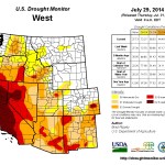

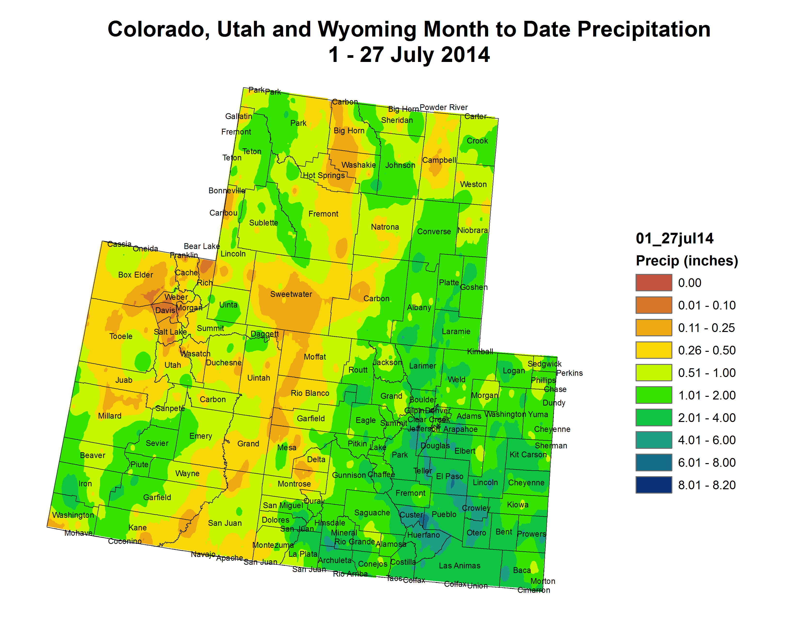


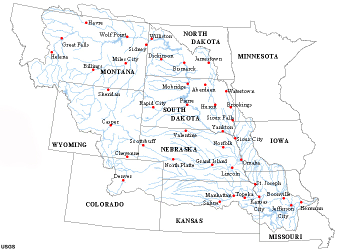


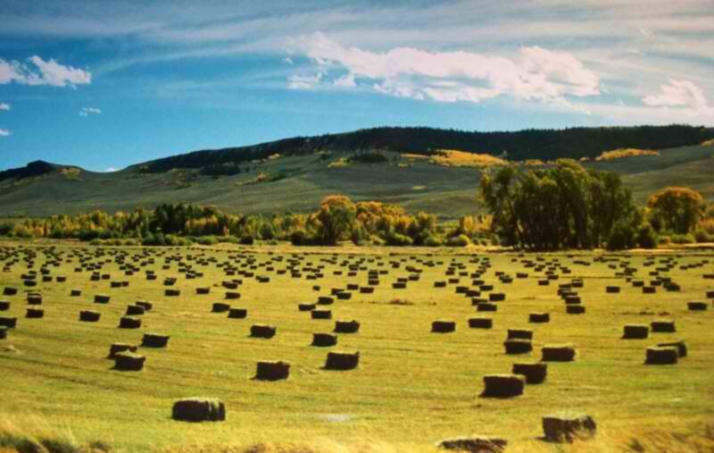

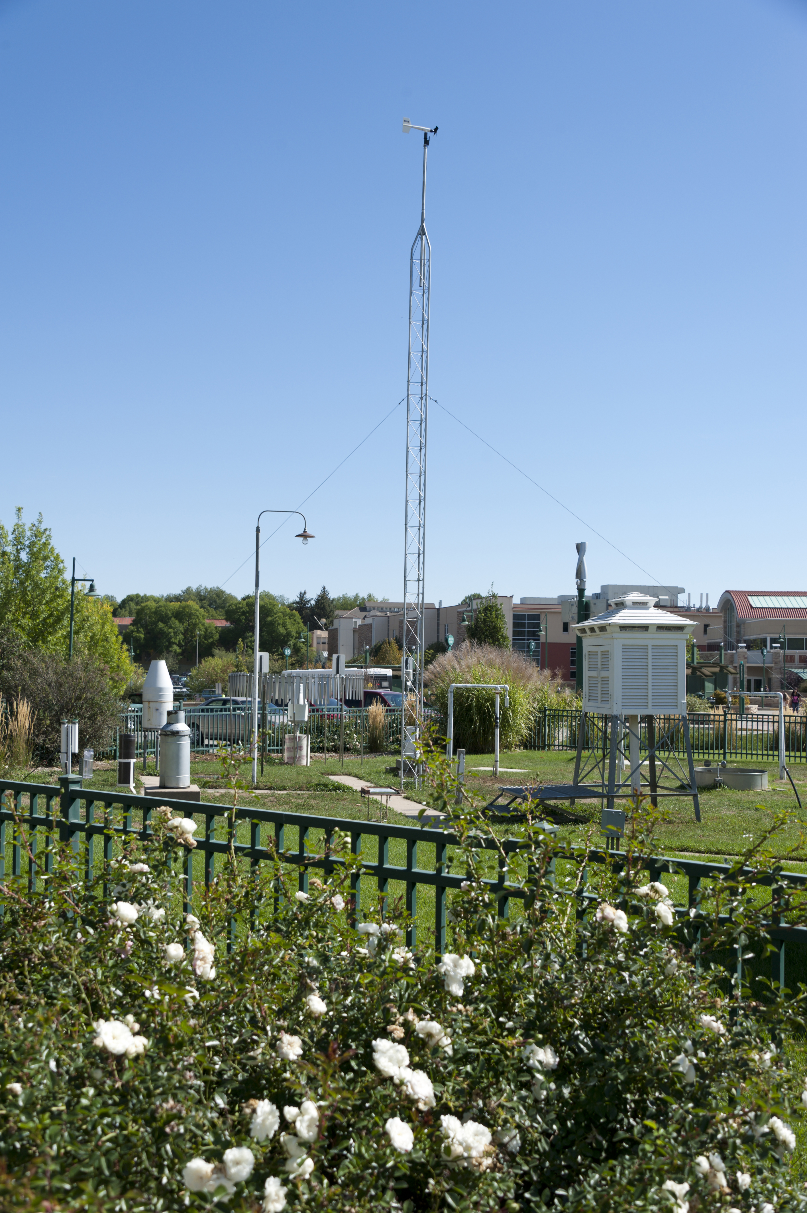


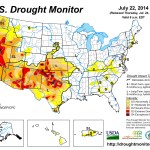

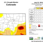
![Rio Grande and Pecos River basins. Map credit: By Kmusser - Own work, Elevation data from SRTM, drainage basin from GTOPO [1], U.S. stream from the National Atlas [2], all other features from Vector Map., CC BY-SA 3.0, https://commons.wikimedia.org/w/index.php?curid=11218868](https://i0.wp.com/coyotegulch.blog/wp-content/uploads/2013/04/pecosriverriograndewatershedswiki.jpg?w=292&h=345&ssl=1 "pecosriverriograndewatershedswiki")


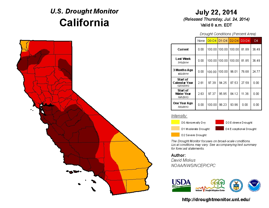
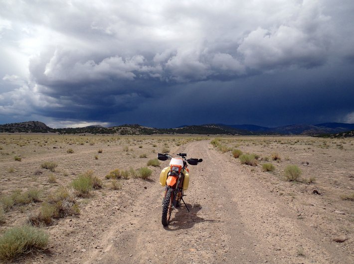


