
Click here to visit the US Drought Monitor website. Here’s an excerpt:
Summary
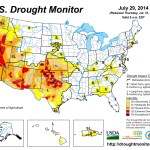
Spotty showers were heaviest in the East, where rain benefited pastures and summer crops. Meanwhile, mostly dry weather prevailed in the Midwest, except for a few bands of locally heavy showers. Despite a July drying trend, most Midwestern crops continued to thrive due to near- to below-normal temperatures and abundant soil moisture reserves. On July 27, USDA rated three-quarters of the U.S. corn and 71% of the soybeans in good to excellent condition—the highest such ratings this late in the season since 2004. Farther west, hot weather on the Plains yielded to sharply cooler conditions. In addition, rain overspread the central and southern High Plains late in the drought-monitoring period. The spell of hot weather hastened winter wheat maturation on the northern Plains and promoted rapid crop development throughout the nation’s mid-section. However, the Plains’ high temperatures also stressed some summer crops, especially in areas dependent upon rain or with lingering subsoil moisture deficits. Elsewhere, heat also arrived across the Southwest during a temporary break in the monsoon circulation, while cooler weather and beneficial showers overspread the Northwest. In particular, Northwestern showers aided containment efforts for a rash of lightning-sparked wildfires. However, the weather pattern reversed during the second half of the drought-monitoring period, with heat returning to the Northwest and a monsoon surge delivering heavy rain to parts of the Southwest…California
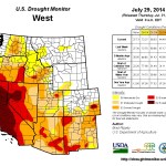
Increasingly, drought indicators point to the fact that conditions are not appreciably better in northern California than in central and southern sections of the state. In addition, mounting evidence from reservoir levels, river gauges, ground water observations, and socio-economic impacts warrant a further expansion of exceptional drought (D4) into northern California. For California’s 154 intrastate reservoirs, storage at the end of June stood at 60% of the historical average. Although this is not a record for this time of year—the standard remains 41% of average on June 30, 1977—storage has fallen to 17.3 million acre-feet. As a result, California is short more than one year’s worth of reservoir water, or 11.6 million acre-feet, for this time of year. The historical average warm-season drawdown of California’s 154 reservoirs totals 8.2 million acre-feet, but usage during the first 2 years of the drought, in 2012 and 2013, averaged 11.5 million acre-feet.Given the 3-year duration of the drought, California’s topsoil moisture (80% very short to short) and subsoil moisture (85%) reserves are nearly depleted. The state’s rangeland and pastures were rated 70% very poor to poor on July 27. USDA reported that “range and non-irrigated pasture conditions continued to deteriorate” and that “supplemental feeding of hay and nutrients continued as range quality declined.” In recent days, new wildfires have collectively charred several thousand acres of vegetation in northern and central California. The destructive Sand fire, north of Plymouth, California—now largely contained—burned more than 4,000 acres and consumed 66 structures, including 19 residences…
Northern Plains and Midwest
Patchy July dryness across the northern Plains and Midwest stood in stark contrast to near-record to record-setting June wetness. In one of the more dramatic examples, Sioux Falls, South Dakota, received rainfall totaling 0.80 inch (28% of normal) from July 1-29, following its wettest June and month on record (13.70 inches, or 349%). Due to antecedent wetness and persistently cool conditions, impacts from July dryness have been slow to emerge. However, pockets of abnormal dryness (D0) have begun to develop in a few areas of the western and southwestern Corn Belt. In addition to Sioux Falls, July 1-29 rainfall totaled less than an inch in locations such as Lincoln, Nebraska (0.51 inch); Mobridge, South Dakota (0.53 inch); Aberdeen, South Dakota (0.70 inch); Chesterfield, Missouri (0.70 inch); Valley, Nebraska (0.88 inch); Mason City, Iowa (0.90 inch); and Cahokia, Illinois (0.99 inch). By July 27, about one-sixth of the rangeland and pastures rated in very poor to poor condition Montana and Nebraska (16% in both states). On the same date, topsoil moisture ranged from one-quarter to one-half very short to short in several states across the northern Plains and Midwest, including Montana (48%), Nebraska (41%), Missouri (39%), South Dakota (29%), and Michigan (26%)…Northwest
Washington State’s largest wildfire on record, the quarter-million acre Carlton complex—sparked by lightning on July 14—was largely contained by month’s end. Still, the complex of four fires (Stokes, Gold Hikes, French Creek, and the Cougar Flat fires) was enormously destructive while burning through timber, grass, and brush, with more than 300 homes destroyed in the Okanogan County communities of Brewster and Pateros. Following a brief cool spell, intense heat returned across much of the Northwest late in the month. On July 29, daily-record highs in Washington included 107°F in La Crosse and 105°F in Wenatchee. Farther south, moderate to extreme drought (D1 to D3) crept northward in eastern Oregon. Meanwhile, widespread, out-of-season rainfall accompanied the brief cool spell in the Pacific Northwest, allowing for the elimination of abnormal dryness (D0) along the coast and some erosion of moderate drought (D1) in northwestern Oregon. From July 22-24, Oregon rainfall totals reached 1.04 inches in Portland and 0.98 inch in Astoria…Southern Plains
Cooler, showery weather late in the period helped to offset the effects of several hot days, resulting in only minor changes to the drought depiction. There were some improvements noted in a few areas, including Texas’ northern panhandle, where the coverage of extreme to exceptional drought (D3 to D4) was further reduced. A bit farther south, Lubbock, Texas, received 10.46 inches of rain (146 percent of normal) from May 1 – July 29, helping to dent the 30.47-inch precipitation deficit that accumulated from January 2011 – April 2014. Effects of the southern Plains’ long-term drought can still be observed in low lake levels and subsoil moisture shortages. On July 27, USDA reported that subsoil moisture was rated 65% very short to short in both Oklahoma and Texas. Rangeland and pastures have exhibited some recovery and are currently rated just 24% very poor to poor in Texas, along with 20% in Kansas and 19% in Oklahoma…Southwest
Robust monsoon rains, especially late in the monitoring period, chiseled away at long-term drought. Some of the greatest improvements in the drought depiction were noted across New Mexico and southern Arizona. Through July 29, month-to-date rainfall has totaled more than twice normal in several New Mexico locations, including Albuquerque (3.34 inches, or 242 percent of normal). Still, New Mexico’s rangeland and pastures were rated 65% very poor to poor on July 27, slightly worse than the late-July, 5-year average of 62%. In addition, New Mexico’s subsoil moisture was rated 67% very short to short. Similar conditions existed in other Southwestern States, with very short to short subsoil moisture ratings standing at 70% in Nevada, 68% in Utah, and 58% in Colorado. Meanwhile, Lake Mead—above Hoover Dam—which serves multiple states, recently fell to its lowest level since being filled during the 1930s…Looking Ahead
From July 31 – August 4, locally heavy showers will shift eastward across the South, eventually reaching the southern Atlantic States. Five-day rainfall totals could reach 1 to 3 inches from Florida into the southern mid-Atlantic region. Meanwhile, showers will linger across the central and southern Rockies in the wake of a significant rainfall event. Most of the remainder of the West will experience dry weather, except for isolated showers across the Great Basin and Intermountain region. Mostly dry weather will also prevail during the next several days from the northern Plains into the middle Mississippi Valley. Elsewhere, an ongoing heat wave in the Northwest will contrast with near- to below-normal temperatures in most other parts of the country.The NWS 6- to 10-day outlook for August 5 – 9 calls for the likelihood of below-normal temperatures in large sections of the central and eastern U.S., as well as the central Rockies, while hotter-than-normal conditions will cover the lower Southeast, the lower Rio Grande Valley, and the Far West. Meanwhile, near- to above-normal rainfall across the majority of the U.S. will contrast with the likelihood of drier-than-normal conditions in the Pacific Northwest, northern Plains, far upper Midwest, and southern parts of Arizona, Texas, and Florida.
From The Colorado Springs Gazette (Andrea Sinclair):
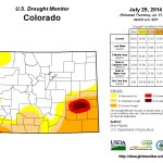
Recent monsoonal thunderstorms have soaked the Front Range with more rainfall than usual, but Colorado is not out of the dust bowl. Because droughts are fixed with snow, not rain.
According to the most recent report from the U.S. Drought Monitor, there has been some improvement in drought conditions across most of south-central and southeast Colorado.
“Currently, more than half of the state is free of drought while 40 percent is experiencing drought ranging from abnormally dry to exceptional,” the monitor’s July 2014 Drought Update said.
“The drought that is impacting southeastern Colorado is now well into its fourth year, but recent rains have brought some relief.”
Across the southeastern plains, the area in extreme drought decreased by 5.58 percent and the area in severe drought dropped by 1.75 percent from July 1 to July 25, the report showed. Only 0.92 percent of southeastern Colorado remained in exceptional drought, down from 1.89 percent at the start of the month…
And while the recent wet weather helps, Brian Bledsoe, chief meteorologist of Gazette news partner KKTV 11 News, said Wednesday that more is needed to alleviate the conditions brought on by four years of drought across southern Colorado.
“The damage that the drought has done over the past four years has been really widespread, and it has affected the soil’s ability to absorb moisture,” Bledsoe said. “I would equate it with pouring a glass of water over a kitchen table.”
Even if daily showers continue into next week, as predicted, National Weather Service meteorologist Eric Petersen said it will take more than one monsoon season to fully revitalize the state.
“For most of the summer a lot of the eastern plains have been a little wetter than normal, and this July several heavy thunderstorms over the plains have helped the drought areas,” Petersen said.
“We all need to be aware that while we’ve had a fairly wet pattern for the past couple of months, the drought takes shape through several years, and it will take much more than a couple of months of rain to take care of it,” he said…
Statewide reservoir storage is strong, with some providers reporting their best yields since 2001. The northern portion of the state is seeing higher storage levels than the southern half, according to the monitor report.
Exceptional drought conditions are now confined to southwestern and west-central Kiowa County, extreme northern Bent County, extreme southeastern Crowley County and extreme northeastern Otero County, the report said.
With the exception of extreme southeastern El Paso County, the rest of the Pikes Peak region was determined to be drought-free.