

Click here to go to the US Drought Monitor website. Here’s an excerpt:
Summary
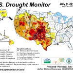
During the past 7-days, a series of weak upper-level disturbances and frontal systems at the surface brought widespread precipitation to much of the contiguous United States, outside of the Southwest and California. Heavy rain (2”-4”, locally greater) fell across portions of the Upper Mississippi Valley, the northern Plains, the Pacific Northwest, the west-central Gulf Coast region, the general vicinity of the southern Appalachians, and the Northeast. A low pressure area off the East Coast of Florida was in the process of developing into a tropical depression, and would become Tropical Storm Arthur by the end of the period.
Southern and Central Plains
Two to four inch rains fell over southern and central portions of Nebraska, prompting 1-category upgrades for these areas. In central and southern Kansas, 2-5 inch rains (locally heavier) warranted one-category improvements, especially in places which received two to three times their normal rainfall for the week. In Oklahoma, widespread one-category improvements were made in the northern portion of the state, due to very heavy rains during the past 30-days. For example, in the town of Buffalo, OK, 10.44 inches of rain fell during the past month, compared to the normal June rainfall of 4.08 inches. Flash flooding was also reported in Buffalo. On June 30th, the Oklahoma Panhandle experienced a very impressive dust storm. In the southeast portion of the state, minor degradations were rendered to the drought depiction. Texas had an unexpectedly wet week, with very heavy precipitation along the Gulf Coast (generally 3-5 inches, locally greater), and moderate to heavy precipitation (0.5-3.0 inches) in the interior East, supporting 1-category improvements. Relatively small alterations were made to the depiction in southern and far western Texas, both improvements and degradations.
Southwest and California
Little if any precipitation was observed in the Southwest during the past week. In western New Mexico, severe drought (D2) was downgraded to extreme drought (D3), and a general one-category degradation was rendered to the depiction in the southernmost counties of Luna, Dona Ana, and Otero. El Paso has received only 25 percent of its normal precipitation since January 1, 2014, making this the 7th driest year on record (so far) since 1879. High temperatures have been exacerbating drought-related impacts. Every day in June, El Paso was at or above normal, with a June departure of about +6.1 degrees F, making this the second warmest June on record, only behind June of 1994. In northeast Utah, most of the D2 area was downgraded to D3 conditions, while moderate rain (0.5-2.0 inches) supported a one-category improvement to parts of northeast Colorado. In southern Nevada, the continued lack of rain prompted the expansion of extreme drought (D3) conditions across parts of Nye, Lincoln, and Clark Counties, while in southern California, exceptional drought (D4) was expanded across Ventura, Los Angeles, and much of Orange Counties.
Looking Ahead
During July 3-7, 2014, most of the contiguous United States is expected to receive a half-inch or less of rain, though there are a few exceptions. Northern and central Florida, the Outer Banks of North Carolina, near the mid-Atlantic Coast, and the southern and eastern New England coasts may get 2-4 inches of rain, in part from what is currently Tropical Storm (projected to be hurricane) Arthur and from an active cold front approaching from the west. In the Middle Mississippi Valley, 0.5-1.0 inch of rain is forecast during this period, while 0.5-1.5 inches of rain is expected in association with the onset of the Southwest Monsoon across portions of Arizona, New Mexico and northern Texas. Temperatures during the period are anticipated to be mostly within 4 degrees of normal, though very brief departures of 8-10 degrees above normal are projected for the northern Plains region.For the ensuing 5-day period, July 8-12, 2014, there are enhanced odds of above-median rainfall in the east-central CONUS, the Great Lakes region, southern Florida, and the Southwest. Below-median precipitation is favored over the Pacific Northwest, the northern Rockies, and southwest Alaska. Mean temperatures for this period are favored to be above-normal over approximately the eastern and western thirds of the lower 48 states, and the southern half of Alaska, and near to below-normal temperatures are favored over the central third of the CONUS.
From The Pueblo Chieftain (Matt Hildner):
The U.S. Department of Agriculture has designated three San Luis Valley counties as drought-related natural disaster areas. The move, announced this week, makes farmers and ranchers in Conejos, Mineral and Rio Grande counties eligible for low-interest emergency loans.
While drought conditions have improved in the valley since last year, the three counties were eligible because they are contiguous to counties on the other side of the Continental Divide that have been declared primary disaster areas.
Farmers have until the beginning of March to apply for the loans from the Farm Service Agency.
The U.S. Drought Monitor currently lists the valley as abnormally dry, its least severe drought designation.
Last year, the valley was mired in severe drought, the third-most extreme of the monitor’s five designations.
Pueblo County and seven other Southeastern Colorado counties were given natural disaster designations in January.