East West Divide Apparent At Colorado Water Meeting #COWaterPlan

Colorado transmountain diversions via the State Engineer's office
Colorado transmountain diversions via the State Engineer’s office

From KUNC (Stephanie Paige Ogburn):

Water managers are taking the next steps in formulating a statewide water plan, following a meeting where representatives from Colorado’s eight water basins met and presented drafts of their individual plans.

There have been longstanding tensions between the state’s Western side and the Front Range over water transfers, and those differences came through in some of the presentations.

“We are already a major donor of water to the Front Range of Colorado,” said Jim Pokrandt, a representative from the Colorado River District, which manages water for six counties in that basin on the Western Slope.

Sean Cronin, executive director of the St. Vrain and Left Hand Water Conservancy District, represents the South Platte and Metro interests in the state water plan discussions. In his presentation, Cronin pointed out the Front Range will likely need additional sources of water from the Colorado River.

“The South Platte Basin is in favor of further development of Colorado’s [Colorado River] entitlement,” Cronin said.

The difference between Pokrandt’s western perspective and Cronin’s eastern one has been in existence for decades, say water experts…

The Western Slope’s Pokrandt said that while he appreciates existing conservation efforts from certain entities like Denver Water, Aurora, and Colorado Springs, the Front Range could do a lot more overall to use its water more efficiently.

“That’s going to include addressing your urban conservation, how we landscape, appliances and things that we have in our house. And Colorado hasn’t totally embraced that,” he said.

From the metropolitan side, Cronin said he saw the South Platte as a “model throughout the state” from a conservation standpoint.

“We agree, we feel there can be more done in the way of conservation. Where it starts to get controversial is to what degree.”

Cronin said the Metro/South Platte roundtable favored the preservation of local control over water, shying away from any measures that might force municipalities to use water in certain ways.

Another big focus for the South Platte is keeping water in agriculture, rather than doing what is called “buy and dry,” allowing farmland to go dry while the water is used in cities.

On the flip side, the desire to keep water in agriculture in the state’s eastern side is part of what drives the need for more transfers from the west, noted Pokrandt.

More Colorado Water Plan coverage here.

Steamboat Springs: 1st Yampa River cleanup day of season is Monday

Big Thompson Canyon: 1976 flood remembrance service set July 31 #BigThompson

bigthompsonflood073176
From the Loveland Reporter-Herald:

The 38th remembrance service for the flood of 1976 will take place at 7 p.m. Thursday, July 31 at the memorial site at the Volunteer Fire Department, 1461 W. U.S. 34, one mile below from Drake.

The service will feature music, three scholarship awards and a speaker who worked for search and rescue in the flood, who had to rescue himself and survive the most recent flood.

There will be a dedication of the bronze memorial, sculpted by George Walbye, which will be placed at the site in memory of Evelyn Starner and Patty Goodwine, who were killed in the September 2013 flood.

For details, call Barb at 667-6465.

Here’s an Allen Best column from The Denver Post that ran last fall after the flooding in the Front Range canyons:

The recent rainfall along the Front Range was phenomenal, by some estimates a 1,000-year event in terms of duration, volume and area. But the flooding?

Not so much, at least as measured by an obelisk along Boulder Creek in downtown Boulder.

Human memories about weather are unreliable. During many years living in Vail, how often did I hear that the latest powder storm was absolutely the best ever? Plenty. Flooding is like that, too, but maybe in reverse.

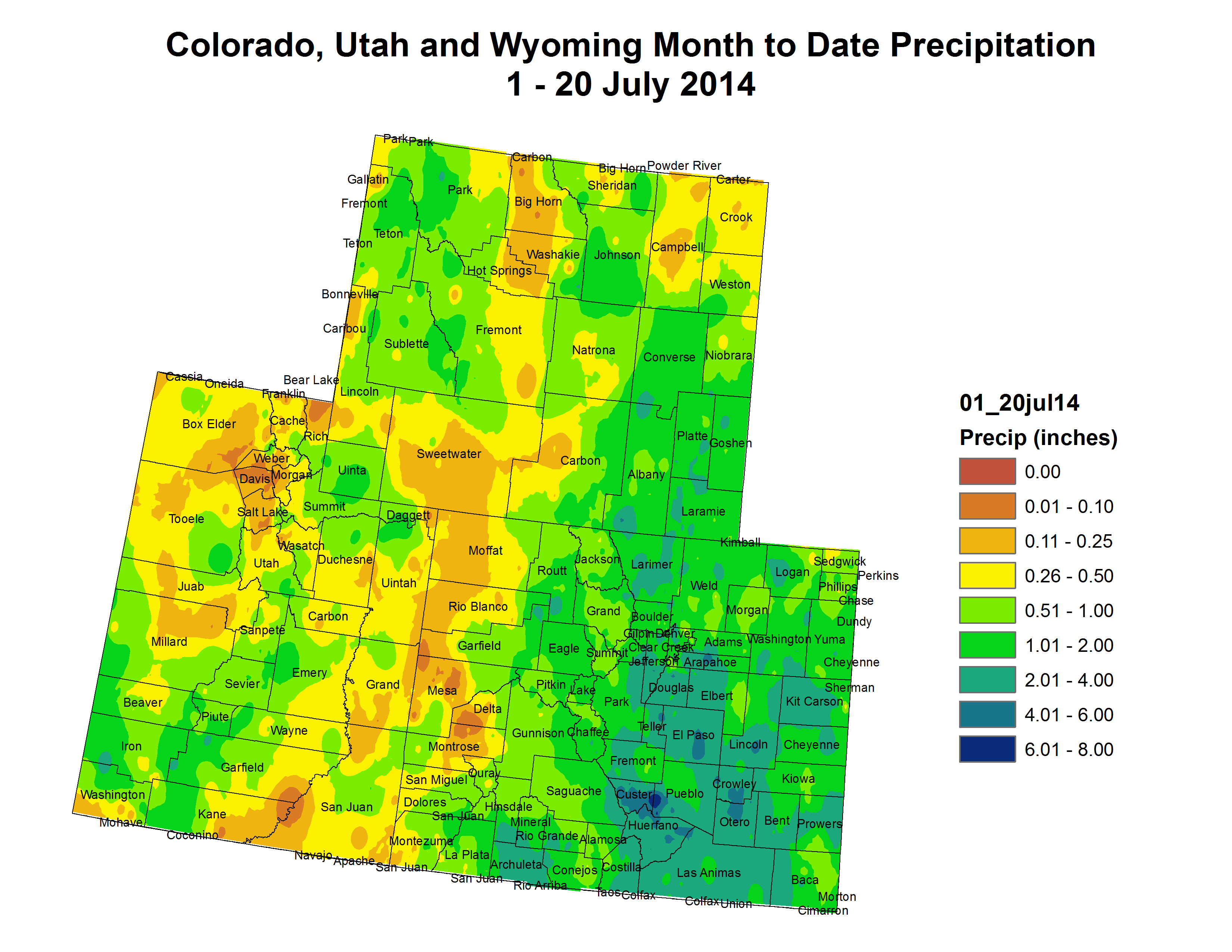
The turquoise obelisk in Boulder provides a better measure against long-term memory loss. Located near the Broadway bridge, it provides benchmarks for flood levels. The water this year lapped against the 50-year marker. Above it are others: 100 years, 500 years and, much higher yet, Big Thompson, a reference to the giant flood in that canyon between Loveland and Estes Park in 1976.

I was at the Big Thompson disaster. I was living in Fort Collins then and was among scores of young men (sorry, women, those were different times) with strong backs who could be summoned in case of forest fires. My only fire was at an old sawmill site in the foothills. The joke was that one of us had set the fire because we were so desperate for minimum-wage work.

Then came July 31. It was hot that night in Fort Collins. It hadn’t rained a drop.

I was living above Gene’s Tavern, just two blocks from the Larimer County Courthouse. When the call came, I was at the sheriff’s office almost immediately. It was 9 p.m.

Being among the first at the command center at the Dam Store west of Loveland, near the mouth of Big Thompson Canyon, I was assigned to a pickup dispatched to look for people in the water near the turnoff to Masonville. Already, the river was out of its banks. From the darkness emerged a figure, dripping and confused. “I went fishing at Horsetooth (Reservoir) and was driving home and then there was all this water,” he sputtered. He was befuddled. So were we.

Our leader decided we’d best get out of there. From what I saw the next morning, that was an excellent decision. Water later covered the road there, too. I spent the night at the Dam Store as the water rose. Helicopters were dispatched, but there was little that could be done. Our lights revealed picnic baskets, beach balls and propane bottles bobbing in the dark, roiling water that raced past us, but never any hands summoning help.

In the morning, we found those hands. The bodies were stripped of clothing and covered with mud. The first I saw was of a woman who we guessed was 18, not much younger than I was then. This thin margin between life and death was startling in my young eyes.

Eventually, 144 people were declared victims of the flooding that night (although one turned up alive in 2008 in Oklahoma).

Estes Park got some rain, but not all that much. The larger story was partway down the canyon, in the Glen Haven and Glen Comfort areas, where the thunderstorm hovered. In just a few hours, it dropped 10 to 14 inches of water.

Downstream in the canyon, just above the Narrows, some people were unaware that anything was amiss until they went outside their houses and saw the water rising in their yards. It hadn’t even rained there. One cabin I saw a few days later was stripped of doors and windows but stood on its foundations, a mound of mud 5 or 6 feet high in the interior. I seem to recall a dog barking as we approached, protecting that small part of the familiar in a world gone mad.

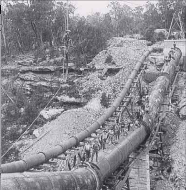
At the old hydroelectric plant where my family had once enjoyed Sunday picnics, the brick building had vanished. Only the turbines and concrete foundation remained. In a nearby tree, amid the branches maybe 10 or 15 feet off the ground, hung a lifeless body.

The river that night carried 32,000 cubic feet per second of water at the mouth of the canyon, near where I was stationed. It happened almost instantaneously — and then it was gone. It was a flash flood.

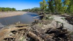
This year, the flows peaked at 10,000 cfs, but were more sustained and, according to reports, the damage inexplicably greater in portions of the canyon. There were horrors, too, but this year there was time for warnings.

After the 1976 flood, rain gauges were sprinkled in the foothills of the Front Range, up to 7,500 feet in elevation, where most heavy summer rains occur. That telemetrically transmitted information alerts police chiefs and sheriffs to flooding potential. That warning system may have saved lives this year.

Where does volume of this flood fit into the context of flooding in the last 150 years? That answer will have to wait. Many rain gauges were swept away, so peak flows will have to be calculated during field visits by U.S. Geological Survey personnel. That will take several weeks.

One more banner of comparison was 1965, when rivers and creeks from Castle Rock to Lamar to Fort Morgan flooded.

The flood that swept through Littleton and Denver created a mess, but led to the rethinking of the South Platte River as an asset rather than industrial afterthought.

East of Denver and Colorado Springs, the same storms transformed Bijou Creek from a lifeless expanse of sand into an angry, snarling mass of water. At Fort Morgan, after entering the South Platte River, it nearly submerged the arches of the Rainbow Bridge. This year’s flooding, according to several eyewitness accounts, didn’t even come close.

We’ve had other floods, too. Even in the midst of the Dust Bowl, there were giant floods in eastern Colorado, both on the South Platte and in the Republican River.

My guess is that this flood will be the most damaging ever in Colorado history. Part of this is due to how broad the inundation was, from Colorado Springs to Wyoming. Population growth is also part of the story. Colorado now has 5.2 million people, almost double that of 1970, most of us crowded between Castle Rock and Wellington, a good many in the foothills, those areas so vulnerable to fires but also flooding.

This flood once again points to the importance of land-use planning. Where you put sewer plants does matter. You can’t anticipate every natural disaster, but floods have an element of predictability.

Boulder has had big floods before, most notably in 1894. It also had the direct lesson of Big Thompson and the local influence of Gilbert White, who died in 2006. “Floods are ‘acts of God,’ but flood losses are largely acts of man,” he had said. Boulder has muddy feet, but the consequences would have been much worse had the city not taken his advice and removed structures from along the creek to the west and resized bridges to accommodate more water. The obelisk is in his honor.

John Pitlick, a hydrologist at the University of Colorado, says the flood this year peaked at about the 50-year marker on the obelisk.

In one of his classes, he also noted that rainfall and flooding aren’t one and the same. “It is possible from a statistical analysis to be a 1,000-year rain, but you don’t necessarily have a 1,000-year flood.”

In other words, context matters entirely. Had the water fallen in a shorter time, such as it did in the Big Thompson in 1976, Boulder’s story almost assuredly would have been different. “We might have seen a catastrophe,” he says.

That leaves us in something of a no-man’s land, as Pitlick puts it.

This year’s floods were a big deal but, aside from individual losses, not catastrophic to Colorado. What lessons do you draw for future flood planning? That’s the question for communities along the Front Range in months ahead.

More Big Thompson River watershed coverage here.

Weekly Climate, Water and Drought Assessment of the Upper #ColoradoRiver Basin

Upper Colorado River Basin month to date precipitation July 1 thru July 20, 2014

Click here to read the current assessment from NIDIS (hosted by the Colorado Climate Center).

Greeley gets USACE permit for pipeline

pipeline

From the Fort Collins Coloradoan (Kevin Duggan):

After a 7-year process and multiple studies, the U.S. Army Corps of Engineers has issued a permit that would allow Greeley to build a 6-mile section of pipeline known as the Northern Segment.

The city plans to run the pipeline under the Poudre River and through open fields on private property south of the river.

Greeley officials plan to work with affected property owners during the coming months to get easements for the pipeline, said Eric Reckentine, deputy director of water resources for Greeley Water and Sewer.

Construction is expected to begin in late fall and last about a year and a half. The segment is expected to cost about $25 million.

But the fight over the pipeline is not over and could end up in court.

Rose Brinks, who lives off Overland Trail near the river and Lions Park, stated in an email to the Coloradoan that she will not allow her family’s historic farm to be “torn up for such a pipeline.”

Greeley could use eminent domain to get the rights of way it needs to build the project.

“We would prefer to negotiate with property owners,” Reckentine said.

Brinks and other affected property owners have contended for years that the project should be built along another route, such as under Larimer County Road 54G.

But Greeley officials say their preferred route would disrupt fewer properties and would not require the removal of homes. It also would not force monthslong construction closures on LaPorte’s main street.

As part of the process of getting the permit, Greeley had to do extensive studies on the environmental impact of the project and its potential effects on historic sites, such as a section of the old Greeley, Salt Lake and Pacific Railroad line on Brinks’ property.

Greeley plans to bore underground to get the pipeline through sensitive areas, Reckentine said…

The 30-mile pipeline project would run from Greeley’s water treatment plant near Bellvue to Gold Hill Reservoir west of the city. Two-thirds of the pipeline is complete and operating. The segment that runs through Fort Collins ends at Shields Street.

From The Greeley Tribune (Sherrie Peif):

After seven years of fights and headaches, Greeley officials can finally celebrate. The Army Corps of Engineers gave approval for the final 6-mile segment of the Bellvue Pipeline from the Fort Collins/LaPorte/Bellvue area.

The final addition, which runs from Shields Street in Fort Collins to the Bellvue Treatment Plant at the mouth of the Poudre Canyon, will complete the $80 million, 30-mile pipeline. It will have the capacity to deliver an additional 50 million gallons of water per day to Greeley, enough to satisfy the projected need of Greeley’s water customers for the next 50 years.

The city hit roadblocks every direction it turned with landowners worried about the impact on wildlife and historical structures, as well as noise and fumes and the other effects of construction.

Then, concern over the Preble jumping mouse habitat got in the way. Greeley was required to study the mouse habitat and any impacts under the State and National Historic Preservation Acts before the permit verification was issued.

There are still four property owners trying to hold up the process, said Eric Reckentine, deputy director of water resources for Greeley, but the city has the go-ahead for construction, which is expected to begin in the fall.

It will run under the originally proposed 28 different properties. The city could take any remaining land through eminent domain laws if it needs to.

“We’re still working through some issues with those landowners,” Reckentine said.

He did not know how much the city has spent in legal fees on the project.

Officials say the route is the least destructive. An alternative would have traveled under Main Street in LaPorte and under that town’s two schools. When completed, this will be only the second extension of water pipeline the city has done in 100 years.

The city, which since the 1950s has had two existing 27-inch pipelines through the town, has two-thirds of the 60-inch line built and some portions already in operation.

The line parallels about 65 percent of the city’s existing lines, but it will move through a portion of historically registered property along Overland Trail at the southern edge of LaPorte. Retired water director Jon Monson said in 2011 that the structures would be completely avoided by tunneling beneath them, roughly 18-20 feet for about 1,700 feet.

The city still needs some additional permits to increase the water capacity, but Reckentine said he was confident they would not be a problem.

“This is an important project for Greeley,” Reckentine said. “We are just glad we can begin construction.”

More infrastructure coverage here.

EPA: Our proposal to protect clean water won’t affect state water laws, including those on water supply and use

Fountain Creek: “It seems to me at some point there will be a balance between water rights and property rights” — Steve Witte

Fountain Creek flood debris May 2014 via The Pueblo Chieftain

From The Pueblo Chieftain (Chris Woodka):

Would a dam on Fountain Creek make a difference in a situation such as last week’s drainage along the Arkansas River?

“It is something we need to talk about,” Water Division 2 Engineer Steve Witte said Monday, looking back at a wild ride of a week on the river. “It’s a discussion that needs to take place. It seems to me at some point there will be a balance between water rights and property rights.”

The Arkansas Basin Roundtable earlier this month turned away a grant request from the Fountain Creek Flood Control and Greenway District to study the practical effects of building a dam or system of detention ponds on Fountain Creek.

Chief among objections: the damage to junior water rights. By changing the peak flow on Fountain Creek floods — delaying the time it takes water to reach points downstream — junior water rights might not come into priority.

On the other hand, the peak flows that came crashing off the prairie into already full canals caused three of them to blow out after storms early last week.

“We already have an example, Pueblo Dam, of how we can reduce flood damage,” Witte said. “On the South Platte, they already are using upstream, out-of-priority storage. They use the water where it exists and determines who gets it later.”

Answering the basic question of whether those types of programs might work on Fountain Creek — the largest single tributary to the Arkansas River in Colorado — needs to be explored. Otherwise the only option to catch floodwater below Lake Pueblo is John Martin Reservoir, Witte said.

“I hope they’ll come back with a revised request,” he said.

One of the problems with last week’s storms is that much of the water was flowing in from unmeasured creeks and gullies. There are no gauges on Chico Creek or Kramer Creek, both a few miles east of Pueblo. Chico Creek boosts flows past the Avondale gauge, but no one can be sure just how much is being contributed to the river. The break in the Colorado Canal was caused by heavy flows on Kramer Creek near Nepesta.

“We were just flying blind,” said Witte, who witnessed the flooding at Nepesta.

The water from several tributaries hit the Arkansas River at the same time, creating “waves” that peaked quickly and then subsided. Some falsely high readings caused unnecessary worries downstream, where no major flooding occurred.

While the system of satellite river gauges has grown in the past 25 years, and provide easy access to information on the Internet, some malfunctioned during last week’s storms. Division of Water Resources staff scrambled to find out what was happening.

“I think we’ve improved, but there is still an element of human judgment,” Witte said. “We need to have people on the ground to verify if our gauges are accurate.”

More Fountain Creek coverage here and here.

Snowmass: Colorado Water Congress summer meeting “Rallying Our Water Community” August 20-22

Westin Snowmass Resort

From email from the Colorado Water Congress (Doug Kemper):

Excitement continues to build for our 2014 Summer Conference and Membership Meeting. It will be held at the Westin Snowmass Resort, August 20-22. Our theme this year is “Rallying Our Water Community.” To register please visit: Conference Registration.

We will know in a couple of weeks if enough signatures have been gathered to place Initiative 89, Local Government Regulation of the Environment, on the 2014 Ballot. Whether it does or not, the water community will need to develop a greater public presence on these issues. Our conference is designed to help develop your advocacy skills and knowledge base.

We want to ensure we are focused on our member’s priorities when the Water Congress Board sets our priorities this fall. Summer Conference activities are designed to give you the opportunity to provide direct input to our leadership. We hope that you will take this chance to engage with us.

Our exciting program will again include a session with the Water Resources Review Committee. Additional honored guests include both Republican and Democratic candidates for the U.S. Senate, U.S. House Third District, and Attorney General. Don’t miss this chance to catch up with colleagues and meet new community members during our POND networking activities.

Highlights of our unique program sessions include:

Strategies for Finding Your Voice
Do you have adequate tools to advocate on behalf of Colorado’s water community? Practice conveying your message with other attendees and workshop leaders.

Senator Udall, Congressman Gardner, Congressman Tipton, and Former State Senator Tapia
We are pleased to host candidates for some of our top political offices as they address issues of keen importance to Colorado’s water community.

Costs of Doing the Right Thing
As we plan for our water allocation in the future, we rarely examine the full social and economic costs, including burdens on individual ratepayers. This panel will examine those costs, along with a brief overview of other economic challenges currently faced by Colorado water providers.

Mono Lake
For 100 years, the L.A. Aqueduct has been the source of legend and controversy. Today, drought imperils much of California’s water supply. How is Los Angeles handling the drought within the confines of a Public Trust Doctrine?

Mitigation for Transbasin Diversion
Past Aspinall Water Leaders will discuss historic transbasin water projects and their mitigation. What can we learn from the past?

We are looking forward to seeing you in Snowmass, August 20-22. Additional conference information and registration can be found at: Conference Information.

More education coverage here.

Big Thompson River restoration meeting set July 31 — Loveland Reporter-Herald

Flood damage Big Thompson Canyon September 2013 -- photo via Northern Water
Flood damage Big Thompson Canyon September 2013 — photo via Northern Water

From the Loveland Reporter-Herald:

A Big Thompson River master planning meeting will be held at 6-8 p.m. Thursday, July 31, at the Thompson School District Administration Building, 800 S. Taft Ave.

The third in a series of meetings held to look at options for river restoration after last September’s flood, the session will present preliminary recommendations for restoration of the river and design plans.

Stakeholders will get the chance to offer feedback.

For details, call 420-7346 or visit http://bigthompsonriver.org.

The Arkansas Valley Super Ditch files pilot rotational fallowing application with the CWCB

Arkansas River Basin — Graphic via the Colorado Geological Survey

From The Pueblo Chieftain (Chris Woodka):

The Arkansas Valley Super Ditch is planning a pilot program next year under a 2013 state law encouraging water sharing programs as an alternative to permanent dry-up of farm ground. The plan, filed with the Colorado Water Conservation Board last week, would lease up to 500 acre-feet (163 million gallons) annually from the Catlin Canal to Fowler, Fountain and Security. About 1,128 acres would be dried up on a rotational basis to deliver the water.

“What we’re trying to do is see if a lease-fallowing program is viable,” said Jay Winner, general manager of the Lower Arkansas Valley Water Conservancy District. “We’re trying to keep the water in the Arkansas basin. That’s what it’s all about.”

The application is the first to be filed under HB1248, passed last year by the state Legislature, which allows the CWCB to look at 10 test projects throughout the state. The projects are supervised by the state water board, with input from the state engineer. It may finally launch Super Ditch pilot projects that have stalled because of drought and second thoughts by farmers.

The Super Ditch submitted a substitute water supply plan with the state Division of Water Resources in 2012 for a lease-fallowing pilot project with Fountain and Security that failed because there was not enough water to move. The state restrictions that were placed on the project, fueled by objections from other water users, made moving any water in that dry year futile, Winner explained.

Last year, the Super Ditch was prepared to move some High Line Canal water to Fowler, but the deal was stopped when farmers pulled out. Fowler leased 125 acre-feet of water for $25,000 from the Pueblo Board of Water Works instead.

Under the plan outlined in the application, Fowler would lease up to 250 acre-feet, while Fountain and Security would lease up to 125 acre-feet each annually.

State law provides that the plan can be operated for 10 years.

“I think we’ll try it for a year or two, just to see if lease-fallowing is feasible,” Winner said. “We have to see if we can move water to Lake Pueblo. One of the drawbacks of HB1248 is that it only allows for municipal leasing, but if this works, there’s the possibility for industrial or agricultural leases as well.”

More Arkansas Valley Super Ditch coverage here and here.