From email from the Colorado Water Conservation Board (Ben Wade):
The next Water Availability Task Force meeting will be held on Wednesday, July 23, 2014 from 9:30a-11:00a at the Colorado Parks & Wildlife Headquarters, 6060 Broadway, Denver in the Bighorn Room.
Click here to go to the Climate Prediction Center to read the discussion. Here’s an excerpt:
Synopsis: The chance of El Niño is about 70% during the Northern Hemisphere summer and is close to 80% during the fall and early winter.
During June 2014, above-average sea surface temperatures (SST) were most prominent in the eastern equatorial Pacific, with weakening evident near the International Date Line. This weakening was reflected in a decrease to +0.3°C in the Niño-4 index. The Niño-3.4 index remained around +0.5°C throughout the month, while the easternmost Niño-3 and Niño-1+2 indices are +1.0°C or greater. Subsurface heat content anomalies (averaged between 180º-100ºW) have decreased substantially since late March 2014 and are now near average. However, above-average subsurface temperatures remain prevalent near the surface (down to 100m depth) in the eastern half of the Pacific. The upper-level and low-level winds over the tropical Pacific remained near average, except for low-level westerly anomalies over the eastern Pacific. Convection was enhanced near and just west of the Date Line and over portions of Indonesia. Still, the lack of a clear and consistent atmospheric response to the positive SSTs indicates ENSO-neutral.
Over the last month, no significant change was evident in the model forecasts of ENSO, with the majority of models indicating El Niño onset within June-August and continuing into early 2015. The chance of a strong El Niño is not favored in any of the ensemble averages for Niño-3.4. At this time, the forecasters anticipate El Niño will peak at weak-to-moderate strength during the late fall and early winter (3-month values of the Niño-3.4 index between 0.5°C and 1.4°C). The chance of El Niño is about 70% during the Northern Hemisphere summer and is close to 80% during the fall and early winter.
Forecasters at the Climate Prediction Center haven’t declared El Niño conditions, even though the Niño3.4 index is currently around 0.5°C above normal, and has been for the past two months. What’s the hold up? In short, we’re waiting for the atmosphere to respond to the warmer sea-surface temperatures, and give us the “SO” part of ENSO.
SO what? The Southern Oscillation, that’s what. The Southern Oscillation is a seesaw in surface pressure between a large area surrounding Indonesia and another in the central-to-eastern tropical Pacific; it’s the atmospheric half of El Niño. Since ENSO is a coupled system, meaning the atmosphere and ocean influence each other, both need to meet the criteria for El Niño before we declare an El Niño event.
During average (non-El Niño) times, the waters of the western tropical Pacific are much warmer than in the east/central area (Figure 1). As warmer water extends out to the east during an El Niño, it warms the air, causing it to rise (lower pressure) (Figure 2). In turn, there is less rising motion (higher pressure) near Indonesia, due to the relatively cooler waters and overlying air…
The pressure changes influence the wind patterns. The average (non-El Niño) state of the atmosphere over the tropical Pacific features convection and rainfall over Indonesia, low-level easterly winds (the trade winds that blow from east to west), and upper-level westerly winds (Figure 1). These are the basic components of the Pacific Walker Circulation.
During El Niño, the system shifts: we see weaker trade winds over the Pacific, less rain than usual over Indonesia, and more rain than usual over the central or eastern Pacific. During some El Niño events, the trade winds along the equator even reverse, and we see low-level westerlies… but not every time. In fact, every El Niño is different, and both the ocean and atmospheric characteristics vary quite a lot from event to event–but that’s a topic for another post!
This difference from average air pressure patterns across the Pacific is measured a few different ways. One is the Southern Oscillation Index (SOI), which is based on a long record of pressure measured by two stations: one in Darwin, Australia (south of Indonesia) and the other in Tahiti (east-central tropical Pacific) (Figure 3). A negative SOI indicates Darwin’s pressure is higher than average and Tahiti’s is lower than average: El Niño conditions. (I keep saying “higher than average” because we’re not just comparing Darwin’s pressure to Tahiti’s, but rather comparing the anomalies at each. Imagine comparing the price of a gallon of water to that of a gallon of gas. A negative index is if the price of the water goes up, and the gas goes on sale. The gas may still cost more than the water, but it’s the relative changes in the two prices that matter.)
A second way we describe the air pressure anomalies over the tropical Pacific is the Equatorial Southern Oscillation Index (EQSOI). The EQSOI is based on pressure differences between two regions located on the equator (Figure 3). The SOI is monitored because it has a very long record available, stretching back to the 19th century; the EQSOI depends on satellite observations, which means it is a shorter record, but it gives a better picture of what’s happening right along the equator…
As of the end of June, both the SOI and the EQSOI are at +0.2 (they have trended downward over the past few months), and the wind patterns are roughly average over the tropical Pacific, with some slight weakening of the trade winds toward the end of the month. There is increased convection in the central Pacific, but also some over Indonesia… all of which says we’re still waiting for the atmosphere to get dressed in its El Niño clothes and come out to play.
However, we think it’s likely that the atmosphere will get on board soon, and we’re still predicting El Niño, with about a 70% chance that conditions will be met in the next few months, and around an 80% chance by this fall. If you’re interested in how the ocean and atmospheric conditions are evolving, CPC has weekly updates available.
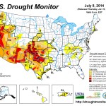
Click here to go to the US Drought Monitor website. Here’s an excerpt:
Summary
During the past 7-days, heavy rain (greater than 2 inches) fell in parts of the Northeast, eastern North Carolina, the Florida peninsula, the Great Lakes region, northern and central portions of the Mississippi Valley, and parts of the southern Great Plains and Southwest. An unusually strong cold front for early July moved across the eastern contiguous U.S. early in the period, approaching the Atlantic Seaboard as a Category-2 hurricane (Arthur) was moving across the Outer Banks of North Carolina. As the hurricane accelerated to the northeast, it gradually became incorporated into the larger-scale cold front and associated low pressure system, resulting in heavy rains across portions of the Northeast. Meanwhile, the onset of the Southwest summer monsoon across Arizona and New Mexico brought moderate precipitation (0.5-2.0 inches) to portions of the Four Corners region…
Southern and Central Plains
A relatively narrow band of heavy rain (greater than 2 inches) was observed from near Lubbock to Wichita Falls in Texas, while a fairly concentrated area of heavy rain was reported from about Houston to Victoria in eastern Texas. About a dozen relatively minor revisions were made to the depiction in Texas this week, some degradations and some improvements. No changes were made in Oklahoma, Kansas, or Nebraska this week, in part due to widespread areas of well above-normal precipitation in the past 30-days (3-6 inches, locally greater, especially in Kansas and Nebraska). Another reason for not making alterations this week is to better assess the impacts from recent precipitation, and to consider areas ripe for downgrades next week. In eastern South Dakota, no changes were rendered this week either to the drought depiction. However, the coverage of abnormal dryness in this area will need to be revisited next week, along with the possibility of introducing some moderate drought (D1). In Wessington Springs, corn still looks okay, but surface water is lacking and grasses are drier…
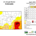
Southwest and California
The initial moisture surges of the summer monsoon commenced on schedule across Arizona and New Mexico this past week. River Forecast Center rain gauge data depicts a few widely scattered 2-3 inch rainfall amounts, but much of Arizona and New Mexico reported moderate amounts of precipitation (0.5-2.0 inches). In northwest New Mexico, which missed out on the significant rainfall this past week, extreme drought (D3) was expanded eastward across all of San Juan County, and continuing across the western one-third of Rio Arriba County. In south-central Colorado, a one-category downgrade was made, based on very dry short-term SPI’s (less than -1.5), and on VIC soil moisture model considerations. In southeast Colorado (western Kiowa County), conditions are still deplorable with little vegetation on the ground, and there is also the occasional dust storm kicking up. In Otero County, where better moisture conditions exist, a one-category improvement was made to the depiction. In Baca County, a one-category improvement was rendered based on June-early July precipitation, SPI values near and slightly above zero, and reports that the wheat harvest is looking better than it has in this county for several years. No other modifications were made throughout the Southwest or California. As an important side note, according to the Federal Bureau of Reclamation, southern Nevada’s Lake Mead is expected to fall this week to its lowest level since 1937, when the manmade lake (the largest reservoir in the United States) was first being filled…
The Pacific Northwest
No alterations were made to the depiction this week. In southwest Idaho, the flow of the Owyhee and Bruneau Rivers is near record lows for the second consecutive summer, while record low Water-Year-To-Date (WYTD) precipitation has fallen at various SNOTEL sites in central Idaho…
Looking Ahead
During July 10-14, 2014, a broad band of moderate precipitation (0.5-2.0 inches) is expected from Arizona and New Mexico northeastward and eastward across the north-central Plains, the north-central Mississippi Valley, the Ohio Valley, and interior Northeast. A band of moderate to heavy rainfall (1.0-3.5 inches) is forecast for the central and eastern Gulf Coast states, and the southern Atlantic states from Florida to Delaware.
For the ensuing 5-day period, July 15-19, 2014, there are enhanced odds of above-median rainfall in the Southwest, the Southeast, and over northern and southwestern Alaska. There are enhanced odds of below-median rainfall in the Pacific Northwest, from eastern Montana to Michigan, southern Texas, southern Louisiana, and over south-central and southeast Alaska including the Panhandle.
Colorado transmountain diversions via the State Engineer’s office From the Glenwood Springs Post Independent (John Stroud):
Though Colorado River Basin water users strongly urge against any new trans-mountain diversions to the East Slope as part of a draft plan for the basin released last week, a key part of the process to create a state water plan recognizes a need to eventually have that discussion. In addition to further refining the basin plan itself, the Colorado Basin Roundtable has been reviewing a conceptual inter-basin agreement that outlines parameters for negotiating new diversion projects.
“We do take the position that another big trans-mountain diversion would have a major impact on the Western Slope,” said Jim Pokrandt, chairman of the Colorado Basin Roundtable.
Skepticism about new diversions is shared by other Western Slope basin roundtables, he said. But the Colorado basin in particular has placed a strong emphasis on setting the bar high for water conservation and exhausting other resources within the eastern basins before new diversion projects are considered.
Last month, the Inter-basin Compact Committee, which includes representation from each of the state’s nine basin roundtables, finalized a draft conceptual agreement to submit to the Colorado Water Conservation Board for inclusion in the draft state water plan, due out by the end of this year.
Basin implementation plans from each of the roundtables are being submitted this month, all of which will go to create the comprehensive Colorado Water Plan that Gov. John Hickenlooper has requested be done by the end of 2015.
East Slope water interests have been adamant that, in addition to water conservation measures, protecting agriculture and looking at more water storage within basins east of the Continental Divide, the state plan must keep open the possibility of diverting more water from the Western Slope.
The draft agreement outlines seven “points of light,” as Pokrandt referred to them, that would have to be addressed collaboratively and agreed upon before a new diversion project could be OK’d. Those include concessions by eastern Colorado water users that they not seek a specific yield from a new trans-mountain diversion (TMD), and would accept hydrologic risk for any new projects.
Also, any new TMD project would have to come with an agreement that it be in conjunction with existing eastern basin supply agreements, aquifer resources, reuse and other non-West Slope water sources, and that specific triggers be set for when diversions can occur.
Future West Slope water needs, including for recreation and environmental protections, would have to be spelled out in the agreement.
“There are lots of questions about hydrology, environmental concerns and compact considerations that would need to be addressed,” Pokrandt said. “Nevertheless, this is a way to talk about a project among the different groups and all the questions that have to be answered.”
The state faces legal concerns to make sure compacts are fulfilled regarding how much water makes its way from the upper Colorado Basin to downstream users in other states, he emphasized.
Each of the roundtable groups is scheduled to give a presentation on its basin implementation plan at a Colorado Water Conservation Board meeting in Rangely on July 16.
Even after the draft basin plans are submitted, they are likely to be undergo further revisions as the process continues to draft the state plan, Pokrandt said.
“Compared to where we were four months ago, we have made a lot of progress,” he said of the Colorado Basin plan, which was prepared by engineering consultants with SGM in Glenwood Springs.
Gov. John Hickenlooper, during an interview with the Post Independent last week, said one of the main goals in asking for a state water plan was to get East Slope and West Slope interests talking.
“The most important thing that can come out of this is to establish relationships, and to get to know each other … and each other’s habits and behaviors,” the governor said.
In any case, conservation will be a key emphasis, Hickenlooper said.
“What we’ve always said is that any conversation in the state about water has to start with conservation,” he said. “We will have to work out some compromises, and there will be some ruckus, but we will work it out.”
The Colorado Basin Roundtable meets again from noon to 4 p.m. July 28 at the Glenwood Springs Community Center to further discuss and refine the basin implementation plan.
Also, the interim Water Resources Committee of the Colorado General Assembly is coming to Glenwood Springs on Aug. 21 to take testimony from citizens on the Colorado Water Plan process.
That meeting will take place from 5 to 7 p.m. at the Glenwood Springs Branch Library at 8th and Cooper.
Meanwhile, the South Platte and Metro Roundtables are ready to submit their basin implementation plan. Here’s a report from Eric Brown writing for The Greeley Tribune:
After years of discussion, the river basin that faces the “biggest challenges” is nearing completion of its first draft of a long-term water plan. That outline of how agriculture, cities and industries will coexist in the future — while minimizing expected water shortages — will be available to the public next week.
Sean Cronin, chairman of the South Platte Basin Roundtable, a group of water officials and experts who meet regularly to address water issues in northeast Colorado, said the combined draft plan from the South Platte and Metro roundtables is expected to be approved at a meeting Monday.
After that, it will go to the Colorado Water Conservation Board, which will begin piecing it together with the implementation plans of the seven other roundtables in the state, to create the comprehensive Colorado Water Plan that Gov. John Hickenlooper has requested be done by the end of 2015.
It’s been a long time coming, according to South Platte and Metro roundtable members, some of whom met Tuesday to finalize the language in its draft plan. The basin roundtables across Colorado have been meeting since 2005.
In the draft that will be completed soon are the major points northeast Colorado water officials and users have been driving home during the past nine years — protecting agriculture, water conservation, more water storage and keeping open the possibility of diverting more water from the West Slope, among other key points.
While the group has reached consensus on those issues, there remains some dispute on others, such as how groundwater management might be addressed in the plan, and how municipal land use — which has impacts on water functions — might factor in.
That’s why the South Platte and Metro roundtables want public input once the draft plan is available next week, possibly as early as Monday evening.
All basin implementation plans are due by July 16. The South Platte and Metro roundtables pushed the deadline, likely because of the complexity and unique challenges in the basin — perhaps the biggest “challenges in the state,” roundtable members say.
The South Platte Basin includes six of the state’s 10 top ag-producing counties, including Weld County, which ranks ninth in the nation for its value of production. Three of the other top 10 are also in northeast Colorado in the nearby Republican River Basin, which is impacted by South Platte basin functions.
Also, eight of the 10 largest cities in Colorado are in the South Platte basin, including Denver and Aurora (which is why the South Platte and Metro roundtables are combining their implementation plans).
Because of that and continued growth, the South Platte basin, which stretches across northeast Colorado from southwest of Denver to the Nebraska stateline, faces the biggest expected water shortages in the state. According to projections, there will be a municipal and industrial water-supply gap of as many as 190,000 acre feet (about 60 billion gallons) annually by 2050, with as many as 267,000 acres of irrigated farmground dried up by then.
How will it all fit together?
In addition to the challenges within the basin, members of the South Platte and Metro roundtables are concerned about how their plan will mesh with others and are worried that in trying to make all eight plans come together, some of the South Platte’s priorities could get lost.
“With each basin having its own interests and each facing its respective challenges, it’s going to be a Herculean effort … to bring all of these together without something getting lost,” said Eric Wilkinson, general manager of the Northern Colorado Water Conservancy District in Berthoud, which oversees the largest water-delivery system in northern Colorado and is working to put in place more water-storage projects. “Each basin has put in a lot of time and thought into their plans, and to see something get lost along the way going forward would be tough for any of us.”
South Platte Basin water officials have been particularly concerned all along that, because of its controversial nature, talks of bringing more West Slope water across the Continental Divide could take a backseat to other aspects of the Colorado Water Plan.
The disagreement over trans-mountain water diversions between East Slope and West Slope water officials and users goes way back.
About 80 percent of the state’s population lives on the East Slope ,but about 80 percent of the state’s water supplies — primarily snowmelt in the mountains — sits on the West Slope.
To meet the needs of the growing Front Range and northeast Colorado’s robust ag industry, East Slope water providers have long built projects that bring water across the Continental Divide. There are now more than 30 such projects bringing about 450,000 to 500,000 acre feet of water each year from the West Slope to the East Slope. Many have stressed that without more water going to the East Slope, the ag industry, which uses about 85 percent of the state’s water, will especially suffer.
But many on the West Slope have expressed concern and want the East Slope to stop diverting more of its water. The West Slope has its own water demands to meet, mainly its legal obligation to make sure several Western states downstream from Colorado receive certain amounts of water.
Meeting those needs, while also contributing to those of Colorado’s East Slope, is stretching the West Slope thin, water officials from that part of the state say.
The Army Corps of Engineers has approved an expansion of Chatfield Reservoir that will also bring some infrastructure improvements to the park, but patrons shouldn’t expect to see work done any time soon. According to Army Corps of Engineers project manager Gwyn Jarrett, it could be three to four years before work is underway and two to three years after that before it’s complete.
The project was approved in late May and has been in discussion since the mid-1990s. The expansion will add 20,600 acre feet of water capacity — which could raise water levels in the reservoir by 12 feet — for joint use, flood control and water conservation. The $183 million project will help supply water providers in the metro area and across the Front Range as population and demand increases.
“This project will meet a portion of the expected demand in Colorado,” Jarrett said. “It’s not going to solve the problem, but it will help with the growing population.”
Once construction does start, most of the work will be done in the off-season, but people can expect that certain portions of the park could be closed at times. Part of the construction will include improving some of the amenities at the park such as new recreation buildings, picnic tables, beach areas and bathhouses.
“A lot of amenities date back to the mid-to-late 1970s when the project was constructed,” Jarrett said.
Chatfield State Park manager Scott Roush said the park doesn’t have to do much to get ready for the construction, but his staff will be involved with the design process when that kicks off, possibly this fall.
Part of that discussion will include the marina, which may have to move because of the rising water levels.
Public feedback had not been all positive, as some organizations feel that this project will damage some environmental aspects of the park.
The plan will flood more than 500 acres of the park and inundate some cottonwood trees near the reservoir, destroying habitat for several species of birds.
“We initially thought at first that (the project) was fairly benign, but we didn’t know that it will do massive environmental damage on one of the largest parks in the metro area,” said Polly Reetz, conservation chairperson for the Audubon Society of Greater Denver.
Reetz had other problems with the plan, saying that increasing the capacity of the reservoir doesn’t guarantee more water. She was also displeased that the state passed legislation to permit loans to water providers in order to pay for the project.
Roush said that while they will lose some trees, some would be relocated to other parts of the park.
“There’s been a lot of feedback about the cottonwood trees. We’re going to lose some trees; they will come back eventually,” he said.
But Reetz said there is no guarantee that the trees will come back and she was surprised the corps went with the proposal, saying it was the most harmful environmentally.
“It’s a really bad deal for the public,” Reetz said. “This a premier state park, and it’s going to have the heart knocked right out of it.”
A study that could lead to building a flood-control dam on Fountain Creek stalled Wednesday over the question of how it might affect water rights. Determining if water rights could be protected would be the first task in the study, Fountain Creek Watershed Flood Control and Greenway District Director Larry Small explained to the Arkansas Basin Roundtable.
“The prime objective is to evaluate whether water rights could be protected if a dam is built,” Small said. “There would be regular meetings with water rights holders to resolve the conflicts.”
That didn’t sit well with several members of the roundtable, who argued that junior water rights could be harmed if floodwater were held.
“I cannot imagine storage on Fountain Creek unless John Martin Reservoir were full,” said Jeris Danielson, a former state engineer who now heads the Purgatoire River Water Conservancy District. “It could mean a great deal of water lost to junior water rights holders, and I have a problem with the roundtable providing something that could damage the Arkansas River Compact.”
Otero County farmers John Schweizer and Vernon John Proctor both made the point that the Fountain Creek district does not have water rights to hold back any water.
Several other members of the board suggested that no part of the Fountain Creek study should go forward until the water rights question is answered.
Alan Hamel, who represents the Arkansas River basin on the Colorado Water Conservation Board, said the farmers were ignoring the potential danger to agriculture from a flood on Fountain Creek.
“I support this grant application,” Hamel said. “You just have to look at all the ditch headgates that were lost in Northern Colorado last fall.”
The roundtable moves projects ahead only if there is consensus, so the application was denied. A revised application still could be considered.
The study would build on a U.S. Geological Survey study that determined either a large dam on Fountain Creek or a series of detention ponds south of Colorado Springs would be the best protection for Pueblo of a 100-year flood on Fountain Creek. The USGS study, however, did not identify where a dam would be built or determine other factors such as engineering obstacles or water rights. The Fountain Creek district is trying to answer those questions prior to the arrival of $50 million in funding from Colorado Springs. That money, dedicated to flood control projects that benefit Pueblo, is a condition of the Pueblo County 1041 permit for the Southern Delivery System.
The $220,000 study promoted at the roundtable included financial backing from Colorado Springs Utilities, the Pueblo Board of Water Works, Fountain, the Southeastern Colorado Water Conservancy District, Pueblo West and Security. It also had letters of support from city councils and county commissioners in El Paso and Pueblo counties.