Cherry Creek Flood August 3, 1933 — photo via the Denver Public Library
Castlewood Canyon Dam ruins
Cherry Creek Dam looking south
From Colorado Parks and Wildlife via the Parker Chronicle:
Castlewood Canyon State Park will mark the 81 anniversary of Denver’s second worst flood with “Dam Day” from 10 a.m. to 3 p.m. Aug. 2.
The failure of Castlewood Dam on Aug. 3, 1933, caused the destruction of bridges, and pastures and croplands were wiped out. Logs floated all the way into the lobby of Union Station in downtown Denver and a man named Tom Casey lost his life.
Dam Day activities will be at the visitor center, Event Facilities Shelter No. 1, on the east side of the park, and near the remains of Castlewood Dam on the park’s west side.
At the visitor center, children can experience what it was like on that dark and stormy night. They will get a glimpse at what the dam caretaker, Hugh Payne, felt and saw as he tried to walk out on the dam to open the valves to release the water and save the dam. It was 1:30 a.m. during a thunderstorm and he only had a kerosene lamp.
At EFS No. 1 kids can build candy dams mortared with frosting (a word to the wise — do not follow the design of Castlewood Dam, it lasted only 43 years). There will be a model of the canyon and dam. They can also fill the Castlewood Reservoir with water and see the effects rushing water can have on the canyon.
At the base of the dam, visitors can speak with Margaret Lucas, an area homesteader portrayed by a Castlewood volunteer, about her experiences that frightful night. Payne will be portrayed by another volunteer and explain the events that led up to the failure. The two will have pictures from 1933 that show the turmoil and damage caused by the water to Speer Boulevard and downtown Denver.
Friends of Castlewood Canyon State Park will be serving a Dam Good Lunch at EFS No. 1. It is a fundraiser to obtain funds to give Castlewood Canyon State Park a 50th birthday present of more land this year.
Programs are free, however, all vehicles entering the park must display a valid Colorado state parks pass. For more event information, call the park at 303-688-5242.
Two years of extreme drought conditions and declining wildlife populations has Roaring Fork Conservancy and local citizens concerned for the health of the Fryingpan River. Beginning this month, Roaring Fork Conservancy is launching into a series of studies to better understand the river’s health. The studies, collectively called the Comprehensive Lower Fryingpan River Assessment has an overall goal to ensure the environment and economical sustainability of the Lower Fryingpan River, including its designation as a “Gold Medal Fishery”. The 13 miles of river below Ruedi Dam is some of the most popular fly fishing in the world and pumps millions of dollars annually into the local economy. For more information visit http://roaringfork.org/fryingpanstudy or download the Background Document.
The scorecard highlights the priorities of the conservation community in the 2014 legislative session. You will find factual, nonpartisan information about how each member of the legislature voted on important issues that affect Colorado’s air, land, water and people. We invite you to examine the scores of your representative and your senator and to see how well their votes match up with your conservation values. We encourage you to call or write your legislators and let them know you follow their environmental scores. Phone numbers and email addresses of your elected officials can be found at http://conservationCO.org/legislator-directory/.
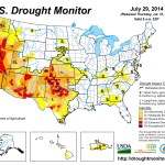
Click here to visit the US Drought Monitor website. Here’s an excerpt:
Summary
Spotty showers were heaviest in the East, where rain benefited pastures and summer crops. Meanwhile, mostly dry weather prevailed in the Midwest, except for a few bands of locally heavy showers. Despite a July drying trend, most Midwestern crops continued to thrive due to near- to below-normal temperatures and abundant soil moisture reserves. On July 27, USDA rated three-quarters of the U.S. corn and 71% of the soybeans in good to excellent condition—the highest such ratings this late in the season since 2004. Farther west, hot weather on the Plains yielded to sharply cooler conditions. In addition, rain overspread the central and southern High Plains late in the drought-monitoring period. The spell of hot weather hastened winter wheat maturation on the northern Plains and promoted rapid crop development throughout the nation’s mid-section. However, the Plains’ high temperatures also stressed some summer crops, especially in areas dependent upon rain or with lingering subsoil moisture deficits. Elsewhere, heat also arrived across the Southwest during a temporary break in the monsoon circulation, while cooler weather and beneficial showers overspread the Northwest. In particular, Northwestern showers aided containment efforts for a rash of lightning-sparked wildfires. However, the weather pattern reversed during the second half of the drought-monitoring period, with heat returning to the Northwest and a monsoon surge delivering heavy rain to parts of the Southwest…
California
Increasingly, drought indicators point to the fact that conditions are not appreciably better in northern California than in central and southern sections of the state. In addition, mounting evidence from reservoir levels, river gauges, ground water observations, and socio-economic impacts warrant a further expansion of exceptional drought (D4) into northern California. For California’s 154 intrastate reservoirs, storage at the end of June stood at 60% of the historical average. Although this is not a record for this time of year—the standard remains 41% of average on June 30, 1977—storage has fallen to 17.3 million acre-feet. As a result, California is short more than one year’s worth of reservoir water, or 11.6 million acre-feet, for this time of year. The historical average warm-season drawdown of California’s 154 reservoirs totals 8.2 million acre-feet, but usage during the first 2 years of the drought, in 2012 and 2013, averaged 11.5 million acre-feet.
Given the 3-year duration of the drought, California’s topsoil moisture (80% very short to short) and subsoil moisture (85%) reserves are nearly depleted. The state’s rangeland and pastures were rated 70% very poor to poor on July 27. USDA reported that “range and non-irrigated pasture conditions continued to deteriorate” and that “supplemental feeding of hay and nutrients continued as range quality declined.” In recent days, new wildfires have collectively charred several thousand acres of vegetation in northern and central California. The destructive Sand fire, north of Plymouth, California—now largely contained—burned more than 4,000 acres and consumed 66 structures, including 19 residences…
Northern Plains and Midwest
Patchy July dryness across the northern Plains and Midwest stood in stark contrast to near-record to record-setting June wetness. In one of the more dramatic examples, Sioux Falls, South Dakota, received rainfall totaling 0.80 inch (28% of normal) from July 1-29, following its wettest June and month on record (13.70 inches, or 349%). Due to antecedent wetness and persistently cool conditions, impacts from July dryness have been slow to emerge. However, pockets of abnormal dryness (D0) have begun to develop in a few areas of the western and southwestern Corn Belt. In addition to Sioux Falls, July 1-29 rainfall totaled less than an inch in locations such as Lincoln, Nebraska (0.51 inch); Mobridge, South Dakota (0.53 inch); Aberdeen, South Dakota (0.70 inch); Chesterfield, Missouri (0.70 inch); Valley, Nebraska (0.88 inch); Mason City, Iowa (0.90 inch); and Cahokia, Illinois (0.99 inch). By July 27, about one-sixth of the rangeland and pastures rated in very poor to poor condition Montana and Nebraska (16% in both states). On the same date, topsoil moisture ranged from one-quarter to one-half very short to short in several states across the northern Plains and Midwest, including Montana (48%), Nebraska (41%), Missouri (39%), South Dakota (29%), and Michigan (26%)…
Northwest
Washington State’s largest wildfire on record, the quarter-million acre Carlton complex—sparked by lightning on July 14—was largely contained by month’s end. Still, the complex of four fires (Stokes, Gold Hikes, French Creek, and the Cougar Flat fires) was enormously destructive while burning through timber, grass, and brush, with more than 300 homes destroyed in the Okanogan County communities of Brewster and Pateros. Following a brief cool spell, intense heat returned across much of the Northwest late in the month. On July 29, daily-record highs in Washington included 107°F in La Crosse and 105°F in Wenatchee. Farther south, moderate to extreme drought (D1 to D3) crept northward in eastern Oregon. Meanwhile, widespread, out-of-season rainfall accompanied the brief cool spell in the Pacific Northwest, allowing for the elimination of abnormal dryness (D0) along the coast and some erosion of moderate drought (D1) in northwestern Oregon. From July 22-24, Oregon rainfall totals reached 1.04 inches in Portland and 0.98 inch in Astoria…
Southern Plains
Cooler, showery weather late in the period helped to offset the effects of several hot days, resulting in only minor changes to the drought depiction. There were some improvements noted in a few areas, including Texas’ northern panhandle, where the coverage of extreme to exceptional drought (D3 to D4) was further reduced. A bit farther south, Lubbock, Texas, received 10.46 inches of rain (146 percent of normal) from May 1 – July 29, helping to dent the 30.47-inch precipitation deficit that accumulated from January 2011 – April 2014. Effects of the southern Plains’ long-term drought can still be observed in low lake levels and subsoil moisture shortages. On July 27, USDA reported that subsoil moisture was rated 65% very short to short in both Oklahoma and Texas. Rangeland and pastures have exhibited some recovery and are currently rated just 24% very poor to poor in Texas, along with 20% in Kansas and 19% in Oklahoma…
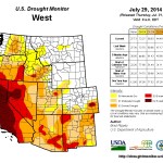
Southwest
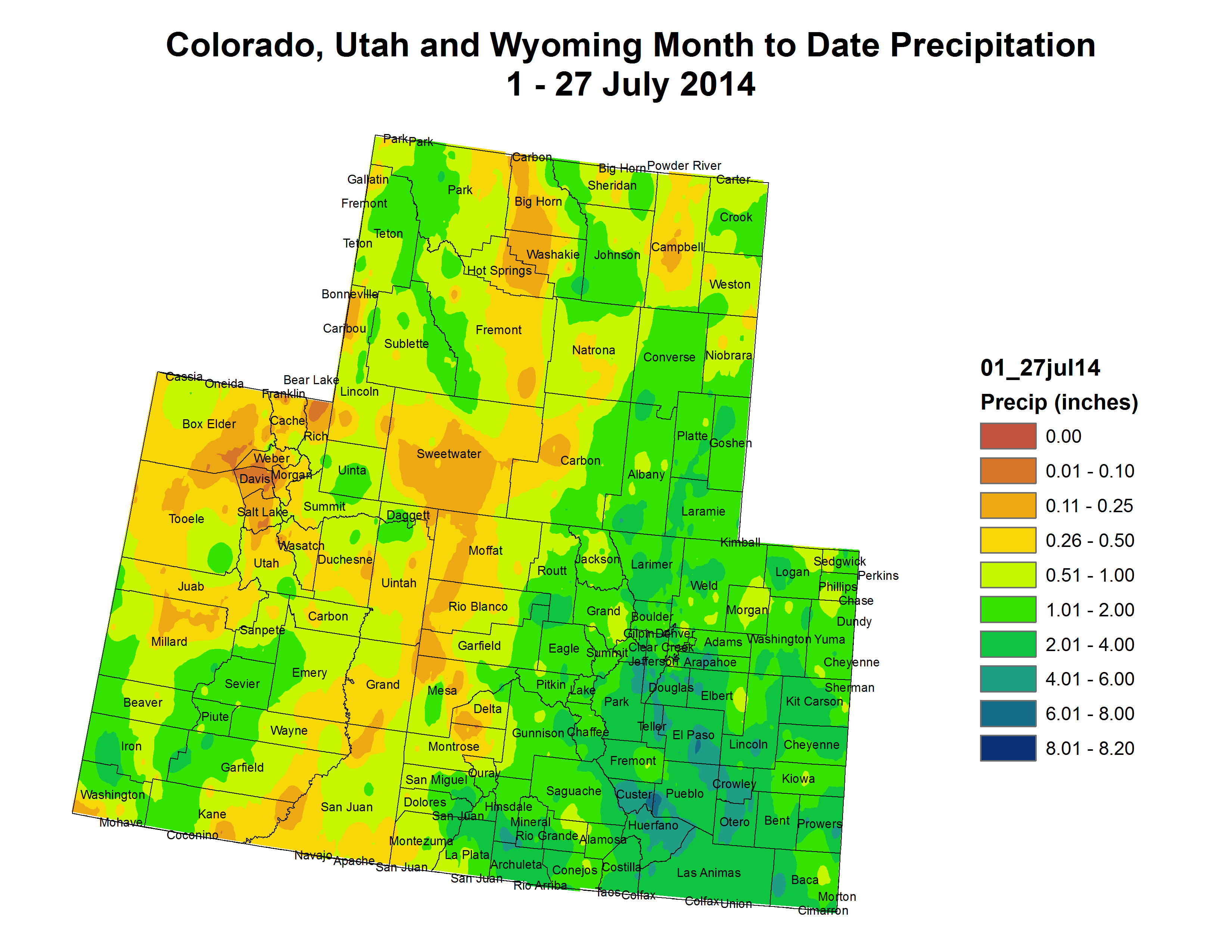
Robust monsoon rains, especially late in the monitoring period, chiseled away at long-term drought. Some of the greatest improvements in the drought depiction were noted across New Mexico and southern Arizona. Through July 29, month-to-date rainfall has totaled more than twice normal in several New Mexico locations, including Albuquerque (3.34 inches, or 242 percent of normal). Still, New Mexico’s rangeland and pastures were rated 65% very poor to poor on July 27, slightly worse than the late-July, 5-year average of 62%. In addition, New Mexico’s subsoil moisture was rated 67% very short to short. Similar conditions existed in other Southwestern States, with very short to short subsoil moisture ratings standing at 70% in Nevada, 68% in Utah, and 58% in Colorado. Meanwhile, Lake Mead—above Hoover Dam—which serves multiple states, recently fell to its lowest level since being filled during the 1930s…
Looking Ahead
From July 31 – August 4, locally heavy showers will shift eastward across the South, eventually reaching the southern Atlantic States. Five-day rainfall totals could reach 1 to 3 inches from Florida into the southern mid-Atlantic region. Meanwhile, showers will linger across the central and southern Rockies in the wake of a significant rainfall event. Most of the remainder of the West will experience dry weather, except for isolated showers across the Great Basin and Intermountain region. Mostly dry weather will also prevail during the next several days from the northern Plains into the middle Mississippi Valley. Elsewhere, an ongoing heat wave in the Northwest will contrast with near- to below-normal temperatures in most other parts of the country.
The NWS 6- to 10-day outlook for August 5 – 9 calls for the likelihood of below-normal temperatures in large sections of the central and eastern U.S., as well as the central Rockies, while hotter-than-normal conditions will cover the lower Southeast, the lower Rio Grande Valley, and the Far West. Meanwhile, near- to above-normal rainfall across the majority of the U.S. will contrast with the likelihood of drier-than-normal conditions in the Pacific Northwest, northern Plains, far upper Midwest, and southern parts of Arizona, Texas, and Florida.
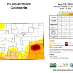
Recent monsoonal thunderstorms have soaked the Front Range with more rainfall than usual, but Colorado is not out of the dust bowl. Because droughts are fixed with snow, not rain.
According to the most recent report from the U.S. Drought Monitor, there has been some improvement in drought conditions across most of south-central and southeast Colorado.
“Currently, more than half of the state is free of drought while 40 percent is experiencing drought ranging from abnormally dry to exceptional,” the monitor’s July 2014 Drought Update said.
“The drought that is impacting southeastern Colorado is now well into its fourth year, but recent rains have brought some relief.”
Across the southeastern plains, the area in extreme drought decreased by 5.58 percent and the area in severe drought dropped by 1.75 percent from July 1 to July 25, the report showed. Only 0.92 percent of southeastern Colorado remained in exceptional drought, down from 1.89 percent at the start of the month…
And while the recent wet weather helps, Brian Bledsoe, chief meteorologist of Gazette news partner KKTV 11 News, said Wednesday that more is needed to alleviate the conditions brought on by four years of drought across southern Colorado.
“The damage that the drought has done over the past four years has been really widespread, and it has affected the soil’s ability to absorb moisture,” Bledsoe said. “I would equate it with pouring a glass of water over a kitchen table.”
Even if daily showers continue into next week, as predicted, National Weather Service meteorologist Eric Petersen said it will take more than one monsoon season to fully revitalize the state.
“For most of the summer a lot of the eastern plains have been a little wetter than normal, and this July several heavy thunderstorms over the plains have helped the drought areas,” Petersen said.
“We all need to be aware that while we’ve had a fairly wet pattern for the past couple of months, the drought takes shape through several years, and it will take much more than a couple of months of rain to take care of it,” he said…
Statewide reservoir storage is strong, with some providers reporting their best yields since 2001. The northern portion of the state is seeing higher storage levels than the southern half, according to the monitor report.
Exceptional drought conditions are now confined to southwestern and west-central Kiowa County, extreme northern Bent County, extreme southeastern Crowley County and extreme northeastern Otero County, the report said.
With the exception of extreme southeastern El Paso County, the rest of the Pikes Peak region was determined to be drought-free.
Years ago, the South Platte River ran down the center of four channels running by Julesburg. Over time, the moving of water in the channels built a dam and transferred the water to the channel furthest south. This divergence has caused major problems over the years, and flooding in the past two years has only made those problems worse. The Town of Julesburg, Sedgwick County and State of Colorado are now taking steps to fix those problems and move the river back to it’s original channel.
Town Manager Allen Coyne said that it’s not going to be an easy fix to solve all of the problems in the river. Over 40-50 feet of riverbank has been eroded on the south channel since the flooding in September 2013. One 6 inch water line has been broken, and other damage has been done to fiber optic conduits.
The State Workers are also renovating the bases of the bridge, because the foundation is showing because all of the water erosion.
Town Manager Allen Coyne said that about two weeks ago a waste water line had broken. Allen said that the Town is using a temporary waste water line while the other one is being replaced, so there is no waste in the river. Coyne would continue to say that they will fix some older problems, like the 6 inch conduit that has been broken for a couple of years. You may have seen this pipe sticking out of the water on the east side of the bridge. The 6-inch cast iron water line that was installed in 1969 was broken in the September 2013 flood.
All interstate businesses continue to have service with a permanent 10-inch water line. While surveying the damage from the floods, the crews found a few 4-inch fiber optic conduits had broken. The optic lines themselves are fine, but the conduits holding them are cracked. These lines are said to belong to PC Telecom and RNHN (which connects over 20 rural hospitals together).
The Town is looking for help from the Department of Homeland Security and Emergency Management for money to help fund the project. The Town is working with Concrete and Utilities Specialist, Alan Keir, who put in the last water line in 2005 and whose dad put in the 1969 water line. The Town has also applied to the Army Corps of for a permit to perform the repairs.
U.S. Rep. Scott Tipton on Wednesday was in a fighting mood when he joined House Republicans in grilling the Environmental Protection Agency’s deputy chief about a proposed rule that many farmers fear would allow the EPA to regulate small bodies of water, even ponds or puddles on their land.
Deputy Administrator Bob Perciasepe said the proposal simply clarifies regulatory authority under the Clean Water Act to protect streams and wetlands. That authority has been murky thanks to confusing and complex guidelines following Supreme Court decisions in 2001 and 2006.
But Tipton worries the proposed rule is too far-reaching, and in a testy exchange with Perciasepe during a House Small Business Committee hearing, he pushed him for clarification on what the new rule would encompass and what sort of exemptions would be available for agriculture.
“I live in the Southwestern United States in Colorado, we get one rainstorm and with the lay of our land, you can have a high water mark caused by a 10-minute flow that then disappears …” Tipton said.
“I’m just trying to get down to the actual definition, because it’s the arbitrary nature of this rule …” he continued.
Perciasepe interrupted, “It is not arbitrary, sir. If you’d let me answer I can give some clarity …
“In the science of hydrology, you can look at … an area where water would flow … it will exhibit characteristics on the ground … and if you don’t have those characteristics, then there’s not enough frequency of flow or volume of flow that would make it jurisdictional under the Clean Water Act,” Perciasepe said.
The EPA proposed the joint rule in March with the U.S. Army Corps of Engineers. The administration is hopeful that in addition to offering clarity, it would help businesses by increasing efficiency of the environmental agency.
Perciasepe repeatedly said the rule would not protect any new types of waters that have not historically been covered under the Clean Water Act. He also said it is in keeping with Supreme Court guidance.
Specifically, the rule would clarify that most streams and wetlands are protected. The rule-making comes as polluters have escaped fines for violations because the EPA has been uncertain that its authority would hold up in court.
Before the EPA finalizes the rule, Tipton said the agency should hold listening sessions in rural parts of Colorado and the nation. He has made the same request concerning a proposal to set carbon-pollution standards. The EPA ended two days of hearings in Denver on Wednesday over that issue.
The Durango Herald has confirmed that the EPA is working on a hearing for the Craig area in September to address the carbon issue. But no rural meetings have been discussed for the water rule…
“Wouldn’t it be appropriate when we’re doing these hearings … to actually go to the impacted communities, rather than just go to urban areas? …” Tipton asked. “It’s important that when we’re talking about outreach … to not discard rural America.”
Perciasepe responded, “Hearings are just one aspect of our outreach … the EPA will meet with anybody who wants to meet with us … We are going to reach out to virtually every state and the constituencies in each one of those states.”
Tipton also presented a letter from the Waters Advocacy Coalition, a diverse group of construction, business, mining and agriculture interests. The coalition expressed worries that the rule would have a greater impact on businesses than the EPA estimates.
More Environmental Protection Agency coverage here.
FromAspen Journalism via the Aspen Daily News (Brent Gardner-Smith):
The Colorado River District is the first governmental entity to throw cold water on the idea of designating 39 miles of the Crystal River as “wild and scenic.” At its July 15 meeting, three members of the river district board voiced opposition to the proposal to make the Crystal the second river in Colorado, after the Poudre River, to be designated under the Wild and Scenic River Act of 1968.
“Their main concern is that it would be an overlay of federal authority in this area that would preclude the ability to provide for water resource needs,” said Dave Merritt, who represents Garfield County on the board of the river district, a regional entity that levies taxes in 15 Western Slope counties to build water projects and influence water policy.
Chris Treese, the river district’s external affairs manager, had urged board members in a July 1 memo to “respectfully decline to support” Wild and Scenic designation on the Crystal.
“Staff believes Wild and Scenic designation would have adverse consequences for local residents,” Treese wrote. “We view proponents’ Wild and Scenic designation is (sic) a means to an end in an effort to forever foreclose water development opportunities in the Crystal River basin.”
In 2013, the river district gave up conditional water rights it held for two large dams on the Crystal after being sued in water court by Pitkin County and other groups.
Merritt made his remarks on Monday during the monthly meeting of the Colorado River Basin Roundtable, where two proponents of Wild and Scenic designation on the Crystal — Bill Jochems and Dorothea Farris — had a presentation.
Over the last year-and-a-half of making such presentations, they said they had received positive feedback and direction to continue exploring Wild and Scenic designation from the towns of Carbondale and Marble, the Redstone Community Association, Gunnison County, Pitkin County’s Healthy Rivers and Streams board and Pitkin County’s Crystal River Caucus.
But the Colorado River District will not be added to the list of supporters.
“That was the one audience where we had definite opposition,” Farris said on Monday.
Jochems said the three river district board members who spoke against Wild and Scenic on July 15 “expressed opposition, apparently, at the very idea of Wild and Scenic designation, without really talking about the Crystal.”
On Monday, roundtable members asked some questions concerning the potential impact on irrigators in the Crystal River, but did not take a position as a group on the proposal.
Jochems and Farris represent an informal citizen’s coalition that has come together to explore, and now actively pursue, Wild and Scenic designation for the Crystal, which would prevent a federal agency from approving, or funding, a new dam or reservoir on the river.
In late 2012, four organizations brought people together to discuss the idea: Pitkin County, the Roaring Fork Conservancy, the Crystal Valley Environmental Protection Association (CVEPA) and the nonprofit, American Rivers. The result was the naming of a three-person committee to test the regional waters and see if there was support for the idea.
Jochems serves on Pitkin County’s Healthy Rivers and Streams board and is a member of CVEPA, while Farris is a former Pitkin County commissioner and a resident of the Crystal River valley. The third member on the committee is Chuck Oligby, who owns Avalanche Ranch along the Crystal and sits on the Colorado River Basin Roundtable.
“We want to move forward,” Farris told the roundtable on Monday.
Three reaches
The current proposal is to designate 39 miles of the Crystal River as Wild and Scenic, while more specifically designating three sections as either “wild,” “scenic” or “recreational.” The three designations are not literal, as all of the Crystal could be considered “scenic” by anyone who sees it, but are classifications that reflect the level of human incursion along a river.
The headwaters of both the North Fork and the South Fork of the Crystal would be designated as “wild” under the law, as they flow through primitive backcountry areas with few, if any, roads. The North Fork, for example, first rises behind the Maroon Bells in the Snowmass-Maroon Bells Wilderness. Together, about nine miles of the two upper forks would be managed as “wild” down to their confluence in Crystal City, above Marble.
The next 10 miles of the Crystal, down to Beaver Lake in Marble, would be considered “scenic,” as there is a dirt road along the river in that reach.
And the next 20 miles, between Marble and the Sweet Jessup Canal diversion structure, 10 miles above the river’s confluence with the Roaring Fork River, would be considered “recreational,” due in large part to the paved road along the river.
“What we’re seeking here is a very stripped down version of a Wild and Scenic designation,” Jochems told the roundtable on Monday. “We propose to leave land-use control entirely with Gunnison and Pitkin counties, as it is now. We don’t propose any further federal control over land use. We don’t want features that would allow any condemnation of property. All we’re concerned about is the main stem of the Crystal River and keeping it free of dams.”
Merritt of the river district, however, pointed out that national environmental groups have opposed “stripped-down” versions of Wild and Scenic in the past, as they are concerned about weakening the federal law.
Screen shot from Peter McBride’s video arguing that the Crystal River should be left as is
The U.S. Forest Service first found the Crystal River as “eligible” for Wild and Scenic status in the 1980s and re-affirmed that finding in 2002. Much of the land along the Crystal, from the headwaters to the Sweet Jessup head gate, is owned by the Forest Service.
The next step in the Wild and Scenic process is for a river to be determined “suitable” by the Forest Service, which requires an extensive study under the National Environmental Policy Act (NEPA), and then congressional action.
Another option is for legislation to be submitted directly to Congress, which could then potentially approve Wild and Scenic designation after a less formal study.
Jochems said Wednesday, in an interview, that the three-member committee seeking designation has been meeting with Kay Hopkins, an outdoor recreation planner with the Forest Service, to seek guidance on draft legislation.
The draft bill, Jochems said, is then to be circulated among the towns, counties and other entities that have expressed an opinion so far, and see what details need to be worked out. If legislation can be agreed upon by local entities, a congressional sponsor would then be sought, Jochems said.
Editor’s note: Aspen Journalism is collaborating with the Aspen Daily News on coverage of land and water issues in Pitkin County. More at http://www.aspen journalism.org.
Click here to view Peter McBride’s short video “Crystal Voice.” More Crystal River coverage here.