
From The Pueblo Chieftain (Chris Woodka):
Would a dam on Fountain Creek make a difference in a situation such as last week’s drainage along the Arkansas River?
“It is something we need to talk about,” Water Division 2 Engineer Steve Witte said Monday, looking back at a wild ride of a week on the river. “It’s a discussion that needs to take place. It seems to me at some point there will be a balance between water rights and property rights.”
The Arkansas Basin Roundtable earlier this month turned away a grant request from the Fountain Creek Flood Control and Greenway District to study the practical effects of building a dam or system of detention ponds on Fountain Creek.
Chief among objections: the damage to junior water rights. By changing the peak flow on Fountain Creek floods — delaying the time it takes water to reach points downstream — junior water rights might not come into priority.
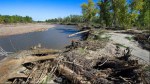
On the other hand, the peak flows that came crashing off the prairie into already full canals caused three of them to blow out after storms early last week.
“We already have an example, Pueblo Dam, of how we can reduce flood damage,” Witte said. “On the South Platte, they already are using upstream, out-of-priority storage. They use the water where it exists and determines who gets it later.”
Answering the basic question of whether those types of programs might work on Fountain Creek — the largest single tributary to the Arkansas River in Colorado — needs to be explored. Otherwise the only option to catch floodwater below Lake Pueblo is John Martin Reservoir, Witte said.
“I hope they’ll come back with a revised request,” he said.
One of the problems with last week’s storms is that much of the water was flowing in from unmeasured creeks and gullies. There are no gauges on Chico Creek or Kramer Creek, both a few miles east of Pueblo. Chico Creek boosts flows past the Avondale gauge, but no one can be sure just how much is being contributed to the river. The break in the Colorado Canal was caused by heavy flows on Kramer Creek near Nepesta.
“We were just flying blind,” said Witte, who witnessed the flooding at Nepesta.
The water from several tributaries hit the Arkansas River at the same time, creating “waves” that peaked quickly and then subsided. Some falsely high readings caused unnecessary worries downstream, where no major flooding occurred.
While the system of satellite river gauges has grown in the past 25 years, and provide easy access to information on the Internet, some malfunctioned during last week’s storms. Division of Water Resources staff scrambled to find out what was happening.
“I think we’ve improved, but there is still an element of human judgment,” Witte said. “We need to have people on the ground to verify if our gauges are accurate.”