
Waters that have never been protected remain outside the scope of the Clean Water Act. #ditchthemyth http://t.co/oQEXphX8QY
— U.S. EPA Water (@EPAwater) July 24, 2014
Month: July 2014
Drought news
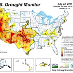

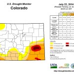
Click here to go to the US Drought Monitor website. Here’s an excerpt:
Summary
Early in the period, a strong cold front brought unseasonably cool air (and dozens of daily record or near-record minimums and low maximums) to the eastern two-thirds of the Nation while also triggering numerous showers and thunderstorms across the southern and central Plains, lower Mississippi Valley, Southeast, mid-Atlantic, and coastal New England. Lows dropped into the forties as far south as Kansas, and 7-day temperatures averaged more than 12oF below normal in Oklahoma and Arkansas. Another cold front late in the week dropped heavy rain on northern sections of North Dakota and Minnesota. In contrast, a ridge of high pressure over the West kept the weather hot and mostly dry. Weekly temperatures averaged 4 to 8oF above normal in the Northwest and Great Basin, with highs reaching triple-digits in many locations. Numerous large active wild fires were reported in the Far West, particularly in Washington and Oregon. Wetter weather was reported in both Hawaii and Puerto Rico, but the heaviest rains fell on areas without D0 or D1…Pacific Northwest
A second consecutive week of hot (temperatures averaged 4 to 8oF above normal, triple-digit highs) and mostly dry weather greatly increased moisture demand across the region. Numerous large active wild fires, many triggered by lightning strikes from dry thunderstorms, were reported in the West. As of July 23, Oregon had 13 active large wildfires totaling more than 578,000 acres, while Washington had 5 large active fires affecting almost 300,000 acres, according to NIFC. Although July precipitation is normally low, the combination of hot weather and no rain has exacerbated conditions, resulting in the expansion of D0 along the Washington coast, just east of the Washington Cascades, across north-central Idaho, and into parts of western and central Montana based upon 30- and 60-day shortages. In the latter state, recent heat, spotty rains, and windy conditions have quickly decreased moisture conditions from June into July. In southeastern Oregon, light rain (0.1-0.4 inches) on day 7 of the period in Malheur and Harney counties helped wet one of the largest fires (Buzzard Complex), but dry and hot weather in southwestern ( Jackson County) and central Oregon (Deschutes, Crook, and Grant counties) expanded D3 and D2, respectively. In Idaho, irrigation water was shut off this week for Magic Reservoir and Salmon Falls water users, while Little Wood Reservoir irrigators will be out of water soon – earlier than last year. Owyhee Reservoir is nearly empty, and ran out of available water much earlier than last year…Southern and Central Plains
Widespread moderate to heavy showers and thunderstorms, plus unseasonably cool air, highlighted a very beneficial and welcome weather week for much of the region. Southeastward tracking thunderstorms dropped swaths of ample rain (>2 inches) on southwestern Kansas, central and southeastern Oklahoma, southwestern Arkansas, eastern Texas, and most of Louisiana. Additional heavy rains fell on southeastern Colorado, the Texas Panhandle, along the Red River Valley, and on central and southwestern Texas. Even after a dry 7-day period in much of Texas last week, 60-day precipitation is generally at or above normal in most of the state, along with Oklahoma, Kansas, New Mexico, and eastern Colorado. The issue, however, is to balance the short-term wetness with the long-term (multi-year) drought which has impacted hydrological interests. Taking this into consideration, 1-category improvements were made in most areas where this week’s rainfall exceeded 2 inches. A 2-category improvement (D1 to nothing) was made in extreme southeastern Texas (Jefferson County) were 8-10 inches fell. A few areas were slightly degraded as the rains missed the extreme southern Texas coast and parts of the west Texas. The July 20 NASS/USDA state summaries mentioned that pastures were greening up across much of Texas and Oklahoma with the recent rains and lower temperatures, and most crops benefited from the moisture and lack of excessive heat. 28-day average USGS stream flows were spotty in Texas, but most sites in Texas, Oklahoma, and Kansas were in the normal (25-75th percentile) category, including several stations in northern Texas in the above to much-above normal categories…Southwest and Great Basin
Somewhat similar to the southern Plains, abundant moisture triggered scattered moderate to heavy showers and thunderstorms in parts of New Mexico and southeastern Colorado, but totals quickly dropped to zero in western sections (e.g. most of Arizona, Utah, western Colorado, southeastern California). And like the southern Plains, the balancing of short-term wetness and long-term drought tempered the potential improvements in New Mexico and southeastern Colorado. Nevertheless, where decent rains (more than an inch) fell this week and Water Year-to-date surpluses existed, a 1-category improvement was made, namely in central New Mexico (north to south) – D3 to D2, and in southeastern Colorado. D3 was slightly expanded to reflect similar conditions at various time scales in north-central New Mexico and northeastern Arizona. In northeastern Utah, hot and dry conditions justified a general 1-category downgrade to reflect poor soil and vegetative health models. Monsoonal moisture made it north and west into the central Sierra Nevada and Lake Tahoe area, producing showers and thunderstorms that dropped 0.3-1 inches, locally to 3 inches, but these totals weren’t even close to making a dent in the long-term drought. In California, the June 30 reservoir update (based upon 154 intrastate reservoirs) had storage at 60% of average – better than this time in 1977 where storage was at a record low of 41%. Storage totaled 17.25 million acre feet (maf), and a typical seasonal withdrawal is 8.24 maf. The last two years (2012 and 2013), withdrawal has topped 11 maf. Due to early melting of this year’s meager snowpack, withdrawal through June 30 was already at 2.1 maf (versus average withdrawal through June 30 of less than 0.6 maf)…Looking Ahead
During July 24-28, wet weather is forecast for the eastern third of the Nation, Pacific Northwest, and parts of the northern and south-central Plains. Later in the period, some monsoonal moisture is expected to trek northward into Arizona, New Mexico, and Colorado and trigger scattered light to moderate showers. Little or no precipitation for the 5-day period is expected in California and the Great Basin, north-central Rockies, southern Plains, and central Great Plains. Temperatures should average below normal across the northern tier of States and above normal across the southern third of the U.S., with the greatest positive departures in the Southwest.For the ensuing 5-day period, July 29-August 2, the odds favor above median precipitation from the eastern Great Basin and Arizona southeastward along the Gulf Coast and northeastward along the southern and middle Atlantic Coast. Sub-median precipitation is likely in the Pacific Northwest, and from the northern Plains and upper Midwest southeastward into the Tennessee Valley. Western Alaska is expected to observe below median rainfall, with the opposite forecast in the southeastern Panhandle. An expected strong ridge of high pressure over the Far West and a deep trough over the eastern U.S. will favor strong chances of above-median temperatures in the West and below-median readings in the eastern half of the U.S.
New study from @UCIrvine finds groundwater loss greater threat to western US than understood #ColoradoRiver
New study from @UCIrvine & @NASA finds groundwater loss greater threat to western US than understood http://t.co/lXCWlRU1gX #Drought
— UC Water Institute (@ucanrwater) July 24, 2014
Here’s the release:
A new study by NASA and University of California, Irvine, scientists finds more than 75 percent of the water loss in the drought-stricken Colorado River Basin since late 2004 came from underground resources. The extent of groundwater loss may pose a greater threat to the water supply of the western United States than previously thought.
This study is the first to quantify the amount that groundwater contributes to the water needs of western states. According to the U.S. Bureau of Reclamation, the federal water management agency, the basin has been suffering from prolonged, severe drought since 2000 and has experienced the driest 14-year period in the last hundred years.
The research team used data from NASA’s Gravity Recovery and Climate Experiment (GRACE) satellite mission to track changes in the mass of the Colorado River Basin, which are related to changes in water amount on and below the surface. Monthly measurements in the change in water mass from December 2004 to November 2013 revealed the basin lost nearly 53 million acre feet (65 cubic kilometers) of freshwater. That’s almost double the volume of the nation’s largest reservoir, Nevada’s Lake Mead. More than three-quarters of the total — about 41 million acre feet (50 cubic kilometers) — was from groundwater.
“We don’t know exactly how much groundwater we have left, so we don’t know when we’re going to run out,” said Stephanie Castle, a water resources specialist at the University of California, Irvine, and the study’s lead author. “This is a lot of water to lose. We thought that the picture could be pretty bad, but this was shocking.”
Water above ground in the basin’s rivers and lakes is managed by the U.S. Bureau of Reclamation, and its losses are documented. Pumping from underground aquifers is regulated by individual states and is often not well documented.
“There’s only one way to put together a very large-area study like this, and that is with satellites,” said senior author Jay Famiglietti, senior water cycle scientist at JPL on leave from UC Irvine, where he is an Earth system science professor. “There’s just not enough information available from well data to put together a consistent, basin-wide picture.”
Famiglietti said GRACE is like having a giant scale in the sky. Within a given region, the change in mass due to rising or falling water reserves influences the strength of the local gravitational attraction. By periodically measuring gravity regionally, GRACE reveals how much a region’s water storage changes over time.
The Colorado River is the only major river in the southwest part of the United States. Its basin supplies water to about 40 million people in seven states, and irrigates roughly four million acres of farmland.
“The Colorado River Basin is the water lifeline of the western United States,” said Famiglietti. “With Lake Mead at its lowest level ever, we wanted to explore whether the basin, like most other regions around the world, was relying on groundwater to make up for the limited surface-water supply. We found a surprisingly high and long-term reliance on groundwater to bridge the gap between supply and demand.”
Famiglietti noted that the rapid depletion rate will compound the problem of short supply by leading to further declines in streamflow in the Colorado River.
“Combined with declining snowpack and population growth, this will likely threaten the long-term ability of the basin to meet its water allocation commitments to the seven basin states and to Mexico,” Famiglietti said.
The study has been accepted for publication in the journal Geophysical Research Letters, which posted the manuscript online July 24. Co-authors included other scientists from NASA’s Goddard Space Flight Center, Greenbelt, Maryland, and the National Center for Atmospheric Research, Boulder, Colorado. The research was funded by NASA and the University of California.
For more information on NASA’s GRACE satellite mission, see: http://www.nasa.gov/grace and http://www.csr.utexas.edu/grace
More groundwater coverage here.
SDS construction reaches Colorado Springs ahead of schedule and under budget — The Colorado Springs Gazette

From The Colorado Springs Gazette (Emily Donovan):
Huge pipes being tunneled underground near the intersection of Powers Boulevard and Constitution Avenue is the first big sign after almost two decades of work to increase the water available to the Colorado Springs area by a third…
Pipeline construction at the busy intersection is ahead of schedule, expected to be complete in September rather than November, said SDS spokesperson Janet Rummel…
A $125 million facility that will be able to process 50 million gallons of water a day, the treatment plant on the east side of Colorado Springs is halfway constructed, also ahead of schedule. Construction began in March 2013 and will be finished in fall of 2015. The plant is expected to put out drinking water in April 2016…
SDS construction is estimated to cost $847 million – $147 million less than the original estimation in 2009.
Rummel said money was saved by asking engineers to make designs that would be cost-effective without damaging drinking water quality, like keeping every part of the water treatment plant under the same roof instead of separate buildings.
This means SDS will cause less of a utilities rate increase for CSU customers than originally expected in 2009…
“This is the future of Colorado Springs,” said Jay Hardison, CSU water treatment plant project manager.
River restoration projects mostly fine despite runoff — The Leadville Herald Democrat

From the Leadville Herald Democrat (Danny Ramey):
Heavy spring runoff did not have a major impact on several river restoration projects in the Arkansas River basin.
Members of the Lake County Open Space Initiative toured the three different projects on Thursday, July 10. Each of three projects used a different method to help preserve or restore the river.
Last year, Colorado Parks and Wildlife worked to maintain and build habitat along the Arkansas River near Hayden Meadows. Logs and sod mats were used in the project to help stabilize the river banks while still allowing the river some space to move.
“That’s a natural thing rivers want to build,” Greg Policky, biologist for parks and wildlife, said. The goal of the project was to ensure that there is adequate habitat for each life stage of trout, Policky said.
During the spring, the Hayden Meadows area saw higher than average flows. Normally, flows measure around 300 to 400 cubic feet per second on that stretch of river. This spring flows reached up to 900/cfs, Policky said. Despite the heavy flow, most of the structures parks and wildlife put in held. However, there were a few problem areas. In one spot, the river ripped out the log supports and created a channel.
“It didn’t quite like everything we did,” Policky said.
The runoff also caused some erosion of the river banks in the 4-mile project area. Crews will be coming in near the end of July to maintenance the project. They will also extend the project another mile down the river.
Meanwhile, river restoration further up on the Arkansas River and the Lake Fork saw very little disturbance from the runoff.
Restoration work along that section of the river was done mostly with rocks to lower the chance of something coming loose and washing downstream.
“I put something in that I’m confident that I won’t move,” Greg Brunjak, who worked on the project, said.
Willows and logs were also used in parts of the project to stabilize the banks.
That particular project was performed mostly on private land along the Lake Fork. One of the project’s goals was to help eliminate erosion along the banks of the river and help maintain livestock habitat in the area.The structures can withstand up-flows of about 800/cfs, Brunjak said. That portion of the Lake Fork saw flows of around 200 and 250/cfs this winter, which were still higher then normal.
“We’ve got a pretty good flow we haven’t seen for awhile,” Brunjak said.
The Union Creek Project, located on a tributary off of the Arkansas River, saw minimal impact from the runoff as well. One of the main goals of the project was to stabilize a portion of the Old Stage Road. Union Creek had been cutting into the hill and destabilizing the road. The project was performed by Colorado Mountain College. Soil lifts and willows were used to help stabilize the bank of the creek below the road.
The one issue from the runoff came from a log structure built to help get water to some of the willows used in the project, Jake Mohrmann, assistant project manager of the CMC Natural Resource Management department, said. The structure ended up being too tight and was plugged by debris from the runoff, which caused the area behind the structure to dry up slightly. When crews unplugged the structure it caused a lot of sediment to flow through, Mohrmann said. The structure then plugged up again a few weeks later.“We will need to remove it and find another way to get water to the willows,” Mohrmann said.
More Arkansas River Basin coverage here.
Lower Dolores study details native fish needs — The Dolores Star

Mcphee Reservoir

Mcphee Reservoir construction

Mcphee dam

Dolores River near Bedrock

Dolores River Canyon near Paradox
From The Dolores Star (Jim Mimiaga):
A conceptual plan for aiding native fish on the Lower Dolores River was approved by the Dolores Water Conservancy District in June. The District has been negotiating with Colorado Parks and Wildlife, the BLM, Forest Service, and conservation groups on ways to improve native fish habitat below McPhee Dam. The result is the Lower Dolores River Implementation, Monitoring, and Evaluation Plan, focusing on three native fish: the flannelmouth sucker, bluehead sucker, and roundtail chub.
“The plan provides a more coordinated approach for improving native fish habitat, with a focus on additional monitoring,” said Amber Clark, with the San Juan Citizen’s Alliance.
After McPhee Dam was built, small spills, as well as non-spill years from 2001-2004, began reducing the quality and amount of habitat required to meet the needs of native fish. Spring releases from the dam are later in the season, which has reduced the chance for spawning and survival of native fish.
“Protecting the native fish species locally is important because the healthier they are, the less likely they will be seen by the (U.S. Fish and Wildlife) agency as requiring protective status under the Endangered Species Act,” said Ken Curtis, an engineer with the Dolores Water Conservancy District. “Working to help these species keeps control of our river at a local level.”
The implementation plan presents known and preferred habitat conditions and lifecycles of native fish within six separate stretches of the river below McPhee dam, four of which are a focus of conservation: Dove Creek Pump Station to Pyramid (Reach 3), Pyramid to Big Gypsum Valley (Reach 4), Slickrock Canyon (Reach 5), and Bedrock to San Miguel confluence (Reach 6) Reach 3 (nine miles)
Roundtail Chub are most abundant in Reach 3 and have a relatively stable population there. Mature roundtail are smaller than in other Western Slope rivers, indicating they are adapting to low flows. Fish counts at the Dove Creek area counted 140 roundtail chub, the highest in 13 years.
Bluehead and flannelmouth suckers are present, but in low abundance. In 2013, eight bluehead and one flannelmouth were counted. Habitat is good for bluehead, a more cold tolerant fish.
Reach 4 (38 miles)
Disappointment enters the Dolores in this stretch, flushing sediment into the main channel.
All three native species are found in this stretch as well as problematic non-natives including the black bullhead and smallmouth bass, a voracious predator.
Studies show that populations shift toward non-native species during prolonged low-flow periods. In 2004, native species made up less than 50 percent of the fish caught. After a prolonged spill in 2005, 84 percent of the fish sampled were flannelmouth sucker or roundtail chubs. Because of silt buildup from Disappointment Creek, improving flows here would especially help native fish beat out non-natives.
In August 2013, flooding showed that Reach 4 below Disappointment caused unnatural silting, causing a significant fish kill.
A lack of water limits critical dilution effects, and there is an unnatural buildup of silt because of infrequent flushing flows. “During a flash flood event on Disappointment, the surge of debris-filled water flows into the Dolores River, but there is no water to help dilute the surge of silt-laden water,” said Jim White, a CPW fish biologist.
Monitoring native species at Big Gypsum will remain a priority as it appears that the population may be sensitive to low flow.
Flows are a big factor. In 2005, when there was a managed spill, biologists found 150 flannelmouth per hectare at the Big Gypsum site. While in 2004 when there was no spill, flannelmouth were counted at five fish per hectare.
In April 2013, a PIT-tag array was installed across the river just above the Disappointment Creek confluence. Fish are implanted with grain-size microchips and can be detected when they move. Only a few fish have been tagged in the lower Dolores, but more implants are planned. Data shows native fish move up and down the river. The cost of the PIT-tag array is about $75,000.
Slickrock Canyon (32 miles)
All three native fish species are found,but in low abundance. This canyon is difficult to survey, and can usually be floated if there is a spill from McPhee reservoir. The last survey was in 2007, but more are needed to determine if the stretch has rearing habitats for native fish. A relatively large number of small native fish was found near the mouth of Coyote Wash, suggesting tributaries play an important role for young fish.
Bedrock to the San Miguel River confluence (12 miles)
There are a lot of unknowns. It is highly affected by natural salt loading through the Paradox Valley. The salinity is a barrier for fish between the Dolores River below the San Miguel and Slickrock Canyon. A salinity injection well is operated by the Bureau of Reclamation here to mitigate the problem. Researchers want to ascertain the levels of salinity. A second PIT-tag array is considered near Bedrock to help figure out how fish move .
Spill management
Mimicking a natural hydrograph for native fish is one goal of the implementation plan.
McPhee stores most of the Dolores River spring runoff, and exports much of the storage to the Montezuma Valley of the San Juan River Basin. The result is a lack of spring flushing flows in the Lower Dolores to move sediment and create natural habitat.
When inflow into the reservoir exceeds capacity, the spill benefits boaters and the downstream fishery. However, a prolonged drought has limited spill years. The reservoir holds a fishery pool of 29,824 acre-feet allocated downstream throughout the year by CPW. Spill water doesn’t count against the fishery pool, but it is subject to shortages in dry years.
The report suggests ways to optimize the fish pool and spills for the benefit of native fish.
Thermal regime management sends water downstream earlier, in March and April rather than in May, to keep water cooler and delay the fish spawn until after the whitewater season.
Biologists have documented that when spill water is released in May, the low flows on the lower Dolores have heated up, cueing fish to spawn early.
“The fry and eggs are washed away in the whitewater, a hit on survival,” White said.
A model indicates that flow volumes of 125-200 cfs on May 1 may be necessary to keep water below 15C at the Dove Creek Pumps. More water downstream may keep water cool enough to delay spawning. A gauge at James Ranch will monitor conditions.
Flushing flows range from 400-800 cfs are important to prepare spawning areas and improve oxygenated flow around eggs.
Habitat flows ranging from 2,000 cfs to 3,400 cfs are necessary for resetting channel geometry, scouring pools, creating channels for fish nurseries. The Bureau of Reclamation urges increasing the fish pool to 36,500 acre-feet a year. A fund of $400,000 is earmarked for buying additional water, but none has been acquired using these funds.
“There has always been a desire for more water for the downstream fishery,” says Curtis, of DWCD. “Before there is a blanket grab for additional water, there needs to be a specific focus on how it will help, and those questions are being pursued.”
The goal of the Implementation Plan is to maintain, protect, and enhance the native fish populations in the Dolores River.
The area is susceptible to being overrun by small mouth bass and affords opportunity for their suppression by removing caught fish.
Managed spills scour the river bottom, and move sediment in ways that benefit native fish and their young.
Blueheads are rarely detected in this stretch.
Biologists see the problem as two-fold:
The Snaggletooth Rapid is in this stretch, making fish sampling a challenge, but regular fish monitoring is encouraged in the report.
EPA: Our proposal to protect clean water preserves all exclusions and exemptions for agriculture
Our proposal to protect clean water preserves all exclusions and exemptions for agriculture. #ditchthemyth http://t.co/oQEXphX8QY
— U.S. EPA Water (@EPAwater) July 24, 2014
More Environmental Protection Agency coverage here.
Edwards: Eagle River Watershed Council screening of DamNation July 30

We are excited to host a screening of Patagonia’s new, award-winning environmental documentary, DamNation, at the Riverwalk Theater in Edwards! “This powerful film odyssey across America explores the sea change in our national attitude from pride in big dams as engineering wonders to the growing awareness that our own future is bound to the life & health of our rivers.”[…]
Doors open Wednesday, July 30th at 6:15 pm, screening starts at 7:00 pm. Tickets are $3 in advance, $5 at the door. For more information or to purchase tickets, call (970) 827-5406.
More Eagle River watershed coverage here.
“…the way things are structured right now, a traditional El Niño will struggle to form” — @BrianBledsoe

From Weather6280.com (Brian Bledsoe):
As you can see, a warmer than normal pool of water is located off the west coast of South America in areas referred to as Niño Regions 1+2. Farther west across the Pacific the water is actually a bit cooler than normal until you get to the western Pacific Ocean. In order for the El Niño to develop in a traditional fashion, the water must cool in the western Pacific Ocean allowing the Southern Oscillation Index to drop and the subsequent oceanic and atmospheric coupling to take place. Sounds like a lot of geek speak…but the way things are structured right now, a traditional El Niño will struggle to form. Recently the SOI has started to drop a bit, but has a long way to go to where it indicates a true El Niño.
East West Divide Apparent At Colorado Water Meeting #COWaterPlan

From KUNC (Stephanie Paige Ogburn):
Water managers are taking the next steps in formulating a statewide water plan, following a meeting where representatives from Colorado’s eight water basins met and presented drafts of their individual plans.
There have been longstanding tensions between the state’s Western side and the Front Range over water transfers, and those differences came through in some of the presentations.
“We are already a major donor of water to the Front Range of Colorado,” said Jim Pokrandt, a representative from the Colorado River District, which manages water for six counties in that basin on the Western Slope.
Sean Cronin, executive director of the St. Vrain and Left Hand Water Conservancy District, represents the South Platte and Metro interests in the state water plan discussions. In his presentation, Cronin pointed out the Front Range will likely need additional sources of water from the Colorado River.
“The South Platte Basin is in favor of further development of Colorado’s [Colorado River] entitlement,” Cronin said.
The difference between Pokrandt’s western perspective and Cronin’s eastern one has been in existence for decades, say water experts…
The Western Slope’s Pokrandt said that while he appreciates existing conservation efforts from certain entities like Denver Water, Aurora, and Colorado Springs, the Front Range could do a lot more overall to use its water more efficiently.
“That’s going to include addressing your urban conservation, how we landscape, appliances and things that we have in our house. And Colorado hasn’t totally embraced that,” he said.
From the metropolitan side, Cronin said he saw the South Platte as a “model throughout the state” from a conservation standpoint.
“We agree, we feel there can be more done in the way of conservation. Where it starts to get controversial is to what degree.”
Cronin said the Metro/South Platte roundtable favored the preservation of local control over water, shying away from any measures that might force municipalities to use water in certain ways.
Another big focus for the South Platte is keeping water in agriculture, rather than doing what is called “buy and dry,” allowing farmland to go dry while the water is used in cities.
On the flip side, the desire to keep water in agriculture in the state’s eastern side is part of what drives the need for more transfers from the west, noted Pokrandt.
More Colorado Water Plan coverage here.
Steamboat Springs: 1st Yampa River cleanup day of season is Monday
1st Yampa River cleanup day of season is Monday http://t.co/0AuU6KIyRY
— Pilot & Today (@steamboatpilot) July 23, 2014
Big Thompson Canyon: 1976 flood remembrance service set July 31 #BigThompson

From the Loveland Reporter-Herald:
The 38th remembrance service for the flood of 1976 will take place at 7 p.m. Thursday, July 31 at the memorial site at the Volunteer Fire Department, 1461 W. U.S. 34, one mile below from Drake.
The service will feature music, three scholarship awards and a speaker who worked for search and rescue in the flood, who had to rescue himself and survive the most recent flood.
There will be a dedication of the bronze memorial, sculpted by George Walbye, which will be placed at the site in memory of Evelyn Starner and Patty Goodwine, who were killed in the September 2013 flood.
For details, call Barb at 667-6465.
Here’s an Allen Best column from The Denver Post that ran last fall after the flooding in the Front Range canyons:
The recent rainfall along the Front Range was phenomenal, by some estimates a 1,000-year event in terms of duration, volume and area. But the flooding?
Not so much, at least as measured by an obelisk along Boulder Creek in downtown Boulder.
Human memories about weather are unreliable. During many years living in Vail, how often did I hear that the latest powder storm was absolutely the best ever? Plenty. Flooding is like that, too, but maybe in reverse.
The turquoise obelisk in Boulder provides a better measure against long-term memory loss. Located near the Broadway bridge, it provides benchmarks for flood levels. The water this year lapped against the 50-year marker. Above it are others: 100 years, 500 years and, much higher yet, Big Thompson, a reference to the giant flood in that canyon between Loveland and Estes Park in 1976.
I was at the Big Thompson disaster. I was living in Fort Collins then and was among scores of young men (sorry, women, those were different times) with strong backs who could be summoned in case of forest fires. My only fire was at an old sawmill site in the foothills. The joke was that one of us had set the fire because we were so desperate for minimum-wage work.
Then came July 31. It was hot that night in Fort Collins. It hadn’t rained a drop.
I was living above Gene’s Tavern, just two blocks from the Larimer County Courthouse. When the call came, I was at the sheriff’s office almost immediately. It was 9 p.m.
Being among the first at the command center at the Dam Store west of Loveland, near the mouth of Big Thompson Canyon, I was assigned to a pickup dispatched to look for people in the water near the turnoff to Masonville. Already, the river was out of its banks. From the darkness emerged a figure, dripping and confused. “I went fishing at Horsetooth (Reservoir) and was driving home and then there was all this water,” he sputtered. He was befuddled. So were we.
Our leader decided we’d best get out of there. From what I saw the next morning, that was an excellent decision. Water later covered the road there, too. I spent the night at the Dam Store as the water rose. Helicopters were dispatched, but there was little that could be done. Our lights revealed picnic baskets, beach balls and propane bottles bobbing in the dark, roiling water that raced past us, but never any hands summoning help.
In the morning, we found those hands. The bodies were stripped of clothing and covered with mud. The first I saw was of a woman who we guessed was 18, not much younger than I was then. This thin margin between life and death was startling in my young eyes.
Eventually, 144 people were declared victims of the flooding that night (although one turned up alive in 2008 in Oklahoma).
Estes Park got some rain, but not all that much. The larger story was partway down the canyon, in the Glen Haven and Glen Comfort areas, where the thunderstorm hovered. In just a few hours, it dropped 10 to 14 inches of water.
Downstream in the canyon, just above the Narrows, some people were unaware that anything was amiss until they went outside their houses and saw the water rising in their yards. It hadn’t even rained there. One cabin I saw a few days later was stripped of doors and windows but stood on its foundations, a mound of mud 5 or 6 feet high in the interior. I seem to recall a dog barking as we approached, protecting that small part of the familiar in a world gone mad.
At the old hydroelectric plant where my family had once enjoyed Sunday picnics, the brick building had vanished. Only the turbines and concrete foundation remained. In a nearby tree, amid the branches maybe 10 or 15 feet off the ground, hung a lifeless body.
The river that night carried 32,000 cubic feet per second of water at the mouth of the canyon, near where I was stationed. It happened almost instantaneously — and then it was gone. It was a flash flood.
This year, the flows peaked at 10,000 cfs, but were more sustained and, according to reports, the damage inexplicably greater in portions of the canyon. There were horrors, too, but this year there was time for warnings.
After the 1976 flood, rain gauges were sprinkled in the foothills of the Front Range, up to 7,500 feet in elevation, where most heavy summer rains occur. That telemetrically transmitted information alerts police chiefs and sheriffs to flooding potential. That warning system may have saved lives this year.
Where does volume of this flood fit into the context of flooding in the last 150 years? That answer will have to wait. Many rain gauges were swept away, so peak flows will have to be calculated during field visits by U.S. Geological Survey personnel. That will take several weeks.
One more banner of comparison was 1965, when rivers and creeks from Castle Rock to Lamar to Fort Morgan flooded.
The flood that swept through Littleton and Denver created a mess, but led to the rethinking of the South Platte River as an asset rather than industrial afterthought.
East of Denver and Colorado Springs, the same storms transformed Bijou Creek from a lifeless expanse of sand into an angry, snarling mass of water. At Fort Morgan, after entering the South Platte River, it nearly submerged the arches of the Rainbow Bridge. This year’s flooding, according to several eyewitness accounts, didn’t even come close.
We’ve had other floods, too. Even in the midst of the Dust Bowl, there were giant floods in eastern Colorado, both on the South Platte and in the Republican River.
My guess is that this flood will be the most damaging ever in Colorado history. Part of this is due to how broad the inundation was, from Colorado Springs to Wyoming. Population growth is also part of the story. Colorado now has 5.2 million people, almost double that of 1970, most of us crowded between Castle Rock and Wellington, a good many in the foothills, those areas so vulnerable to fires but also flooding.
This flood once again points to the importance of land-use planning. Where you put sewer plants does matter. You can’t anticipate every natural disaster, but floods have an element of predictability.
Boulder has had big floods before, most notably in 1894. It also had the direct lesson of Big Thompson and the local influence of Gilbert White, who died in 2006. “Floods are ‘acts of God,’ but flood losses are largely acts of man,” he had said. Boulder has muddy feet, but the consequences would have been much worse had the city not taken his advice and removed structures from along the creek to the west and resized bridges to accommodate more water. The obelisk is in his honor.
John Pitlick, a hydrologist at the University of Colorado, says the flood this year peaked at about the 50-year marker on the obelisk.
In one of his classes, he also noted that rainfall and flooding aren’t one and the same. “It is possible from a statistical analysis to be a 1,000-year rain, but you don’t necessarily have a 1,000-year flood.”
In other words, context matters entirely. Had the water fallen in a shorter time, such as it did in the Big Thompson in 1976, Boulder’s story almost assuredly would have been different. “We might have seen a catastrophe,” he says.
That leaves us in something of a no-man’s land, as Pitlick puts it.
This year’s floods were a big deal but, aside from individual losses, not catastrophic to Colorado. What lessons do you draw for future flood planning? That’s the question for communities along the Front Range in months ahead.
More Big Thompson River watershed coverage here.
Weekly Climate, Water and Drought Assessment of the Upper #ColoradoRiver Basin
Click here to read the current assessment from NIDIS (hosted by the Colorado Climate Center).
Greeley gets USACE permit for pipeline
From the Fort Collins Coloradoan (Kevin Duggan):
After a 7-year process and multiple studies, the U.S. Army Corps of Engineers has issued a permit that would allow Greeley to build a 6-mile section of pipeline known as the Northern Segment.
The city plans to run the pipeline under the Poudre River and through open fields on private property south of the river.
Greeley officials plan to work with affected property owners during the coming months to get easements for the pipeline, said Eric Reckentine, deputy director of water resources for Greeley Water and Sewer.
Construction is expected to begin in late fall and last about a year and a half. The segment is expected to cost about $25 million.
But the fight over the pipeline is not over and could end up in court.
Rose Brinks, who lives off Overland Trail near the river and Lions Park, stated in an email to the Coloradoan that she will not allow her family’s historic farm to be “torn up for such a pipeline.”
Greeley could use eminent domain to get the rights of way it needs to build the project.
“We would prefer to negotiate with property owners,” Reckentine said.
Brinks and other affected property owners have contended for years that the project should be built along another route, such as under Larimer County Road 54G.
But Greeley officials say their preferred route would disrupt fewer properties and would not require the removal of homes. It also would not force monthslong construction closures on LaPorte’s main street.
As part of the process of getting the permit, Greeley had to do extensive studies on the environmental impact of the project and its potential effects on historic sites, such as a section of the old Greeley, Salt Lake and Pacific Railroad line on Brinks’ property.
Greeley plans to bore underground to get the pipeline through sensitive areas, Reckentine said…
The 30-mile pipeline project would run from Greeley’s water treatment plant near Bellvue to Gold Hill Reservoir west of the city. Two-thirds of the pipeline is complete and operating. The segment that runs through Fort Collins ends at Shields Street.
From The Greeley Tribune (Sherrie Peif):
After seven years of fights and headaches, Greeley officials can finally celebrate. The Army Corps of Engineers gave approval for the final 6-mile segment of the Bellvue Pipeline from the Fort Collins/LaPorte/Bellvue area.
The final addition, which runs from Shields Street in Fort Collins to the Bellvue Treatment Plant at the mouth of the Poudre Canyon, will complete the $80 million, 30-mile pipeline. It will have the capacity to deliver an additional 50 million gallons of water per day to Greeley, enough to satisfy the projected need of Greeley’s water customers for the next 50 years.
The city hit roadblocks every direction it turned with landowners worried about the impact on wildlife and historical structures, as well as noise and fumes and the other effects of construction.
Then, concern over the Preble jumping mouse habitat got in the way. Greeley was required to study the mouse habitat and any impacts under the State and National Historic Preservation Acts before the permit verification was issued.
There are still four property owners trying to hold up the process, said Eric Reckentine, deputy director of water resources for Greeley, but the city has the go-ahead for construction, which is expected to begin in the fall.
It will run under the originally proposed 28 different properties. The city could take any remaining land through eminent domain laws if it needs to.
“We’re still working through some issues with those landowners,” Reckentine said.
He did not know how much the city has spent in legal fees on the project.
Officials say the route is the least destructive. An alternative would have traveled under Main Street in LaPorte and under that town’s two schools. When completed, this will be only the second extension of water pipeline the city has done in 100 years.
The city, which since the 1950s has had two existing 27-inch pipelines through the town, has two-thirds of the 60-inch line built and some portions already in operation.
The line parallels about 65 percent of the city’s existing lines, but it will move through a portion of historically registered property along Overland Trail at the southern edge of LaPorte. Retired water director Jon Monson said in 2011 that the structures would be completely avoided by tunneling beneath them, roughly 18-20 feet for about 1,700 feet.
The city still needs some additional permits to increase the water capacity, but Reckentine said he was confident they would not be a problem.
“This is an important project for Greeley,” Reckentine said. “We are just glad we can begin construction.”
More infrastructure coverage here.
EPA: Our proposal to protect clean water won’t affect state water laws, including those on water supply and use
Our proposal to protect clean water won’t affect state water laws, including those on water supply and use. #ditchthemyth…
— U.S. EPA Water (@EPAwater) July 23, 2014
Fountain Creek: “It seems to me at some point there will be a balance between water rights and property rights” — Steve Witte
From The Pueblo Chieftain (Chris Woodka):
Would a dam on Fountain Creek make a difference in a situation such as last week’s drainage along the Arkansas River?
“It is something we need to talk about,” Water Division 2 Engineer Steve Witte said Monday, looking back at a wild ride of a week on the river. “It’s a discussion that needs to take place. It seems to me at some point there will be a balance between water rights and property rights.”
The Arkansas Basin Roundtable earlier this month turned away a grant request from the Fountain Creek Flood Control and Greenway District to study the practical effects of building a dam or system of detention ponds on Fountain Creek.
Chief among objections: the damage to junior water rights. By changing the peak flow on Fountain Creek floods — delaying the time it takes water to reach points downstream — junior water rights might not come into priority.
On the other hand, the peak flows that came crashing off the prairie into already full canals caused three of them to blow out after storms early last week.
“We already have an example, Pueblo Dam, of how we can reduce flood damage,” Witte said. “On the South Platte, they already are using upstream, out-of-priority storage. They use the water where it exists and determines who gets it later.”
Answering the basic question of whether those types of programs might work on Fountain Creek — the largest single tributary to the Arkansas River in Colorado — needs to be explored. Otherwise the only option to catch floodwater below Lake Pueblo is John Martin Reservoir, Witte said.
“I hope they’ll come back with a revised request,” he said.
One of the problems with last week’s storms is that much of the water was flowing in from unmeasured creeks and gullies. There are no gauges on Chico Creek or Kramer Creek, both a few miles east of Pueblo. Chico Creek boosts flows past the Avondale gauge, but no one can be sure just how much is being contributed to the river. The break in the Colorado Canal was caused by heavy flows on Kramer Creek near Nepesta.
“We were just flying blind,” said Witte, who witnessed the flooding at Nepesta.
The water from several tributaries hit the Arkansas River at the same time, creating “waves” that peaked quickly and then subsided. Some falsely high readings caused unnecessary worries downstream, where no major flooding occurred.
While the system of satellite river gauges has grown in the past 25 years, and provide easy access to information on the Internet, some malfunctioned during last week’s storms. Division of Water Resources staff scrambled to find out what was happening.
“I think we’ve improved, but there is still an element of human judgment,” Witte said. “We need to have people on the ground to verify if our gauges are accurate.”
Snowmass: Colorado Water Congress summer meeting “Rallying Our Water Community” August 20-22

From email from the Colorado Water Congress (Doug Kemper):
Excitement continues to build for our 2014 Summer Conference and Membership Meeting. It will be held at the Westin Snowmass Resort, August 20-22. Our theme this year is “Rallying Our Water Community.” To register please visit: Conference Registration.
We will know in a couple of weeks if enough signatures have been gathered to place Initiative 89, Local Government Regulation of the Environment, on the 2014 Ballot. Whether it does or not, the water community will need to develop a greater public presence on these issues. Our conference is designed to help develop your advocacy skills and knowledge base.
We want to ensure we are focused on our member’s priorities when the Water Congress Board sets our priorities this fall. Summer Conference activities are designed to give you the opportunity to provide direct input to our leadership. We hope that you will take this chance to engage with us.
Our exciting program will again include a session with the Water Resources Review Committee. Additional honored guests include both Republican and Democratic candidates for the U.S. Senate, U.S. House Third District, and Attorney General. Don’t miss this chance to catch up with colleagues and meet new community members during our POND networking activities.
Highlights of our unique program sessions include:
Strategies for Finding Your Voice
Do you have adequate tools to advocate on behalf of Colorado’s water community? Practice conveying your message with other attendees and workshop leaders.Senator Udall, Congressman Gardner, Congressman Tipton, and Former State Senator Tapia
We are pleased to host candidates for some of our top political offices as they address issues of keen importance to Colorado’s water community.Costs of Doing the Right Thing
As we plan for our water allocation in the future, we rarely examine the full social and economic costs, including burdens on individual ratepayers. This panel will examine those costs, along with a brief overview of other economic challenges currently faced by Colorado water providers.Mono Lake
For 100 years, the L.A. Aqueduct has been the source of legend and controversy. Today, drought imperils much of California’s water supply. How is Los Angeles handling the drought within the confines of a Public Trust Doctrine?Mitigation for Transbasin Diversion
Past Aspinall Water Leaders will discuss historic transbasin water projects and their mitigation. What can we learn from the past?We are looking forward to seeing you in Snowmass, August 20-22. Additional conference information and registration can be found at: Conference Information.
More education coverage here.
Big Thompson River restoration meeting set July 31 — Loveland Reporter-Herald

From the Loveland Reporter-Herald:
A Big Thompson River master planning meeting will be held at 6-8 p.m. Thursday, July 31, at the Thompson School District Administration Building, 800 S. Taft Ave.
The third in a series of meetings held to look at options for river restoration after last September’s flood, the session will present preliminary recommendations for restoration of the river and design plans.
Stakeholders will get the chance to offer feedback.
For details, call 420-7346 or visit http://bigthompsonriver.org.
The Arkansas Valley Super Ditch files pilot rotational fallowing application with the CWCB

From The Pueblo Chieftain (Chris Woodka):
The Arkansas Valley Super Ditch is planning a pilot program next year under a 2013 state law encouraging water sharing programs as an alternative to permanent dry-up of farm ground. The plan, filed with the Colorado Water Conservation Board last week, would lease up to 500 acre-feet (163 million gallons) annually from the Catlin Canal to Fowler, Fountain and Security. About 1,128 acres would be dried up on a rotational basis to deliver the water.
“What we’re trying to do is see if a lease-fallowing program is viable,” said Jay Winner, general manager of the Lower Arkansas Valley Water Conservancy District. “We’re trying to keep the water in the Arkansas basin. That’s what it’s all about.”
The application is the first to be filed under HB1248, passed last year by the state Legislature, which allows the CWCB to look at 10 test projects throughout the state. The projects are supervised by the state water board, with input from the state engineer. It may finally launch Super Ditch pilot projects that have stalled because of drought and second thoughts by farmers.
The Super Ditch submitted a substitute water supply plan with the state Division of Water Resources in 2012 for a lease-fallowing pilot project with Fountain and Security that failed because there was not enough water to move. The state restrictions that were placed on the project, fueled by objections from other water users, made moving any water in that dry year futile, Winner explained.
Last year, the Super Ditch was prepared to move some High Line Canal water to Fowler, but the deal was stopped when farmers pulled out. Fowler leased 125 acre-feet of water for $25,000 from the Pueblo Board of Water Works instead.
Under the plan outlined in the application, Fowler would lease up to 250 acre-feet, while Fountain and Security would lease up to 125 acre-feet each annually.
State law provides that the plan can be operated for 10 years.
“I think we’ll try it for a year or two, just to see if lease-fallowing is feasible,” Winner said. “We have to see if we can move water to Lake Pueblo. One of the drawbacks of HB1248 is that it only allows for municipal leasing, but if this works, there’s the possibility for industrial or agricultural leases as well.”
Climate: Has global warming slowed down?
First-Ever Campus Water Conservation Plan at MSU Denver
EPA: Our proposal to protect clean water does not regulate puddles and water on driveways and playgrounds
Our proposal to protect clean water does not regulate puddles and water on driveways and playgrounds. #ditchthemyth http://t.co/oQEXphX8QY
— U.S. EPA Water (@EPAwater) July 22, 2014
From the Public News Service (Stephanie Carson):
Groups like the American Farm Bureau Federation and other “big ag” organizations are protesting proposed federal rules that would redefine which bodies of water are regulated under the Clean Water Act.
Among the exceptions to that protest are farmers represented by the Denver-based Rocky Mountain Farmers Union. Bill Midcap, director of external affairs with the union, says he and his peers recognize the importance of maintaining the state’s limited water supply.
“We’ve broken ranks, but we think that education and clarity of these rules is something ag’s going to need,” says Midcap.
While opponents of the proposed regulations say they place a burden on the farm community, the Rocky Mountain Farmers Union launched a campaign this month called “They Don’t Speak for Me,” intended to underline the fact not all farmers agree with the “big ag” lobby’s opposition to the water rules.
The U.S. Environmental Protection Agency (EPA) says the proposed rule clarifications are needed to close loopholes in the Clean Water Act, and to ensure the ability of a new rule which would still offer exemptions for everyday agricultural activities. EPA representatives have been traveling around Colorado to help farmers understand the proposed regulations, and to demonstrate how the clarifications will enable farmers to continue irrigation of crops.
Julia McCarthy, environmental life scientist with the EPA, also notes the proposed regulations simply reinstate rules initially put into place in the 1970s.
“We want to make sure these headwater areas are providing a clean source of water for downstream communities and downstream irrigators so we don’t have issues with high pollution levels in the water that we’re using to water our crops,” says McCarthy.
The Clean Water Act was passed in 1972 to address water pollution, but Supreme Court decisions in 2001 and 2006 limited the Clean Water Act to waters deemed “navigable.” The EPA says this has created confusion when it comes to enforcement of water regulations.
Bill Midcap says he just wants to make sure farmers have a voice as the rules develop.
“Despite the opposition, these rules are going to move forward,” he says. “So, why not try to get real clarification of how the rules are being written, before they are written?” The EPA has extended their public comment period to Oct. 20.
More Environmental Protection Agency coverage here.
Durango: CLUB 20 Water Policy Committee Meeting — July 31

From email from Club 20 (Shawna Grieger):
Here [are] the most recent agendas for the upcoming CLUB 20 Water, Agriculture, Public Lands & Transportation and Energy Policy Meetings that will be held in Durango, Colorado.
Anyone is welcome to attend CLUB 20 policy meetings during the Winter and Summer meetings. However, you must be a CLUB 20 Member to vote during committee meetings and to receive e-updates and alerts per committee. Please let us know if you are planning on attending the Summer Policy Committee Meetings July 31 and August 1 in Durango or if you have any questions regarding CLUB 20 efforts and membership.
Grand Junction: Some history of the Kannah Creek diversion #COWaterPlan
From the Glenwood Springs Post Independent (Greg Trainor):
From the incorporation of the town of Grand Junction in 1882 until 1911, the prospect of a firm water supply for Grand Junction citizens was in doubt. For almost 30 years, numerous recall elections, battles between the town and private water purveyors, and municipal expeditions to find mountain “water at any price” took up most of the official business of Grand Junction aldermen.
See-sawing back and forth between municipal ownership of the town water system and franchises to private companies to operate the system, the source of the town water supply also see-sawed between locations on the Colorado River at Fifth Street and the Gunnison River near the Redlands Water and Power Company Diversion. In Spring, supply was up, but so was sediment and mud. In late summer and fall, flow was down and ability to keep pipes full of water for fire protection suffered.
In 1894 the citizens voted 88 percent to build and operate a municipal water system but it took 13 years for the town to finally file for a water right in Kannah Creek, 20 miles to the southeast. The town was desperate: Could they afford a municipal system, who would buy bonds to pay for a system, where were there year-round supplies of water?
After having looked at mountain water supplies on Pinon Mesa near Glade Park, Kruzen Springs above Palisade, Whitewater Creek (later acquired by the City in 1989), the city settled on Kannah Creek. Ironically with the help of engineers from the Denver Union Water Company (later to become the Denver Water Department), the city filed a petition in eminent domain in Mesa County District Court for the first 7.81 cubic feet per second of flow from Kannah Creek.
As owners of all of the direct flow water rights on Kannah Creek, ranchers and farmers in Kannah Creek were not long in joining together in their opposition to the city’s actions. Their water was in the cross hairs of the city. An action in eminent domain is not the same as a filing for a water right in Water Court. In the latter case, a filing is made for water and proof is presented to the court that shows the water being put to beneficial use. The Water Court then establishes a priority date for use of the water, insuring that no other water user with a more senior water right is damaged. On the contrary, the city’s action in condemnation allowed the city to act under its powers of eminent domain and secure (“take”) water for the use of its citizens, provided, however, that the city make full compensation or satisfaction for all damages incurred by the taking.
In 1911, four years later, a jury awarded $182,940 to all parties from whom the city had acquired the water. The District Court also decreed that the city to be the owner of “a first, superior and paramount right to a continuous flow of 7.81 cfs over and above all other water rights claimed in Kannah Creek.” The city had the water, now it needed a way to get the water from Kannah Creek to Reservoir Hill above the city cemeteries, near Fifth Street. After years of offerings, Colorado Fuel and Iron Company (Pueblo steel mills), purchased the water bonds which allowed Grand Junction to build a state-of-the-art wood stave water line from Kannah Creek to the water plant.
To this day, the city’s pre-1922, “paramount” water right is the backbone of the city’s water supply system. Since 1911, the city has continued to acquire additional water rights and ranch properties to insure that mountain water is available to its citizens.
These actions between 1907 and 1911 colored all relationships between the City of Grand Junction and the landowners in Kannah Creek. Storage of Kannah Creek water, easements and rights of way, water for livestock, treated water for safe drinking, reservoir ownership and maintenance, and administration of the Grand Mesa “Pool” were continuous issues that festered during the entire 20th century. Yes, the landowners in Kannah Creek have long memories.
Today, the efforts to affect a State Water Plan include ideas to share water between agriculture and municipal users. It is unlikely that municipal condemnation would be the first idea implemented, but rather a series of purchase options, water banking, water rentals, or payments for fallowing would be considered. However, when circumstances cause a municipal water provider to feel it has exhausted all methods to secure a safe and reliable water supply, condemnation remains as a tool that, at the direction of a water policy board, could be employed to acquire water “at any price.”
Note: Material for this article comes from “City of Grand Junction v. Kannah Creek Water Users Association, No. 27047, Supreme Court of Colorado, En Banc. December 20, 1976.
Greg Trainor is the recently retired Public Works and Utility Director for the City of Grand Junction. He is currently the Chair of the Advisory Committee for the Water Center at Colorado Mesa University and acting President of the Southwest Chapter of the River Management Society.
More Colorado Water Plan coverage here.
Drought news: It’s no picnic for direct irrigators this season #COdrought

US Drought Monitor July 8, 2014

West Drought Monitor July 8, 2014

Colorado Drought Monitor July 8, 2014

Straight line diagram of the Lower Arkansas Valley ditches via Headwaters Magazine
From The Washington Post (Lydia DePillis):
At the appointed hour, [Chuck Pointon] turns the head gate at the Fort Lyon Canal, sending water sluicing through ditches bordering the fields. He tracks up and down the rows, adjusting pipes and valves to make sure the water is flowing just right. Almost as soon as he’s got it working, it’s another field’s turn, and he lifts the dams to send water in a different direction. That goes on through the night: If a piece of trash were to block a gate, they could lose thousands of gallons of water, which might leave whole rows of corn lacking the moisture they need to grow.
They call it “babysitting the water,” for its finicky nature and the sleep they lose over it. And in an age of automation, the Pointons have no machines to help. Without a sprinkler system — which the Pointons couldn’t afford to install, even if they could spare the extra land it takes up — they rely on gravity to spread it across the fields…
This drought is worse and longer-lasting than anyone here has ever seen — so punishing that it’s pushing people like the Pointons, whose families have survived on the land for decades, to the brink of giving up. Their farm is in an angry red splotch on the USDA’s drought map, indicating sustained, abnormal dryness – less rain fell in the 42 months before May of last year than in the stretch in the mid-1930s now called the Dust Bowl.
The lingering dryness, combined with the loss of access to the irrigation systems that used to make up for it, is one of the biggest forces dragging America’s rural areas further behind its dynamic cities: While the poverty rate stabilized for metropolitan areas in 2012, it kept growing on farms and in tiny towns, ticking up to 17.7 percent. Rural counties lost people overall — rather than just as a percentage of the U.S. population — for the first time ever from 2010 to 2012. With climate change shortening the wet times and prolonging the dry ones on into the future, it’s unclear that they’ll ever truly recover…
And it’s not just the weather. Over the years, the farms have also lost a war with fast-growing urban centers: There’s already much less water than there used to be trickling through the surrounding fields, since investors had bought up their water rights — which are normally attached to the land, entitling the owner to take a certain percentage of the water flowing through a river — and profited by flipping them to thirsty cities. Just down the road in Rocky Ford, melon farmers sold their shares to pay off debts in the early 2000s, for tens of thousands of dollars each, leaving the farms baking and dry. In her pessimistic moments, Anita worries about nearby cities damming Fowler Creek to make a reservoir, which could choke off her lifeline as well…
Anita and Chuck were once part of that younger generation that moved away from these ranchlands. They lived in Denver for seven years, where Anita worked as an accountant — but returned in 1990 to take over her family farm, which Anita finds more satisfying. Still, it’s not been like what she remembered growing up there as a girl. This year, the farm has weathered dust storms the likes of which nobody had seen before: high-velocity clouds of dirt and debris that coated everything in muck.
“The dirt flows in, and it’s on your walls, and in your car. You can’t do anything. You’re in the house,” Anita shudders. “It’s horrible.” Her grainy cellphone pictures just show farm equipment as smudges in a brown miasma.
The couple’s financial reserves are wearing thin. Last year, farms fed by the Fort Lyon Canal in the Arkansas Valley got less than half the volume of water they usually do and almost no rain, leaving the land bone-dry. The Pointons sold half the cattle off their land, and leaned on the insurance on their failed corn crop for income.
If the crops fail again this year, they’ll likely go further into debt. Chuck could go work at the fish hatchery, which he did during a bad spell in 2003, and Anita might focus harder on the joy she feels in watching calves grow up every spring, rather than whether she can afford to keep raising them.
“There’s a lot of things in play,” Anita said. “After you start laying it out, it’s like, why are we farming?”
“Because we don’t have enough money to move away,” says Chuck, from the living room, where he’s taking a break from irrigating with a tall glass of ice water.
The latest newsletter from the Water Resources Archives at Colorado State is hot off the presses

Grand Canyon sunset April 22, 2013 via the NPS

Via the USGS

Standup Paddling — Grand Canyon

Grand Canyon from Grandview Point January 24, 2009 via the National Park Service
Click here to read the newsletter. Here’s an excerpt:
Summer Water Reads
Think “outside the box” this summer and pick up some interesting water books that go beyond Colorado. Start with an adventure story, The Emerald Mile, which recounts the fastest ride down the Colorado River through the Grand Canyon, during the 1983 flooding of Glen Canyon Dam. For a tragic yet eye-opening tale, take a look at Washed Away, which examines the Great Flood of 1913, a widespread event mostly centered on Indiana and Ohio. Travel to Kansas in The Ogallala Road, a woman’s recent memoir of the plight of irrigated agriculture and dealing with the impact to the aquifer. Through fiction, experience the emotional effects of a Las Vegas groundwater grab on a rural Nevada farm family in the novel The Ordinary Truth. These books present diverse viewpoints on various water events or issues in other states, taking your mind to new places and new — perhaps debateable — thoughts. Happy reading!
Colorado Water Officials Association (CWOA) conference October 1-3
From email from the Division of Water Resources (Laura Kalafas):
Hello, we are having our annual Colorado Water Officials Association (CWOA) conference October 1-3, 2014, in Steamboat Springs, CO. Please let me know if your company/organization is interested in being an event sponsor…We would be happy to list your company/organization in our conference program and other publications.
Click here for the agenda
Click here for more information
Click here for the registration form
Click here for the sponsorship form
More Colorado Division of Water Resources coverage here.
EPA proposed rule: Normal farming activities like planting crops and moving cattle do not require permits
Learn more about our proposed rule #ditchthemyth pic.twitter.com/7uHoe84WM4
— U.S. EPA Water (@EPAwater) July 21, 2014
Northern Water: The first C-BT Project water was released from Horsetooth Reservoir into the Poudre River on this day 63 yrs ago #ColoradoRiver
The first C-BT Project water was released from Horsetooth Reservoir into the Poudre River on this day 63 yrs ago. pic.twitter.com/35mCZ5S5xp
— Northern Water (@northern_water) July 21, 2014
From the Fort Collins Coloradoan (Ryan Maye Handy):
Horsetooth Reservoir gets its water from a network of Western Slope reservoirs fed by mountain snowmelt. Water is usually pumped up from Lake Granby to Shadow Mountain Reservoir, where gravity eventually pulls it down through the 13-mile Adams Tunnel and into a couple of more reservoirs before it reaches Horsetooth.
Back in 1951, hundreds of people came to the reservoir to mark the event — it was a long-awaited milestone for farmers and cities along the Front Range, who had survived decades of drought.
The shuttling of Western Slope water into Horsetooth and the Poudre River is a system that Northern Colorado has been reliant on for decades. In Northern Colorado, the plea for more water started in the Great Depression, when a devastating drought plagued the western and central United States.
The federal government agreed to come to the aid of Colorado’s farmers and in the late 1930s began building the Colorado-Big Thompson project. Today, the C-BT project supplies Fort Collins with 65 percent of its water.
I was 4 months and 16 days old at time. I don’t remember the event. More Colorado-Big Thompson Project coverage here.
Eagle River Valley: Eagle River Watershed Councils’s 5th annual RiverFest, August 9

Click here for the announcement.
More Eagle River watershed coverage here.
2014 Colorado November election: El Paso County voters to decide on stormwater enterprise? #COpolitics

From The Colorado Springs Gazette (Emily Donovan):
The Pikes Peak Stormwater Task Force is trying to explain its stormwater prevention proposal so the public will understand why they might be asked to pay $10 a month.
The task force, a citizen’s group of engineers, business leaders, community activists and elected city and county officials formed in 2012, has been hosting a series of public meetings to explain its proposal and ask for public opinion. A December poll commissioned by the Task force found that 95 percent of El Paso County residents think stormwater is a significant problem, but there isn’t the same consensus on who should pay to address the problem.
It’s a complicated topic, but the task force says its solution makes sense. Here are the key points the task force has covered in its public meetings:
How serious is the stormwater issue?
Right now, the Colorado Springs area’s stormwater infrastructure would flunk out of class. The American Society of Civil Engineers gave Colorado Springs’s stormwater infrastructure a D-minus on its 2012 report card.
Stormwater runoff is rain and melted snow that flows over impervious surfaces – like parking lots, rooftops, driveways – and doesn’t get absorbed into the ground. It causes streets, bridges, houses and businesses to flood and damages water quality by washing debris down gutters and streets into storm drains.
Colorado Springs Utilities (CSU) has spent an estimated $100 million since 2000 rebuilding crumbling infrastructure near creeks that have been destroyed by runoff during floods, estimated Carol Baker, CSU stormwater engineer. Other utilities providers, businesses and homeowners also pay to repair stormwater damage.
People who live next to the banks of Fountain Creek have lost property as water levels raised, said Rachel Beck, the task force’s media contact. Water flows into the street, yards and driveways in neighborhoods that don’t have proper storm drains.
Colorado Springs is the only major city on the Front Range of the Rocky Mountains that does not have a stormwater management program, Beck said.
What’s the task force’s solution?
The task force wants to construct protection against stormwater runoff in the Fountain Creek watershed and the city of Falcon. Its proposal would create a regional authority – a board of 13 people who are already elected officials – that would make sure those projects happen.
There would be seven representatives from Colorado Springs, mostly city council members and either the mayor or the mayor’s chosen representative, two representatives from the El Paso County Commissioners, representatives from Manitou Springs, Fountain and Monument, and a shared representative for Green Mountain Falls and Palmer Lake.
An independent engineering firm created the project list to prioritize the most-needed projects. The list is public, meaning elected officials would be held accountable for getting projects done on time.
How would the projects be paid for?
The board would charge a fee on property owners based on how much impervious surface is on a property. The money would be collected monthly for the next 20 years and cost about the same as in other Front Range communities. For the average homeowner, this would cost $10 a month, said Dave Munger, task force co-chair.
A fee rather than a tax must be imposed because governments and nonprofits are tax-exempt but contribute significant impervious surface that contribute to stormwater runoff.
All of the money collected from this fee would be designated for stormwater prevention and management. Nine percent of the fee collected would be saved in case of emergency and 1 percent would fund administration.
Other projects recognized as high priority for Colorado Springs, like streets, parks, public safety buildings or information technology, could not be funded using money collected from this proposed fee.
Is this fair?
The proposal includes a system of checks and balances to make sure no one city is favored over another.
Colorado Springs would have more people on the board than other cities, but that’s because the city has 70.7 percent of the affected citizens and 70 percent of impervious surfaces, Beck said. Regardless, Colorado Springs could not make decisions without collaborating with other representatives, Munger said.
To pass a vote, the council requires a supermajority. Two-thirds of the board members, including at least four representatives from Colorado Springs, a representative from the County Commissioners, and representatives from the small communities, have to agree for a vote to count.
Additionally, money collected in each community would fund the projects in that community over a five-year rolling average.
Financial benefits
Good stormwater infrastructure is good for the economy, Beck said. According to an analysis by University of Colorado at Colorado Springs economics professors, the proposed stormwater infrastructure construction would create 360 jobs with annual labor income of $16.3 million, add $21 million to the local economy and increase gross domestic product by $50.1 million, all in the first year.
Today, the task force’s necessary capital improvements would cost $706 million. If the proposed projects had been started 25 years ago, the cost would have been a third of that, according to the UCCS economics analysis.
“If we keep delaying this, the price tag is going to continue to go up,” Beck said.
Playing politics
The next step is politics. The task force plans to have a ballot question by the end of August and to ask the El Paso County Commissioners to refer the proposal to the Nov. 4 ballot. Only the cities that would participate in the program would vote on the measure.The Colorado Springs City Council will discuss the task force’s proposal at its Monday work session. The council will consider supporting the proposal, but the proposal would still need voter approval. Mayor Steve Bach opposes the regional plan in favor of one that only deals with Colorado Springs. Other cities in the county, such as Manitou Springs, have not decided whether or not they will support the task force. And with one final meeting on Wednesday to get their point out to the public, the Task Force is quickly running out of time to get the stormwater issue on the November ballot.
Colorado Springs would be the first area in the country that the general public has voted on a stormwater management program, Beck said. She said city councils have taken care of it everywhere else.
Public comment period open for Cotter Mill license

From The Pueblo Chieftain (Tracy Harmon):
Public comment is being accepted on the process of licensing the Cotter Corp. Uranium Mill until decommissioning is complete. A total of six new documents are available for comment until Sept. 16. The documents outline the radioactive materials license changes that Cotter officials will operate under while cleaning up the mill site.
The mill has not processed uranium since 2006 and Cotter officials, along with state and federal health officials, are working toward a full cleanup of the site which has been on the Environmental Protection Agency’s Superfund list since 1984. Although the state will not terminate the license until all decommissioning, remediation and reclamation activities are complete, provisions in the license need to change.
The site can no longer be used to produce yellowcake from uranium and only the Zirconium ore that already is on site will be allowed there. The cleanup of the site will address an impoundment that has been used to store tailings and the recently torn down mill buildings. Cotter officials have agreed to set aside a financial assurance of $17,837,983 to cover the cost of decommissioning activities. In addition, a longterm care fund will cover post-license termination activities. The $250,000 fund was created in 1978 and has grown to $1,018,243 through interest payments.
The documents pertaining to the license changes and a map of the Cotter Mill site can be viewed at http://recycle4colorado.ipower.com/Cotter/2014/14cotterdocs.htm. Comments should be sent to Warren Smith, community involvement manager for the state health department via email at warren.smith@state.co.us or mailed to Smith at Colorado Department of Public Health, 4300 Cherry Creek Drive South, Denver, CO 80246-1530.
More Lincoln Park/Cotter Mill superfund site coverage here and here.
COGCC requires changes at injection well after review finds potential linkage to seismic activity

From the Colorado Oil and Gas Conservation Commission (Todd Hartman):
The Colorado Oil and Gas Conservation Commission has required operators of a wastewater injection site in Weld County to make changes to their well and adjust their disposal activities after determining actions at the location are potentially related to low-level seismic activity nearby.
On June 23, the COGCC directed NGL Water Solutions DJ LLC* to stop disposing wastewater into the well for a 20-day period while the agency worked with the operator and a team of University of Colorado researchers to determine whether deep injection at the site may be tied to recent seismic activity detected within the general vicinity. Following a 3.2 magnitude event on May 31, seismometers placed by CU recorded other small earthquakes, including one of magnitude 2.6 on June 23.
Since the shutdown, the COGCC has further analyzed data associated with the injection well, as well as seismic data recorded by a local network of instruments placed and maintained by CU geophysicists. While seismic activity in the area around the well continued during the shutdown period, it occurred at a lower energy level, according to the CU researchers.
Flow rate tests conducted by NGL indicated a high permeability zone near the bottom of the well that created a preferred pathway for injected wastewater. As a result of the findings, NGL, with approval and oversight from the COGCC, has plugged the basement of the well from a depth of 10,770 feet to 10,360 feet in order to seal off the preferential pathway and to increase the distance between the zone of injection and “basement” rock. These measures are expected to mitigate the potential for future seismic events.
Beginning Friday, July 18 the COGCC will allow NGL to resume limited injections, at lower pressures and lower volumes, under continued seismic monitoring, to ensure the facility is operating safely. Specifically, the operator will be permitted to inject at an initial maximum rate of 5,000 barrels per day with a maximum pressure of 1,512 psi. After 20 days, the maximum injection rate may be increased to 7,500 barrels a day at the same pressure.
Continued use of the injection well will be reviewed and may be halted if seismic events within a 2.5-mile radius of the well occur at or above a magnitude of 2.5 – the U.S. Geological Survey’s default threshold for displaying seismic events. CU geophysicists will continue to monitor the location, and the COGCC has required NGL to install a permanent seismometer near the well to allow for real-time monitoring. The company is also required to provide access to the monitor and all its data to the COGCC and any third parties authorized by the agency.
“We are proceeding with great care, and will be tracking activities at this site closely,” said Matt Lepore, director of the COGCC. “We’re moving slowly and deliberately as we determine the right course for this location.”
The COGCC is also reviewing a potential violation of the operator’s permitted injection volumes. The matter remains under investigation and any further information on possible enforcement would be contained in a Notice of Alleged Violation from the agency. Such a determination could result in financial penalties against the company.
The well, SWD C4A, is located east of the Greeley-Weld County Airport. It was permitted by COGCC in March 2013 and injection began in April of 2013.
More oil and gas coverage here.
The Lower Ark District alleges misallocation of Fountain Creek funds

From The Pueblo Chieftain (Chris Woodka):
A feud between two water districts over how Fountain Creek grant money is being spent deepened this week. The Lower Arkansas Valley Water Conservancy District Monday mailed letters to state and federal agencies claiming that the Fountain Creek Watershed Flood Control and Greenway District “illegally spent or committed” funds that were used as matching funds for grants.
Fountain Creek District Director Larry Small denied there is any wrongdoing.
“We have a record of all decisions and those making these charges were a part of the decision,” Small said. “Maybe they need their memories refreshed.”
Lower Ark board members said the money from their district and Colorado Springs Utilities, more than $450,000, is supposed to be used in the Fountain Creek corridor — defined in statute as the area in the flood plain south of Fountain and north of Pueblo.
Additionally, any money applied under Pueblo County’s 1041 permit toward Colorado Springs’ $50 million obligation for flood control must benefit Pueblo.
But grants for fire mitigation studies on Upper Fountain Creek and for trails in the Colorado Springs area have been pressed by the Fountain Creek district without proper consultation, the Lower Ark board said.
“It continues to anger me that these people in El Paso County continue to believe that the state line ends at southern El Paso County,” said Anthony Nunez, a former Pueblo County commissioner who represents Pueblo County on the Lower Ark board.
On Wednesday, he and other board members were fuming that Small had canceled a meeting in Rocky Ford to discuss the issues.
Small had notified the Lower Ark and other participants in the district by email that the July 25 meeting would be in Fountain, rather than Rocky Ford as planned at last month’s meeting.
The state statute does not allow meetings outside Fountain Creek district boundaries, which includes Pueblo and El Paso counties, Small explained.
That infuriated Nunez, who complained that the Upper Fountain grant includes Woodland Park, which is in Teller County.
Contacted after the meeting, Small said Woodland Park is paying its own way in that grant, and agreed with the Lower Ark board that no Fountain Creek district money can be spent outside its boundaries.
More Fountain Creek coverage here.
A look at Rio Grande Compact administration this season #RioGrande

From the Valley Courier (Ruth Heide):
After years of drought, more water in the San Luis Valley’s rivers is a welcome change, but it comes with a price.
With higher stream levels comes a higher obligation that must be paid to downstream states. Colorado Division of Water Resources Division Engineer for Division 3 Craig Cotten reminded Valley residents of that fact during his report on Tuesday to the Rio Grande Water Conservation District board.
When the forecasts increased for the Rio Grande and Conejos River systems, so did the curtailments on irrigators, he explained, because Colorado’s obligation to New Mexico and Texas also increased.
Cotten said the annual forecast for the Rio Grande has increased every month since May because more water is expected now than forecasters predicted this spring. The May forecast for the Rio Grande was 475,000 acre feet. In June the Natural Resources Conservation Service (NRCS) increased the projected annual index for the Rio Grande to 545,000 acre feet and this month bumped it up even higher to 590,000 acre feet.
“That’s up significantly from what we had projected earlier on in the season,” Cotten said. The obligation to downstream states from the Rio Grande is 158,400 acre feet from that new 590,000-acrefoot forecast. With the water that has already been delivered , estimated deliveries for this winter, and a contribution from the Closed Basin Project, the water resources division is projecting it must deliver about 22,000 acre feet during the remainder of the irrigation season. To reach that goal, the division is curtailing irrigators 25 percent, which is significantly higher than curtailments earlier in the irrigation season. Curtailments in April and May were 7-10 percent, with curtailments increasing to 15 percent in June, 21 percent by July 3 and 25 percent July 4th.
“That’s just because of the increased forecast amount and needing to deliver quite a bit more to the downstream states,” Cotten said.
“We are watching that pretty closely,” he added. “Depending on the monsoon season, if we do get a significant amount of rain and rain events, there’s a possibility we may have to go up a little higher than that.”
Curtailments on the Conejos River system are even higher. Since July 4, the curtailment on the Conejos has been 32 percent with only the #1 and #2 ditches in priority right now, according to Cotten . The curtailment on April 1 was 12 percent, decreasing to 6 percent by April 4 and 1 percent by May 7, but then increasing to 14 percent on June 7 and jumping to 27 percent by June 21.
“Curtailment of the ditches is indicative of raising the forecast every month,” he said. The projected annual index for the Conejos River system was 185,000 acre feet in May, 210,000 acre feet in June and is now estimated at 220,000 acre feet.
Of the 220,000 acre-foot annual flow , the Conejos River system owes 57,000 acre feet to New Mexico and Texas. To reach that goal, the Conejos will have to send about 8,000 acre feet downstream during the remainder of the irrigation season, according to Cotten.
Cotten shared the threemonth precipitation outlook from the National Oceanic and Atmospheric Administration for August, September and October.
“For the first time in quite a few years we are in the above-average range,” he said. “It’s looking like we are going to have a pretty good monsoon season.”
Temperatures during that three-month period will be another court case where the fine could top that.
“We are watching the well meter usage and metering and making sure everybody has active and accurate meters on their wells,” he said.
In his report to the Rio Grande Water Conservation District board on Tuesday, District Engineer Allen Davey said both the unconfined and confined aquifers had shown some improvement recently, but the basin has a long ways to go to re-establish the kind of aquifer levels the state legislature mandated, reflecting the levels of the period from 1978-2000 .
The confined aquifer, or deeper aquifer, has improved this last year by an overall total of about 2.66 feet in the wells included in Davey’s study. He said if the weather returned to a wetter cycle, with improved run off, irrigators would not need to pump as much, and the aquifers would naturally improve.
He added, “If we have bigger water years and the pumping stays the same, the aquifer will recover, and if the pumping is reduced, the aquifer will recover more.”
Since 1976 the unconfined aquifer, or shallow aquifer, in an area representative of the area now covered by the first groundwater management sub-district has declined a total of more than one million acre feet. Davey said the study area showed some improvement this spring with the aquifer level increasing by 105,000 acre feet during June, for example. “equal chances” of being in the average range.
Cotten said his office has had to file four or five court cases in the last month or so against well owners who did not comply with the well use rules, specifically not turning in well usage numbers or not having valid well meters in place. Fines could range from a few hundred dollars in simple cases to thousands of dollars. One irrigator is looking at a fine of more than $8,0000, Cotten said, and his office is currently working on He reminded the group that the target level required by legislators is -200 ,000 to -400 ,000 acre feet for a fiveyear running average.
“Right now it’s about 500,000 acre feet below that -400 ,000,” he said.
He said it’s like gas in a vehicle’s tank, and the more the vehicle uses, the lower the gas level is.
“What we need to do in order to recover is reduce the amount of ‘driving’ we are doing ,” Davey said. “Well users need to ‘drive’ less, pump less water, irrigate less land.”
More Rio Grande River Basin coverage here.
Can we conserve our way out of our supply gap in the #ColoradoRiver Basin? #COWaterPlan
Update: I heard from the Western Resource Advocates and American Rivers media guy, Gil Rudawsky. Scroll down to read the update.
Western Resource Advocates and American Rivers attempt to answer that question with a new report. Here’s their release:
On July 17 2014, Western Resource Advocates joined with American Rivers to release a new report that identifies conservation, reuse and other innovative solutions that could eliminate Western water shortages stemming from the over-taxed and stressed Colorado River. The report defines five cost-effective and clearly defined solutions that – if implemented at a larger scale across the basin – could meet the water needs of the West’s business, agricultural and growing population through 2060.
The Hardest Working River in the West: Common-Sense Solutions for a Reliable Water Future for the Colorado River Basin provides a comprehensive package of proven methods to conserve water.
Download the Executive Summary Download the Full Report See the full press release The new report estimates that 4.4 million acre-feet of water could be saved and made available for other uses if these proven methods are implemented throughout the basin – more than enough water to meet projected growth in water needs in Arizona, California, Colorado, Nevada, New Mexico, Utah and Wyoming, for the next half-century.
This report comes at a critical time for Western States with record droughts, depleted reservoirs hitting all-time lows, and a growing population increasing water demands.
“Our report showcases the ‘All-Star’ water solutions – actions that are proven, cost-effective and ready to meet our current and future water needs,” said Bart Miller, Water Program Director at Western Resource Advocates. “The fact is, there is a lot of concern about the Colorado River right now but these solutions will work and help everyone – from agriculture to growing cities –
“There is a widening water gap creating 3.8 million acre-feet of additional water needed to meet the needs of the growing population of the West. This is an enormous amount which, if not carefully managed, could deplete the river and dramatically alter the landscape of the seven basin states,” said Matt Rice, Director of Colorado Basin Programs for American Rivers. “These solutions will ensure the river’s resources meet all future water needs for urban, rural, business and agricultural communities across all seven basin states, while still protecting the natural environment of the West.”
The five critical steps for solving our current and future water shortages are:
Municipal conservation, saving 1.0 million acre-feet through such efforts as improved landscaping techniques, rebate programs that incentivize water-saving devices and standardized water audits Municipal reuse, saving 1.2 million acre-feet through gray water treatment and re-use for irrigation, industrial uses and other purposes Agricultural efficiency and water banking, saving 1.0 million acre-feet via voluntary, compensated improvements in irrigation efficiency and technology, crop shifting and other measures (while avoiding permanently taking agricultural lands out of production) Renewable energy and energy efficiency, saving 160 thousand acre-feet using wind, solar PV, and geothermal energy solutions, and new water-efficient thermoelectric power plants Innovative water opportunities, generating up to 1.1 million acre-feet through creative measures such as invasive plant removal, dust-on-snow mitigation and targeted inland desalinization.
I’ve got email into their media guy about the dust-on-snow savings in their plan. 400,000 acre-feet is a lot and I haven’t run across an estimate like that. I thought the only historical adjunct for dust mitigation was the Taylor Grazing Act of 1934 and we certainly didn’t have accurate measurement of snowpack back then. We do know that the act lowered dust levels.
Update: Gil Rudawsky got back to me with a paragraph from their report, I believe, it’s unclear from his email. At any rate the text reads, “By implementing measures to reduce the accumulation of dust on snow, lower evaporative losses are anticipated.”
I told him that it’s a long way from “anticipated” to wet water. No one even knows if we can successfully implement dust-on-snow mitigation to the extent needed to back up their number. It’s just a little careless on their part.
As an aside they also have a weather modification number in their totals. I have not been apprised of solid data from cloud-seeding efforts. That being said many large water providers set aside substantial funds each year for projects.
I think everyone nowadays agrees that river health should be right up there when setting policy so I think that is one good takeaway from the report.
From The Grand Junction Daily Sentinel (Gary Harmon):
The undefined transmountain diversion to be addressed by the Colorado Water plan would be unnecessary under conservation proposals that would keep more water in the Colorado River, two environmental organizations said.
Five proposals listed by the organizations in “The Hardest Working River” could be of immediate and long-term benefit to the river, said Bart Miller of Boulder-based Western Resource Advocates, which issued the report along with American Rivers, which releases an annual report listing endangered rivers.
Conservation measures “absolutely” could offset the need for new storage in the river, said Matt Rice, director of Colorado conservation for American Rivers, in a conference call with reporters.
“We’re having a hard enough time keeping waters in the reservoirs as it is” without a new one, Rice said.
Augmenting Colorado’s water supply from outside sources also wouldn’t help, Rice said, dismissing the idea of new pipes and water projects to deliver water into the state.
The Colorado Water Conservation Board is moving ahead on the task of drafting a statewide water plan.
Front Range water providers have floated the idea of a new transmountain diversion, but have offered no information as to where it might be located. One proposal calls for water to be diverted only during years with heavy runoff.
Two dozen transmountain diversions now send as many as 600,000 acre feet of water to the east side of the Continental Divide.
Colorado and the other upper Colorado River basin states are required to send at least 7.4 million acre feet of water per year to Arizona, Nevada and California. Five solutions that American Rivers and Western Resource Advocates are suggesting “would go a long ways toward meeting the needs in the future,” Miller said.
Taken together, the proposals could keep 4.4 million acre feet in the river, Miller said.
The proposals call for conservation and reuse of municipal water, with both more efficient fixtures and reduced irrigation of lawns and other outside uses; greater agricultural efficiency and water banking.
Further, the proposal calls for more efficient water use by the energy industry and the use of rooftop solar and wind sources; and the removal of water-guzzling invasive plants such as tamarisk.

From Colorado Public Radio (Ana Hanel):
The goal is not to divert water from one area to another, said American Rivers’ Matt Rice.
“We deliberately don’t address and don’t believe that the right approach is with new pipelines and new large-scale water projects, because they’re significantly more expensive,” Rice says.
The report says millions of people’s drinking water is at risk over the next few decades if demand continues to outpace the Colorado River’s water supply.
It’ll be important over the next few years for communities to continue to encourage water conservation, said Bart Miller of Boulder-based Western Resource Advocates.
“We can look to having landscapes that use more native vegetation, that are smaller in size,” Miller says. “We can greatly decrease the amount of water that’s used outside, which is about half of the water use for most metropolitan areas.”
Miller said it’ll be important to replicate successful conservation and water-reuse programs in cities throughout the southwest.
Pop quiz — perceptions of water use
Eating the #ColoradoRiver shortage elephant, one bite at a time — John Fleck

John Fleck lays out a strategy to reduce the long-term shortage on the Colorado. Here’s his report from Inkstain. Here’s an excerpt:
This line from a paper a few years back by Edella Schlager and Tanya Heikkila may seem obvious, but in the context of current discussions over the future of Colorado River management, it bears repeating:
A water allocation rule that allocates more water than is available in a river is not well matched to its setting.
Yup. That in a nutshell is the problem highlighted by this oft-revisited Bureau of Reclamation slide demonstrating how the Lower Colorado River Basin’s water budget works. Everyone here is following the rules, living within their legal allocation, and Lake Mead keeps dropping because the Law of the River has allocated more water than is available in the river.
This is the critical thing to understand as we see the beginnings of the new “Colorado River System Conservation Program” taking shape, which would create a framework to pay farmers to leave water in the river. It’s not enough to simply save water. The way we go about it must be embedded within, and take into account, the rules governing allocation and distributions of Colorado River water…
The 1990-2003 experience suggests that the water conservation piece of this may be the easy part. As a nice new Western Resource Advocates white paper explains, we know how to conserve the water. The key piece here, and the reason the System Conservation Program is so interesting and important, is that we need to get the water allocation rules and river management policies right in order to cause those conservation savings to happen.
More Colorado River Basin coverage here.
Northern Water opts for gradual rate increase — Fort Collins Coloradoan

From the Fort Collins Coloradoan (Ryan Maye Handy):
The Northern Colorado Water Conservancy District will increase the cost of its water step-by-step over 2016 and 2017, which will mean 28 percent cost increase per year for cities like Fort Collins.
The district’s board came to a decision about the rate increases on July 11, after months of considering the best way to hike prices to balance out the district’s budget. The board initially considered a more than 40 percent increase in 2016, but decided to compromise with cities and other water users concerned that such drastic increases would harm their finances.
Fort Collins Utilities, which now gets the bulk of its water from the district, says that in the short term customers’ utility rates will not be affected…
For 2015, allotment prices for cities were set at $30.50 per acre foot, up from $28. While that cost will only increase for cities over the next few years, irrigators will face a 61 percent increase in allotment costs in 2016 and 2017.
Fort Collins Utilities directly owns 18,855 units in addition to about 14,000 units it leases from the North Poudre Irrigation Co. But, in terms of actual use for 2014, the city has used 14,900 acre feet of water since Nov. 1, when the water year begins.
After the High Park Fire, Utilities became even more reliant on C-BT water since the Poudre River, the city’s other water source, was filled with fire and flood debris. This year, the city gets about 65 percent of its water from Northern Water, and 35 percent from the Poudre.
From the Loveland Reporter-Herald (Jessica Maher):
Costs are expected to increase every year until 2018, when municipal and industrial C-BT users will be charged $53.10 per unit and agricultural users will be charged $30.20 per unit. That represents a nearly 90 percent increase for municipalities and 202 percent increase for agricultural users.
The city of Loveland owns 12,118 units of C-BT water, 5,112 of which are fixed at a rate of $1.50 per unit that will not change.
The increase for Loveland’s remaining 7,006 open-rate units will cost the city about $176,000 more by 2018. Loveland Water and Power staff will budget for the increase in the coming years, senior water resources engineer Larry Howard said.
“It’s real money, but it’s not something that’s devastating to the utility or something,” Howard said.
Next year, rates are set to increase by 9 percent. That’s a manageable increase that will not require rate increases for Loveland Water and Power customers, Howard said.
Whether customers will see an impact from the increase in future years is not known.
“When we do our cost of service study next year, the cost increase will be taken into account, along with any other changes in our costs,” Utility Accounting Manager Jim Lees said.
The city of Loveland’s primary two sources of water are the Green Ridge Glade Reservoir and water diverted directly from the Big Thompson River at the Big Dam.
“We generally rely on those each year and then start filling in with C-BT and Windy Gap water,” Howard said. “It depends on the year and how much we need.”
Depending on conditions year to year, the city rents C-BT water to farmers, so Howard said that could help to absorb the cost of the rate increases over the next few years.
Brian Werner, Northern Water’s public information officer, said that the increases are the result of a comprehensive study that started last year.
“The cost of doing business is going up,” Werner said. “Our management has charged us with looking at where we can control costs.”
More Colorado-Big Thompson Project coverage here.
NOAA: Climate data from air, land, sea and ice in 2013 reflect trends of a warming planet
Here’s the latest State of the Climate release from NOAA:
In 2013, the vast majority of worldwide climate indicators—greenhouse gases, sea levels, global temperatures, etc.—continued to reflect trends of a warmer planet, according to the indicators assessed in the State of the Climate in 2013 report, released online today by the American Meteorological Society.
Scientists from NOAA’s National Climatic Data Center in Asheville, N.C., served as the lead editors of the report, which was compiled by 425 scientists from 57 countries around the world (highlights, visuals, full report). It provides a detailed update on global climate indicators, notable weather events, and other data collected by environmental monitoring stations and instruments on air, land, sea, and ice.
“These findings reinforce what scientists for decades have observed: that our planet is becoming a warmer place,” said NOAA Administrator Kathryn Sullivan, Ph.D. “This report provides the foundational information we need to develop tools and services for communities, business, and nations to prepare for, and build resilience to, the impacts of climate change.”
The report uses dozens of climate indicators to track patterns, changes, and trends of the global climate system, including greenhouse gases; temperatures throughout the atmosphere, ocean, and land; cloud cover; sea level; ocean salinity; sea ice extent; and snow cover. These indicators often reflect many thousands of measurements from multiple independent datasets. The report also details cases of unusual and extreme regional events, such as Super Typhoon Haiyan, which devastated portions of Southeast Asia in November 2013.
Highlights:
Greenhouse gases continued to climb: Major greenhouse gas concentrations, including carbon dioxide (CO2), methane and nitrous oxide, continued to rise during 2013, once again reaching historic high values. Atmospheric CO2 concentrations increased by 2.8 ppm in 2013, reaching a global average of 395.3 ppm for the year. At the Mauna Loa Observatory in Hawaii, the daily concentration of CO2 exceeded 400 ppm on May 9 for the first time since measurements began at the site in 1958. This milestone follows observational sites in the Arctic that observed this CO2 threshold of 400 ppm in spring 2012. Warm temperature trends continued near the Earth’s surface: Four major independent datasets show 2013 was among the warmest years on record, ranking between second and sixth depending upon the dataset used. In the Southern Hemisphere, Australia observed its warmest year on record, while Argentina had its second warmest and New Zealand its third warmest. Sea surface temperatures increased: Four independent datasets indicate that the globally averaged sea surface temperature for 2013 was among the 10 warmest on record. El Niño Southern Oscillation (ENSO)-neutral conditions in the eastern central Pacific Ocean and a negative Pacific decadal oscillation pattern in the North Pacific. The North Pacific was record warm for 2013. Sea level continued to rise: Global mean sea level continued to rise during 2013, on pace with a trend of 3.2 ± 0.4 mm per year over the past two decades. The Arctic continued to warm; sea ice extent remained low: The Arctic observed its seventh warmest year since records began in the early 20th century. Record high temperatures were measured at 20-meter depth at permafrost stations in Alaska. Arctic sea ice extent was the sixth lowest since satellite observations began in 1979. All seven lowest sea ice extents on record have occurred in the past seven years. Antarctic sea ice extent reached record high for second year in a row; South Pole station set record high temperature: The Antarctic maximum sea ice extent reached a record high of 7.56 million square miles on October 1. This is 0.7 percent higher than the previous record high extent of 7.51 million square miles that occurred in 2012 and 8.6 percent higher than the record low maximum sea ice extent of 6.96 million square miles that occurred in 1986. Near the end of the year, the South Pole had its highest annual temperature since records began in 1957. Tropical cyclones near average overall / Historic Super Typhoon: The number of tropical cyclones during 2013 was slightly above average, with a total of 94 storms, in comparison to the 1981-2010 average of 89. The North Atlantic Basin had its quietest season since 1994. However, in the Western North Pacific Basin, Super Typhoon Haiyan – the deadliest cyclone of 2013 – had the highest wind speed ever assigned to a tropical cyclone, with one-minute sustained winds estimated to be 196 miles per hour. State of the Climate in 2013 is the 24th edition in a peer-reviewed series published annually as a special supplement to the Bulletin of the American Meteorological Society. The journal makes the full report openly available online.
“State of the Climate is vital to documenting the world’s climate,” said Dr. Keith Seitter, AMS Executive Director. “AMS members in all parts of the world contribute to this NOAA-led effort to give the public a detailed scientific snapshot of what’s happening in our world and builds on prior reports we’ve published.”
The Lower Ark District approves letter to the EPA about new rule as “water grab”

From The Pueblo Chieftain (Chris Woodka):
A district formed to protect water in the Lower Arkansas Valley plans to weigh in on proposed rules that some say amount to a federal water grab. The Lower Arkansas Valley Water Conservancy District voted Wednesday to send a formal comment to the Environmental Protection Agency on its proposed Waters of the United States, claiming that it goes too far in regulating wetlands and even groundwater connected to streams.
The rules are an attempt to resolve conflicting U.S. Supreme Court decisions that center on the issue of “navigable waters.”
“East of the Mississippi River, all waters may be navigable, but it doesn’t make sense for the arid West,” said Mark Pifher, the Arkansas River basin’s representative on the Colorado Water Quality Commission. Pifher, a Colorado Springs Utilities executive, typically attends Lower Ark meetings to update the Lower Ark on stormwater issues. He recently testified against the rule in Washington, D.C., on behalf of municipal and agricultural water interests.
Leroy Mauch, the Prowers County director on the Lower Ark board, urged the board to jump into the federal fray.
“We need to research this and send out a letter objecting to this,” Mauch said.
Wayne Whittaker, the Otero County director, said the new policy sounds like continuation of years of federal attempts to insert control into state water issues.
Most water groups in the West have taken a position that the rules are too intrusive. An exception is the Rocky Mountain Farmers Union, which claims the rules have sufficient exemptions that protect agriculture.
Some in Congress are backing legislation that would simply not fund enforcement of the policy.
From The Pueblo Chieftain (Chris Woodka):
Activities on several fronts are aimed at improving surface sprinkler irrigation in the Lower Arkansas Valley. Several studies are aimed at reducing the obligation of farmers in group plans, known as Rule 10 plans, under state consumptive use rules designed to prevent expanded water use through increased farm efficiencies. Sprinklers have been the most effected by the rules, although drip irrigation, ditch lining and other methods are accounted for as well.
On Wednesday, the Lower Arkansas Valley Water Conservancy District reviewed its projects that aim at the rules:
A $70,000 state grant looking at the legal implications of using flood irrigation water rights decreed for the same ground as sprinklers as augmentation water. The district has suggested legislation to allow this, but it so far has not been introduced.
A $175,000 proposed state grant to determine if tailwater measurements in state irrigation models are too high.
A $120,000 study to determine if leakage from ponds that supply water to surface-fed sprinklers is too high.
The goal is to reduce the obligation and find sustainable sources of replacement water, said General Manager Jay Winner.
“These are parallel paths,” he told the board. “The day is coming when you won’t be able to buy water on the spot market.”
Our proposal to protect clean water doesn’t protect any waters that haven’t historically been covered. #ditchthemyth http://t.co/oQEXphX8QY
— U.S. EPA Water (@EPAwater) July 18, 2014
More Environmental Protection Agency coverage here.
Runoff news: 950 cfs in Black Canyon
From email from Reclamation (Erik Knight):
Flows at the Whitewater gage on the lower Gunnison River are right at the baseflow target of 1500 cfs and the forecasts show the river flows trending downward over the next several days. Therefore releases at Crystal will be increased by 100 cfs today, July 17th. This should result in flows in the Gunnison River through the Black Canyon of around 950 cfs.
From email from Reclamation (Kara Lamb):
Despite all the rain last night, we have not seen any operational changes at Pueblo Dam. The rain was largely downstream of the reservoir. Pueblo is still around 60% full and operating normally.
From email from Reclamation (Kara Lamb):
Just a quick update on Granby spill releases.
We had more rain on the East Slope last night. As a result, we once again shut down diversions through the Adams Tunnel. Without the tunnel pulling water from Granby Reservoir to the east, more water is now being released to the west at Granby Dam to the Colorado River.
Granby releases bumped up to about 630 cfs. That release is a combination of what is going through the river gate and what is coming over the spillway. The river gate is releasing about 430 cfs; the remainder is coming over the spillway.
Later this afternoon, the total release is expected to drop down to about 530 cfs. The plan is to maintain the 530 cfs release through the night into tomorrow.
Drought news: Wetter May and June along with start of the monsoon allow for improvement in New Mexico and Colorado #COdrought
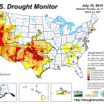
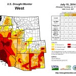
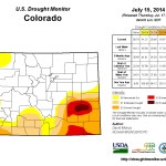
Click here to go to the US Drought Monitor website. Here’s an excerpt:
Summary
During the past 7-days, a series of slow-moving cold fronts traversed the eastern two-thirds of the Nation, triggering numerous and widespread showers and thunderstorms. Areas that recorded over 2 inches of rain for the week included portions of the central Plains, Midwest, Tennessee Valley, lower Delta, the Appalachians, most of Florida, the coastal Carolinas, and the mid-Atlantic. A northward surge of monsoonal moisture into the Southwest brought welcome rainfall to portions of the Four Corners States and Nevada, including more than 2 inches in southern and eastern Arizona, western New Mexico, and eastern Colorado. Unfortunately, hot and dry weather enveloped much of the Far West, including California. In the Northwest, temperatures averaged 8 to 12oF above normal with highs in the 90’s and 100’s, and numerous wild fires were reported. In Puerto Rico, scattered showers fell across the northern and eastern sections of the island, but dry weather prevailed in the southwest as D0 developed there. Scattered showers on Hawaii were enough to maintain conditions.
Southern and Central Plains
Similar to the middle Missouri Valley (e.g. Nebraska), southeastward moving thunderstorms dumped heavy rain (>2 inches) on swaths of central Kansas into eastern Oklahoma and western Arkansas, providing improvement where the greatest rains fell. In central Kansas, D2 replaced D3 as both short and medium-term (to 6-months) surpluses existed. In Oklahoma, D3 and D2 were improved by 1-category in the northeast, D2 was chipped away in central sections, and D0 was eliminated in eastern Oklahoma and western Arkansas. However, the southwestern section of Oklahoma observed dry and warm weather, justifying a small expansion of D2 there. In Texas, it was a relatively dry week, following a wet May and near-normal June. Accordingly, only small changes were made, with a slight reduction of D4 and D2 in the Panhandle, some trimming of the D0 along the western Gulf Coast, and slight downgrades in southwestern, south-central, and extreme south Texas. Although Oklahoma’s winter wheat crop was estimated to be the smallest since 1957 (51 million bushels) and its 17 bushels per acre yield matched 1967 (due to drought and freezes), summer row crops and pastures were rated much better, with the worst conditions in the west. Similarly, Texas crops were doing okay, with oats, cotton, and sorghum rated 28, 23, and 9% poor or very poor, respectively, and pastures and ranges at 22%, generally better off than the past several years.
Southwest and Great Basin
With much of California in either D3 or D4 and May-September normally dry, there is not much more room for further deterioration, at least during the dry season. With that said, however, further investigation of the long-term (36-month) deficits in southern California east of San Diego were similar to conditions to the north, along with overall impacts. Therefore, D3 was expanded east of San Diego to include the mountains, and to cities such as Riverside and San Bernardino. With June in the books, NCDC rankings for California for the July 2013-June 2014 period were the warmest and 3rd driest since 1895. The only drier July-June periods were in 1923-24 and 1976-77. This is the first time California experienced 3 consecutive years in the top 20 for dryness: 2011-12 ranked 20th, 2012-13 ranked 18th, and statewide precipitation has averaged 67% of normal during this 3-year period, and was just 56% of normal in 2013-14. Fortunately California’s reservoirs hold more water than they did in 1977 when the state experienced its 4th and 2nd driest years on record from July 1975-June 1977. However, a recent study estimated that this drought will cost California $2.2 billion in 2014, with a loss of over 17,000 agricultural jobs.
In contrast, a robust start to the July southwest monsoon was seen in parts of the Southwest. More than 2 inches of rain fell on central and southeastern Arizona, much of western and central New Mexico, and most of southern and eastern Colorado. Totals were much lower (<0.5 inches) in southwestern Arizona, southeastern California, most of Nevada and Utah, western Colorado, and southeastern New Mexico. Since this was the first wet week in Arizona, only small improvements were made where the largest rains fell (southern sections). In New Mexico and Colorado, wetter weather back in May and June, plus this week’s rains, allowed for larger and more significant 1-category improvements as both short and medium-term (to 180-days) surpluses existed, albeit somewhat tempered in New Mexico and southeastern Colorado by 2- and 3-year deficits. Fortunately, over 2 inches of rain fell on D4 areas of eastern Crowley, northeastern Otero, and northwestern Bent counties, improving conditions to D3 there, while just to the south, similar totals upgraded conditions from D3 to D2 (southern sections of Otero and Bent and northern Las Animas). Eastern Colorado and adjacent western Kansas also saw a 1-category improvement with additional rains this week. Elsewhere, status-quo prevailed.
Looking Ahead
During July 17-21, moderate to heavy rains are expected from the central Rockies southeastward to the lower Delta, and then into the Southeast during Days 6-7. Florida should also see moderate rains. The largest amounts (3 to 6 inches) for the 5-day period are forecast for the Red River Valley and eastward into Arkansas. The West will be seasonably dry, and the southwest monsoon is predicted to be quiet, with only light totals (<0.5 inches) in eastern Arizona and New Mexico. The northern Rockies and Plains, plus the Midwest, should be mostly dry. Subnormal temperatures are forecast for the West Coast and eastern half of the Nation, with above-normal readings expected in the Rockies and northern Plains.For the ensuing 5-day period, July 22-26, the odds favor above-median precipitation in the eastern half of the U.S., Pacific Northwest, and northern Alaska, with below-median rainfall likely in the Great Basin, Rockies, High Plains, and south Texas. Temperatures are expected to average below normal in the Pacific Northwest and Alaska, but likely to be above-median in the Southwest, Rockies, Plains, Great Lakes region, and New England.
EPA: Proposed rule to protect clean water — exclusions and exemptions for agriculture will not change
— U.S. EPA Water (@EPAwater) July 17, 2014
Fort Morgan kicks in another $45,000 for the Northern Integrated Supply Project

From The Fort Morgan Times (Dan Barker):
Fort Morgan City Council members unanimously approved an extra $45,000 for the Northern Integrated Supply Project at their regular meeting Tuesday night.
Many of the necessary reports and studies for the water project are nearly done, but that effort cost more than anticipated, said Brent Nation, water resources and utilities director for the city.
Fort Morgan had paid the project $90,000 earlier this year, which is essentially the dues for the project, but the Northern Colorado Water Conservancy District asked for an adjustment to the dues to pay for the studies that have been done recently, he said.
The city of Fort Morgan has a 9 percent share of the project, which will come to about 3,600 acre feet of water the city could tap when the NISP reservoirs are completed, Nation said…
Altogether, NISP is expected to cost $500 million, Nation said, and Fort Morgan’s share would cost $40 million.
Once the supplemental draft environmental impact statement is done, which could be soon, NISP will begin thinking about starting construction, said Fort Morgan City Manager Jeff Wells…
Once the environmental impact report is published, there will be a period of public review and public meetings, Nation said.
There are those who are opposed to the project, and they will come out to say so, he said. However, this will also be an opportunity for supporters to say why they want NISP.
Nation said it is encouraging to be at this point in the project after 10 years of work.
Wells said Fort Morgan has spent about $1.2 million on the project over the past 10 years…
McAlister noted that there are a number of municipalities on the plains that have serious water supply problems, and Fort Morgan must do something or it could have similar problems.
More Northern Integrated Supply Project coverage here and here.
We must make sure Weld County’s voice is heard in water planning effort — The Greeley Tribune #COWaterPlan
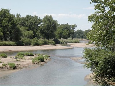
The Greeley Tribune editorial staff weighs in on the Colorado Water Plan:
We know that readers’ eyes tend to gloss over when we write about water issues in northern Colorado. One almost needs to go through four years of law school, with an emphasis on water law, to truly understand the complicated system that provides water throughout our state.
But we would strongly suggest that readers should pay attention to the South Platte Basin Roundtable, which is a group of water officials and experts who meet regularly to address water issues and plan for the water future of northeastern Colorado.
We won’t blame you for being bored by the topic. But the truth is, the availability of water — or the lack thereof — probably will have more to do with the future of our region than any other issue.
The South Platte water plan is part of a statewide effort, coordinated by the Colorado Water Conservation Board, which is piecing together the South Platte Roundtables plans with seven other roundtables around the state, to create a comprehensive water plan by the end of 2015.
The South Platte Roundtable’s work outlines how agriculture, cities and industries can coexist in the future. The plan for northeastern Colorado is nearing completion, and probably will be released to the public by late July.
Once the draft plan is released, the Colorado Conservation Board wants the public’s input. That should be our cue to pay attention and participate.
The South Platte Basin includes six of the state’s 10 top ag-producing counties, including Weld County, which ranks ninth nationally for its value of production. Three of the other top 10 are also in northeast Colorado in the nearby Republican River Basin, which is impacted by South Platte basin functions.
Also, eight of the 10 largest cities in Colorado are in the South Platte basin, including Denver and Aurora. That’s why the South Platte and Metro roundtables are combining their implementation plans.
Because of that, and continued growth along the northern Front Range and in the metro Denver area, the South Platte basin faces the biggest expected water shortages in the state.
“With each basin having its own interests and each facing its respective challenges, it’s going to be a Herculean effort … to bring all of these together without something getting lost,” said Eric Wilkinson, general manager of the Northern Colorado Water Conservancy District in Berthoud, which oversees the largest water-delivery system in northern Colorado and is working to put in place more water-storage projects. “Each basin has put in a lot of time and thought into their plans, and to see something get lost along the way going forward would be tough for any of us.”
If you only pay attention to one water discussion this summer, make sure this is the one.
We must make sure our eyes are clear and are voices are loud to help shape the future of Greeley, Weld County and northern Colorado in a real and direct way.
More Colorado Water Plan coverage here.
USGS Celebrates 50th Anniversary of Water Resources Research Act
USGS Celebrates 50th Anniversary of Water Resources Research Act http://t.co/VMscwSYaxW #USGSnews
— USGS (@USGS) July 17, 2014
Roaring Fork watershed: Robert Woods was named the 2014 River Conservator Award at River Rendezvous last week
Robert Woods was named the 2014 River Conservator Award at River Rendezvous last week. http://t.co/S9mTTyJO5F
— RoaringFkConservancy (@rfconservancy) July 16, 2014
Georgetown: Meter replacement project nearly complete
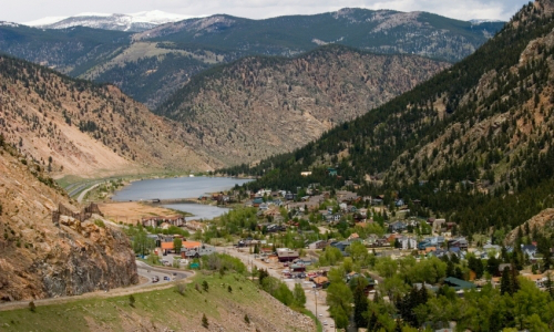
From the Clear Creek Courant (Beth Potter):
Georgetown is about to complete its water-meter replacement program, and rather than asking homeowners to foot the $550 installation bill, the town took out a loan and got a grant to cover the cost. The town is replacing 660 meters because they were not accurately recording how much water homeowners were using. The town board discussed the issue for two years, trying to determine the best way to foot the cost.
The town received a $170,000 grant in 2013 from the state Department of Local Affairs and has taken out a loan for $211,000 from the Colorado Water Conservation Board to pay the rest of the cost. The loan is for 30 years at 4.1 percent interest, according to town administrator Tom Hale.
Residents will repay the debt through increases to their water bills, though Hale is unsure how much the increase will be. The $211,000 loan is part of a larger amount the town has borrowed to pay for renovations to the Georgetown Lake dam. He expects water rates to reflect the entire loan repayment in 2016.
Georgetown mayor Craig Abrahamson said having residents pay for the new water meters through small increases in their water bills would be “an easier pill to swallow” for most people.
The town hired a company from Utah to replace the meters, which will allow a meter reader to drive down the street to collect meter data.
The primary purpose of replacing the meters, Abrahamson said, is to improve their accuracy and help the town better assess how much water residents actually use.
More than 87 percent of Georgetown’s 597 water users needed new meters. The radio-read meters cost $400, and installation costs $150. The remaining 75 were installed within the last couple of years and don’t need to be replaced.
Based on readings from the new meters, the town may determine whether it can lower water rates.
More infrastructure coverage here.
On this day in 1922, construction began at Grand Coulee Dam as the first shovel of dirt was turned
#Onthisday in 1933, construction began at Grand Coulee Dam as the first shovel of dirt was turned. pic.twitter.com/FBwZYtvxIF
— Reclamation (@usbr) July 16, 2014