Colorado transmountain diversions via the State Engineer’s office
Here’s a report about last week’s Colorado Foundation for Water Education transbasin diversion tour from the Water Quality and Quantity Blog. Here’s an excerpt:
Because QQ works to address environmental (and resulting economic) impacts from transmountain diversions, the best part of the tour for me was gaining a better appreciation for how interconnected the State is through transmountain diversions.
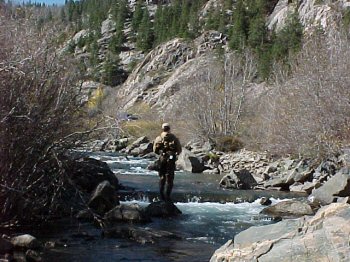
The Arkansas Valley is the recipient of water that is diverted through complex tunnel systems, or simple diversion ditches, from the western side of the Continental Divide to water population centers on the Front Range. The tour focused primarily on the benefits that historic transmountain diversions (TMDs) have provided to the Eastern Slope. Chaffee County Commissioner Dennis Giese even thanked the West Slope for the water that makes their recreation and ranching economies thrive (a touching gesture that does not happen enough in dialogue across the divide).
We saw the first-ever TMD, the Ewing Ditch, and walked along the ¾ mile ditch from the diversion point to the point it crosses the Continental Divide. We saw TMDs of a much larger scale too, watching water blast from the side of a mountain, bringing water from Homestake Reservoir in the Eagle River basin through a 5-mile tunnel to Turquoise Reservoir and the Arkansas River basin.
More Colorado Foundation for Water Education coverage here.
Releases from Crystal Dam will be reduced from 1450 cfs to 1350 cfs on Tuesday, September 30th at 9:00 AM. The Uncompahgre Valley Water Users Association will be reducing diversions into the Gunnison Tunnel by 100 cfs on Tuesday morning. Flows in the lower Gunnison River are currently above the baseflow target of 1050 cfs. River flows have remained relatively high due to the September rains and flows are expected to stay above the September baseflow target at the new rate of release.
Pursuant to the Aspinall Unit Operations Record of Decision (ROD), the base-flow target in the lower Gunnison River, as measured at the Whitewater gage, is 1050 cfs for September through December.
Currently, diversions into the Gunnison Tunnel are around 1050 cfs and flows in the Gunnison River through the Black Canyon are around 450 cfs. After this release change Gunnison Tunnel diversions will be around 950 cfs and flows in the Gunnison River through the Black Canyon should still be around 450 cfs. Current flow information is obtained from provisional data that may undergo revision subsequent to review.
Representatives from several government agencies, including the EPA, informed La Plata and San Juan county commissioners last week that the Red and Bonita mine will be plugged to help stem the flow of metals.
“This is a worthwhile investment,” said Steve Way, on-scene coordinator for the EPA.
The EPA plans to pay for the large concrete bulkhead, which could cost between $750,000 and $1.5 million, Way said earlier this year.
The Red and Bonita Mine is a major source of metals such as cadmium, zinc, iron and aluminum that have been flowing into Cement Creek and are responsible for killing off native fish and other species, the researches told local commissioners.
“We really need to do something about this before it gets worse,” said John Ott, general manager of Animas Water Co.
While his well water is in good shape, as a farmer on the Animas River below Bakers Bridge, he said he is disturbed by the pollution.
In 2003, the Sunnyside Gold Corp., the last major mining operation in Silverton, stopped treating the water in Cement Creek.
Then in 2006, the Red and Bonita started leaking high levels of metals after the American Tunnel was plugged in several places, which raised the water table, said Peter Butler, co-coordinator of the Animas River Stakeholders Group.
In recent years, the EPA and other agencies have come together to assess if plugging the mine would significantly reduce pollution. They found it contributes some of the highest levels of heavy metals year-round to Cement Creek and leaks about 300 gallons of polluted water per minute, Way said. A plug would help, but it would not eliminate all the seeping metals.
The mine was active for only a few years in the late 1800s, and miners carved out only 2,000 feet of tunnels below the surface that the EPA and the Colorado Division of Reclamation, Mining and Safety could explore in 2013. After mapping the mine, scientists don’t believe the tunnels are connected to any other systems where polluted water could find an outlet.
The scientists also reason that the bulkhead could reduce the amount of pollution any potential water-treatment plant would have to process if one is installed. The Animas River Stakeholders Group has been researching treatment plant options, but it could be very expensive to maintain.
“Treating water, that is a forever decision,” Way said.
However, a valve will be built into the bulkhead, so that if it causes problems, it could be opened back up. To what degree the plug may raise the water table and how the water would be dispersed is unknown, Way said.
While this would be an EPA project, it will not require Superfund listing. It would be a short-term project by a different branch of the agency.
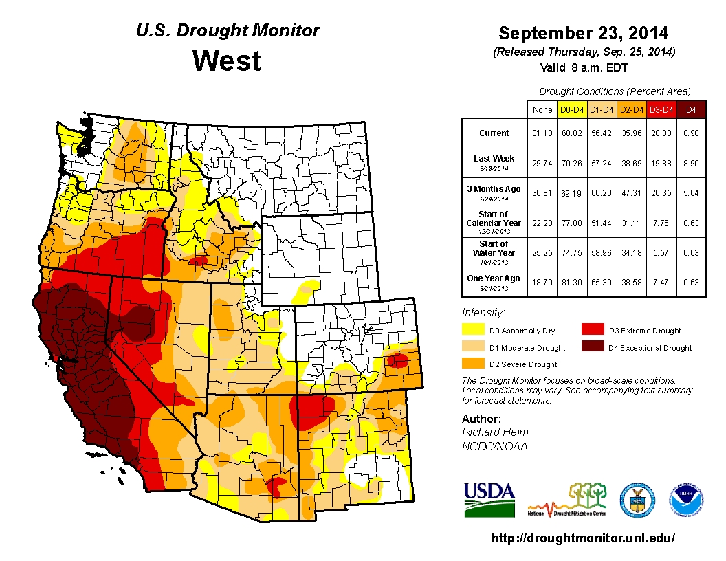
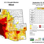
West Drought Monitor September 23, 3014 From the Cortez Journal (Jim Trotter):
The 2014 water year is ending gently – for Colorado, at least – as monsoonal rains and the remnants of Hurricane Odile provided enough moisture to push even the drought-stricken southeastern quadrant of the state into the 70-90 percent of normal precipitation range…
The 2014 water year is ending gently – for Colorado, at least – as monsoonal rains and the remnants of Hurricane Odile provided enough moisture to push even the drought-stricken southeastern quadrant of the state into the 70-90 percent of normal precipitation range.
It’s reasonable to think of it almost as an escape, as the state was cool and wet enough to avoid the massive wildfires of the previous two years, Black Forest in 2013 and Waldo Canyon and High Park in 2012, which claimed a total of more than 1,100 homes. There was no epic September flood this time around.
In comparison to California, which continues in the throes of devastating drought, and parts of Washington and Oregon, where millions of acres burned this water year, Colorado was downright fortunate.
“Water year” is a Western term, and the new one begins Oct. 1. It has to do with the annual cycle that includes the first snow in the high country, the accumulation of the snowpack, the spring melt and runoff, the warm summer and whatever rain might fall.
That makes today, Sept. 30, New Year’s Eve of the 2015 water year. But one can forgive residents of southeastern Colorado if they’re not breaking out the party hats. While the late rains boosted moisture totals there toward respectability, the region has been locked in various stages of damaging drought for years.
The U.S. Drought Monitor map, a product of the Department of Agriculture that is updated weekly, has five levels of dryness, from D0, abnormally dry, to D4, exceptional drought. Along with the Texas and Oklahoma panhandles, a big chunk of northeastern New Mexico and southwestern Kansas, southeastern Colorado has been firmly fixed with D3s, extreme drought, and D4s, as bad as it gets.
The modern map, in fact, has looked very similar to that of the Dust Bowl of the 1930s, even though, as of now, it has moderated a bit.
“Absolutely,” said assistant state climatologist Wendy Ryan from her office in Fort Collins. “As we were keeping track, particularly in 2011 and 2012, we started drawing comparisons to the ‘30s. It was as dry and as hot down there as the Dust Bowl.”
The visual elements were also there: Enormous dust storms, but not with the frequency or longevity of the 1930s, and tumbleweed melees that covered highways and buried barns and houses…
The lower Arkansas River basin has a long way to go before recovery to normal, Ryan said. The late season moisture has allowed farmers there to get a start on winter wheat, an endeavor that hasn’t panned out in the recent drought years. The big word is evapotranspiration, which is the soil losing moisture with no rain, and through plant transpiration, or “plant sweat.”[…]
The Four Corners were also dry this water year, as was the San Juan River basin, and the Rio Grande has been drought-plagued – which pretty much accounts for the southern tier of Colorado.
In the northern half of the state, the picture for this closing water year has been dramatically different.
The upper Colorado River basin has been flush, and beginning after last September’s massive floods, conditions along the South Platte basin have been extraordinary. Winter wheat yields on the northeastern plains were bountiful, conditions there “beautiful,” as Ryan described them.
A look at the “teacup” map published weekly by the Colorado Climate Center at Colorado State University also tells the story. Lake Granby is 128 percent of average for this time of year, 98 percent full. Blue Mesa is 74 percent full, Lake Dillon is 99 percent full. Green Mountain is at 85 percent.
All of this munificence is a matter of scale, of course. Downstream on the Colorado River, massive Lake Powell was only 51 percent full last week, and, on the other end of the Grand Canyon, giant Lake Mead has been losing water after years of drought like someone pulled the plug.
Unrelated to the Colorado River but very related to water in the West is the map published last week by the California Department of Water Resources depicting water levels in the Golden State’s major reservoirs, which ranged from 12 to 39 percent full.
Click here to download the report (Herring, S. C., M. P. Hoerling, T. C. Peterson, and P. A. Stott, Eds., 2014: Explaining Extreme Events of 2013 from a Climate Perspective. Bull. Amer. Meteor. Soc., 95 (9), S1–S96.) Here’s the abstract:
Attribution of extreme events is a challenging science and one that is currently undergoing considerable evolu- tion. In this paper, 20 different research groups explored the causes of 16 different events that occurred in 2013. The findings indicate that human-caused climate change greatly increased the risk for the extreme heat waves assessed in this report. How human influence affected other types of events such as droughts, heavy rain events, and storms was less clear, indicating that natural variability likely played a much larger role in these extremes. Multiple groups chose to look at both the Australian heat waves and the California drought, providing an opportunity to compare and contrast the strengths and weak- nesses of various methodologies. There was considerable agreement about the role anthropogenic climate change played in the events between the different assessments. This year three analyses were of severe storms and none found an anthropogenic signal. However, attribution assessments of these types of events pose unique challenges due to the often limited observational record. When human-influence for an event is not identified with the scientific tools available to us today, this means that if there is a human contribution, it cannot be distinguished from natural climate variability…
5. NORTHEAST COLORADO EXTREME RAINS INTERPRETED IN A CLIMATE CHANGE CONTEXT
Introduction. Welcome rains over northeast Colo- rado starting on 9 September 2013 turned into a deluge during 11 September and continued through 15 September. Boulder, an epicenter of this regional event (http://www.crh.noaa.gov /bou/?n=stormtotals_092013), almost doubled its daily rainfall record (from 12.2 cm in July 1919 to 23.1 cm on 12 September 2013), with 43.6 cm for the week. Widespread flooding took 10 lives and caused at least $2 billion in property damage, second only to the June 1965 floods of eastern Colorado (http://www.reuters.com/article/2013/09/19/us-usa-colorado-flooding-idUSBRE98H1BA20130919).
Events of similar magnitude are not unprecedented during summer in the Colorado Front Range (Hansen et al. 1978; McKee and Doesken 1997). Some reach that size in a few hours and are more localized (e.g., Big Thompson in late July 1976), while others take longer and have larger footprints as in June 1965 and September 1938. Interestingly, attributes of the 2013 event, including its late-summer occurrence, regional scale, long duration, and slowly changing atmospheric circulation (see Gochis et al. 2014, manuscript submitted to Bull. Amer. Meteor. Soc.) that transported extreme moisture into the Front Range, also characterized the 1938 event.
Does the recent occurrence of this extreme event indicate that its likelihood has increased due to global warming? Globally, the atmosphere has become warmer and moister, with the observed rate of increase since the 1970s broadly consistent with that expected from the Clausius–Clapeyron relation (~7% per °C; Hartmann et al. 2014). Heavy precipitation events have increased over much of the United States since 1901, however, with no sig- nificant long-term trends over the northern Great Plains or Southwest (Kunkel et al. 2013). Further, the relationship between heavy precipitation and atmospheric water vapor varies seasonally, with moisture availability rather than moisture-holding capacity being a more dominant factor in summer than winter (Berg et al. 2009). Thus, the answer to our question cannot be readily gleaned from globally and annually averaged statistics but requires careful consideration of place and time…
Conclusion. Our analysis of the GEOS-5 simulations leads to a diagnosis that the occurrence of extreme five-day rainfall over northeast Colorado during September 2013 was not made more likely, or more intense, by the effects of climate change. From an observational perspective, analogous events have occurred before in the Front Range, perhaps most strikingly similar in September 1938, long before appreciable climate change.
Although our model results suggest that the occurrence of this recent extreme has become less probable over northeast Colorado due to climate change, model projections do show an increase in the intensity of maximum five-day precipitation over the globe and for annual averages as a whole by the end of the 21st century (Sillman et al. 2013). Yet, a slight decline in intensity of the maximum five-day precipitation over the central Great Plains during summer is also projected (Sillman et al. 2013), emphasizing that global and annual perspectives of climate change may not always pertain to events at a specific place and time.
A strength of our study is the availability of an ensemble of long-term climate simulations spanning 1871–2013, conducted at 1° spatial resolution, that permits an analysis of statistical properties of the change in extreme events. For the purpose of study- ing regional five-day rainfall events over northeast Colorado, the GEOS-5 model has the attribute of re- alistically characterizing the tails of the distribution. A weakness of our study is that results are based on a single model and thus require confirmation using additional models. Also, the physical reasons for the decline in simulated frequency of extreme five-day rainfall over northeast Colorado during September are not addressed. Better understanding of the deliv- ery mechanisms for atmospheric moisture that pro- duce heavy rain events and how those mechanisms respond to global warming will be critical.
…climate change may have had little to do with those extreme rains, and global warming could reduce the likelihood that they’ll happen again, according to a new study, which is disputed by one of the nation’s most prominent climatologists.
The new study, published Monday in a supplement to the Bulletin of the American Meteorological Society (BAMS) analyzing climate change’s role in extreme weather events across the globe in 2013, uses a single computer model to reach its conclusion and says the results have yet to be confirmed by other models.
Using a computer model called GEOS-5, the study concludes climate change made last September’s rains neither more likely nor more intense. Similar events have occurred in the past before human-caused climate change was a factor in any region’s weather, the study says…
He said the local geography, where the Great Plains end abruptly at the point where the Rocky Mountains rear skyward out of the prairie near Boulder, lends itself to greater precipitation due to the orographic effect. The orographic effect is the way landscape topography, mountains in Colorado’s case, affects local weather.
Hoerling cautioned that more research needs to be done to confirm his team’s findings, and the study should not be viewed as the final word on climate change’s role in the Colorado floods.
“We don’t have a lot of answers,” he said. “It raises more questions.”
One critic of the study, which was announced with a news release under the headline, “Climate Change Not to Blame for 2013 Colorado Floods,” didn’t mince words after it was published.
“There is no justification for the headline of the news release at all, and the study has little relevance to the flood in Colorado in September 2013,” said National Center for Atmospheric Research senior scientist Kevin Trenberth, who is also based in Boulder. “They ask the wrong questions, do the wrong analysis with inadequate tools and come up with the wrong answer.”
In any extreme rainfall event, the weather situation is always the main player in how such a storm develops, but says nothing about the role of climate change, Trenberth said in a written statement.
“They do note the importance of having abundant moisture in the region in order to produce high enough rainfall amounts,” he said. “But they fail to analyze where the moisture comes from.”
Water vapor above Denver hit a record during the rains at the same time as sea surface temperatures south of Baja California, Mexico, were briefly 30°C, about 1°C warmer than normal, making it the hottest spot for the ocean in the Western hemisphere, Trenberth said.
“An incredible 75 mm of moisture was recorded in the atmosphere in that region by NASA satellites,” Trenberth said in his statement.
High sea surface temperatures (SSTs) led to the large-scale convergence of moisture into the region, and it was siphoned north by a very unusual pattern in the atmosphere creating a large river of moisture flowing straight toward Colorado, he said.
“I think there is no doubt that those extremely high SSTs and record water vapor amounts likely would not have occurred without climate change,” Trenberth said. “This study is largely irrelevant; it misses the big picture and gets the wrong answer.”
Hoerling said the study’s model accounted for high sea surface tempertures in the Pacific, the river of moisture flowing toward the state and other factors. He said he is perplexed as to why Trenberth was unaware of that.
“I’m confident that other experiments will repeat the experiments we published in this BAMS report, and those will help reveal if the indications from the first such effort are robust or not,” Hoerling said.
Colorado State Climatologist Nolan Doesken told Climate Central that the study’s conclusions do not surprise him.
“Maybe it will be more obvious in 35 years, but from a 2014 vantage point here in our part of the country, changes in temperatures on a seasonally and annually averaged time frame do show a trend; precipitation probably does not, and the extreme tail of the precipitation distribution — the really big ones — are just too few and far between here to yet get much of a handle on,” Doesken said.
Giant floods and extreme rain happened in the same region at least twice in the 20th century, so it’s hard to peg climate change on something that has ample precedent in the area, and even harder to associate local extreme events to an increase in global greenhouse gas emissions, he said.
The question of how flood control projects on Fountain Creek can be built without harming water rights will be taken up next month in the heart of farm country.
The Fountain Creek Watershed Flood Control and Greenway District will host the first of a series of meetings to discuss the issue during the winter water meeting set for Oct. 17 at Otero Junior College in La Junta.
The winter water meeting will be hosted by the Southeastern Colorado Water Conservancy District and will bring together some of the largest ditch companies east of Pueblo.
The group determines how a court-decreed program that allows farmers to store water in Lake Pueblo or ditch company reservoirs outside the growing season will operate.
That’s similar to the issue at hand on Fountain Creek, where flood control dams have been proposed, primarily to protect property in Pueblo.
At the July meeting of the Arkansas Basin Roundtable, a grant that proposed to look at the feasibility of Fountain Creek dams was rejected out of hand because several farmers objected to altering water rights to accommodate the dams.
They argued that junior water rights would be injured by such storage.
The timed release of water at more useful times in programs such as the winter water program could actually enhance water rights, however. Some have said this is possible with flood control dams.
In fact, the Denver Urban Drainage District is attempting to work through the same issue, Executive Director Larry Small told the board.
“We need to make it clear we have no intention of harming anyone’s water rights,” Pueblo County Commissioner Terry Hart said.
Several other meetings are planned by the Fountain Creek district to determine if flood control can be done in a way that keeps junior rights whole.
Meanwhile, the district is starting to prioritize spending prior to Colorado Springs’ $50 million payment as part of the Southern Delivery System. Here’s a report from Chris Woodka writing for The Pueblo Chieftain:
A district formed to improve Fountain Creek wants to start planning how it will use $50 million in funding that will begin arriving when the Southern Delivery System pipeline comes on line.
“We have to get an idea of what our priorities are before a dime arrives,” said Pueblo County Commissioner Terry Hart, a member of the Fountain Creek Watershed Flood Control and Greenway District board.
The $50 million will be paid to the district over five years by Colorado Springs Utilities as part of its 1041 agreement with Pueblo County. The money is for building flood control projects that primarily benefit Pueblo, such as a dam or series of dams.
SDS is projected to be fully permitted and online as soon as 2016, so the checks could begin coming in early 2017.
The district does not want to be put in a position of having to directly spend the money, but wants to use it to leverage funding from other sources.
“The projects identified so far exceed $100 million,” Hart said. “There could be even more as we branch out of the core area. We need to find the best ways to leverage other grants.”
Hart asked the board to form a committee specifically to look at how the money would be spent. It would include representatives from Pueblo County, the district and Utilities.
That conversation comes even as the district watches the progress of a stormwater vote in El Paso County this November and sets its budget for next year.
The vote will determine whether Colorado Springs and its neighbors will agree to fund stormwater improvements to the tune of $39 million annually beginning in 2016. That would satisfy other requirements of the 1041 agreement.
The district also is looking at whether its own budget could be paid with advance interest payments from Colorado Springs Utilities or if it’s time to pass the hat again among member governments.
At the meeting, Hart noted that the district is relying heavily on voluntary contributions and must start looking at its real operating costs if it is to become sustainable.
Finally, water quality is a concern and responsibility on Fountain Creek as well. Here’s a report from Chris Woodka writing for The Pueblo Chieftain:
While the focus lately has been on reining in water on Fountain Creek, the quality of that water is important too.
“We have a statutory duty to clean up the Fountain Creek watershed,” said Pueblo County Commissioner Terry Hart Friday at the meeting of the Fountain Creek Watershed Flood Control and Greenway District. “There are significant problems that we still don’t know enough about.”
So the board caught up on the science of water quality from Del Nimmo and Scott Herrmann, who have spent years studying water quality on Fountain Creek, the Arkansas River and Lake Pueblo.
The three are interconnected, Nimmo explained.
“We have tremendous resources and they are all connected,” Nimmo said. “They are tied to the reservoir.”
Lesson 1: Invasive species in Lake Pueblo will have more opportunity to spread to Fountain Creek and reservoirs in Pueblo County when the Southern Delivery System pipeline is completed, Herrmann explained.
Lesson 2: Mercury has accumulated in the water and fish in the headwater areas of Fountain Creek and Monument Creek, where the scientists did not expect to find it. Nimmo’s theory is that emissions from power plants or from former smelters in both Pueblo and El Paso counties contributed to this, but that’s not been proved. He suggested the district think in terms of an “airshed” as well as a watershed.
Lesson 3: The researchers have baseline data about water quality prior to the large, destructive Waldo Canyon and Black Forest fires. They also collected samples of the charcoal-laden water after the first big rainfall following the Waldo Canyon Fire in 2012.
“This study needs to be repeated about now, in the next year, to see what effect the fire had,” Herrmann said.
Nimmo and Herrmann have headed up numerous Fountain Creek studies at Colorado State University-Pueblo over the past decade. Herrmann has studied aquatic life in Lake Pueblo since its construction in the early 1970s. Nimmo was involved in other studies on the Upper Arkansas River near Leadville as well.
“We need to continue this type of study,” Hart said. “It should be a district project.”
Puebloans have been stingy with water this year, and it’s likely going to cost the Board of Water Works.
“We’re going to be 3 percent short in water use,” said Seth Clayton, director of administrative services for the water board.
Pueblo is on pace to use less than 8 billion gallons, down about 250 million gallons from projections.
The reason was a cool, wet, early summer that reduced the need for outdoor watering. On the hottest summer days, it’s not unusual for the peak pumping in Pueblo to hit 50 million gallons per day.
This year, the peak came on June 30, when 46.5 million gallons were pumped. Part of the reason for lower pumping totals has been reduced use in city parks, which receive water at no cost.
“September has been better with the warm weather,” Clayton said.
The average household will use about 113,000 gallons this year, which is down from 117,000 gallons last year and the average of 127,000 gallons from 2004-14.
Treated water sales are expected to fall $1.68 million below projections, but will be offset by $1 million in raw water leases, Clayton added.
“Overall, we will be about $800,000 short on revenue, but we’ll make up most of that on reduced expenditures,” Clayton said.
Total revenues for the water board were projected to be $34.48 million at the beginning of this year.
A high desert thunderstorm lights up the sky behind Glen Canyon Dam — Photo USBR
From the Associated Press (Terry Tang) via The Denver Post:
U.S. Interior Secretary Sally Jewell and other officials marked the 50th anniversary of power generation by Glen Canyon Dam, a structure that helped usher in a new era in the Southwest.
Glen Canyon Dam, situated near the Arizona-Utah border, is a source of water and power for seven states in a region prone to drought.
Jewell told the crowd that the dam is not without its controversy but was an engineering feat that was economically valuable to the future of the country. It’s a key part of the Colorado River Storage Project.
Since the 1960s, the structure in Page, Arizona, has blocked 90 percent of the sediment from the river from flowing downstream, turning the once muddy and warm river into a cool, clear environment that helped speed the extinction of fish species and endangered others.
Here’s the release from the US Bureau of Reclamation (Matthew Allen):
Today [September 27], at a ceremony on the crest of Glen Canyon Dam, Secretary of the Interior Sally Jewell joined other officials and dignitaries to kick off a celebration marking the 50th anniversary of power generation at Glen Canyon Dam.
“At the 50th anniversary of Glen Canyon Dam, we are not just standing at crest of this dam – we are standing at a crest of history in the West,” Secretary Jewell said. “Glen Canyon Dam harnessed the power of the Colorado River to open the West to millions of people by providing for their water and power needs. Today we celebrate the triumphs and sacrifices of the people and communities that made this immense undertaking possible.”
Secretary Jewell thanked the people and the community who have supported Glen Canyon from the early days of construction and the continuation of operations today including Facility Manager Jason Tucker, who oversees the operation of the dam for the Bureau of Reclamation and Todd Brindle, Superintendent of Glen Canyon National Recreation Area. She also praised Assistant Secretary of Water and Science Anne Castle, who is leaving Interior at the end of the month for new ventures, for her outstanding work with Reclamation, National Park Service and other Interior agencies on adaptive management of the Colorado River Basin.
In addition to Secretary Jewell, other guest speakers included, Assistant Secretary Anne Castle, Mayor of Page Bill Diak, Colorado Energy Distribution Association Executive Director Leslie James, as well as Former President of the Colorado Water Users Association Ron Thompson.
“The Colorado River has always been known for its superlatives – the most volatile supplies, the most iconic landscapes, the most dammed, the most litigated, and recently, the most threatened,” remarked Assistant Secretary Castle. “Collectively, we need to make this river, this basin, this economy, one that will endure into the future and ensure that our children and grandchildren will be able to enjoy the same benefits and gifts that this river has provided to all of us. Operation of Glen Canyon Dam that is based on sound science and that balances a complex set of interests has been and will continue to be key to that sustainable future.”
Glen Canyon Dam is a key unit of one of the most extensive and complex river resource developments in the world, providing vital water storage and power generation for the west. It allows the Upper Colorado River Basin States of Colorado, New Mexico, Utah and Wyoming to utilize their share of the Colorado River while providing the required delivery of water to the lower basin states of Arizona, California and Nevada.
Situated on the Colorado River in northern Arizona, near Page, Glen Canyon Dam is the second highest concrete-arch dam in the United States—710 feet above bedrock, second only to Hoover Dam, which stands at 726 feet. The structure impounds Lake Powell, the second largest man-made reservoir in the United States. The powerplant began generating clean, renewable hydropower on September 4, 1964. The inexpensive electricity generated by this facility contributes to the renewable energy footprint in the western United States and has contributed to the modernization of hydroelectric power that exists today and will continue into tomorrow.
Today Lake Powell can store nearly two years of the Colorado River’s average annual flow, helping mitigate the current drought; moreover, the powerplant produces 5 billion kilowatt hours of hydroelectric power each year – enough electricity to help supply the power needs for 5.8 million customers. It would take 2.5 million tons of coal or 11 million barrels of oil to generate the same amount of hydropower that Glen Canyon provides every year using clean, renewable hydropower. The many hundreds of miles of shoreline at Lake Powell provide opportunities for hiking, camping, swimming, boating and fishing. Glen Canyon Dam and the adjacent Carl B. Hayden Visitor Center annually host nearly one million people on guided tours.
“Glen Canyon Dam, its Powerplant and Lake Powell are critical components of Reclamation’s Colorado River Storage Project,” said Lowell Pimley, Acting Commissioner for the Bureau of Reclamation. “We are proud that this facility has and will continue to generate clean renewable hydropower, regulate the flow of the Colorado River, store water for multiple beneficial uses, help reclaim arid and semi-arid lands, provide flood protection and offer prime recreation opportunities to millions of Americans.”
The celebration continued after the ceremony with tours of the dam and powerplant, an antique car show, several displays related to power generation and water use from federal, state, and local partners. A special presentation by the Navajo tribe allowed visitors to see traditional Navajo dance. Additionally, at the event a video was premiered that was created by local Page High School students in collaboration with Reclamation titled, “I am Glen Canyon.”
For more information on the event or on Glen Canyon Dam and Powerplant, please contact Reclamations Upper Colorado Regional Public Affairs Officer Matthew Allen at 801-524-3774 or mrallen at usbr.gov.
The water in Navajo Reservoir could play a role in meeting Colorado River Compact obligations in the event of continued drought, said Bruce Whitehead, director of the Southwestern Water Conservation District.
Release of water to Lake Powell from Navajo Reservoir, Flaming Gorge Reservoir on the Green River in Utah and Blue Mesa Reservoir on the Gunnison River is one of three measures his district and the Colorado River District want implemented if water storage in the network that supplies seven Western states approaches crisis level, Whitehead said.
The other measures call for increasing the amount of water available and, lastly, reducing use.
“We’re not in crisis now,” Whitehead said. “The 2013-2014 water year has been almost normal as far as the amount of water in Lake Powell.
“But the reality is that in spite of some good water years, we’re in a 15-year drought,” Whitehead said. “We need a plan to meet a crisis if the same conditions continue.”
The three measures to meet a critical water shortage came out of a recent meeting of Southwestern and the Colorado River District, which between them cover the Western Slope.
The recommendations went to the Upper Colorado River Commission, which regulates water matters in Colorado, Wyoming, Utah and New Mexico, the Upper Basin states that supply Arizona, Nevada and California, the Lower Basin states…
The concern about Lake Powell is that if water drops below the level needed to generate electricity, federal agencies would lose $120 million a year in power sales.
The revenue from power sales funds among other things environmental programs such as protecting fish species in the San Juan River, Whitehead said.
If the water level in Lake Powell allows generation of power, there should be enough water to satisfy the 1922 Colorado River Compact, Whitehead said.
Again, Whitehead said, Lake Powell and Lake Mead aren’t at critical levels. But the Upper Colorado River Commission and counterparts in Lower Basin states are looking at what-if situations.
Thus, the recommendations from his district and the Colorado River District, Whitehead said…
Measures to increase the amount of water available through cloud seeding, removal of water-hungry nonnative vegetation such tamarisk and Russian olive and evaporation-containment methods are a first step, Whitehead said.
A second early step, Whitehead said, would be the release to Lake Powell of water from Navajo, Blue Mesa and Flaming Gorge reservoirs which, respectively, have acre-feet capacities of 1.7 million, 829,500 and 3.79 million.
The contributions of Navajo and Blue Mesa could be less than optimal because of contractual obligations, Whitehead said. Blue Mesa also generates electricity.
If the first two steps aren’t enough, water users would be affected directly, Whitehead said. The consumption of cities and agricultural users would be reduced. Fallowing of fields also could be required.
The two commissions said if water for agriculture is reduced, the loss must be shared by Colorado River water users on the Front Range.
Front Range users receive 500,000 to 600,000 acre-feet of water a year from Colorado River transmountain diversions, Whitehead said.
Another transmountain diversion sends 90,000 to 100,000 acre-feet a year to the San Juan/Chama Project from the Blanco and Navajo rivers, Whitehead said. Users in Santa Fe and Albuquerque benefit.
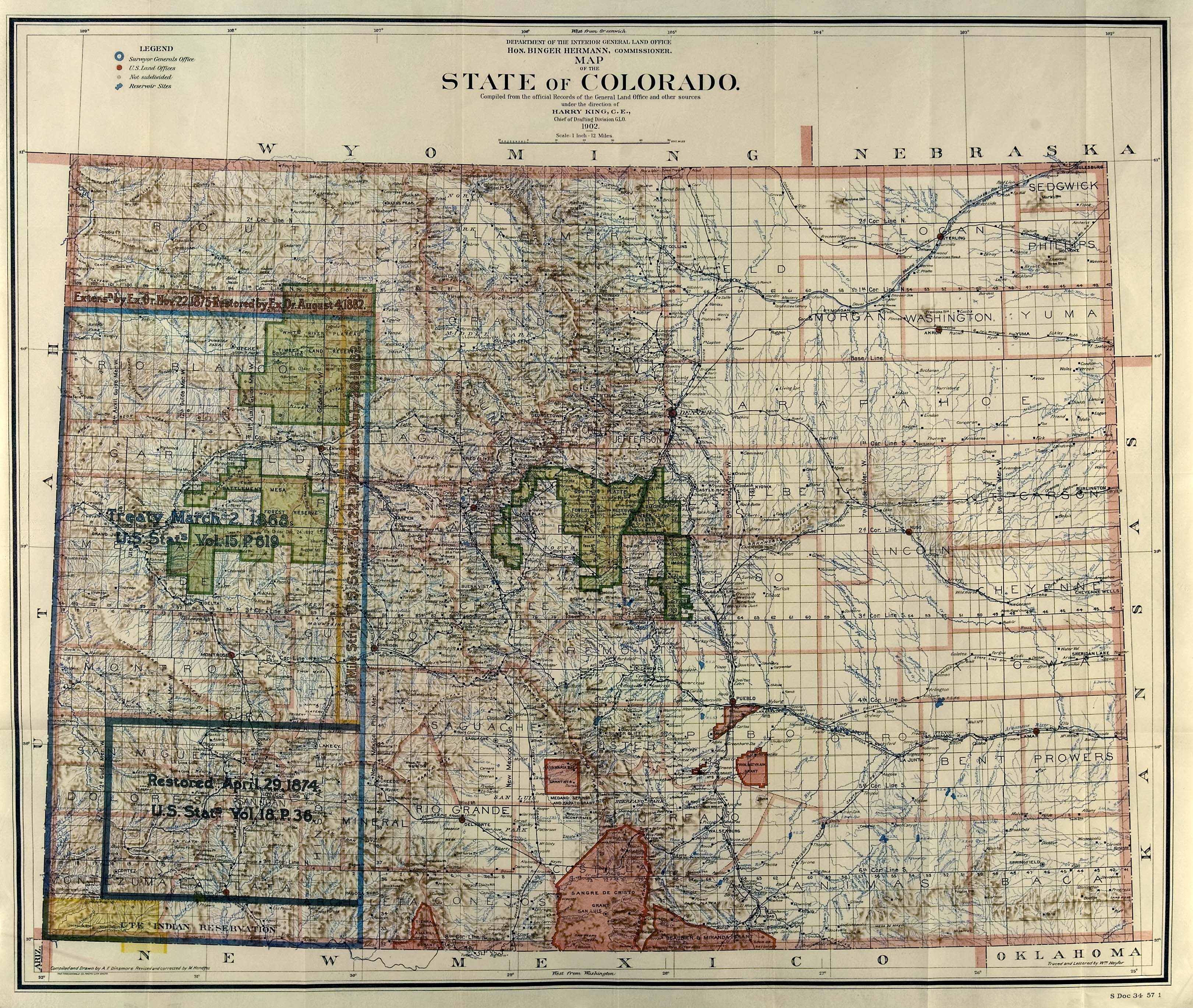
Colorado Supreme Court Justice Gregory Hobbs’ favorite tool for teaching about the history of water law in Colorado is the Land Office Map of 1902. All of the forces at play that shaped Colorado’s water-scape today are there to see, from Indian reservations to homesteads to growing cities and vast forested watersheds out of which plummet the headwaters of great rivers that flow on journeys toward the sea.
Some pink blobby areas near the bottom of the map signify the Mexican Land Grants. The Treaty of Guadalupe Hidalgo required the United States to recognize the rights of the settlers on those lands – including their age-old water rights.
The town of San Luis, one of the oldest communities in Colorado, lies within one of these pink blobs in the heart of the Sangre De Cristo Grant. And here, at the south end of town, Hobbs said reverently, “You can see the 1852 People’s Ditch.”
San Luis People’s Ditch via The Pueblo Chieftain
Serving the village of San Luis de la Culebra before Colorado was even a territory, let along a state, the People’s Ditch began as a hand-dug irrigation channel and was later widened by oxen pulling a plow. It was one of many acequias (gravity-fed ditches) in the San Luis Valley, allowing agriculture to flourish through a water-sharing network originally based on equitable allocation, rather than priority.
This “beautiful ditch” that delivers water from the west side of the towering Sangre de Cristo range to the dry lands of the San Luis Valley holds a special place in Hobbs’ heart. That’s because it holds the very first adjudicated water rights in Colorado – rights that Hobbs has been sworn to uphold through his role as a Colorado Supreme Court Justice.
The People’s Ditch still serves water users today, irrigating approximately 2100 acres of hay and other row crops.
It was only one stop in Hobbs’ romp through Colorado’s water history and law, delivered as a keynote address at the Annual Water 101 Seminar hosted in Telluride on Monday, Sept. 21. The annual seminar is an outreach program coordinated by the Durango-based Water Information Program.
Other stops along the way ranged from an ancient (long dried-up) ditch-fed reservoir near Mesa Verde that is believed to be one of the oldest water supply structures in North America (“This just proves the Mormons and miners invented water law,” Hobbs quipped); to utopian agricultural communities along the Poudre River where the doctrine of public ownership subject to allocation for beneficial use (basically “We were here first – put the water back!”) was first hashed out; to Glorieta Pass in northern New Mexico, where in 1862 a ragtag bunch of Colorado farmers and miners “made the Texans go back to Texas.”
This decisive western battle of the Civil War thwarted the dreams of a Confederate stronghold in the southwest, and paved the path for continued settlement of the region under Union terms via the Railroad Act, Homestead Act, and various land grants.
It all fits into Hobbs’ intricate and nuanced understanding of the complexities of Colorado water law, which evolved alongside the evolution of Colorado as a territory carved out of surrounding states, “to hold against confederates the whole area where gold might be found.”
While Colorado’s headwaters, along with its gold, are high in the mountains, the roots of its system of prior appropriation and the beneficial use of water can be traced to the Eastern Plains, Hobbs said.
Simply put, the system evolved out of the need of Front Range farmers to have the assurance they could raise crops on intermittently arid lands to feed the miners and residents of growing cities, on a landscape where water must be conveyed great distances via rivers and ditches across other peoples’ property, to reach one’s crops.
Thus, as irrigators in an arid land, the foundation of Colorado’s water law is the right to cross intervening private and public lands to build a ditch to get water where you need it, “because if an intervening land owner could block your ditch you could not perfect a water use right,” Hobbs explained.
As Hobbs wrote in his “Colorado Water Law Summary,” the water provisions of the state’s 1876 Constitution laid out four key principals that are still in place today, that together comprise the Prior Appropriation Doctrine:
All surface and groundwater within Colorado is owned by the public and dedicated to the use of the people through water rights established as prescribed by laws of Colorado and the United States;
Court decrees and groundwater permits enforced by state water officials define the right of water use for a wide variety of agricultural, municipal, commercial, recreational and instream flow purposes (together described as “beneficial uses”);
Water users paying just compensation may obtain a right-of-way across the lands of others for the construction and operation of needed diversion, conveyance and storage structures;
The streams and aquifers can be used to transport and store water without interference by riparian landowners.
“It’s a doctrine of scarcity, not of plenty,” Hobbs said, and it has held up well over the years, largely thanks to Colorado’s groundbreaking 1881 legislation that set up an administrative and judicial system to enforce priority rights.
Hobbs will be turning 70 this December, and is retiring from the court in Aug. 2015. As a Colo. Supreme Court Justice, he has fully embraced his role as final arbiter in water disputes, which in Colorado bypass the Court of Appeals and ascend straight from the state’s seven water courts to the Supreme Court level…
Greg Hobbs, Dick Bratton, Jim Pokrandt
A poet, author and historian who has taught water history and culture throughout the country as well as in the Netherlands and France, Hobbs is particularly well-versed in the bipolar nature of Colorado, and its “80 percent problem” – stemming from the fact that 80 percent of Colorado’s water is on the Western Slope, and (almost) 80 percent of its population on the Front Range.
Adding to the complexity of this problem, Colorado’s waters spill off the Continental Divide and flow to the Gulf of Mexico and (sometimes) the Sea of Cortez, with 19 states including Colorado dependent upon this snowmelt.
Nine interstate compacts ensure equitable apportionment of water among the states that share the system; Colorado is only permitted to consume about one third of the water that arises in the state and must ensure that the remainder stays in the rivers for downstate water users.
These compacts will be tested in the years to come, with the predicted gap between demand and supply, and some states like California already in crisis.
The Colorado River District held its annual seminar on Friday [September 18] at Two Rivers Convention Center to discuss water issues concerning the Colorado River Basin.
Each year, there is a certain topic of discussion at the seminar involving development plans or water-allocation. This year, District leaders and speakers focused on agriculture efficiency and conservation when it comes to water. Some of the challenges that are facing agriculture water users include climate change and drought.
The Colorado River District encourages the public and representatives to voice their opinions and get involved with them. They say it’s important to talk about the water in the Colorado River Basin and its use, priorities, and development.
From the Glenwood Springs Post Independent (Amy Hadden Marsh):
What would the Colorado River and Roaring Fork valleys look like without the ranches and farms? That question has been haunting me ever since I attended the Colorado River District’s water seminar in Grand Junction last week. Close to 300 people listened to speakers Brad Udall, of the Colorado Water Institute, Jeff Lukas, lead author of a report about how climate change could effect water management in the state, CSU’s Perry Cabot, Aaron Citron of the Environmental Defense Fund (EDF), Mark Harris of the Grand Valley Water Users Association and author Kevin Fedarko.
Agriculture is a large part of life on the West Slope. But, it’s not just about bucolic landscapes; it’s also about what goes on behind the scenery – the rural lifestyle and economy that depend on agriculture to survive as well as a healthy, natural environment that supports animals, plants, and humans.
So, what could make West Slope farms and ranches disappear? No water. Or, at least, not enough water, which is what experts from all sectors agree could very well be Colorado’s future.
Here’s the numbers part. The Colorado River serves about 40 million people right now. But, that won’t always be the case. Two years ago, the Bureau of Reclamation issued the Colorado River Basin Water Supply and Demand Study, which predicted a population increase anywhere from 9.3 million to 36.5 million people within the Colorado River Basin. That means the amount of people living in the seven basin states could almost double within the next four decades. As a result, says the study, we could be short 3.2 million acre-feet of water…
…does that mean farmers and ranchers have to give up their livelihoods and thereby cause a domino effect around the rural West in order to satisfy Front Range urban needs?[…]
Basically, the answer was “no” but, according to most of the speakers, that doesn’t mean ag folks and Front Range municipal water users should stand on their respective ends of the tug ‘o war rope, arms akimbo, refusing to budge. “Efficiency” and “conservation” were the buzzwords of the day, meaning everyone basically needs to use less water. That’s sort of a no-brainer but the real conundrum is getting everyone to agree on what that looks like.
EDF’s Aaron Citron writes a sort of ag blog for the organization’s website and he said he thought people would laugh at the idea. When I asked him why, he said that in the West, environmentalists are seen as anti-agriculture or anti-growth. But, he added, that is changing. And, it’s all because of water.
“As we talk about the future of water in the West,” he said, “there really is an important alignment between agriculture who want to keep water in place and tend to be some of the best stewards of the land and environmentalists and conservationists who also want to see the protection of open space and who want to keep water in place.”
In other words, environmentalists and ranchers can be friends. And, in terms of the West’s water future, they have to be…
Solutions at this point are experimental and include new irrigation techniques and incentives to use them, and efficiency technology like smart ditches and soil monitoring. But, what it comes down to is education, open-mindedness (particularly about climate change), agreement, and respect.
More Colorado River Water Conservancy District coverage here.
Arkansas River Basin — Graphic via the Colorado Geological Survey
Here’s the release from the USGS (Kenneth R. Watts, Tamara Ivahnenko, Robert W. Stogner, James F. Bruce):
By 2030, the population of the Arkansas Headwaters Region, which includes all of Chaffee and Lake Counties and parts of Custer, Fremont, and Park Counties, Colorado, is forecast to increase about 73 percent. As the region’s population increases, it is anticipated that groundwater will be used to meet much of the increased demand. In September 2009, the U.S. Geological Survey, in cooperation with the Upper Arkansas Water Conservancy District and with support from the Colorado Water Conservation Board; Chaffee, Custer, and Fremont Counties; Buena Vista, Cañon City, Poncha Springs, and Salida; and Round Mountain Water and Sanitation District, began a 3-year study of groundwater and surface-water conditions in the Buena Vista-Salida Basin. This report presents results from the study of the Buena Vista-Salida Basin including synoptic gain-loss measurements and water budgets of Cottonwood, Chalk, and Browns Creeks, changes in groundwater storage, estimates of specific yield, transmissivity and hydraulic conductivity from aquifer tests and slug tests, an evaluation of areas with potential for underground water storage, and estimates of stream-accretion response-time factors for hypothetical recharge and selected streams in the basin.
The four synoptic measurements of flow of Cottonwood, Chalk, and Browns Creeks, suggest quantifiable groundwater gains and losses in selected segments in all three perennial streams. The synoptic measurements of flow of Cottonwood and Browns Creeks suggest a seasonal variability, where positive later-irrigation season values in these creeks suggest groundwater discharge, possibly as infiltrated irrigation water. The overall sum of gains and losses on Chalk Creek does not indicate a seasonal variability but indicates a gaining stream in April and August/September. Gains and losses in the measured upper segments of Chalk Creek likely are affected by the Chalk Cliffs Rearing Unit (fish hatchery).
Monthly water budgets were estimated for selected segments of five perennial streams (Cottonwood, North Cottonwood, Chalk, and Browns Creeks, and South Arkansas River) in the Buena Vista-Salida Basin for calendar year 2011. Differences between reported diversions and estimated crop irrigation requirements were used to estimate groundwater recharge in the areas irrigated by water supplied from the diversions. The amount of groundwater recharge in all the basins varied monthly; however, the greatest amount of recharge was during June and July for Cottonwood, North Cottonwood, and Chalk Creeks and South Arkansas River. The greatest amount of recharge in 2011 in Browns Creek occurred in July and August. The large seasonal fluctuations of groundwater near irrigated areas in the Buena Vista-Salida Basin indicate that the increased groundwater storage resulting from infiltration of surface-water diversions has dissipated by the following spring.
Areas within the Buena Vista-Salida Basin with the potential for underground storage were identified using geographic information system data, including topographic, geologic, and hydrologic data, excluding the mountainous areas that border the Buena Vista-Salida Basin and igneous and metamorphic rock outcrop areas. The areas that met the selection criteria for underground water storage are located on terrace deposits near the Arkansas River and adjacent to its major tributaries. The selected areas also contain much of the irrigated land within the basin; consequently, irrigation ditches and canals could provide a means of conveying water to potential recharge sites.
In the summer of 2013, the group of partners put heavy machinery in the creek and began the project, which is expected to take four summers and cost about $800,000.
Due to a lack of initial funding, the project was broken into two parts and shortened from a goal of 3,200 feet of creek restoration to about 2,750 feet.
Project partners completed phase one of the project last week. So far, they’ve restored about 1,600 feet of stream channel and 3.15 acres of riparian, wetland and floodplain habitat.
On Sept. 12 the partners received a $275,000 grant from the Colorado Water Conservation Board for phase two.
Thanks to that grant funding, Anderson said, the project has almost reached its fundraising goal and work will continue.
The state water conservation board has provided most of the money for the project. Climax contributed $80,000 to the first phase and $50,000 to the second, Copper Mountain paid for the Forest Service environmental assessment and some materials, and the National Forest Foundation and CDOT are pitching in.
This summer, the group planted around 3,000 shrubs, Anderson said. The town of Frisco provided 2,200 willow clippings from a site near Whole Foods, which a Forest Service crew clipped in the early spring and volunteers with the Friends of the Dillon Ranger District planted in June. Then another 800 shrubs came from a nursery.
The revegetation has seen an 80 percent success rate so far with the willow transplants, said Jim Shaw, board treasurer of the Blue River Watershed Group, which he credits to “a wonderfully wet summer.”
That wet summer created some hurdles though. Runoff season lasted longer than usual, and high flows eroded the creek for two weeks, damaging the revegetated area in two places.
The heavy runoff gave some insight into how the creek will flood in future years, Shaw said, so last week the partners fixed up some of the damaged spots but they will probably keep one part the way it is now.
Next summer, the partners will start phase two and work toward restoring another 1,200 feet of the creek downstream toward the Conoco gas station.
When the project is finished, the creek will have improved habitat for fish, birds and other creatures. For the humans spending time in and around the Tenmile, that means better wildlife watching, fishing and kayaking.
“Having natural ecosystems that function at their potential, be they streams or lakes or forests,” Anderson said, “all these things, they’re important to the quality of life in Summit County.”
Significant portions of the Ogallala Aquifer, one of the largest bodies of water in the United States, are at risk of drying up if it continues to be drained at its current rate. Courtesy of MSU
Ogallala aquifer via USGS
Ogallala aquifer boundaries
Here’s the blog post from the US Department of Agriculture:
James Pike has tackled an important and thorny issue in Laramie County, Wyoming – water conservation. More specifically, this district conservationist with USDA’s Natural Resources Conservation Service (NRCS) has diligently worked to encourage farmers and ranchers in the region that is fed by the Ogallala Aquifer to use water wisely.
Stretching from western Texas to South Dakota, the Ogallala Aquifer supports nearly one-fifth of the wheat, corn, cotton and cattle produced in the United States. Underlying about 225,000 square miles of the Great Plains, water from the aquifer is vital to agricultural, cities and industry, making up 30 percent of all groundwater used for irrigation in America.
NRCS’ Ogallala Aquifer Initiative aims to reduce aquifer water use, improve water quality and enhance the economic viability of croplands and rangelands in Colorado, Kansas, Oklahoma, Nebraska, New Mexico, Texas, South Dakota and Wyoming.
Too many wells combined with inefficient irrigation have made water conservation a volatile topic in Wyoming.
The result of Pike’s hard work for Wyoming so far: 1 trillion gallons of water saved annually or 3,000-acre feet. To put acre feet into perspective, in the United States, one acre foot of water is used by a suburban family of five each year.
The former Agricultural Water Enhancement Program, or AWEP, provides farmers like Mike Poelma, who grows wheat on 125 acres, with financial incentives to not use underground water source for crops – only rainwater.
Poelma hopes his one irrigation well and two smaller wells will eventually recharge with water. But he knows it’s not an easy fix and will take some time.
Additionally, AWEP also provides financial assistance for practices for better efficient water use. The program has helped save energy that would have gone to growing marginal crops. From 2010 to 2014, NRCS invested about $2 million through the program in Laramie County.
The 2014 Farm Bill has many other programs are available to landowners who want to help conserve water, including the Environmental Quality Incentives Program, which is the program that now funds NRCS’ Ogallala Aquifer Initiative.
This initiative in the eight states saved enough water during fiscal 2010 and 2011 to provide water for over 53,000 families or 265,000 people.
Laura Spann from the Southwestern Water Conservation District in Durango announced yesterday the release of The Southwest Basin Implementation Plan (BIP), which can be found under the “community” tab on the Colorado Water Plan website http://www.coloradowaterplan.com.
The local portion of the state plan can be accessed by clicking on “San Juan and Dolores River Basin” under the community tab. The resulting page states, “Residents and interested parties are encouraged to participate in the Basin Implementation Plan process. As the process moves forward, documents relating to the plan will be posted here.” There are currently two documents on the page available for download.
While the website allows for electronic comments to be made concerning the broader Colorado Water Plan, Spann asks that interested members of the public direct any comments specifically about the southwest portion of the plan to Carrie Lile via email at carrie@durangowater.com or phone, 259-5322…
The website goes on to explain, “The Southwest Basin is located in the southwest corner of Colorado and covers an area of approximately 10,169 square miles. The largest cities within the basin are Durango (pop. 15,213) and Cortez (pop. 8,328). The region also includes three ski areas: Telluride, Wolf Creek and Durango Mountain Resort.”
The website concludes, “The Southwest Basin is projected to increase in municipal and industrial (M&I) water demand between 17,000 acre feet (AF) and 27,000 AF by 2050 with passive conservation included.”
Matt Clark, director for the Dolores River Chapter of Trout Unlimited, is organizing a project to install a fish passage and improved diversion dam at the Redburn Ranch north of Dolores.
Currently, landowners have to build a cobble push-up dam across a wide section of river every year to get enough draw into a nearby diversion that irrigates the pastures.
The make-shift dam blocks fish from moving up and down the river and washes out every year at high flows.
“During the nine months out of the year it is up, there is no water flowing over it, preventing fish passage,” said Clark. “Plus it is a pain for the landowner to maintain.”
The solution is to build three, large-rock dams 200 feet apart that step down.
“Each one drops down the river a foot and has a pour-over,” Clark explained. “A side benefit is that it forms pools and ripple-habitat structure in between.”
In addition a new head-gate will be installed for the irrigation diversion.
Clark said there is anecdotal evidence that juvenile fish are getting trapped in that area of the river.
“A health trout fishery requires a connected river system,” he said. “When fish spawn higher up in the system, their larvae drift down and need to spread out without obstructions.”
The project is expected to be installed next fall, with cost estimates between $200,000 and $300,000. The Redburn Ranch fish passage project has been awarded a $50,000 grant from the Southwest Basin Roundtable, and $98,000 from the Colorado Water Conservation board. Trout Unlimited contributed $20,000, and the landowner contributed money as well, Clark said.
“We’re piecing it together,” Clark said. “It is a win-win for ranch management and fish habitat. Plus the pour-overs allow for easier passage for recreational boat passage.”
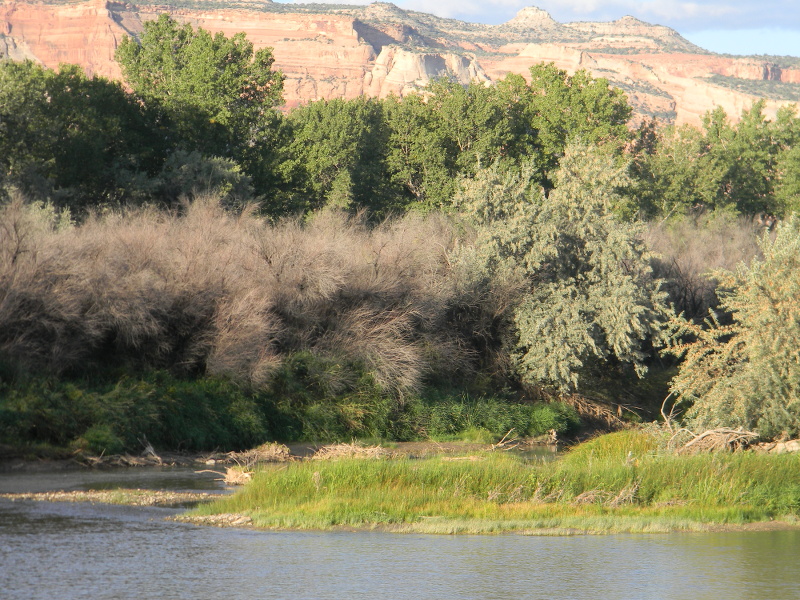
Meanwhile on the Lower Dolores River below McPhee dam, The Nature Conservancy is committed to improving riparian habitat by eradicating invasive tamarisk and planting native species.
TNC, along with the Southwest Conservation Corp, and the BLM formed the Dolores River Restoration Partnership. So far the effort has created 175 jobs and restored 821 acres.
“The impact of tamarisk is huge — they rob waterways of their health and make recreational access cumbersome,” says Peter Mueller, director of the Conservancy’s North San Juan Mountain Program in Colorado.
But, he adds, “When you get rid of this wicked tree, all of a sudden you can see the light, and you can see the river again.”
Aiding the effort is the spread of the tamarisk beetle, introduced into the West in the 1990s as a biological control agent. The U.S. Department of Agriculture imported tamarisk beetles from Eurasia, where they keep tamarisk in check, and after years of quarantine and testing, released them in Utah, Wyoming and Colorado.
“These beetles are one of the most tested biological agents we have and there’s little risk of them harming other plants,” says Mueller.
Over the last three years, the beetles have defoliated a majority of the tamarisk on a 60-mile reach of the Colorado River. From the release site in Utah, the insects have now moved into Colorado and the Dolores River watershed.
The lower Dolores is a more difficult river to tame because damming has altered its flow and flood timing, a condition that favors tamarisk and other exotic species.
“Restoring the health of the Dolores will require not only tamarisk removal, but improved water management and planting of native species,” Mueller said.
Native willow, sumac, and cottonwoods are planted, and native grass seeds are spread around where tamarisk once dominated.
From the Fountain Creek Watershed Flood Control and Greenway District via The Pueblo Chieftain:
HERE’S A chance for you to pitch in and get your hands dirty for the sake of cleanliness. Creek Week kicks off tomorrow and runs through Oct. 5 in Pueblo and El Paso counties. The coordinated event is intended to clean the banks along litter-clogged Fountain Creek.
So really, it’s another way to keep water — our most precious natural resource — clean.
That’s because trash that makes its way into the creek has been known to degrade water quality, harm wildlife, create safety hazards and clog irrigation and drainage structures.
The Fountain Creek Watershed Flood Control and Greenway District, along with more than 20 volunteer, governmental and nonprofit partners, is encouraging concerned residents to get involved. Volunteers of all ages are welcome, although the district website warns that children under the age of 18 must have at least one supervising adult with them.
Colorado River Basin including out of basin demands — Graphic/USBR From the districts via the Glenwood Springs Post Independent:
The two water conservation districts that comprise the entire Colorado River basin in Colorado have adopted principles concerning how extended drought conditions should be addressed on the river’s storage system.
Their recommended contingency steps, if needed, to boost extremely low levels at lakes Powell and Mead include releasing water from other reservoirs to Lake Powell, removing non-native trees and employing winter cloud seeding.
As drought conditions persist in the Colorado River basin, low water levels in the lakes are of extreme concern.
The seven Colorado River basin states and the Bureau of Reclamation are working on what is being referred to as a contingency plan to avoid the unacceptable consequences if the current basinwide drought continues.
At Lake Powell the concern is that storage could drop below the elevation necessary to produce power. If this occurs, federal agencies would lose up to $120 million per year in power revenues. These revenues are used to cover the operation of power-generating units and the transmission grid, repay the federal treasury for the facilities, and cover the costs of critical environmental recovery programs. Additionally, customers of federal power could see their costs skyrocket, as the Western Area Power Administration would have to go to the spot market to replace the lost hydropower.
The Colorado River and Southwestern water conservation districts met in a special joint meeting Sept. 18 in Montrose.
The boards resolved that changes in federal reservoir operations and additional investment in river augmentation programs must be the first priority.
If it becomes necessary to implement the contingency plan, stored water in Flaming Gorge, Navajo and the Aspinall Unit (Blue Mesa Reservoir) should be released and subsequently stored in Lake Powell to increase Powell’s lake levels, the boards said. Weather modification (winter cloud seeding) and removal of non-native, riparian trees (tamarisk and Russian olive) should be undertaken to enhance both river flows and water levels in Lake Powell.
Only if those efforts prove insufficient should “demand management” proposals be pursued, because those efforts would disrupt traditional water uses. Demand management proposals include a reduction in consumption by municipal and irrigation users and voluntary deficit irrigation and temporary fallowing by agricultural users.
The two boards stressed the importance that any demand management effort include conservation by both municipal and agricultural water users, and that any agricultural water disruptions be shared by Colorado River water users on both the East and West slopes.
The entire Colorado River basin from the Rockies through the Lower Basin to Mexico is in at least the 15th year of a historic drought. Despite occasional above-average years, the 15-year trend is very dry. Lake Powell is about half full and Mead is below 40 percent full.
Click here to go to the US Drought Monitor website. Here’s an excerpt:
Summary
The long-wave circulation pattern, during this U.S. Drought Monitor (USDM) week, consisted of an upper-level ridge over the western United States and trough over the east. This continued the trend of well-above-normal temperatures in the West and below-normal temperatures in the Midwest to Northeast. Low pressure systems, moving in the jet stream flow, dragged cold fronts across the contiguous United States (CONUS), bringing areas of precipitation to the northern Rockies, Plains, Great Lakes, and Southeast. Moisture from the remnants of Hurricane Odile deluged parts of the Southwest and western Texas with flooding rains, while a cold front spread moisture across portions of central and eastern Texas. Some of Odile’s tropical moisture fed monsoon showers over the Intermountain Basin. However, large parts of the Far West, Great Plains, and CONUS east of the Mississippi River had a drier-than-normal week…
The Plains and Midwest
With cooler-than-normal temperatures and areas of precipitation, no change was made to the USDM depiction in the Midwest, although mounting precipitation deficits were becoming a concern in northeast Minnesota. A weather system, that dropped 2-4 inches of rain over southwest Missouri, resulted in contraction of D0 there. But 30- to 90-day precipitation deficits continued to mount further east, with low streams becoming evident, so D0 expanded in east central Missouri. No change was made to the USDM depiction over the central and northern Plains, even though the week was mostly drier than normal. Areas of above-normal rain fell across Kansas, but they had little impact on agricultural conditions, so no improvement was made to the USDM depiction. The extreme dryness of the 2012-2013 drought severely depleted soil moisture in the state. As noted by the Kansas State Climatologist’s office, surface water supplies have not recovered materially, with ponds having a quarter to a third of normal capacity, even in areas receiving above-normal precipitation. The USDA reported up to 55% of the topsoil and 64% of the subsoil short to very short of moisture in some western crop districts, with 23% of pasture and range conditions poor to very poor statewide. Even in the northeast district, where soil moisture conditions were “wettest”, 15% of topsoil and 32% of subsoil were still rated short to very short of moisture…
The West
The remnants of Hurricane Odile dropped 2 inches or more of rain along a path from southeast Arizona, across southern New Mexico, into western Texas this week, with locally 5 inches or more reported in many areas along with widespread flooding. A CoCoRaHS weather station near Carlsbad, New Mexico, reported 10.48 inches of rain during the week. Reservoirs along the Pecos River in southeast New Mexico were replenished by the Odile rainfall, including Brantley and Red Bluff. Significant improvement in the USDM depiction was made, with D1-D2 pulled back in southeast Arizona, D0-D3 pulled back in southern New Mexico, and much of southeast New Mexico now drought-free. However, the Odile rainfall, while beneficial, was not enough to eliminate 3+ years of drought in other parts of the state. A band of moderate drought (D1) remained from southwest to south central New Mexico, with an oval of severe drought (D2) in the southwest corner of the state. Areas to the north received very little to no rain from Odile. Another dry week added short-term dryness on top of long-term dryness, so D2-D3 was expanded in northwest New Mexico. USDA reports indicated that, on a statewide basis, soil moisture and pastures and rangeland improved in New Mexico, with the values decreasing to 52% of topsoil and 56% of subsoil short or very short of moisture and 32% of pasture and rangeland rated in poor to very poor condition.
Further to the north, beneficial rains improved D0-D3 in southwest Colorado and D0-D1 at the junction of Colorado, Wyoming, and Utah. But D0 expanded into northwest Montana and D1 expanded into the north central prairies and canyons of Idaho to reflect dryness which appeared as notable departures on the 30-day to 6-month Standardized Precipitation Index. Firefighting crews were fighting large wildfires in the northern Idaho D1 area. Monsoon showers dropped an additional inch or more of rain over parts of the intermountain basin, adding to the above-normal rainfall this area has received during the summer. D1-D2 were pulled back in southeast to east central Nevada to reflect the short-term gains made due to the monsoon/tropical moisture. Showers in parts of California dropped a few tenths of an inch of rain, but had little effect on drought conditions. Reservoir levels in the state continued to decline and groundwater wells continued to go dry. Record warm January-August temperatures across the West have intensified evapotranspiration and exacerbated drought conditions. With continued much-above-normal temperatures, the drought depiction across the rest of the West remained unchanged…
Looking Ahead
During the September 25-30 period, a large upper-level trough of low pressure will begin moving over the western CONUS from the Pacific. Temperatures will be warmer than normal for much of the country at the beginning of this period, but become cooler than normal in the West near the end of the period. The trough should bring precipitation to much of the West, with an inch or more expected from northern California to the Cascades of the Pacific Northwest, and an inch or more over much of the Northern Rockies. The precipitation is expected to miss southern California. Bands of frontal precipitation are likely in parts of the Plains and Midwest, in the Southeast, and along the Gulf of Mexico and Atlantic coasts, although the precipitation is forecast to miss large parts of the Plains to Midwest.
The upper-level pattern will slowly migrate to the east during October 1-8. The 6-10 day and 8-14 day outlooks indicate that the temperature pattern will be below normal in the West and above normal in the East, with above-normal temperatures eventually returning to the West Coast. The precipitation pattern should transition to drier than normal in the West and wetter than normal from the Rockies to the Great Lakes and Southeast as the weather-producing systems migrate eastward. An upper-level ridge over the eastern Pacific is expected to bring above-normal temperatures to Alaska, with wetter-than-normal conditions to the southern coastal locations and drier-than-normal conditions to the interior Alaskan locations.
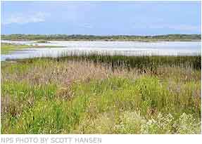
The most important resource at the Blanca Wetlands greets visitors the moment they get out of their cars. Mouths, ears, eyes and loose pant legs are all inviting targets for the bugs, which, more importantly, play a critical role in making the 10,000-acre wetlands a magnet for migrating shore birds and songbirds.
“That’s really our job, I think, out here, is to grow bugs,” Sue Swift-Miller, a wildlife biologist for the U.S. Bureau of Land Management, said.
Swift-Miller and fellow wildlife biologist Jill Lucero help oversee the wetlands, which sits 8 miles northeast of town, and manage the complex interplay of water management with the timing of bug hatches and bird migrations.
The bird species that come in the largest number include the Wilson’s Phalarope, Baird’s Sandpiper and the American Avocet.
But the wetlands and their bugs also attract species such as the western snowy plover, American white pelican, and the white-faced ibis. Those species and 10 others that visit the wetlands are designated as sensitive species by the agency, meaning they or their habitat are either in decline or projected to do so.
Overall, more than 163 mammals use the wetlands.
That the birds and the bugs are here in such numbers is the result of the BLM’s decision in the 1960s to restore the wetlands by drilling 43 wells into the confined aquifer, the deeper of the San Luis Valley’s two major groundwater bodies. The water, which averages out to roughly 5,000 acre-feet annually, is then funneled into a series of basins that range from fresh water ponds that support both cold- and warm-water fisheries to shallower basins that have a higher salt content than the ocean.
After years of study, Swift-Miller said it’s become evident that bugs need specific water-quality parameters, depending on the species. BLM officials can, with the help of hundreds of miles of canals and culverts, funnel fresh water to certain basins to dilute the salinity or withhold to emphasize it.
The intermittent use of water is particularly important in habitat areas known as playas, which are generally saline basins with clay dominated soils that historically went through wetting and drying cycles in the valley.
While drought and diversions for agriculture have cut wetting cycles, the BLM has found a jump in insects such as fairy and brine shrimp when it’s added water to the playas.
Macro Invertebrates via Little Pend Oreille Wildlife Refuge Water Quality Research
“We’re getting macroinvertibrates that have been in cyst stage for years,” Lucero said. “Nobody’s seen them for 50 years and suddenly they’re coming out as we wet an area.”
But choosing when to apply water is just as critical.
“If you’ve got bugs available when the birds aren’t here, you really haven’t done yourself any good,” Swift-Miller said.
The agency’s use of groundwater will soon be coming under a new set of state regulations, as is the case with all groundwater users in the valley. Those regulations, which remain in draft form, are expected to require groundwater users to obtain surface water to offset the injury their pumping causes to surface-water users.
But the BLM’s augmentation efforts began even before the draft regulations thanks to 20 illegal wells the agency drilled in the late 1970s.
While the agency will still have to get more augmentation water, SwiftMiller said it’s possible the agency will get enough to avoid shutting down any wells at the wetlands.
“I think we’re in pretty good shape for that,” she said.
Before the agency and other area water users began pumping groundwater, the Blanca Wetlands was the endpoint in a string of marshes, playas and lakes that extended to the north end of the valley. A map from 1869 shows the Blanca Wetlands as part of a large lake. Aerial photos from the 1940s in the agency’s possession show a string of connected wetlands that run to where the current San Luis Lake State Park sits, at the southwestern edge of the Great Sand Dunes National Park.
Earlier this year, the BLM approved a proposal that would allow it to buy property from willing landowners in an effort to expand the Blanca Wetlands and improve habitat connectivity. The search for willing sellers would focus on the area that extends north and northeast from the Blanca to the west side of the state park.
Another focus area for expansion sits further north on the western edge of Baca National Wildlife Refuge and runs east to Mishak Lakes.
While expansion funding would need to navigate the gridlock that has dominated congressional budget proceedings, the proposal did make it into the White House’s budget proposal for the 2015 fiscal year, which begins Wednesday.
From the Loveland Utilities Commission via the Loveland Reporter-Herald:
Loveland’s Utilities Commission will take a look Tuesday at an issue that has been pretty low on the city’s radar for the past 60 years: fluoridation of city water.
At a meeting slated for 4 p.m. at the Police and Courts Building, 810 E. 10th St., a pair of presentations is planned for commissioners: one seeking the reinstatement of fluoride additives to the city water supply at least to pre-2010 levels, and another seeking the removal of all fluoride.
Members of the public are encouraged to attend to learn more.
At issue is an apparent change in the city’s fluoridation process in the past few years, according to Larry Sarner of Loveland. In an interview Tuesday, he said that state-mandated reports in the past four years showed the city periodically discontinued fluoridation of the city’s water in 2010 because of maintenance at the treatment plant and didn’t resume them until 2013. However, when the city resumed fluoridating the city’s water, it was at about half of the level previous to 2010, Sarner said. According to city figures, only in the past couple of months has it returned to pre-2010 levels.
The dam at Northfield Reservoir, built back in 1890, is getting a $3.4 million facelift…
The Northfield Water System is part of a collection of 25 reservoirs that supplies water to Colorado Springs and other communities including Green Mountain Falls, Chipita Park, and Cascade. It is located in the rugged country between Woodland Park and the Air Force Academy. It was purchased by Colorado Springs Utilities for about $1.25 million in 1949. Today the system includes Rampart, Nichols, and Northfield Reservoirs.
Colorado Springs Utilities is making modifications and upgrades to the Northfield Dam to comply with state dam safety recommendations. The State Engineer’s Office currently classifies Northfield Dam as a small, significant hazard dam. The 124 year old structure is a 30 foot high, 350 foot long earth embankment with a storage volume of 245 acre feet of water. The spillway is an uncontrolled overflow concrete structure at the south end around 6 feet below the crest of the dam. A water treatment plant, just downstream of the dam, was retired from service in 1996.
The Northfield Dam Modification Project will be conducted by ASI Construction. They have three main tasks to complete. They will construct a new spillway with flow meters and a regulation gate and remove the old spillway. They will raise the height of the embankment by about 8 feet and provide new roads and grading downstream from the dam. Finally, they will demolish the old water treatment plant and associated structures. The work will include removal or abandonment of unused pipes, the inspection and possible replacement of the steel outlet pipe, and reclamation of the area after the end of construction.
Human fingerprints were not evident in the floods along Colorado’s Front Range in September 2013—at least not clearly.
“Because human changes have made the global atmosphere warmer and more moist, one can confidently state that all weather events are now subject to some influence of anthropogenic climate change,” says “Climate Change in Colorado.” A warmer atmosphere can hold more water, and the global atmosphere is estimated to have 3 to 5 percent more water as a result of anthropogenic, or human-caused, warming.
That alone “may have increased the source moisture for the event and increased the intensity of heavy rainfall,” the report adds.
But the weather pattern in September 2013 that dumped up to 18 inches of rainfall across portions of the Colorado foothills “was rare but not unprecedented, and climate change does not need to be involved to explain the pattern itself … The historical record strongly suggests that a flood event of the extent and magnitude of September 2013 could occur even in the absence of climate change.”
A report examining the link between anthropogenic warming and the 2013 floods is to be published by the Bulletin of the American Meteorological Society, but the conclusions there are not expected to conflict with these findings.
A steady stream of data collected at oil and natural gas sites in the Denver-Julesburg Basin flows into a server at CSU, where researchers use it to analyze groundwater quality.
Complex algorithms sift through the raw data, scanning for any anomalies or sudden shifts in water composition that could indicate contamination in a groundwater well. The data is analyzed and displayed as charts and graphs on a CSU website for the public to view, updated with new field data posted every hour.
The network of monitoring stations and website are part of the Colorado Water Watch, a project spearheaded by CSU researchers to provide the public with real-time information about water quality at oil and gas sites throughout the basin that underlies northeastern Colorado and the Nebraska Panhandle.
The CSU team is led by Ken Carlson, a professor of civil and environmental engineering, who believes it is the first monitoring system of its kind in the country.
“We don’t know of anyone else in the country who is collecting real-time data from groundwater wells next to oil and gas operations, evaluating potential changes with advanced anomaly detection algorithms and sharing it with the public,” Carlson said.
Water and energy
Carlson specializes in water quality research and over the years has narrowed his focus to the impacts of energy development on water. He leads the Center for Energy Water Sustainability, part of the Energy Institute at CSU.
In recent years, most of his work has centered on water and hydraulic fracturing.
Hydraulic fracturing or “fracking” is the practice of drilling deep wells – 6,000 to Colorado Water Watch infographic8,000 feet in the Denver-Julesburg Basin – into a layer of rock that contains oil and methane gas. A mixture of chemicals and water is injected to break up the rock and release the oil and gas that is then extracted.
Critics believe fracking is unsafe and, among other things, pollutes critical groundwater supplies.
Proponents defend the practice, saying there is no evidence hydraulic fracturing is releasing pollutants into groundwater supplies.
The topic has become increasingly controversial in Colorado and the nation.
“It’s gotten to the point people cannot have a civil conversation about it,” said Carlson. “Everyone produces studies that back up their beliefs. This could lead to confusion and some people may feel they do not have enough information to make informed decisions.”
Enter Colorado Water Watch, a real-time monitoring system to provide the public with easy-to-understand water quality information.
Gathering support
Carlson approached former Colorado Gov. Bill Ritter, who directs CSU’s Center for the New Energy Economy, about creating Colorado Water Watch during the 2012 Natural Gas Symposium.
Ritter liked the idea and from there, the two met with representatives from Noble Energy and the Colorado Department of Natural Resources, which oversees oil and gas issues in the state.
Both Noble and the state agency agreed to support the project and serve on the steering committee along with representatives from Western Resources Advocates, a conservation group; the Colorado Oil and Gas Conservation Commission; and the Colorado Oil and Gas Association industry group.
“One thing that makes this project unique is that we involved a variety of stakeholders in the project,” Ritter said. “We have approached this with a spirit of collaboration, and that has been highly beneficial to the project.”
Science Senator. It’s called science.
Based on science
Carlson and his research team have spent the bulk of the past 18 months developing the monitoring system using off-the-shelf sensors, identifying Noble-owned or -leased sites to install their equipment, and designing algorithms to crunch data coming in from the field.
The team has published several papers related to their work in peer-reviewed journals including Environmental Science and Technology and Journal of Applied Water Science.
“We wanted this to be based on sound, proven science,” Carlson said. “We’ve spent a lot of time working on that and validating the system and our results.”
Sensors and stations
So far, the CSU team, which includes Asma Hanif, research associate, and Jihee Son, a post-doctoral student, has installed four monitoring stations as part of the proof-of-concept phase of the project.
Three are located next to active oil and gas wells throughout the Denver-Julesburg Basin. The fourth is a control site at CSU’s Agricultural Research Development and Education Center – or ARDEC – near Wellington.
Each site has a sensor running down a well that collects water data and is connected via cable to a nearby data logger.
The sensors are placed at varying depths to collect information on various water sources. Some snake 40 feet down and monitor primarily groundwater that is vulnerable to spills or other surface activity. Others, such as the Galeton station, are placed 400 feet below ground to collect data on the Laramie-Fox Hills Aquifer, a confined aquifer that could be susceptible to leaks in oil and gas well casing.
Water flows around the sensors, which send information to the data logger every five seconds. That information is then relayed to CSU’s server via a wireless connection.
The system is designed to not only monitor water quality but also act as an early detection system. If it detects an anomaly or major change, Carlson and his team are immediately alerted.
They visit the site, take a water sample and send it to an Environmental Protection Agency-certified lab to be analyzed. With that information, they can identify the source of the contamination – even if it isn’t from oil and gas development.
“The system can detect changes in quality that could be due to any activity in the watershed including oil and gas operations, agriculture, other industrial activity and even urban runoff, Carlson said.
Providing more information
Until now, most of the publicly available water quality data has come from samples taken periodically by operators or regulators.
In Colorado, for example, water samples are collected at a proposed site before a well is drilled, a month after it is in operation, and then five years later. That information is available to the public upon request but is highly technical and can be hard for people to understand.
Information provided by the Colorado Water Watch project will help fill that gap, said Mike King, executive director of the Department of Natural Resources.
“There’s a tremendous amount of suspicion about government and about oil and gas development, and we thought that bringing CSU on and participating would provide that level of objectivity that many in the public felt was lacking,” King said.
Jon Golden-Dubois, executive director of Western Resources Advocates, supports Colorado Water Watch for similar reasons.
“Our interest is ensuring that more information is available and that a larger set of data is developed so that we can better understand the impacts of oil and gas development and fracking on water quality in Colorado,” he said.
The $1.2 million project has been extended beyond the proof-of-concept phase and additional monitoring wells will be installed this fall.
Carlson also would like to add an air quality component.
“If stakeholders – primarily the public and industry – find Colorado Water Watch valuable, the system could be extended for much of the oil and gas areas in the state and maybe beyond,” he said.
Homeowners and landowners have long expressed concerns about how the fracking process impacts water quality. Colorado regulations require water testing with a half mile of where a well is drilled. The samples are taken before and after the activity.
But what happens if water quality changes over time?
That question is what researchers at Colorado State University have been pondering. Their demonstration project, a partnership between CSU and Noble Energy, installed monitors at four sites in the Denver-Julesberg Basin near Greeley. In 2013, they began wirelessly transmitting data from the wells to researchers who are watching for changes.
Now CSU Engineering Associate Professor Ken Carlson said the data will be available for the public to review and monitor at Colorado Water Watch. It’s a step toward greater transparency, and believed to be the first of it kind when it comes to monitoring water quality near oil and gas sites.
“This isn’t an industry effort, this isn’t an environmental-group effort, we wanted it to be balanced, and we want the public to feel like they’re getting information that wasn’t filtered by either side,” Carlson said.
A year after the city was grappling with the potentially enormous cost of improving its aging stormwater system, the city has started to revamp its stormwater maintenance program without busting its budget or assessing property owners a new fee to help cover the cost.
The city also is earning kudos as it starts to adopt the recommendations of a much-praised citizen task force that spent more than 500 volunteer hours analyzing the city’s storm water infrastructure.
“We’ve historically maintained maybe a dozen culverts per year, and typically we’re just chasing problems and complaints,” Kelly Heaney, the city’s new water resources manager, said last week as she briefed the council on the improvements. “This year with the additional resources we were able to maintain 45 culverts in less than two months.”
Steamboat City Council members liked what they heard.
The biggest changes the city has made this year include hiring Heaney, increasing the streets maintenance budget and adding two seasonal employees dedicated to drainage maintenance.
All of the stormwater improvements in 2014 cost $302,000 and included $47,000 for capital improvements, according to Public Works Director Chuck Anderson.
The total cost of the improvements this year was far less than some of the multi-million dollar options the city was presented with last year for improving its neglected stormwater system.
Early last year, a Minnesota consulting firm that was paid $180,000 to study the city’s stormwater infrastructure, which includes bridges, culverts and dams, called for the city to possibly spend more than $10 million in new capital projects to upgrade its stormwater system and help manage future flooding and problems associated with annual spring runoff.
Faced with the high cost, city officials at one point floated the idea of assessing a fee to property owners to help pay for the improvements.
Before that, city officials were bracing for recommendations carrying a price tag even higher than the $10 million.
The city assembled the stormwater task force to look over the master plan and make recommendations for how to implement and fund it.
While several other communities in Colorado have turned to new fees on property owners to pay for expensive upgrades, the task force here recommended against that option at this time.
Instead, they called on the city to add more money in the annual budget for personnel to more proactively maintain the system.
Nathan Meeker was no stranger to the utopian society model when he issued “The Call” in The New York Tribune in December 1869.
He and his wife, Arvilla, had lived two years at the Trumbull Phalanx in Braceville, Ohio, which was based on the philosophical principles of Francois Fourier. These principles included the belief that everyone is entitled to a minimum income which would allow for a comfortable living, that prosperity is possible only through collective production, that every woman should be enabled to become economically independent, and that the unifying bond of community would be free, elective love, therefore abolishing the institution of monogamous marriage.
The Trumbull Phalanx, like many others established in the 1840s, was along a stream with fertile land for agriculture. The Phalanx was a self-sustaining commune where all the needs of the inhabitants were met within the structure of the colony itself. They grew their own food, cared for the children, had a library and other buildings and dwellings for the benefit of the members. The Meeker family lived at the Phalanx for several years, and Arvilla gave birth to their first born child, Ralph, while living there. Though Meeker saw the benefits to utopian living, there were some aspects of Fourier’s philosophy he just could not accept — namely free love and the rejection of monogamous marriage.
However, Meeker still believed there were some merits to the socialist utopian lifestyle. When he issued “The Call” he slightly modified Fourier’s ideas by placing a strong emphasis on the family structure, but he held on to many of Fourier’s other economic principles. For example, Fourier believed in the ownership of private property but also saw the need for a society to have common facilities to benefit the community. Meeker planned for the Union Colony to be divided into lots in town and outside of town. Each family would be apportioned a section outside of town for farming. Lots in town would be auctioned off, and the proceeds would be used to build a church, school and library. Meeker even envisioned a communal laundry and bakery for the Union Colony, but this idea never came to fruition.
Religion also played an important role in the colony. Unlike his contemporaries, Marx and Engels, Fourier believed that religion could actually be a benefit to society, and he encouraged the practice of organized religion. In “The Call” Meeker stressed the importance of family and religion by explaining, “In particular, should moral and religious sentiments prevail; for without these qualities, man is nothing.” At the same time, tolerance and liberality should also prevail. “One thing more is equally important: happiness, wealth and the glory of the state spring from the family, and it should be an aim and a high ambition to preserve the family …”
The Union Colony that Meeker eventually established attracted hard-working, temperate, family oriented people. The colony survived and prospered because it placed emphasis on working together for the benefit of all, particularly by supporting public education and culture, but still allowed for exceptionally hard working and innovative people to become prosperous in their own right.
For over a year, the proposed Hermosa Creek Watershed Protection Act has been celebrated as a beacon of bipartisanship, collaboration and consensus in an otherwise bleak landscape of mired Wilderness legislation.
The bill, HR 1839, has enjoyed strong bipartisan and bicameral support from its Colorado sponsors, Rep. Scott Tipton and Sen. Michael Bennet and their colleagues on both sides of the aisle.
But the version approved by the House Natural Resource Committee late last week contained amendments inserted by Tipton at the eleventh hour that weaken some of the bill’s environmental protections, several stakeholders have alleged.
These stakeholders, who played a key role in developing the original grassroots legislation, complained they had less than two days to respond to the amendments before the bill went into markup last Thursday.
The original bill “was the product of years of hard work and consensus—and it had broad, bipartisan support among local stakeholders, from sportsmen’s and conservation groups to local businesses and county officials,” said Ty Churchwell, Hermosa coordinator for Trout Unlimited, in a release last week. “The amended bill raised a number of questions about whether the original consensus was still being honored.”
One of the main points of contention, Churchwell said, is the 108,000-acre Watershed Protection Area, concerned with protecting the health of the Hermosa Creek watershed and safeguarding the purity of its water, native trout fishery and recreational values.
Trout Unlimited argued that the language pertaining to this provision had been fuzzied in the amended version of the bill, and called for clarity “before the bill progresses further in Congress.”
Trout Unlimited also asserted that the new version of the bill has inserted a “broader management approach” for a Special Management Area designated within the bill, which could weaken environmental protections while allowing expanded logging and mining.
Conservation Colorado Executive Director Pete Maysmith released a more strongly worded statement, asserting that the “deeply flawed” substitute amendment introduced by Congressman Tipton “threatens the future of this legislation and the future of Hermosa Creek.”
“The 11th hour language introduced in the substitute amendment fundamentally rewrites the legislation to suit narrow ideological tastes and undermines years of negotiations between diverse stakeholders in southwest Colorado and jeopardizes the future of the bill,” he stated. “We call on Congress to set aside DC politics and instead advance common sense protections for this stunning area, as agreed upon by diverse local stakeholders.”
Officials from both San Juan and La Plata Counties also objected to the changes Tipton proposed in his amendments.
San Juan County Commissioner Scott Fetchenhier told the Durango Herald last week that text was added to allow future “roads and transmission lines going across wilderness areas,” which goes against what the local stakeholders had agreed upon.
Tipton’s office put a different spin on the bill, stressing that it “seeks to protect the Hermosa Creek Watershed as well as protect multiple use of the land.”
One major impetus behind the amendments, his office explained, was to protect the rights of snowmobilers to recreate on a small but popular portion of the Molas Lake trail system groomed by the Silverton Snowmobile Club that passes through the West Needles Contiguous Wilderness Study Area.
A few years ago, the Bureau of Land Management inherited management of the area from the U.S. Forest Service, and determined that it should be closed to motorized travel.
When local officials started making noise about the negative impact the closure could have on Silverton’s wintertime economy, Colorado lawmakers joined forces in 2013 to tack a provision onto the pending Hermosa Creek bill, which would preserve full, historic snowmobile access in the Molas Lake area.
Tipton’s amendment achieves this by designating a part of the adjacent wilderness area as a motorized area, thus thwarting the BLM’s efforts to restrict snowmobile access in the winter.
The Colorado Snowmobile Association praised the amended bill and pledged its full support of Tipton’s efforts.
Tipton also asserted that his amendments did not erode the bill’s conservation priorities. “All of the major wilderness and conservation provisions remain intact – in fact, the acreage of protected areas actually increased by 499,” he said, mainly by tacking on extra acreage in the Molas Pass area.
Altogether, the amended bill designates 37,735 acres of wilderness (an increase of 499 acres from the original version), and 68,289 acres under special management protections.
Last week’s committee markup in the House was only one step on the bill’s long passage that may or may not end in eventual enactment, with much depending on how companion legislation in the Senate may fare. Bennet’s version of the bill (which he first introduced in 2011) still awaits a committee hearing.
Here’s a release from Colorado Trout Unlimited (Ty Churchwell/Keith Curley):
Trout Unlimited and other local stakeholders today expressed concern with a substitute amendment released on Tuesday, Sept. 16, that alters key provisions of the Hermosa Creek Watershed Protection Act of 2014.
The bill is slated for markup in the House Natural Resources Committee today, Sept. 18. The original bill, H.R. 1839, introduced in May 2013, was the product of years of collaboration and consensus among numerous stakeholder groups in Colorado—and the bill enjoyed strong bipartisan support from its Colorado sponsors, Rep. Scott Tipton and Sen. Michael Bennet. The bill was widely seen as noncontroversial, and a model of collaboration.
Then, two days before this week’s markup—without input from stakeholders—the bill was amended to alter key habitat protections.
“The version of the bill that went into committee was the product of years of hard work and consensus—and it had broad, bipartisan support among local stakeholders, from sportsmen’s and conservation groups to local businesses and county officials,” said Ty Churchwell, Hermosa coordinator for Trout Unlimited. “The amended bill raised a number of questions about whether the original consensus was still being honored.”
One of those questions concerns the 108,000-acre Watershed Protection Area to maintain the health of the Hermosa Creek watershed, safeguarding the purity of its water, its native trout fishery, and its recreational values (§4 of H.R. 1839). That provision was altered by committee to say the land “may be called” the Hermosa Creek Watershed Protection Area. “In the last 48 hours I have heard varying interpretations of the Watershed Protection Area language,” said Churchwell. “I hope there will be an opportunity to get clarity before the bill progresses further in Congress.”
The original bill also established a Special Management Area to be managed for conservation, protection and enhancement of watershed, cultural, recreational, and other values, and for the protection of the Colorado River cutthroat trout fishery. The new version of the bill released Tuesday removes that language and replaces it with a broader management approach.
“It takes hard work to reach consensus on a bill like this,” said Tim Brass, Southern Rockies coordinator of Backcountry Hunters and Anglers. “Congress should make sure that the goal of the original bill is honored as it moves toward becoming law.”
“The Hermosa Creek proposal is the product of Westerners rolling up their sleeves and finding common ground,” said Joel Webster, director of western public lands for the Theodore Roosevelt Conservation Partnership. “Sportsmen ask that the House Natural Resources Committee advance legislation that honors the intent of the original stakeholder proposal.”
Trout Unlimited and other stakeholders called on Congress to ensure that the Hermosa Creek Watershed Protection Act is true to the proposal put together over three years by a broad stakeholder process that was open, inclusive and transparent.
“Rep. Tipton has been a strong leader on the Hermosa Creek Watershed Protection Act since he introduced the bill early last year,” said Churchwell. “We are talking with his office and gaining a better understanding of the changes, but we have remaining concerns with the language in Tuesday’s amendment. We look forward to working with Rep. Tipton and others in our congressional delegation as the bill moves through the legislative process to ensure that it fully reflects the stakeholder agreements.”
The original bill had the support of La Plata and San Juan counties, and had been carefully crafted by people who live there.
“People are very disturbed that this process, which was designed locally and has very strong local consensus with support from Congressman Tipton, has become a very different piece of legislation,” said Jimbo Buickerood, the public-lands coordinator at San Juan Citizens Alliance, an environmental protection group based in Durango.
Buickerood joined the Hermosa Creek Workgroup, an initiative of the River Protection Workgroup, that discussed protection of this area. He said the intention of the plan for the area had been to “keep it just as it is.”
But Josh Green, Tipton’s press secretary, said the bill is inherently the same.
“The amendment will in no way change the outcome of the legislation’s goals agreed upon by the stakeholders,” Green wrote in an email.
In changing the language, Buickerood said the will of the community has been ignored.
The amendment has removed a small paragraph on “Use of Conveyed Land.” Currently, certain areas are open to hard-rock mining and logging. The five-line paragraph that was removed acted as a safeguard against future exploitation of the land.
“There’s nothing in here that says they couldn’t turn it over to a developer of oil or a developer of gas,” senior director of the Wilderness Society Jeremy Garncarz said of the effect of dropping the paragraph.
Green said the omission does not deviate from the stakeholders’ aims for that section…
The bill had been a collaboration involving two counties, multiple conservation groups and outdoor recreational groups, and more than 200 local businesses in La Plata and San Juan counties.
“The amendment guts it,” Garncarz said. “It throws all of that work out the window.”
The Senate bill remains unchanged from the version created by the drafting committee in conjunction with Sen. Michael Bennet’s office. Support for the Senate bill continues to be bipartisan.
Here’s an opinion piece written by Alicia Caldwell that’s running in The Denver Post:
For six years, those who appreciate the treasure that is Hermosa Creek worked to devise a meticulously tailored plan to protect it.
If you think about how mountain bikers, miners, hikers and anglers might look at “protection” differently, you realize it was no easy task.
But they did it. And the legislation they crafted was nearing an important milestone last week when a congressional committee upended that effort with a surprise amendment that some say eviscerates the protections.
Locals are concerned and ready to mobilize. It has been called a dirty trick.
And some are pointing the finger of blame squarely at Rep. Scott Tipton, R-Cortez, who had originally introduced the legislation last year and proposed the amendment.
What was praised by some — including Tipton — as a model for how federal protections should be crafted was changed to allow roads and power transmission lines, which hadn’t been previously contemplated, to go to a potential reservoir.
But even worse, it would significantly alter the language explaining the vision for protection of a significant piece of the area, said Scott Miller, southwest regional director for The Wilderness Society.
And Miller believes it would muffle local voices in shaping a management plan for the area, just outside Durango.
“It’s real bad policy they just shoved in there,” Miller said.
In an effort to head off the changes, 21 area businesses and organizations, including the Durango Chamber of Commerce, sent a letter to Tipton last week saying any changes would undermine the “community decision-making process and are therefore unacceptable.”
It was to no avail.
The GOP-run House Committee on Natural Resources last week approved the amended version of the Hermosa Creek Watershed Protection Act, which covers 108,000 acres.
The amendments are an affront to the diverse coalition of environmentalists, business owners, conservationists and recreational users who put their hearts and souls into the process.
I tried to talk to Tipton to ask him about the rationale for the changes, but got an e-mail from his spokesman Monday saying the congressman had “back-to-back meetings all day.”
The spokesman directed me to a piece Tipton wrote for The Durango Herald that tied the legislative amendments to federal management changes on another piece of land — Molas Pass — that pertained to the use of snowmobiles.
Tipton wrote that the Hermosa bill revisions “in no way changed the outcome of the legislation’s goals agreed upon by all of those who have been engaged throughout the entire process.”
I have a lot of questions about that statement and so do many of those who worked on or closely followed the plan.
The Herald’s editorial board last week called the changes — at that time just a proposal — a “last-minute dirty trick.”
Keith Curley, director of government affairs for Trout Unlimited, which had strongly supported the original bill, said his organization is still assessing the impact of the changes, particularly those relating to the goals in managing the area.
But more broadly, the legislation poses questions about how and whether Congress can agree on federal land preservation and what that looks like.
“Where it all lands is going to be closely watched by a lot of people,” Curley said.
The Hermosa Creek protections could hardly be any more consensus-oriented and locally driven than they were.
Whether the measure survives in a form true to its roots will speak volumes about whether Congress, particularly its GOP members, are truly serious about respecting local control.
A new documentary film, “Water in the Desert” — which explores Grand Valley’s evolving relationship to the Colorado and Gunnison Rivers — is now available for viewing on the Internet, via DVD, or through presentations to community groups. The documentary was produced by the Water Center at Colorado Mesa University and local filmmaker Mara Ferris of Gen9 Productions
Without the Colorado and Gunnison rivers, and the human determination to apply their waters to the land, there would be no human settlement as we know it in the Grand Valley. Instead of our towns, parks, farm fields and orchards, the landscape would resemble the desolate, empty territory along I-70 between the state line and Green River, Utah.
The film tells the story of how the communities in the Grand Valley have depended on the Colorado and Gunnison rivers since the origins of these communities in the late 1800s, and how the communities’ relationship to the rivers has changed over time. It also addresses regional and climate factors that could pose challenges for current uses and the health of the river. The film is narrated by Steve Acquafresca and includes interviews with numerous local residents.
The Water Center would like for this film to inspire viewers to share their own river stories. Please send written work, links to videos, or artwork that expresses your connection to our rivers, and the Water Center will create a gallery for sharing them with the public. Email watercenter@coloradomesa.edu for more details.
This film was made possible by the financial contributions of the following sponsors: Chevron, the Colorado River District, the City of Grand Junction, the Western Colorado Community Foundation, Xcel Energy, the Grand Valley Water Users Association, Redlands Water and Power, the Grand Valley Irrigation Company, the Palisade Irrigation Company, the Tamarisk Coalition, Colorado Riverfront Foundation, Grand Valley Audubon, Trout Unlimited’s Colorado River Project, and the John McConnell Math & Science Center of Western Colorado.
The task force handpicked by Gov. John Hickenlooper to defuse the clash between residential communities and oil and gas drillers is set to hold its first meeting Thursday in Denver. The charge for the 21-member panel, which includes two chairpeople, is to develop recommendations on balancing state and local control of oil and gas drilling that can be turned into legislation.
Contending that wells are getting too close to homes, some Front Range municipalities have adopted local ordinances or bans and moratoriums on drilling. The state has sued the communities, saying only it can regulate drilling and has won district court judgments against Fort Collins, Longmont and Lafayette.
“The people who are at the table are really looking for compromise,” said task force member Will Toor, a former Boulder mayor and Boulder County commissioner.
The panel will have six months to work, and any recommendation will need to pass by a two-thirds vote.
At Thursday’s meeting, the group is expected to review existing state and local controls on drilling and have an initial discussion about the key issues. There will be a period for public comment from 4 to 6 p.m. at Colorado Parks and Wildlife offices at 6060 Broadway.
The panel was convened as part of a compromise brokered by the governor that removed four oil-and-gas-related initiatives from the November ballot. Two were backed by industry, and two that focused on bolstering local control and kept drilling rigs away from homes were supported by U.S. Rep. Jared Polis, D-Boulder.
On Sept. 9, Hickenlooper issued an executive order outlining the issues the panel needs to address such as air quality and the siting of wells near homes and in floodplains.
“The question is: What will the task force focus on?” said Stan Dempsey, president of the Colorado Petroleum Association, a trade group. Dempsey is not a task force member.
The task force is being chaired by La Plata County Commissioner Gwen Lachelt and Randy Cleveland, president of XTO Energy Inc., a subsidiary of ExxonMobil. The task force includes six members representing economic interests. Of those, four are oil and gas industry executives and one each are from the homebuilding and agriculture sectors. There are six task force members representing conservation and homeowner groups, as well as local officials. Hickenlooper also chose seven civic leaders who do not have a direct interest in the issue, including retired Colorado Supreme Court Justice Rebecca Kourlis.
“I hope we can inform legislation,” said Sara Barwinski, a member of the task force and the grassroots group Weld Air and Water.
“If all the parties respectfully listen and put their cards on the table and realize this has to be addressed,” she said. “I am full of hope we can come up with a concrete recommendation.”
Plains month to date precipitiation September 1 thru September 22, 2014
Click here to read the current assessment. Here’s an excerpt:
Last Week Precipitation:
Good moisture fell over the UCRB over the past week, mainly from the remnants of hurricane Odile.
The Green river basin received 0.25-1.00″ for the week.
Farther to the south, the Gunnison and San Juan basins picked up above average moisture in the range of 1-2″ over the higher terrain.
Lower areas around the Four Corners (espeically in San Juan county,UT) were drier, receiving less than 0.50″.
Above average moisture also made it into the headwaters of the South Platte and Arkansas basin, mainly in Park and Chaffee counties.
East of the divide, precipitation was spotty. The wetter areas to the north were over Morgan, Logan and Washington counties, farther to the south Pueblo, Huerfano and Las Animas counties received normal to above normal precipitation for the week. The central plains were very dry, receiving less than 0.10″over much of the area.
Click here to go to the NIDIS website hosted by the Colorado Climate Center.
Colorado Water Plan website screen shot November 1, 2013 FromThe Greeley Tribune (Kayla Young):
By 2050, projections place Northern Colorado’s population at double its current level — a forecast that threatens to not only challenge but possibly tap out the region’s water resources. In the South Platte Water Basin, a 22,000-square mile district including Weld County, this population boom could equate to major water shortages in the not-so-distant future.
Concerns regarding population and water resource management fueled public questions at the Fort Collins Senior Center on Wednesday at the eighth of nine statewide meetings to gather public input on the Colorado Water Plan. The public discussion is the result of ongoing state legislative efforts, jump started by an executive order from Gov. John Hickenlooper in 2013 calling for input on a plan to tackle the looming water crisis.
As the district with the largest population and greatest need for irrigation water, the South Platte Water Basin has captured particular concern from policymakers looking to balance urban water needs with agriculture. Current consumption in the district has already neared maximum supply capacity, according to data provided by the South Platte Basin Roundtable.
While the district’s water supply capacity maxes out at 736,000 acre-feet per year, water needs for 2050 are estimated to reach over 1.1 million acre feet.
The opinions voiced at the meetings will contribute to a draft submission of a statewide water management plan to Hickenlooper in December. The final Colorado Water Plan is slated for final submission to the governor in December 2015.
Municipal vs. agricultural priorities
The South Platte meeting drew 100 people, the most of all public meetings to date. Attendees reflected the sharp disconnect between concerns of urban populations and those of agricultural communities.
While farmers at the meeting advocated for greater water storage capacity to ease pressure on agricultural allotments, Fort Collins residents expressed concern that tentative reservoir plans such as the Northern Integrated Supply Project would diminish the beauty and value of the Poudre River.
Rather than turn to major reservoir projects, community members like Gina Janette, a former member of the Fort Collins Water Board, proposed a greater focus on demand management. In Fort Collins, she said such efforts have been effective in reducing per capita water consumption.
Fort Morgan dairy farmer Chris Kraft appealed to city residents by reminding them that farmers keep food on our tables and rely on water resources to do so.
“This has no intention of hurting the Poudre River. If we could understand the priority system, this project would help rather than hurt the river. Our community of Fort Morgan would be one of the beneficiaries of the water storage project,” he said, encouraging policymakers in attendance to streamline water storage efforts.
The divide arises from community members who value greater green spaces versus farmers who prioritize the economic value brought from rivers and reservoirs, said Reagan M. Waskom III, director of CSU’s Colorado Water Institute.
“Here in Fort Collins, the community likes the river how it is and they don’t want to see any further depletions, so there is a great deal of opposition here to new reservoir projects,” Waskom said.
“What ag understands is that those projects are not going to create ag water but will take pressure off of them. Their thinking is that if Greeley, Eaton, Ault and Fort Morgan get water from NISP, it’s water that they don’t have to source from ag.”
Another part of the Colorado Water Plan proposal involves alternative transfer mechanisms, a system that would place greater control of water resources in the hands of agriculture to enable better management in drought years.
“Frankly, this is not going to solve very many of our big problems, but it might in some cases — especially in communities like Greeley. Places like Greeley are excellent for this kind of system, if the city wants to do it,” Woskom said.
Sustainability concerns for agriculture
Current projections place irrigated farming acreage on a downward slope in the South Platte River Basin, particularly west of Interstate 25.
While a reduction in farmland equates to better land prices for those who maintain their properties, it casts into doubt the long-term viability of crops like grain and alfalfa in the region.
There are currently 830,000 acres of irrigated farmland in the district, representing 24 percent of the state total, according to data provided at Wednesday’s meeting. By 2050, acreage could drop to as low as 596,000.