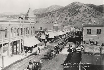
#OnThisDay in 1913, construction started on the Grand Valley Project in CO. #COWater http://t.co/UgHHbJa88H
— Reclamation (@usbr) September 23, 2014


#OnThisDay in 1913, construction started on the Grand Valley Project in CO. #COWater http://t.co/UgHHbJa88H
— Reclamation (@usbr) September 23, 2014

From Rocky Mountain PBS (Jim Trotter):
The surface elevation of Lake Mead reached the historic low of 1,081.75 feet above sea level during the week of July 7, according to the Bureau of Reclamation. On Aug. 13, the bureau reported the level at 1,080. But as of Wednesday, it had inched back to 1,081.31.
This is all being closely watched by the seven states and Mexico that share Colorado River water. Should Mead fall to 1,075 feet it would trigger a declared shortage on the river, at which point water deliveries could be impacted.
The lake has dropped 128 feet since 2000, during the prolonged drought over big stretches of both the upper and lower basins. But the Upper Colorado River Basin runoff this spring and summer was 94 percent of average, compared to only 47 percent in 2013 and 45 percent in 2012.
Last month, the bureau said it expected a release to Mead from upstream Lake Powell of 8.23 million acre feet during water year 2015, an improvement on the 7.48 million acre feet for water year 2014…
But even with enhanced deliveries from Lake Powell, the bureau has projected that Mead will continue to fall in 2015.
In an interview with Rocky Mountain PBS I-News, Brad Udall, a Western water expert and senior fellow at the University of Colorado School of Law, summed up Lake Mead’s dilemma.
“The problem with Lake Mead is that it’s overused by 1.2 million acre feet every year,” Udall said. “With increased demands and with climate change, it’s a double wallop. What do we do with this 1.2 million acre-feet deficit?”
Ultimately, it might mean revisiting “the Law of the River,” the infinitely complex and arcane set of rules that govern the river’s use, starting with the Colorado River Compact of 1922, and changed by many agreements, lawsuits and rulings since, including acts of Congress and a Supreme Court decree.
More Colorado River Basin coverage here.
From The Aspen Times (John Stroud):
Colorado River District officials worry that possible Wild and Scenic designation for part of the Crystal River could sell western Colorado water interests short when it comes to the need for future storage projects, at least one River District board member advised Garfield County commissioners this week.
“We continue to see the Crystal River as an important water supply for western Colorado,” Dave Merritt, Garfield County’s representative on the 15-member River District board, said during a meeting earlier this week to discuss the proposal.
The push to give Wild and Scenic status to a 39-mile stretch of the Crystal south of Carbondale, from it headwaters in the Maroon Bells-Snowmass Wilderness to the Sweet-Jessup Ditch headgate just below Avalanche Creek, “attempts to make a determination that the way the river is now is the way should be forever, and that’s a long time,” Merritt said.
“We believe that we need to be able to provide for those who come behind us the same opportunities that we’ve had, and the Crystal River is place where we can meet the needs of the future,” he said, adding there is also concern that the designation could remove local control in favor of federal protections.
County commissioners requested the meeting with River District and White River National Forest officials to get a better understanding of what Wild and Scenic designation would mean, and to offer their thoughts…
Any questions and concerns from the county, the River District or any other entity can be addressed in the eventual federal legislation that would have to go to Congress for consideration, said Redstone resident Bill Jochems.
“The Wild and Scenic Act has great flexibility to address those concerns,” Jochems said, noting that the full River District board has not voted on the proposal, nor will it or the county be asked to do so until the draft legislation is written.
“All we’re asking for is that there be no dams on the main stem of the Crystal above (Sweet-Jessup),” Jochems said. “And it’s not like we’re trying to prevent it forever.”
Small water storage projects could still be pursued downstream of the designation, or on any of the tributaries, he said…
White River National Forest staffers Rich Doak and Kay Hopkins explained that the Crystal River has been listed as eligible for Wild and Scenic status dating back to 1982, and reaffirmed in 2002.
The section of river being studied for formal designation does exhibit many of the “outstanding and remarkable” natural, cultural, historic and recreational values (ORVs) spelled out in the Wild and Scenic Act of 1968.
A key element is also that the proposed waterway be free-flowing. However, it’s possible that streams below an existing dam can be designated as Wild and Scenic, as long as the water releases are adequate to support the identified ORVs, Hopkins said.
“This is the stage of the process where all the hard questions are asked, and is the big planning part of the study,” she said.
The Garfield commissioners sought assurances that existing water rights would be maintained. Commissioner John Martin also asked that stormwater detention projects be addressed in the proposal, pointing to legal struggles in El Paso County related to the ability to build detention ponds.
“The nice thing about this process is that we can take those kinds of things into consideration,” Doak said.
The Crystal River is one of just five waterways out of 72 within the White River National Forest that meet the national Wild and Scenic standard, Hopkins added.
Others include Cross Creek on the east side of the Holy Cross Wilderness, the South Fork of the White River, and two streams nearing a formal suitability decision by Forest Service and Bureau of Land Management officials later this fall, Deep Creek and the portion of the Colorado River in Glenwood Canyon.
Once a record of decision is made on those two waterways, a legislative “advocate” would need to be identified to carry the bill in Congress, Hopkins said.
Since the Wild and Scenic Act was adopted, only one river in Colorado, the Cache le Poudre River west of Fort Collins, has such designation.
More Crystal River coverage here.
From the Aspen Daily News (Collin Szewczyk):
Through a program by the Roaring Fork Conservancy, a group of over 20 people seeking to quench their intellectual curiosities concerning the city’s water, how it’s treated and where it comes from, toured the city of Aspen’s drinking water treatment facility this week led by water treatment supervisor Charlie Bailey and Laura Taylor, an operator at the facility.
Christina Medved, watershed education director of the Roaring Fork Conservancy, pointed out the parameters of the Roaring Fork watershed, noting that local rivers and streams are fed from an area the size of a small Eastern state.
“Our watershed is about the size of Rhode Island,” she said. “And over 30 percent of it is in designated wilderness areas.”
She praised the relationship that the conservancy has with local government entities such as the city water department, that allows visitors to check out local facilities, which are normally closed to the general public.
“What’s really exciting is we get access to places like this,” Medved said. “We have really wonderful partners that will say, ‘yeah, we’ll open up the gate for you,’ when you normally can’t get in here and have an audience with Charlie and Laura because they’re busy bringing water to Aspen.”
Aspenitus
The plant was completed in December 1966 after Aspen endured a major waterborne epidemic of giardia in the mid-1960s. Giardia is a microscopic parasite that is found in soil, food or water that is contaminated with feces. Another parasite, cryptosporidium, has yet to appear in the Aspen area.“That was 1964-65; it was the first documented public health problem in the United States,” said Bailey. “There was a documented waterborne problem and that was giardia. There were two redwood tanks up on the hill here that were used for the hydro plant that was down the street, but the Aspen Water Company provided water to the pipes and there was no treatment at all … It was a big hit, they called it ‘Aspenitus.’”
After the outbreak, the city got money together, bought bonds and broke ground on the treatment plant in 1965. There’s been no cases of giardia in the city’s water since the building of the facility, Bailey said.
“There’s lots of giardia in the water and none of it comes out of the pipeline here,” he said. “We’re required to do testing once a year on the performance of our filters and our clear well (a reservoir used for storing filtered water, which flows through a series of baffles, allowing contact time with chlorine for disinfection).”
Beavers were the main culprit for the giardia epidemic, and the area up Maroon and Castle creeks was teeming with them at the time.
“There was a huge beaver population up there,” Bailey said, but added that it’s good to have them in the area. “They’re animals that let us know that the environment is healthy.”
The water plant also checks the water for mining tailings and other non-natural pollutants.
“We’ve requested extra testing of our water sources,” Bailey said. “We’ve done heavy metal testing and we actually do [pharmaceutical] testing, too.”
He added that no traces of either have been found in Aspen’s drinking water.
“Ever since I’ve been here, and even before, there’s been no problem with city water,” he said. “No public outbreaks, no boil orders, because I will not let it happen on my watch.
“We make the water, and the best thing about making the water here is that it’s clean,” Bailey continued. “The water comes from wilderness areas and there is nobody up above us that has dumped back [into the creeks] after industrial processes or anything like that. We get water coming through the geology, through the snowmelt, we are stewards of the water so we really keep track of everything above us and below us.”[…]
The water here is pumped in from Maroon and Castle creeks and begins its journey through the treatment facility and into Aspen taps. He noted that the city has water rights of 142 cubic feet per second (cfs) in Maroon Creek and about 90 cfs in Castle Creek, even though the streams only hit that level during spring runoff…
The purification process
The reservoir, which holds about 4 million gallons in the summer, is the first stop in the purifying process as sediment in the water begins to settle here.“This is one of our processes,” Bailey said. “We basically bring the water in here and we slow it down. This helps so much during [peak] runoff … the dirt is tumbling, it’s coming in and all the sudden it settles out here and we’re able to draw off the surface and it’s much, much cleaner.”
He added that the water is usually at about one turbidity unit (TU) — the measurement of cloudiness caused by particulates — when it enters the reservoir. When it leaves it’s at .5 TU; during peak runoff it can be as dirty as 60 TU.
“We get reduction in here,” Bailey said. “That’s just a natural tumbling process, we slow it down and that stuff just falls out.”
The nutrient-rich sediment has to be periodically dug out, but it gets spread around the site making the soil perfect for plant growth.
To the north side of the reservoir lies the remnants of the old Maroon Creek flume that was used to divert water to the “tent city” in the late 1800s. As the group was looking down on the wooden channel one observer noticed a bear hanging out in a nearby tree, adding to the natural feel of the site.
The water next goes into large flocculation tanks — which look like UFOs — that, with the aid of chemicals, coagulate the particulates, churn them about and make the sediment again settle to the bottom.
After settling twice, the water makes its journey to a filtration section of the facility. Here, it’s pushed by gravity through a filter that consists of 18 inches of anthracite (coal) and a foot of sand. It next heads to the clear well for 14 to 15 hours to ensure all giardia is killed.
The state’s regulation allows for drinking water to reach one TU and still be acceptable to drink, but on this day Aspen’s drinking water was a pristine 0.037 TU.
More water treatment coverage here.
From the Environmental Protection Agency (Ken Kopocis) via AgWeek:
When Congress passed the Clean Water Act in 1972, it didn’t just defend the mighty Mississippi or the Great Lakes; it also protected smaller streams and wetlands from pollution. The law recognized that to have healthy communities downstream, we need healthy headwaters upstream.
EPA and the U.S. Army Corps of Engineers took targeted action in March to protect the clean water vital to our health and our economy. Science clearly shows us what kinds of streams and wetlands impact water downstream — so our proposal protects those waters.
There’s been some confusion about EPA and the Army Corps’ proposal, especially in the agriculture community. We want to make sure you know the facts.
The agencies’ intent is to protect clean water without getting in the way of farming and ranching. Normal farming and ranching — including planting, harvesting and moving livestock — have always been exempt from Clean Water Act regulation, and our proposal doesn’t change that. We worked with U.S. Department of Agriculture’s Natural Resource Conservation Service and the Army Corps of Engineers to exempt 56 conservation practices familiar to many farmers, such as range planting and wetland restoration, who know their benefits to business, the land and water resources.
Despite the myths we’re hearing from some critics, the Clean Water Act only deals with the pollution and destruction of waterways — not land use. Nor does this proposal affect private property rights. Also, the proposal does not regulate new types of ditches, does not apply to groundwater, and does not change the exemption for stock ponds.
With the western U.S. in historic drought, and after seeing how water pollution can threaten communities like Toledo, Ohio, and Charleston, W.Va., the proposal is more important than ever. Paul Schwartz, a farmer from Hotchkiss, Colo., agrees.
“[EPA’s proposal] will provide needed clarity and help address very real water challenges,” he says.
EPA is not interested in a final rule that will make farming more difficult. The agency’s job is to protect our natural resources so farmers can keep doing what they do best — farming.
We understand people have legitimate questions and concerns about the proposal, and we are committed to listening to America’s farmers and ranchers. But we can all agree that protecting the long-term health of our nation’s waters is essential. The public comment period for the proposal is open until Oct. 20, and your input will make sure we get to a strong, achievable final rule.
More Environmental Protection Agency coverage here.
Lukas: April 1 snowpack decreases in most projections and SWE won't be as good a predictor of spring summer streamflow. #ColoradoWater
— John Orr (@CoyoteGulch) September 19, 2014
At last week’s Colorado River District Annual Seminar Jeff Lukas warned that the reliance on the April 1 snowpack to predict streamflow will be lessened by climate change. Nevertheless old habits die hard. Below are Klaus Wolter’s first passes at the January 1 and April 1 SWE, presented last week at the Colorado Water Conservation Board’s Water Availability Task Force meeting. Click here to view Klaus’ slides.
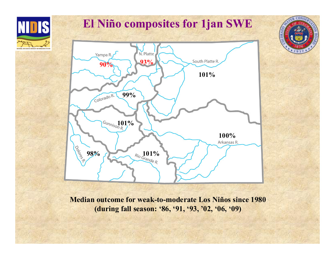


Click here to go to the Climate Predication Center website.
I wrote about the mistaken conflation of "#Fracking" with #oil+#gas development in general back in 2012: http://t.co/mwfcrLDI9O #wordsmatter
— Jonathan P. Thompson (@jonnypeace) September 18, 2014

Here’s the release from the San Juan Citizens Alliance:
The House Committee on Natural Resources failed today to honor the community consensus on the protection of the Hermosa Creek watershed that was fashioned by diverse stakeholders over many years.
The Committee voted 22 to 18 to approve an amended version of the Hermosa Creek Watershed Protection Act (HR 1839), stripping many of the watershed protections and transferring management decisions from localized decision-making to Congressional dictates.
Unfortunately, Rep. Scott Tipton failed to support the community’s consensus, which included very specific protective measures, by voting with the majority to severely alter the locally crafted legislation despite his previous indications that he would honor the legislation as he introduced it to Congress.
Numerous stakeholders involved in the Hermosa Workgroup process that spawned the legislation were incredulous that a “perfectly delivered” legislative process, created locally with near-unanimous support, could be bungled so badly as it moved forward in the House of Representatives. Mark Franklin, a La Plata County business owner, noted, “How possibly could a bipartisan supported piece of legislation to protect a locale so loved by locals be twisted into an effort to promote partisan public lands-related grudges? We were so confident that Rep. Tipton would say, ‘My constituents fashioned this bill in harmony, I stand behind it, please pass it as I introduced it – no modifications are needed’, but he did not.”
The possibilities of resurrecting the legislation to reflect the community consensus are uncertain at this point. Jimbo Buickerood, San Juan Citizens Alliance’s Public Lands Coordinator, stated “In the weeks ahead I’m sure Rep. Tipton will hear from his constituency “loud and clear” that the Hermosa Creek watershed is dear to us and we want it protected as we clearly indicated in the legislation we created. Hopefully from there the Congressman will lead the charge to make the necessary changes on the House floor or in conference to bring home a locally-fashioned prize, rather than a Washington DC designed edict.”
Here’s a response from The Durango Herald editorial board:
In a last-minute dirty trick that could wipe away six years of local consensus-building to protect the Hermosa Creek watershed, the House Committee on Natural Resources circulated a new version of the Hermosa Creek Watershed Protection Act – this one drafted in secret without local input – two days before the committee was to take up the matter. The new language undermines key provisions that enjoyed near-universal local support, replacing them with edicts that run counter to the original measure’s intent, and could set a dangerous precedent for wilderness management nationwide. It is an unacceptable move that U.S. Rep. Scott Tipton, the bill’s House sponsor, should push his colleagues to rectify.
The Hermosa Creek Watershed Protection Act has a rare and elusive pedigree. The measure that would protect 108,000 acres of beloved forest terrain north of Durango is the progeny of a wide-ranging group of local stakeholders from even farther-flung ideology and interests that convened to discuss how to preserve the pristine Hermosa Creek area and all its varied resources. This lengthy, thorough and painstaking process bore a consensus among wilderness advocates, water and mining interests, snowmobilers, business owners, mountain bikers, backcountry hunters, anglers and horsemen, county commissioners, city councilors and many others who worked over several years to craft recommendations for legislation.
The ensuing measure has won the hearts – and political capital – of U.S. senators and representatives from both parties and over several sessions of Congress. It has moved painstakingly slowly, but with steady, consistent, widespread support locally, regionally and federally. As close as lands protection legislation can be – or any legislation at all, these days – the Hermosa Creek bill was a slam dunk. In fact, it is just the sort of thing House Republicans claim they prefer: a locally crafted plan that represents the interests and values of bipartisan stakeholders. Despite this, the measure has moved slowly through a gridlocked Congress, and there has been little news of its progress since a subcommittee hearing in May – other than reiterations from the bill’s numbered and varied supporters that they hoped for action soon.
On Tuesday, though, everything changed when the committee announced a markup scheduled for today and distributed an updated version that would redefine the special management area so as to significantly diminish the local role in crafting a management plan for the newly protected area, ceding that power to Congress instead. Further, the new bill would allow for dam construction within the protection area, should the need someday arise – something the original measure allowed as well – but it goes on to suggest that any associated roads and transmission lines could bisect the measure’s wilderness areas. That has dramatic implications for wilderness management nationwide.
These changes are drastic. They are so profoundly at odds with the locally crafted recommendations that informed the original Hermosa Creek bill as to be antithetical. Unlike the process that yielded the original measure, the committee action took place in secret, without local buy-in and delivers a top-down edict that deeply undermines many years of hard work. Tipton must defend that local consensus and amend the bill to set right what was so inappropriately and surprisingly altered.
From the Colorado Water Conservation Board (Taryn Finnessey/Tracy Kosloff):
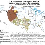
Mild temperatures and above average precipitation has persisted across northern Colorado and portions of the eastern plains, bringing continued drought relief to some of drought stricken Colorado. Forecasts for the coming months indicate that further drought relief is likely in this region. The Rio Grande basin has received less precipitation and conditions there are being closely monitored. Along the Front Range, water providers indicated that storage levels are at, or near, record levels and demand is down.
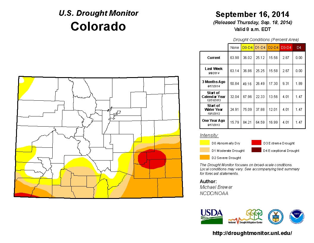
Currently, 36% of the state is in some level of drought classification according to the US Drought Monitor. 11% is characterized as “abnormally dry” or D0, while an additional 10% is experiencing D1, moderate drought conditions. 13% is classified as severe, 3% as extreme and none of the state is in exceptional drought (D4). Despite recent rains on the eastern plains, the Pueblo weather station is still running a deficit both for the water year and on a 4 year time frame. The 15.58 inch deficit over the last four years illustrates how difficult it can be to recover from persistent drought conditions. Walsh, further down the Arkansas basin, is experiencing a 17.56 inch deficit over the same 4 year period. Year-to-date precipitation at mountain SNOTEL sites remains at 103% of average. July and August, both saw above average precipitation totals, 122 and 112% respectively, while September to-date is right at average. Storms have largely missed the area of extreme drought that remains near the intersection of Crowley, Kiowa, Otero and Bent counties. Reservoir Storage statewide is at 100% of average at the end of August 2014, 28% ahead of where we were for storage this time last year. The lowest reservoir storage statewide continues to be the Upper Rio Grande, with 61% of average storage. The South Platte has the highest storage level at 138% of average. In general, storage is stronger in the northern basins than in the southern river basins. The Surface Water Supply Index (SWSI) for the state is near normal across much of the state, with an “abundant” index in a few northern basins of the South Platte, North Platte, Yampa/White, and Colorado. The lowest values in the state are in the Southwest and Rio Grande reflect very low reservoir and streamflow levels. This area of the state has not received the same moisture as the rest of the state. A weak El Nino is expected to continue as a weak-to-moderate event into early next year. Such an event
may bring wetter than average conditions to the eastern plains for late winter into early spring. Drier
conditions may develop in northwestern Colorado and the Colorado River basin.


Click here to go to the US Drought Monitor website. Here’s an excerpt:
Summary
Coming on the heels of the ninth wettest summer on record for the U.S. (according to the National Climatic Data Center), continued rain this Drought Monitor week led to minor improvements in drought conditions from the Southwest, through the Southern Plains, and into the Midwest. A near-complete lack of precipitation means drought continues largely unabated through California and along the West Coast. Another week of continued dryness saw drought conditions intensifying across the Hawaiian Islands…
The Plains
Locally heavy rain came to the Southern Plains during this Drought Monitor week. Areas from southeastern New Mexico and into western and northern Texas benefited. Texas also experienced improvements along the southern Gulf Coast. Central Texas saw some degradation in drought conditions as did the coastal area around Houston. Improvement continues in Kansas with the eradication of Extreme Dryness (D3) in the western part of the state and minor improvements in the north. Minor improvements were also experienced in South Dakota, Nebraska, and Oklahoma…
The West
Moisture fell in much of the West this week, with the exception of the West Coast and Pacific Northwest. Rain and occasional snow from Montana down to New Mexico led to minor improvements throughout the area. Idaho and Oregon largely missed that precipitation and subsequently degradation in drought conditions took place along the southern border of those two states. The Pacific Coast continues to be the hotbed of fire activity in the country with all 15 current large incident fires occurring in California, Oregon, and Washington. To date, wildfires have burned 2,935,074 acres of the U.S., well below the 6,560,844 acre average for the same time of year (source: National Interagency Fire Center)…
Looking Ahead
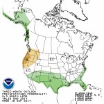
During the September 17- 22, 2014 time period, the remnants of Tropical Storm Odile are expected to bring heavy precipitation and flooding to the Southwest, particularly in southern Arizona and New Mexico. Beyond that event, precipitation is expected from the Southwest, through the Plains, and into the Ohio River Valley. At the same time, above normal temperatures are expected along the northern tier of the nation with warmer than average minimum temperatures across the nation with the exception of the East Coast.
For the ensuing 5 days (September 23-27, 2014), the odds favor normal to above-normal temperatures across the western U.S. and along the Gulf of Mexico Coast. Below-normal temperatures are favored around the Great Lakes and into New England. Above-normal precipitation is likely along the Gulf of Mexico Coast and in the Four Corners area of the Southwest. Below-normal precipitation is expected in the Plains and throughout much of the West. Alaska is likely to see above-normal temperatures and below-normal precipitation over much of the southern part of the state.
From The Pueblo Chieftain (Chris Woodka):
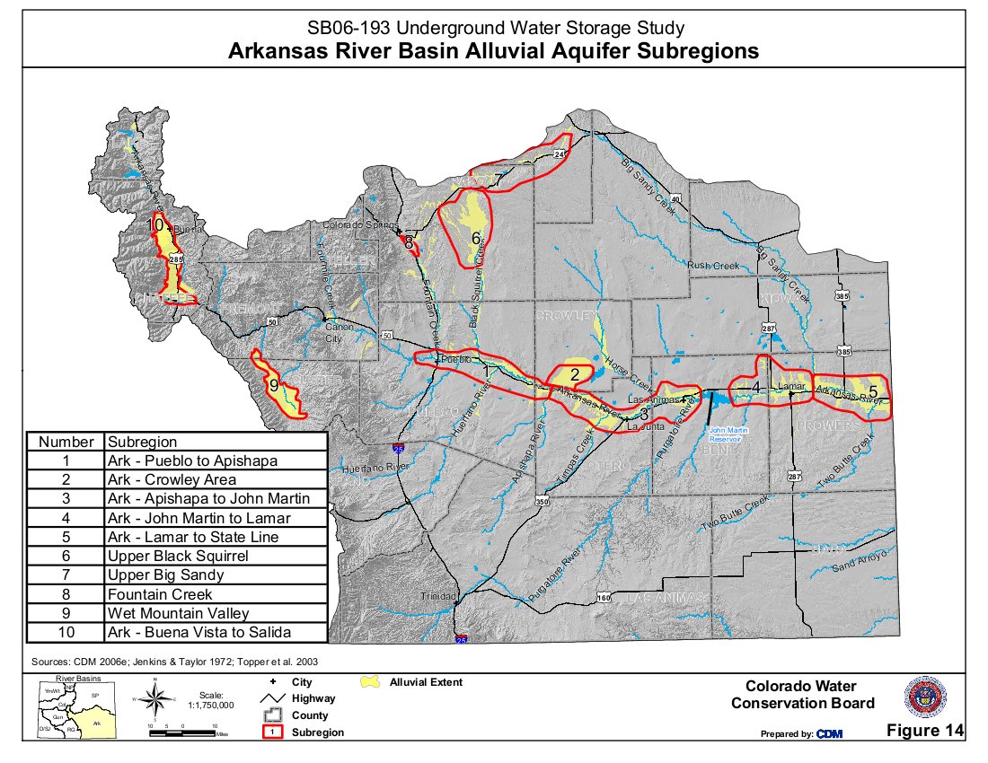
A federal project to map groundwater changes in the Lower Arkansas River was approved by a local board last week. The Lower Arkansas Valley Water Conservancy District voted to spend $45,300 toward a program that will look at changes in groundwater levels during the irrigation season. The project will be conducted by the U.S. Geological Survey, which is contributing $23,260.
“We measure the late fall and early spring water levels,” said Ken Watts, Pueblo scientist for the USGS. “The change in the fall measures the recharge in the system. Groundwater storage is far greater than surface storage.”
The Arkansas River aquifer is about a mile wide, 30 feet deep and 150 miles long, he explained.
The USGS measures eight surface gauges and 144 wells east of Pueblo. Watts proposed eliminating the spring measurement in order to pay for a mapping project under the current funding level of about $52,000. While the USGS has measured the area for years, the data are available only in tables. Mapping would be available online and provide an easier way to compare numbers.
The Lower Ark board voted to add $10,300 of its own money, matched with $5,820 in USGS funds to fund a more complete project.
The data is useful for several reasons, including well pumping regulations, surface irrigation plan and long-term studies.
“Surface supply and groundwater are connected,” Watts said. “If you drop groundwater levels, that will pull water to the aquifer.”
“It’s good data, and ties into the Arkansas River decision support system,” said Bill Tyner, assistant Division 2 engineer. “The data are helpful because of the difference we’ve seen in the last few irrigation seasons.”
More Arkansas River Basin coverage here.

From The Pueblo Chieftain (Chris Woodka):
The Pueblo Dam could start generating hydropower as soon as 2018. The Southeastern Colorado Water Conservancy District got an update Thursday on its proposal to construct hydropower on the new north outlet works from project manager Kevin Meador.
“We’re a couple of years from bidding the project,” Meador said. “I’m feeling optimistic at this point.”
The district, in partnership with Colorado Springs Utilities and the Pueblo Board of Water Works, is working on a lease of power privilege proposal with the federal Bureau of Reclamation. It should be finalized in February.
An unknown in the project is whether Black Hills Energy, the primary power supplier for the area, will enter a power purchase agreement for the hydropower.
“That could go very smoothly or take a while,” Meador said.
If a Black Hills agreement is not reached, another provider could be approached, including Colorado Springs Utilities.
Utilities constructed the new north outlet works as part of the Southern Delivery System. It will be owned by Reclamation as soon as a contract checklist is completed, said Roy Vaughan, Fryingpan-Arkansas Project manager for Reclamation. The hydropower plant would generate 7 megawatts of electric power and cost about $20 million. A loan will be sought in 2015 through the Colorado Water Conservation Board to finance the project. Construction would begin later next year, Meador said.
“Generation could begin in the early spring of 2018,” he said.
More Southeastern Colorado Water Conservancy District coverage here.
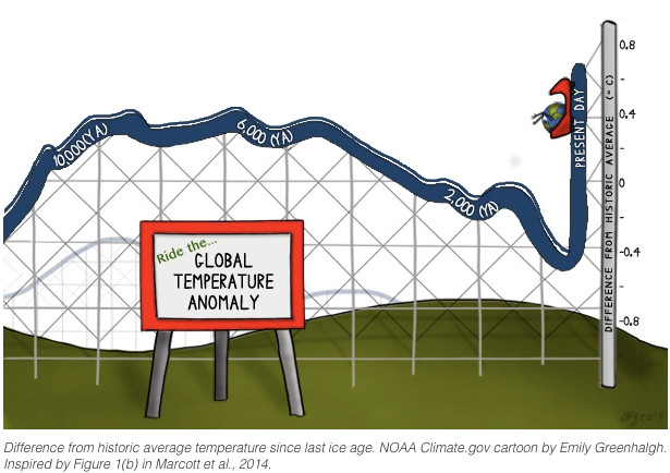
From Climate.gov:
This article is the second of two articles describing the hottest time periods in Earth’s history.
Throughout its 4.54-billion-year history, Earth has experienced multiple periods of temperatures hotter than today’s. But as far as the “recent” past, a study published in March 2013 concluded that global average temperature is now higher than it has been for most of the last 11,300 years.
The scientists assembled dozens of temperature records from multiple studies, including data from sediment cores drilled in lake bottoms and sea floors, and from ice cores. Assembling data from 73 records that overlap in time, the scientists pieced together global average temperatures since the end of the last ice age.
The 11,000-year temperature reconstruction shows global average temperature increasing after the end of the last ice age and leveling off about 7550 and 3550 BC. After that time, global temperatures dropped until the “Little Ice Age,” bottoming out somewhere between AD 1450 and 1850. Afterwards temperatures rose again, first slowly then very rapidly. (The estimated temperatures for the past 1,500 years correlated with previous research that covered the same time period.)
Natural variability can explain much of the temperature variation since the end of the last ice age, resulting from factors such as changes in the tilt of the Earth’s axis. Over the past century, though, global average temperatures have “risen from near the coldest to the warmest levels” in the past 11,300 years, the 2013 study authors explain. Over this same period, emissions of heat-trapping gases from human activities have increased.
Given the uncertainty inherent in estimating ancient temperatures, the scientists conservatively concluded that the last decade has brought global average temperatures higher than they have been for at least 75 percent of the last 11,300 years. The recent increase in global average temperature is so abrupt compared to the rest of the time period that when the scientists make a graph of the data, the end of the line is nearly vertical.
What about the future? To project future temperatures, the research team used greenhouse gas emission scenarios outlined in the Intergovernmental Panel on Climate Change (IPCC) Climate Change 2007: The Physical Science Basis report, and the authors expect the steep increase to continue through the year 2100 regardless of which one of the emission scenarios from the 2007 report is considered.
For most of the past 10,000 years, global average temperature has remained relatively stable and low compared to earlier hothouse conditions in our planet’s history. Now, temperature is among the highest experienced not only in the “recent” past—the past 11,000 years or so, during which modern human civilization developed—but also probably for a much longer period.
Carrie Morrill of the National Climatic Data Center explains, “You’d have to go back to the last interglacial [warm period between ice ages] about 125,000 years ago to find temperatures significantly higher than temperatures of today.”

I’m on the road today heading back over to the South Platte River basin and home.
The Colorado River District’s annual seminar yesterday was a hoot. Check out all the Tweets at #ColoradoWater.

I’ll be live-Tweeting the Colorado River District Annual Seminar today assuming that I can find Two Rivers Convention Center from the bike trail from my camp spot in Fruita. I don’t know what hash tag we’ll be using yet so follow along (@CoyoteGulch).

From the Fort Collins Coloradoan (Seth Borenstein):
The drilling procedure called fracking didn’t cause much-publicized cases of tainted groundwater in areas of the states of Pennsylvania and Texas, a new study finds. Instead, it blames the contamination on problems in pipes and seals in natural gas wells.
After looking at dozens of cases of suspected contamination, the scientists focused on eight hydraulically fractured wells in those states, where they chemically linked the tainted water to the gas wells. They then used chemical analysis to figure out when in the process of gas extraction methane leaked into groundwater.
“We found the evidence suggested that fracking was not to blame, that it was actually a well integrity issue,” said Ohio State University geochemist Thomas Darrah, lead author of the study. He said those results are good news because that type of contamination problem is easier to fix and is more preventable.
The work was released Monday by The Proceedings of the National Academy of Sciences…
In at least two cases around one well in Texas, scientists saw people’s homes have their water supplies go from clean to contaminated during the year of study, with methane levels jumping ten-fold, said Stanford University environmental sciences professor Rob Jackson, co-author of the study. Methane, while not particularly toxic, is explosive and a potent greenhouse gas.
“I don’t think homeowners care what step in the process the water contamination comes,” Jackson said. “They just care that their lives have changed because drilling has moved next door.”
The scientists reached their conclusions by chemically analyzing methane and other chemicals in the groundwater. That let them link the contamination to particular wells, and then to discover what part of the drilling process was responsible. For example, they studied the precise proportions of methane, helium, neon and argon. Those proportions pointed to leaky pipes and seals, because the results would have been different if the contamination had come from fracking…
Cornell University engineering professor Anthony Ingraffea, who wasn’t part of the study, praised it, adding that he’s worried because “it’s impossible to drill and cement a well that will never leak.”
“There’s still serious and significant harm from what’s coming before fracking and what’s coming after fracking,” Ingraffea said.
More oil and gas coverage here.

Click here to read the current assessment. Click here to go to the NIDIS website hosted by the Colorado Climate Center.
More Colorado River Basin coverage here.


From The Pueblo Chieftain (Chris Woodka):
The Colorado Water Conservation Board last week approved a pilot project that will provide the town of Fowler water from several farms on the Catlin Canal over the next 10 years. The project is the first to be attempted under 2013 legislation, HB1248, that authorized demonstration projects that determine if lease-fallowing projects are a viable alternative to permanent dry-up of farms. It is also the first test of the viability of the Arkansas Valley Super Ditch.
Participating farms would be dried up no more than three years of the next 10 in order to supply 500 acre-feet (163 million gallons) annually to Fowler. Seven farms with 1,128 acres will be dried up on a rotational basis to provide the water under a plan filed by the Lower Arkansas Valley Water Conservancy District and the Arkansas Valley Super Ditch.
The CWCB reviewed comments on the project expressing concern from Aurora, the Lower Arkansas Water Management Association, Tri-State Generation and Transmission Association, the Southeastern Colorado Water Conservancy District and Colorado Beef, a Lamar feed lot. The comments were similar to filings made in the past in water court cases that sought to permanently change water rights. Most expressed concern that their water rights would not be injured by the program and sought to assure that measurements in the program are accurate. Some were supportive of the program and all wanted to be notified of progress or changes in the program.
“We’re trying to see if a lease-fallowing program is viable,” said Jay Winner, general manager of the Lower Arkansas Valley Water Conservancy District. “We’re trying to keep the water in the Arkansas basin. That’s what it’s all about.”
From The Pueblo Chieftain (Chris Woodka):
How much water is staying down on the farm?
The state will spend $175,000 to study the amount of water returning to the Arkansas River from fields on the Fort Lyon Canal. That will be matched with $50,000 from the Lower Arkansas Valley Water Conservancy District. The Colorado Water Conservation Board approved the grant last week as a way to address contentions from farmers that the amount of tailwater return to the Arkansas River has been overestimated. The outcome could affect the formulas used by the Colorado Division of Water Resources in administering the Arkansas River Compact and rules that govern wells or surface irrigation. It could also make more water available to farmers to lease under the Super Ditch or other rotational lease-fallow programs.
The grant was approved in July by the Arkansas Basin Roundtable.
The state now recognizes a 10 percent return of water from fields, or tailwater, that are flood irrigated. That water must be replaced under state rules adopted during the 24-year Kansas v. Colorado court case.
The Fort Lyon Canal is 100 miles long and irrigates 94,000 acres, so farmers contend water soaks into the ground and never makes it to the river. It is anticipated that the collection and analysis of data will take about two years to complete, at which time further work could be contemplated.
From The Pueblo Chieftain (Chris Woodka):
Leaky ponds are good news for farmers in the Lower Arkansas Valley. The second year of a pond study in a normal water year is showing similar results as last year, when drought gripped the region.
“We’re not seeing a significant difference,” said Brian Lauritsen, a consultant on the study being funded through the Lower Arkansas Valley Water Conservancy District and the Colorado Water Conservation Board.
Water leakage on more than 20 ponds averaged about 20 percent this year, compared with 18 percent last year. Most are on the Fort Lyon Canal. It had been thought the numbers would be higher when the ground was drier.
“Usually, you don’t want to see ponds leaking,” said Jack Goble, engineer for the Lower Ark district.
But in this case, there is a chance the state will adjust its formula used to determine how much water irrigators owe for return flows that are reduced through more efficient irrigation techniques such as sprinklers. More leakage means less water owed to the river.
The Lower Ark also has built two ponds on the Catlin Canal designed specifically to leak. Called recharge ponds, they are designed to return water to the Arkansas River over time, the way that water flows through the aquifer in farming operations. One pond fills part of the need for Rule 10 surface irrigation plans, while the other is credited to Rule 14 well plans. One pond contributed 135 acre-feet (44 million gallons) in a month, while the other leaked 120 acre-feet (40 million gallons) in 21 days.
“I hope we’re able to get more of these ponds, especially in the lower part of the basin,” said Jay Winner, general manager of the Lower Ark District.
More HB13-1248 coverage here. More Lower Arkansas Valley Water Conservancy District coverage here.
From the Colorado Springs Independent (J. Adrian Stanley):
Just before the El Paso County commissioners passed a resolution opposing a proposed change to the federal Clean Water Act last week, Commissioner Sallie Clark had something to say.
“Imagine if every little drainage way was considered a navigable waterway as it relates to requiring permitting,” Clark, who brought the resolution, said from the dais. “It’s just one more example of the [Environmental Protection Agency’s] overreach on everything from the Endangered Species Act to everything that they do.”
The Endangered Species Act is not administered by the EPA. But that didn’t stop Commissioner Amy Lathen from chiming in.
“Our fundamental responsibility is the protection of private property rights,” she said, “and what the feds do [has] a chilling, chilling impact on land. They sterilize land, they erode private property rights.”
The resolution was approved unanimously, with Commissioner Dennis Hisey absent.
The commissioners aren’t the only ones crying foul about the proposed change, which would define the “waters of the U.S.” and therefore the bodies subject to the Clean Water Act, enacted in 1972 to prevent pollution. However, a representative of the EPA, which is proposing the change along with the Army Corps of Engineers, says concerns like those of the commissioners are unfounded, and rooted in a misunderstanding of how the act works.
Lots of concern
Hours after the commissioners took their Sept. 9 vote, Republican U.S. Congressmen Scott Tipton and Cory Gardner, both of Colorado, sent out press releases noting that a bill they cosponsored, the Water Rights Protection Act, had passed the House and moved to the Senate. H.R. 3189 aims to prevent the EPA and the Corps from making the proposed changes to the Clean Water Act, which Tipton calls “a gross federal overreach” that would expand the act to cover virtually every form of surface water. Gardner says the proposal would even regulate a “puddle.” (Gardner’s “puddle” claim is one of many addressed at the EPA’s Ditch the Myth site, tiny.cc/ditch-myth-cs.)
U.S. Sen. Mark Udall, D-Colo., is usually a proponent of the environment. Asked whether he supported the change, his office issued a statement saying simply that he encouraged constituents to give feedback to the EPA, which has extended a comment period to Oct. 20.
County public services executive director Jim Reid says the changes would mean that every time the county tries to approve a water project, it would need to pay for two permits relating to water quality, which could take as long as a year and cost thousands of dollars. The change would mean that instead of just protecting “navigable waters,” there would suddenly be federal protection for any waterway, he says, even a dry streambed. That could affect the ability to control stormwater and floods.
“There could be more infrastructure damage while we’re waiting for those permits to get through,” he says.
A different explanation
But is that really true?
No, says Karen Hamilton, chief of the EPA’s aquatic resource protection and accountability unit. Many are confused about what the Clean Water Act already regulates, she says. The EPA has jurisdiction over most surface water, not just “navigable waters,” and this proposed change wouldn’t add any new waters.
The point of the change, she says, is to make permitting for water projects easier. It was proposed after over 100 parties complained to the EPA that new rule-making was needed to clarify the act — everyone from Susan Gordon of Venetucci Farm to the American Petroleum Institute. Projects sometimes required lengthy jurisdictional reviews to determine if a permit was needed.
Hamilton says the EPA considered over 1,000 scientific articles when it assembled ways of determining which waters are covered. (The regulation also includes a list of types of waters that are not covered.) It should mean that fewer projects require jurisdictional review.
Two entities in Colorado issue permits related to the Clean Water Act: the state and the Corps. Allan Steinle, regulatory division chief for the Albuquerque District of the Corps, which includes our area, says of the change, “I don’t think it’s going to be very significant … It will actually make things easier for us and for the public.”
Martha Rudolph, director of environmental programs for the state, agrees that permitting requirements for projects should not increase, as Reid and others fear. But she understands where those fears come from, saying the proposed regulation sometimes sounds like an expansion of powers. So the state has asked the EPA to change that language so that it doesn’t look like a power grab.
“I would agree that there needs to be some clarification in the regulatory language,” she says, “to make that abundantly clear.”
More Environmental Protection Agency coverage here.
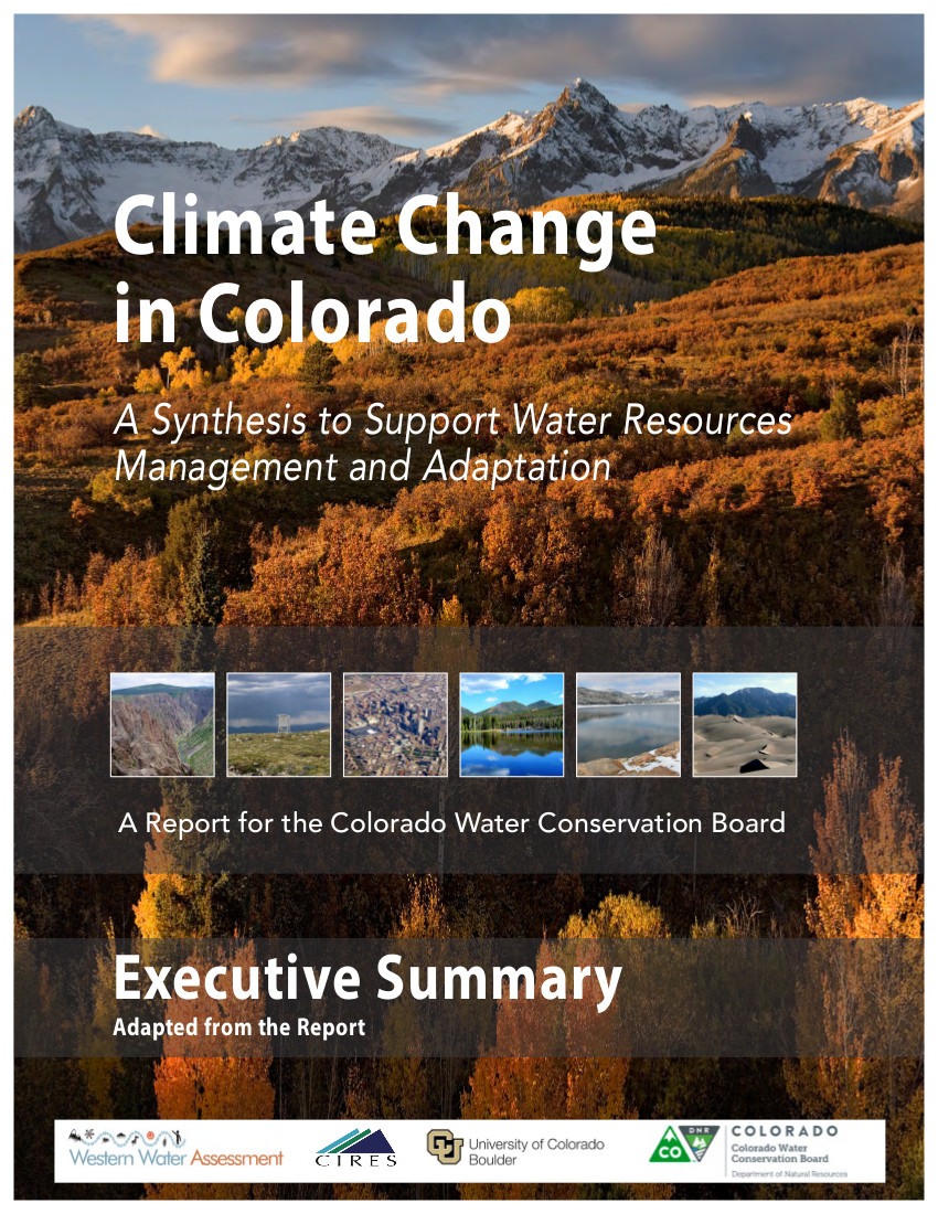
From the Colorado Independent (Bob Berwyn):
Juggling Colorado’s already stretched water resources is going to get even tougher in the decades ahead. Rising temperatures will cut river flows and increase demand from thirsty plants and towns, a new state report concludes, projecting that average temperatures across Colorado will climb by at least 2.5 degrees Fahrenheit in the next 35 years, and by much more than that if there are no cuts in greenhouse gas emissions.
The report, released last month by the Colorado Water Conservation Board, outlines clearly how global warming has already affected water resources in Colorado:
Warmer temperatures and other changes (dust on snow) mean that snowpack is melting earlier, on average, by one to four weeks compared with 30 years ago. This creates a strain for farmers and other users who draw water directly from rivers. Colorado has seen no long-term increase or decrease in total precipitation or heavy rainfall events. Climate models are split about Colorado’s future precipitation, showing a range of possible outcomes from a 5 percent decrease in precipitation to an 8 percent increase by midcentury. Climate models tend to show a shift toward higher midwinter precipitation across the state. Hydrology models show a wide range of outcomes for annual streamflow in Colorado’s river basins, but an overall tendency towards lower streamflow by 2050, especially in the southwestern part of the state. The part about more midwinter snow is not a typo. The best available information now suggests a slight boost in precipitation from December through February, but whether that comes as snow or rain depends very much on elevation, and how fast the overall climate warms, said the Western Water Assessment’s Jeff Lukas, the main author of the report.
If some high country ski resorts see a bump in snowfall, you can still blame it on global warming. Warmer air holds more water vapor, and even in warmer climate, those clouds will give up some of that moisture as they’re forced up over the high peaks of Colorado.
The models don’t suggest any other big changes in other parts of the climate system (for example the lifting mechanism that forces air to rise and condense moisture), said Colorado State Climatologist Nolan Doesken.
“Unlike other parts of the country where temperature is the primary limiting factor for snow, we will still be plenty cold enough throughout the midwinter season,” Doesken said.
Climate Nuance
Teasing out a global warming signal in mountain ecosystems isn’t easy. There’s huge year-to-year variability, even without any changes forced by heat-trapping pollutants like carbon dioxide and methane. Tree ring records spanning thousands of years show longer and drier droughts than anything we’ve seen, but scientists are convinced they’re starting to see a pattern.
“There are so many nuances about this, but we’ve got a signal emerging from noise,” said Lukas. “The precipitation record is still noisy, but we can’t discount that we’re seeing a trend caused by anthropogenic global warming … The global models just don’t get it right for Colorado. It’s pretty difficult to jump from that broad scale to saying there will be more snow in Colorado,” he said.
Regardless, even if there is a bump in winter snow and rain, the warmer temperatures will suck up the moisture and then some. The end result could be a parched Colorado, unless water managers seriously pursue the path of adaptation and mitigation.
Click here to read the report. Click here to go to the website. Here’s an excerpt:
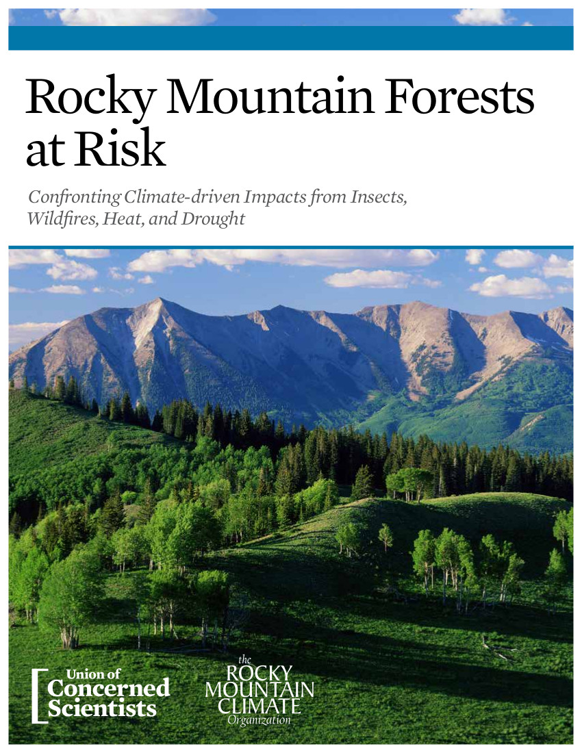
Tens of millions of trees have died in the Rocky Mountains over the past 15 years, victims of a triple assault of tree-killing insects, wildfires, and stress from heat and drought.
Global warming is the driving force behind these impacts, bringing hotter and drier conditions that amplify existing stresses, as well as cause their own effects.
If climate change is allowed to continued unchecked, these impacts will significantly increase in the years ahead, dramatically reduce the ranges of iconic tree species, and fundamentally alter the Rocky Mountain forests as we know them.
From The Mountain Mail (Brian McCabe):
Salida City Council voted 4-1 Tuesday to increase the water treatment plant improvements Phase 2 project from the original project scope of 2 million gallons to 4 million gallons.
Councilman Hal Brown voted no, and Councilman Mike Bowers was absent. The upgrade will cost the city an additional $20,000 from the capital fund reserves, plus $6,000 to replace the windows. Brown said he could not vote for the increase because it will use reserve funds.
More infrastructure coverage here.
Click here for all the inside skinny from Western State Colorado University. Here’s the pitch:
Wildness rests upon willfulness – the willfulness of land, of people, of species, and of places. Environmental historians such as Roderick Frasier Nash, and environmental activists such as Dave Foreman, have long reminded us the Old English word wildeor-ness was based upon “Wil: willful, self-willed; Doer: beast, animal; Ness: place.” So what does it mean for a place to be “self-willed”? What kind of human and ecological work cultivates such willfulness, such autonomy and agency, such wildness? What is the human place in producing wildness? Is “the working wild” the path to Headwaters Elder Devon Pena’s challenge that we have and can become a “keystone species?”
This year’s Headwaters Conference, our 25th program, will explore the intersection of wilderness, working landscapes and environmental-justice perspectives on self-willed lands, self-willed species and self-willed communities in the Headwaters. In this year, the 50th anniversary of the Wilderness Act, we will go beyond the wilderness debate to discover how Headwaters communities are innovating upon the concept of wildness, while closing the political, philosophical and geographical gap between work and the wild.
More education coverage here.
I posted 75 photos on Facebook in the album "2014 CWC Summer Conference" http://t.co/1l4huKMPfY
— CO Water Congress (@COWaterCongress) September 16, 2014

From The Grand Junction Daily Sentinel (Gary Harmon):
A Colorado pikeminnow has become the first of its species to make its way up the fish passage in the Colorado River to the Grand Valley Water Users Association roller dam, where it was collected and released to travel upstream, possibly to the top of the pikeminnow’s range near Rifle.
The fish, which turned up Friday in the collection area of the roller dam, is significant for several reasons, said Dale Ryden, project leader for the U.S. Fish and Wildlife Service’s Colorado River Fishery Project.
“Now we know that this particular species can negotiate this particular fish ladder” at the roller dam, Ryden said. “The efforts we have put in to provide passage for this species in the Colorado River upstream of Grand Junction have not been in vain.”
The fish passage was completed in 2004 and cost about $4.8 million to build.
The fish, which was about 23 inches long and of indeterminate sex, was estimated to be 5 to 8 years old. It was untagged, meaning it is was wild.
No other pikeminnow have negotiated the path to the roller dam and into the fish passage yet, though three other species — razorback sucker, bonytail and humpback chub — already have done so, Ryden said.
The so-called 15-Mile Reach of the Colorado River through the Grand Valley up to De Beque Canyon is already well-known as an important spawning and breeding area for the pikeminnow, the largest of the minnows and the top native predator of the Colorado River through its range.
The pikeminnow’s travels into the waters above the diversion dam, which was completed in 1916, will give biologists a chance to learn more about how the fish might have lived in the upper reaches of the range before the diversion dam and the Price-Stubb dam below cut off their access upstream, Ryden said.
It’s hoped that other pikeminnow will follow the example of this first one and find their way through the diversion dam and into the 40 to 60 miles of potential native range unseen by the species for nearly a century. Before the dams were built, only cooler water near Rifle limited the range of the fish.
“Fish tend to find other fish, it’s the nature of the river,” Ryden said, adding that if the fish found on Friday remains above the roller dam, it might emit pheromones that would attract others of its species to higher reaches of the river.
While this marks the first time a pikeminnow has negotiated the Grand Valley fish passage, pikeminnow long ago mastered the Redlands fish passage on the Gunnison River in Grand Junction.
As many as 17 pikeminnow have passed through that collection facility so far this year, exceeding the previous annual high of 12.
“We’re seeing a slug of young fish that are being collected for the first time,” Ryden said.
The Fish and Wildlife Service also has noted more than 20 razorback suckers passing through the Grand Valley fish passage. The previous high in any year was two.
More endangered/threatened species coverage here.


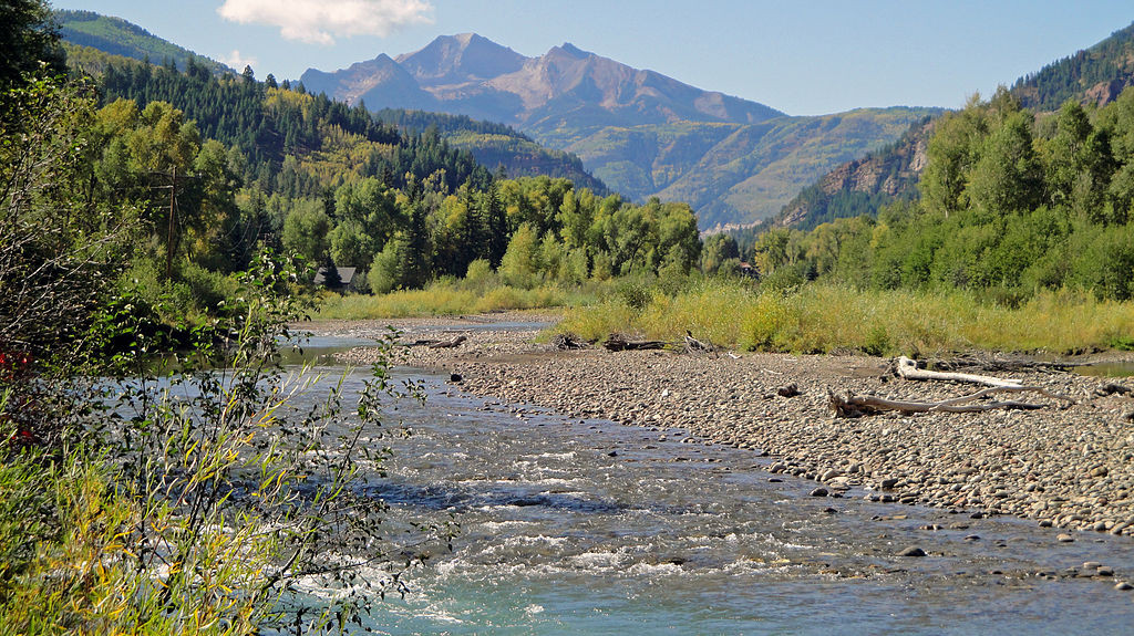
From The Grand Junction Daily Sentinel (Dennis Webb):
Some local residents think protection of the Crystal River south of Carbondale under the Wild and Scenic Rivers Act is the next logical step for sparing it from dams and diversions.
The effort will likely face political challenges, as was evidenced Monday by the reservations expressed about it by Dave Merritt, a board member of the Colorado River Water Conservation District. That district and the West Divide Water Conservancy District previously abandoned most water rights, including ones for large reservoirs, in the face of opposition including a legal challenge by Pitkin County.
Nevertheless, “We see the Crystal River still as an important water supply for western Colorado,” Merritt said during a Garfield County commissioners meeting.
He worries that a wild and scenic designation by Congress would permanently prevent not just further water development of the river but also other activities such as more home construction in the valley.
But Crystal Valley resident Bill Jochems said a dam would be a far more permanent action than wild and scenic designation, which occurs through an act of Congress and Congress could later undo.
“This act has great flexibility,” he said, adding that advocates have a “barebones” goal of preventing dam-building above where irrigation diversions already occur several miles south of Carbondale.
Advocates say the designation wouldn’t affect state or local land-use regulations.
In 2012, the Crystal made American Rivers’ annual America’s Most Endangered Rivers list. That was after the river district and the West Divide district had agreed to concessions that included giving up some conditional rights for two large reservoirs on the river while still envisioning smaller ones in the valley. The rights for the big reservoirs dated to 1958, and one would have required flooding the village of Redstone.
The U.S. Forest Service has found the river eligible for wild and scenic designation, based on the river’s free-flowing status, valley historical attractions such as the Redstone Castle and the former coke ovens in Redstone, the stunning beauty of the valley especially during fall-color season, and other historical, recreational and aesthetic attributes. The Forest Service now is in what Kay Hopkins of the White River National Forest said is the long process of determining whether the river is suitable for such a designation.
“It’s where all the hard questions are asked” about whether designation is best or there are some other ways to protect it, she said.
“It really is an outstanding river and what we’re doing is try to preserve it as it is today for future generations, and that’s what the act is all about,” she said.
Click here to read the newsletter. Here’s an excerpt:
CLIMATE CHANGE IN COLORADO
In August, Western Water Assessment released its updated “Climate Change in Colorado” report, a sythensis of climate science relevant for water resources planning. According to the report, even if precipitation doesn’t decline, higher temperatures could still increase stress on water resources. You can find the report here.WATER SUPPLY UPDATE
A wet monsoon season following a solid winter snow season has left most of the Upper Colorado River Basin with above-average precipitation for the current water year, and prospects for additional moisture over the next 3 months are good.
Extraordinary aurora photos from the U.S. and around the world http://t.co/R5fMl03Vde pic.twitter.com/VLmT2gSl6h
— Washington Post (@washingtonpost) September 13, 2014
Click here to visit the Colorado Foundation For Water Education website for their radio program look back at the September 2013 flooding.
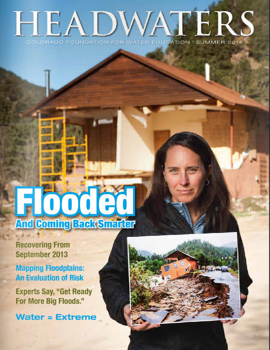
Click here to go to the CFWE website and the Summer 2014 issue of Headwaters “Flooded and Coming Back Stronger” for their flood reports. Here’s an excerpt (Caitlin Coleman):
For northern Colorado, September 2013 was hell. At the time, the National Weather Service called the flooding “biblical.” For those impacted, it might as well have been. Farmers watched herds of mice scurry across wet fields to reach higher ground and avoid inundation—the first plague. People, too, struggled to survive and protect family, animals and property. Those assisting with emergency response and rescue efforts lived on adrenaline, Snickers bars and without sleep for days. It felt like the rains would never stop. Ten lives were lost. Hell.
Although total economic losses and flood-related damages won’t be known with certainty for years, state officials are estimating the tally at around $3.4 billion. In the end, that number will include damage to agricultural land and production, tourism losses, as well as impacts to homes, businesses, roads and more.
Repairs and rebuilding continue, but less than a year out it’s too soon to say what Colorado will remember and learn from the event and what will become lore.
The storm began forming along Colorado’s Western Slope on September 7. The previous week was record-breakingly hot and dry, says Nolan Doesken, Colorado’s State Climatologist. Tropical moisture heading north from the Pacific coast of Mexico had swept across the desert Southwest, targeting western Colorado. Kevin Houck, chief of watershed and flood protection for the Colorado Water Conservation Board, recalls emailing Doesken after checking the precipitation forecast, hopeful for a few inches of rain—drought relief. At the time, Doesken told him not to get too excited, these storms rarely pan out.
By September 9, that moisture moved to the Front Range. As rain showers began to fall, another mass of soggy, humid air was sweeping up from the Texas Gulf coast pumping water in like a pipeline, says Mike Chard, director of the Boulder Office of Emergency Management. The dew point was 67 degrees, and “everything was just right for this to turn into a bad day,” Chard recalls.

From the Denver Business Journal (Cathy Proctor):
“It’s been a year since the floods destroyed a great deal of our infrastructure throughout the affected areas,” said David Eves, president and CEO of Public Service Co. of Colorado, Xcel’s subsidiary in the state.
“At the time we were dedicated to taking care of our customers gas and electricity needs as quickly and safely as possible. The aftermath was about rebuilding the system and that required a great deal of planning, construction and collaboration with local and state agencies to accomplish, the bulk of which will be completed this year,” Eves said.
Xcel on Friday put out numbers for its recovery efforts:
$13 million spent to repair damage to the utility’s natural gas system; $2.5 million spent repairing the electrical system, with more spending expected; $10,000 contributed to the Foothills United Way Flood Relief to cover administrative costs for processing and collecting donations More than 400 Xcel employees worked to get the natural gas distribution system operational 37 days after the rain started. It was ready for full winter service by Oct. 31, 2013; About 70,000 Colorado customers that lost electric service, most were restored within 48 hours. More than 4,100 customers were without natural gas service, due to damage on the system.
Restoration of the natural gas system included replacing about 10 miles of plastic and steel pipe, and replacing about 900 of the 1,300 natural gas meters that were inspected.Xcel also started a program to help customers rebuild and recover from the floods, called the “Bonus Rebates for Colorado Flood-Affected Customers.” The program, to date, has paid out more than $90,000 to 374 customers. About half the money was spent on high-efficiency furnaces and hot water heaters, Xcel said. The rebates went to customers in Boulder, Longmont, Lyons, Estes Park and other areas, Xcel said.
What hurricane Odile means for the Southwest, Colorado: http://t.co/dvjNznhEuE #nmwx #azwx #cowx pic.twitter.com/pzUmIYgXTa
— Weather5280 (@weather5280) September 16, 2014
Lots of reds, yellows and orange in NASA's new August global temp map … #globalwarming pic.twitter.com/0iJ691f7U6
— Bob Berwyn (@bberwyn) September 16, 2014

From the Fort Collins Coloradoan:
State officials will host a meeting in Fort Collins on Wednesday, Sept. 17, to discuss the Colorado Water Plan with residents of the South Platte River Basin, the massive watershed that encompasses Fort Collins and the entire northeast corner of the state.
The water plan is a statewide initiative to prepare for long-term water use in Colorado, where burgeoning populations along the Front Range will tax Western Slope reservoirs in years to come. Colorado’s Rocky Mountains are the headwaters for most major rivers in the West, and provide water to 18 other states. But next to Arizona, the state is one of the last in the West to develop a statewide plan for water use.
A final draft of the plan is due to Gov. John Hickenlooper by December. However, Nov. 1 is the deadline for gathering public comment on the water plan. The plan is divided into basins, and each basin will have its own plan.
The Fort Collins meeting will address plans and concerns for the South Platte River Basin, and all residents from Fairplay to Julesberg are welcome to come. The meeting will be from 1 to 4 p.m. at the Fort Collins Senior Center, 1200 Raintree Drive. There is another meeting in Denver on Oct. 1 for the South Platte basin.
From the Cortez Journal (Jim Mimiaga):
The question is how to keep farming viable while covering a Front Range domestic supply gap expected to be between 350,000 and 500,000 acre-feet per year?
The state’s eight water basins are negotiating solutions that will culminate in a Colorado Water Plan for future management due out late next year.
Front Range metro suppliers say the solution is diverting more water from Western Slope rivers and reservoirs via the 22 transmountain diversions already in place.
But state water districts west of the Continental Divide are calling foul, and have calculated that if Front Range residents stop watering their thirsty Kentucky Bluegrass lawns it will be enough to make up the supply shortage.
“Ninety percent of domestic water use — your kitchen, bathroom, showers — makes it back to the river systems and reservoirs through return flows. It has less water-supply impact than watering lawns, which absorb 70-80 percent of it,” said Mike Preston, general manager for the Dolores Water Conservation District.
Preston is also chairman of the Southwest Water Roundtable, tasked with forming a local strategy for responsible water use and policy.
“The state proposes a 60-40 standard for domestic water consumption, 60 percent for in-home and 40 percent for outdoor lawns to better conserve water for ag production and population growth,” he said “But we’re getting a lot of pushback from Front Range water suppliers who are accustomed to the 50-50 ratio now.”
For domestic water obtained via transmountain diversions, the suggested ratio is 70 percent indoor use, and 30 percent outdoor use.
Furthermore, increasing transmountain diversions have far-reaching consequences. Siphoning off more Western Slope water to the Front Range threatens the state’s water-contract obligations for downstream states like Arizona, Nevada and California who depend on Colorado River basin water stored in Lake Powell and Lake Mead.
“They’re watching our water polices, more than we look at theirs,” Preston said. “Colorado is the headwaters for a lot of their supply.”
Meanwhile Western Slope water — especially the Blue Mesa Reservoir complex, near Gunnison, and Wyoming’s Flaming Gorge Reservoir — are looked at with envious eyes by Front Range water districts.
But the massive reservoirs are mainly designed to store water for contractual delivery to Lake Powell and Lake Mead relied on by Lower Basin states.
Colorado is entitled to 51 percent of Colorado River basin water above Lees Ferry, Ariz. Once it is diverted to the Front Range, it is lost to the Colorado River system, eventually draining east toward the Mississippi River.
To make a dent in unsustainable water demand in Fort Collins, Denver, and Colorado Springs, they should become more like Las Vegas, local water officials say.
The city’s successful lawn conservation program has vastly reduced water consumption, and includes strict drought-resistant landscaping regulations for future development…
“Front Range water district plans all include transmountain diversion as the solution,” Preston said. “We’re saying it won’t be considered until you get more aggressive about domestic conservation by limiting outdoor watering.”
More education is needed about the importance of responsible water management, said Bruce Whitehead, of the Southwest Water Conservation District.
“Many people don’t have a clue about the state water plan or the issues we’re facing,” he said. “We have a lot of work to do in our basin to educate the constituency.”
More Colorado Water Plan coverage here.

From The Pueblo Chieftain (Chris Woodka):
A $939,000 contract for utility location and land rights acquisition support for the Arkansas Valley Conduit has been awarded to MWH Americas by the Bureau of Reclamation. The contract is another step toward the eventual construction of the conduit, which will bring clean drinking water to 50,000 people in 40 communities east of Pueblo.
Work begins this month and is expected to take one year to complete.
The 130-mile-long pipeline will be built from Pueblo Dam to Lamar, with spurs to communities along the way, including St. Charles Mesa, Avondale, Crowley County, Otero County, Bent County, Lamar and Eads in Kiowa County.
“The objective of this contract is to provide Reclamation with utility locations, current ownership information, legal descriptions and encumbrances affecting the parcels along the route,” said Jacklynn Gould, Eastern Colorado Area Manager for Reclamation.
The contractor also will prepare a preliminary land acquisition plan and update GIS data.
The Arkansas Valley Conduit is part of the Fryingpan-Arkansas Project, authorized in 1962. It was never built because of the expense, now estimated at $400 million. A 2009 federal law authorized revenues from Reclamation contracts as a repayment source for the conduit, however.
The Southeastern Colorado Water Conservancy District is the local sponsor of the project.
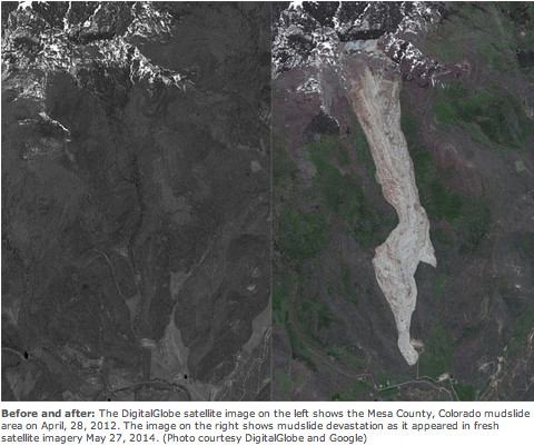
From the Glenwood Springs Post Independent (Chad Thatcher):
As first responders to arrive at the slide on May 26, Frank Kochevar, Mesa County Public Works’ professional surveyor, and Tim Hayashi, Mesa County Public Works’ engineer and field commander, remember getting a glimpse of the area, and uttering the words, “Oh, my God.” No one had seen a slide of this magnitude — ever.
After nearly three and half months, Hayashi and Kochevar traveled to the slide dozens of times, setting up surveillance equipment, clearing roads, building trails and juggling 14 different organizations that have a stake in the outcome. From CMU and U.S. Geological Survey (USGS) geologists to landowners and Mesa County officials, a rather fragile landscape has created a thoughtful and organized crew of individuals working every day to better understand the event.
Sensitive monitors have recorded every movement around the slide, evacuation routes have been established, maps have been rewritten, gas lines have been shut down, roads reconstructed, cell lines installed and lines of communication set up. All this collaboration is designed to answer the one question on everyone’s mind: Will a landslide of this magnitude happen again? And if so, where, when and how?
After meeting with a host of experts, the definitive answer is yes, there will be another landslide on the Mesa — but as to when, that is all speculation. No one could have predicted the West Salt Creek Slide, its size and destructive force. However, in the aftermath, all eyes turn to similar terrain that flanks the side of the Grand Mesa.
Rex Cole, a geology professor at Colorado Mesa University, explained the unique geography and the complicated history that encompassed the slide area. The region has a long history of landslides; in fact, landslide zones surround the entire Grand Mesa. Gravity has been exerting its force on the mesa for eons, contributing to a form of erosion called mass wasting. The term used by geologists describes the movement of soil and rocks down the side of a mountain. A quick examination of the slide area shows mostly a greenish shale rock from the Green River formation, a kind of fine-grained sedimentary rock that literally crumbles in your hand. It’s not the best foundation, especially on the side of a slope.
During the two days prior to the incident, over an inch of water fell in the area. Jeff Coe, with USGS, said the rain added to the “juiciness” of the slide. Adding an intense rain on snow event to an unstable surface creates the perfect recipe for a landslide.
Geologists are still concerned about the West Salt Creek slide area, especially with the formation of a new 190-acre-feet lake at the headwall. The lake continues to fill and is expected to breach the spillway this spring. At that point the entire headwall has the potential to erode away, sending a wall of water down the slide path. Residents of Collbran are concerned about the influx of water, but Bill Edwards of the U.S. Forest Service concluded that the amount of water is consistent with spring runoff and the watershed should absorb the excess. Still, nearby residents and businesses are preparing for the inevitable, the re-emergence of West Salt creek somewhere along its historic path.
Jerald Hawkins, owner of the property, and Oxy, an oil and gas exploration company, are taking a proactive stance by digging a potential drainage where the creek can safely enter and reconnect with its historical waterway. The slide path narrowly missed the Oxy gas pad located on the Hawkins property. Oxy immediately responded to the incident by shutting down all activity at the site.As first responders to arrive at the slide on May 26, Frank Kochevar, Mesa County Public Works’ professional surveyor, and Tim Hayashi, Mesa County Public Works’ engineer and field commander, remember getting a glimpse of the area, and uttering the words, “Oh, my God.” No one had seen a slide of this magnitude — ever.
After nearly three and half months, Hayashi and Kochevar traveled to the slide dozens of times, setting up surveillance equipment, clearing roads, building trails and juggling 14 different organizations that have a stake in the outcome. From CMU and U.S. Geological Survey (USGS) geologists to landowners and Mesa County officials, a rather fragile landscape has created a thoughtful and organized crew of individuals working every day to better understand the event.
Sensitive monitors have recorded every movement around the slide, evacuation routes have been established, maps have been rewritten, gas lines have been shut down, roads reconstructed, cell lines installed and lines of communication set up. All this collaboration is designed to answer the one question on everyone’s mind: Will a landslide of this magnitude happen again? And if so, where, when and how?
After meeting with a host of experts, the definitive answer is yes, there will be another landslide on the Mesa — but as to when, that is all speculation. No one could have predicted the West Salt Creek Slide, its size and destructive force. However, in the aftermath, all eyes turn to similar terrain that flanks the side of the Grand Mesa.
Rex Cole, a geology professor at Colorado Mesa University, explained the unique geography and the complicated history that encompassed the slide area. The region has a long history of landslides; in fact, landslide zones surround the entire Grand Mesa. Gravity has been exerting its force on the mesa for eons, contributing to a form of erosion called mass wasting. The term used by geologists describes the movement of soil and rocks down the side of a mountain. A quick examination of the slide area shows mostly a greenish shale rock from the Green River formation, a kind of fine-grained sedimentary rock that literally crumbles in your hand. It’s not the best foundation, especially on the side of a slope.
During the two days prior to the incident, over an inch of water fell in the area. Jeff Coe, with USGS, said the rain added to the “juiciness” of the slide. Adding an intense rain on snow event to an unstable surface creates the perfect recipe for a landslide.
Geologists are still concerned about the West Salt Creek slide area, especially with the formation of a new 190-acre-feet lake at the headwall. The lake continues to fill and is expected to breach the spillway this spring. At that point the entire headwall has the potential to erode away, sending a wall of water down the slide path. Residents of Collbran are concerned about the influx of water, but Bill Edwards of the U.S. Forest Service concluded that the amount of water is consistent with spring runoff and the watershed should absorb the excess. Still, nearby residents and businesses are preparing for the inevitable, the re-emergence of West Salt creek somewhere along its historic path.
Jerald Hawkins, owner of the property, and Oxy, an oil and gas exploration company, are taking a proactive stance by digging a potential drainage where the creek can safely enter and reconnect with its historical waterway. The slide path narrowly missed the Oxy gas pad located on the Hawkins property. Oxy immediately responded to the incident by shutting down all activity at the site…
In general, unless gravity mysteriously disappears, landslides will continue to shape the landscape; and wherever humans interact with these landscapes, disaster can occur. For example, the state of Washington’s deadly Oso landslide killed 43 people on March 22, taking out an entire rural neighborhood. Despite its isolated location, tragedy also struck at the West Salt Creek slide. While investigating a small landslide that had blocked an irrigation canal, Wes Hawkins, 46, Clancy Nichols, 53, and his son, Danny Nichols, 24, were evidently in the path of the second and more destructive landslide. Their bodies are still missing…
As Grand Mesa residents prepare for winter and the eventual spring runoff, experts are also looking at positive aspects of the West Salt Creek slide. As Bill Edwards of the U.S. Forest Service points out, from an ecological perspective, area experts have an amazing opportunity to observe and monitor the area as life again takes hold. Already flowers and plants are starting to take root in the area.
From The Denver Post (Nancy Lofholm):
Up close, the grayish, topsy-turvy surface of Colorado’s largest recorded rock avalanche yields small surprises that hint at the land as it was before: snail shells, Douglas fir cones, charcoaled wood, nubs of aspen shoots and intermittent clods of rich, brown topsoil.
They’re all tucked into 50 million tons of rock and debris that rumbled and raced down this draw on the Grand Mesa on May 25.
This week, many of the experts who have been studying the slide, along with the county and national officials who have been monitoring it and the landowners impacted by it — one an uncle of a slide victim — walked out on this slide together for the first time.
They shared a thought as they picked their way over the slide’s steep, spongy surface in a whipping wind: They never expect to see anything of this magnitude in this state again in their lifetimes.
“In Colorado, this is historically unprecedented as far as I can tell,” said Jeff Coe, a geologist with the U.S. Geological Survey.
Those watching for the next move of this mass often refer to it as a living entity — a “monster” that churned up pulses of pulverized rock, twisted giant chunks of earth and now hides an underbelly of soaked earth beneath slide matter as deep as 130 feet.
It has proven its danger, even in a sparsely populated area of ranch houses and hayfields, by claiming the lives of Wes Hawkins, Clancy Nichols and Danny Nichols.
The slide’s continuing danger is focused in the 190-acre lake that formed when a massive block of cliffside fell and tilted backward turning into an iffy dam for runoff. The lake is already leaking. That is evident in the smaller seep ponds forming below.
There is no dispute among the experts that the lake will double in size next spring and overflow.
“It is not a question of if, but when,” said Tim Hayashi, an engineer for Mesa County and the field commander for the dozen-plus agencies still studying and monitoring the slide.
When the lake tops, it could form a new creek channel down the middle of the slide. Or it could flow out haphazardly over the the giant hummocks of earth in the middle of the slide path and start a new debris movement. That movement could take debris into an irrigation canal or a creek. It could end up on an Occidental Petroleum Corp. well pad that the initial slide barely skirted.
Occidental is preparing for any slide movement in that direction by abandoning part of the well pad closest to the slide and building berms and a new drainage to divert water or mud.
The need for such measures is underscored by other factors pointed out by the experts this week.
“Those escarpments are a danger, ” said Colorado Geological Survey geologist Jon White as he pointed to a tree-lined ridge that hides large swaths of fractured earth. That could be the next to go.
Coe said the increasing incidence of rain falling on snow — a phenomenon he thinks contributed to this slide — causes snow to melt faster and puts more pressure on unstable rock formations. He expects more of that in more locations with climate change.
For now, monitors on the slide have allowed those living in the vicinity to breath a little easier this summer. But whether the devices will stay put during the winter snows is in doubt.
Hayashi said if the monitors are knocked out, he will climb back up this slide in the early spring even though the danger will be greatly magnified then.
“No one wants to be there,” Hayashi said. “But you just have to do it.”
From The Denver Post (Nancy Lofholm):
Government, industry and scientific experts who recently toured the West Salt Creek rock avalanche area agree that fracking is not to blame for setting off the deadly slide.
The fact that the craggy lower edge of the rock avalanche on the Grand Mesa towers over and curves around a drilling pad where Oxy USA has a gas well is not relevant, they say.
“From my perspective, there is absolutely no evidence fracking was involved in any way,” said U.S. Geological Survey geologist Jeff Coe, who has spent the past 3½ months mapping and studying the slide.
“It was a rain event,” said Jon White, with the Colorado Geological Survey, as he looked out over the mass of pulverized rock that roared down a draw May 25 and buried three local men.
Oxy narrowly escaped the complicated and unusual problem of having a drilling operation buried by tons of debris. But the company, which has wells dotting the Plateau Creek area on the mesa, did not escape claims that drilling activities had caused the slide.
When the first aerial images of the rock avalanche were released, the blaming fingers of online observers immediately pointed at the drilling pad at the toe of the slide. The proximity was taken as proof that fracking — drilling and injecting fluid into the ground at a high pressure to release natural gas — had made the area unstable and caused 39 million cubic yards of earth to move.
Rex Cole, a Colorado Mesa University geology professor who has studied the formations of the Grand Mesa for four decades, underscored the government geologists’ opinions with charts and maps.
They depict the mesa as a sort of layer cake with 10 million-year-old lava rock capping softer slanted layers of shale, basalt and limestone.
Cole described the Green River layer of rock where the slide occurred as being “squishy” and easy to break off and cave in with heavy rain and seeping groundwater.
“There is a lot of science pointing in the other direction,” he said of claims that fracking caused the earth to move. “You get it wet, and down it comes.”
Fracking in the slide area ended in 2008. It took place in the Williams Fork formation more than a mile below ground and more than 2 miles from where the slide began, near the mesa’s top.
There were no injection wells associated with the drilling in that area. The fracking fluids for Oxy’s wells were stored in tanks.
About 300 to 500 gallons of that fluid was hauled out in trucks in the wake of the slide, said Chris Clark of Oxy USA.
Oxy moved equipment on the well pad and abandoned the end of the pad closest to the slide. Clark said the company is building a berm and drainage to prepare for the possibility that the slide could let go again in the spring.

Here’s the release from the Environmental Protection Agency:
Today the U.S. Environmental Protection Agency (EPA) continues its commitment to improving America’s drinking water by providing over $8 million to create two national centers for research and innovation in small to medium sized drinking water systems.
“These centers will help to develop innovative and practical solutions for challenges faced by smaller drinking water systems, which make up the majority of public water systems in the United States,” said Lek Kadeli, Acting Assistant Administrator for EPA’s Office of Research and Development. “Providing cost effective solutions to help these systems deliver safe, high quality drinking water will help improve the health, economy and security of our nation’s communities.”
The recipients are the University of Colorado Boulder’s Design of Risk Reducing, Innovative Implementable Small System Knowledge (DeRISK) Center [ed. emphasis mine], and the University of Massachusetts Amherst’s Water Innovation Network for Sustainable Small Systems (WINSSS) Center. These two EPA funded centers will develop and test advanced, low cost methods to reduce, control, and eliminate groups of water contaminants that present challenges to communities worldwide.
Ninety seven percent of the nation’s roughly 160,000 public water systems serve fewer than 10,000 people each. These drinking water systems face many obstacles including limited resources, aging infrastructure, and complying with a variety of regulations These centers will help strengthen the technical, managerial, and financial capacities of drinking water providers throughout the country. Both centers will collaborate with a range of stakeholders to support problem-oriented research on groups of water contaminants and their origins. This research marks a move towards developing trans-disciplinary results that will be nationally acceptable and applicable.
These grants, part of EPA’s research on safe and sustainable drinking water, support the development of water clusters– networks of businesses, researchers, and others involved in water technology. Colorado and Massachusetts are both home to water cluster organizations. These organizations are leading the way in developing cutting-edge technologies and bringing them to the market, where they can solve water challenges that threaten health and daily activities while promoting technological innovation and economic growth.
More water treatment coverage here.

From The Colorado Statesman (Ernest Luning):
“High and dry is not a water plan,” Beauprez responded to a question about water storage. “We simply must put a shovel in the ground.”
Saying he supports building water storage, no question, Beauprez contended that regulation gets in the way of building the projects Coloradans need. “A governor needs to lead on behalf of the people to eliminate regulatory hurdles, not add to them,” he said.
Hickenlooper countered that any big water storage project will take decades to complete and that “Every conversation has to start with conservation.” He also declined to take a position on the Northern Integrated Supply Project, a proposal to build reservoirs on the northern Front Range. “I’m not allowed to take — if I took a stand on NISP, it would jeopardize the entire federal process,” he said.
“On my watch,” Beauprez rebutted, “we’re going to build”

From Steamboat Today (Randy Fischer):
“Water is essential to Colorado’s quality of life and economy, but our ability to maintain those values will be challenged by a growing population, increasing demands for water, and limited supplies of this precious resource.”
These words appear on the Colorado Water Conservation Board’s website, describing the need for and purpose of the proposed Colorado Water Plan, which is to be drafted by the end of 2014 under an executive order signed by Gov. John Hickenlooper in May 2013.
Our goal for the water plan is to provide a path forward for providing Coloradans with the water we need in the future while seeking to maintain such divergent values as healthy watersheds and environment, robust recreation and tourism economies, vibrant and sustainable cities and viable and productive agriculture.
Colorado’s Water Plan will build on eight years of extremely valuable water supply planning work by the Statewide Water Supply Initiative, the Inter-Basin Compact Committee and the nine Basin Roundtables, one for each of the major watersheds in the state.
In 2014, the Colorado General Assembly passed Senate Bill 14-115, which also recognized the need to engage the general public in the water planning process by gathering input through a series of public meetings in all the major river basins of Colorado. SB-115 directs the legislature’s Interim Water Resources Review Committee to convene these meetings, gather public input and provide comment on the draft water plan by Nov. 1.
The next of these public meetings is scheduled for Tuesday from 9 a.m. to noon at the Bud Werner Memorial Library in Steamboat Springs. This meeting is for residents of the Yampa and White river basins. I invite and encourage all residents of Northwest Colorado, from Steamboat to Rangeley, to attend this important meeting.
The WRRC recognizes that water issues inherently involve competing values that cannot all be resolved through technological or technical fixes. Different groups bring different values to the conversation. There is no “right” way to balance these competing interests and values. Through SB-115, the WRRC is asking the public to help make Colorado’s Water Plan a better document that seeks to represent the values of all state residents.
The WRRC also recognizes that the Colorado Water Plan will identify difficult choices and tradeoffs that will need to be made to plan for and create a sustainable water future. SB-115 envisions a public process that lays out these choices and tradeoffs facing Colorado and seeks to find a way through public input to navigate the difficult issues that lie ahead.
More Colorado Water Plan coverage here.

When asked back in January of 2014 to put something together for Coyote Gulch I responded “am really short on time, my calendar frees up in March”. Well spring came and went, summer was a blur and now it is a full year since the devastating floods of September 2013. To be honest, if I wrote something in January, I think it would have been a bit pessimistic, as often times the recovery efforts were all consuming and really challenged any sense of hope. Ironic that it was the workload of the flood recovery that prevented me from writing and it was the flood that taught me yet another lesson, let things ferment and breath; given time even dire situations will eventually show you an encouraging future.
In September 2013, St. Vrain Creek experienced a catastrophic flood event which uprooted roadways, severely eroded private property, ruined homes, dramatically changed the creek corridor, and significantly damaged or destroyed public and private raw water infrastructure. Because there were limited federal, state and local jurisdictions to modify the post-flood stream condition, it became clear to many that private/public partnerships and multi-agency cooperation was critical for a successful recovery.
During the early weeks of the September 2013 Flood recovery, repairs were occurring in some locations, though in other areas property owners were asking “who is going to fix this?” The St. Vrain and Left Hand Water Conservancy District immediately recognized that the property owners’ rights needed to be a top priority. However, the scale of the flooding disaster and the interconnectivity of a living steam and associated ecosystem presented some financial and interdependency challenges. For example, it was not a stretch to imagine that there would likely be instances of individual efforts to restore specific segments of the stream that would then create problems downstream.
To minimize recovery challenges and maximize limited resources, many agencies, including Boulder County, City of Longmont, Town of Lyons, and the St. Vrain and Left Hand Water Conservancy District, promoted and implemented a strategy of collaboration. The collaboration along St. Vrain Creek started in the weeks following the flood and was quickly viewed by impacted citizens as safe, un-bureaucratic, nimble, and effective. In the months to follow, the Colorado Water Conservation Board (CWCB) provided significant financial assistance to ditch companies, in addition to numerous agencies for the furtherance of collaboration. Today these collaborative efforts are now known as “Coalitions”, and one is occurring in each of the flood impacted tributaries of the South Platte River.
Through vision, leadership, hard work, multi-agency and nonprofit support, and Ditch Company and property owner persistence the recovery effort has far surpassed the expectations of many who stood in awe of the flood ravaged areas. For example, within the boundaries of St. Vrain and Left Hand Water Conservancy District (DWR District 5) 44 of the 94 local ditches suffered damaged infrastructure from the flood at an estimated cost of $18.4M.
Through FEMA, CWCB, and grants administered by Northern Water, financial assistance was provided and as of August 28, 2014, 91% of the 44 damaged ditches are now back online, with 93% expected back online after 2014. Furthermore, many ditch companies recognized the need to rebuild their infrastructure with consideration given to the ecosystem and to design elements that would withstand future high-flow events. In the St. Vrain Creek alone, there are three new diversions that pre-flood were fish impediments, and are now fish passable, with an additional four diversions under consideration or design. Although the collaborative Coalitions didn’t lift a shovel, their collective expertise, continual internal and external communications, and identification of financial and technical resources played a key role in the recovery.
A full report and executive summary of the ditch infrastructure repairs, maps, and photos are available on the website of St. Vrain and Left Hand Water Conservancy District (http://www.svlhwcd.org), under the “2013 Flood” tab.
One year later, the work is still not complete. Each of the Coalitions are actively working on producing their own watershed specific “Master Plans” that when complete will promote a holistic healthy riparian corridor and a stream system that will be better able to handle future floods, while preserving critical infrastructure, including that used for agricultural production. If successful, these Master Plans will be embraced by affected property owners, water rights owners, ditch companies, and government agencies.
As water mangers we are trained to manage around the extremes of drought and spring runoff. September 2013 reminded me that Mother Nature is letting us manage, but when she wants to change the rules, we are pretty much at her mercy. It is said that over time memories of disasters wane resulting in some people rebuilding in a manner that does not mitigate future disaster risk. Time will tell – for now I am hopeful that our professional water community learned from this disaster and those lessons can be passed on to future water managers.
For me, the events that transpired in September 2013 will shape my approach to water management. As I look back, I am confident the water system we rebuilt is reflective of our societal values and a wonderful legacy for future caretakers of our natural resources. Everyone involved in this recovery should be very proud to be in a profession that cares so deeply about “managing” a resource that provides for the incredible quality of life we all enjoy. I will just continue to be mindful who is really in charge.
Below is a gallery of then and now photos of the irrigation infrastructure along the St. Vrain River. Credit to the ditch companies.


Here’s a presentation from Boulder County: 2014-08-05_ByTheNumbers_FinalWithTalkingPoints
Finally, here’s a map of the river with the locations of enhanced fish passage noted.
More St. Vrain River coverage here

From the Colorado Springs Post Independent (Matthew Schniper):
…The Wilderness Society notes a new poll of 11 Western states that “shows strong support for taking action on legislation that would reinvest a portion of rents and royalties from renewable energy development on public lands to conservation activities.”
That legislation is the Public Lands Renewable Energy Development Act (H.R. 596/S. 279), being pushed for a vote this fall.
More conservation coverage here.
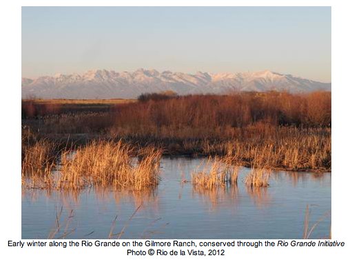
From the Valley Courier (Craig Cotten):
State water administration still evolving
By CRAIG COTTEN Division Engineer Colorado Division of Water Resources
This is the thirteenth article in the series from the Rio Grande Basin Roundtable regarding the formation and implementation of the Basin Water Plan. VALLEY For more than 140 years, Colorado has used a system of water allocation known as the prior appropriation system.
Prior appropriation refers to the concept that those that put water to use first are entitled to get their water first during periods of water shortage, or put more simply, “First in Time, First in Right.” The Colorado Division of Water Resources is the sole state agency that is empowered to administer surface and groundwater to ensure that the prior appropriation doctrine is enforced.
The administration of water has been occurring in this area since before Colorado became a state. During the gold rush days when Colorado was still a territory, miners established ‘miners’ courts’ to handle disputes. Many times these disputes centered around water and who was entitled to use the water when there was not enough for everyone. It was during this time that the concept of prior appropriation really came into being in Colorado. In 1876 when Colorado became a state, the idea of a water administration system based upon the prior appropriation doctrine was enshrined in its constitution .
With the establishment of the position of water commissioners in 1879, Colorado became the first state in the nation to provide for the distribution and administration of water by public officials. In 1881, the legislature established the Office of the State Irrigation Engineer, known today as the State Engineer’s Office or the Division of Water Resources. In 1887 the legislature created a position called the superintendent of irrigation for each of the seven main river basins, or divisions, in the state. This position is now known as the Division Engineer.
For the first nearly 90 years of water administration by the state, water administration was restricted mainly to surface water. This changed in 1969 with the passage of the Water Rights Determination and Administration Act. This act required that groundwater be integrated with surface water into the prior appropriation system, and allowed the State Engineer to develop Rules and Regulations to administer groundwater use. In 1972, the State Engineer issued a moratorium on new wells in most parts of the San Luis Valley, and in 1981 that moratorium was expanded to prohibit new wells in all parts of Division 3. In 1975 the State Engineer developed groundwater rules for Division 3, the drainage basin of the Rio Grande. These rules stated that well owners had to replace the depletions due to their well pumping or they would be shut down. Obviously this threat of shutting down many wells in the San Luis Valley did not please the well owners, and a period of nearly 10 years of litigation ensued. In 1985, with an agreement between the parties to the lawsuit, the rules were dismissed . In their place the water users agreed that the Closed Basin Project would be used to offset the depletions to the rivers caused by the wells. The agreement worked fairly well until the late 1990’s and the drought years of the early 2000’s , when it was apparent that more formal regulation of groundwater was needed in Division 3.
One of the hurdles to groundwater regulation in the San Luis Valley has always been the lack of a good understanding of the aquifers and their interaction with the rivers and streams. In 1998 the legislature passed legislation that directed the State Engineer to begin a study of the aquifers of Division 3. This study became known as the Rio Grande Decision Support System (RGDSS), and is an ongoing study that has shed a great deal of light on the aquifers. In that same year the legislature also directed the State Engineer to begin developing rules to govern new withdrawals of water from the confined aquifer based upon information gathered from the RGDSS study. These rules were formally adopted by the State Engineer in 2004 and prevented any increased withdrawals of groundwater from the confined aquifer. After a lengthy trial in Alamosa, the rules were approved by Judge Kuenhold in November 2006. The ruling was appealed to the Colorado Supreme Court, and in 2008 the Supreme Court upheld the rules.
As part of the need to get more data on groundwater usage, the State Engineer established the well measurement rules in 2005. These rules require all large capacity wells, and some smaller wells, in Division 3 to be equipped with flow meters . The meter readings are collected a minimum of once per year and are being used to get a detailed description of the water use by well, and the total groundwater usage in the San Luis Valley . This is very important for the RGDSS model as well as for the impending groundwater rules.
In 2008 the State Engineer established an Advisory Committee in order to assist him in developing new groundwater use rules for existing groundwater uses. It is anticipated that these rules will be finalized this fall. Once the rules are in place, they will require that most large capacity wells in Division 3 replace their depletions to the streams and ensure that the aquifers remain sustainable. Owners that do not replace the depletions from the use of their wells and take steps to bring the aquifers back into a sustainable situation will have their wells shut down.
As water becomes a more and more precious commodity , there is need for increased administration of that water. This is to ensure that the water is being used by the people entitled to use it, that it is being used for its intended purpose, and that there is no injury to someone else’s water rights due to actions by another water user.
More Colorado Water Plan coverage here.

From the Pagosa Springs Sun (Ed Fincher):
According to 18th century Scots poet Robert Burns, “The best laid plans of mice and men often go awry.”
Pagosa Verde owner Jerry Smith must have this line of poetry running through his mind all the time when dealing with the federal, state and local government, and Monday night’s meeting of the Pagosa Area Geothermal Water and Power Authority was probably no exception.
The authority, which consists of three town councilors (David Schanzenbaker, John Egan and Mayor Don Volger), the three county commissioners (Michael Whiting, Steve Wadley and chairman Clifford Lucero) and one at-large seat held by Mike Alley, just barely had enough members show up at Town Hall to achieve a quorum for the meeting.
Town Manager Greg Schulte, along with County Administrator Bentley Henderson and County Attorney Todd Starr, acts as staff for the authority, began by giving some background information for the people in the audience who may not have attended the authority’s previous meetings.
The original intent of the authority, as spelled out in the agreement between the town and the county, was to enter into an agreement with Pagosa Verde to form a separate entity — Pagosa Waters LLC — as a public/private partnership.
Pagosa Waters would then consist of three people: one appointed by the authority, one appointed by Pagosa Verde and one at-large member. The point being, this arrangement would ensure joint ownership of the project between the two local governments and Pagosa Verde, while at the same time allowing the project to be managed by a full-time, working board instead of part-time government volunteers.
According to Schulte, a wrinkle in the plan occurred because of a recently awarded grant from the Colorado Department of Local Affairs worth nearly $2 million. Archuleta County was the official applicant for the grant because DOLA only deals with local government bodies, not private companies.
The $2 million grant from DOLA counts as matching funds for a $4 million grant from the U.S. Department of Energy, which was awarded earlier this year to Pagosa Verde. However, since Pagosa Verde is a privately owned, for-profit company and Pagosa Waters LLC would be a public/private partnership, DOLA had concerns about the legality of Archuleta County funneling its funds into the project.
Schulte then alluded to a meeting held last week involving himself, town attorney Bob Cole, Starr and another attorney, Russ Dykstra, who has some experience with similar situations.
Starr then took over the briefing, explaining, “He has been involved in some very large public/private partnerships … and his suggestion was that, from everybody’s stand-point, an LLC is probably not the form we want to take. Some sort of concession agreement is the best way to do it because we can take care of all of Jerry’s requirements and all of our requirements.”
More Pagosa Springs coverage here.
Three Chinook Spotted Above Glines Canyon; First Salmon Return to the Upper Elwha in 102 Years
http://t.co/SK3vN6rgYa
— Reclamation (@usbr) September 13, 2014
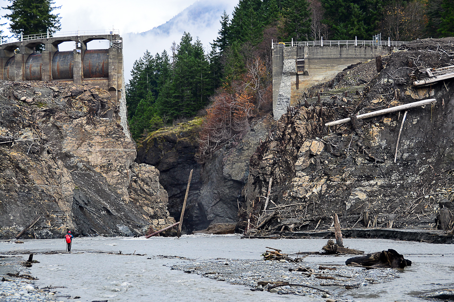
Three #Chinook Spotted Above Glines Canyon; First #Salmon Return to Upper Elwha in 102 Yrs http://t.co/jgjsylTeN4 pic.twitter.com/WaypGaMfWa
— Solomon David (@SolomonRDavid) September 12, 2014
Keep an eye on this aurora modeling page tonight for aurora visibility in CO/UT. #cowx #utwx #aurora http://t.co/aE69P3dfQy
— NWS Grand Junction (@NWSGJT) September 13, 2014
After yesterday’s flare, time to read up on the REALITIES of how a flare can affect Earth. http://t.co/HaqKRCsh3U pic.twitter.com/f8V74Fx2hZ
— NASASunEarth (@NASASunEarth) September 11, 2014
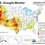
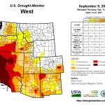
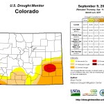
Click here to go to the US Drought Monitor website. Here’s an excerpt:
Summary
Over the last seven-day period, an active pattern has helped to bring precipitation over several of the drought regions in the country. As the monsoon season continues and has been aided by tropical moisture coming up the Gulf of California, portions of the Southwest continue to see significant moisture. Areas in and around the Phoenix metro area recorded up to 6 inches of rain on the morning of September 8. Substantial flooding took place in many parts of the area. Several days of rain and thunderstorms helped to bring some relief over the southern Plains where August was especially dry. In the Texas panhandle, central Oklahoma, and eastern Kansas, 1.5-3.0 inches of rain was recorded this week. The upper Midwest also had a good week of rain where 2-3 inches fell over portions of northern Wisconsin, northern Michigan, and central Minnesota. A change in the pattern over the southeastern United States allowed for a return of moisture into the region, with significant rains, up to 6 inches this week, over areas from northern Florida up the coast and into the Carolinas. Temperatures varied across the country this week, with above-normal temperatures over the eastern third and west coast of the United States. Below-normal temperatures were recorded over much of the central to southern Plains as well as the central to northern Rocky Mountains…The High Plains
Mainly dry conditions over most of the region this week, with only portions of Kansas, central Nebraska, and North Dakota recording more than 200 percent of normal precipitation. Temperatures were generally below normal over Nebraska, Kansas, and northern Wyoming and into the western Dakotas. Improvements were made in Nebraska and Kansas as there was little support for D1 in the eastern portions of both states. In southeast Nebraska and eastern Kansas, D1 was improved, while improvements to D1 were also made in north central into western Kansas. In southwest Nebraska, D0 was also improved as the current pattern of above-normal moisture continued. Southeast Kansas saw D2 removed this week as well…The West
Warm temperatures over most of the region were experienced during the week, with only areas of Idaho, Montana, eastern Washington, and eastern Oregon having temperatures below normal this week. The monsoon moisture over the southwest continued and was amplified with some tropical moisture this week. Flooding rains over the Phoenix metro area along with significant moisture over much of the central portion of the state did help to ease drought concerns, and a full category improvement was made where the greatest precipitation was observed…Looking Ahead
Over the next 5-7 days the precipitation pattern looks to be quite active and encompassing the eastern half of the United States. The greatest precipitation amounts are anticipated over the Midwest, southern Plains, and Southeast, with projected amounts of up to 3.50 inches. The moisture plume over the Southwest looks to shift east over the next week with amounts of up to an inch in New Mexico, west Texas, and Colorado. Temperatures will be cooler than normal over the High Plains, with maximum temperature departures of 12-15 degrees below normal forecast over Nebraska, South Dakota, and eastern Wyoming.The 6-10 day outlook shows the cooler-than-normal temperatures more likely over the eastern half of the United States. The best chances for above-normal temperatures are centered on the Great Basin and western United States as well as most of Alaska. The projections show that most of the Midwest, New England, Plains, northern Rocky Mountains, and southern Mississippi Valley have the best chances for below-normal-precipitation. Above-normal precipitation chances are greatest over the southeast and southwestern United States as well as southern Alaska.

From the Glenwood Springs Post Independent (John Stroud):
The importance of green lawns to maintain quality of life and urban home values was heard alongside that of maintaining river flows for the Western Slope’s recreation-based economy in comments to the Colorado Water Conservation Board Thursday.
“Back yards are our recreational amenity,” Mark Pifher of the Front Range Water Council said during testimony before the CWCB on the draft Colorado Water Plan in Glenwood Springs as part of a two-day meeting that continues today at the Hotel Colorado.
Pifher also took to task Winter Park real estate broker Dennis Saffell, who cited statistics from Grand County that suggest riverfront properties sell for 134 percent more than other types of residential property, and even properties with a view of a river are 24 percent more valuable.
“It’s really important to keep our rivers viable economically, not just for the recreational aspects but for the entire economy that supports our communities,” Saffell said. “Rivers create a lifestyle, attract tourists and attract the people that live here.”
But aggressive conservation measures aimed at limiting outdoor water use in Front Range cities can have the effect of lowering real estate values in those areas, countered Pifher, who pointed out that outdoor irrigation makes up only 4 percent of consumptive water use in the state, according to statistics referenced in the draft water plan.
Joe Stibrich, representing the city of Aurora Water Department, suggested that, just as anglers and whitewater enthusiasts expect the state’s water plan to preserve the recreation experience in the mountains, urban dwellers have a right to expect a “reasonable residential experience.”
That includes reasonably irrigated lawns, public parks and sports fields, and golf courses, he said.
Statewide conservation measures also need to be considered on equal footing with viable alternatives to meet Front Range water needs, including new supply development through future trans-mountain diversions, he said…
“Water utilities do recognize the importance of healthy rivers and ecosystems,” Stibrich said. “But it’s equally important to maintain an urban environment with healthy landscapes.”
The debate pointed up the difficult task before the CWCB to deliver on Gov. John Hickenlooper’s directive to present a statewide water plan by December that addresses the often divergent views between the Western Slope interests and those of Front Range communities.
The first-ever statewide water plan is intended to address a significant gap in the amount of water needed to meet growth projections, especially on the Front Range, and what’s now available through both in-basin and trans-basin diversions.
But a key goal is also to protect healthy river flows on the Western Slope, including in the Colorado River Basin where members of the basin roundtable have recommended a strong emphasis on conservation in the water plan, along with opposition to any new trans-mountain diversions.
At some point, “the line has to be drawn … enough is enough” when it comes to Front Range water diversions, said fishing guide Jack Bombardier, owner of Confluence Casting in Gypsum in his testimony before the water board.
Bombardier was part of a coalition of river recreation business owners and enthusiasts, along with conservation groups, who spoke during the Thursday session. The coalition cited a study that shows river-based recreation in Colorado generates $9 billion a year and is responsible for 80,000 jobs.
“We all have skin in the game,” Bombardier said. “But we’re approaching a crossroads. The whole western [Colorado] ecosystem and economy hinges on healthy rivers.”
Water Conservation Board member Patricia Wells, representing the city and county of Denver, said one of the state’s recreational amenities that is reliant on water is missing from the equation in reference to those statistics — golf courses.
She requested that golf be mentioned in the section of the water plan that addresses recreational and environmental projects.
Wells also challenged speaker Annie Henderson, representing the Upper Colorado Private Boaters Association in Glenwood Springs, when she made reference to “wasteful and irresponsible water use” in relation to the need for better conservation measures to help protect the Western Slope’s quality of life.
“Quality of life exists in urban areas too,” Wells said. “Different people use water in ways that are valuable to them.”
Here’s some video from KREXTV.
More Colorado Water Plan coverage here.
From the Public News Service (Tommy Hough/Chris Thomas):
Outdoor business leaders and conservationists are joining forces to urge Colorado to prioritize river-based recreation in the state’s upcoming water plan.
As the Colorado Water Conservation Board meets Friday [September 12, 2014] to discuss the first statewide water plan, the conservation and business coalition will press the state to rely on data collected around the Colorado River Basin to ensure enough water remains in rivers to sustain the region’s $12 billion recreation economy.
Nathan Fey, director of Colorado River stewardship programs at American Whitewater, said he thinks the draft plan fails to make some crucial connections.
“We’re not seeing the state water plan make that effort and really invest in improving our understanding of river health and recreational health,” he said.
Fey said he finds that missing connection odd, since the science on which his coalition bases its concerns isn’t anything new.
“There are nearly four decades of science that have been developed around how to define stream flows for recreation,” he said, “and to understand the relationship between flow and recreation quality.”
The state’s draft water plan currently includes major trans-mountain diversions, and a movement of water across the Rocky Mountains for the state’s thirsty Front Range cities such as Denver and Boulder. Fey predicted that moving water on a speculative basis would jeopardize the health of many of the state’s most beloved rivers without considering greater conservation measures as an option.
“We think that the water plan should prioritize conservation and other concepts like reuse and water sharing,” he said. “That is much more palatable than these new, large-scale projects that are divisive and really destroy our river systems.”
The same need to prioritize river health, Fey said, will be on the agenda for the regionwide Colorado River Basin Study, a major federal document that will impact western rivers for decades to come.
“What really needs to happen next, because it’s not just Colorado,” he said, “is our neighboring states in the basin make a concerted effort to identify how much water we need to keep in our rivers to sustain a recreation economy.”
According to Fey, outdoor recreation access and quality, along with overall environmental health, are among the top concerns of Colorado residents – and one of the key advantages for Front Range-area businesses in attracting new employees.
More Colorado Water Plan coverage here.
I made the mistake of checking my Twitter feed during the early morning last September 12. All sorts of trouble was brewing in the streams flowing out of the Front Range canyons. Aurora took a pounding too as did locations in the Arkansas Basin. I couldn’t get back to sleep.
Please take the time to read the stuff below (Click through to read the full articles that I’ve excerpted). We have some great writers covering water in Colorado.
From Physics Today (Samantha Tushaus):
Atmospheric scientists, their eyes on recent catastrophic weather events, are newly motivated to study orographic precipitation. Orographic precipitation—rain and snow caused or influenced by topography—is a key component of the hydrologic cycle, and scientists have long understood that the amount and distribution of precipitation depends upon topography and atmospheric characteristics.
However, orographic precipitation also contributes to natural disasters, including flash floods. In September 2013, Boulder, Colorado, and surrounding communities in the Rocky Mountain foothills experienced rainfall so torrential as to trigger flash floods, with water levels rising dramatically over only a few hours. The floods were accompanied by heavy debris and mud, which swept away vehicles, roads, and buildings.
Here’s a photo gallery of before and after photos from the Fort Collins Coloradoan.

From The Denver Post (Colleen O’Connor and Yesenia Robles):
Araceli and Rito Romero lost everything in the flood that swamped their mobile home in Evans, then were cheated out of $10,000 they paid to buy another trailer home.
Manuel Hernandez, an immigrant with a work permit, struggled to find housing for his family after their trailer home was destroyed, and now is paying twice as much to rent a space in a mobile home park.
John Vega managed to rebuild his mobile home in Milliken, complete with new floors and walls, but now lives in limbo, uncertain whether or not the mobile home park will be closed down.
“I told FEMA, if we have to move out of here, you’re going to have to move me out because I ain’t got money to move out,” he said on a recent afternoon, as his wife stood in their cheerful new kitchen making tamales for their granddaughter’s Quinceañera celebration.
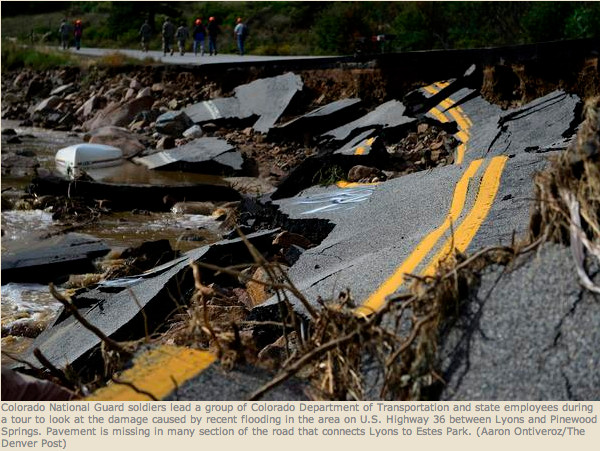
From 9News.com (Maya Rodriguez):
September brings painful memories for thousands impacted by last year’s floods. For one business in Lyons, the flood did virtually no physical damage, but still took a major toll. Now, though, it’s a different story at The Stone Cup, a café and restaurant on High Street.
“We’re right back on top of things again,” said Sam Tallent, one of the co-owners.
Nearly one year ago, things were different here.
“It was a challenge having no business for a couple of months,” The Stone Cup co-owner Mindy Tallent said.
The Tallents said it has been a long year for the town and its businesses.
“We don’t really have any other options, so we just have to persevere,” Mindy Tallent said.
The Stone Cup looks to be in great shape because the flood waters never touched it. Water swept past it onto other, lower-lying areas. Rebuilding isn’t just about the progress you can see, though. There are scars in Lyons, even for those who didn’t suffer any physical damage to their home or business.
The café and restaurant remained closed for months because there were so few customers in town. They didn’t reopen full-time until December. What got them through it, the Tallents said, was a $55,000 federal loan from the Small Business Administration.
“You think about the importance of businesses to our communities, it’s employment, it’s economic activity and, in the case of the Stone Cup, it’s a gathering place,” said SBA Regional Administrator Matt Varilek.
The SBA said that in Boulder County, it received more than 2,678 loan applications after the floods and approved 68 percent of them– at a total of more than $65 million. More than $14 million of that, went to businesses in Lyons. As for the 32 percent of applications that were denied, the agency said those applicants couldn’t prove they would have the ability to repay the loan.
The Stone Cup is one of the fortunate ones, though. The Tallents just hope other businesses in town can also bounce back enough to bring Lyons back, too.
“I want to very seriously believe that,” said Sam Tallent, “because I think the vast majority of us want it back like that.”
The SBA said it has provided more than $109 million in low interest loans in Colorado since the flooding. Those who get a loan have up to 30-years to pay it back.
From MarketPlace.org (Grace Hood):
One of the hardest-hit centers following the 2013 Colorado flood was the 2,000-person town of Lyons. Key pieces of the town’s infrastructure, like sewer, water and gas lines, were severely damaged. Fast-forward a year, the town is still working on a list of 87 projects ranging from park and riverbank repair to bridge rebuilding.
You wouldn’t be able to tell by taking a walk down Main Street. In the town’s busiest corridor, you can barely see signs of the flood. But almost everyone in town has a story — including Connie Sullivan, owner of the St. Vrain Market.
From KUNC (Grace Hood):
After waters washed over Boulder, Larimer and Weld counties during the September flood, many started to rebuild. Others haven’t been able to go back.
The easiest way for Ed and Sarah Egloff to describe their lost home in the Big Thompson Canyon is to tell you what remained on the property afterward.
“The only thing that was in the place where I thought it should have been was the ground rod for the electrical service,” said Ed.
From the Fort Collins Coloradoan:
It’s been a rough year for Rough’n It Wright. The floor of the small, brown cabin named for the families that owned it for decades has sagged down and been left exposed since the Big Thompson River tore away the ground supporting it last September. Some of the cabin’s contents slid out through the gap and were swept away. Other furnishings are still there: A washer and dryer hang on by power cords and a hot air ventilation pipe; mattresses cling to beds tilted toward the river. The cabin looks like a shoebox, with the bottom peeled back from one corner. A beige carpet covers much of the slatted wooden floor, the edge of which rests on jagged white and gray boulders.
Perched under a towering canyon wall halfway between Drake and Estes Park along U.S. Highway 34, the cabin has become an icon of the 2013 flood and the challenges residents and government officials face a year later.
While progress has been made toward recovering from the devastating deluge, years of planning and construction work remain. Natural and bureaucratic barriers must be hurdled by agencies attempting to rebuild roads and bridges and families trying to rebuild lives.
The owner of Rough’n It Wright, Lynda Wright of Cypress, California, has not been to the cabin since the flood. Members of her extended family were in the cabin and the cottage next door — Linger Longer — during the flood and were rescued by the local volunteer fire department. Wright has only seen pictures of the devastation. But what she’s seen has made her determined to rebuild Linger Longer.
“When I look at the pictures, I don’t see what remains,” she said. “I see what it was before.
“I can visualize every single person I have known and loved who has been at that cabin over the years. And I am not going to give up on it.”

From KUNC (Nathan Heffel):
One of the more striking images during the September flood was of inundated oil and gas pads, washed out earthen berms and overturned storage tanks. In all, over 48,000 gallons of oil and condensate spilled. While changes have been made in the industry to prepare for another flood, so far, they’re strictly voluntary.
Matt Lepore, director of the Colorado Oil and Gas Conservation Commission, said that while there were some visible spills, the situation could have been much worse.
“Frankly [it was] a relatively small number of spills, a relatively small volume of oil and gas that was released,” he said.
From his standpoint, the industry performed well during the flooding, closing off wells — a process known as shutting in the well — that were at risk of flood damage before waters rose. The agency is looking at possible rule changes for sites near rivers and streams including anchoring storage tanks, installing impenetrable liners, and erecting fences. But for now, they’re strictly recommendations and no new rules have yet been approved.
Even so, some companies are making changes on their own accord. For example, in areas prone to flooding, earthen berms have been replaced with metal ones, which perform better in flooding.
“Earthen berms tended to wash away and potentially lead to greater impacts,” Lepore said.
The agency has considered making that a rule change, and has talked with the industry about doing so. Lepore said the change would most likely be accepted without much resistance.
“Honestly I don’t think the rule making would be too controversial,” he said. “I think most operators see the wisdom of the practices that we’ve recommended.”
Doug Hock, a spokesman with Encana Corporation, which has wells throughout Weld County, including some in low-lying areas, said he agreed with the recommendations laid out in the COGCC post-flood report. Although none of them are binding yet.
“These are recommendations that align with our best practices and you know, again we look at this, it really goes along with the measures we took,” Hock said.
The flood, and the subsequent damage to their wells, cost the company several hundred thousand dollars Hock said. Overall the procedures in place at the affected well sites worked. This included the automatic shut-in of at-risk wells.
However, Sam Schabacker, director of the Colorado branch of Food and Water Watch, a group that believes hydraulic fracturing should be banned, said more needs to be done than leaving the industry to self regulate.
“There are no rule changes, there was no legislation,” Schabacker said. “So Coloradans haven’t been protected from future flooding activities in any meaningful way.”
“There are no new rules and regulations saying, for example, that you shouldn’t build in a flood zone, you should not be drilling in a place that typically floods and has historically done so in the state. So I think that it’s really astonishing to me, and us at Food and Water Watch, that after this unprecedented flood that nothing has resulted, no changes.”
Encana’s Hock said the company anchored tanks to concrete and installed impervious liners for spill mitigation – something he calls “best practices,” before the flood.
To Schabacker, the potential for future spills caused by flooding is still too large.
“[We risk] tens of thousands of gallons of potentially toxic liquid washing down rivers where we grow a large percentage of our food crops, where we have people who live downstream from these areas, and there are over 6,000 almost 6,000 wells that are built in these floodplain areas, there are more being permitted every day, and there have been no changes,” Shabacker said.
Discussions over regulations and rule changes as a result of the flood could come up at the next scheduled Colorado Oil and Gas Conservation Commission hearing – including requiring metal berms to be installed around flood prone wells. However, COGCC’s Lepore said that’s not officially on the agenda.
From the Loveland Reporter-Herald (Jessica Benes):
One year after the 2013 Front Range flood, which hit Northern Colorado on Sept. 11-12, 2013, work is still in progress to repair local natural resources.
The Poudre Wilderness Volunteers are hosting a work day Saturday and Sunday to continue rebuilding efforts of the North Fork Trail by Glen Haven and mark the one-year anniversary of the flood.
The initial assessment of damage on forest infrastructure and facilities in Roosevelt and Arapaho National Forests — which include Larimer and Boulder counties — was estimated at $17.8 million, according to Reghan Cloudman, spokeswoman for the Canyon Lakes Ranger District of the U.S. Forest Service.
And about $950,000 was done in damage to Larimer County parks and open spaces, according to Travis Rollins, open space operations manager for Larimer County Natural Resources.
Approximately half of the work has been completed on Larimer County open spaces. FEMA paid for 75 percent of the total, the state paid 12.5 percent and Larimer County paid 12.5 percent.
Larimer County residents have contributed hundreds of hours helping the natural resources department with flood cleanup and repairs.
The U.S. Forest Service is not eligible for FEMA grants. The agency allocated $5.2 million of its budget in 2014 to recovery and will spend all but $600,000 of that this fiscal year.
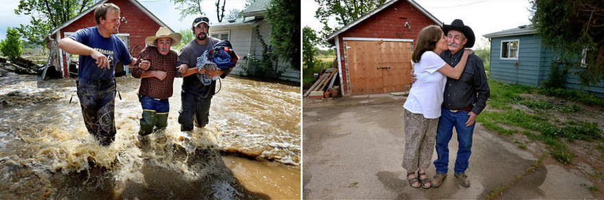
Here’s a photo gallery of before and after photos from The Denver Post.
From The Denver Post (Electa Draper):
While area landfills still are receiving flood debris a year after the storms, some water experts believe too much might have been cleaned up and could in time hurt the rivers.
The piles of muck-coated possessions of residents hit hardest by the September 2013 floodwaters mostly are gone from view, but every big rain that scours a river channel pries loose more debris.
Shards of metal, splintered wood, fractured drywall, ripped carpet, fence pickets and tattered plastic still can be loosed after a year of being encased in riverbeds somewhere upstream.
More than 1,800 homes were destroyed and more than 28,000 others damaged, according to the Colorado Recovery Office.
“We’re about 99 percent done with household debris, but it’s still an ongoing cleanup effort,” said Dan Gudgel, division manager for Waste Connections, which runs the Erie landfills. “You can still see debris in rivers and streams.”
“It’s hard to put a good number on the amount of flood debris,” Gudgel said, “but I would estimate we’ve seen 50,000 tons” at the Erie landfills, the epicenter of flood-debris disposal.
For Coloradans in love with their state’s beauty, the September 2013 floods revealed an uglier side of nature. Trees snapped and stripped clean like toothpicks, broken branches, gnarled roots and heaps of sand, gravel and rock look nasty lodged around a favorite walking trail, swimming hole or backyard.
Yet there is trash, and then there is debris that is a critical piece of river restoration.
“I’m very concerned that we have hauled too much away,” said Chris Sturm, the Colorado Water Conservation Board’s river-channel expert. He’s the coordinator of the interagency Stream Team that’s guiding watershed restoration.
“The river is a puzzle that the flood took apart,” Sturm said. “If you want to put it back together, the last thing you should do is throw out pieces of the puzzle.”
He believes some area landowners and officials might have overreacted and removed too much sediment, wood and rock.
Large woody debris can be removed from the channel but stockpiled nearby, he recommends.
“Let’s use that wood and sediment to reshape and restabilize the channels,” Sturm said.
In some places, they already have.
Along the St. Vrain Greenway in Longmont, unsightly piles of wood, sand and rock remain at random intervals along the creek banks. It’s part of the plan.
“You should keep what you can and reuse it,” said Longmont Public Works director Dale Rademacher. “It saves on transportation costs.”
It also saves on importing new materials to shore up banks.
Julie McKay, who heads Boulder County’s comprehensive creek planning, said some materials — colored rocks that are not native or natural components of local basins — have been brought in by some landowners.
Yet, McKay said, she understands the urgency that private residents and officials felt immediately after the flood to shore up banks and to clear the channels ahead of the spring runoff.
“A lot of county time and resources were spent on hazardous woody debris removal,” McKay said. “We were very oriented to what would happen in the spring if we didn’t. We’ve exhaled now. … Now it’s a planning phase.”
As to whether it’s safe yet to go back in the rivers for recreation, it’s a personal choice stream by stream.
Chrystal DeCoster lives in Lyons and has observed how new storm events deliver small reminders of the past devastation. She’s also seen disappointed people dragging their punctured inner tubes out of the St. Vrain.
DeCoster’s advice: “I wouldn’t stick a toe in the water yet.”
From the Longmont Times-Call (Whitney Bryen):
Nearly a year after the flood that ravaged the small town [Lyons], French still flashes back every time his phone rings to the 1:30 a.m. phone call on Sept. 12, 2013, telling him to evacuate his home.
A nearly empty medicine bottle still causes anxiety as French remembers the fear that he faced, afraid he wouldn’t have access to his medication. Thinking about the neighbors and friends who helped him get the medication he needed while he was displaced from his home is his only relief.
Even small things, like a dripping faucet or static on the television that sounds like rushing water can lead to sleepless nights and bouts of depression, French said.
“The flood affected me in my head, triggering all of these new things that are making me paranoid and terrified all the time,” French said. “But it also affected me in my spirit.”
Since the flood, French has been visiting free and low-cost, drop-in counseling sessions being offered to flood survivors searching for relief. He continues to see local psychotherapist Linda Weber, who moved her practice to Lyons part-time to reach more flood survivors.
French said that overall his fears seem to be subsiding, but as the anniversary approaches, he is concerned that the memories will set him back again.
Here’s a photo gallery of then and now photos from Colorado Public Radio.
From The Denver Post (William Porter):
On a sunny, late-summer day, Eric Skokan strolled among the rows of his farm northeast of Boulder, proudly pointing out some of the vegetables he grows for his two restaurants and various farmers markets: spinach, fennel, six types of basil, cabbage, broccoli, celery, and an experimental stab at sesame plants.
Forty yards away, two sows sprawled on their sides in a fallow patch, their piglets nursing away. Beyond them, corn stood higher than the proverbial elephant’s eye. In all, a scene of bucolic ease and nature’s largesse.
“It’s been a great season,” said Skokan, chef-owner of Black Cat Bistro and Bramble & Hare, his farm-to-table restaurants in downtown Boulder. “Everything is looking gorgeous. Vivid green, the kind of fields that make you feel like a farmer.
“Good, steady rains. Warm days that weren’t too hot. Prime weather.”
Skokan, who started farming in 2007, knows something about weather, both the prime kind and wrath-of-nature punishing.
From The Denver Post (John Aquilar):
Karen Little finds herself in the same bind as thousands of other Coloradans hit by historic flooding a year ago — no flood insurance and a dire need to manage the aftermath of the state’s most costly and widespread natural disaster.
“It leaves me with nothing,” said the 62-year-old bookkeeper, whose home near La Salle was decimated by an overflowing South Platte River last September. “I can’t fix my house because I don’t have the money and I don’t qualify for anything.”
While Little got $16,000 from the Federal Emergency Management Agency to help with rental assistance and house repairs, it wasn’t enough to make her house habitable again. She doesn’t make enough money to qualify for a U.S. Small Business Administration loan.
“I didn’t know I needed flood insurance,” Little said.
That’s not unusual given the fact that drastic flooding events are not common in Colorado, said Rocky Mountain Insurance Information Association executive director Carole Walker. Homeowners either don’t know about flood coverage, which is underwritten by the National Flood Insurance Program and administered by FEMA, or they choose to forgo it.
“Many people probably said, ‘I’m not in a high flood risk area’ and didn’t have it,” she said. “Colorado has not had this type of widespread, catastrophic loss from flooding.”
Only 24,000 individuals and businesses in the state have flood insurance policies — totaling $5.6 billion in coverage.
From The Greeley Tribune (Kayla Young):
A new, more secure irrigation system in Platteville has become the silver lining for 14 agricultural areas in northern Colorado that had a diversion dam wiped out by last September’s floods.
Although few designs could have withstood such a large-scale weather event, developers of the new Beeman/Meadow Island structure say the modern system would have prevented some of the damage from the 2013 flood.
For starters, ditch operators will no longer need to enter the South Platte to manually install stop logs that manage water flow. Lowering the floodgates will now be as easy as pulling up a phone app, said Robert Eckman, vice president of Obermeyer Hydro Inc.
This equates to quicker response times and less risk for workers.
“The ditch operator can now lower or raise the gate remotely using an application on his cell phone,” explained Eckman at a visit to the reconstructed irrigation facility yesterday.
Obermeyer Hydro Inc. designed the gate and control system for the reconstruction of the Beeman/Meadow Island No. 2 River Diversion. The Wellington-based company has installed 40 similar structures across Colorado, and currently has dozens of irrigation system projects underway across Asia, Europe and South America.
“The No. 1 thing about this system is that it is really controllable. It will maintain a constant water elevation, which is very important to pull a constant flow rate into the canal,” Eckman said. “The second thing it does is that it’s fully collapsible. In a flood, it flattens out completely and there is nothing up top that would catch the debris and worsen the flood.”
The demand for well-engineered river diversion systems has arisen from a need for safer and more manageable facilities. In Platteville’s case, the decision to implement a more advanced structure came down to practicality, said Amy Willhite, who managed the project’s funding for Beeman Irrigating Ditch & Milling Co.
“We asked if we wanted a Band-Aid approach or if we wanted to fix this thing for good. We decided we wanted to put the money into it to fix it right so that this wouldn’t happen again. We realized that this would cost a lot of money. Luckily, the Colorado Water Conservation Board came to the rescue with the emergency loan program,” Willhite said.
In total, the Colorado Water Conservation Board provided $28 million in low-interest loans and grants to rebuild across the flood area. The Beeman/Meadow Island project received $2 million, approximately $1.5 million of which has been used to date. This low-interest loan will be repaid over a 30-year period.
To contribute to engineering costs, the facility also received $50,000 in grant money through Northern Water, said Amy L. Johnson, a Northern Water project manager.
“Northern Water is the fiscal agent for a $2.55 million grant from the Colorado Water Conservation Board. Northern Water and CWCB worked through an application process and developed this grant program and awarded 107 different grants through two cycles,” Johnson said. “In the case of this project, the Beeman Irrigating Company received two grants, both in cycle one and cycle two.”
Johnson said many of the grant requests received by Northern Water were similar to that of Beeman Irrigating Company. Ditch operators needed help repairing diversion structures and clearing out debris in time for the new irrigation season in August.
In a sense, the timing of September’s flood was fortunate for farmers. Although flooding caused extensive crop losses, ditch operators were given enough time to regroup before the 2014 season, said John R. Stulp, a water policy adviser to Gov. John Hickenlooper.
“If we were ever to have a disaster, September was the best time to have it because immediately a lot of companies had financing lined up, and grants from the state to start the assessment and engineering. Then they were able to work through the fall, winter and early spring,” Stulp said.
He added, “By the time late winter and early spring came and the water started flowing, many were back in operation. Over 90 percent have been reconstructed so they are operational. By next spring, nearly 100 percent of those that choose to be reconstructed will be back in business.”
Mike King, executive director of the Colorado Department of Natural Resources, said the remaining repairs will require more careful planning.
“Those are areas where we had the river change channels and the community is undergoing a discussion about where the river should go,” King said.
Through collaborative efforts, King said Colorado has been able to respond quickly to natural disasters and develop action plans.
“It’s awfully hard to have the human resources infrastructure in place and trained because this may not happen again for 100 plus years. What I think we did have in place was a dedicated staff that was willing to learn. I think we’ve all come out of this with a better understanding,” King said.
He added, “We looked to other states that had been through natural disasters and we mobilized very quickly. We looked at all of the hurricane damage along the East Coast to get debriefings on how to go to the feds for resources.”
For a state that has suffered an onslaught of natural disasters in recent years, King emphasized the importance of utilizing human resources to implement rapid response measures.
“Unfortunately, it’s something we’ve gotten far too good at in Colorado. In three and half years of Governor Hickenlooper’s administration, we’ve had 13 natural disaster declarations, which is unprecedented nationwide,” King said.
He added, “Whether it’s droughts or fires or floods — and we’ve had all three — we have become very proficient at making sure resources that are available on the federal level are mobilized and put on the ground for Coloradans. That is absolutely something we’ve become more proficient at than we would like.”
From KRDO (Jay Polk):
It was nearly one year ago that parts of Southwestern Colorado were hit hard by flooding rains. Water invaded homes along Cheyenne Creek and the neighborhood around it was declared a disaster area.


