
Click here to go to the US Drought Monitor website. Here’s an excerpt:
Summary
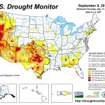
Over the last seven-day period, an active pattern has helped to bring precipitation over several of the drought regions in the country. As the monsoon season continues and has been aided by tropical moisture coming up the Gulf of California, portions of the Southwest continue to see significant moisture. Areas in and around the Phoenix metro area recorded up to 6 inches of rain on the morning of September 8. Substantial flooding took place in many parts of the area. Several days of rain and thunderstorms helped to bring some relief over the southern Plains where August was especially dry. In the Texas panhandle, central Oklahoma, and eastern Kansas, 1.5-3.0 inches of rain was recorded this week. The upper Midwest also had a good week of rain where 2-3 inches fell over portions of northern Wisconsin, northern Michigan, and central Minnesota. A change in the pattern over the southeastern United States allowed for a return of moisture into the region, with significant rains, up to 6 inches this week, over areas from northern Florida up the coast and into the Carolinas. Temperatures varied across the country this week, with above-normal temperatures over the eastern third and west coast of the United States. Below-normal temperatures were recorded over much of the central to southern Plains as well as the central to northern Rocky Mountains…The High Plains
Mainly dry conditions over most of the region this week, with only portions of Kansas, central Nebraska, and North Dakota recording more than 200 percent of normal precipitation. Temperatures were generally below normal over Nebraska, Kansas, and northern Wyoming and into the western Dakotas. Improvements were made in Nebraska and Kansas as there was little support for D1 in the eastern portions of both states. In southeast Nebraska and eastern Kansas, D1 was improved, while improvements to D1 were also made in north central into western Kansas. In southwest Nebraska, D0 was also improved as the current pattern of above-normal moisture continued. Southeast Kansas saw D2 removed this week as well…The West
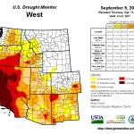
Warm temperatures over most of the region were experienced during the week, with only areas of Idaho, Montana, eastern Washington, and eastern Oregon having temperatures below normal this week. The monsoon moisture over the southwest continued and was amplified with some tropical moisture this week. Flooding rains over the Phoenix metro area along with significant moisture over much of the central portion of the state did help to ease drought concerns, and a full category improvement was made where the greatest precipitation was observed…Looking Ahead
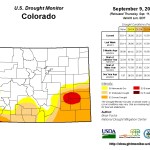
Over the next 5-7 days the precipitation pattern looks to be quite active and encompassing the eastern half of the United States. The greatest precipitation amounts are anticipated over the Midwest, southern Plains, and Southeast, with projected amounts of up to 3.50 inches. The moisture plume over the Southwest looks to shift east over the next week with amounts of up to an inch in New Mexico, west Texas, and Colorado. Temperatures will be cooler than normal over the High Plains, with maximum temperature departures of 12-15 degrees below normal forecast over Nebraska, South Dakota, and eastern Wyoming.The 6-10 day outlook shows the cooler-than-normal temperatures more likely over the eastern half of the United States. The best chances for above-normal temperatures are centered on the Great Basin and western United States as well as most of Alaska. The projections show that most of the Midwest, New England, Plains, northern Rocky Mountains, and southern Mississippi Valley have the best chances for below-normal-precipitation. Above-normal precipitation chances are greatest over the southeast and southwestern United States as well as southern Alaska.