
From the Cortez Journal (Jim Trotter):
The 2014 water year is ending gently – for Colorado, at least – as monsoonal rains and the remnants of Hurricane Odile provided enough moisture to push even the drought-stricken southeastern quadrant of the state into the 70-90 percent of normal precipitation range…
The 2014 water year is ending gently – for Colorado, at least – as monsoonal rains and the remnants of Hurricane Odile provided enough moisture to push even the drought-stricken southeastern quadrant of the state into the 70-90 percent of normal precipitation range.
It’s reasonable to think of it almost as an escape, as the state was cool and wet enough to avoid the massive wildfires of the previous two years, Black Forest in 2013 and Waldo Canyon and High Park in 2012, which claimed a total of more than 1,100 homes. There was no epic September flood this time around.
In comparison to California, which continues in the throes of devastating drought, and parts of Washington and Oregon, where millions of acres burned this water year, Colorado was downright fortunate.
“Water year” is a Western term, and the new one begins Oct. 1. It has to do with the annual cycle that includes the first snow in the high country, the accumulation of the snowpack, the spring melt and runoff, the warm summer and whatever rain might fall.
That makes today, Sept. 30, New Year’s Eve of the 2015 water year. But one can forgive residents of southeastern Colorado if they’re not breaking out the party hats. While the late rains boosted moisture totals there toward respectability, the region has been locked in various stages of damaging drought for years.
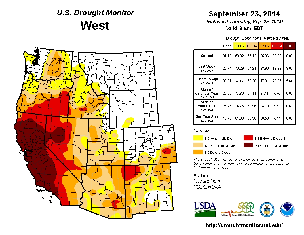
The U.S. Drought Monitor map, a product of the Department of Agriculture that is updated weekly, has five levels of dryness, from D0, abnormally dry, to D4, exceptional drought. Along with the Texas and Oklahoma panhandles, a big chunk of northeastern New Mexico and southwestern Kansas, southeastern Colorado has been firmly fixed with D3s, extreme drought, and D4s, as bad as it gets.
The modern map, in fact, has looked very similar to that of the Dust Bowl of the 1930s, even though, as of now, it has moderated a bit.
“Absolutely,” said assistant state climatologist Wendy Ryan from her office in Fort Collins. “As we were keeping track, particularly in 2011 and 2012, we started drawing comparisons to the ‘30s. It was as dry and as hot down there as the Dust Bowl.”
The visual elements were also there: Enormous dust storms, but not with the frequency or longevity of the 1930s, and tumbleweed melees that covered highways and buried barns and houses…
The lower Arkansas River basin has a long way to go before recovery to normal, Ryan said. The late season moisture has allowed farmers there to get a start on winter wheat, an endeavor that hasn’t panned out in the recent drought years. The big word is evapotranspiration, which is the soil losing moisture with no rain, and through plant transpiration, or “plant sweat.”[…]
The Four Corners were also dry this water year, as was the San Juan River basin, and the Rio Grande has been drought-plagued – which pretty much accounts for the southern tier of Colorado.
In the northern half of the state, the picture for this closing water year has been dramatically different.
The upper Colorado River basin has been flush, and beginning after last September’s massive floods, conditions along the South Platte basin have been extraordinary. Winter wheat yields on the northeastern plains were bountiful, conditions there “beautiful,” as Ryan described them.
A look at the “teacup” map published weekly by the Colorado Climate Center at Colorado State University also tells the story. Lake Granby is 128 percent of average for this time of year, 98 percent full. Blue Mesa is 74 percent full, Lake Dillon is 99 percent full. Green Mountain is at 85 percent.
All of this munificence is a matter of scale, of course. Downstream on the Colorado River, massive Lake Powell was only 51 percent full last week, and, on the other end of the Grand Canyon, giant Lake Mead has been losing water after years of drought like someone pulled the plug.
Unrelated to the Colorado River but very related to water in the West is the map published last week by the California Department of Water Resources depicting water levels in the Golden State’s major reservoirs, which ranged from 12 to 39 percent full.