From the Sky-Hi Daily News (Hank Shell):
On Aug. 27, the Colorado-Big Thompson Project was at its highest level in history for that date, said Brian Werner with Northern Water. Lake Granby was at its second highest level for Aug. 27, only beaten by Aug. 27, 1984.
“I tell people ‘you cant give away water this year,’” Werner said.
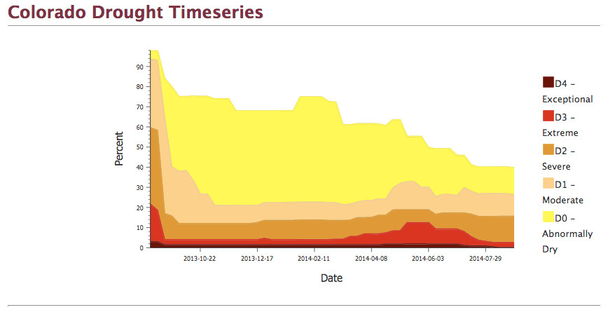
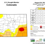
Looking at rainfall in Grand County, this year’s precipitation is somewhat deceiving. Precipitation is still below that for a normal year to date for Grand County, according to Accessweather Inc. Historically, the county has had around 7.78 inches of precipitation by this time in a normal year, though this year it has only seen about 5.58 inches.
So what’s keeping Lake Granby so full? For the answer, one needs to look across the Continental Divide.
Lake Granby, as part of the Colorado-Big Thompson Project, is actually a reservoir for Front Range water users. Water is pumped through Lake Granby, Shadow Mountain Reservoir and Grand Lake, where it flows through the Alva B. Adams Tunnel to Estes Park.
This year, an unusually wet summer on the east side of the Divide has kept Front Range reservoirs full, leaving little recourse for water in Lake Granby. Couple that with increased snowpack on the West Slope and a clarity study that has kept flows through Alva B. Adams tunnel minimal, and what’s left is a swollen lake Granby, said Kara Lamb with the U.S. Bureau of Reclamation.
“We’ve run the East Slope of the Colorado Big Thomson Project largely on East Slope water most of the year,” Lamb said.
Lamb said she wasn’t sure, but she didn’t believe the Alva B. Adams Tunnel had been run at its full capacity of 550 cubic feet per second at all this year.
Gasner said the last year he could remember Lake Granby being at a comparable level at this time was 2011, but Lamb confirmed that there’s more water in the reservoir this year.
“Even though we were spilling in 2011 at this time, the volume of water is actually higher in this year than it was in 2011,” Lamb said.
Because of the way the spill gates at Lake Granby are situated, the lake can spill even at lower water levels.
Strong monsoon season
Earlier this summer, weather forecasters with the National Oceanic and Atmospheric Administration in Boulder believed a strong El Niño was in the works, meaning a wetter summer and drier winter for the Grand County area.
Surface water temperatures in the Pacific Ocean that are sustained above average, commonly referred to as an El Niño event, can have strong effects on weather patterns in Colorado.
Though climate models have changed and a strong El Niño is less certain, climate forecasters still saw an above average monsoon season across the Front Range, said Todd Dankers, a forecaster with NOAA in Boulder.
“We’ve had one of these better monsoon type seasons here for the summer,” Danker said. “We’ve been picking up good amounts of rain, and you can’t really pin that on El Niño.”
Dankers said surface temperatures in the Pacific haven’t been following through the model of a strong El Niño that climate models predicted at the beginning of the summer.
Rather, they’ve been dropping toward normal in recent months.
“We were thinking this pattern we’re in now, it’s been able to tap into a little bit of Hurricane Maria,” Dankers said. “That is contributing some moisture to the showers that we’re going to see.”
Some of the monsoon moisture coming into Colorado has also come from the subtropical Pacific, he said.
“It’s kind of the best monsoon pattern that we’ve seen in the last few years,” he said.
Winter outlook
Though forecasters have been able to pin recent moisture to events in the Gulf of Mexico and the Pacific, looking farther out, the view becomes much less clear.
A strong El Niño is still possible, Dankers said, which could mean a drier winter in the mountains.
Though right now, the outlook for the mountains is “unsettled,” with the possibility of drier weather moving into the Front Range.
“These long-term ridges and troughs shift every six or eight weeks,” Dankers said. “In the next week or two, we may see a big shift to a drier, warmer pattern that could persist for another five or six weeks.”
More Colorado-Big Thompson Project coverage here.