
Click here to go to the US Drought Monitor website. Here’s an excerpt:
Summary
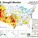
This U.S. Drought Monitor week saw an active pattern across the Northern Rockies, Northern Plains, and parts of the Midwest. In Montana, a slow-moving, low-pressure system delivered widespread heavy rainfall and flash flooding during the weekend. Across parts of the Southwest, eastern Great Basin, and Intermountain West, locally heavy monsoon rains continued to provide short-term relief to the region. In contrast, the Far West remained in a dry pattern except for some isolated thunderstorm activity in parts of the Mojave Desert in southeastern California. Overall, the seven-day average temperatures in the western U.S. were generally below normal. East of the Rockies, temperatures for the week were above normal – especially across the Southern Plains, Texas, and portions of the Midwest while New England and the Mid-Atlantic states experienced slightly cooler than normal temperatures. In the Midwest, locally heavy rains fell across portions of Iowa, Illinois, Indiana, Kentucky, and Ohio bringing relief to scattered dry pockets in the region. In the Southeast, hot and dry conditions led to further deterioration of conditions across parts of Alabama and Georgia…The Plains
Heavy rains fell across parts of the Northern Plains during the past week with two-to-six-inch accumulations in portions of North and South Dakota. Below-normal temperatures and rains led to the removal of Moderate Drought (D1) from South Dakota as well as areas of Abnormally Dry (D0) in the Dakotas and Nebraska. In southeastern Nebraska, short-term precipitation deficits and localized agricultural impacts on corn and soybean crops led to a minor expansion of an area of Moderate Drought (D1). In the Southern Plains, hot and dry conditions dominated the region with high temperatures exceeding 100° F in both Oklahoma and Kansas. Temperature departures from average were four-to-ten degrees above normal. In Oklahoma, drying ponds and low reservoir storage levels led to minor expansion of areas of Severe Drought (D2) in northeastern Oklahoma and Extreme Drought (D3) in southwestern Oklahoma…The West
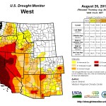
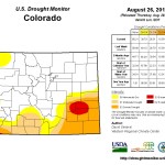
During the past week, significant rains fell across the eastern two-thirds of Montana. In central Montana, rainfall accumulations ranged from four-to-ten inches leading to flash flooding of local streams. According to the U.S. Geological Survey (USGS), the Missouri River at Landusky swelled to 35,000 cubic feet per second (cfs); well above mean flows at ~ 6000 cfs. In the Southwest, torrential monsoonal rains in the Phoenix Metro area and central Arizona led to flash flooding of dry washes and streams. In the Bradshaw Mountains north of Phoenix, four-to-eight inches of rain last week caused the Agua Fria River (above Lake Pleasant Reservoir) to swell to approximately 40,000 cfs (normal daily median discharge – 2 cfs), according to the USGS. The cumulative effect of the summer monsoon precipitation in Arizona led to one-category improvements in areas of Extreme Drought (D3), Severe Drought (D2), and Moderate Drought (D1) in central, southern, and western portions of the state. In these areas, beneficial rains improved the health of the vegetation, soil moisture, and surface water flows. Despite short-term gains in both Arizona and New Mexico, longer-term hydrological impacts (below-normal reservoir levels) remained after multiple years of below-normal snowpacks in the region’s mountain ranges. In New Mexico, the Middle Rio Grande Conservancy District recently curtailed water bank deliveries for irrigation in response to low flows along the Rio Grande. The combination of short- and long-term hydrological impacts (below-normal reservoir storage levels, below-normal mountain snowpack conditions in the headwater regions) led to the re-introduction of an area of Moderate Drought (D1) in the Middle Rio Grande corridor from Socorro County northward to Sante Fe County. In the Upper Colorado River Basin, recent monsoonal shower and thunderstorm activity has improved streamflows and reduced precipitation deficits leading to one-category improvements in areas of Extreme Drought (D3) Severe Drought (D2), and Moderate Drought (D1) in northeastern Utah and extreme northwestern Colorado. In California, recent showers and thunderstorms in the Mojave Desert (southeastern California) led to a one-category improvement in an area of Severe Drought (D2). Otherwise, conditions in California remained unchanged on the map. Elsewhere around the West, reservoir storage levels remained well below normal in Arizona, Nevada, New Mexico, and Oregon…Looking Ahead
The NWS WPC 7-Day Quantitative Precipitation Forecast (QPF) calls for moderate-to-heavy precipitation accumulations (two-to-six inches) in an area stretching from the High Plains eastward to the Upper Midwest with lesser accumulations across the Lower Midwest, New England, Mid-Atlantic, and the Southeast. One-to-three inches are forecasted across the Gulf Coast region while the western U.S. will remain largely dry. The 6–10 day outlooks call for a high probability of above-normal temperatures across California, the Southwest, and the eastern half of the U.S. while below normal temperatures are forecasted across the Pacific Northwest, northern Rockies, and Intermountain West. A high probability of above-normal precipitation is forecasted for the Eastern tier while the West will be below-normal.