


Click here to go to the US Drought Monitor website. Here’s an excerpt:
The Far West
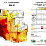
It was seasonably dry along the West Coast, with measurable precipitation limited to parts of the Sierra Nevada and northeastern California. To wit, areas of dryness and drought remained unchanged. The major reservoirs in California are in aggregate at 59% of the historical average, still above the 41% of average recorded during the 1976-77 drought. But some reservoirs are below 1977 levels, especially in west-central parts of the state, and water restrictions have been imposed statewide…The Rockies and Intermountain West
Generally moderate to heavy rains of 0.5 to locally over 3.0 inches fell from central Idaho and northwestern Wyoming southward through northeastern Nevada and adjacent Utah. Farther north, little or no rain fell, and across the southern half of the Rockies and Intermountain West, only scattered totals of over 0.5 inch and isolated reports topping one inch were noted.Monsoonal rainfall was relatively light in most locations, and with little or no rain affecting the southern deserts of Arizona, D3 conditions were expanded throughout that region. Farther north, increasing deficits led to deterioration in several areas of Utah, and dryness and drought expanded in central and western Montana, where streamflows and vegetative health were declining. Across Utah, most of Arizona, and adjacent sections of New Mexico and southwestern Colorado, only one-half to two-thirds of normal precipitation has fallen during the last 6 to 9 months.
The elevation of the Lake Mead water level has dropped to 1080 ft. (54% of the historical average), the lowest since the lake was being filled in the 1930’s. This is closest Lake Mead has come to dropping to its “ration level one” of 1075 ft. It has been below its “drought” level of 1l25 ft. for 28 of the past 33 months.
Lake Powell is low, but faring better. After reaching a level of 3574 ft. in mid-April (just over the 3rd percentile since 1964, and 64% of the historical average), the lake rebounded to 3608 ft. at the end of July (20th percentile)…
The Western Great Lakes and the Plains States
Moderate to very heavy rain, 4 to 8 inches in some areas, fell on many locations from the northeastern half of Oklahoma, Kansas, and southern Missouri northward through southern South Dakota, southwestern Minnesota, and the southwestern half of Iowa. Moderate rain was more scattered through the rest of this large region, with 0.5 inch or less falling on most of the upper Midwest, the central High Plains, southwestern Oklahoma, and central through northeastern Texas.As a result, areas of dryness and drought improved significantly across south-central South Dakota, central Nebraska, central Missouri, southeastern Kansas, central through eastern Oklahoma, and parts of central and northern Texas, plus a few smaller, isolated locations. The small area of exceptional drought was removed in eastern Colorado, and extreme dryness was eliminated in southern New Mexico, with additional improvements in other central and eastern parts of the state. However, in areas that missed the heavier precipitation, some areas of abnormal dryness were introduced, specifically in western Nebraska, western South Dakota, southwestern Wisconsin, north-central Iowa and adjacent Minnesota, and north-central Missouri. These areas generally received well under half of normal rainfall since mid-July, and 60-day shortages of 2 to almost 4 inches affect north-central Missouri, north-central Iowa and adjacent Minnesota, and southwestern Wisconsin…
Looking Ahead
August 14 – 18, 2014 is expected to bring a swath of moderate to locally heavy rain (0.5 to 2.5 inches) from the northernmost reaches of the Cascades, Intermountain West, and Rockies southeastward through most of the Dakotas, the upper Mississippi Valley, the southern Great Lakes Region, and the Ohio Valley. Light rainfall is expected for most other regions of dryness and drought, with scattered moderate rains dampening the Rockies. Little if any precipitation is expected in much of Georgia and South Carolina, central and southern Texas, the Great Basin, and the Far West south of the Cascades.The ensuing 5 days (August 19 – 23) favor above-median rainfall from the northern Rockies eastward through the northern Plains, the middle and upper Mississippi Valley, the Great Lakes, the Ohio Valley, the upper South, and the Northeast outside of New England. Below-median precipitation is anticipated for Oregon, Nevada, Utah, the Four Corners States, Texas, and adjacent parts of neighboring states. Elsewhere, neither unusually dry nor wet weather is favored.