
From The Pueblo Chieftain:
After two recent breaks in the Cotter Corp. Uranium Mill’s pumpback pipeline which returns contaminated water to an impoundment, officials on Friday outlined a plan to replace 3,500 feet of the pipeline.
Cotter officials reported two leaks occurring at the end of November and in early December in a pipeline that captures contaminated water that seeps past an earthen dam on Cotter Corp. Uranium Mill. It appears that both times the leaks were contained to Cotter property, according to Warren Smith of the Colorado Department of Public Health.
The now-defunct mill is undergoing the decommissioning process as health officials decide how best to safely retire the site. The pipeline proposal can be seen at http://recycle4colorado.ipower.com/Cotter/docspubreview.htm.
From the Public News Service – CO (Eric Galatas):
Conservation groups are gearing up to make sure their voices are heard as Colorado’s Water Plan heads into the implementation phase in the new year.
Nathan Fey, Colorado stewardship director for American Whitewater, said the last 100 years of water development have been focused on meeting demands at the tap along the Front Range and for agriculture, but added that he’s encouraged the state is embracing new priorities.
“We’re recognizing now, for the first time in Colorado, that recreation and river health is one of our primary values,” he said. “This plan has called out kind of a new ethic, and that is: we’ve got to protect our rivers. Because it supports this very robust recreation industry.”
Fey said river recreation in Colorado pumps $29 billion into the state’s economy, and the Colorado River basin accounts for $9 billion alone. He said people who care about rivers shouldn’t just leave the plan’s rollout to the state and utility companies, adding that American Whitewater will urge its members to join upcoming roundtables to make sure the plan’s stream and headwater protections go into effect.
Colorado’s Water Conservation Board projects that the state’s population, which surpassed 5 million people in 2008, will reach 10 million by 2050 – and most growth will occur in cities on the Front Range.
Fey said it’s important for residents to know that water used for golf courses, lawns and showers comes from the Western Slope. Conservation efforts, which feature prominently in the water plan, will be critical for its success, he said.
“We need to conserve water to support what we like today, to make sure that it sticks around into the future,” he said. “The more water we conserve now, the less it means we have to take water from somewhere else in the future – whether it’s out of the river or it’s from our food producers.”
If the collaboration, flexibility and innovation that helped produce the plan is carried forward into implementation, Fey said, he’s confident Colorado’s homes, agriculture and the birds and wildlife that depend upon healthy rivers for survival can all get the water they need. The water plan is online at http://coloradowaterplan.com.


From The Arizona Daily Star (Tony Davis):
For the second time in a decade, the feds are warning that if water interests in Arizona, California and Nevada can’t find a fix for the Colorado River’s problems, the interior secretary will find it for them.
Deputy Interior Secretary Michael Connor implied that was the department’s position in a talk Friday to hundreds of water officials, farmers and others gathered in Las Vegas for the 70th annual conference of the Colorado River Water Users Association. After his speech, Connor came right out and said it in response to a reporter’s questions.
Connor talked of the need to prevent Lake Mead, about 25 miles south of Las Vegas, from falling to dangerously low levels — potentially low enough to force Draconian cutbacks in water deliveries to cities and Indian tribes in Arizona, as well as to farms. The solutions haven’t been easy to find, in large part because they would require water users, particularly cities and farms in Arizona and California, to accept smaller cuts in water deliveries soon to stave off more severe cutbacks later.
The lake has dropped more than 120 feet since 2000. It’s expected to close 2015 at 1,082 feet elevation, 5 to 6 feet lower than a year ago. The first shortage in the river would be declared at 1,075 feet, but its effects would be far less drastic than shortages declared at lower lake levels that Conner raised concerns about.


This is a fascinating article about the Rocky Mountain Locust and the species’ demise from Jeffrey Lockwood writing for The High Country News. Click through and read the whole article. Here’s an excerpt:
How early settlers unwittingly drove their nemesis extinct, and what it means for us today
Picture swirling snow as far as the eye can see — in the middle of summer. Now, imagine this blizzard of flakes transforming into a swarm of locusts. This isn’t just any swarm, but the largest congregation of animal life that the human race has ever known. Picture yourself in Plattsmouth, Neb., in the summer of 1875.
A swarm of Rocky Mountain locusts streams overhead for five days, creating a living eclipse of the sun. It is a superorganism composed of 10 billion individuals, devouring as much vegetation as a massive herd of bison — a metabolic wildfire that races across the Great Plains. Before the year is up, a vast region of pioneer agriculture will be decimated and U.S. troops will be mobilized to distribute food, blankets and clothing to devastated farm families.
I came across an account of this staggering swarm in the Second Report of the U.S. Entomological Commission, published in 1880. By clocking the insects’ speed as they streamed overhead, and by telegraphing to surrounding towns, Dr. A.L. Child of the U.S. Signal Corps estimated that the swarm was 1,800 miles long and at least 110 miles wide. This suffocating mass of insects was almost large enough to cover the entire states of Wyoming and Colorado.
Swarms like this — albeit usually on a smaller scale — are part of the life cycle of locusts around the world. At low population densities, these insects behave like typical grasshoppers, to which they are closely related. But when crowded, this insectan Dr. Jekyll transforms into Mr. Hyde. Chemical cues from their feces and frequent disturbance of tiny hairs on their hind legs set off the changes. The changelings aggregate in unruly mobs, feed in preference to mating, grow longer wings and a darkened body, and irrupt into rapacious swarms…
The break in the case [ed. determining why they are extinct now] came during my teaching. In an effort to work some interesting (i.e., nonmathematical) elements into my Insect Population Biology course, I dug into the ecology of the monarch butterfly. Much like the locust, this species distributes itself across the face of the continent. And much like the locust, the monarch is poised on the edge of extinction in North America.
How could a butterfly that fills roadsides and fields from Texas to Maine be in jeopardy? After migrating northward each summer, this species returns to overwinter in the remote mountains of Mexico. Its populations stretch across North America, only to collapse back into a few shrinking pockets of forest. Loosed on these pockets, a logging crew armed with chain saws could put an end to this magnificent butterfly in a matter of weeks.
There was the answer, staring me in the face. Like the monarch butterfly, the Rocky Mountain locust was tremendously vulnerable at certain times in its life. Between outbreaks, the locust hid out in the river valleys of Wyoming and Montana — the same river valleys that settlers had discovered were best suited for farming.
By converting these valleys into farms — diverting streams for irrigation, allowing cattle and sheep to graze in riparian areas, and eliminating beavers and their troublesome dams — the pioneers unknowingly wiped out locust sanctuaries. They destroyed the locust’s equivalent of Mexican forest wintering grounds. They doomed the species.


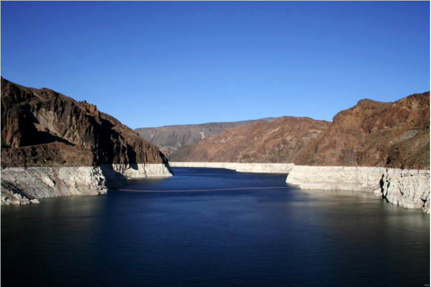
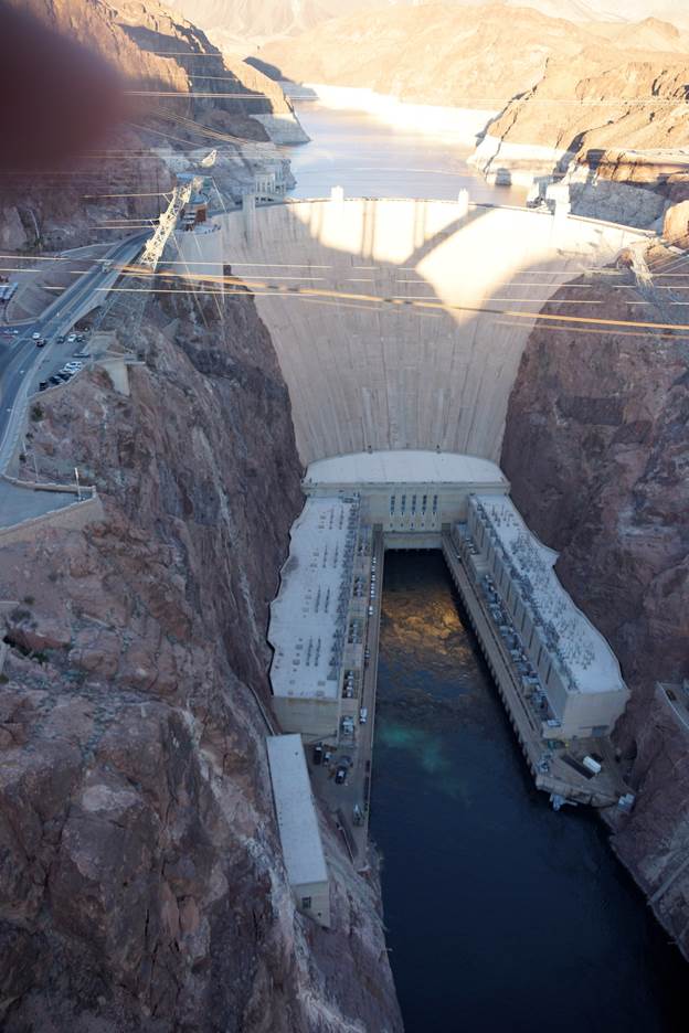
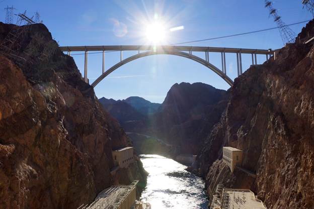
Check out this photo gallery from Hoover Dam and vicinity from the Las Vegas Review-Journal Thanks to @refriedBrean for the link.
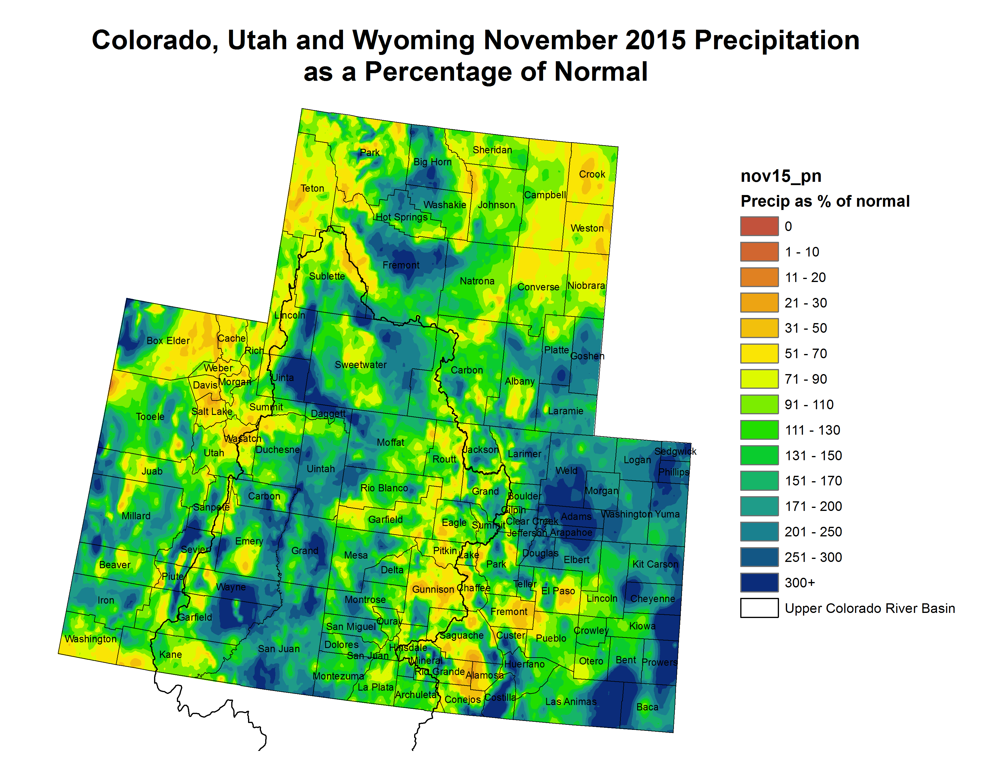
Click here to go to the Western Water Assessment Dashboard (Scroll down for the latest briefing). Here’s an excerpt:
Latest Monthly Briefing – December 17, 2015
Highlights
November saw wetter-than-average conditions over the majority of the region, especially in Colorado, though some key mountain areas were on the dry side. Snowpack conditions continue to lag behind normal in northern and central Utah, northwestern Colorado, and most of Wyoming. Snowpack conditions in the rest of Colorado, southern and eastern Utah, and southeastern Wyoming are near normal to well above normal. The current El Niño event has likely peaked but remains very strong. El Niño conditions are very likely to continue through the spring, with varying influences on weather across the region.
Here’s the release from Reclamation (Justyn Liff):
The Bureau of Reclamation has released a draft environmental assessment for the Lake Durango Water Pipeline Project.
The La Plata West Water Authority is proposing to construct a 4.6 mile water pipeline from Lake Nighthorse, part of the Animas-La Plata Project to Lake Durango in La Plata County, Colo. The purpose of the water pipeline is to meet the current and future needs for domestic water supply in western La Plata County.
The proposed project includes 4.6 miles of pipeline, an access road to the intake structure, a new 40×40-foot building around the existing intake chamber, a parking area, and a booster pump station. Currently, there is no way to pump water out of Lake Nighthorse. The pipeline and associated facilities will provide access and a way to deliver Animas-La Plata Project water.
The draft environmental assessment is available online at http://www.usbr.gov/uc/progact/animas/index.html, under the Environmental Compliance tab or a copy can be received by contacting Phillip Rieger at 970-385-6515.
Reclamation will consider all comments received prior to preparing a final environmental assessment. Written comments can be submitted by email to prieger@usbr.gov or mailed to Phillip Rieger, Bureau of Reclamation, 185 Suttle St. Ste. 2, Durango, CO 81301. Comments are due by Monday, January 10, 2016.

From KRCC (Matt Richmond):
Next year’s budget in Colorado Springs includes $16 million for stormwater repairs. Colorado Springs Utilities will also spend $3 million. Much of those funds are likely to go toward improving the Fountain Creek Watershed, which runs through Colorado Springs and down into Pueblo; and the list of projects that need to be done along Fountain Creek is long and expensive.
The Fountain Creek Watershed Flood Control and Greenway District funds projects in watersheds in El Paso and Pueblo Counties. Executive director Larry Small holds up a building under construction near Monument Creek, which is part of the Fountain Creek watershed, as an example of damages that seem to go unchecked.
“That development has created runoff, comes down the slopes, carries with it sediment,” says Small. “It’s more pronounced down here in this cut bank where the stream gets higher, undercuts the bank and the bank collapses into the creek.”
Up until 2010, Colorado Springs had a stormwater fund that was used to pay for damage like this. But the fund was eliminated and projects stopped. Small says that’s created an enormous backlog.
“[The Monument Creek watershed] is the largest watershed in the Fountain Creek watershed… Many streams are tributaries to Monument Creek and each of these have issues.”
For the entire Fountain Creek watershed, the needed work compiled by the district has a price tag of about $1 billion. Small says about half of that is in Colorado Springs.
In front of a Colorado Springs Utilities wastewater treatment plant downstream are projects completed by the utility. Small says they’re the same sorts of projects that were completed before the stormwater fund was eliminated.
“They would put in rip-rap like this to stabilize the banks,” says Small. “So those were capital improvements they would make. They would also maintain areas that had been eroded, where they had facilities and they’ve been damaged – for instance sediment collection ponds may have been filled in need to be cleaned.”
There is pressure on Colorado Springs to get back to work on these projects. The permit authorizing the Southern Delivery System, a pipeline carrying water north from Pueblo Reservoir, requires that Colorado Springs do more to control stormwater runoff before water deliveries begin. Pueblo County nearly voted to find the city in violation of that provision earlier this year, potentially closing down the whole pipeline. The Environmental Protection Agency and the state’s Department of Public Health and Environment will also review the city’s stormwater plans. The city faces a court injunction and fines.
Click here to go to the website. Click here to register.
From the La Junta Tribune-Democrat (Bette McFarren):
A very thoughtful and knowledgeable group of water stakeholders met Wednesday at Otero Junior College with representatives from the Colorado Water Conservation Board subcommittee on the Arkansas River Watershed Collaborative. The hope is that interests of southeastern Colorado and agriculture, somewhat synonymous, and those of the rest of the state can be worked out to the mutual advantage of all parties. Behind the meeting were Jay Winner of the Lower Arkansas Water Conservancy District, Caitlin Hansen of the Natural Resources Conservation Service and the CWCB and Arkansas Basin Roundtable. Assisting Deb Phenicie as moderator of the group was Mark Shea of Colorado Springs. Phenicie works under Carol Ekarius, executive director of the Coalition for the Upper South Platte and Coalitions & Collaboratives Inc…
The water quality issue and the flood control projects dovetail with the issue of junior water rights, which depend on water captured from flood events. Winner and other farmers and conservationists hope that some solution can be worked out that will benefit both southeastern Colorado/agricultural interests and water quality, without the disastrous buy and dry witnessed in Crowley County, now overcome by tumbleweeds and dust after its irrigation water was sold to interests in metropolitan Colorado.
The situation has been intensified by a 10-year drought, said one speaker. The past two years of adequate rainfall have not yet overcome the damage of the drought. Farmers and ranchers have sold off their livestock and are now reluctant to buy it back until they see the direction the market will take. Some have been good stewards of their land by replanting with cover crops and native grasses, but some have allowed weeds to take over. Weeds hold down the dust, said one speaker, but also lead to the scourge of tumbleweeds, which block roads and pastures and pile up against houses and barns. Tumbleweeds, along with salinity, were identified as major problems of the area.
District Forester Donna Davis of the Colorado State Forest Service saw diversified revegetation as a helpful improver of water quality by the slowing of sediment deposited in primary streams and also the filtering effect of roots.
Schweizer pointed out that the problem of fertilizer nutrients contaminating the watershed will be widely erased by the increased use of sprinklers rather than flood irrigation. Several of the stakeholders agreed that rotational fallowing, with or without the Super Ditch plan, was the best practical answer to prevent disastrous buy and dry projects.

From The Pueblo Chieftain (Chris Woodka):
When large tracts of land are disturbed, it takes more than good intentions to return it to something approaching a natural state.
The recipe includes water, seeds, know-how and — most importantly — time.
Those lessons have been learned in the most painful way over time in the Arkansas Valley as farmland has been taken out of production, sacrificed for pipelines, scorched by drought or ravaged by fire.
Fears that those lessons have not been learned well enough have surfaced this month as a patchwork plan for farm dryups was revealed by Arkansas River Farms. The company plans to dry up about 6,700 acres of the 14,400 acres it owns on the Fort Lyon Canal, using it to support wells on farm ground elsewhere.
The most painful lesson came for Ordway in 2008, when a fire ripped through dried-up farms in Crowley County that were no longer the responsibility of those who took the water off the land. The fire, started by a controlled burn fanned by winds, claimed two lives, 16 homes and 9,000 acres of mostly former farmland.
Water was first taken off farms in Crowley County in the 1980s, when water owned by a cattle feeding operation was sold to Colorado Springs, and most remaining Colorado Canal shares were snapped up by Aurora. By that time Colorado Springs and Pueblo had bought Twin Lakes shares that had provided supplemental water for Crowley County farms for decades.
Water courts insisted on revegetation plans when the Colorado Canal shares were converted in the late 1980s, as well as for the dry-up of farms on the Rocky Ford Ditch by Aurora. Those plans appeared to be complete, only to fall apart.
Shortly after the 2008 fire, the Lower Arkansas Valley Water Conservancy District sighted in on the dry-up as an important contributing factor.
Not long after, the district was successful in obtaining tougher court provisions for the Tri-State Generation and Transmission Association purchase of nearly half of the Amity Canal. Annual reports on all dry-ups, temporary or permanent were required in perpetuity. It has been successful in applying it in other water cases since then.
And this year, Aurora returned to lands dried up in its 1999 purchase of Rocky Ford Ditch shares even after revegetation was certified by a panel of experts. The drought had damaged some of the vegetation, so Aurora used some of its water to try to reestablish the grasses.
Aurora in 2000 had to come back to Rocky Ford land that was improperly revegetated from its first purchase.
All of which feeds into continued concern about the announced dry-ups on the Fort Lyon.
“Who’s going to have long-term responsibility to make sure this gets done?” said Jay Winner, general manager of the Lower Ark district. “We are looking at assuring revegetation in perpetuity, and it should be the responsibility of those who are moving the water.”
Winner pointed to contracts when water was sold to the Lower Arkansas Water Management Authority that required landowners who had sold their water to protect the land. That led to large dust storms blowing across the landscape – even across highways — during the recent drought. “When you see that — people have died from that — you realize that it should be the responsibility forever of those who are using the water,” Winner said.
One of the questions posed to Karl Nyquist, a partner in Arkansas River Farms, last week was whether water could return to lands that were dried up. The answer was uncertain.
Two conservation districts in Bent and Prowers counties are proposing a plan to monitor revegetation efforts in the Arkansas River Farms dry-up.
It’s modeled after Aurora’s most recent efforts, trying to incorporate all of the lessons which have been learned so far. They have pitched it to county commissioners before an application to change the use of water has been filed.
“What I told them was to not be in such a hurry,” said Bill Long, Bent County commissioner.
Fort Lyon Canal’s shareholders will have a hearing about the Arkansas River Farms plan on Jan. 28-29. But Long said the issues should be hashed out in water court, rather than predetermined.
On revegetation, Winner agrees.
“I believe the water court needs to be the policeman,” Winner said.

From The Denver Post (Bruce Finley):
Three million gallons a week of some of the West’s worst unchecked acid mine runoff — laced with lead, cadmium and fish-killing zinc — drain into headwaters of the Rio Grande River. A 270-gallons-a-minute flow from just one source, the collapsing Nelson Tunnel, led to a federal “environment disaster” Superfund designation in 2008.
But neither federal nor state environmental agencies did any cleanup work this year.
Or last year.
Or the year before. The federal cleanup, like most Superfund cleanups, is stuck in seemingly endless study.
And rather than rely on the government, which has documented tens of thousands of draining inactive mines, Creede is clinging to what residents hope will be a faster solution. They’re working for a comeback of mining, anathema at Colorado’s former mining towns that became elite resorts, but still much-loved here.
Creede has a unique opportunity because a nearby closed silver mine — the Bulldog — is connected to the Nelson Tunnel underground.
Mining engineers have determined that if Rio Grande Silver Inc., owned by mining giant Hecla, can restart silver mining at the Bulldog, the required pumping and treatment of pent-up wastewater would have the side effect of emptying the Nelson Tunnel and stopping the leak.
“If we want to get this cleaned up, and not have taxpayers pay for it, we should be encouraging mining, not prohibiting mining,” said Zeke Ward, chairman of the Willow Creek Reclamation Committee, a local watershed group.


Click here to read the latest edition of John Fleck’s Water News. Here’s an excerpt:
Deputy Interior Secretary Mike Connor Friday laid out the Colorado River doomsday scenario and urged basin leaders to push forward with ongoing negotiations to forge a water sharing deal to slow the decline in Lake Mead. Speaking on the final day of the Colorado River Water Users Association meeting in Las Vegas, Connor said that with climate change, the risk of a rapidly dropping reservoir is rising, with a 30 percent chance that Mead could drop past the critical elevation 1,020 in the next five years. At levels that low, water managers have no clear plans for how to ensure supplies for major water users downstream, on the farms and cities of Nevada, Arizona, and California. “Risk has increased,” Connor said.
Connor pointed to ongoing negotiations among Lower Basin water users to come up with an agreement that might slow Mead’s declines, an extension of the shortage sharing provisions worked out by the states and the federal government in 2007. But he also hinted at the difficulties ahead, which will require not only a deal at the basin scale, but one that is acceptable to the many water agencies in each state that have come to rely on an increasingly unreliable supply.
Here’s the release from Colorado State University (Anne Ju Manning):
There’s a lot of potential benefit to capturing graywater and stormwater to supplement traditional water supplies, but it doesn’t make sense for everyone, and there are plenty of legal, regulatory and climate-related hurdles in doing so, says Colorado State University’s Sybil Sharvelle.
Sharvelle, associate professor of civil and environmental engineering and head of CSU’s Urban Water Center, served on a 12-member national committee charged with addressing the benefits and challenges of stormwater and graywater as supplemental water sources, as the nation faces widespread water shortages and droughts. The National Academies report, released publicly Dec. 16, was two years in the making and provides information on the costs, benefits, risks and regulations associated with capturing these alternative water sources.
According to the report, stormwater is “water from rainfall or snow that can be measured downstream in a pipe, culvert or stream shortly after the precipitation event.” Graywater is “untreated wastewater that does not include water from the toilet or kitchen, and may include water from bathroom sinks, showers, bathtubs, clothes washers and laundry sinks.”
The report recommends best practices and treatment systems for the use of water from these sources; for example, in many locations with heavy rainfall, it’s possible to store excess water in aquifers for use during dry seasons. In some cases, stormwater captured at neighborhood and larger scales can substantially contribute to urban water supplies.
Graywater is best for non-potable uses like toilet flushing and subsurface irrigation. It has potential to help arid places like Los Angeles achieve substantial savings, and it serves as a year-round, reliable water source, according to the report. Larger irrigation systems and indoor reuse systems would require complex plumbing and treatment retrofits that are typically most appropriate for new, multi-residential buildings or neighborhoods for future urban planning.
The report cites the Eloy Detention Center in Arizona, which reuses graywater from showers and hand-washing to flush toilets. The facility has observed water savings of 20 gallons per day per inmate.
Sharvelle said the need for the report arose before the onset of widespread drought in the western United States.
“The use of these resources has been hindered by a lack of national guidance and ambiguous regulations for water quality targets,” Sharvelle said.
Sharvelle led an analysis of residential stormwater and graywater use in Los Angeles; Seattle; Newark; Madison, Wis.; Lincoln, Neb.; and Birmingham, Ala., and calculated potential savings for conservation irrigation and toilet flushing.
The bottom line is there’s no single best way to use these resources, because whether they’re successful or economically viable depend on a host of factors: legal and regulatory constraints, climate, and source water availability.
The report is online, and a webinar is planned for early 2016 to further detail the findings. The study was sponsored by the U.S Environmental Protection Agency, National Science Foundation and other agencies.
CSU’s Urban Water Center is part of the university’s One Water Solutions Institute, which seeks to connect CSU’s world-class research with real-world water challenges.


Friend of Coyote Gulch, Greg Hobbs, gave the opening talk at last week’s Colorado River Water Users Association annual meeting and then went trekking around with wife Bobbie and granddaughter Joni. Those of you that know Greg expect a history lesson from him. Here’s his photo poem for you:
Great American River, The Colorado
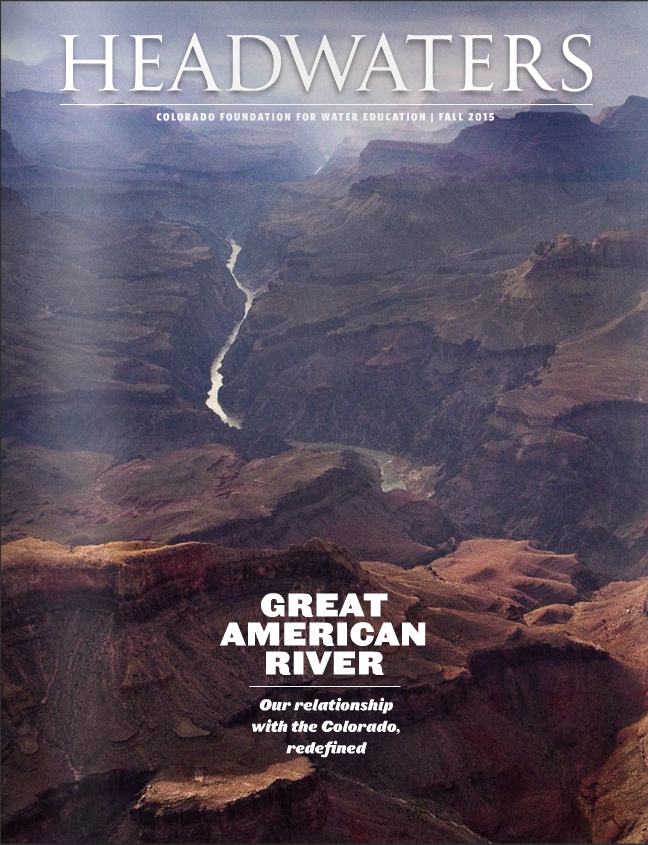
https://www.yourwatercolorado.org/cfwe-education/headwaters-magazine/fall-2015-colorado-basin
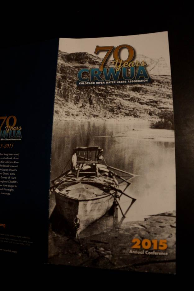
Celebrating the 70th Anniversary of the Colorado River Water Users Association
Delph Carpenter’s 1922 Colorado River Basin Map, Mead and Powell
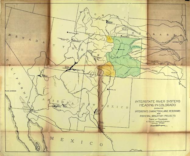
Powell the Upper Basin

Mead the Lower Basin
Before us the River is

Peoples tunnel to the Light

Through which the River flows
Through the land
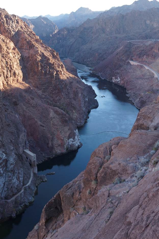
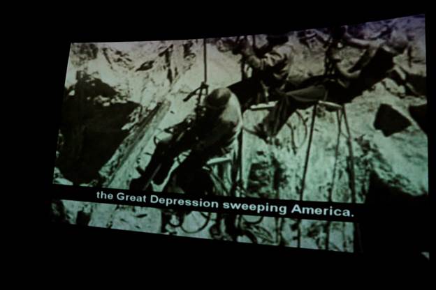
Out of the great Depression
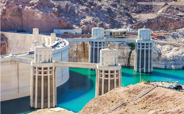
Arch of Water and Rock

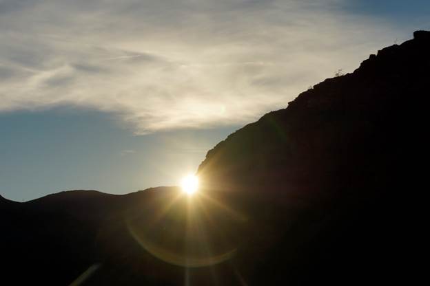
Under a Western Sun
Greg Hobbs 12/19/2015
Reprinted with permission ©2015 Greg Hobbs
From Inkstain (John Fleck):
I’m not sure who came up with the “More Slices than Pie” title for the panel discussion I moderated Thursday at the annual meeting of the Colorado River Water Users Association, but it had a nice ring. A big thanks to Tom McCann from the Central Arizona Project for putting the panel together and inviting me to help out. Important audience, important messages about the risks if basin water managers can’t come to grips with the need to stop draining their reservoirs so quickly.
There’s some important signaling here. For a long time, this thing we have come to call the “structural deficit” – the reality that paper allocations on the river exceed actual water supply – was an elephant in the room. It’s not that the overallocation problem was ignored in official discussions. People both inside and outside the basin’s water management institutions have talked about this for years…
There is a tension in the Colorado River management between the core group of managers operating at the basin scale who are trying to work out ways to deal with the overall shortfall, and water managers working at more local scales back home, who just want the water promised to them on paper by the deals negotiated back in the day. When it gets wet, as it did in the winter of 2010-11, it takes the pressure off of that conflict, because we can simply keep using water and sucking down the reservoirs rather than dealing with the shortfall.
But Mead is back to its record-setting lowest-it’s-been-since-it-filled ways. Thursday’s session putting the basin’s overallocation problem on the main stage at CRWUA for discussion by representatives of four of the major Colorado River Basin water agencies suggests that managing scarcity and risk rather than assuming abundance is, at least for now, the conventional narrative.
CRWUA is a strange and wonderful thing, an annual gathering that brings all the disparate elements of the disaggregated Colorado River water management community – federal, state, local, farm, city, environmental, recreation – together in one spot. In a system in which no one is in charge, this ritualized annual coming together is critical for the social capital needed to deal with the basin’s tough issues. I wish I had the formal skills of an anthropologist or one of those people who studies formal and informal networks. CRWUA would make a great field study area.
There’s an odd turn of phrase that I’m increasingly hearing in the Colorado River management community in describing the risk of Lake Mead dropping in a hurry – “blowing through 1,020”. It’s an action verb, describing a reservoir in free fall if we don’t get bailed out by whatever the opposite of climate change and drought are. The problem is that as reservoir levels decline, the V-shaped profile of the big Colorado River reservoir means that there’s less water for a given amount of elevation, which means that we shift quickly from dropping five or ten or fifteen feet per year to plummeting from 1,020 to 895 in a hurry. When I started working on Colorado River issues, “895”, the level at which you can’t get water out of Lake Mead, didn’t get talked about much. But the number came up a lot at this year’s CRWUA.

From The National Law Review (Fred E. Breedlove III):
Dwindling surface water supplies [in the Southwest and particularly in the Colorado River Basin] have revealed cracks in the roughly 150 year old bedrock foundation of Western Water Law – the prior appropriation doctrine…
[Prior Appropriation] is a system that has tended to concentrate the ownership of water in historic uses (such as agriculture) at the expense of more recent uses (such as industry and cities). Most states allow these rights to be moved to a different place or type of use (such as industry and cities) through a “sever and transfer” procedure, although this process can be complex and cumbersome.
One hundred fifty years ago, the primary concern being addressed by the law of prior-appropriation was ensuring that the first people to stake mining claims would have enough water to mine…Today, water from a single river system supports countless competing uses on a much grander scale that could not have been anticipated in the 19th century, including mining, agriculture, industrial, municipal/domestic, and environmental. Completely cutting off lower priority water uses on a river to ensure the full allocation of senior right holders’ deliveries are made at the expense of people downstream who depend on that water source for domestic potable uses can seem unfair at the least, dangerous at the worst. On the other hand, it is also unfair to force senior water right holders to give up water rights that they believed were fully protected under the law when deciding to invest in their use of that water. In both cases, there are also significant economic impacts associated with reduced or eliminated water deliveries that should be considered.
The solution to this problem, however, is probably not to completely scrap the aging prior appropriation doctrine. Rather, the doctrine can be salvaged by improving transferability of water rights. Peter Culp, Partner at Squire Patton Boggs (US) LLP, recently co-authored a comprehensive analysis of investment opportunities in the Colorado Basin and explored potential strategies for adapting the prior appropriation doctrine to the 21st century. Those strategies include water sharing agreements, water banking, leases, exchanges, and others.
For example, on the Colorado River, water users have come together voluntarily to address water scarcity in order to avoid the potential catastrophe that could result from a strict enforcement of the prior appropriation doctrine. Back in January of this year, I wrote about how Colorado River water users have agreed to preemptively share the burden of decreased supplies as a result of drought and climate change. The Lower Basin states are taking steps to develop (often through conservation) additional water in Lake Mead in order to stave off a shortage on the river that could have serious economic consequences…
Whether water users like it or not, change is not only coming, change is here. Even if drought ends tomorrow, a rigid system of water rights based on prior appropriation that lacks flexibility for allowing right transfers, water sharing agreements and other arrangements is untenable in the modern world where competing demands with high social and economic value conflict over limited water resources. The current shift to sharing risk and cooperative solutions to water scarcity problems is the way of the future.

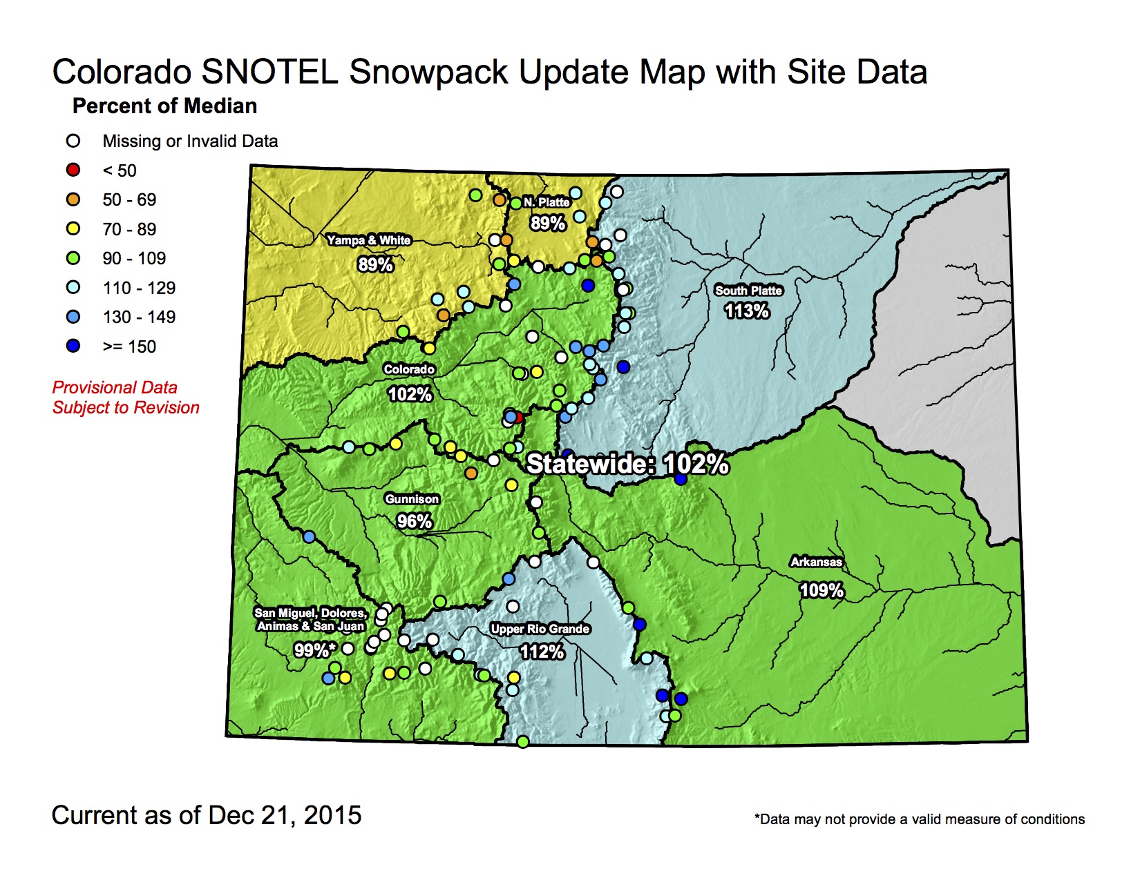
Click on a thumbnail graphic below to view a gallery of snowpack data from the Natural Resources Conservation Service


Here’s the release from The Wilderness Society (Max Greenburg):
Congress struck a deal on Dec. 18 to reauthorize the Land and Water Conservation Fund for three years—a hard-fought win after The Wilderness Society and our members spent months asking lawmakers to rescue the program.
Temporary reauthorization of the Land and Water Conservation Fund (LWCF) was passed as part of a federal appropriations bill that will fund our government for the coming year.
This small victory for LWCF probably could not have happened without the rallying cries of our supporters and those in the conservation community who sent countless messages to their members of Congress over the past six months. Thank you!
“The three-year extension and increased funding for the Land and Water Conservation Fund included in the bill, while falling far short of the permanent reauthorization the program deserves, is a good place to start that vital work,” said Jamie Williams, president of The Wilderness Society, in a statement. “Local communities will now see the impact of a revived LWCF that will need bipartisan champions to guarantee a long term solution for this critical program.”
The short-term renewal of LWCF is unequivocally a positive development that gives more time to America’s most important parks conservation program. While we are still seeking permanent reauthorization and full funding for LWCF, this step forward shows once again the importance of speaking out for the wildlands we care about, even in the face of daunting odds.
Months of hard work by our members got us here
For months, our members helped us tell Congress and President Obama how important the Land and Water Conservation Fund is to you and your communities. This helped build bipartisan support in Washington D.C., even though a few entrenched anti-conservationists stood in the way.
The 50-year authorization for the fund, which takes money from offshore oil and gas royalties and invests it in conservation projects across the nation, lapsed on Sept. 30. Under any other Congress, LWCF would have been renewed due to the fact that it enjoys broad support and has been very effective in protecting wildlands without relying on taxpayer money.
But, partly due to obstructionist tactics used by Rep. Rob Bishop (R-UT), chair of the House Natural Resources Committee, the task of renewing the project became a major feat. Ultimately, Bishop let the fund expire without giving it a hearing. This was part of a larger effort, backed by special interests, to lock up more federal lands and sell them off for mining, drilling and other development.
Over the fall, as our supporters tweeted and sent comments, more and more leaders from both sides of the aisle answered the call of the people by pledging their support for LWCF. President Obama even used his weekly radio address to call on Congress to renew the program. All of those steps led to today—and with your continued help, they will eventually lead to permanent funding and reauthorization.
LWCF protects wildlands without relying on taxpayers
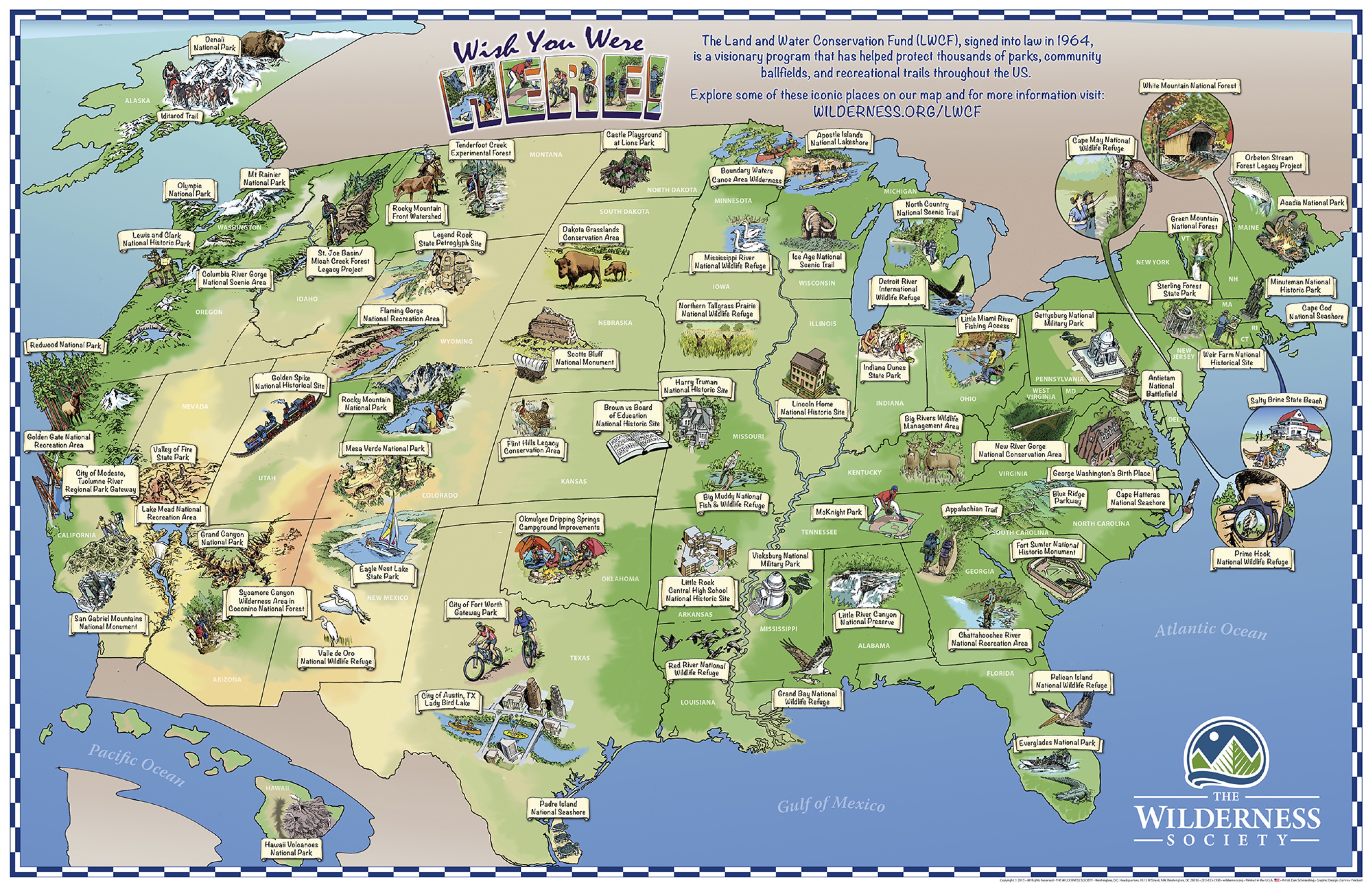
Created in 1964, the Land and Water Conservation fund takes royalties from offshore oil and gas leasing and gives those funds to the government to purchase land for parks and open spaces. The program has touched virtually every county in the nation—funding roughly 41,000 projects in all, ranging from the Grand Canyon to historic battlefields to local recreation centers.
While it has been a huge success, the Land and Water Conservation Fund’s potential has never been fully realized because Congress habitually raids the program’s trust fund to pay for unrelated projects, leaving vulnerable landscapes in limbo and diminishing opportunities for Americans to enjoy the great outdoors. This year, the program was dealt its cruelest blow yet, when Congress allowed it to expire. Today’s victory means we have a fighting chance at restoring it to its rightful place.
Full reauthorization still needed for time-tested fund
Though we just got some good news on LWCF, it is vital that we remain vigilant to ensure that the program is extended past the new 2016 expiration date and permanently funded. By voting to fully reauthorize the Land and Water Conservation Fund, Congress would ensure that future generations have access to healthy green spaces, parks, trails and places to watch wildlife. To get them to that point, we will need your voices to stay loud.
Stay tuned for more news on this effort and how you can help us get it over the finish line.
Click on the thumbnail below to explore highlights of “LWCF treasures”:
Here’s the abstract (Michael Dettinger, Bradley Udall, and Aris Geogakakos):
The western United States is a region long defined by water challenges. Climate change adds to those historical challenges, but does not, for the most part, introduce entirely new challenges; rather climate change is likely to stress water supplies and resources already in many cases stretched to, or beyond, natural limits. Projections are for continued and, likely, increased warming trends across the region, with a near certainty of continuing changes in seasonality of snowmelt and streamflows, and a strong potential for attendant increases in evaporative demands. Projections of future precipitation are less conclusive, although likely the northern-most West will see precipitation increases while the southernmost West sees declines. However, most of the region lies in a broad area where some climate models project precipitation increases while others project declines, so that only increases in precipitation uncertainties can be projected with any confidence. Changes in annual and seasonal hydrographs are likely to challenge water managers, users, and attempts to protect or restore environmental flows, even where annual volumes change little. Other impacts from climate change (e.g., floods and water-quality changes) are poorly understood and will likely be location dependent.
In this context, four iconic river basins offer glimpses into specific challenges that climate change may bring to the West. The Colorado River is a system in which overuse and growing demands are projected to be even more challenging than climate-change-induced flow reductions. The Rio Grande offers the best example of how climate-change-induced flow declines might sink a major system into permanent drought. The Klamath is currently projected to face the more benign precipitation future, but fisheries and irrigation management may face dire straits due to warming air temperatures, rising irrigation demands, and warming waters in a basin already hobbled by tensions between endangered fisheries and agricultural demands. Finally, California’s Bay-Delta system is a remarkably localized and severe weakness at the heart of the region’s trillion-dollar economy. It is threatened by the full range of potential climate-change impacts expected across the West, along with major vulnerabilities to increased flooding and rising sea levels.
Raw Video of Tornado in Kiowa County, Colorado near Eads 5/9/15:
Simla, CO Tornadoes – June 4, 2015:
June 5, 2015: Kit Carson Co., CO Cyclic Tornadic Supercell:
From BizWest (Dallas Heltzell):
“Participants in NISP began work on studies required by the National Environmental Policy Act in 2004,” said Eric Wilkinson, general manager of the district known as Northern Water. “These studies are required to look at all facets of the project to clearly define the project’s impact on the environment as well as ways to avoid, minimize or mitigate those impacts. These studies are complex, requiring significant resources and specialized expertise. That is evidenced by the nearly 12 years and approximately $15 million that the participants have invested to date.
“Most studies have been completed but some require additional time, thus the reason for the extension,” said Wilkinson on Wednesday in a prepared statement. “The project participants have supported, and continue to support, a thorough NEPA process to assure the Final Environmental Impact Statement is comprehensive, complete, and defendable. Participants are working diligently to assure this extension has minimal effect on the beginning of project construction.”
The Corps said it still has more than a dozen tasks to complete, including study of the voluminous number of public comments it received when a draft version of the EIS was released in June. That document prompted a chorus of official complaints. The federal Environmental Protection Agency wrote a 20-page letter in September contending that the Corps’ draft EIS lacked sufficient information to adequately predict the project’s potential impacts or compliance with provisions of the Clean Water Act. The Fort Collins City Council, acting on its staff’s recommendation, voted unanimously to oppose NISP in its current form. City officials in Greeley, which is not a NISP participant, said the reduced flows would force that city to spend $10 million on extra water filtration, and its Water and Sewer Department wrote that the Corps’ water-quality analysis was insufficient and not in compliance with NEPA.
Larimer County commissioners, however, passed a resolution in support of NISP…
About a dozen cities and towns and four water districts have signed up to buy water from the project if it wins final approval from the Corps.
Supporters see the project as crucial to keeping up with the growing demands of development, industry and agriculture along the Front Range, as well as capturing rainfall and snowmelt in wet years that otherwise would flow out of the state.
Opponents have said it would drain water from the Poudre as it flows through Fort Collins, limiting opportunities for recreation that include tubing, whitewater kayaking and fishing,
Northern Water’s boundaries include about 880,000 people living on 1.6 million acres in portions of Boulder, Broomfield, Larimer, Weld, Logan, Morgan, Sedgwick and Washington counties.

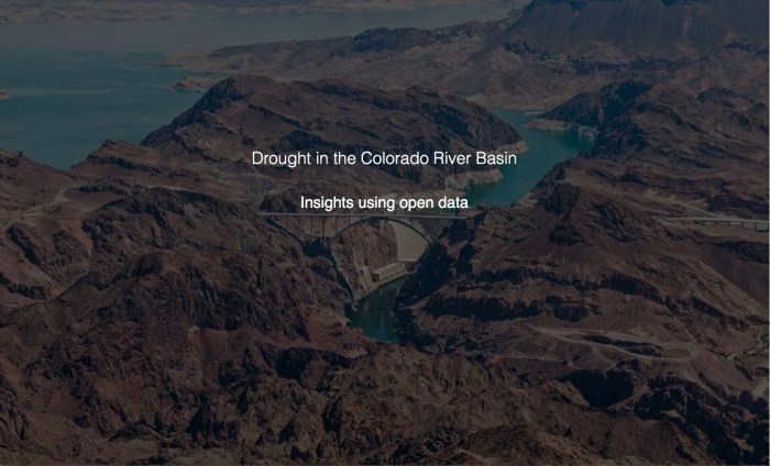
Say hello to this cool new website from the US Department of Interior. It uses and Open Data to tell the story of the long-term drought in the Colorado River Basin.
From The Grand Junction Daily Sentinel (Charles Ashby):
After nearly six years on the job, Mike King is leaving the Colorado Department of Natural Resources.
The Montrose native who has headed the department since Gov. John Hickenlooper came into office in 2010 announced Thursday that he was trading in that job for one some Western Slope folks might find, well, somewhat interesting.
He’s to be the new director of planning at Denver Water.
In his new job, King is to oversee Denver Water’s long-range planning for treated and raw water supplies, demand and supply management, water rights, environmental compliance, watershed management and climate change preparations.
“As the son of a West Slope water lawyer and a Wayne Aspinall Democrat, this is a new time and Denver Water is a different organization than back in the day,” King said. “They’ve been moving in the right direction, and I look forward to helping them get there. They’re about as progressive as any agency I can imagine, so it’s all good.”
King added, however, that people should watch what he does and hold him accountable for it.
Hickenlooper, who said he’s still looking for a replacement, praised King for all the work he’s done during his administration, including helping to devise a statewide water plan and working on compromises on oil and gas drilling practices.
During his time on the job, King also helped Hickenlooper merge the department’s parks and wildlife divisions, and helped devise Colorado’s roadless rule with the U.S. Forest Service.
“Mike brokered the oil and gas task force, helped create the state’s first-ever water plan and recently launched Colorado Beautiful, the most ambitious trails and recreation expansion in a decade,” Hickenlooper said. “His ability to balance industry and conservation concerns is unparalleled.”
Several groups have praised King for the job he’s done leading the department.
“During that time, he oversaw important natural resource projects,” said Pete Maysmith, executive director of Conservation Colorado. “We have appreciated Mike’s sophisticated understanding of these very complex issues and support on environmental priorities, such as protection of the Roan Plateau, negotiation of a strong sage grouse plan and advocacy on behalf of the in-stream flow program.”
King, who has worked at the department for about a decade under several executive directors before becoming one himself, said he was pleased with what he’s accomplished, but that it was time to move on.
“I put my heart and soul into it and moved the ball,” he said. “We’ve done incredible things with the water plan, the Rio Grande cooperative agreement, and watched Denver Water reach agreement with the Colorado River cooperative, so we’ve made some incredible progress on water.”


Click here to go to the US Drought Monitor website. Here’s an excerpt:
California, the Pacific Northwest, and the Northern Rockies
Another stormy week was experienced across most of the region, leaving only the southeastern California desert and part of the San Joaquin Valley devoid of significant precipitation. The heaviest precipitation – more than one foot – affected part of the Washington Cascades, interior northwestern Washington, northwestern Oregon, southwestern Oregon, and northwestern California. Amounts exceeded 3 inches in other areas from the Cascades to the Pacific Coast, most of Humboldt and Mendocino Counties in California, the higher elevations in west-central Idaho, and parts of northeastern Idaho and adjacent Montana. The lightest amounts – between 0.5 and 1.5 inches – fell on the interiors of Washington and Oregon, southwestern Montana, and southern Idaho.
Temperatures averaged a few degrees above normal, so the precipitation did not build up snowpack as much as would be expected this time of year. Snowpack water content is generally above normal in central and eastern Oregon, northern Washington, and western Idaho, but remains considerably below normal along the Cascades, in northern Idaho, and across adjacent northwestern Montana.
Dryness and drought improved once again across large parts of the region as a result. Most of Washington, the western half of Oregon, and northwestern California all improved by 1 classification, as did parts of Idaho and a small section of northwestern Montana where precipitation has been heavier than in nearby areas…
The Great Basin, the Four Corners States, Wyoming, and Montana east of the Rockies
Generally light to moderate precipitation fell on the region, leaving dryness and drought almost entirely unchanged. The only adjustment was made in north-central Colorado, where 1 to locally 4 inches of precipitation brought an end to abnormal dryness for the time being…
The Mississippi Valley, Great Plains and High Plains
A broad swath of moderate to heavy precipitation was observed in part of the Plains from Iowa and eastern Nebraska southward through most of Kansas, the southeastern Plains, and the western side of the Mississippi Valley. Between 2 and 4 inches fell on these areas, with amounts closer to 6 inches measured in southeastern Oklahoma and northeastern Texas. Prior to this week, dryness only affected a few portions of this broad area…but where it did, conditions were significantly relieved. Abnormal dryness was removed from northeastern Iowa, southeastern Minnesota, and adjacent Wisconsin while the broad abnormally dry area across central and eastern Kansas was reduced to two relatively small areas in the central and east-central parts of the state (where moderate drought existed last week). Precipitation totals for the first half of December exceeded 4 inches in a broad area from southeastern Nebraska and Iowa southward through the southeastern Plains and Mississippi Valley, with amounts of 8 to locally 20 inches drenching eastern Oklahoma and surrounding areas.
In other parts of the region, light to moderate precipitation had little effect on the existing dryness and drought in the Dakotas and adjacent Minnesota, the northern and central High Plains, and a few spots in central and southern Texas, including the southern Big Bend region; however, moderate drought was improved to D0 in part of central North Dakota, and a few small areas of abnormal dryness popped up along the Rio Grande River in southern Texas…
Looking Ahead
During December 17 – 21, storminess should continue across the Pacific Northwest, northern California, most of Idaho, and adjacent parts of surrounding states. Precipitation totals in most of the area should be moderate, ranging from about an inch to a few inches, but areas from the Cascades to the West Coast will likely get soaked again. More than a foot could fall on parts of coastal Oregon. Farther east, light to moderate precipitation, with isolated amounts of up to 1.5 inches, are expected across the areas of dryness and drought in the East. From the Appalachians to the Rockies and in the Southwest, existing dry areas shouldn’t expect much relief, with only a few tenths of an inch at best anticipated. Temperatures are forecast to average several degrees above normal from the Plains to the East Coast, and near normal in most other locations.
The odds favor wet weather across almost the entire contiguous 48 states during the ensuing 5 days (December 22 – 26), with the highest likelihoods covering areas from the Mississippi Valley to the Appalachians in the East, and the central and northern Rockies, northern and central Intermountain West, and Oregon in the West. Very mild weather is possible across the eastern half of the country, but unusually cold weather is anticipated in Alaska.
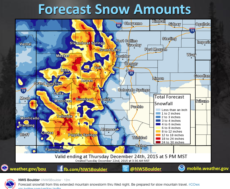
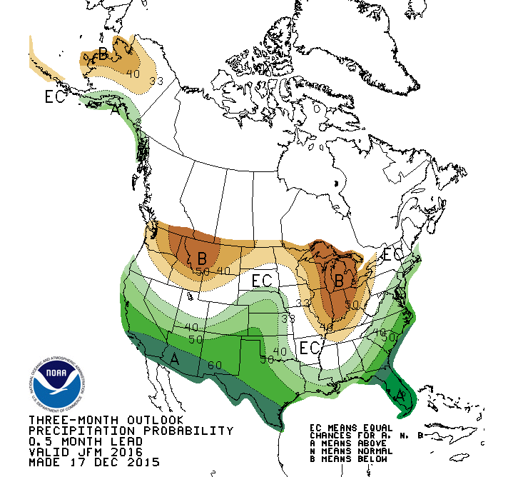
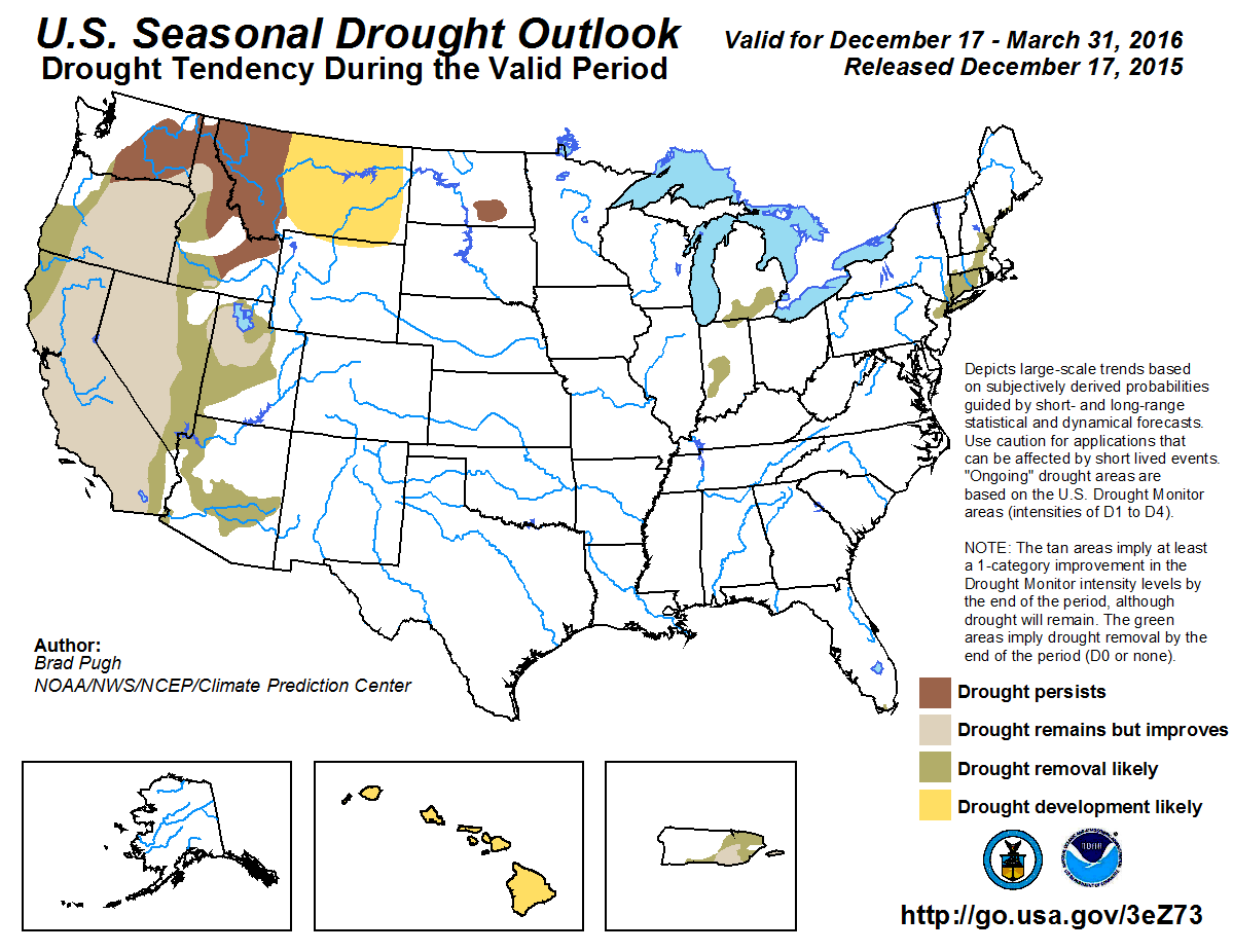
Here’s the Seasonal Drought Outlook released today from the Climate Prediction Center:
Here’s the release from Denver Water (Stacy Chesney):
Mike King, executive director of the Colorado Department of Natural Resources, has been selected as the new director of Planning for Denver Water.
King will oversee Denver Water’s long-range planning for treated and raw water supply systems, demand and supply management, water rights, environmental compliance, watershed management, and climate change preparations. He will be a member of the executive team, reporting to the chief executive officer and the Denver Board of Water Commissioners.
“We are very excited that Mike has accepted the position of director of Planning for Denver Water,” said Jim Lochhead, CEO. “Colorado remains a highly desirable place to live. Growth and the uncertainties of climate change will continue to challenge not only Denver Water but also the entire state. Mike’s knowledge of water, his statewide leadership on environmental issues and his proven strategic skills are a perfect combination for this position.”
As director of Planning, King will be responsible for helping guide Denver Water’s integrated resource planning (IRP) process. The IRP uses scenario analysis to inform Denver Water’s long-range capital replacement and expansion programs, including water collection, storage, treatment, distribution and recycling. The IRP further incorporates Denver Water’s commitment to conservation and water-use efficiency.
His responsibilities also will include ensuring Denver Water continues to operate in an environmentally sustainable manner. He will be responsible for policy and regulatory issues, including developing watershed management plans and addressing endangered species issues.
“I am very excited to join Denver Water at this time in the organization’s history,” said King. “Denver Water is a leader in resource management and is recognized as one of the most progressive water utilities in the nation. Denver Water’s mission to be a responsible steward of our natural resources aligns with my experience and skills, and perhaps most importantly with my core values. I will bring to Denver Water the same energy and commitment to public service that I have for the past 23 years to the State of Colorado.”

Click here to view a gallery of photos from Wild Earth Guardians. From the website:
The sagebrush steppe basins of the Intermountain West and the shrub-steppe grasslands of the High Plains are home to an abundant diversity of wildlife.
In pockets of relatively pristine habitat, like Wyoming’s Red Desert, the diversity and abundance of sagebrush wildlife draws comparisons to the Serengeti in Africa.
But sagebrush habitats are shrinking in the West, threatened by livestock grazing, invasion of nonnative, extremely flammable cheatgrass, and subsequent unnaturally frequent wildfires.
On the Plains and in the Rocky Mountain basins, sagebrush habitats are defenseless against agricultural conversion and fossil fuel development. Very little of the Sagebrush Sea has been designated for any formal protections; safeguarding our most diverse and productive sagebrush ecosystems represents one of our generation’s most urgent conservation challenges.

From the Denver Business Journal (Ben Miller):
Whiting Oil & Gas Corp., a unit of Denver-based Whiting Petroleum Corp., has sold its Redtail saltwater disposal and fresh water transportation and storage system in Weld County for $75 million.
Whiting sold the system to BNN Water Solutions, a unit of Tallgrass Energy Partners of Leawood, Kansas.
The water system consists of 148,000-acre system consists of 62 miles of pipeline along with associated fresh water ponds and disposal wells.
Click here to view the gallery of photos from the Department of Interior via The Daily Mail UK. Colorado made the list.

From USA Today (Bill Theobald) via the Fort Collins Coloradan:
The annual spending bill negotiated by congressional leaders is stuffed with millions in additional funding for Western needs — from fighting wildfires to fixing national parks and helping deal with the drought.
In addition, a companion bill would extend tax breaks for solar and wind power.
Both bills are expected to be approved by the House and Senate in the next few days.
The budget legislation would fund the government for the rest of the fiscal year that ends Sept. 30. It would reauthorize the popular Land and Water Conservation Fund for three years and appropriate $450 million for the fund to be spent through the Department of Interior and the Forest Service.
The fund has provided $17 billion through its 50-year lifetime to fund more than 40,000 local recreation projects and to buy about 5 million acres of public lands, mostly in the West…
Funding in the budget bill is $50 million more than President Obama requested, a 47 percent increase from last year. More than 50 percent of the money will go for local and state recreation projects.
Alan Rowsome of The Wilderness Society had said Congress would be snatching “defeat from the jaws of victory” if it failed to permanently reauthorize the fund and increase the amount that could be spent.
For wildfires, the legislation includes $4.2 billion for wildfire fighting and prevention programs within the Department of the Interior and the Forest Service. That’s $670 million more than last year and includes $1 billion in firefighting reserve funds.
This provision is sure to disappoint members of the House and Senate — mostly from the West — who have been pushing legislation to revise funding for fighting wildfires. Fighting the most severe fires, under these proposals, would be paid for like other natural disasters such as tornadoes and come from emergency funds.
That would eliminate the need during several recent severe fire seasons to transfer money into firefighting from other activities, including efforts to reduce the number and severity of fires. The bill includes $545 million for hazardous fuels reduction, an increase of $19 million from last year.
Other provisions of interest to the West in the budget legislation include:
National Park Service. The service gets $2.9 billion, up $237 million, including $94 million to reduce the massive maintenance backlog at the parks and to mark the service’s centennial anniversary in 2016. Drought relief. While no comprehensive drought package is included, $100 million is appropriated for the Bureau of Reclamation to address severe drought in the West. Tax breaks include five-year extensions of the production tax credit for wind energy and the investment tax credit for solar energy. Sen. Barbara Boxer of California said the ITC would create about 61,000 jobs in 2017 and retain another 80,000 solar jobs. The American Wind Energy Association estimated extending the PTC would add more than 100,000 jobs in four years in the wind industry.
“I believe the extension of tax credits for solar and wind energy is a game changer,” Boxer said.


From the University of Utah via (e) Science News:
Mountain pine beetle populations have exploded over the past decade due to warmer temperatures and drier summers, and these insects have infected and killed thousands of acres of western pine forests. Researchers have predicted that as trees died, streamflow would increase because fewer trees would take up water through their roots. A recent study by University of Utah geology and geophysics professor Paul Brooks and his colleagues in Arizona, Colorado and Idaho, found that if too many trees die, compensatory processes kick in and may actually reduce water availability. When large areas of trees die, the forest floor becomes sunnier, warmer and windier, which causes winter snow and summer rain to evaporate rather than slowly recharging groundwater.
The bad news is that the loss of so many trees may not help alleviate the long-term drought in the West as many have hoped. The good news is that researchers can use the new understanding of forest water cycle to manage healthier forests that are more resistant to drought but still supply water to agriculture and cities downstream.
This is the first empirical evaluation of streamflow response to widespread tree mortality from mountain pine beetles in more than 30 years and is the largest study of its kind, says Brooks.
Brooks presented this research at the American Geophysical Union’s annual meeting this week in San Francisco. The AGU annual meeting is the largest Earth and space science meeting in the world.


Here’s the release from Colorado State University (Christina Vessa):
Anne Castle, former Interior Department assistant secretary, will be present the keynote speech at the 2016 Water Tables fundraiser for the CSU Water Resources Archive. The event will take place from 5 to 9:30 p.m. on Thursday, Jan. 28, at the Hyatt Regency Denver Tech Center.
Castle was Assistant Secretary for Water and Science from 2009 to 2014. During that time, she oversaw water and science policy for Interior, and had responsibility for the U.S. Bureau of Reclamation and the U.S. Geological Survey.
She will be on hand to help celebrate the Water Resources Archive’s achievement of 100 collections. The theme of Water Tables 2016 is “The Historic One Hundred.”
This year, each table host will discuss one of the Archive’s collections. Some of the different collections include Friends of the Poudre Records, the Northern Colorado Flood Oral History Collection, the Tom Pitts Papers, and many more.
Registration is $160 per ticket, $75 of which is considered a charitable donation to the Water Resources Archive. Ticket cost includes reception, table discussions, keynote, dinner and dessert.
To make reservations, follow this link to the Colorado Water Congress website.
The CSU Water Resources Archive encompasses collections documenting the history and development of water resources in Colorado and the West. Subjects included in the Archive are engineering studies, law and legislation, water resources management, and endangered species, among others.
Questions? Find out more information about the Water Tables 2016 event.
From WestSlopeNow.com (Mallory Pearson):
After weeks of debate, congress has decided to pass a three year re-authorization on the program dedicated to impacting state parks and outdoor recreation.
According to Colorado Parks and Wildlife, the state saw a total of 750,000 dollars in 2014.
“If you look at the state of Colorado, there have been many parks and many projects that have gone towards enhancing outdoor recreation in perpetuity,” says Mike Porras with Colorado Parks and Wildlife. “So, overall the state has benefited, it’s benefited all the citizens of the state.”
According to the Center For Western Priorities, the bill authorizing a permanent renewal for the Land and Water Conservation Fund now has 200 bipartisan cosponsors.

From The Denver Post (Bruce Finley):
“We want the end result, which is a cleaner Animas River,” San Juan County Commissioner Scott Fetchenhier said after a four-hour session.
On Wednesday, locals asked EPA officials whether they’d have an equal voice in Superfund decision-making. EPA officials told them they would be involved but, under federal law, the EPA would make decisions.
The officials assured locals funding would be available for a Superfund cleanup. The EPA already has spent about $15 million on emergency actions including set-up of a temporary water treatment system along Cement Creek to filter Gold King drainage laced with cadmium, arsenic, lead, zinc and other heavy metals.
Gov. John Hickenlooper would have to sign off and request a Superfund cleanup. It would start with a required remediation investigation then a feasibility study before cleanup — typically lasting a decade or longer.
The EPA and CDPHE canceled a Wednesday public meeting in Silverton because of snow Monday that diverted a flight, but they held two days of closed talks with town and county officials, including one trustee and commissioner.
Locals fear a Superfund designation without adequate funds.
“That wouldn’t get the Animas cleaned up,” said Fetchenhier, a geologist. “The whole goal is to get the Animas River better.”
Silverton and county officials say they’re reluctant to trust the EPA but see no better option with a promise of significant funds needed for a complicated fix.
Some of the toxic metals in Cement Creek, which flows into the Animas, occur naturally. But more than 480 gallons a minute of untreated drainage from the Red and Bonita, Mogul, Sunnyside and other inactive mines flows down through Silverton to the river.
The local proposals for efficient, practical cleanup range from putting a permanent water treatment plant at a place where it could catch more bad water, which likely would cost $20 million plus $1.5 million a year for operations in perpetuity, to the proposal by Durango Geophysical Operations to drain Sunnyside.
Sunnyside Gold, owned by the Kinross Corp. mining conglomerate, rejects the idea, adding that there is no risk of a similar blowout at Sunnyside.
“The state-approved, engineered and reinforced concrete bulkheads installed by Sunnyside Gold at the American Tunnel were designed by industry experts, reviewed, pressure-tested and approved by all relevant agencies, and are not comparable to the dirt and debris that temporarily blocked off the Gold King,” Sunnyside reclamation manager Larry Perino said. “Sunnyside Gold is not aware of any conceivable reason that the Sunnyside Mine should be drained.”
Sunnyside on Wednesday confirmed it is offering $10 million to improve water quality, in return for the EPA and state agencies “acknowledging Sunnyside has no further liabilities in the district.”
Draining Sunnyside would cost millions and entail removal of the bulkhead plugs, said Rhoades, the former commissioner who helped install those plugs in the mine after it closed in 1991.
Any pent-up water flowing between Sunnyside and the Gold King and Red and Bonita mines would have had to move through natural faults, because no tunnels connect the mines, Rhoades said.
CDPHE spokesman Warren Smith said talking about cleanup options is premature pending a decision on whether Silverton will request a Superfund designation and, after that, completion of a remediation investigation and feasibility study.
Silverton remains divided about Superfund and its drawn-out processes. Any designation would have to be narrow, covering only Gladstone and upper Cement Creek, commissioners said.


From the Boulder Daily Camera (Carol O’Meara):
On the surface, the Colorado Water Plan approved Nov. 19 by Gov. Hickenlooper is an ambitious road map for managing, conserving and protecting this vital resource.
But still waters run deep, and if you look closely, you’ll see the plan is designed to help Colorado face climate change, population boom, protect wildlife, keep agriculture vibrant and support economic growth.
All while preserving our quality of life.
“Our water picture has changed over the last 10 to 15 years; it’s no longer good enough to just have water law managing our water,” said James Eklund, director of the Colorado Water Conservation Board, which wrote the plan.
“We’ve had record fires, flooding and historic drought — the worst we’ve ever measured. We’re warmer by 2 degrees; our summers are going to be hotter and our growing season extended.”
[…]
“With water being recognized as a major factor for the state’s long-term growth, now comes the tough discussions and decisions needed to implement a state water plan that works and delivers the quality of life we all treasure,” said Kristen Fefes, a board member for GreenCO, which is an alliance of seven landscape-related associations.
Landscape water use accounts for 3 percent of state water, which might seem like a drop in the bucket. But a study commissioned by GreenCO suggests that homeowners reducing over-irrigation by 10-20 percent can save 86,500 acre-feet of water over 40 years.
“Because landscape water use is so visible, it is often the main target — and main solution — for saving water. But it’s not the only solution,” Fefes said. “There’s no silver bullet; it’s going to take work on a lot of fronts to conserve water. We believe that xeriscape and other sustainable landscape practices will continue to gain popularity with Colorado consumers. They’re already a business model for us.”
Education might be the biggest challenge and an area where Fefes hopes the state and local policy makers lean on the green industry.
“Landscape water use is complicated and how much to use depends on a variety of factors — soil, sun, slope,” Fefes said. “There’s no one answer to ‘how much water does landscape use?’ Industry members have technical knowledge to give customized answers to homeowners. We can be a big asset for state and local policy makers in education, outreach, and implementation.”
Eklund and Fefes agree that urban landscapes are integral to our quality of life and not expendable. Its value to mitigating heat islands and reducing pollutant runoff is just as important to sustainability as water conservation.
“The knee-jerk reaction is that we can conserve our way out of this, but we’re looking at all the tentacles into lives that could trip us up,” Eklund said. “The heat island effect could mean that a person keeps their air conditioning on. If a person stops watering their lawn and it dies, when it does rain we get all that dirt and pollutants washing off and into the wastewater system where we all pay money to treat it.”
Eklund adds: “We must create a conservation culture, use efficient irrigation, teach our kids that we live in a high desert and water is limited. People moving here need to know that, too, and not plan for the lush landscapes they might have had back east.”
The green industry is committed to being partners with the CWCB in closing the water gap, Fefes said. Find tips for how you can conserve by signing up for the ALCC Tip of the Week at http://lcc.com. Find the Colorado Water Plan at http://coloradowaterplan.com.
From email from Ground Floor Media (Gil Rudawsky):
Coinciding with the Colorado River Water Users annual conference this week, attached you will find a list of the 2015 highlights for the Colorado River Basin, along with a teaser about what will likely make headlines in 2016. In addition, we included a list of subject matter experts, most of whom are at CRWUA and available for interviews.
The experts are from American Rivers, National Audubon Society, Environmental Defense Fund, The Nature Conservancy, Trout Unlimited and Western Resource Advocates.
Click here to read about the highlights and look ahead.
Click here to go to the Colorado River Water Users Association website.

From The Durango Herald (Jessica Pace):
Agreeing that collaboration is key, New Mexico environmental officials extended a hand in partnership to La Plata County during a Wednesday meeting about long-term water monitoring plans.
Four months after an Environmental Protection Agency-caused spill at the Gold King Mine in Silverton sent 3 million gallons of acidic wastewater into the Animas and San Juan rivers work continues for entities throughout the Four Corners. They want to establish long-term plans to monitor not only the impacts of the Aug. 5 spill, but the long-standing issue of abandoned mine drainage and other pollutants affecting regional water quality.
On Wednesday, officials with the New Mexico Environment Department shared the state’s plan with La Plata County in an effort to open lines of communication. New Mexico has worked closely with the Navajo Nation and Utah stakeholders in the aftermath of the spill, but communication with Colorado has been minimal.
“Monitoring plans will be separate, but should complement one another,” said Cabinet Secretary Ryan Flynn.
New Mexico met with San Juan County officials in October, when the draft plan was released. It includes identifying the quality of water impounded in Upper Animas Watershed mines as well as mill tailings and waste rock that could discharge into surface water.

Click here to read the newsletter. Here’s an excerpt:
RESEARCHERS CALL FOR WATER USE CUTS
The Colorado River Research Group recently released the report “A Look at the Interim Guidelines at Their Midpoint: How Are We Doing?” The guidelines include an agreement on how to cut Colorado River water use in the lower basin when Lake Mead hits critical elevations. The report notes that the guidelines have bought time for avoiding crisis but calls for permanent reductions in water use.


My friend, Allen Best, writes in email earlier this week:
Inside this issue you will find what you’ve come to expect from Mountain Town News: A breezy overview of what’s happening and what’s being reported in mountain resort regions of the West, supplemented by a few, deeper stories.
One of those deeper stories in this issue originally appeared recently in Ski Area Management. The richly researched story examines the vulnerability of ski areas to rising temperatures. As I prepare to distribute this issue, a photo arriving by e-mail shows a fairyland in Aspen. The weather is delightful, especially for skiing. The climate? It’s more uneven but tilting against the economics of snow-based tourism and real estate.
And so it goes, as the late Kurt Vonnegut used to write. In every issue of MTN, you’ll find reporting that is both brief and deep in resort regions of the West. Your subscriptions keep me going. For individual subscribers, it’s about $2.50 per issue, the same as the Wall Street Journal purchased at a newsstand. Most institutional subscribers pay more, but the cost per individual reader is much less, perhaps less than what you throw in the tip jar for Starbucks baristas on your way out the door.
Here’s my problem. To avoid becoming a barista myself, I need more subscribers, more advertisers, or both, to make this work. MTN subscribers have been remarkably loyal, but I lose some every year, and too few new subscribers arrive to replace them.
“But why don’t you just put it on a website and then sell advertising?” Good idea — except who makes money on websites? It’s an expense, not income. I suppose I could start writing about the top 10 celebrities who are skiers or solicit advertising about how to make your skis thicker and longer. That’s not what I do. The logic of a free-access website is the same logic as a ski area that gives away lift tickets, intending to make its money by advertising. Know any of those?
You need MTN because it delivers an easy read that keeps you abreast of what is happening in Colorado and other mountain resort regions. It’s very affordable.
What YOU can do is persuade a friend, acquaintance or business associate that a MTN subscription has great value and delivers great value. And be sure to remind them that quality journalism like this does not come without great time and effort.
Also tell them if they liked this issue, they’ve probably missed a great many issues of value. And again, it’s a bargain — a cup of coffee per issue. Less, if you prefer the foo-foo drinks. Perhaps a former mayor or town manager, a county manager or local environmental non-profit?
I do ask for your assistance.
Allen Best
303.463.8630
allen.best@comcast.net
Allen is a great writer. I’ve linked to many of his water stories here on Coyote Gulch over the years. Please subscribe to The Mountain Town News.
Click on a thumbnail graphic to view a gallery of snowpack data from the Natural Resources Conservation Service.


