Click here to go to the US Drought Monitor website. Here’s an excerpt:
California, the Pacific Northwest, and the Northern Rockies
Another stormy week was experienced across most of the region, leaving only the southeastern California desert and part of the San Joaquin Valley devoid of significant precipitation. The heaviest precipitation – more than one foot – affected part of the Washington Cascades, interior northwestern Washington, northwestern Oregon, southwestern Oregon, and northwestern California. Amounts exceeded 3 inches in other areas from the Cascades to the Pacific Coast, most of Humboldt and Mendocino Counties in California, the higher elevations in west-central Idaho, and parts of northeastern Idaho and adjacent Montana. The lightest amounts – between 0.5 and 1.5 inches – fell on the interiors of Washington and Oregon, southwestern Montana, and southern Idaho.
Temperatures averaged a few degrees above normal, so the precipitation did not build up snowpack as much as would be expected this time of year. Snowpack water content is generally above normal in central and eastern Oregon, northern Washington, and western Idaho, but remains considerably below normal along the Cascades, in northern Idaho, and across adjacent northwestern Montana.
Dryness and drought improved once again across large parts of the region as a result. Most of Washington, the western half of Oregon, and northwestern California all improved by 1 classification, as did parts of Idaho and a small section of northwestern Montana where precipitation has been heavier than in nearby areas…
The Great Basin, the Four Corners States, Wyoming, and Montana east of the Rockies
Generally light to moderate precipitation fell on the region, leaving dryness and drought almost entirely unchanged. The only adjustment was made in north-central Colorado, where 1 to locally 4 inches of precipitation brought an end to abnormal dryness for the time being…
The Mississippi Valley, Great Plains and High Plains
A broad swath of moderate to heavy precipitation was observed in part of the Plains from Iowa and eastern Nebraska southward through most of Kansas, the southeastern Plains, and the western side of the Mississippi Valley. Between 2 and 4 inches fell on these areas, with amounts closer to 6 inches measured in southeastern Oklahoma and northeastern Texas. Prior to this week, dryness only affected a few portions of this broad area…but where it did, conditions were significantly relieved. Abnormal dryness was removed from northeastern Iowa, southeastern Minnesota, and adjacent Wisconsin while the broad abnormally dry area across central and eastern Kansas was reduced to two relatively small areas in the central and east-central parts of the state (where moderate drought existed last week). Precipitation totals for the first half of December exceeded 4 inches in a broad area from southeastern Nebraska and Iowa southward through the southeastern Plains and Mississippi Valley, with amounts of 8 to locally 20 inches drenching eastern Oklahoma and surrounding areas.
In other parts of the region, light to moderate precipitation had little effect on the existing dryness and drought in the Dakotas and adjacent Minnesota, the northern and central High Plains, and a few spots in central and southern Texas, including the southern Big Bend region; however, moderate drought was improved to D0 in part of central North Dakota, and a few small areas of abnormal dryness popped up along the Rio Grande River in southern Texas…
Looking Ahead
During December 17 – 21, storminess should continue across the Pacific Northwest, northern California, most of Idaho, and adjacent parts of surrounding states. Precipitation totals in most of the area should be moderate, ranging from about an inch to a few inches, but areas from the Cascades to the West Coast will likely get soaked again. More than a foot could fall on parts of coastal Oregon. Farther east, light to moderate precipitation, with isolated amounts of up to 1.5 inches, are expected across the areas of dryness and drought in the East. From the Appalachians to the Rockies and in the Southwest, existing dry areas shouldn’t expect much relief, with only a few tenths of an inch at best anticipated. Temperatures are forecast to average several degrees above normal from the Plains to the East Coast, and near normal in most other locations.
The odds favor wet weather across almost the entire contiguous 48 states during the ensuing 5 days (December 22 – 26), with the highest likelihoods covering areas from the Mississippi Valley to the Appalachians in the East, and the central and northern Rockies, northern and central Intermountain West, and Oregon in the West. Very mild weather is possible across the eastern half of the country, but unusually cold weather is anticipated in Alaska.
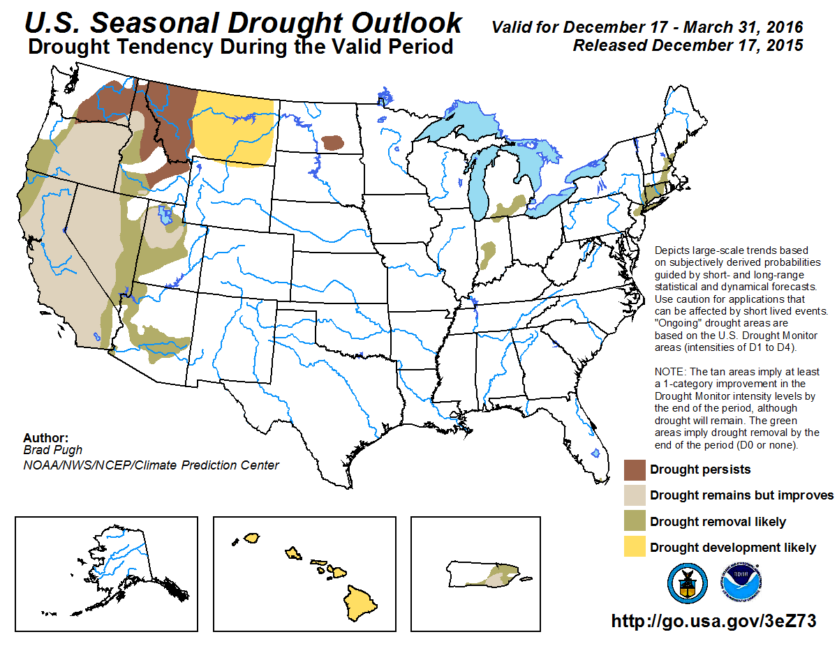
Here’s the Seasonal Drought Outlook released today from the Climate Prediction Center: