
From The Greeley Tribune (Nikki Work):
A snowy week across the state added to Colorado’s already positive snowpack numbers, according to the Natural Resources Conservation Service.
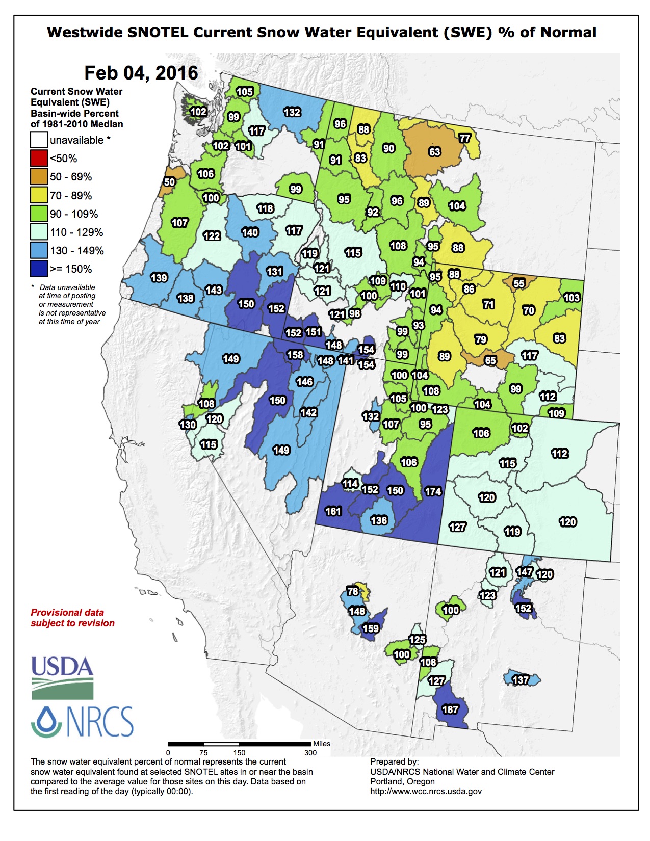
The whole state is above the historic average for snowpack, and the river basins that impact Weld County — the South Platte and the Upper Colorado — are both more than 10 percent above normal. These levels impact what the summer water supply will look like for the area, according to Brian Werner of the Northern Colorado Water Conservancy District.
As of Thursday, the South Platte River Basin was 12 percent above the historic average, and the Upper Colorado River Basin was 15 percent above average.
Reservoir storage numbers are up as well, with nearly every basin in the state above average as of Feb. 1. Werner said it’s important to use both snowpack and reservoir numbers to examine future water supply, because once the weather warms up in the spring and summer, and the snowpack melts, the pressure will fall on the reservoirs.
The South Platte River Basin is up 5 percent, and the Upper Colorado River Basin is up 9 percent. As a whole, the state is up 10 percent.
For the southern part of the state, which has suffered from drought for several years, these numbers are cause for hope. Werner said at a recent water meeting, he saw water officials from the southeast and southwest counties smiling for the first time in a while.
However, Werner said it’s too early to get comfortable, because while the averages are up in comparison to previous years, the most important months for snowpack are March and April, because that’s when the wettest snows of the year come. Werner said he’s seen winters where the snowpack numbers have been up early in the winter, but a dry spring has derailed hopes of a good water year.
In order to see one of those, we’ll need to see more snow, he said.
Though it’s too early to get cozy, Werner said he anticipates a good water year for farmers and ranchers, who have been sitting mostly pretty since the massive drought in 2012. If the snowpack and reservoir numbers stay on track, farmers shouldn’t have to worry about water supply restricting their acreage, he said.
From The Aspen Times (Scott Condon):
The storm that dumped 37 inches of snow on the slopes of Aspen’s ski areas Saturday into Tuesday was the 10th largest storm cycle in 37 years, according to Aspen Skiing Co.’s records. Skico Vice President of Operations Rich Burkley said the last big storm cycle was February 2014.
The storm did wonders for Aspen’s snowpack. It was at 100 percent of normal going into the weekend at an automated measuring station near the headwaters of the Roaring Fork River, according to the U.S. Natural Resources Conservation Service. It now stands at 115 percent of average.
In a recent posting on the Colorado Avalanche Information Center, Aspen zone forecaster Blase Reardon noted that 20 percent of the snowpack that has accumulated so far this season fell during the most recent storm. The avalanche danger spiked with one-fifth of the snowpack accumulating in just 72 hours.
Closer to Aspen, the storm on the last day of January boosted total snowfall for the month well above average, according to weather observer Laura Taylor at the Aspen Water Treatment Plant. She reported that 11 inches of snow fell Jan. 31. For the month, the water plant received nearly 35 inches of snow. The average is 26 inches. Only 5.26 inches of snow fell in January 2015, according to the water department’s records.
The Natural Resources Conservation Service reported that every major river basin in the Colorado mountains is running well ahead of last year’s snowpack levels. The Colorado River basin, which includes the Roaring Fork drainage, is 116 percent of last year’s snowpack as of Feb. 1. River basins in southwestern Colorado are 185 percent of last year’s snowpack.