Click here to go the US Drought Monitor website. Here’s a excerpt:
Summary
A large upper-level ridge of high pressure dominated the Lower 48 States (CONUS) this USDM week, keeping much of the country warmer and drier than normal. Low pressure troughs moving in the jet stream flow brought precipitation to the Pacific Northwest, northwest California, and the Northern Rockies; parts of Texas and the Gulf of Mexico coast; and the coastal Southeast to Mid-Atlantic States and eastern Great Lakes. But, except for Texas and a few areas in the coastal Carolinas, even with the precipitation the week was drier than normal. The continued and prolonged dryness in many areas resulted in expanding and intensifying drought, especially in the Central to Southern Plains, Lower Mississippi Valley to Ohio Valley, and Southeast to Northeast…
The Great Plains
One to 2 inches of rain fell in parts of Texas, and North Dakota had a tenth of an inch or less, but most of the Great Plains had no precipitation this week. There was some contraction of D0 in Texas where the rains fell, but more expansion of D0-D2 occurred with the addition of a new oval of D3 over northeast Texas and adjacent southeast Oklahoma. D0-D2 also expanded in parts of Oklahoma, D0 expanded in Iowa and Missouri and adjacent parts of Illinois, and D0-D1 expanded in western Kansas and Nebraska and adjacent parts of Colorado. The Oklahoma State Climatologist’s office has received widespread reports of low or dry farm ponds, dry soils and ruined crops. In LeFlore County, cattle producers are already feeding hay due to the lack of forage caused by drought conditions, and water supplies in the northern half of the county are becoming very depleted. Reports of drought impacts in the Arklatex, received by National Weather Service personnel, include much lower than usual stock ponds and significant risk for wildfires…
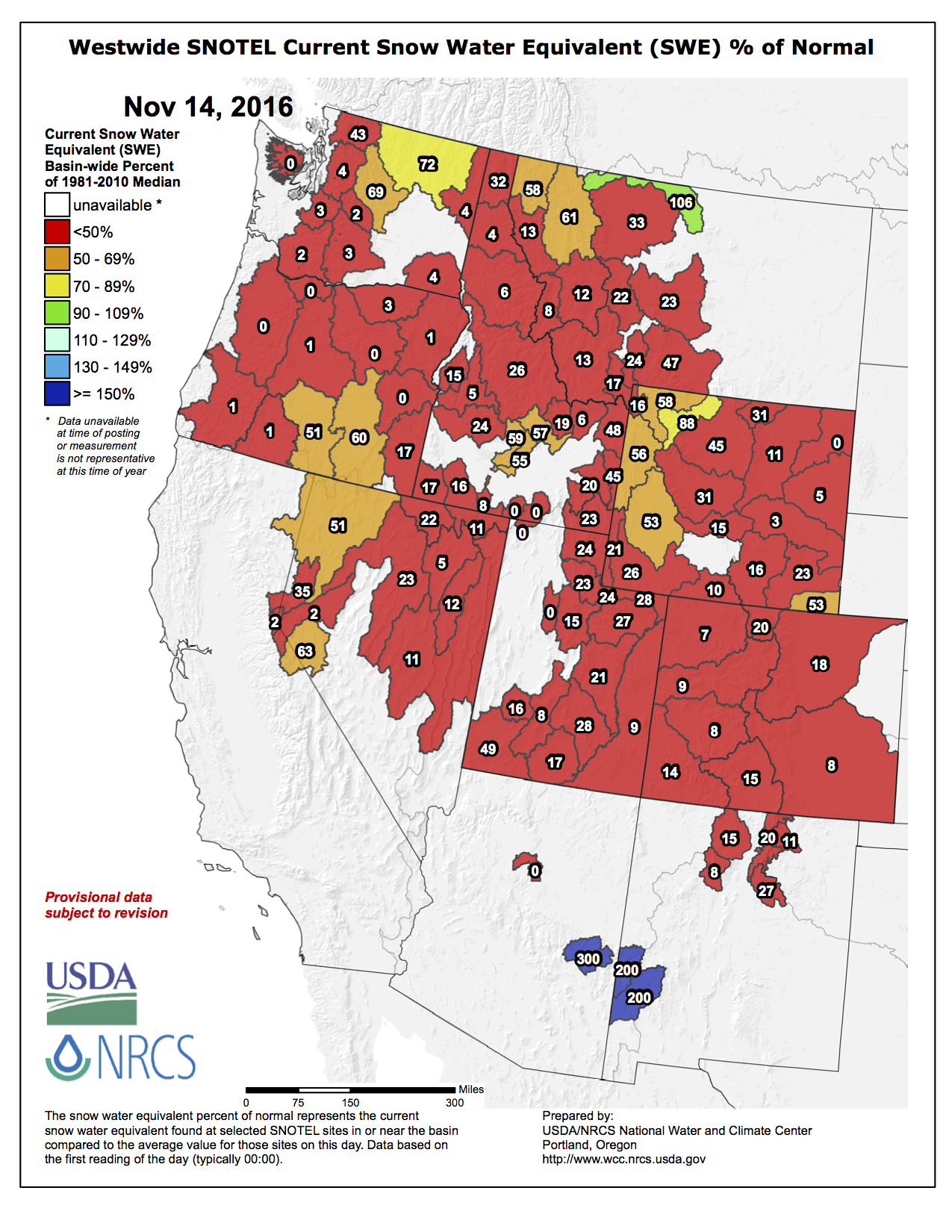
The Rockies and Far West
Precipitation fell from northwestern California, across the Pacific Northwest, and much of Montana this week. But this is well into the wet season for the Northwest, so the precipitation that fell was still below normal in most locations. No precipitation fell outside these areas. Temperatures were well above normal across the West. Additional changes in Colorado include the insertion of a couple D2 spots, and D0-D1 was expanded in south central Wyoming. Otherwise, no changes were made to the drought depiction in the West. The Colorado Climate Center noted that the warm, dry weather of the last month or two has led to an abysmal start to the snowpack season with all major river basins in Colorado reporting less than 25% of average snowfall by this point in the cold season. The lack of snowpack is evident across most of the West…
Looking Ahead
In the 24 hours after the valid time of the November 15 USDM, a low pressure system dropped 1-2 inches of rain across parts of the Northeast and another system brought additional precipitation to the Pacific Northwest. During November 22-26, above-normal precipitation is expected across the Far West, the Midwest, and Northeast, while below-normal precipitation is forecasted for Texas, the Southeast, Montana, North Dakota, and Alaska. A similar pattern is evident in the outlook for November 24-30. Odds favor drier than normal weather in the Southern Plains to Southeast, Montana, and eastern Alaska, and wetter than normal weather across the Far West to Central Plains, Northeast, and western Alaska Temperatures are expected to be below normal along the East Coast but above normal for the rest of the CONUS and parts of Alaska for the entire period, November 22-30.