This four-part series contrasts the processes behind the Colorado Water Plan with four other recent western water plans: California, Texas, Montana and Oregon.
The production cycle of the Colorado Water Plan is a three-phase process, which involves regional engagement and project planning through basin roundtables and Basin Implementation Plans; statewide modeling, published in the Technical Update, and the publication of a comprehensive statewide plan. Not all states directly involve regional groups in state water plan development. Within the five Western water plans researched for this series, two states mandated the production of a high-level statewide policy document; while three states, including Colorado, mandated a regional or “basin” planning effort to inform statewide processes.
These approaches can be described as “top-down” and “bottom-up.” A top-down approach produces a water plan entirely directed and developed through state agencies, with designated periods for public comment. The final product of a top-down approach, exemplified by the California and Oregon state water plans, is described by state agencies as a high-level policy plan. In contrast, a bottom-up approach is rooted in the recruitment of regional planning groups. These groups develop unique basin plans that directly inform the content and directives of the state water plan. Examples of this planning approach include Colorado, Montana and Texas. The product of a regional approach constitutes multiple products: multiple basin plans and a single comprehensive state water plan. This idea is embodied in the figure below, which features Colorado’s nine Basin Roundtable boundaries.
This figure distinguishes two types of water plan production: a “top-down” process, executed and directed by state agencies; and a “bottom-up” process, where the production of regional plans informs the content and policy directives of a comprehensive statewide document.
A legacy of collaboration
The choice to pursue one strategy or another is rooted in the history of each states’ water governance, as well as contemporary policy and budgetary requirements. The Colorado Water Plan’s mandate for regional planning directly builds on the legacy of the basin roundtable process. The basin roundtable process was established in 2005 by the passage of House Bill 05-1177, “Colorado Water for the 21st Century Act.” This bill codified a deeply collaborative approach to addressing regional water concerns and visions for the future. This legislation also established the Interbasin Compact Committee to operate as a statewide forum for basin roundtables. The success of these volunteer groups directly informed the engagement efforts mandated in the 2013 gubernatorial executive order that called for the production of Colorado’s first statewide water plan.
Trends across Western water plans: expanding regional engagement, water education, and data accessibility
Regardless of the degree of regional authorship within a state water planning process, there is interest across Western state water plans in investing in locally identified water projects. For example, documents associated with California’s most recent “2018 Update” underscore a state interest in funding regional priorities. The report “Funding Mechanism Inventory and Evaluation” identifies watershed or river basin assessments as a potential vehicle for the state of California to fund locally-identified management actions.
This trend in regional engagement is concurrent with an effort to expand water education programming and water policy accessibility. To this end, state water plans including Texas, California, and Colorado have developed (or are currently developing, in the case of Colorado!) interactive online components that will accompany their water plans. While the 2019 Utah Water Plan was not explicitly examined for this blog series, it will notably prioritize a new webpage interface over traditional printing.
Recently published Western state water plans reflect an increasing emphasis on data transparency and accessibility, as well as state planning processes that better integrate stakeholder and regional perspectives into state water policy.
Hannah O’Neill. Credit: Water Education Colorado
Our next post, to be published the week of December 9, will contrast how uncertainty is incorporated across Western water plans. Read the first post in our Western Water Plans series, “How does the Colorado Water Plan compare to our neighbors,” here.
Hannah O’Neill is a graduate student at CU-Boulder studying environmental policy and western water management. Hannah is a fifth generation Coloradan and Denver native, who has a professional background in fossil exploration and National Environmental Policy Act compliance. Hannah obtained a BS in Geology-biology from Brown University in 2014.
Earlier this yr, the seven states that depend upon the Colorado River made historical past. For the primary time, Arizona, California, Utah, Nevada, Wyoming, Colorado, and New Mexico agreed to search out methods to cut back the quantity of water they draw from the river as ranges drop additional at Lake Mead, the most important reservoir within the nation.
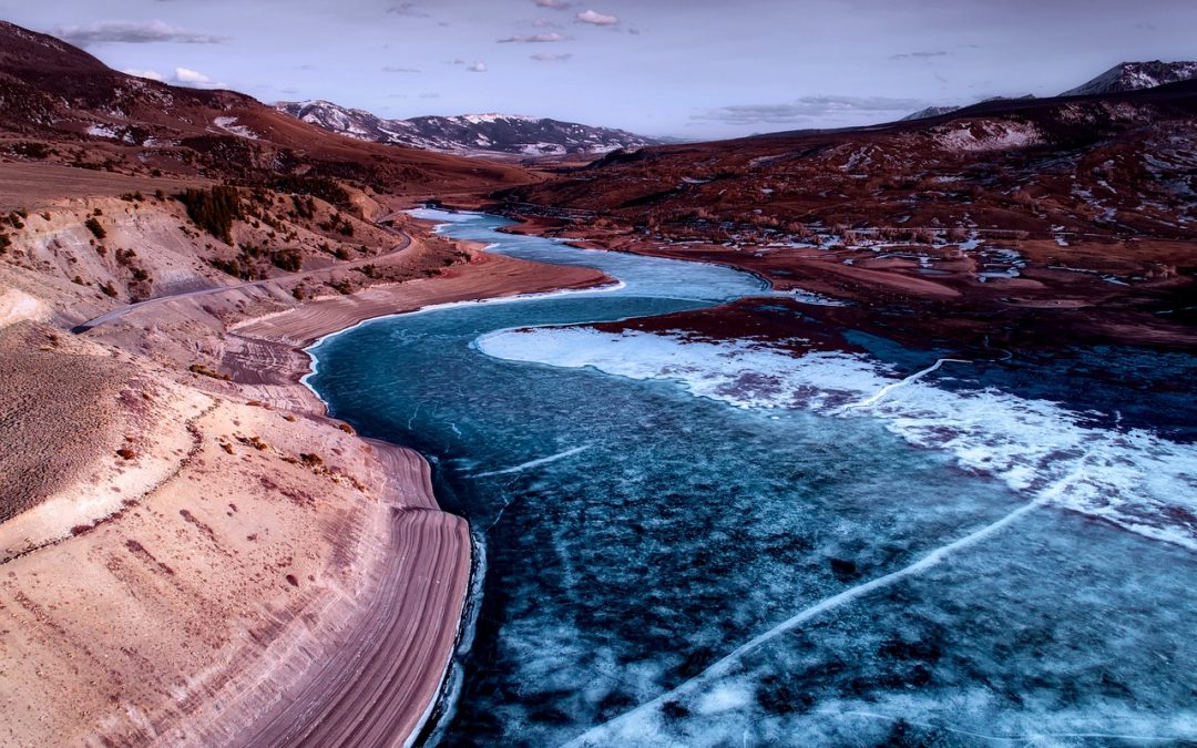
The Colorado River gives water for 40 million folks. However its flows are shrinking because the planet heats up, decreasing the snowpack that feeds the river and inflicting extra water to evaporate because the river snakes its approach from the Rocky Mountains to the Gulf of California.
However even when local weather change weren’t a difficulty, the Colorado would in all probability nonetheless be in hassle. Again in 1922, when states initially divvied up water from the river, they grossly overestimated the quantity of water flowing via it. This set in movement a collection of selections that led to the shortages immediately. States are dipping into Lake Mead’s reserves, overdrawing 1.2 million acre toes of water yearly — sufficient to quench the thirst of a pair million households for a yr.
As standard knowledge has it, the states have been counting on unhealthy knowledge after they divided up the water. However a brand new guide challenges that narrative. Flip-of-the-century hydrologists truly had a fairly good concept of how a lot water the river may spare, water consultants John Fleck and Eric Kuhn write in Science be Dammed: How Ignoring Inconvenient Science Drained the Colorado River. They make the case that politicians and water managers within the early 1900s ignored proof concerning the limits of the river’s assets.
In 1916, six years earlier than the Colorado River Compact was signed, Eugene Clyde LaRue, a younger hydrologist with the U.S. Geological Survey, concluded that the Colorado River’s provides have been “not ample to irrigate all of the irrigable lands mendacity throughout the basin.” Different hydrologists on the company and researchers finding out the difficulty got here to the identical conclusion. Alas, their warnings weren’t heeded.
I caught up with Fleck and Kuhn to study why LaRue and others have been ignored and what historical past can train us concerning the selections being made on the river immediately. This interview has been condensed and edited for readability.
Q. When did you each notice that the traditional knowledge concerning the framers of Colorado River legislation utilizing unhealthy knowledge was incorrect? Was there an “aha” second?
John Fleck at Morelos Dam, at start of pulse flow, used 4/4/14 as my new twitter avatar A. Fleck: The “aha” second for me was when I discovered the transcripts of LaRue’s 1925 congressional testimony, when he stated, as clear as could possibly be, that there’s not sufficient water for this factor they have been making an attempt to do. It erased any doubt I had that the studies have been too technical and other people didn’t actually perceive them. He was there testifying earlier than Congress, and so they simply selected to disregard it. Not one of the senators adopted up. They have been clearly selecting to willfully ignore what LaRue was saying.
Kuhn: He wasn’t alone. There was USGS hydrologist Herman Stabler, an engineering professor from the College of Arizona, and a really high-level fee appointed by Congress, headed by a well-known Military Corps of Engineers’ lieutenant normal, and so they got here to the identical conclusion. The shock to me was how widespread the knowledge was among the many consultants on the time. There was by no means even sufficient water within the system for what we wished to do earlier than local weather change turned a difficulty.
Q. So why didn’t folks hearken to the researchers?
A. Fleck: The short-term incentives have been at all times to faux that there was extra water so all people can construct the stuff they wished to — dams, canals, cities, and farms. Everybody knew, in the event that they have been being real looking, that the issues would fall on future generations. Folks weren’t as invested sooner or later as they have been within the current.
Q.Some states are nonetheless contemplating constructing dams and pipelines to attract extra water out of the Colorado. Do you suppose we’ve realized our lesson?
Eric Kuhn has retired as manager of the Colorado River Water Conservation District, but he believes he has an important message about the Colorado River. Photo credit: Allen Best/The Mountain Town News
A.Kuhn: I believe we’ve realized from historical past, however we haven’t had a chance to use that to creating some sensible selections. Up to now, many of the states besides California have been depending on federal cash in Congress. It’s a must to put collectively coalitions to get tasks via congressional appropriations. It was a lot simpler to divide up a bigger pie politically than it was to take care of actuality.
Immediately, congressional appropriations are nonetheless vital, however new tasks are largely being dealt with by the massive municipalities or the states, like Utah’s Lake Powell pipeline. This coalition course of that labored in allocating the river, in offering cash and water — now we’re overusing that water, and we’re in all probability going to need to shrink what persons are getting. What’s the method? There isn’t one.
For those who don’t begin desirous about that fundamental downside, we’re not going to get the job finished. It’s nonetheless very tough to promote again house to state legislators and governors, as a result of they’ve been advised we nonetheless have further water.
Q. Do you suppose knowledge is getting ignored within the Colorado River basin immediately?
A.Kuhn: One place the place the information is being ignored is with municipal calls for. Las Vegas immediately is serving 40 to 50% extra folks with much less water than it was in 2003. Denver Water has doubled the dimensions of its service space with about the identical quantity of water it was utilizing within the early 1980s. Calls for have been happening. We’re a lot, way more environment friendly in how we use water, and that has but to get into the tradition of the basin.
Working example is the 2012 Colorado River Basin examine by the Bureau of Reclamation. Nearly all of the states took the identical place they did in 1922, which was “Effectively, we want extra water.” They ignored what was occurring again house and went again to conventional sport principle — in case you’re going to be negotiating with anyone, you’ve obtained to overstate your calls for.
Fleck: On the constructive aspect, we’re seeing planners be way more efficient at growing the instruments to include an evaluation of local weather change danger into the modeling. However the flip aspect is that you’ve got a bunch of water customers who’re actually uncomfortable with being real looking of their evaluation of the truth that their wants are declining and their water provide is declining. So, it’s getting the science message to permeate that political barrier in the identical approach that it was tough again within the 1920s.
Q.The final line of the guide says that with local weather change, there’s much less and fewer water, and “we don’t understand how far beneath us the ground lies.” How do you propose for the long run in case you don’t know the place the underside is?
A. Kuhn: The continued reliance on this idea of an entitlement that was primarily based on a a lot completely different river has to go away, and the administration has to develop into extra versatile. We spent 100 years slicing the pie and giving all people a chunk. Within the subsequent hundred years, we’re going to need to put the pie again and make a brand new one. The authorized entitlements add as much as greater than what’s within the river, and the administration system is designed on assembly these authorized entitlements. That has to basically change. There must be a paradigm shift.
Fleck: I’m optimistic about our skill to do that. Now we have seen the event, over the past 20 years, of the instruments we have to start to unravel this downside. We’re seeing municipalities use much less water. We’ve seen agricultural water customers be very profitable in recognizing the alternatives offered and never making an attempt to cling to those outdated allocations and this “water is for combating over” fantasy.
We will do that if we are able to negotiate some collaborative items collectively. If, alternatively, we cling to the outdated water allocation guidelines that have been written a century in the past, and all people digs of their heels and says, “Yeah, however I would like all that water,” then the entire thing may blow up, and it will be a disaster within the West.
This story was initially printed by Grist with the headline Politicians knew the inconvenient fact concerning the Colorado River 100 years in the past — and ignored it on Dec 3, 2019.
I picked up my copy of Science be Dammed on Saturday at the Tattered Cover in Denver. So far it’s a page turner, well written, not just charts and graphs.
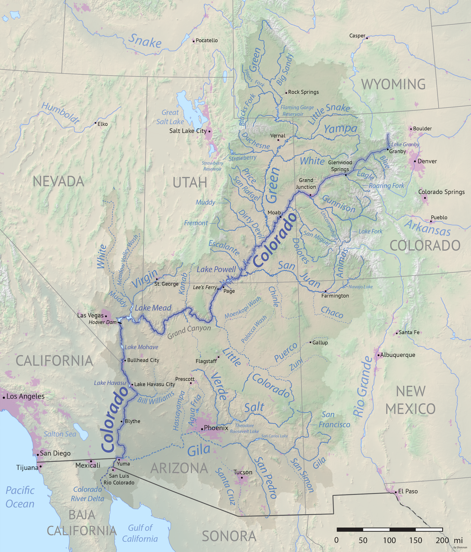
Colorado River Basin with out of basin uses shown in magenta. Credit: Wikipedia.org
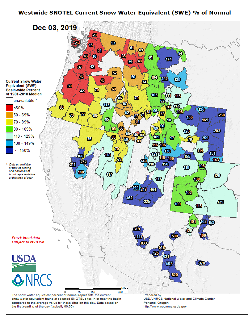
As of Monday’s Natural Resources Conservation Service (NRCS) update, Colorado statewide snowpack levels were running at 117% of the season-to-date levels, meaning that statewide snow levels are slightly above average.
Each of Colorado’s eight major river basins were running above average, according to the NRCS update. That’s also an indication that the overall seasonal snowfall has been fairly well distributed so far this winter, with northern Colorado receiving the brunt of October and early November snowstorms, and southern Colorado getting most of its snow in the last two to three weeks.
The main driver behind the recent uptick in snow levels? A needed whopper of a snowstorm in southwest Colorado late last week. Some parts of the drought-stricken San Juan mountains saw as much as 3.5 feet of snowfall from last week’s storm. That helped boost snowpack percentages in southern Colorado well above average, while also boosting overall statewide levels…
Snowpack levels so far this winter are almost identical to the start of last winter’s season-to-date totals. That said, last year’s huge snowpack mostly came from an unusually active spring…
The fast start to the winter season generally signals good news for most statewide interests. It’s certainly a big positive for the ski industry, reservoir levels and the drought in southwest Colorado, all of which will likely be rooting on a continuation of this winter’s fast start.
Westwide SNOTEL basin-filled map December 3, 2019 via the NRCS.
And just for grins here are the early December Colorado statewide maps for the past few years.
Statewide basin-filled snowpack map December 2, 2019 via the NRCS.
Colorado snowpack basin-filled map December 10, 2018 via the NRCS.
Statewide basin-filled map December 4, 2017 via the NRCS.
Statewide snowpack December 6, 2016 via the NRCS.
Statewide snowpack map December 1, 2015 via the NRCS
Colorado Statewide snowpack map December 2, 2014 via the NRCS
Statewide Snowpack Map December 10, 2013 via the NRCS