These wetlands, located on a 150-acre parcel in the Homestake Creek valley that Homestake Partners bought in 2018, would be inundated if Whitney Reservoir is constructed. The Forest Service received more than 500 comments, the majority in opposition to, test drilling associated with the project and the reservoir project itself. Photo credit: Heather Sackett/Aspen Journalism
The U.S. Forest Service has been inundated with more than 500 online comments — the vast majority in opposition — to a geophysical study and drilling by the cities of Aurora and Colorado Springs to determine the feasibility of a second reservoir in the Homestake Creek drainage, including objections from nearby towns and a local state senator.
The geophysical study and the drilling are the next step in the lengthy process of developing a reservoir on lower Homestake Creek.
The mayors of Red Cliff and Minturn signed and submitted separate but identical letters questioning the legality of drilling 10 boreholes on Forest Service land near the Holy Cross Wilderness Area, which is six miles southwest of Red Cliff, to see whether soil and bedrock can support a dam for what would be known as Whitney Reservoir. Avon’s attorney has asked for a public comment extension to Aug. 4 so that it can hold a hearing.
“A Whitney Reservoir would irreparably change and harm our community,” Minturn Mayor John Widerman and Red Cliff Mayor Duke Gerber wrote in their letters, submitted June 30. “We are paying close attention to these proposals, other moves by Homestake Partners and the public controversy. This categorical exclusion is rushed, harmful and unlawful.”
Operating together as Homestake Partners, the cities of Aurora and Colorado Springs own water rights dating to the 1950s that, under the 1998 Eagle River Memorandum of Understanding (MOU), give them the basis to pursue developing 20,000 acre-feet of water a year from the Western Slope. They’ve been studying four potential dam sites in the Homestake Valley several miles below the cities’ existing Homestake Reservoir, which holds 43,600 acre-feet of water.
The smallest configuration of Whitney Reservoir, if deemed feasible and ultimately approved, would be 6,850 acre-feet, and the largest would be up to 20,000 acre-feet. The reservoir, on lower Homestake Creek, would pump water up to Homestake Reservoir, about five miles upstream, then through a tunnel under the Continental Divide to Turquoise Reservoir near Leadville.
In 2018, Homestake Partners paid $4.1 million for 150 acres of private land, which it leases back to the former owner for a nominal fee. That land, which would be inundated to accommodate a large portion of Whitney Reservoir’s surface area, is braided with streams and waterfalls and is lush with fens and other wetlands. It’s also home to a cabin once used as an officers quarters for the famed 10th Mountain Division of the U.S. Army. The site is not far from Camp Hale, between Red Cliff and Leadville, where soldiers trained for mountain warfare during World War II.
This cabin, once used by the 10th Mountain Division of the U.S. Army, sits on a 150-acre parcel owned by Homestake Partners. The site of the proposed Whitney Reservoir is near Camp Hale, between Red Cliff and Leadville. Photo credit: David O. Williams/Aspen Journalism
Eagle River MOU
The Eagle River MOU is an agreement between Aurora and Colorado Springs and a bevy of Western Slope water interests. The Colorado River Water Conservation District, Eagle River Water & Sanitation District, Upper Eagle Regional Water Authority, and Vail Resorts are collectively defined in the MOU as the Reservoir Company. None of those entities submitted comments to the Forest Service on the drilling proposal. And according to Diane Johnson, communications and public affairs manager for the ERWSD and UERWA, none are helping to pay for the feasibility study and none are involved in the reservoir project, except to the degree that it is tied to the MOU.
The MOU provides for 20,000 acre-feet of average annual yield for the cities. “Yield” refers to a reliable supply of water. In some cases, yield equates to storage in a reservoir, but yield can also be created by other methods, such as pumping water uphill from a smaller, refilled reservoir, which is an option being studied by the cities on lower Homestake Creek. The MOU also provides for 10,000 acre-feet of “firm dry year yield” for the Western Slope entities in the Reservoir Company, and firm dry year yield means a reliable supply even in a very dry year. Those entities have developed about 2,000 acre-feet of that allocated firm yield in Eagle Park Reservoir, and it’s not yet clear whether the Whitney Reservoir project would help them realize any additional yield.
“The short answer is we support (Homestake Partners’) right to pursue an application for their yield,” Johnson said. “We trust the permitting process to bring all impacts and benefits to light for the community to consider and weigh in total.” .
Jim Pokrandt, director of community affairs for the River District, declined to comment on the investigatory test work, saying only, “Yes, we have signed the MOU. That said, … we are not participating in the Whitney Creek effort.”
Besides Homestake Partners and the Reservoir Company, the MOU was signed by the Climax Molybdenum Company. The two private companies signed onto the MOU — Vail Resorts and Freeport-McMoRan (Climax) — also declined to comment on either the drilling study or Whitney Reservoir.
Under the MOU, various parties can pursue projects on their own, and the other parties are bound to support those efforts, but only to the degree that a proposed project meets the objectives of the MOU, including whether a project “minimizes environmental impacts.”
Many of the 520 online comments as of the June 30 deadline objected to testing for the possibility of a dam, expressing concern for the complex wetlands in the area, but most of the comments also strongly condemn the overall project: a potential future Whitney Reservoir.
The cities are trying to keep the focus on the test drilling.
“This is simply a fatal-flaw reservoir siting study that includes subsurface exploration, and it’s basically just to evaluate feasibility of a dam construction on lower Homestake Creek,” said Maria Pastore, Colorado Springs Utilities’ senior project manager for water resource planning. “It’s simple exploratory work to determine if we can even go ahead with permitting and design.”
Marcia Gilles, acting ranger for the Eagle-Holy Cross District, said her office will continue accepting comments at any time during the ongoing analysis of the geophysical study despite the June 30 deadline. She added that if the Forest Service concludes there are no “extraordinary circumstances,” she can render a decision using what is known as a categorical exclusion and then issue a special-use permit as soon as August. A categorical exclusion requires less environmental scrutiny than other forms of analysis.
“At this time, the proposed action appears to be categorically excluded from requiring further analysis and documentation in an environmental assessment (EA) or environmental impact statement (EIS),” Gilles said. “Should the environmental analysis find extraordinary circumstances, the Forest Service would proceed to analyzing the project in an EA or EIS.”
State Sen. Kerry Donovan, a Vail Democrat, disagrees. She wrote to the Forest Service on June 30: “I … strongly urge you not to categorically exclude this project from (National Environmental Policy Act) analysis. I cannot express how sternly the citizens of my district oppose water diversion projects to Front Range communities.” Her district encompasses seven Western Slope counties, including Eagle, where the dam would be located.
Donovan called the proposed investigation — which would require temporary roads, heavy drilling equipment, continuous high-decibel noise, driving through Homestake Creek and use of its water in the drilling process — an affront to the “Keep It Public” movement, which advocates for effective federal management on public lands.
These wetlands in the Homestake Creek valley are near the site of the proposed Whitney Reservoir. The Forest Service is considering whether to issue a permit for drilling and a geotechnical study to test whether the site would support a dam. Photo credit: Heather Sackett/Aspen Journalism
Drilling impacts
If approved by the Forest Service for a special-use permit, Homestake Partners would send in crews on foot to collect seismic and other geophysical data later this summer or fall. Crews with heavy equipment would then drill 10 boreholes up to 150 feet deep in three possible dam locations on Forest Service land. The drilling would take place on Forest Service land but not in a wilderness area.
Crews would use a standard pickup truck, a heavy-duty pickup pulling a flatbed trailer, and a semi-truck and trailer that would remain on designated roads and parking areas, with some lane closures of Homestake Road and dispersed campsites possible.
For off-road boring operations, crews would use a rubber-tracked drill rig, a utility vehicle pulling a small trailer, and a track-mounted skid steer. The drill rigs are up to 8 feet wide, 22 feet long and 8 feet high, and can extend up to 30 feet high during drilling, possibly requiring tree removal in some areas. The rigs would also have to cross Homestake Creek and some wetland areas, although crews would use temporary ramps or wood mats to mitigate impacts.
According to a technical report filed by Homestake Partners, the subsurface work is expected to take up to five days per drilling location, or at least 50 days of daytime work only. However, continuous daytime noise from the drilling could approach 100 decibels, which is equivalent to either an outboard motor, garbage truck, jackhammer or jet flyover at 1,000 feet. If work is not done by winter, crews have up to a year to complete the project and could return in 2021.
The drilling process would use several thousand gallons of Homestake Creek water per day that engineers say “would have negligible impacts on streamflow or aquatic habitat. Water pumped from Homestake Creek during drilling would amount to less than 0.01 (cubic feet per second), a small fraction of average flows,” according to a technical report included with application materials.
Homestake Partners would avoid wetlands as much as possible during drilling, but “where temporary wetland or waters disturbance is unavoidable, applicable 404 permitting would be secured from the U.S. Army Corps of Engineers.” Crossing of Homestake Creek would occur in late summer or fall when streamflows are low, and no drilling would occur in wetlands.
While no permanent roads would be built for the drilling, temporary access routes would be necessary and reclaimed as much as possible.
“Access routes would be selected to reduce surface disturbance and vegetation removal, and to avoid identified or potential unexploded ordnances (UXOs) discovered during field surveys,” according to the technical report. The 10th Mountain Division used the area for winter warfare training during WWII.
Another concern cited in the report is the potential impact to Canada lynx. Listed as threatened under the Endangered Species Act, “only Canada lynx has potential habitat in the vicinity of the project area,” according to the report. “No impacts on lynx are anticipated from the proposed work because much of the activity would occur near Homestake Road, a well-traveled recreation access road. Work would be conducted over a short period (approximately five to six weeks) and impacts on potential habitat would be negligible.”
The vast majority of comments from a variety of environmental groups and concerned citizens focused on potential impacts to the area’s renowned wetlands and peat-forming fens, which the project proponents say they will avoid as much as possible. So far, Gilles said she is not aware of any legal challenges to the project.
Two prominent local conservation groups — Eagle Valley Land Trust and Eagle River Watershed Council — submitted comments to the Forest Service expressing serious reservations about both the drilling and the possibility of a dam.
“Geophysical exploration has an obvious significant nexus and direct relation to additional future actions, i.e., dam construction, which may in time massively impact the Eagle River watershed — regardless of whether the future actions are yet ripe for decisions,” ERWC officials wrote.
This map shows the location of test holes Homestake Partners plans to drill as part of its geotechnical investigation into the feasibility of a dam site in the Homestake Creek valley. The Forest Service has received more than 500 comments, most of them in opposition to, the drilling and the overall reservoir project. Credit: USFS via Aspen Journalism
Wilderness boundary
Even if the test drilling returns favorable results for a reservoir project, there is another obstacle that Homestake Partners will have to clear if they want to move forward with two iterations of the project: a wilderness-boundary change, which would require an act of Congress and the president’s signature.
The Whitney Reservoir alternatives range from 6,850 to 20,000 acre-feet and in some configurations would require federal legislation, which the cities are working to draft, requesting a boundary adjustment for the nearby Holy Cross Wilderness Area. The largest Whitney proposal would require an 80-acre adjustment, while an alternative location, lower down Homestake Creek, would require a 497-acre adjustment.
White River National Forest Supervisor Scott Fitzwilliams discounts the notion that his agency should reject outright the test-drilling application, as some environmental groups have suggested, until the wilderness-boundary issue is determined. Although some local and state lawmakers have said they are against shifting a wilderness boundary, Fitzwilliams said it’s still too soon for him to take up the wilderness issue.
“These are test holes,” Fitzwilliams said of the drilling, which is intended to see whether the substrata are solid enough for a dam and reservoir. “Going to get a (wilderness) boundary change is not a small deal for them, so why would you do it if you find fatal flaws? That’s a red herring.
“I understand it; nobody wants to see a dam in the Homestake drainage. I get that. But it just seems prudent to do (the drilling) to see if there’s any reason to go further.”
Aspen Journalism is collaborating with the Vail Daily and other Swift Communications newspapers on coverage of water and rivers. This story was published online by Vail Daily on July 9, 2020 and in its print edition on July 10. The early online version of the story was edited to clarify aspects of the Eagle River MOU.
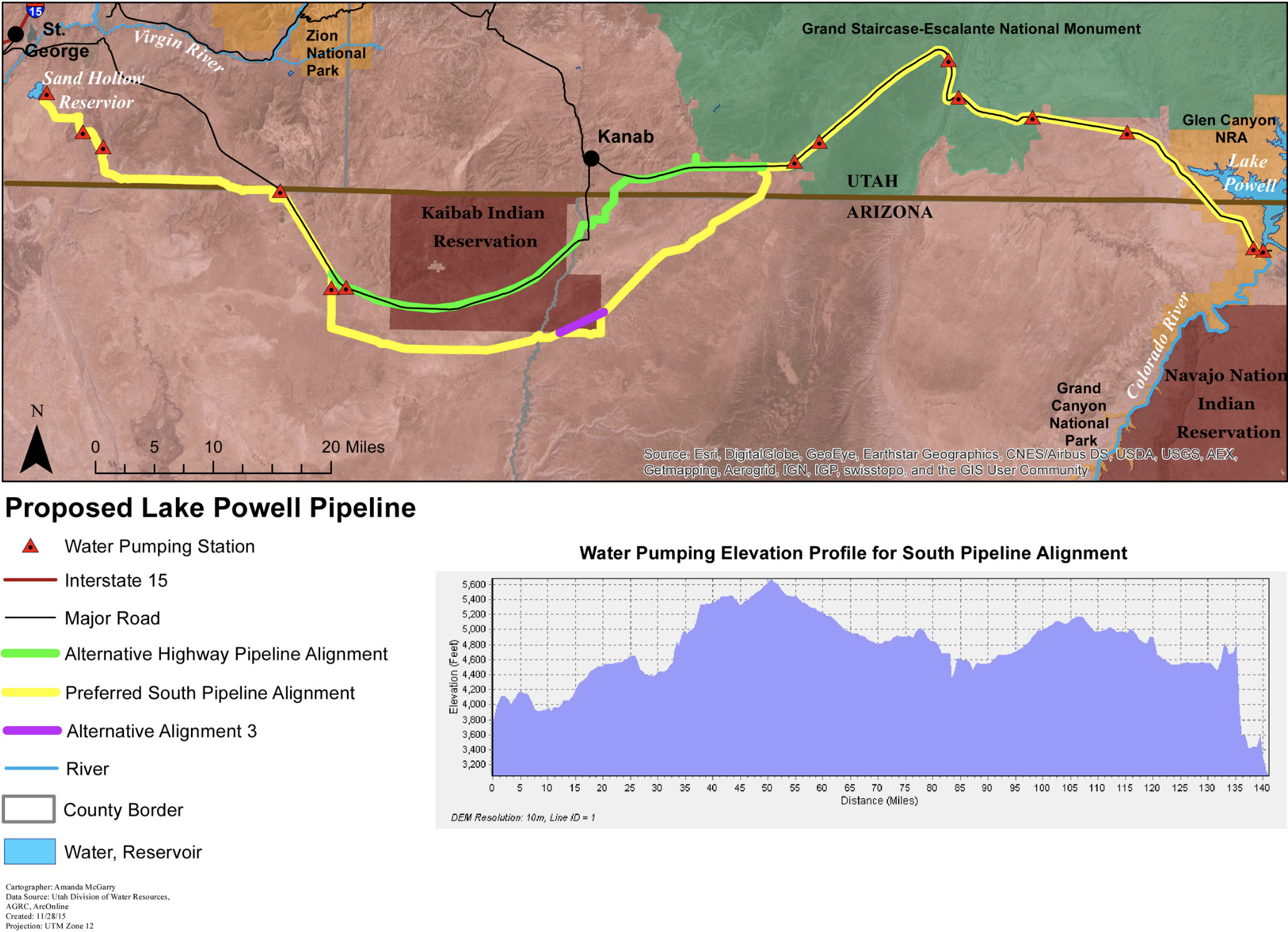
Draft plans for the Lake Powell Pipeline have the project running through sacred and culturally significant lands to the Kaibab Band of Paiute Indians.
The pipeline, which is currently under public review, has two proposed routes — one that runs through the Kaibab Indian Reservation and one that runs along its southern border. The Kaibab Tribe opposes both of these routes, according to a document from the tribe in the project’s draft environmental impact statement.
Proponents of the pipeline prefer the southern route, which bypasses the reservation.
Chairwoman of the tribal council, Ona Segundo, said that doesn’t mean the tribe’s lands wouldn’t be disturbed. The tribe opposes the project as a whole, she said, but would prefer the highway route that follows Arizona State Route 389…
“Yes, the people in Washington County and that area are in need of that water, however, they also need to realize that the Kaibab Paiute Tribe are here,” [Ona Segundo] said. “We’ve been here for millenia and we will continue to be here. We feel it is our duty to protect this area.”
This $2+ billion project would pump 28 billion gallons of water 2,000 feet uphill across 140 miles of desert to provide just 160,000 residents in Southwest Utah with more water. Graphic credit: Utah Rivers Council
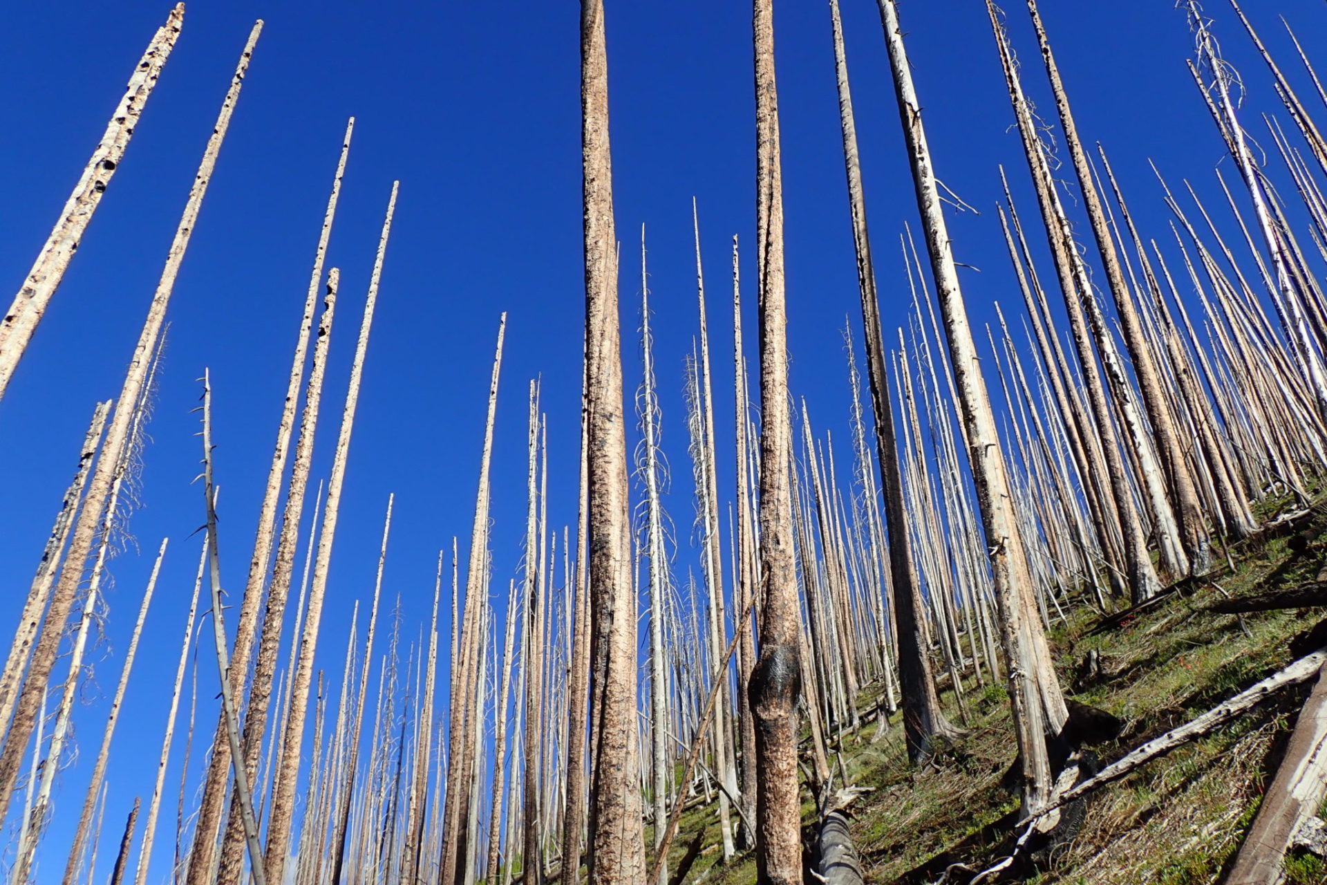
The West Fork fire complex of 2013 was composed of three fires that burned more than 109,000 acres on mostly public lands managed by the Rio Grande and San Juan National Forests. Photo: Jonathan Coop, Western Colorado University via Colorado State University
One of Jonathan Coop’s first vivid memories as a child was watching the flames of the 1977 La Mesa Fire in north-central New Mexico. The human-caused fire burned more than 15,000 acres of pine forests in the Bandelier National Monument and areas surrounding the Los Alamos National Laboratory.
Now a forest ecologist and professor at Western Colorado University, Coop studies the ecological effects of fire on forests in the Southwest United States. He’s also the lead author of a new scientific synthesis about how wildfires drive changes in forest vegetation across the United States. Sean Parks — research ecologist with the USDA Forest Service, Rocky Mountain Research Station — and Camille Stevens-Rumann, assistant professor in the Department of Forest and Rangeland Stewardship at Colorado State University, are co-authors of the synthesis.
The new paper, with contributions from more than 20 researchers, uncovers common themes that scientists are reporting, including increasing impacts of wildfires amid climate change from the borderlands of Mexico and Arizona to the boreal forests of Canada.
Following high-severity fire, scientists have found forest recovery may increasingly be compromised by lack of tree seed sources, warmer and drier post-fire climate and more frequent reburning. [ed. my emphasis]
“In an era of climate change and increasing wildfire activity, we really can’t count on forests to come back the way they were before the fire,” said Coop. “Under normal circumstances, forest systems have built-in resilience to disturbance – they can take a hit and bounce back. But circumstances aren’t normal anymore.”
The loss of resilience means that fire can catalyze major, lasting changes. As examples, boreal conifer forests can be converted to deciduous species, and ponderosa pine forests in the southwest may give way to oak scrub. These changes, in turn, lead to consequences for wildlife, watersheds and local economies.
‘Assisted migration’ an option in some cases, places
Researchers said that in places where the most apparent vegetation changes are occurring, such as the Southwest U.S. and in Colorado, land managers are already exploring ways to help forests adapt by planting tree species that are better suited to the emerging climatic conditions following severe fire.
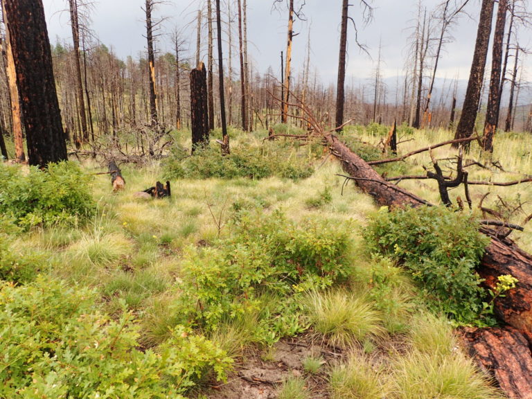
A forest after the Las Conchas fire in northern New Mexico. Photo: Jonathan Coop, Western Colorado University via Colorado State University
“In places where changes are not quite so visible, including Montana and Idaho, those conversations are still happening,” said Stevens-Rumann. “In these large landscapes where trees are not coming back, you have to start getting creative.”
Parks, who often uses data collected in protected areas to study wildfire patterns, causes and consequences, said some fires can be good, creating openings for wildlife, helping forests rejuvenate and reducing fuel loads.
“However, some fires can result in major changes to the types of vegetation,” he said, adding that this is particularly true for high-severity wildfires when combined with the changing climate. “Giving managers information about where and how climate change and wildfires are most likely to affect forest resilience will help them develop adaptation strategies to maintain healthy ecosystems.”
Stevens-Rumann said that land managers have largely continued to operate in the way they’ve done in the past, replacing fire-killed trees with the same species. “Given the effects of climate change, we need to start being much more creative,” she said. “Let’s try something different and come up with solutions that allow natural processes to happen and interact with landscapes in different ways.”
Coop said that ecologists and managers are beginning to develop a suite of approaches to increase forest resilience in an era of accelerating change.
One approach that he said he’s partial to is allowing fires to burn under benign or moderate fire weather conditions – similar to what happens in a prescribed burn – which results in forests that are less prone to high-severity fire because of reduced fuel loads and patchy landscapes. This is also known as managing wildfire for resource objectives, an approach that researchers said is cost-efficient, allowing managers to treat more acres.
“Increasingly, we’re realizing you either have the fires you want and can influence or you’re stuck with these giant fires where, like hurricanes, there’s no shaping their path,” said Coop.
Loss of forests is personal
For many of the researchers involved in this synthesis, the issues being analyzed are personal.
Before becoming a scientist, Stevens-Rumann spent three years on a USDA Forest Service “Hotshot” crew, specializing in fighting fires in hard-to-access and dangerous terrain. Parks grew up in Colorado and California and acknowledges seeing changes in the forests and landscapes he grew up with.
Coop said he’s seen an incredible amount of forest lost in the Jemez Mountains where he grew up. The La Mesa fire was only the first in a series of increasingly large and severe fires, culminating with the 140,000-acre Las Conchas fire in 2011. Within the footprint of Las Conchas, less than a quarter of the landscape is still forested.
“Seeing these things unfold over my lifetime, I don’t know if I ever really could have imagined it,” he said. “I’ve borne witness to these very dramatic changes unfolding in the one place that I really know best on Earth.”
Click through to read, what Julia Steinberger describes ad, “…less of a blog post, and more of a howl.” Here’s an excerpt:
“_” : this is our unit of time, and it’s 1000 years long.
_ is 10 long human lifespans, 40 generations, the time separating us from the first millennium and the Middle Ages in European history, when Canute of Denmark ruled Britain, before Marco Polo traveled the Silk Road. It’s a long time by any human account: twice the duration of the Roman Empire.
_____ is 5’000 years. It’s the age of the oldest known living tree, Methuselah, in the Californian White Mountains.
____________ is 12’000 years. It’s the time span separating us from the last ice age. This time is the time during which humans slowly selected plants, developed agriculture, cities, writing: anything we would call civilization. It is the time when humans thrived, cultures multiplied, our population grew. This clement and stable climate interval, which sheltered us and the plants we depend upon to live so well, is known as the Holocene. Gaze upon that interval fondly, for it is already in our past…
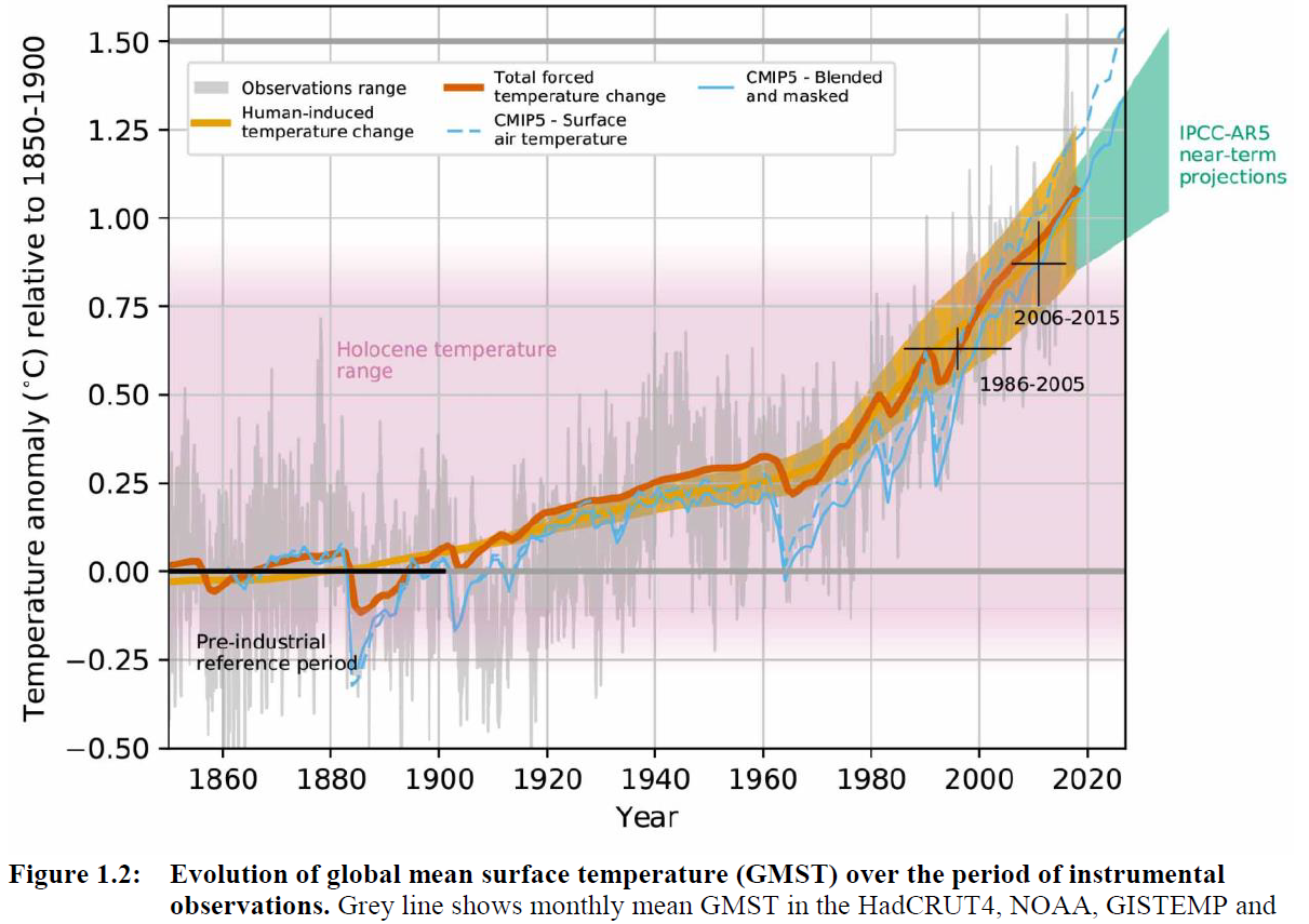
Figure 1.2 from the IPCC’s Special Report on 1.5 degrees, showing that we have already left the temperature range of the Holocene.
If CO2 is so correlated with climate, why are we not already experiencing the temperatures and sea levels of the Pliocene, and witnessed by faraway Homo Habilis, with their almost-human eyes? Professor Gavin Foster, co-author of the Nature study, puts it this way: “The reason we don’t see Pliocene-like temperatures and sea-levels yet today is because it takes a while for Earth’s climate to fully equilibrate (catch up) to higher CO2 levels and, because of human emissions, CO2 levels are still climbing. Our results give us an idea of what is likely in store once the system has reached equilibrium.”
Time lags for equilibration vary between Earth systems: climate temperatures will catch up with the Pliocene with in a few decades, sea levels within a few centuries. But it gets worse. Because not only have we left the agriculture-sheltering Holocene. Not only have we zoomed through Pliocene the span than 1 human lifetime (reminder: we have no evidence that the large scale agriculture we depend upon, in our billions, for survival, is possible in this new climate. Cheers.). We are still going. We are accelerating, in fact, with concentrations of CO2 increasing faster and faster every year.