Drought news: The weak Southwest #Monsoon…left the #FourCorners States bereft of significant rainfall but is expected to ramp up

Click on a thumbnail graphic to view a gallery of drought data from the US Drought Monitor.

Click here to go to the US Drought Monitor website. Here’s an excerpt:

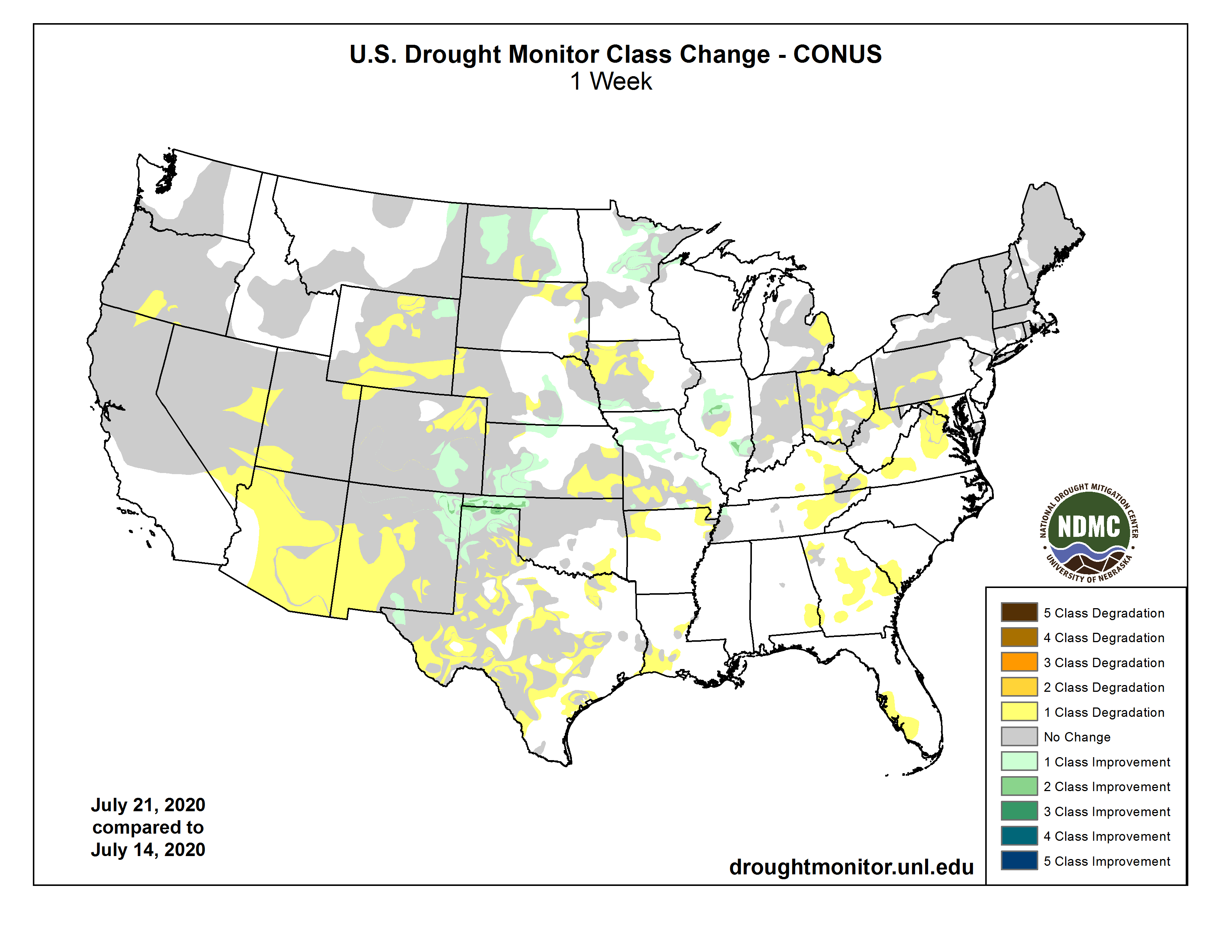
This Week’s Drought Summary

High pressure dominated the southern half of the contiguous U.S. (CONUS) during this U.S. Drought Monitor (USDM) week. Upper-level weather systems tracked across the U.S.-Canadian border, dragging surface lows and fronts along with them. The frontal systems tapped Gulf of Mexico moisture to drop locally heavy rain across parts of the Plains to Midwest, while convective thunderstorms peppered coastal areas of the Gulf. The high-pressure ridge inhibited precipitation across much of the southern Plains to Southeast, and across most of the West. It also kept temperatures unusually hot, with daily maximums exceeding 90 degrees F across the South throughout the week and across much of the West for most of the week. The excessive heat spread into the northern Plains, Midwest, and into the Northeast as the week wore on. The persistent heat increased evapotranspiration, which dried soils and stressed crops and other vegetation. The locally heavy rains brought temporary relief from the heat and dryness, but only for those areas in the Plains and Midwest lucky enough to receive the rain…

High Plains

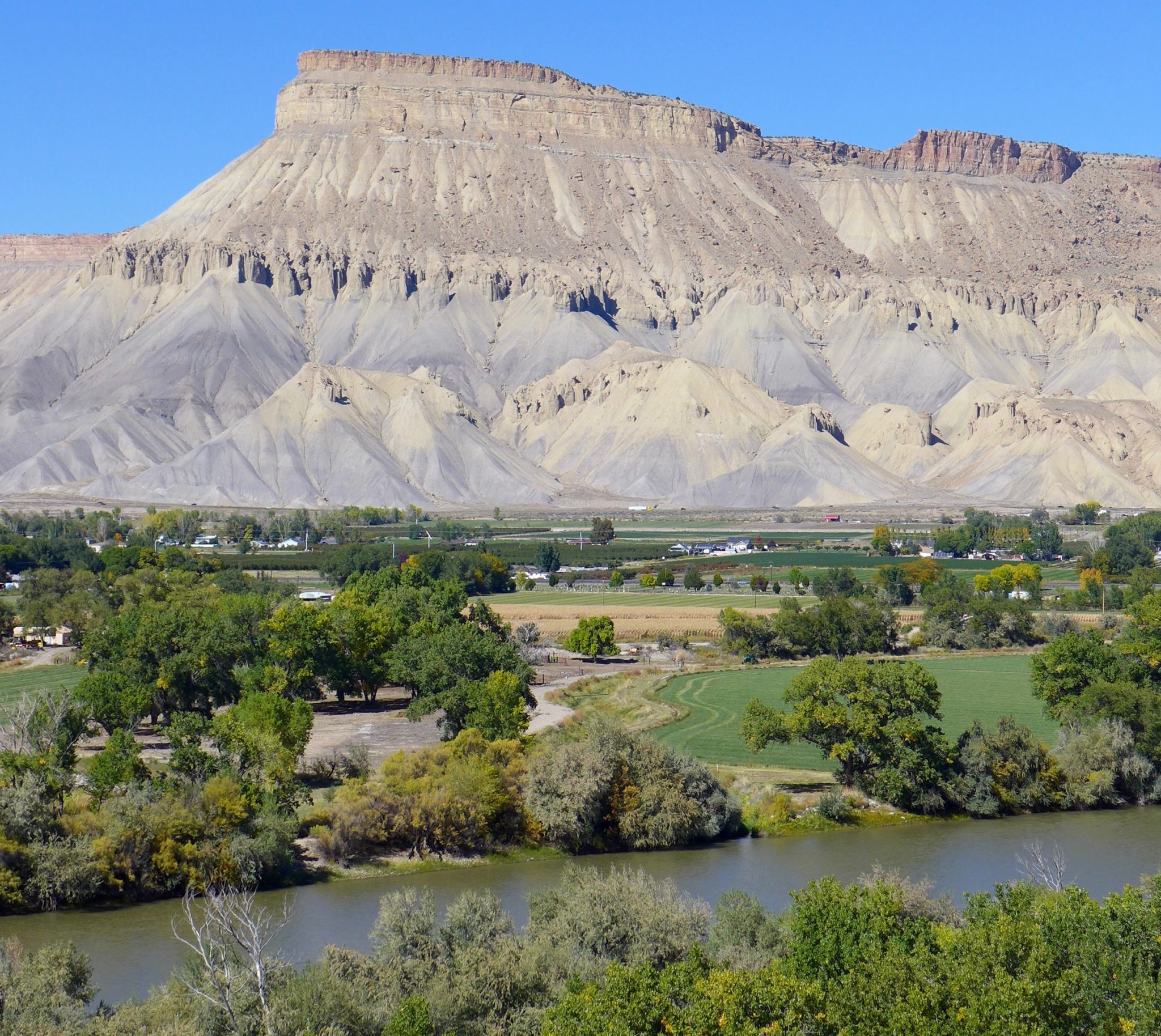
Areas of 2+ inches of rain were widespread across Kansas, eastern North Dakota, and parts of Nebraska, with locally over 5 inches in northeast Kansas and southeast Nebraska. But the spigot remained off across most of Wyoming and western and northern parts of Colorado. Drought contracted where the beneficial rains fell, including southeast Colorado, western Kansas to parts of Nebraska, northeast Wyoming, and parts of North Dakota. But drought and abnormal dryness expanded where it continued dry, including eastern Kansas, northeastern Colorado to adjoining parts of Nebraska, northeastern Nebraska, parts of the Dakotas, and especially in Wyoming. Moderate to severe drought expanded in, and extreme drought was added to, Wyoming…

West

Eastern Montana and parts of New Mexico received notable amounts of rain (half an inch or more), with scattered light showers over parts of Arizona, but most of the West was bone dry this week. Drought or abnormal dryness contracted in northeastern Montana and parts of eastern and southern New Mexico. But the weak Southwest Monsoon otherwise left the Four Corners States bereft of significant rainfall, so drought and abnormal dryness expanded in central, western, and southern New Mexico; across much of Arizona; and in parts of Nevada, Utah, and Oregon…

South

Two to locally over 5 inches of rain fell across parts of the Texas panhandle and northwest Oklahoma, and along parts of the Texas to Mississippi coast. But it was another dry week across much of Texas to eastern Oklahoma to northern Mississippi and Tennessee. Moderate to extreme drought contracted in the wet panhandles of Texas and Oklahoma, but moderate to severe drought expanded in other parts of Texas, with pockets of extreme drought added to southwestern Texas and southwestern Oklahoma. Abnormal dryness or moderate drought expanded further east across parts of Arkansas, Louisiana, and Tennessee…

Looking Ahead

For July 23-27, the Southwest Monsoon is predicted to fire up, dropping locally 2 or more inches of rain across parts of the Four Corners states, and up to an inch of rain is forecast over parts of the northern Rockies. Otherwise, the West is expected to be mostly dry. A tropical system may bring up to 4 inches of rain along the western Gulf of Mexico coast and up to 2 inches over southern Florida, while frontal systems could leave one to 3 inches of rain over parts of Nebraska, the northern Plains to western Great Lakes, parts of the Midwest to Appalachians, the Mid-Atlantic coast, and parts of the Northeast. In between these systems, large swaths of the southern and central Plains to Southeast and southern Great Lakes have less than an inch of rain in the forecast. Temperatures are predicted to continue warmer than normal for most of the CONUS. The outlook for July 28-August 1 calls for wetter-than-normal conditions across the Southwest to Mid-Atlantic region and most of Alaska, and drier-than-normal conditions in the Pacific Northwest to Great Basin, northern Plains to Great Lakes, and much of the Northeast, as well as southeast Alaska. Odds favor warmer-than-normal conditions for most of the West, northern Plains to Great Lakes, eastern Gulf Coast, all along the Eastern Seaboard, and across the Aleutians in Alaska. Cooler-than-normal temperatures are likely across the southern to central Plains and across most of Alaska.

US Drought Monitor one week change map ending July 21, 2020.

July #Climate Briefing: La Niña Watch Issued — IRI #ENSO

Typical La Nina weather patterns over North America via NOAA.

Click here to go to the IRI website:

In mid-July, the sea-surface temperatures were slightly below average but in the ENSO-neutral range, and some atmospheric indicators showed neutral conditions while others leaned slightly toward La Niña. A new set of model runs predicts that cool-neutral or weak La Niña conditions are most likely from late Northern Hemisphere summer through early winter, with a 50-55% probability for weak La Niña for the August-October through October-December seasons. This outlook calls for just slightly lower chances for La Niña from late summer to early winter as the official ENSO forecast issued July 9, which used both models and human judgment, and which now carries a La Niña watch.

Weston Anderson provides the briefing summary:

https://www.youtube.com/watch?v=UHyoN9clt88&feature=emb_logo

Notice of Stakeholder Meeting on Instream Flow Rules Revisions to Implement HB20-1157 — @CWCB_DNR

Coal Creek near Redstone. Photo credit: Heather Sackett/Aspen Journalism

From email from the Colorado Water Conservation Board (Rob Viehl):

The CWCB staff has drafted proposed revisions to the Rules Concerning Colorado’s Instream Flow and Natural Lake Level Program (“ISF Rules”). The revisions to the ISF Rules will: (1) address the rulemaking requirements of HB20-1157; (2) update a reference to the CWCB’s website; and (3) update references to Colorado Parks and Wildlife.

Staff will hold an informal stakeholder meeting on Monday, August 3, 2020 from 1:00 p.m. – 4:00 p.m. to discuss the draft ISF Rules revisions. Staff invites interested parties to submit written comments on the draft ISF Rules revisions by emailing them to linda.bassi@state.co.us. Please submit comments by COB on July 29, 2020. Any comments received by that date will be posted on the CWCB website prior to the August 3 meeting. Written comments may be submitted after July 29, 2020, but might not be posted on the website prior to the August 3 meeting. At the meeting, CWCB staff and attendees will discuss the draft ISF Rules revisions, comments received prior to the meeting, and comments expressed at the meeting. If you have questions, contact Linda Bassi at linda.bassi@state.co.us or (303) 866-3441, ext. 3204.

Meeting Details:
Mon, Aug 3, 2020 1:00 PM – 4:00 PM (MDT)

Please join the meeting from your computer, tablet or smartphone.
https://global.gotomeeting.com/join/454890797
When you log in to the meeting, please provide your full name for our records.

You can also dial in using your phone.
United States: +1 (224) 501-3412

Access Code: 454-890-797

#ColoradoRiver District will ask voters for tax increase — @AspenJournalism #COriver #aridification

A boater paddles the Roaring Fork River near Carbondale in May. The Colorado River Water Conservation District, which advocates to keep water on the Western Slope, will ask voters for a tax increase in November. Photo credit: Brent Gardner-Smith/Aspen Journalism

From Aspen Journalism (Heather Sackett):

The Colorado River Water Conservation District will ask voters this November to approve a property-tax increase that would double its budget, from about $4 million to $8 million.

After a lengthy discussion at Tuesday’s regular quarterly meeting, River District board members voted to move ahead with a ballot question asking voters to raise its property taxes from a quarter-mill to a half-mill. That works out to 50 cents per $1,000 of assessed value. One mill is the equivalent of $1 per $1,000 of assessed value.

According to numbers provided by the River District, the mill levy would increase per year to $40.28 from $18.93 for Pitkin County’s median home value, which at $1.13 million is the highest in the district.

The district in April had put off making a decision on moving forward with a ballot question until July due to concerns about asking voters for more money during the economic crisis caused by COVID-19. Officials were comfortable moving forward, however, after recent polling showed continued support for the measure.

According to the resolution approving the ballot language, the money will be used for fighting to keep water on the Western Slope; protecting adequate water supplies for Western Slope farmers and ranchers; protecting sustainable drinking-water supplies; and protecting fish, wildlife and recreation by maintaining river levels and water quality.

“This is one of the most consequential decisions the district has made in some time,” said board president Dave Merritt, who represents Garfield County. “This is going to be really important to the future of the River District to take us into the next era.”

The district has seen its revenue stream decline in recent years due to shrinking tax revenue from the fossil-fuel industry and lower residential assessments as a result of the state’s Gallagher and Taxpayer’s Bill of Rights amendments. As a result, the district has reduced its staff by four positions, suspended a grant program and reduced its vehicle fleet.

The district got more specific in the spring about what it would do with the money in a fiscal implementation plan. About 86% would go toward water projects backed by local communities and basin roundtables. Examples could include environmentally focused projects such as forest restoration on the Yampa River, infrastructure projects such as rehabilitation for the Grand Valley Roller Dam, and dam and reservoir projects such as the White River Storage Project. The district would not use the money to create new staff positions.

The Glenwood Springs-based River District, which was created in 1937 to protect and develop water supplies in western Colorado, spans 15 counties: Grand, Summit, Eagle, Pitkin, Rio Blanco, Routt, Moffat, Garfield, Mesa, Delta, Montrose, Ouray, Gunnison, Hinsdale and Saguache.

Pitkin County’s representative, County Attorney John Ely, was the lone “no” vote for the ballot measure. He said the fiscal implementation plan should include a promise that the River District will work with local elected officials on water projects, especially since River District board members would be the ones allocating project funding — and they are not elected to their positions.

“Having that type of commitment in the plan, I think that would go a long way in allaying that type of a concern,” Ely said.

The River District added the language Ely requested to the fiscal implementation plan.

At the suggestion of some agriculture-dependent counties, including Mesa County, River District General Manager Andy Mueller added language to the ballot question that says the district will not utilize the additional funds for paying to fallow irrigated agriculture. Montrose County representative Marc Catlin pushed to go a step further, suggesting that the definition of fallowing include permanent programs, as well as voluntary, temporary and compensated programs. The state of Colorado is currently looking into a program that could pay irrigators on a voluntary, temporary and compensated basis to fallow fields in order to leave more water in the river.

“I think we ought to tie it to this ballot because 10 years from now, somebody might have a completely different idea of what fallowing might mean,” Catlin said.

But other directors cautioned against getting too wordy in the question, which could confuse voters, especially since a recent survey found strong support for a more simply stated proposal.

“I would just be happier if we kept this closer to what was polled and simpler,” said Martha Whitmore, who represents Ouray County.

The Colorado River flows through the Grand Valley near Grand Junction. The Colorado River Water Conservation District board of directors voted Tuesday to ask voters for a mill levy increase in November. Photo credit: Brent Gardner-Smith/Aspen Journalism

Survey finds support

The River District hired Lori Weigel from Arvada-based consultant New Bridge Strategy for another round of voter polling, which surveyed 600 district residents between June 25 and July 2. If the election were held tomorrow, 63% of those surveyed said they would definitely vote in favor of a tax increase.

“That 63% is really the critical number there,” Weigel said. “It’s pretty rare that we see support levels this high.”

The district had previously found similarly high levels of support — 65% — when Weigel surveyed voters in mid-March. Some board members worried that because the survey coincided with the beginning of the COVID-19 pandemic, the results would no longer be valid. But survey results this time around showed continued support for a tax increase.

“I think we can have a great deal of confidence in this data,” Weigel said. “(Support) has not shifted significantly. Water is something that is important to people. Water is sort of a constant.”

Aspen Journalism is a local, nonprofit, investigative news organization covering water and rivers in collaboration with The Aspen Times and other Swift Communications newspapers. This story ran in the July 22 edition of The Aspen Times.

Denver’s Highline Canal a study in using something old to solve new problem — @WaterEdCO

Old cottonwoods line the banks and trails of the historic Highline Canal, which is being converted into an ultra modern stormwater system even as its trail systems continue to serve metro area residents. July 21, 2020 Credit: Jerd Smith via Water Education Colorado

From Water Education Colorado (Caitlin Coleman):

Infrastructure built more than a century ago still endures, but some of Colorado’s old irrigation ditches have been repurposed to meet the moment. The High Line Canal—a 71-mile-long former irrigation conveyance turned greenway and stormwater filtration tool—winds its way through the Denver metro area as an artery of infrastructure boasting a story of adaptation.

The canal, built in the 1880s to move irrigation water, was purchased by Denver Water in the 1920s. But the metro area changed around it. By the 1960s, people were sneaking onto the service road alongside the ditch and using it as a walking trail, says Harriet Crittenden LaMair, executive director of the High Line Canal Conservancy, a nonprofit working to preserve, protect and enhance the canal.

By the 1970s, municipalities and special districts began negotiating with Denver Water to allow residents to legally enjoy the tree-lined trail. While this opened the canal up to public enjoyment, it also divided it through a series of leases and use agreements. “[The public] saw it as a greenway but it was being cared for as a utility corridor,” Crittenden LaMair says.

Highline Canal trail map. Credit: Google maps via Water Education Colorado

So sparked the development of a working group, and eventually the Highline Canal Conservancy, to create a larger, unified vision for the waterway. “In urban areas, people are rethinking the uses of old infrastructure that has outlived its original purposes,” Crittenden LaMair says. “Parks advocates are working with utilities and thinking, ‘Wow, what additional benefits can be seen from this infrastructure?’”

With the public using the trail as a recreational resource, Denver Water has been weaning customers off of water delivered through the canal, having them instead rely on more efficient conveyances. While there are still a few dozen customers receiving water via the High Line Canal, they will switch to different sources within the next few years. In the meantime, the canal will capture and filter stormwater. “It’s amazing that parts of the actual infrastructure built in the 1880s can be used, with modifications, for stormwater management,” Crittenden LaMair says.

The Conservancy’s 15-year plan for the canal, completed in 2018, comes with a price tag of more than $100 million in improvements, including the stormwater management infrastructure, underpasses, interpretive signage, and more. Work will be incremental, but four individual stormwater projects are already underway to filter runoff before it makes its way to receiving streams, helping municipalities and special districts meet their stormwater discharge permitting requirements.

A rendering of the High Line Canal shows people recreating along the greenway and the canal itself operating as a green infrastructure system to manage stormwater. Credit: High Line Canal Conservancy via Water Education Colorado

That stormwater benefit is even lessening the new infrastructure that some developments and cities would have had to build, says Amy Turney, director of engineering for Denver Water and the utility’s stormwater lead on the High Line Canal work. “As development and roadway projects get designed close to the canal, developers and cities are realizing that using the canal is a better option than having to build new detention ponds and storm sewers.’”

Work on the High Line Canal hasn’t been without its challenges. Public perception has been high on that list with people cherishing the canal as a recreational greenway while the utility was using the canal as a piece of water delivery infrastructure.

“We had a maintenance road that turned to a path and [neighbors] didn’t want maintenance trucks anymore. There’s been no shortage of public ownership. This is their backyard—literally,” Turney says. But it will be worthwhile in the end. “The long-term success of the infiltrated stormwater helping the greenway prosper and improving receiving stream health is a legacy for us, as well as an amenity throughout the Denver metro area that thousands enjoy every year. We’re really proud of it,” she says. “Anyone who hears about this and cares about water gets excited about how we are saving water, and simultaneously using water for the best purposes.”

Caitlin Coleman is the Headwaters magazine editor and communications specialist at Water Education Colorado. She can be reached at caitlin@wateredco.org.

This article first appeared in the Summer of 2020 issue of Headwaters Magazine.

20 states sue over @POTUS rule limiting states from blocking pipeline projects — The Hill

A sign along U.S. Highway 20 in Stuart, Nebraska, in May 2012. Stuart is on the edge of the Sand Hills, a few miles from Newport. Photo/Allen Best – See more at: http://mountaintownnews.net/2015/11/15/rural-nebraska-keystone-and-the-paris-climate-talks/#sthash.Hm4HePDb.dpuf

From The Hill (Rebecca Beitsch):

A coalition of 20 states is suing the Environmental Protection Agency (EPA) over a rule that weakens states’ ability to block pipelines and other controversial projects that cross their waterways…

The suit from California and others asks the courts to throw out the rule, which was finalized in June.

The Clean Water Act essentially gave states veto authority over projects by requiring projects to gain state certification under Section 401 of the law.

It applies to a wide variety of projects that could range from power plants to waste water treatment plants to industrial development.

But that portion of the law has been eyed by the Trump administration after two states run by Democrats have recently used the law to sideline major projects.

New York denied a certification for the Constitution Pipeline, a 124-mile natural gas pipeline that would have run from Pennsylvania to New York, crossing rivers more than 200 times. Washington state also denied certification for the Millennium Coal Terminal, a shipping port for large stocks of coal…

The new policy from the Trump administration accelerates timelines under the law, limiting what it sees as state power to keep a project in harmful limbo. The need for a Section 401 certification from the state will be waived if states do not respond within a year.

ut states argue the new rule won’t give them the time necessary to conduct thorough environmental reviews of massive projects.

And on Monday, Becerra complained the Trump administration wants states to evaluate only the most narrow impacts of a project, while issues like downstream flows from a hydroelectric plant or impacts on nearby wetlands are overlooked.

Along with California, Colorado, Connecticut, Illinois, Maine, Maryland, Massachusetts, Michigan, Minnesota, Nevada, New Jersey, New York, New Mexico, North Carolina, Oregon, Rhode Island, Vermont, Virginia, Washington and Wisconsin also joined the suit.