Water Availability Stripes — Xander Huggins #RioGrande #ColoradoRiver

Click here to go to the website.

A science communication tool to bring awareness to recent trends in water availability around the world.

This project is based on and inspired by @ed_hawkins’s awesome #ShowYourStripes global warming awareness-building initiative. Although global water availability has been tracked for a much shorter period of time (only since 2002) compared to temperature, these water availability stripes can help to raise the profile of global water security challenges and complement the #WarmingStripes initiative by bringing attention to the linkages between water availability and climate change.

Rio Grande water availability stripes. Graphic credit: Xander Huggins
Colorado river water availability stripes. Graphic credit: Xander Huggins

A power switch in Colorado — The Mountain Town News

South Canal. Photo credit: Delta-Montrose Electric Association via The Mountain Town News

From The Mountain Town News (Allen Best):

Delta-Montrose Electric splits the sheets with Tri-State G&T. Will others follow?

At the stroke of midnight [July 1, 2020], Colorado’s Delta-Montrose Electric Association officially became independent of Tri-State Generation and Transmission.

The electrical cooperative in west-central Colorado is at least $26 million poorer. That was the cost of getting out of its all-requirements for wholesale supplies from Tri-State 20 years early. But Delta-Montrose expects to be richer in coming years as local resources, particularly photovoltaic solar, get developed with the assistance of the new wholesale provider Guzman Energy.

The separation was amicable, the parting announced in a joint press release. But the relationship had grown acrimonious after Delta-Montrose asked Tri-State for an exit fee in early 2017.

Tri-State had asked for $322 million, according to Virginia Harmon, chief operating officer for Delta-Montrose. This figure had not been divulged previously.

The two sides reached a settlement in July 2019 and in April 2020 revealed the terms: Guzman will pay Tri-State $72 million for the right to take over the contract, and Delta-Montrose itself will pay $26 million to Tri-State for transmission assets. In addition, Delta-Montrose forewent $48 million in capital credits.

Under its contract with Guzman, Delta-Montrose has the ability to generate or buy 20% of its own electricity separate from Guzman. In addition, the contract specifies that Guzman will help Delta-Montrose develop 10 megawatts of generation. While much of that can be expected to be photovoltaic, Harmon says all forms of local generation remain on the table: additional small hydro, geothermal, and coal-mine methane. One active coal mine in the co-operative’s service territory near Paonia continues operation.

The North Fork Valley, part of the service territory of Delta-Montrose Electric, has been known for its organic fruits and vegetables — including corn. Photo/Allen Best

The dispute began in 2005 when Tri-State asked member cooperatives to extend their contracts from 2040 to 2050 in order for Tri-State to build a coal plant in Kansas. Delta-Montrose refused.

Friction continued as Delta-Montrose set out to develop hydropower on the South Canal, an idea that had been on the table since 1909, when President William Howard Taft arrived to help dedicate the project. Delta-Montrose succeeded but then bumped up against the 5% cap on self-generation that was part of the contract.

This is the second cooperative to leave Tri-State in recent years, but two more are banging on the door to get out. First out was Kit Carson Electrical Cooperative of Taos, N.M. It left in 2016 after Guzman paid the $37 million exit fee. There is general agreement that the Kit Carson exit and that of Delta-Montrose cannot be compared directly, Gala to Gala, or even Honeycrisp to Granny Smith.

Yet direct comparisons were part of the nearly week-long session before a Colorado Public Utilities Commission administrative law judge in May. Two Colorado cooperatives have asked Tri-State what it will cost to break their contracts, which continue until 2050. Brighton-based United Power, with 93,000 customers, is the largest single member of Tri-State and Durango-based La Plata the third largest. Together, the two dissident cooperatives are responsible for 20% of Tri-States total sales.

The co-operatives say they expect a recommendation from the administrative law judge who heard the case at the PUC. The PUC commissioners will then take up the recommendation.

In April, Tri-State members approved a new methodology for determining member exit fees. But United Power said the methodology would make it financially impossible to leave and, if applied to all remaining members, would produce a windfall of several billion dollars for Tri-State. In a lawsuit filed in Adams County District Court, United claims Tri-State crossed the legal line to “imprison” it in a contract to 250.

Tri-State also applied to the Federal Energy Regulatory Commission in a bid to have that body in Washington D.C. determine exit fees. FERC recently accepted the contract termination payment filing—rejecting arguments that it did not have jurisdiction. Jessica Matlock, general manager of La Plata Electric, said the way FERC accepted the filing does not preclude the case in Colorado from going forward.

Fitch, a credit-rating company, cited the ongoing dispute with two of Tri-State’s largest members among many other factors in downgrading the debate to A-. It previously was A. Fitch also downgraded Tri-State’s $500 million commercial paper program, of which $140 million is currently outstanding, to F1 from F1+.

“The rating downgrades reflect challenging transitions in Tri-State’s operating profile and the related impact on its financial profile,” Fitch said in its report on Friday. It described Tri-State as “stable.”

For broader background see: The Delta-Montrose story is a microcosm of the upside down 21st century energy world

Allen Best is a Colorado-based journalist who publishes an e-magazine called Big Pivots. Reach him at allen.best@comcast.net or 303.463.8630.

Community Agriculture Alliance: River planning

An irrigated hayfield along the lower Yampa River. Photo credit: Brent Gardner-Smith/Aspen Journalism

From the Friends of the Yampa (Eugene Buchanan) via Steamboat Pilot & Today:

The key to river planning is collaboration, and the Yampa River Basin is doing just that. There are water users everywhere — agriculture diverting water to grow food and raise animals, municipalities securing drinking water and treating wastewater, ski resorts making snow, power plants producing steam to create power, recreationists fishing and paddling, and wildlife using it as sustenance and a home. With all of these various purposes, how do we manage water use?

The key is planning and working together. There is an understanding among river users that, without this collaboration, there is a risk that one of these stakeholder groups might not receive the water they need.

To that end, there exist such entities as Friends of the Yampa, the Yampa-White-Green River Basin Round Table and Yampa River Integrated Water Management Plan to help all these water use stakeholders.

According to its website, “The Yampa-White-Green Basin Roundtable is leading the development of an Integrated Water Management Plan (IWMP). The process will combine community input with science and engineering assessments to identify actions to protect existing and future water uses and support healthy river ecosystems in the face of growing populations, changing land uses and climate uncertainty.”

“The Yampa-White-Green Basin Roundtable and the Integrated Water Management Plan are great examples of collaboration,” said Friends of the Yampa President and Basin Round Table Recreation at-large member Kent Vertrees. “A lot has been accomplished in a short time because of this. People look to our basin here in the Yampa Valley as a great example of how to work together to ensure water for our future.”

Another entity helping the cause is the newly formed Yampa River Fund, whose goal is “to establish a sustainable, voluntary funding source for the Yampa River in order to: enhance water security for communities, agriculture, the economy and the natural environment in the Yampa Valley; support a healthy, flowing river and enhance critical low flows through water leases from reservoirs; and maintain or improve river function through a holistic approach to restoration of riparian and/or in-channel habitat.”

The fund’s first funding cycle of grants was announced in May, awarding a total of $200,000 to various projects. The projects include riparian habitat restoration in Steamboat Springs and in the Lower Elkhead Creek; recreational access improvements in Moffat County; water releases out of Stagecoach Reservoir facilitated by Colorado Water Trust; and stream improvements in Oak Creek.

Of special importance this year is the fund’s funding mechanisms to absorb some of the basin’s variability as well as its environmental and recreational vitality. While 2019 was heralded as a banner water year, we currently stand at 30% of average discharge to the river, meaning the use of water leases could come in especially handy this year. And stakeholders working together will be more important than ever.

Eugene Buchanan is a board member of the Friends of the Yampa and local author. Lindsey Marlow is the program manager for Friends of the Yampa.

CPW gets $25,000 GOCO grant for improvements at Bosque del Oso SWA — The Trinidad Chronicle-News

Bosque del Oso State Wildlife Area via Sangres.com

From The Trinidad Chronicle-News (Eric John Monson):

Recently Great Outdoors Colorado (GOCO) awarded a $25,000 grant to Colorado Parks and Wildlife (CPW) to enhance solar water wells at Bosque del Oso State Wildlife Area (SWA), the largest SWA in Colorado at 30,000 acres.

The grant is part of GOCO’s CPW Director’s Innovation Fund (DIF), a partnership between GOCO and CPW. The program is designed to fund small-dollar, innovative projects across the agency.

Bosque del Oso currently has 11 solar water wells, but only three are in operation. The functioning wells are miles apart, and the two forks of the Purgatoire River that run through the property are on opposite ends. In addition, the lake and streams are typically dry by June each year, limiting water resources for wildlife and their habitat.

“Bosque del Oso is one of the largest jewels in the SWA portfolio,” said GOCO Parks and Wildlife Program Manager Emily Orbanek. “Water for wildlife in the Bosque del Oso is hugely important. There is not a ton of flowing water there. So, it is important to get the wells up and running and several of them have been out of commission for a while now.”

CPW will be responsible for completion of the work.

According to GOCO the funding will help CPW make improvements to four of the non-functional wells to ensure they operate properly. Some wells may need to be re-drilled, and large tanks will be installed to collect water for wildlife and prevent it from seeping into the soil. This will directly benefit all wildlife by creating proper access to water and will help distribute wildlife more equally across the property, enhancing hunting and viewing experiences.

Water diversions paused to ensure #RioGrande keeps flowing — The Associated Press #aridification

New Mexico water projects map via Reclamation

From The Associated Press (Susan Montoya Bryan) via The Durango Herald:

One of New Mexico’s largest drinking water providers will stop diverting water from the Rio Grande to help prevent the stretch of the river that runs through Albuquerque from going dry this summer, officials said Tuesday.

The Albuquerque Bernalillo County Water Utility Authority said the curtailment is expected to last until the fall as the utility switches to using groundwater exclusively over the summer to provide drinking water to customers in the metro area.

While the river’s dwindling levels aren’t expected to force mandatory restrictions on water use in the Albuquerque area…

Carlos Bustos, the authority’s conservation manager, said water use is up by more than 1 billion gallons over last year. He said that’s not unexpected because 2019 was a wet year and demands were lower…

Officials are blaming poor runoff for the river conditions. While the snowpack was decent going into April, it was essentially gone the next month and very little had made its way down the tributaries and to the river.

Water management and irrigation agencies have been supplementing the river with water from upstream storage to meet demand since the spring.

The federal Bureau of Reclamation started the year with about 20,000 acre-feet of leased water from San Juan-Chama Project to supplement flows for the endangered Rio Grande silvery minnow. Agency spokeswoman Mary Carlson said Tuesday they were forced to start releasing that water in April due to the low runoff and are now down to about 12,500 acre-feet for the remainder of the season.

“We’ve leased or are in the process of leasing everything available to use this year,” she said. “We are working closely with our biologists and our partners and attempting to put the limited supply of water available into the river in areas where it’s most beneficial to the silvery minnow.”

Carlson said the monsoon season is going to have to materialize “in a big way” to avoid intermittency or drying in the Albuquerque reach.

The Albuquerque water authority said it will continue to release surface water from Abiquiu reservoir in northern New Mexico to help keep Albuquerque’s stretch wet. The utility is required by the state to cease drinking water diversions when native river flows at the Central Avenue bridge reach 122 cubic feet per second or lower. That’s expected to happen later this summer.

Federal officials say the utility’s move will help take pressure off the river.

As is typical, some stretches of the river further south already are dry.

Some experts have predicted that this summer’s flows could be the worst in decades…

Gov. Michelle Lujan Grisham issued an executive order June 15 declaring that drought and severe fire conditions exist throughout the state. In addition to the concern over surface water supplies, The order highlighted the fire restrictions put in place by state and federal agencies and called on municipalities to do the same with regards to fireworks ahead of the 4th of July holiday.

The latest federal drought map shows about three-quarters of the state are dealing with some form of drought, with the area along the New Mexico-Colorado border seeing the most extreme conditions. Swaths of moderate to severe drought also are covering parts of northwestern and eastern New Mexico.

While the region is on the verge of the summer rainy season, forecasters have cautioned that this year could see close to or below average rainfall while temperatures will range from slight above to above average.

West Drought Monitor June 23, 2020.

GOCO awards $1.6 to conserve local ranches — The Mountain Mail

Uncompahgre Fritillary butterfly. By USFWS Mountain-Prairie – Uncompahgre fritillary butterfly, CC BY 2.0, https://commons.wikimedia.org/w/index.php?curid=74757856

From Great Outdoors Colorado via The Mountain Mail:

The Great Outdoors Colorado board awarded a $1,625,000 grant this month to Central Colorado Conservancy in partnership with The Trust for Public Land and Colorado Cattlemen’s Agricultural Land Trust to help conserve four ranches covering more than 2,400 acres in Chaffee County.

The project is part of the Heart of the Arkansas Initiative, aiming to protect water resources and diverse landscapes surrounding the Arkansas River.

The grant is part of GOCO’s Special Opportunity Open Space grant program, which funds high-value conservation projects that seek funding beyond the $1 million maximum request amount set in GOCO’s ongoing Open Space grant program.

Those projects help give outdoor recreationists places to play and enjoy scenic views, protect wildlife habitat, safeguard the state’s water supply and watersheds and sustain local agriculture.

“This GOCO grant will help match the conservancy’s easement awards received through Chaffee County’s new Common Ground Fund, which supports community-based conservation projects for local agriculture, healthy forests and managing recreation impacts,” Adam Beh, conservancy executive director, said.

“Our local communities value these ranchland conservation projects and have shown their support through generous donations to match our other fundraising efforts. We appreciate and respect the local landowners who have made the choice to help protect this beautiful valley.”

The three organizations will protect four ranches: Centerville Ranch, Arrowpoint Ranch, Pridemore Ranch and Tri Lazy W Ranch. The cattlemen’s trust will hold the conservation easement on Pridemore Ranch, while the conservancy will hold the conservation easements for the other three ranches.

This conservation work is also supported by funding from the Gates Family Foundation, Colorado Parks and Wildlife and the Natural Resources Conservation Service.

The properties boast several miles of stream and riparian corridors along the Upper Arkansas River as well as significant water rights that support agricultural production while contributing to overall watershed health. They also support outdoor recreation experiences for visitors to Browns Canyon National Monument and nearby public lands along the Arkansas River.

In conjunction with surrounding private and public lands, the properties create a continuous corridor of open space that serves as a seasonal migration route for big game species.

The riparian areas and surrounding wetlands support several species listed as “greatest conservation need” by Colorado Parks and Wildlife and birds of “conservation concern” as defined by the U.S. Fish and Wildlife Service.

Data from the Fish and Wildlife Service also indicates the landscape is suitable for several federally threatened or endangered species, including North American wolverine, Mexican spotted owl and Uncompahgre fritillary butterfly.

The properties operate as working ranches and will continue to do so after conservation easements are in place. Tri Lazy W Ranch has won numerous awards for exceptional stewardship of the land, and Arrowpoint Ranch provides natural beef to several local restaurants.

Centerville Ranch and Pridemore Ranch both feature several hundred acres of irrigated land and produce thousands of tons of hay each year.

While unrestricted public access is not permitted on any of the properties, visitors can access and fish a section of the Arkansas River that flows through Pridemore Ranch via the adjacent Pridemore State Wildlife Area.

Centerville Ranch and Arrowpoint Ranch will feature limited opportunities for guided hikes, 4-H programs and volunteer work days.

To date, GOCO has invested more than $14.2 million in projects in Chaffee County and conserved more than 3,500 acres of land there. GOCO funding has supported conservation of Steel Ranch, Buena Vista River Park, Ruby Mountain Campground and Salida River Trail, among other projects.

Great Outdoors Colorado invests a portion of Colorado Lottery proceeds to help preserve and enhance the state’s parks, trails, wildlife, rivers and open spaces.

GOCO’s independent board awards competitive grants to local governments and land trusts and makes investments through Colorado Parks and Wildlife.

Created when voters approved a constitutional amendment in 1992, GOCO has since funded more than 5,300 projects in all 64 Colorado counties without any tax dollar support. Visit GOCO.org for more information.

Arkansas River headwaters. Photo: Brent Gardner-Smith/Aspen Journalism

The Conservation Fund finalizes its acquisition of Sweetwater Lake #LWCF

Sweetwater Lake, Garfield County, Colorado. Photo credit: Todd Winslow Pierce with permission

From The Colorado Sun (Jason Blevins):

The Conservation Fund on Tuesday finalized its acquisition of Sweetwater Lake, getting a bargain price and marking a milestone in the effort to protect the 488-acre property long eyed for big development.

It’s been almost a year since the fund began negotiating with investors who owned the lake surrounded by White River National Forest and bordered by the Flat Tops Wilderness. The plan was to buy the property for $9.3 million and then transfer it over to the White River National Forest, which would tap the Land and Water Conservation Fund to pay back the national conservation organization.

“We knew we were taking a risk, but this is why The Conservation Fund exists; to bridge the gap between private landowners who can’t wait around all day and federal agencies who have their own processes,” The Conservation Fund’s project manager Justin Spring said. “We can’t thank the investors enough for taking a chance on conservation. Without them, we wouldn’t be here.”

[…]

As developers circled the property in 2019, The Conservation Fund and the Eagle Valley Land Trust built their plan to raise money that could bolster a bid for Land and Water Conservation Fund support. Things fell into place quickly. Eagle County pledged $500,000 to help protect the lake in Garfield County. Great Outdoors Colorado loaned The Conservation Fund money. The White River National Forest’s $8.5 million plan for Sweetwater Lake landed at No. 9 on the LWCF’s plans for the coming year. That marked the largest request on the Forest Service’s list of 36 projects. And, if approved, it will be among the largest allotments of LWCF money ever in Colorado…

The Forest Service is in a holding pattern as it awaits a final decision from Congress on LWCF project funding.

“But because of the ranking and the very strong support we feel very confident about that funding,” said White River National Forest Supervisor Scott Fitzwilliams.

There are many more steps before the Forest Service can open Sweetwater Lake to visitors. After title and appraisal work, the Forest Service will study how existing structures may fit into its overarching recreation plan. The agency is still in talks with Colorado Parks and Wildlife about a unique management partnership.

Boating survey aims for better river management for recreation — @AspenJournalism

Russell and Andrea Shaffran, of Aspen, ready their boat for a float down the lower Roaring Fork River. Pitkin County is funding an American Whitewater survey of recreational flows on the Roaring Fork and Crystal rivers. Photo credit: Heather Sackett/Aspen Journalism

From Aspen Journalism (Heather Sackett):

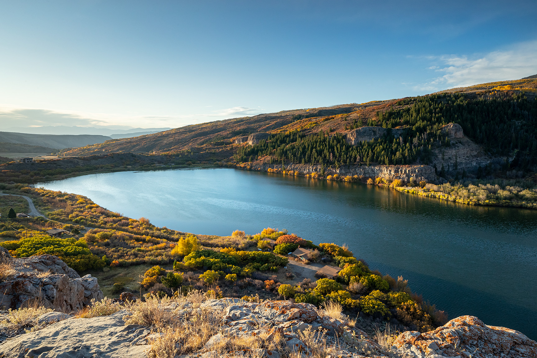
Pitkin County has approved funding for a study that aims to protect recreational flows in the Roaring Fork and Crystal rivers, and how future water development projects and climate change might affect those flows.

At a meeting earlier this month, Pitkin County commissioners approved a recommendation from the county’s Healthy Rivers Board to fund the $19,355 proposal from American Whitewater. The project includes an extensive survey of river users — specifically boaters — about what flows are optimal for certain popular river segments.

Kayakers, commercial river outfitters, stand-up paddleboarders and anyone else who runs local rivers can weigh in with their flow preferences for popular reaches of the Roaring Fork like North Star, Slaughterhouse, Toothache and the river below Basalt. They will also ask about the Crystal River, which gets less recreational traffic than the Roaring Fork, but has some well-known stretches, like the Narrows and Meatgrinder, which are favored by experienced kayakers, and the more accessible reach from Avalanche Creek to the BRB campground.

The lower Roaring Fork is increasingly popular with anglers, but this survey will focus on boating, both commercial and private.

Once American Whitewater determines what flows boaters prefer, the organization will use its “boatable days” tool, which compares the flow preferences to the historic river hydrology to see if and when the flow preferences are met and how that might change in dry or wet years.

“It allows us to actually quantify river recreation opportunities so it can be used to inform water management decisions and understand future impacts,” said Kestrel Kunz, Southern Rockies stewardship assistant for American Whitewater. “We can see how climate change might affect the number of boatable days in the valley.”

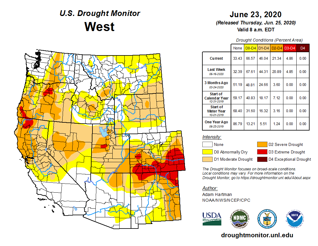
According to a report by the Colorado River Outfitters Association, the economic impact of commercial boating on the Roaring Fork in 2019 was $4.8 million. The economic impact statewide was $188 million. But despite the size of its contribution to the economy, recreation is an area often overlooked by traditional water planning and management, according to Pitkin County Healthy Rivers Board Chair Andre Wille.

“Recreation seems to really get the short end of the stick when it comes to streamflow management,” Wille said. “I think water managers in the Roaring Fork area and in a lot of other Western Slope rivers, the water managers are all about irrigation and recreation isn’t really taken into as much consideration as it should be, especially considering the economic impact of recreation and the importance to the citizens.”

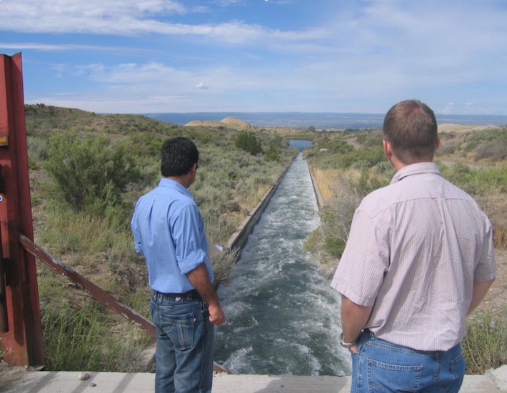
About 40% of the headwaters of the Roaring Fork and Fryingpan rivers is sent to Front Range fields and cities — including Aurora, Colorado Springs and Pueblo — through transmountain diversions. When the Twin Lakes tunnel underneath Independence Pass ratchets its intake up or down, it can affect boating conditions downstream on the Roaring Fork and diversions out of the Fryingpan can affect flows on the lower Roaring Fork.

The information collected in the survey could help water managers better plan when and how much water to divert.

“It’s just a chance to get some data from recreation users and it would be nice if water managers would take that into consideration,” Wille said. “There might be other stream management strategies that are beneficial to the Roaring Fork. There might be a better way to manage filling (Twin Lakes) reservoir.”

The survey, which will be available on the American Whitewater and Pitkin County Healthy Rivers websites and local paddling forums, will ask boaters about their skill level, frequency of participation and craft type. The survey will allow boaters to assign use-acceptability ratings to various streamflows and ask them for their perspectives on water management planning. American Whitewater aims to collect at least 150 surveys each from boaters on the Roaring Fork and Crystal rivers.

James Foerster, owner of Aspen-based rafting company Elk Mountain Adventures, said he’s excited to see the county focusing on recreational boating. The company is one of three, along with Blazing Adventures and Aspen Whitewater that run trips on the Roaring Fork.

Foerster’s company runs what they call “adventurous” rafting trips from Cemetery Lane to Jaffee Park in Woody Creek on the Slaughterhouse section of the Fork, as well as “family-friendly trips” from Jaffee Park to Wingo Junction above Basalt on the Toothache section and from Hooks Spur Bridge, near the Fed Ex outlet by Willits, down the river to the Catherine Store Road bridge above Carbondale.

He says guides will change the put-in and take-out locations to adapt to changing flows as the season goes on.

“I think every commercial outfitter would tell you more water is better,” Foerster said. “I think what it really comes down to is the flows we get coming through Aspen in late July and August, they are unsustainable. And the lower Crystal as well, mainly because of diversions and ditches.”

Carbondale-based Lotic Hydrological will develop the survey. The findings will be synthesized and presented as technical reports by December 2020.

Aspen Journalism is a local, nonprofit, investigative news organization covering water and rivers in collaboration with The Aspen Times and other Swift Communications newspapers. This story ran in the June 30 edition of The Aspen Times.

Map of the Roaring Fork River drainage basin in western Colorado, USA. Made using USGS data. By Shannon1 – Own work, CC BY-SA 4.0, https://commons.wikimedia.org/w/index.php?curid=69290878