Humpback chub are one of four federally endangered fish species that rely on habitat in the 15-Mile Reach of the Colorado River. Humpback chub photo credit US Fish and Wildlife Service.
Charismatic is hardly the best word to describe the humpback chub, a fish with a frowny eel face jammed onto a sportfish body in a way that suggests evolution has a sense of humor. Nor did tastiness build a fan base for this “trash fish” across its natural habitat throughout the Colorado River Basin. But, in 1973, the humpback chub became famous by winning federal protection under the Endangered Species Act.
Researchers in the Grand Canyon now spend weeks at a time, several times a year, monitoring humpback chub, which has become central to an ecosystem science program with implications for millions of westerners who rely on Colorado River water…
…the humpback chub’s experience is surprisingly meaningful now, as its river habitat deep in the iconic, redrock canyon becomes the subject of new scrutiny. New negotiations about the Colorado’s future begin later this year in a world that has fundamentally changed since foundational water agreements were drawn up, back when the river was flush and the entire basin was treated like a giant network of irrigation ditches.
Now, nearly a century after the original Colorado River Compact was forged, river stakeholders also find themselves in alien terrain as they try to reconcile an old management scheme with new realities, such as tribal rights, environmental protection and, especially, climate change.
‘The Pie is Getting Smaller.’
About 40 million people in seven states and Mexico rely on the Colorado for irrigation, drinking and even hydropower. Most of the water is used in agriculture to irrigate more than 5.5 million acres.
Meanwhile, the Colorado is shrinking. Average river flows have dropped 19 percent over the last century. About half of the decline is blamed on global warming, and scientists project that unchecked climate change could nearly triple flow reductions by the century’s end. Meanwhile, basin tribes want to tap into allocations they haven’t been able to use because they lack means to store and pipe the water.
NPS and USFWS use a seine net to trap humpback chubs in the Little Colorado River. Photo credit Mike Pillow via the Arizona Daily Sun.
And thanks to research mandated by the 1992 Grand Canyon Protection Act, the fate of the chub and the canyon ecology are factors that will also need to be considered in the yet-to-be-scheduled negotiations. Ultimately, everyone’s worried about losing their share of the Colorado River, of going home with partly empty buckets because there’s just not enough water to go around…
Water Rights: A Dramatic Struggle
The U.S. Interior Department must begin updating plans for managing the river, and convene all the states that rely on it, by the end of the year under the Colorado River Interim Guidelines, one of the agreements that determine how much water is allocated for each stakeholder to use or develop.
Like everything about Colorado River management, it’s legally complex and controlled by a deeply entrenched power structure involving the seven basin states, the federal Bureau of Reclamation and established users in agriculture and municipalities that have assigned positions in the line to the spigot—spots known as “water rights.”
[…]
But even the guidelines, which were implemented in 2007, have fallen short in the new, drier West. Last year, Congress approved a pair of Drought Contingency Plans, requiring varying levels of conservation to be implemented, state-by-state, whenever water levels sank too low at Lake Powell or Lake Mead, the ginormous storage reservoirs for Colorado River water. Both lakes dropped to emergency levels within months.
The original compact guarantees certain water volumes to the lower basin states—Arizona, Nevada and California. The upper basin states—Wyoming, Utah, Colorado and New Mexico—historically haven’t used all of their allocations but plan to develop theirs, too. For example, Utah is pressing forward with a multibillion-dollar project to pipe 86,000 acre feet halfway across the state to the fast-growing southwestern part of the state. A diversion of water from the Utah-Wyoming border to Colorado’s populous Front Range—killed and resurrected so many times it’s called the “zombie pipeline”—would use 55,000 acre feet.
Still, Schmidt said: “I am actually very hopeful. I believe that climate change and the real need to renegotiate agreements have brought us together.”
The role of global warming as a motivator for revisiting the water allocations probably can’t be overstated. The average temperature in the Southwest has already risen twice as fast as the global average and future temperatures are projected to increase as much as 9.5 degrees Fahrenheit by 2100.
Climate change is just one reason Daryl Vigil, water director for the Jicarilla Apache Nation and interim director of the Ten Tribes Partnership, is determined to see tribes at the table in the next round of negotiations. He says the 29 basin tribes have priority rights to about 20 percent of the Colorado River’s water but were snubbed by current users from past Colorado River talks.
Native American lands where tribes have water rights or potential water rights to Colorado River water. Graphic via Ten Tribes Partnership via Colorado Water Users Association website.
“The system is going to protect itself, to perpetuate what it already does because it benefits those who already are doing okay,” he said. “Familiar story, right?”
The exclusion, which amounts to environmental racism, means tens of thousands of indigenous people have not been able to access their water and tap into the associated economic opportunities, such as selling their water rights and using the water for energy projects, he said. Instead, other stakeholders are using tribal water without paying for it.
Another reason the tribes should be part of the decision making, he said, is because of their experience—thousands of years of dealing with water scarcity in the region—and their cultural views about the environment belong in any critical conversations about the Colorado. Otherwise the future looks “pretty catastrophic to us,” Vigil told High Country News this spring.
“When we start talking about climate change,” he said, “absolutely pushing to make sure that we’re thinking about a mindset of how we fit into Nature, rather than Nature fitting into us.”
[…]
[John] Fleck said the people deciding the basin’s fate need information about the tradeoffs. And data from Grand Canyon research will help them understand not only how to preserve a “sacred space” in American culture but also how to continue relying on a resource essential to the West.
A map prepared by Aurora Water that shows a potential 500-acre adjustment to the Holy Cross Wilderness boundary near the potential Whitney Reservoir on lower Homestake Creek. The map as current as of July 16, 2019.
Forty years after the Holy Cross Wilderness Area was created, an early effort to explore tapping its water supplies has generated more than 500 comments to the U.S. Forest Service.
Aurora and Colorado Springs, which own and operate the only reservoir in the area, Homestake I, hope to demonstrate that they can divert more water and build another reservoir to serve Front Range and West Slope interests without damaging the delicate wetlands and streams in the mountain forests there.
But first, they are asking the Forest Service for a special use permit to survey the area and to bore several test holes to determine soil conditions and areas best suited to build the proposed Whitney Reservoir. The public comment period closed June 30, although the Forest Service said it will continue to accept comments.
If a reservoir were to be built, it would also require that the 122,000-acre-plus wilderness area shrink by 500 acres, an action that will require congressional approval.
Significant opposition to the permit request is already building, with the Holy Cross Wilderness Defense Fund threatening legal action to stop the surveying and drilling of test holes into soils, according to comments submitted to the Forest Service.
Also opposing the process, among others, is Colorado state Sen. Kerry Donovan, who represents several West Slope counties. “Our wilderness areas are afforded the highest levels of protection and to begin action that disturbs them today begins a process of destroying them forever,” she said. [Editor’s note: Donovan is on the Board of Trustees of Water Education Colorado, which sponsors Fresh Water News].
In addition, she wrote, “With drought conditions becoming the new normal…it is imperative we protect high altitude water resources and keep each drop in the basin it was born in.”
The Eagle River is a tributary to the drought-stressed Colorado River, whose flows have already begun a serious decline.
Eagle River Basin
Jerry Mallet is president of Colorado Headwaters, an environmental advocacy group. The fight to stop the proposal, he said, “will be as big as the Two Forks fight was several years ago,” referring to the successful effort to stop Two Forks Reservoir from being built on the South Platte River in 1990.
Aurora and Colorado Springs point to their legal obligations to develop a project that serves multiple interests, and which also protects the environment, while ensuring their citizens have access to water in the future.
“The studies…will provide the factual data necessary to identify and evaluate feasible reservoir alternatives to provide critical water supplies for human and environmental purposes,” said Colorado Springs spokesperson Natalie Eckhart. “We recognize the necessity to partner with other agencies throughout this process and are committed to working collaboratively with other communities and agencies to best manage our shared water resources.”
The proposal comes under a 1998 agreement known as the Eagle River Memorandum of Understanding, which allows the reservoir proponents to develop enough water to serve environmental, municipal and industrial interests. Aurora and Colorado Springs hope to develop 33,000 acre-feet of water, an amount roughly equal to that used annually by 66,000 homes.
Under the proposal, Aurora and Colorado Springs would receive 20,000 acre-feet, West Slope interests would receive 10,000 acre-feet, and 3,000 acre-feet would be set aside for the Climax Molybdenum Company.
Parties to the 1998 agreement include Aurora, Colorado Springs, the Colorado River District, the Eagle River Water and Sanitation District, the Upper Eagle River Water and Sanitation District, as well as Vail Associates.
Diane Johnson, spokesperson for the two Eagle River districts, said the agencies haven’t yet taken a position on the proposal, citing the need for the analysis required for the special use permit as well as any actual construction of a reservoir to be completed.
Located west of Vail between Minturn and Leadville, the Holy Cross Wilderness Area was the subject of a significant battle in the 1980s when Aurora and Colorado Springs sought to build a second major reservoir there known as Homestake II.
After opponents successfully took their case all the way to the U.S. Supreme Court, Homestake II was defeated in 1994.
In exchange, however, the cities were granted permission to develop a smaller amount of water in the future in partnership with Western Slope interests, resulting in the project that is now being proposed to the Forest Service.
To submit your comments or to get more information about the survey and drilling proposal, visit this U.S. Forest Service’s web page.
Jerd Smith is editor of Fresh Water News. She can be reached at 720-398-6474, via email at jerd@wateredco.org or @jerd_smith.
A wetland area along Homestake Creek in an area that would be flooded by a potential Whitney Reservoir. The cities of Aurora and Colorado Springs are looking to develop additional water in Eagle County and divert it to the Front Range. Photo credit: Brent Gardner-Smith/Aspen Journalism
Click on a thumbnail graphic below to view a gallery of drought data from the US Drought Monitor.
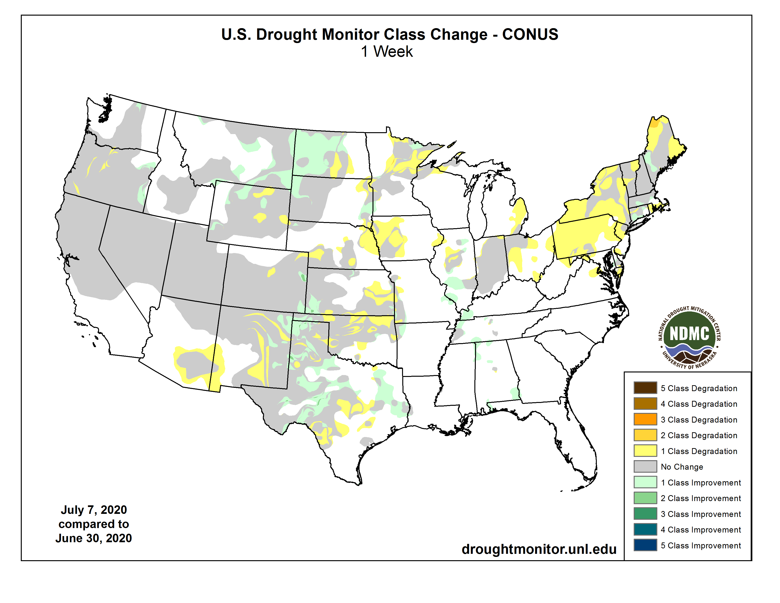
US Drought Monitor July 7, 2020.
West Drought Monitor July 7, 2020.
Colorado Drought Monitor July 7, 2020.
Click here to go to the US Drought Monitor website. Here’s an excerpt:
This Week’s Drought Summary
A trough of low pressure over the West kept much of the Northwest and Southwest unseasonably cool for early July, while high pressure, high humidity, and stalled or slow-moving fronts were the focus for scattered showers and thunderstorms across most of the Plains, middle and lower Mississippi and Tennessee River Valleys, the Southeast, and along eastern sections of the mid-Atlantic and New England. The greatest weekly totals (more than 2 inches) fell on the Dakotas, western parts of Illinois, Kentucky, and Tennessee, the lower Mississippi Valley, and along the eastern two-thirds of the Gulf and the southern Atlantic Coasts (including Florida). Light to moderate amounts (0.5-2 inches) were reported from western Washington eastward to western Minnesota, throughout most of the Plains and Southeast, and in eastern sections of the Northeast. Little or no precipitation fell on most of the Far West, Southwest, southern Texas, the Corn Belt, and western portions of the mid-Atlantic and New England. Temperatures averaged above normal east of the Rockies, especially in the Northern Great Plains, upper Midwest, and Great Lakes region that saw weekly departures of +4 to 10 degrees F. Temperatures averaged close to normal in the Southeast and lower Mississippi River Valley where frequent bouts of rain and clouds kept readings down. In Hawaii, windward shower activity increased later in the period, but was not enough to make any major improvements. Subnormal rainfall continued across Puerto Rico except in northwestern sections of the island, deteriorating conditions across eastern areas. In Alaska, light precipitation was measured at most stations, but a dry June around the Kenai Peninsula area warranted some D0 in southwestern Alaska…
A second week with widespread and abundant rains across much of the Dakotas and Montana, along with field reports on the rains impacts, justified large-scale 1-category improvements in western North Dakota (D1 to D0), northwest South Dakota (D1 to D0), southeastern Montana (D1 to D0), southwestern South Dakota (D0 to none), and parts of Montana (D0 to none). Field crops have responded, with both Dakotas reporting mainly fair to good conditions for corn, soybeans, barley, oats, winter and spring wheat, along with pasture and range conditions. Montana’s wheat and barley were also doing well. Farther south, scattered showers brought some relief to hard-hit sections of southwestern Kansas (D3 and D2) and southeastern Colorado, the latter area where the D4 area was eliminated after 0.5-2.5” of rain. In eastern Colorado, Kit Carson County received heavy rain, necessitating a D0 bubble on the map. However, where the rains were not as plentiful or were missed, dryness and drought expanded. This included D0 and D1 expansion in south-central North Dakota, northeastern and southeastern South Dakota, northeastern, south-central, and southwestern Nebraska, and southeastern Kansas. In Wyoming, a reassessment of conditions from field reports and indices included some reduction of D0 and D1 in western sections where it has been wet the past 30-days, but the addition of 3 small D2 areas in central and southeastern sections. The former lone D2 area in Wyoming was removed as indices did not support it…
Seasonably dry but unseasonably cool weather prevailed over much of the West, with mostly light precipitation (less than 1 inch) limited to the northern Cascades, northern Rockies, and eastern New Mexico. With precipitation normal generally low during July (except for the southwest monsoon which should be ramping up soon) and temperatures below-normal, most areas were status-quo except for the following exceptions. In north-central Washington, field conditions had improved enough to warrant a slight improvement of D2 to D1 in Okanogan County. The winter and spring wheat crops in southeastern Washington, northeastern Oregon, and west-central Idaho, known as the Palouse, should be excellent with cool temperatures and adequate rains for a longer time than normal. In Oregon, some slight deterioration was made in the southwestern and north-central areas (D2 and D3 expansion), but continued wetness in the east called for some slight improvement of D1 and D0 areas. The slow and warm start to the southwest monsoon season in southeastern Arizona and southwestern New Mexico was depicted with an expansion of D0 there. In eastern New Mexico, although spotty light to moderate (0.5-2 inches) showers fell, most areas remained status-quo as longer-term conditions will need much more moisture for significant improvement. Only small areas in eastern New Mexico where the totals exceeded 2 inches were improved by 1-category. However, in central areas where the rains missed, D1 and D2 were expanded westward to reflect the continuing deterioration of ground and vegetation conditions…
Scattered showers and thunderstorms also dotted the South just like the Southeast, although some areas completely missed out on the rains. This included central and southern Texas, central Oklahoma, northern Louisiana, central and northeastern Arkansas, and western Tennessee. The rains were welcome in northern Texas and western Oklahoma Panhandles, but the spotty nature of the thunderstorms made for an interesting drought depiction. Overall, some 1-category improvements were made to both areas, but large swatches of D2-D3 remained. Removal of the D0 areas in western Tennessee, Mississippi, and northeastern Texas were made if enough precipitation fell (generally more than 1.5 inches), but kept if weekly amounts were less, or 2-3 month deficits were still too large. Where little or no precipitation fell, degradation occurred when 30-, 60-, or 90-day deficits were large enough. This included parts of south-central Texas and central and northeastern Oklahoma. Tulsa, OK, measured only 0.11” of rain in June, its driest June since local records began in 1893. Southern Texas was left status-quo as 2-3 month surpluses were large enough to stave off this week’s dryness and heat, but rain will be needed soon. According to the USDA/NASS, crop conditions are a mixed bag depending on which state and which part of that state the crop is grown. Soybean and/or corn conditions were rated fair to good in Texas, Tennessee, Louisiana, Arkansas, and Mississippi, cotton and winter wheat rated 36% and 28% poor or very poor in Texas, respectively. In contrast, Oklahoma only had 7% winter wheat in poor or very poor condition, but much of Texas and Oklahoma’s winter wheat crop was already harvested. Topsoil moisture as of July 5 was 64% short or very short in both Oklahoma and Texas, with much lower values in Southern states to the east…
Looking Ahead
During the next 5 days (July 9-13), WPC’s QPF keeps much of the western half of the U.S. bone dry, with relatively light amounts (less than an inch) forecast for the eastern half of the Nation. Exceptions to this are moderate totals (1-2 inches) in the central Great Plains, upper Midwest, and along the Eastern Seaboard from Florida northward into Maine, with eastern sections of North Carolina and New England receiving the greatest amounts. Above-normal 5-day temperatures are expected in the Southwest and Northeast, with near to slight above-normal readings forecast for the remainder of the lower 48 States except for subnormal values across extreme northern Rockies and Plains.
The Climate Prediction Center’s 6-10 day outlook (July 14-18) favors above-normal precipitation across the northern tier of the U.S., from Washington to Michigan, in south Florida, and northern Alaska. Odds for subnormal precipitation are likely in the Southwest and southern halves of the Rockies and Plains, then eastward to the Carolinas and mid-Atlantic, and northward into New England. Above-normal temperatures are favored (more than 70%) from New Mexico northeastward into the Great Lakes region and Northeast, with the rest of the eastern half of the Nation and southwestern Alaska expecting above-normal readings. In contrast, below-normal temperatures are probable in the Northwest, Intermountain West, and northern half of Alaska.
US Drought Monitor one week change map ending July 7, 2020.
And, just for grins, here’s a gallery of early July US Drought Monitor maps for the past few years. The drought in the SW U.S. really stands out.
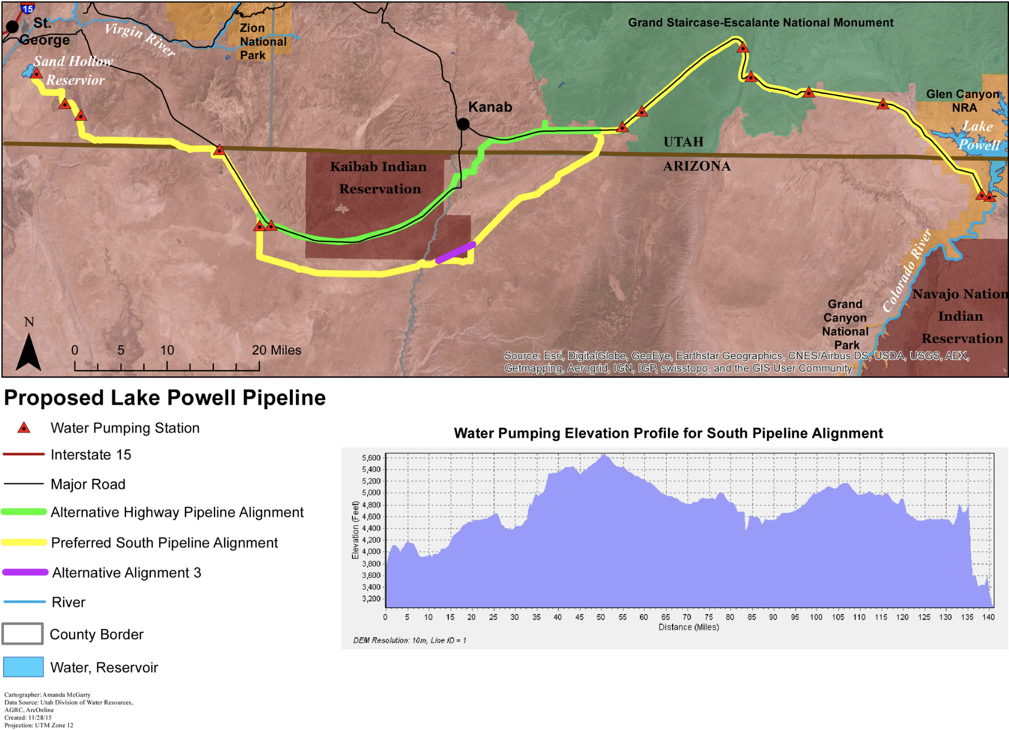
The public on Tuesday had its first opportunity to pepper officials with questions about the Lake Powell Pipeline’s recently-released draft environmental impact statement, a 313-page document from the Bureau of Reclamation examining how the controversial project could impact a myriad of resources in several scenarios.
That draft statement, which will be made final later this year after a period of public comment, looks at two proposed alignments of the approximately 140-mile pipeline that roughly straddles the Utah and Arizona borders.
It also weighs one option where no pipeline is built, and another where water in the Virgin River Basin — Washington County’s only source of water — is managed and stretched to support substantial population growth over the next several decades, possibly to the detriment of the river itself…
Among the questions posed by the approximately 130 participants who logged onto the meeting, held entirely online due to the COVID-19 pandemic, many centered on issues of climate change, the project’s impact on the already heavily-taxed Colorado River and how the pipeline would impact sensitive cultural and ecological sites along its 140-mile corridor…
One person asked Rick Baxter, Program Manager with the U.S. Bureau of Reclamation, if the agency considered “discouraging” the projected population growth driving the need for the pipeline.
Baxter, whose agency is impartial to whether the project gets approved or not, deferred that question to local and state policymakers.
Out of the two alignments of the pipeline being weighed, one, deemed the “Southern Alignment,” is favored by the bureau.
That alignment would begin near the Glen Canyon Dam on the west side of Lake Powell, cross in and out of Utah and Arizona, skirt around the southern edge of the Kaibab Paiute Indian Reservation and terminate at Sand Hollow Reservoir.
This $2+ billion project would pump 28 billion gallons of water 2,000 feet uphill across 140 miles of desert to provide just 160,000 residents in Southwest Utah with more water. Graphic credit: Utah Rivers Council
Its detour around the reservation means the Southern Alignment also has to pass through the Kanab Creek Area of Critical Environmental Concern, a unique and fragile habitat for the Southwestern Willow Flycatcher.
The Bureau of Land Management’s resource management plan for Kanab Creek currently does not allow for the pipeline to pass through there, so officials would need to amend that plan.
The other alignment roughly follows the Southern Alignment, but passes through the Kaibab Paiute Reservation and avoids the Kanab Creek protected area.
Baxter said the pros and cons of the two alignments are comparable; one doesn’t clearly stand above the other. But the reason the Southern Alignment is favored is because the project’s proponents haven’t been able to reach an agreement with the tribe.
Baxter was also pressed on why a “conservation alternative,” which would implement an aggressive conservation plan and develop local water resources, wasn’t considered.
The biggest reason a plan like that was passed over is it didn’t tap into a second water source outside the Virgin River Basin, which is one of the primary goals of the pipeline project — an effort to protect the water supply in the event something were to happen to one of the sources, Baxter explained.
“You can conserve your way to a certain point,” he said. “And even if you were to try to conserve your way to a certain point, at some point, if anything ever happened to that one source water managers would look for multiple different ways to protect the folks they’re providing water for.”