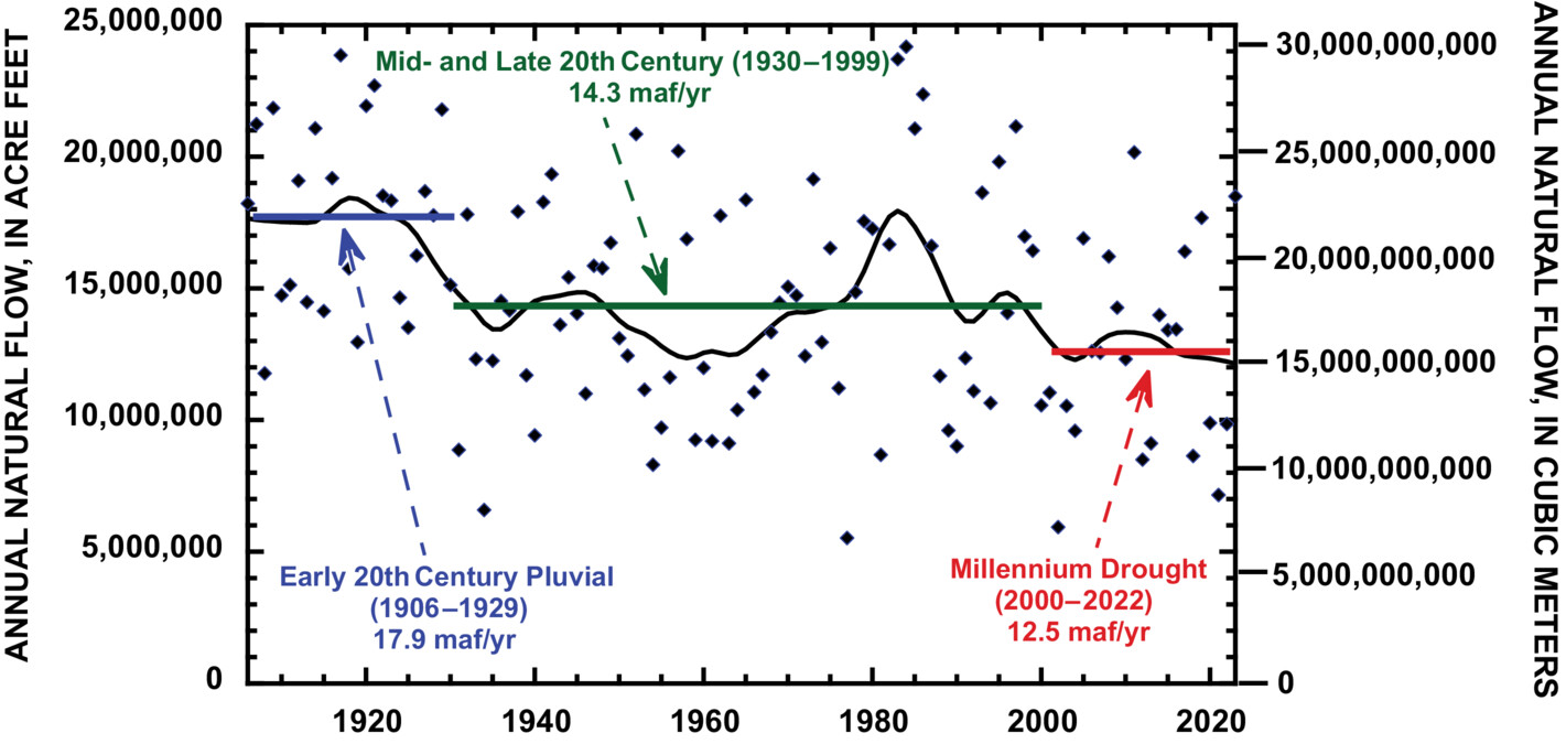
The graph above is from a study released a couple weeks ago, mid-June, on ‘The Colorado River Water Crisis: Its Origin and the Future,’ authored by two elders of Colorado River affairs: Dr. John Schmidt, river scientist at Utah State University, and Eric Kuhn, longtime manager of the Colorado River Water Conservation District.
During much of the 21st century, natural runoff in the Colorado River basin has declined, while consumption has remained relatively constant, leading to historically low reservoir storage. Between January 2000 and April 2023, the amount of water stored in Lake Mead and Lake Powell, the two largest reservoirs in the United States, declined by 33.5 million acre feet (41.3 billion cubic meters). As of April 2023, total basin-wide storage was sufficient to support the 21st century average rate of basin-wide consumption for only 15 months. Runoff in spring 2023 is predicted to be large, providing a short-term reprieve. However, it will take four to five additional unusually wet years in succession to refill Lake Powell and Lake Mead if basin-wide water use remains unchanged. Increasing evapotranspiration and dry soils associated with global climate change makes such a scenario unlikely. To stabilize reservoir storage, basin-wide use needs to equal modern runoff. To recover reservoir storage, basin-wide use needs to decline even more. Based on 21st century average runoff, a 13%–20% decline in basin-wide use would allow for stabilization and some reservoir storage recovery. Future policy debate about reservoir operations will inevitably concern whether most, or all, reservoir storage should be in Lake Mead or in Lake Powell. The choice of one or the other will result in significantly different environmental and recreational outcomes for Glen Canyon and the Grand Canyon.
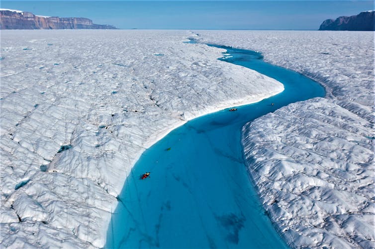
Richard Bates and Alun Hubbard kayak a meltwater stream on Greenland’s Petermann Glacier, towing an ice radar that reveals it’s riddled with fractures. Nick Cobbing.
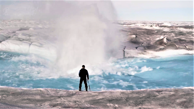
I’m striding along the steep bank of a raging white-water torrent, and even though the canyon is only about the width of a highway, the river’s flow is greater than that of London’s Thames. The deafening roar and rumble of the cascading water is incredible – a humbling reminder of the raw power of nature.
As I round a corner, I am awestruck at a completely surreal sight: A gaping fissure has opened in the riverbed, and it is swallowing the water in a massive whirlpool, sending up huge spumes of spray. This might sound like a computer-generated scene from a blockbuster action movie – but it’s real.
Alun Hubbard stands beside a moulin forming in a meltwater stream on the Greenland ice sheet. Courtesy of Alun Hubbard
A moulin is forming right in front of me on the Greenland ice sheet. Only this really shouldn’t be happening here – current scientific understanding doesn’t accommodate this reality.
As a glaciologist, I’ve spent 35 years investigating how meltwater affects the flow and stability of glaciers and ice sheets.
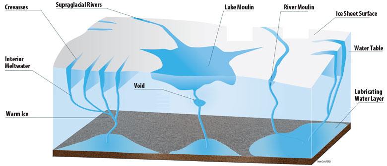
When it reaches the bed, the meltwater decants into the ice sheet’s subglacial drainage system – much like an urban stormwater network, though one that is constantly evolving and backing up. It carries the meltwater to the ice margins and ultimately ends up in the ocean, with major consequences for the thermodynamics and flow of the overlying ice sheet.
Scenes like this and new research into the ice sheet’s mechanics are challenging traditional thinking about what happens inside and under ice sheets, where observations are extremely challenging yet have stark implications. They suggest that Earth’s remaining ice sheets in Greenland and Antarctica are far more vulnerable to climate warming than models predict, and that the ice sheets may be destabilizing from inside. https://www.youtube.com/embed/stm1pBp0rfk?wmode=transparent&start=0 NASA’s GRACE satellites capture Greenland’s ice loss from 2002-2021.
This is a tragedy in the making for the half a billion people who populate vulnerable coastal regions, since the Greenland and Antarctic ice sheets are effectively giant frozen freshwater reservoirs locking up in excess of 65 meters (over 200 feet) of equivalent global sea level rise. Since the 1990s their mass loss has been accelerating, becoming both the primary contributor to and the wild card in future sea level rise.
How narrow cracks become gaping maws in ice
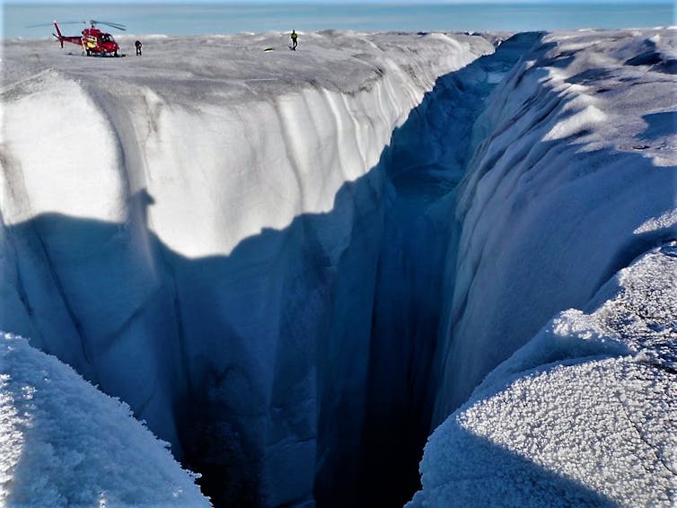
Moulins are near-vertical conduits that capture and funnel the meltwater runoff from the ice surface each summer. There are many thousands across Greenland, and they can grow to impressive sizes because of the thickness of the ice coupled with the exceptionally high surface melt rates experienced. These gaping chasms can be as large as tennis courts at the surface, with chambers hidden in the ice beneath that could swallow cathedrals.
But this new moulin I’ve witnessed is really far from any crevasse fields and melt lakes, where current scientific understanding dictates that they should form.
High rates of meltwater discharge combined with a thick and gently sloping ice sheet in Western Greenland gives rise to monster holes like this moulin. Alun Hubbard
In a new paper, Dave Chandler and I demonstrate that ice sheets are littered with millions of tiny hairline cracks that are forced open by the meltwater from the rivers and streams that intercept them.
Because glacier ice is so brittle at the surface, such cracks are ubiquitous across the melt zones of all glaciers, ice sheets and ice shelves. Yet because they are so tiny, they can’t be detected by satellite remote sensing.
Under most conditions, we find that stream-fed hydrofracture like this allows water to penetrate hundreds of meters down before freezing closed, without the crack’s necessarily penetrating to the bed to form a full-fledged moulin. But, even these partial-depth hydrofractures have considerable impact on ice sheet stability.
As the water pours in, it damages the ice sheet structure and releases its latent heat. The ice fabric warms and softens and, hence, flows and melts faster, just like warmed-up candle wax.
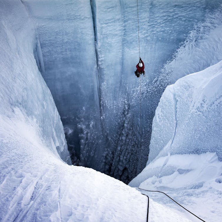
Alun Hubbard rappels into a moulin in October 2019, a point in the year when surface melt should have ceased but hadn’t. Lars Ostenfeld / Into the Ice
The stream-driven hydrofractures mechanically damage the ice and transfer heat into the guts of the ice sheet, destabilizing it from the inside. Ultimately, the internal fabric and structural integrity of ice sheets is becoming more vulnerable to climate warming.
The ice sheet is also flowing and calving icebergs much faster. It has lost about 270 billion metric tons of ice per year since 2002: over a centimeter and a half (half an inch) of global sea-level rise. Greenland is now, on average, contributing around 1 millimeter (0.04 inches) to the sea level budget annually.
Understanding the risks ahead is crucial. However, the current generation of ice sheet models used to assess how Greenland and Antarctica will respond to warming in the future don’t account for amplification processes that are being discovered. That means the models’ sea-level rise estimates, used to inform Intergovernmental Panel on Climate Change (IPCC) reports and policymakers worldwide, are conservative and lowballing the rates of global sea rise in a warming world.
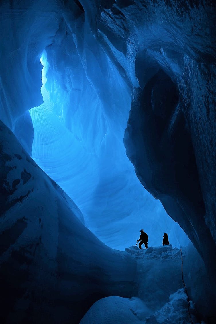
Daniela Barbieri and Alun Hubbard explore the contorted englacial plumbing deep inside a Greenland moulin. Lars Ostenfeld / Into the Ice
Our new finding is just the latest. Recent studies have shown that:
Superimposed ice slabs within the snowpack are forming across the accumulation zone, forming an impermeable barrier that depletes meltwater retention and drives extraordinary runoff.
In the last months, other papers also described previously unknown feedback processes underway beneath ice sheets that computer models currently can’t include. Often these processes happen at too fine a scale for models to pick up, or the model’s simplistic physics means the processes themselves can’t be captured.
Two such studies independently identify enhanced submarine melting at the grounding line in Greenland and Antarctica, where large outlet glaciers and ice streams drain into the sea and start to lift off their beds as floating ice shelves. These processes greatly accelerate ice sheet response to climate change and, in the case of Greenland, could potentially double future mass loss and its contribution to rising sea level.
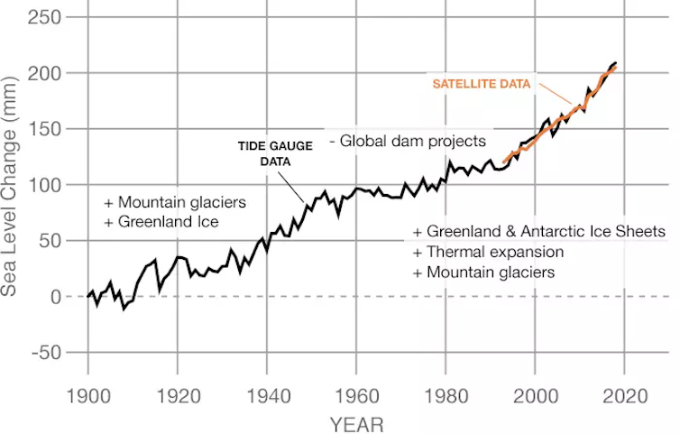
Greenland’s ice loss through meltwater and calving of glaciers has contributed nearly 10 centimeters (4 inches) to global sea-level rise since 1900. The chart shows sea level rise from all sources through 2018. NASA’s Goddard Space Flight Center/PO.DAAC
Current climate models lowball the risks
Along with other applied glaciologists, “structured expert judgment” and a few candid modelers, I contend that the current generation of ice sheet models used to inform the IPCC are not capturing the abrupt changes being observed in Greenland and Antarctica, or the risks that lie ahead.
Ice sheet models don’t include these emerging feedbacks and respond over millennia to strong-warming perturbations, leading to sluggish sea level forecasts that are lulling policymakers into a false sense of security. We’ve come a long way since the first IPCC reports in the early 1990s, which treated polar ice sheets as completely static entities, but we’re still short of capturing reality.
As a committed field scientist, I am keenly aware of how privileged I am to work in these sublime environments, where what I observe inspires and humbles. But it also fills me with foreboding for our low-lying coastal regions and what’s ahead for the 10% or so of the world’s population that lives in them.
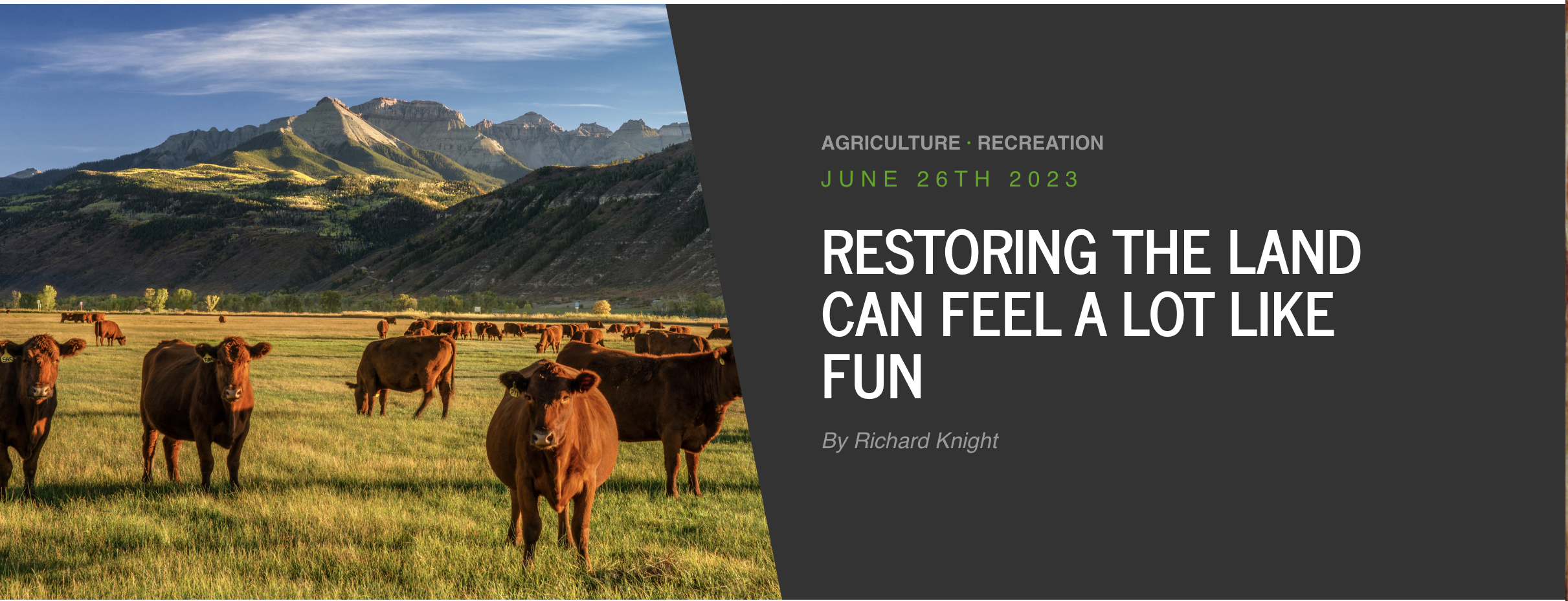
Driving back to Colorado State University with a van full of students after a day of working to heal some beat-up land north of Fort Collins, I wondered: Could ecological restoration be a new form of outdoor recreation?
We’d spent the day building a sawbuck fence around a spring. From the spring, gravity would carry the water through a pipe to a stock tank in the middle of the pasture.
On this land protected by a conservation easement, cows would no longer drink, pee and poop while trampling the spring’s vegetation. The spring could recover while the cattle drank clean water elsewhere.
My students had spent the day outdoors in the company of their classmates doing challenging physical work. At the moment, though, the young people were trying not to fall asleep as we neared town.
Yet all day I’d seen the light in their eyes, and I could tell they felt pride in learning and exercising skills they hadn’t had before. They also clearly liked the idea of giving something back to land that would never be developed.
This kind of volunteer work — The Nature Conservancy got us involved — addresses many problems today that we’ve come to call crises: species extinction, climate change, soil loss, and the decline of both water quantity and quality. Fortunately, many nonprofit groups, along with some owners of private lands that are protected by conservation easements, offer people an opportunity to improve damaged lands.
In my home watershed of northern Colorado, we often work with the nonprofit Wildlands Restoration Volunteers, a statewide grassroots group established in 1999. To date, it has completed over 1,000 projects on public lands assisted by more than 40,000 volunteers, who have contributed over $10 million in time and expertise.
Wildlands Restoration Volunteers includes people from both cities and rural areas who agree with what Wendell Berry wrote: “The care of the Earth is our most ancient and most worthy, and after all, our most pleasing responsibility. To cherish what remains of it and to foster its renewal is our only hope.”
At the end of the 20th century, scientists from around the world got together to measure our planet’s health. Shockingly, they reported that three out of every four acres of the Earth’s surface were in a degraded state.
The urgent global need to restore our damaged lands and waters has also caused the United Nations to name this the Decade of Ecosystem Restoration (https://www.decadeonrestoration.org/). It’s clear that we have yet to locate the sweet spot of a sustainable relationship with our world.
For humans to have a future on Earth, we need to reverse the erosion of soils, pollution of air and water, and weakening of the natural ecosystems that support us. Ecological restoration can attack those problems while also playing a critical role in the drawdown of atmospheric carbon dioxide, sending it back into the plants and soils where it belongs.
Although restoration and recreation have much in common, there is a major difference between the two. While outdoor recreation fulfills oneself, ecological restoration gives back to the land. Not that benefiting oneself is bad; one of the reasons we recreate is for the regenerative powers of spending time in nature.
But adding restoration into the domain of outdoor recreation could go a long way to enhance our time outdoors. I’ve found that when a group acts to restore the health of soil, land, plants and animals, the people involved always feel better about themselves.
Richard Knight
As author Robin Wall Kimmerer put it in “Braiding Sweetgrass,” “…as we care for the land, it can once again care for us.” By restoring damaged lands and waters, we still find joy in the outdoors, but we also give back to the home planet that sustains us.
Let’s seek out that work, turning it into something we do outdoors together, restoring lands and water while at the same re-creating ourselves.
Rick Knight is a contributor to Writers on the Range, writersontherange.org, an independent nonprofit dedicated to spurring lively conversation about the West. He is professor emeritus of wildlife conservation at Colorado State University.
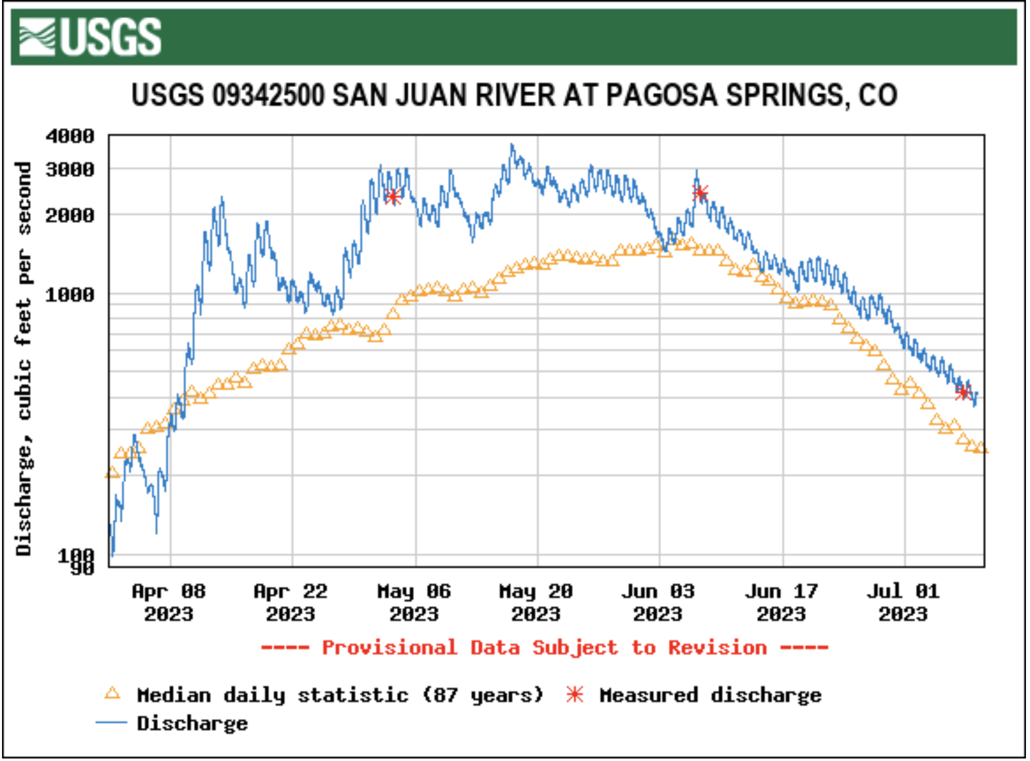
Flow levels in the San Juan River continued to drop this week, though they remain above median. The San Juan River in Pagosa Springs was running at 513 cubic feet per second (cfs) at 9 a.m. on July 5, down from a nighttime peak of 565 cfs at 3:15 a.m., according to data from the U.S. Geological Survey (USGS). The median flows for July 5, based on 87 years of data, are 301 cfs, according to the USGS. These flows are down from June 28 when, according to USGS, the river was flowing at 863 cfs at 9 a.m., down from a nighttime peak of 986 cfs at 1:15 a.m. The San Juan River has remained consistently above the median flow for the last 30 days, only briefly dipping below the median on June 4…
Drought Forecast
NIDIS…indicates that, over the next 90 days, most of the county will experience normal conditions with some areas seeing abnormally wet conditions and a small area seeing abnormally dry conditions.
Water Report
Pagosa Area Water and Sanitation District (PAWSD) District Engineer/Manager Justin Ramsey stated that most PAWSD reservoirs, including Lake Pagosa, Lake Forest, Lake Hatcher and Village Lake are full, but Stevens Lake is down about a foot. He added that there has not yet been a call on water in the Fourmile Creek drainage and that water is continuing to flow into Lake Hatcher.

