#Drought news November 20, 2025: some high-elevation areas of #Colorado and #Wyoming were 12 or more degrees above normal this week

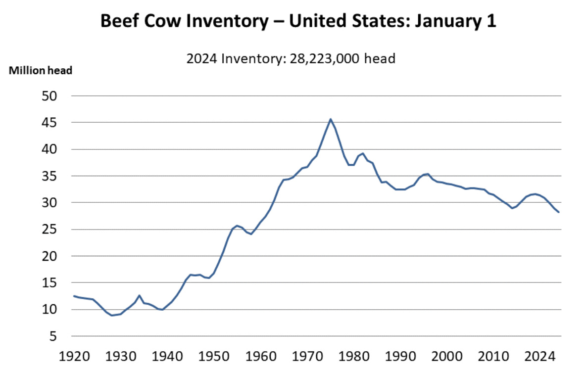
Click on a thumbnail graphic to view a gallery of drought data from the US Drought Monitor website.

Click the link to go to the US Drought Monitor website. Here’s an excerpt:

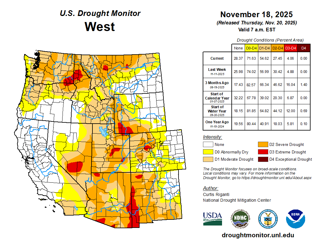
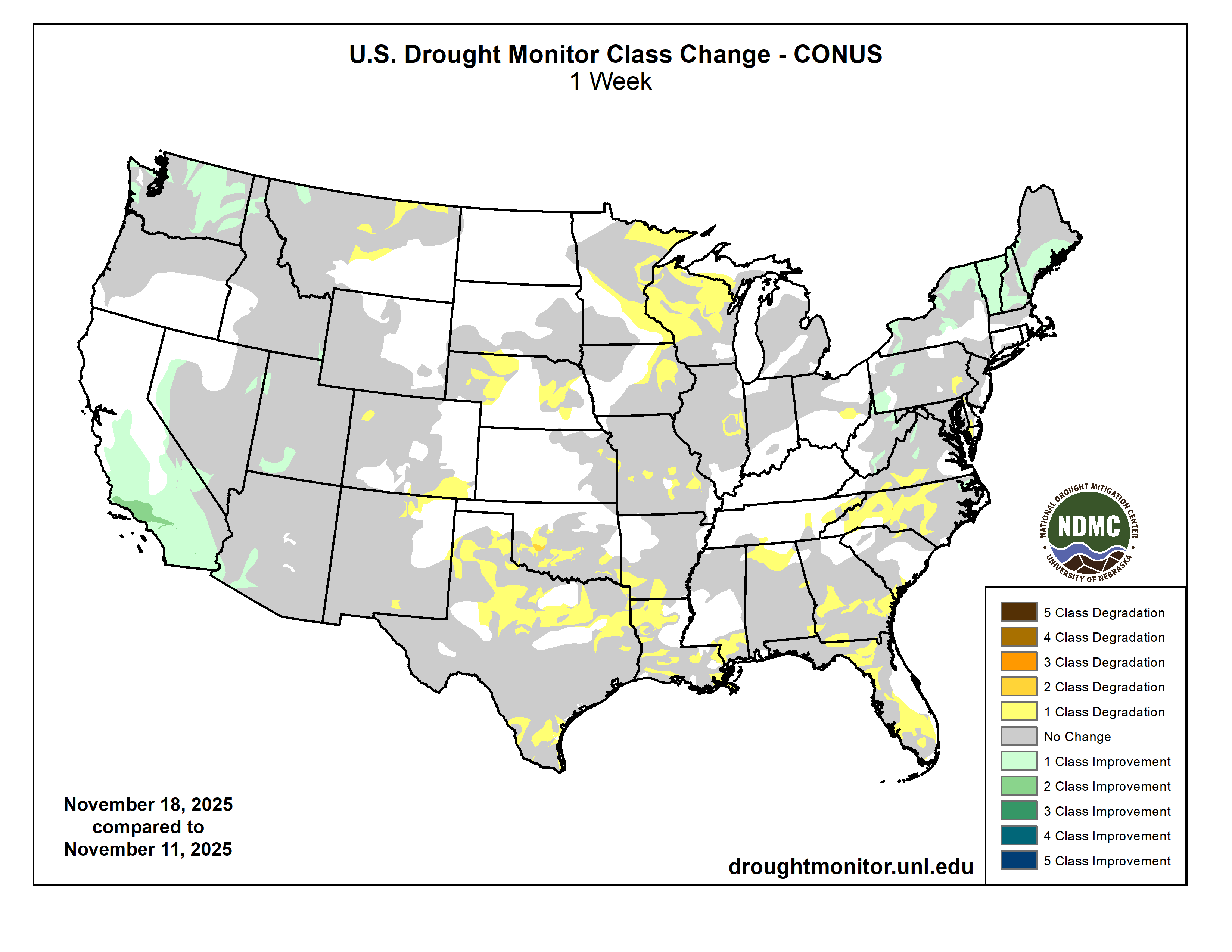
This Week’s Drought Summary

Dry weather covered most of the central and eastern U.S. this week, with a few localized areas of heavier precipitation falling in the Northeast and parts of eastern South Dakota. In the West, heavy rain and snow was widespread, especially in parts of southern Nevada, southern and coastal California, the Sierra Nevada, the Pacific Northwest and northwest Montana. Temperatures west of the Mississippi River were mostly warmer than normal, especially in Montana and Wyoming, where temperatures of 12 or more degrees above normal were common. East of the Mississippi River, near- or below-normal temperatures were widespread, especially in southern Georgia and Florida, where temperatures were 6-12 degrees colder than normal. Given the wetter weather recently, improvements continued in parts of the Northeast, where streamflow and soil moisture continued to recover and precipitation deficits lessened. Improvements were also widespread in California and Washington, where recent precipitation has cut into or erased precipitation deficits and boosted soil moisture and streamflow. Degradations were common in Oklahoma, Texas, Louisiana, Florida, Georgia and North Carolina, where short-term precipitation deficits grew. Widespread degradation also occurred in parts of Nebraska, central and northeast Montana and the western Great Lakes area, as primarily short-term dryness intensified in each of these areas. Recent pockets of drier- or wetter-than-normal weather led to a few small changes in areas of abnormal dryness in Puerto Rico. Wetter weather in the windward sides of Hawaii led to local improvements on Oahu, Maui and the Big Island, where streamflows have responded well to increased precipitation…

High Plains

Primarily dry and warmer-than-normal weather occurred in the High Plains region this week, with the exceptions of east-central South Dakota and some high-elevation areas of Colorado and Wyoming. Temperatures in Wyoming and parts of eastern Colorado were 12 or more degrees above normal this week, while eastern parts of the Dakotas, Nebraska and Kansas were mostly 3-9 degrees warmer than normal. Short-term precipitation deficits and decreasing soil moisture in some areas led to expansions and development of abnormal dryness and moderate drought in parts of eastern and central Nebraska. In western Nebraska, abnormal dryness and moderate drought expanded under similar conditions, while severe drought also developed where more substantial longer-term precipitation deficits were taking place. In and near the Kansas City area, moderate and severe drought locally expanded where soil moisture levels decreased and short-term precipitation shortfalls grew. Abnormal dryness expanded across the southeast Colorado plains where short-term precipitation deficits grew, while moderate drought filled in in northwest Colorado where short-term dryness aligned with long-term precipitation deficits…

Drought Monitor one week change map ending November 18, 2025.

West

Widespread heavy precipitation fell this week in California, southern Nevada, the Pacific Northwest and northern Idaho and northwest Montana. Locally over 5 inches of precipitation fell in northwest Washington, spots in northwest Montana and northern Idaho, and across scattered parts of California, especially in some coastal regions and the Sierra Nevada. Soil moisture levels increased across California amid the heavy precipitation. Precipitation deficits lessened in many areas or were entirely removed, leading to widespread 1-category improvements in California and localized 2-category improvements near Los Angeles. As the impact of this precipitation on the water cycle in California and Nevada is evaluated in the coming weeks, further improvements may occur. Conditions also improved after recent precipitation cut into precipitation deficits and locally improved soil moisture, groundwater and streamflow in northwest Washington, central and eastern Washington, northern Idaho and northwest Montana, southwest Arizona, and southwest Utah and along a portion of the Utah-Nevada border. Despite the widespread precipitation, weekly temperature anomalies were warm across the entire West this week. Compared to normal, Montana and Idaho were generally the warmest, with parts of Montana and southern Idaho finishing the week 12 degrees or more warmer than normal. In the plains of central and northeast Montana, moderate and severe drought and abnormal dryness quickly worsened amid warmer-than-normal temperatures and drier weather. In these areas, streamflow locally decreased amid growing soil moisture and short-term precipitation deficits…

South

Dry weather occurred across nearly the entire South region this week, which led to widespread degradations in conditions in some states. Warmer-than-normal temperatures occurred in parts of Texas and Oklahoma and some locales in Arkansas, while near- or below-normal temperatures were more common elsewhere. In the Texas Panhandle and southwest parts of the Lone Star State, temperatures of at least 9 degrees above normal were common. South of Oklahoma City, extreme drought developed where ponds dried up amid large short-term precipitation deficits and above-normal evaporative demand. Degradations occurred across large parts of southern Oklahoma where short-term precipitation deficits continued amid above-normal temperatures. A mix of short- and long-term precipitation deficits and warm temperatures led to degradations in southern Texas, while conditions also degraded in parts of north Texas and the Texas Panhandle during recent dry and warm weather. Short-term precipitation deficits also grew in much of northeast Texas, Louisiana, southwest Arkansas and southern Mississippi, leading to degrading conditions. Streamflow and soil moisture levels also were low in some areas that worsened this week…

Looking Ahead

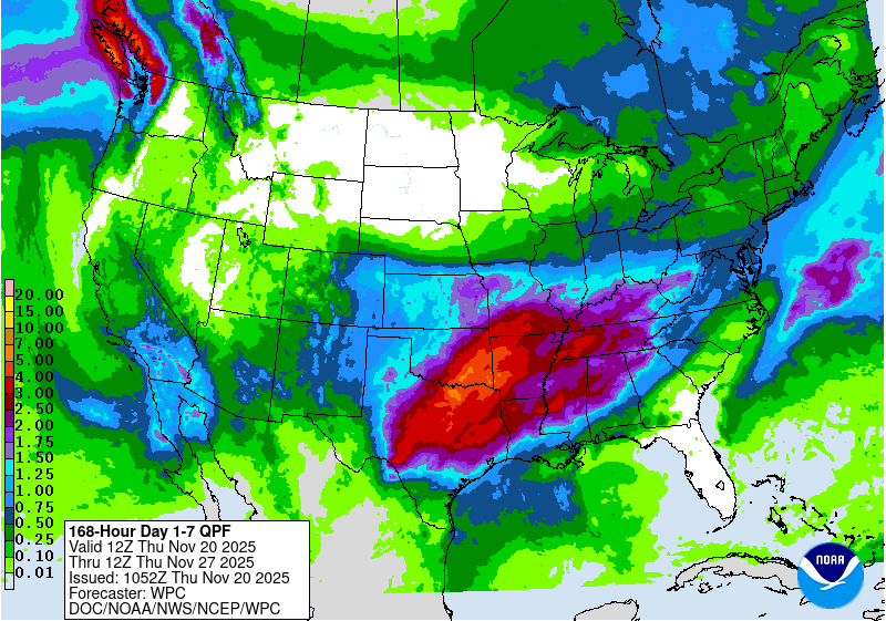
From the evening of Nov. 19 through Nov. 24, the National Weather Service Weather (NWS) Prediction Center is forecasting a large area to receive near or over 1 inch of precipitation from southern Ohio eastward to northeast Colorado and south to northwest Louisiana and much of Oklahoma and Texas (excluding the southwest). Precipitation amounts of at least 0.75 inches are also forecast in parts of southern California, southern Arizona and southeast two-thirds of New Mexico. Heavy precipitation, locally exceeding 3 inches, is forecast in parts of western Washington. Mostly dry weather is forecast across the northern Great Plains and from the Upper Midwest eastward to most of New York and northern New England. Dry weather is also likely to continue in much of the Southeast, especially in drought-stricken areas of southeast Louisiana, southern Georgia and Florida.

For Nov. 25-29, the NWS Climate Prediction Center forecast favors above-normal precipitation across parts of the northern, central and eastern U.S. The highest confidence areas for above-normal precipitation include the northern Great Plains and the Southeast. Drier-than-normal weather is favored in the Southwest U.S., especially in coastal California, southeast Arizona, southern New Mexico and southwest Texas. The forecast favors colder-than-normal temperatures from northern Washington east to Lake Superior and southward through the central Great Plains. In the West, warmer-than-normal temperatures are likelier from central Oregon southward along the Pacific Coast and eastward to near the Continental Divide. The forecast favors warmer-than-normal temperatures in areas from the Gulf Coast to the Mid-Atlantic, with the highest confidence for warmth centered over the Southeast.

In Hawaii, above-normal temperatures and precipitation are favored across the state. In Alaska, the forecast favors warmer-than-normal temperatures in central and western parts of the state, while southeast Alaska is more likely to be colder than normal. Above-normal precipitation is favored for the southwest part of Alaska, while the forecast leans towards below-normal precipitation in northern and southeast Alaska.

US Drought Monitor one week change map ending November 18, 2025.

USDA looks to expand public lands grazing: Plus: Data Center Watch, Mining Monitor, Messing with Maps 1940 edition — Jonathan P. Thompson (LandDesk.org)

Running cattle near Valley of the Gods in Bears Ears National Monument. Jonathan P. Thompson photo.

Click the link to read the article on The Land Desk website (Jonathan P. Thompson):

November 14, 2025

I promised a while back to take a closer look at the U.S. Department of Agriculture’s plan to ā€œFortify the American Beef Industry.ā€ I did, and my conclusion is that it’s a bunch of bunk. Okay, maybe not all of it: There are some parts about enforcing ā€œProduct of USAā€ labeling, and about supporting small processors by reducing overtime and holiday inspection fees and so forth that could be helpful to your friendly, local meat processor. 

Curiously, however, the plan’s main emphasis is on grazing on both Forest Service and Bureau of Land Management public lands, even though this makes up only a tiny portion of the U.S. beef industry. It’s almost as if the plan was driven by an ideological agenda rather than a practical one. Oh, and look at that: The Public Lands Council is taking credit for essentially formulating the grazing section of the plan! (h/t to Western Watersheds Project)

The plan will ā€œstreamline and expand grazing on federal lands, elevate grazing as an administration priority, and provide direct relief and support to American ranchers.ā€ The plan endeavors to return livestock to vacant grazing allotments and promises to ensure that the number of livestock grazing on public lands remains steady or increases. The plan also aims to diminish protections for wild predators — including endangered ones — and make it easier for ranchers to collect taxpayer subsidies when a wolf or bear is suspected of killing their cattle.

It’s difficult to imagine how public lands grazing can be made any easier. After all, the feds have charged a measly $1.35 per month for a cow-calf pair to graze on the public’s forage for years, which is the congressionally mandated minimum. And while the ā€œBureau of Livestock and Miningā€ might go back and forth on the ā€œminingā€ part of the monicker, it has retained its livestock-friendly reputation through every administration, Republican or Democratic. The agency regularly bends over backwards to accommodate livestock operations, and it often has been unable or unwilling to remove livestock from cattle-trampled lands to allow them to recover — even in ā€œprotectedā€ areas such as national monuments.

The administration is hoping to fill up the estimated 24 million acres of vacant grazing allotments and to bolster the number of cattle grazing on public lands, but it’s not clear how that would happen. It’s not like active allotments are bursting at the seams with too many cattle: In many cases, ranchers run far fewer cattle than authorized simply because they have fewer cattle to graze and because the industry is putting more cattle on feed. U.S. beef cattle inventories have declined by more than 30% since the 1970s (along with per capita consumption), but the number of beef cows in feedlots has ballooned.

Source: USDA National Agricultural Statistics Service.

Allotments may be vacant not because the BLM or Forest Service cancelled the lease, but because the forage is of marginal quality, due to drought or overgrazing or just not great grass growing conditions, or a conservation group bought out the lease from a willing seller. 

Even if the plan did increase the number of cattle on public lands, it wouldn’t make a big difference to the industry as a whole, because public lands provide less than 2% of all of the forage consumed by the nation’s 27.9 million head of beef cattle. 

Sending more cattle out into desert lands to eat what’s left of the native grasses and trample more sensitive places isn’t going to ā€œfortifyā€ the American beef industry. It will merely perpetuate the age-old and culturally embedded practice of giving grazing incredible leeway on public lands, while benefitting only a handful of chosen livestock operators.


The West’s Sacred Cow — Jonathan P. Thompson


I’m not an absolutist on the issue; I don’t believe thatĀ allĀ public lands grazing should be outlawed.Ā But it should be limited to appropriate places and at appropriate levels, and should be halted before it wrecks a particular landscape. Plus, ranchers should pay a reasonable amount for the thousands of pounds of taxpayers’ forage their cattle consume each month, along with a bit extra for the externalities, with which public lands grazing is rife. This sensible type of management simply is not occurring presently, as can be witnessed on just about any tract of active BLM ā€œrangelandā€ in the Four Corners Country, where fragile desert streambeds are being sullied and valuable cryptobiotic crusts decimated by herds of thousand-pound beasts.

Jonathan P. Thompson photo.

***

If the administration was really interested in helping these ranchers, it would support a ā€œjust transitionā€ away from public lands grazing, which is on the decline despite the government’s efforts to prop it up. That would include backing the Voluntary Grazing Permit Retirement Act, which was recently reintroduced in Congress by Rep. Adam Smith, a Washington Democrat.

The legislation would allow conservation groups to buy out federal grazing allotments from willing ranchers and livestock operators, after which the BLM or USFS would permanently retire the allotment. 

While private entities can and do buy out leases currently, there is no guarantee that the leases will remain cattle-free, which is what would allow the administration to re-cow some of those vacant leases mentioned above. The proposed legislation would fix that, making the retirement permanent. The resulting certainty would encourage conservation groups to invest more in the buyouts, which would benefit the ranchers, who may be looking to get out of the business or out of a specific grazing allotment.

A cow in the desert. Jonathan P. Thompson photo

šŸ¤– Data Center Watch šŸ‘¾

Certain aspects of the film Eddington just keep jumping off the screen into real life. The movie, if you haven’t seen it, is about a small town in southern New Mexico where a gargantuan tech firm, SolidGoldMagiKarp, has chosen to site a data center during the height of the COVID epidemic. There’s also a conflict between a mask-denying sheriff and a slightly more high-falutin’, charismatic mayor (who supports the data center and its purported economic benefits). A lot of drama ensues — most of it not directly related to the data center — which leads into a bloody, over-the-top machine-gun battle, which, it turns out, does have ties to the data center (which ultimately gets built, because: big money).

So far data centers haven’t provoked warfare of the kind in the movie. But they are spurring a lot of conflict in the desert over their potential water and power use. There’s Project Blue in southern Arizona, which promises to add enough electricity from renewable sources to Tucson Electric Power’s grid to offset its projected enormous power use, but a lack of specifics invites skepticism. Project Jupiter, the gargantuan data center campus planned for Santa Teresa, New Mexico, says it will generate its own power, but hasn’t specified how — except that it’s not likely to use nuclear reactors because they couldn’t come online quickly enough.

Now there’s another proposal, this one for New Mexico’s Permian Basin. New Era Energy & Digital wants to build a hyperscale, AI-processing data center complex in Lea County. It, too, will build dedicated generation: A whopping 2,000 megawatts of capacity from gas, and 5,000 MW from nuclear, according to a Power magazine report. That’s an insanely huge amount of electricity. Palo Verde nuclear plant near Phoenix has a nameplate capacity of 3,937 MW and Diablo Canyon in California has 2,236 MW of capacity.

Take a moment to digest that: This proposed data center would gobble up more electricity than two of the West’s largest power plants combined could generate, which is enough to power some 2 million homes. These numbers are terrifying, but they also strain belief and reinforce the suspicion that the AI-data center boom is actually just a hype-inflated bubble that’s poised to burst before most of these facilities are ever built. 

If New Era does advance its plan, it’s likely to encounter resistance (along with support) of the kind that could spark some cinematic conflict. A natural gas plant of that size could burn methane from oil wells that might otherwise have been flared off, but it will also emit carbon dioxide and other pollutants. And the nuclear reactors will produce radioactive waste, which likely would be stored onsite, something that even those accustomed to oilfield pollution might not be too enthusiastic about.

Meanwhile, the firm’s only disclosure about potential water use for cooling is that it chose the location in part for its ā€œabundant water supply,ā€ which is odd given the fact that theĀ Ogallala aquiferĀ on which the region depends isĀ being depleted rapidly. The only kind of water that’s abundant in those parts is produced water, the briny, contaminated liquid waste that comes up from oil wells at a rate of at least four barrels of water to each barrel of oil.


ā›ļø Mining Monitor ā›ļø

Anfield Resources went ahead and broke ground on its Velvet-Wood uranium mine in the Lisbon Valley in southeastern Utah last week, and claims it will be producing ore by the middle of next year. That’s despite the fact the firm has yet to submit its plans for a water treatment plant to state regulators. Also, the state has not approved Anfield’s proposed reopening of its Shootaring mill near Ticaboo, Utah, which is where the ore would be processed. Anfield officials told the Moab Times-Independent that they are unlikely to send ore to the White Mesa Mill near Blanding.

***

Atomic Minerals says it has received Bureau of Land Management approval to drill more exploratory holes at its Harts Point Uranium Project just outside Bears Ears National Monument and adjacent to the Indian Creek climbing area and the Needles District of Canyonlands National Park. The new drill holes will be just over two miles from the Dugout Ranch and Canyonlands Research Center.

***

The Trump administration has added 10 new minerals to the U.S. Geological Survey’s critical minerals list, including copper, potash, and uranium. This doesn’t automatically mean a whole lot, but it will potentially give federal and state agencies and regulators yet another reason to fast-track mining proposals.


šŸ—ŗļø Messing with Maps 🧭

One of the reasons I like looking at old maps and including them in these dispatches is that they provide a snapshot of how people, or at least the mapmakers, saw the region. Usually I put maps here that are at least a century old, simply because the changes they reveal are so dramatic. 

When someone posted this 1940 Rand McNally map of Utah on Facebook the other day, the most remarkable thing at first glance was that it included the proposed Escalante National Monument (which is why they posted it). But as I looked more closely, I realized that this map was made just as the West was about to go through a major transformation. Over the ensuing few decades the population of the region would explode as the post-war migration and uranium, coal mining, oil and gas, power plant building, and dam building booms swept across the West. 

Roads were built, small communities virtually vanished, and the landscapes and cultures were altered — along with the maps. These outtakes from the old map gives a glimpse of what the place was. For best viewing, click on the image and it will take you to the website. Click again and it should show you a larger version.

  • On the top outtake, notice the proposed Escalante National Monument, which would have stretched from Moab down to what is now Page, Arizona. By this time the proposal had been whittled downĀ from the original concept, which also would have included much of what is now Bears Ears and Grand Staircase-Escalante National Monuments and Canyonlands and Capitol Reef National Parks.Ā 
    Also note what is absent. The town of Page didn’t yet exist, because it was created to house workers building Glen Canyon Dam (construction began in 1956). Highway 95 followed a different route over Comb Ridge and ended at Natural Bridges NM. And the Moki Dugway road wouldn’t be built until the 1950s.
In western Colorado, especially, there were a lot of communities (probably very small, but big enough to include on a map) that no longer exist, including: Renaraye, McElmo, Ruin Canyon, Spargo, Ackmen, and Gladel. Ackmen basically relocated to Pleasant View after highway 666 (now 491) bypassed the older town; and Gladel is now Slick Rock. Egnar, meanwhile, does not appear on the map.

On the bottom map, note that I-15 didn’t yet exist, and the major artery through southwestern Utah, Hwy 91, bypassed the Virgin River Gorge south of St. George. I have to say, I really wish they hadn’t built an interstate through that lovely canyon. Also notable: Hildale, Utah/Colorado City, Arizona was simply Short Creek back then, and was on the Arizona side of the line (possibly where ā€œOld Colorado Cityā€ is now?).