Click the link to read the article on The Aspen Times website (Ryan Spencer). Here’s an excerpt:
April 11, 2026
An unprecedented March heatwave has forecasters shrinking already-low estimates for how much water will flow into the Colorado River during spring runoff, which is already well underway this year. The latest models show that the Colorado River is projected to deliver only about 1.4 million acre feet of water — roughly one-fifth of normal — to Lake Powell, the nation’s second-largest reservoir. Colorado River Basin Forecast Center hydrologist Cody Moser said during a water briefing on Tuesday, April 7, that if those projections were to bear out, it would be the third lowest amount of water delivered to Lake Powell in the reservoir’s 63 year history.
“We are on the extreme end of things,” Moser said. “We had a huge heatwave at the end of March with significant snowmelt.”
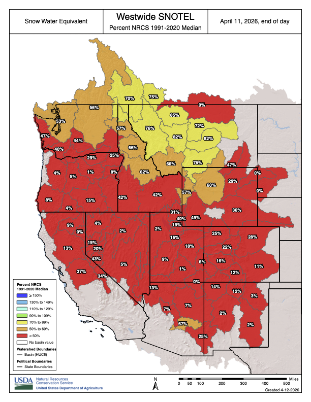
At the start of March, snowpack across the Colorado River Basin and projections for the spring runoff were already low, raising concerns of water shortages and an early start to what could be a dangerous fire season across the West. Then came a “very dry March” with a record-shattering heatwave that melted large amounts of the snowpack from the “most crucial areas for spring runoff,” Moser said. Nearly all of these areas had less than 50% of average precipitation in March, and have seen less than half of the average precipitation since October, he said.
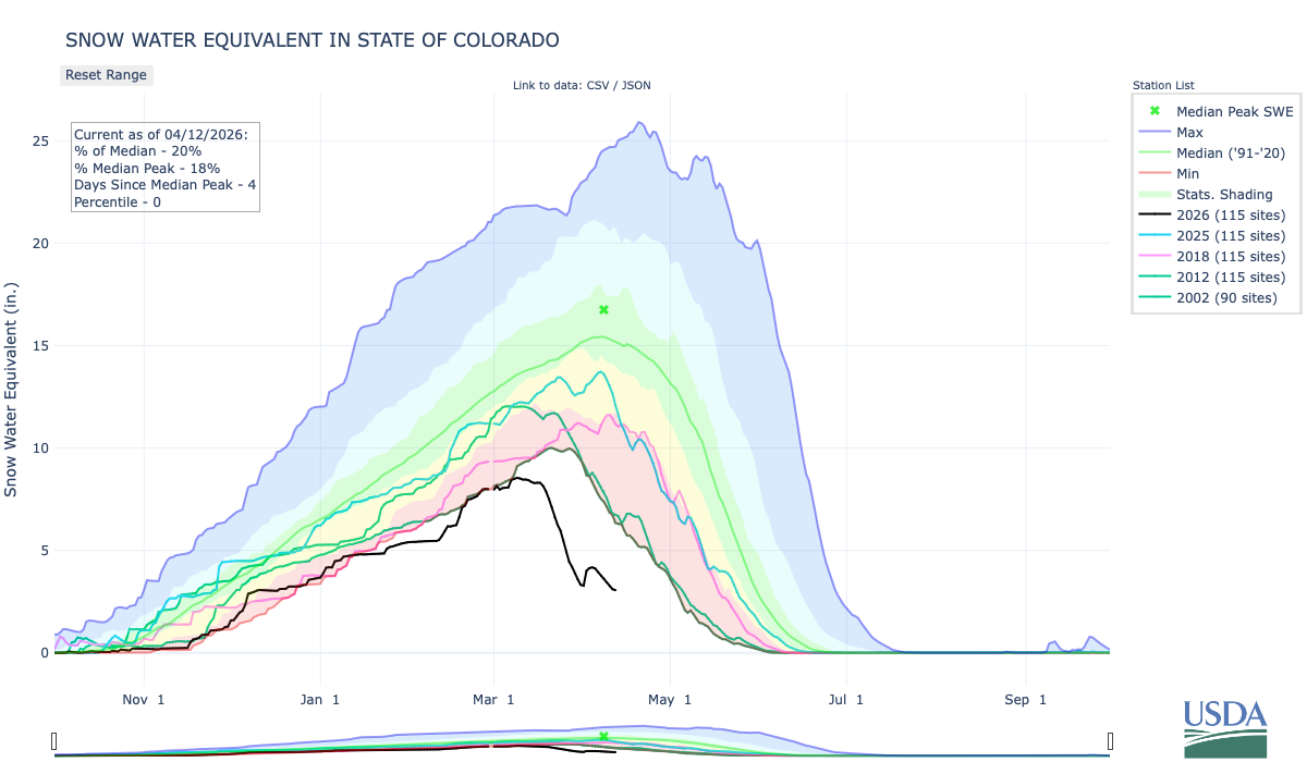
Averaged across Colorado, March was an “astonishing” 13 degrees Fahrenheit warmer than the 20th century average, almost 10 degrees warmer than the 1991-2020 average and more than 4 degrees warmer than any previous March, according to the state’s monthly climate summary. Large parts of the mountains experienced record-breaking temperatures lasting for days on end and leading to a rapid melt-off of the state’s already historically-low snowpack. Colorado started April with a snowpack that state climatologists said was the worst in at least the past 75 years. Colorado’s snowpack peaked in early March — a full month earlier than normal — at 8.5 inches of snow-water equivalent, or roughly half of the 30-year median, according to the state’s snow telemetry data. Normally, the state’s snowpack peaks on April 8, but by the time that date rolled around this year, the data show the statewide snowpack had declined to just 3.6 inches of snow water equivalent. That’s less than half what it was a month earlier, and just 23% of normal for that point in the season.