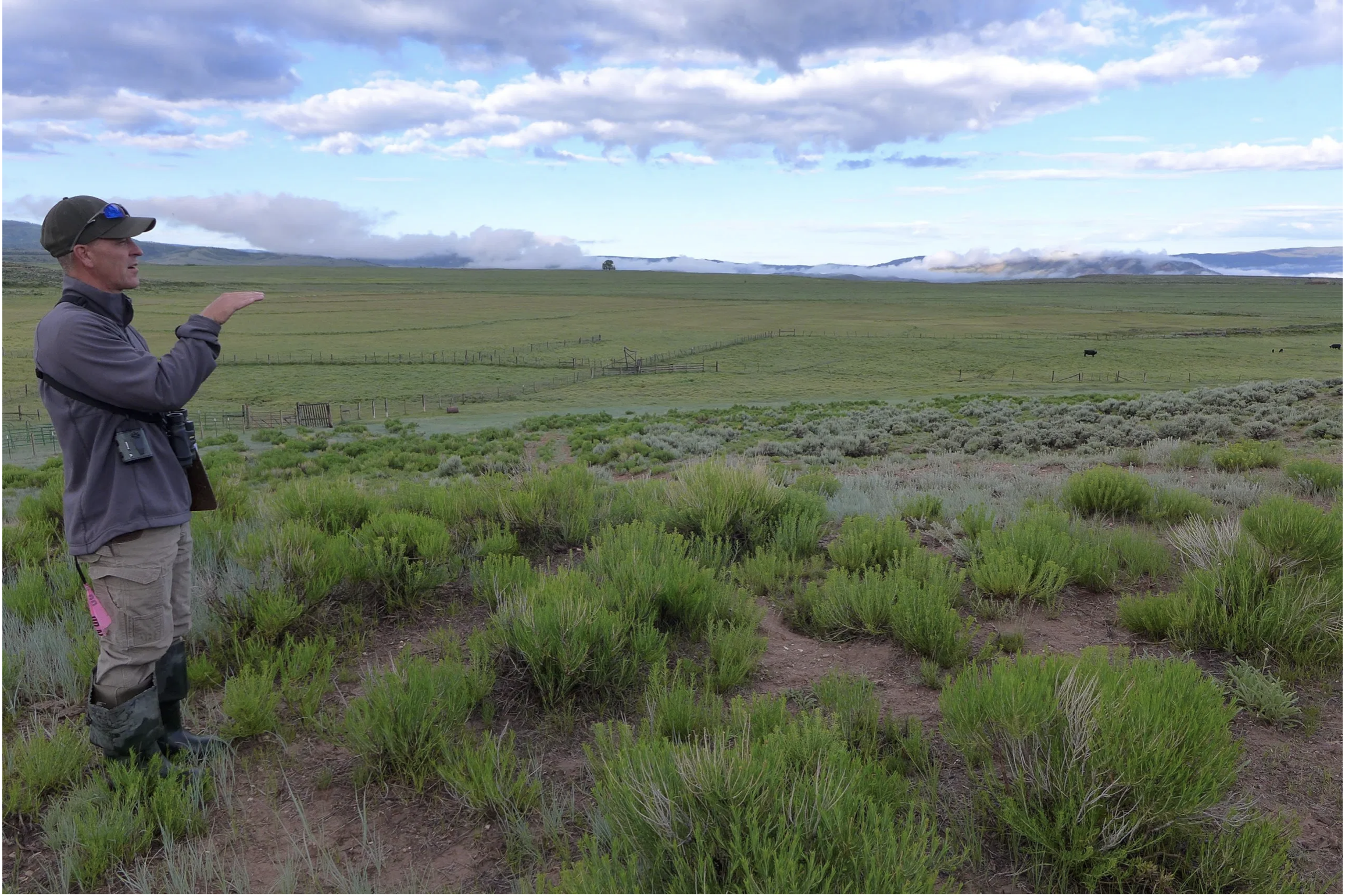
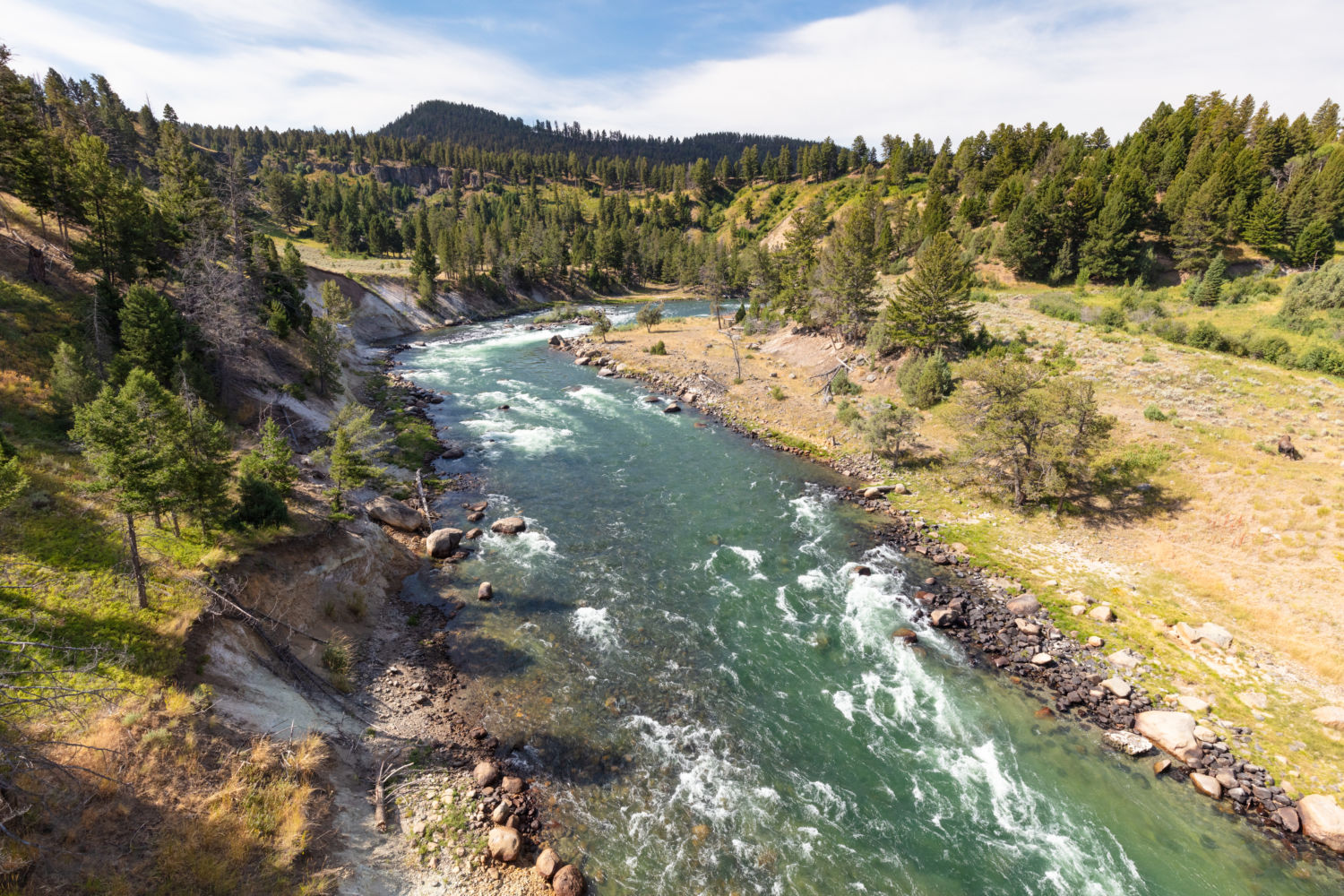
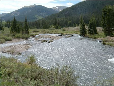
Wildlife biologist Bill Vetter watches and listens for birds in irrigated fields outside of Kremmling. Vetter is part of an avian monitoring program run by Audubon Rockies that aims to learn more about how birds use irrigated agriculture. CREDIT: HEATHER SACKETT/ASPEN JOURNALISM
In the gray light of dawn, hundreds of swallows darted over a pool of standing water in an irrigated field along the Colorado River. The birds were attracted to the early-morning mosquitos swarming the saturated landscape. Bill Vetter, a wildlife biologist with Wyoming-based Precision Wildlife Resources, methodically counted the birds. For six minutes, he marked down every bird he saw or heard at eight different locations across the ranch, 250 meters apart.
Vetter is part of an avian-monitoring program, headed up by Audubon Rockies, which aims to learn more about how birds use irrigated agricultural lands. In 2020, the fields near Kremmling where Vetter counted purposely did not irrigate as part of a state-grant-funded study on water use in high-elevation pastures. This year, irrigators are back to watering their usual amount and Vetter is tracking the trends in bird species and numbers.
This year, Vetter counted four or five additional species, including the yellow-headed blackbird, white-faced ibis and sora.
“I can say that for sure we got additional species this year that we didn’t have last year, and those species are largely associated with water habitat,” he said.
Across the Western Slope, birds and other wildlife have come to depend on these artificially created wetlands, a result of flood irrigation. But as the state of Colorado grapples with whether to implement a demand-management program, which would pay irrigators to temporarily dry up fields in an effort to send more water downstream, there could be unintended consequences for the animals that use irrigated agriculture for their habitat.
Learning more about how birds use these landscapes is a key first step, according to Abby Burk, Western rivers regional program manager with Audubon Rockies.
“Wetlands are the unsung hero for all the ecological services and functions they provide for wildlife,” she said. “Those low-field wetlands are good habitat for birds, for breeding, for migratory stopovers.”
In 2020, the bird count turned up 1,285 birds, comprising 39 different species, including great blue herons, meadowlarks, red-winged blackbirds, an osprey, a peregrine falcon, and several types of swallows, warblers and sparrows. The numbers are not yet tallied for this year, but the general expectation is that more water means more birds.
“Birds have adapted to how we have created these different habitat types,” Burk said. “We’ve really got to look at the larger effects of how we use water can impact birds and other wildlife. Where there’s water, birds also do thrive.”
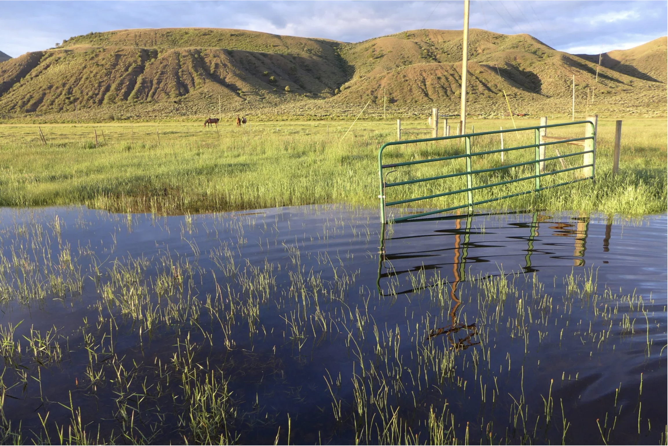
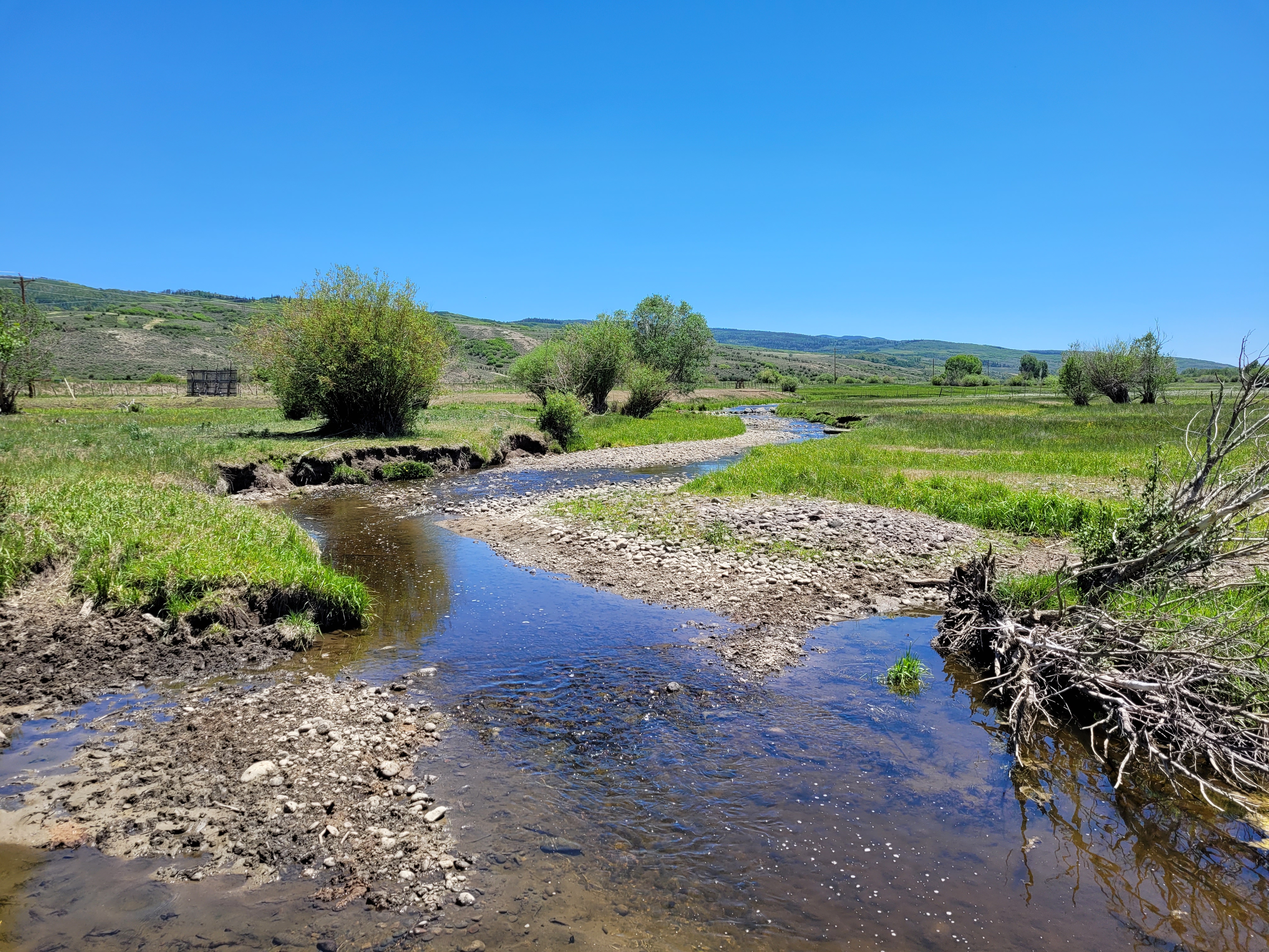
This pool of standing water in a field near the Colorado River is a result of flood irrigation. It’s also great habitat for mosquito-loving swallows. CREDIT: HEATHER SACKETT/ASPEN JOURNALISM
Water-use study
The seven ranches where the avian monitoring is taking place are part of a larger water study that is evaluating conserved consumptive use in the upper Colorado River basin. Consumptive use is a measure of how much water is consumed by thirsty plants. Conserved consumptive use is the amount by which consumptive use is reduced as a result of changing irrigation practices.
Researchers from Colorado State University are studying the impacts of using less water on the high-elevation fields in Grand County and how long it takes them to recover once water returns. Researchers hope to fill in a data gap about the impacts of reducing irrigation water on high-elevation pastures.
In 2020, some participating landowners did not irrigate at all and some only irrigated until June 15. This year, landowners reverted to their historical irrigation practices. Remote sensors and ground-based instruments are monitoring the difference in plant and soil conditions, and will continue to do so through 2023. Early results found that the plants used about 45% less water in 2020 compared with the previous four years.
The first phase of the project received a $500,000 grant from the Colorado Water Conservation Board (CWCB) under its Alternative Agriculture Water Transfer Method program, which aims to find alternatives to “buy and dry” water transfers. The CWCB in September will consider another $60,000 grant request for Trout Unlimited to continue to do monitoring with a field technician.
This monitoring station is part of a research project by Colorado State University to track soil and plant conditions in irrigated pastures. The study aims to learn more about how using less water affects high-elevation fields. CREDIT: HEATHER SACKETT/ASPEN JOURNALISM
Demand management
Although the project is not directly related to the state’s demand-management feasibility investigation, the results could have implications for any potential program that the state eventually comes up with.
“We are hoping all this information and research is going to be used down the road if a program does develop,” said Mely Whiting, Colorado water project legal counsel with Trout Unlimited. Trout Unlimited is helping to fund and implement the research project.
At the heart of a demand-management program is paying irrigators on a voluntary and temporary basis to not irrigate and to leave more water in the river in an effort to bolster levels in Lake Powell and help Colorado meet its downstream obligations.
Under the Colorado River Compact, the Upper Basin (Colorado, Wyoming, Utah and New Mexico) must send 7.5 million acre-feet each year to the Lower Basin (California, Arizona and Nevada). Failure to meet this obligation could trigger a “compact call” where junior water users in the Upper Basin would have their water cut off. (An acre-foot is enough water to cover one acre of land one foot deep.)
As rising temperatures due to climate change continue to rob the Colorado River and its tributaries of flows and increase the risk of a compact call, finding solutions to water shortages is becoming more urgent. Lake Powell, the river’s biggest reservoir, is just under 34% full and projected to decline further. Demand management would let the Upper Basin set aside up to 500,000 acre-feet in a special pool in Powell to help avoid a compact call.
Some still-unanswered questions remain: How much of the conserved consumptive water from high-elevation pastures would actually make it downstream to Lake Powell? And how much would local streams benefit from the added flows?
“One critical part of what we’re doing is looking at the stream and saying: Do we see any changes from one year to the next? How much water would actually make it to the stream?” Whiting said. “We are measuring to see if there’s any distinction between the year the conservation practices were applied and the following year.”
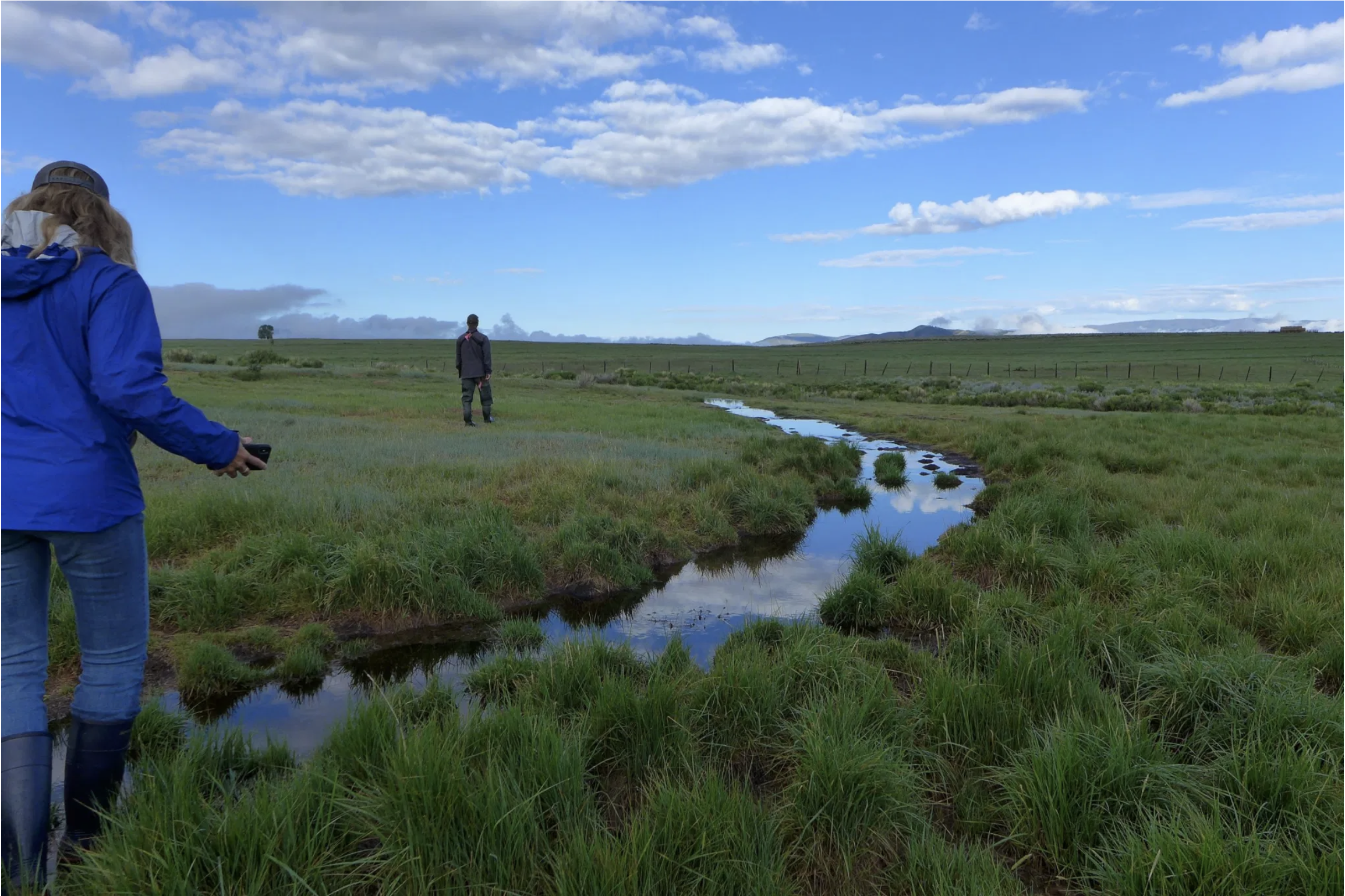
Wildlife biologist Bill Vetter and Western Rivers Regional Program Manager with Audubon Rockies Abby Burk walk along an irrigation ditch in Grand County. An avian monitoring program aims to learn more about how birds use irrigated agriculture. CREDIT: HEATHER SACKETT/ASPEN JOURNALISM
Trade-offs
The unintended consequences of different irrigation patterns under a demand-management program could be many and far-reaching. In 2018, the CWCB formed nine workgroups to examine some of these issues, including one that looked at environmental considerations.
In notes submitted to the CWCB last July, the environmental workgroup acknowledged there could be trade-offs, sometimes among species. For example, reducing irrigation and leaving more water in rivers would benefit fish and riparian habitats, but might negatively impact birds or other species that use wetlands created by flood irrigation. And with full irrigation, birds may thrive, but to the detriment of river ecosystems.
David Graf, water-resource specialist with Colorado Parks and Wildlife, participated in the environmental-considerations workgroup. He said irrigated agriculture provides a lot of diversity in forbes, grasses and insects — good sources of protein for birds. But fish need water too. And in the summer and fall, the more, the better. There is an environmental value in irrigated agriculture, but only if the streams aren’t suffering at its expense, Graf said.
“There is a whole bunch of wildlife that is dependent on irrigated agriculture,” he said. “I think we all recognize the value that irrigated agriculture brings to wildlife, but it’s at the expense of fisheries in a lot of cases. There’s a little bit of a trade-off on a local level. I think we get the balance wrong sometimes.”
This pool of standing water in a field near the Colorado River is a result of flood irrigation. It’s also great habitat for mosquito-loving swallows. CREDIT: HEATHER SACKETT/ASPEN JOURNALISM
Birds as indicator
Burk acknowledged that the usefulness of the bird count is limited by the absence of baseline data, because there was no bird monitoring on the fields before 2020. But trends are still important and, like the proverbial canary in the coal mine, birds can be an indicator of what’s happening on a landscape. Burk said she would like to do a bird-monitoring program on a larger scale at different locations around the Western Slope.
“As we learn more about how birds respond to water on the landscape, whether that’s in the river, in the fields, in the wetlands and adjacent habitats, it’s going to help give us a better picture of how the entire landscape and our natural systems are responding,” Burk said.
Colorado River water issues sometimes make for seemingly strange bedfellows. Nonprofit environmental groups such as Audubon are usually focused on keeping more water in the rivers, while irrigators traditionally take it out. In this case, interests align with keeping water on the landscape, with birds as the beneficiaries. Burk said those “us-versus-them” distinctions among water users are evaporating as people realize they are not facing the water crisis alone.
“When we drop the silos, drop the fences and walls between water users, we can see that this is one water — people, wildlife, the environment, the recreation industry — we all depend upon it,” Burk said. “So, how do we keep these natural systems so they can keep doing their job for everyone with reduced water? Water has to go further because there’s less of it.”
This story ran in The Aspen Times and the Craig Press on July 10.
On Wednesday, June 30, Gov. Jared Polis formally declared a drought emergency for 21 counties in the western portion of the state by proclamation.
The proclamation states that Colorado is now in phase 3 activa- tion of the State Drought Plan for 21 counties, including Archuleta, Hinsdale and La Plata counties.
Mineral County was not in- cluded in the governor’s proclamation.
However, a press release from the Colorado Water Conservation Board (CWCB) explains that counties along the Continental Divide in abnormally dry conditions or a moderate drought “will continue to be closely monitored and added to the drought emergency proclama- tion as appropriate.”
The CWCB press release explains that phase 3 is the highest level of activation under the State Drought Plan.
The CWCB press release notes that on June 22, 2020, phase 2 of the State Drought Plan was activated for 40 counties and expanded to all 64 counties by September 2020…
Colorado Drought Monitor map July 6, 2021.
Drought report
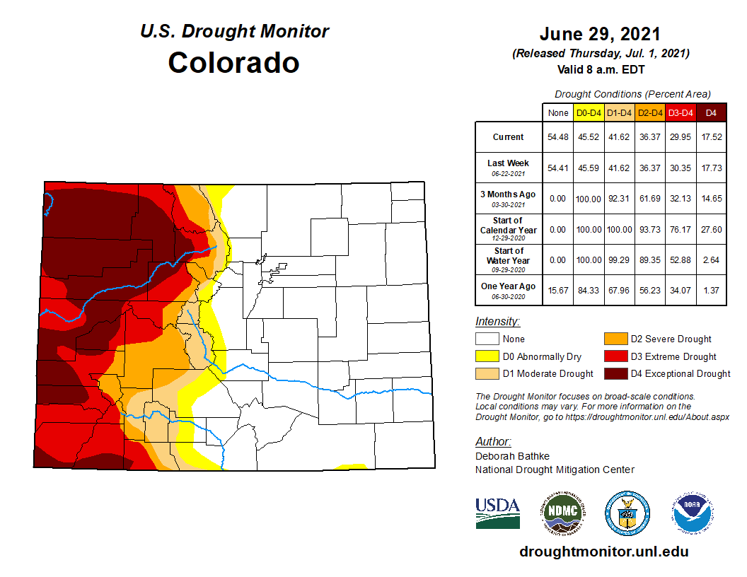
According to the National Integrated Drought Information System (NIDIS), as of 10 a.m. on June 29, 100 percent of Archuleta County remains in a moderate drought stage, with more than half of the county in extreme drought.
The NIDIS website notes that under a moderate drought stage, dry-land crops may suffer, rangeland growth is stunted, very little hay is available and risk of wildfires may increase.
The NIDIS website also notes that 71.17 percent of the county is in a severe drought stage.
According to the NIDIS, under a severe drought stage, fire season is extended.
Additionally, the NIDIS website notes that 51.04 percent of the county is in an extreme drought, mostly in the western portion of the county.
The NIDIS website notes that under an extreme drought stage, large fires may develop and pasture conditions worsen.
According to the NIDIS, 6.24 percent of the county, in the southwestern portion, is in an exceptional drought stage…
River report
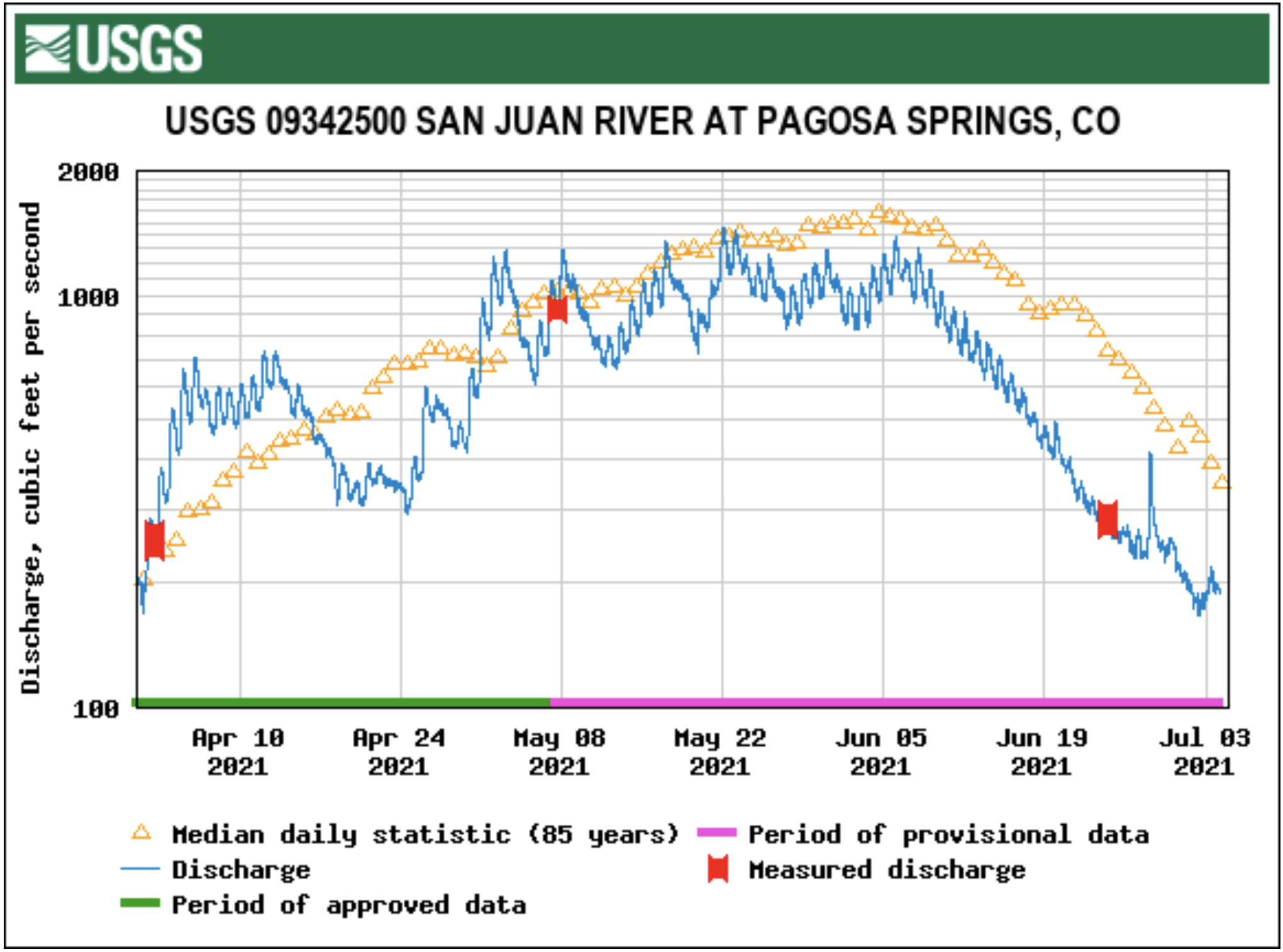
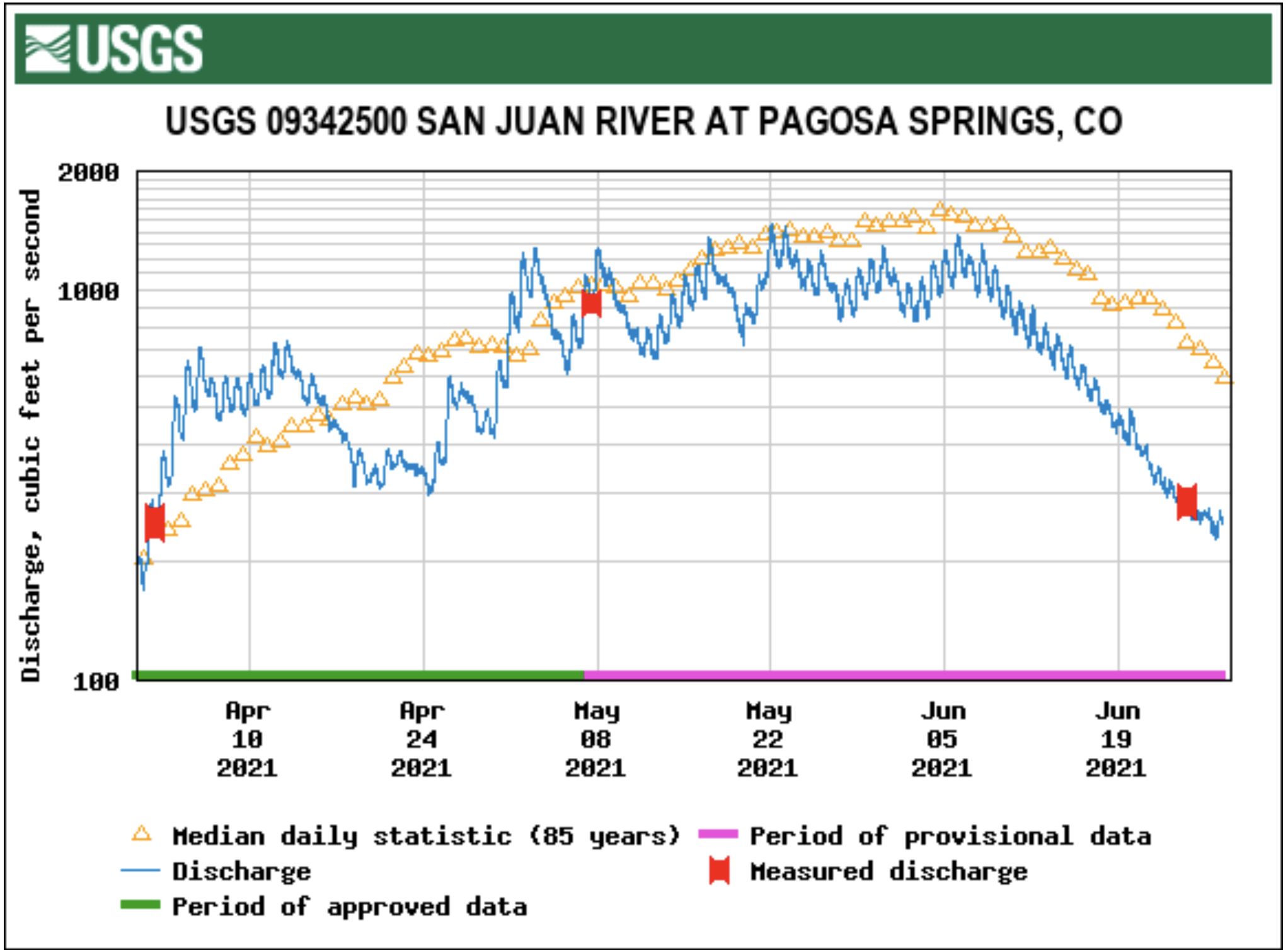
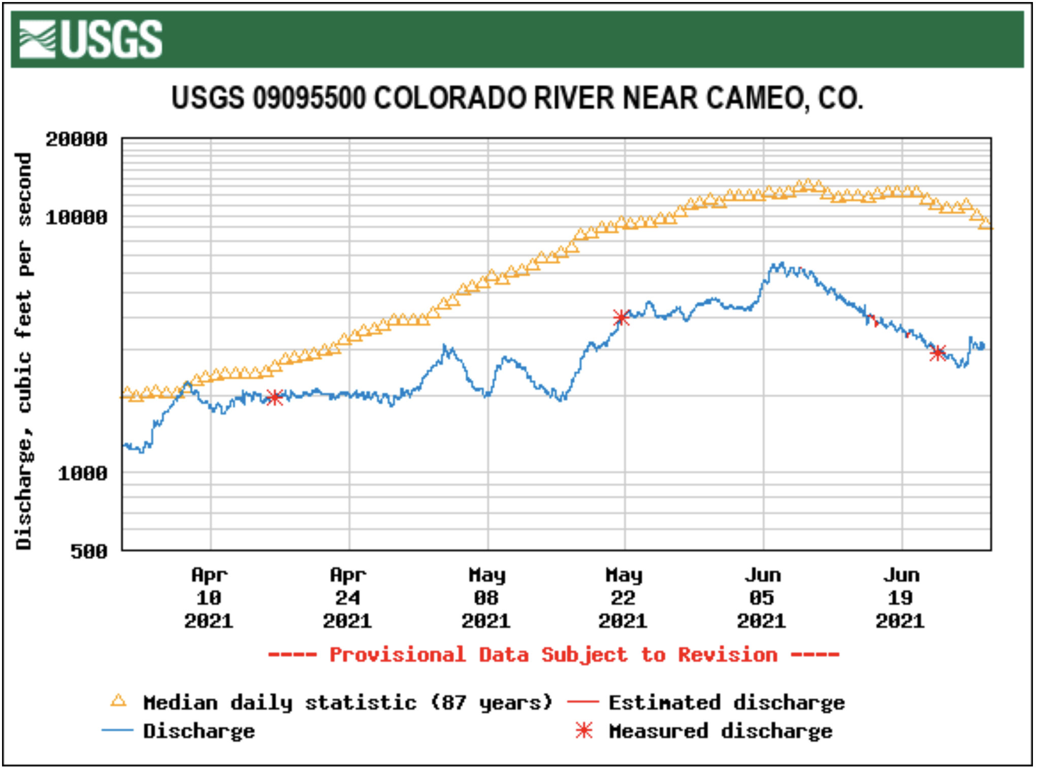
According to the U.S. Geological Survey (USGS), the San Juan River was flowing at a rate of 149 cfs in Pagosa Springs as of 10 a.m. on Wednesday, July 7.
Based on 85 years of water re- cords at this site, the average flow rate for this date is 482 cfs.
The highest recorded rate for this date was in 1995 at 2,080 cfs. The lowest recorded rate was 17.5 cfs, recorded in 2002.
As of 10 a.m. on Wednesday, July 7, the Piedra River near Arboles was flowing at a rate of 119 cfs.
Based on 58 years of water records at this site, the average flow rate for this date is 372 cfs.
The highest recorded rate for this date was 1,920 cfs in 1975. The lowest recorded rate was 8.05 cfs in 2002.
During a meeting on June 21, members of the San Juan Water Conservation District (SJWCD) board discussed local implications of historically low water levels in Lake Powell.
“The article that came out today just said that there’s a threshold that Lake Powell has to reach for the CWCB (Colorado Water Conservation Board) to enact some legal movements,” said board member Joe Tedder. “Apparently we’re going to hit that, probably by the end of June.”
The threshold Tedder referred to is outlined in the Colorado River Drought Contingency Management and Operations Plan (DCP).
The plan states that if Lake Powell reaches a surface elevation of 3,525 the upper-basin states and the U.S. Bureau of Reclamation (USBR) shall take action to send more water to Lake Powell from reservoirs upstream.
According to the USBR, the surface elevation of Lake Powell was 3,559 feet on July 4. Aside from the drought in 2005, such low water levels have not been seen since the 1960s, when Lake Powell was still filling after the construction of the Glen Canyon Dam was completed in 1963.
Low water levels in Lake Powell have implications for the Colorado River Basin, which includes the San Juan River and Pagosa Springs.
According to a report by the Pacific Institute in 2013, roughly 70 percent of the Colorado River Basin’s water is used to irrigate nearly 5.7 million acres of land for agriculture. The USBR estimates that more than 40 million people depend on the river to support their lives.
Another report prepared by Southwick Associates in 2012 esti- mated that 5.6 million people over the age of 18 use the Colorado River for recreational purposes each year.
The same report totals the value of all spending resulting from such recreational expenditures to be $25.6 billion, generating $1.6 billion in federal tax dollars…
SJWCD board member Doug Secrist outlined provisions in the DCP, stating that in an effort to stabilize Lake Powell, water would be reallocated from reservoirs up- stream, otherwise referred to as initial units…
“I can tell you that PAWSD is senior to all those reservoirs, so PAWSD water is pretty well protected,” SJWCD Board of Directors President Al Pfister said of the Pagosa Area Wa- ter and Sanitation District. “But it is a very intricate and interwoven issue.”
[…]
The National Integrated Drought Information System reports that Archuleta County is experiencing its driest year in over a century, and that the initial units from which water is planned to be supplied to Lake Powell are already low in volume and inflow…
The USBR predicts that the preliminary unregulated flow which supplies the Navajo Reservoir, which presently has a pool elevation 27 feet below the 1981-2010 average, will be 36 percent of the average for the month of July.
For Blue Mesa, which presently rests 43 feet below the 1981-2010 av- erage, is projected to have an inflow volume 40 percent of average.
Flaming Gorge, which rests only 3 feet below its average pool eleva- tion, is projected to have an unregu- lated inflow volume of 42 percent of average.
Gila River. Photo credit: Dennis O’Keefe via American Rivers
FromYale 360 (Jim Robbins). Click through for Ted Wood’s photo gallery:
The Gila was once a vibrant desert river, providing a lifeline for the riparian habitat and wildlife that depended on it in the U.S. Southwest. But population growth, agricultural withdrawals, and, increasingly, climate change have badly diminished the river and threaten its future.
The confluence of the tiny San Pedro River and the much larger Gila was once one of the richest locales in one of the most productive river ecosystems in the American Southwest, an incomparable oasis of biodiversity.
The rivers frequently flooded their banks, a life-giving pulse that created sprawling riverside cienegas, or fertile wetlands; braided and beaver-dammed channels; meandering oxbows; and bosques — riparian habitats with towering cottonwoods, mesquite and willows. This lush, wet Arizona landscape, combined with the searing heat of the Sonoran Desert, gave rise to a vast array of insects, fish and wildlife, including apex predators such as Mexican wolves, grizzly bears, jaguars and cougars, which prowled the river corridors.
The confluence now is a very different place, its richness long diminished. A massive mountain of orange- and dun-colored smelter tailings, left from the days of copper and lead processing and riddled with arsenic, towers where the two rivers meet. Water rarely flows there, with an occasional summer downpour delivering an ephemeral trickle.
On a recent visit, only a few brown, stagnant pools remained. In one, hundreds of small fish gasped for oxygen. An egret that had been feeding on the fish flew off. The plop of a bull frog, an invasive species, echoed in the hot, still air.
Gila River watershed. Graphic credit: Wikimedia
The Gila River, which was listed by the advocacy group American Rivers in 2019 as the nation’s most endangered river, drains an enormous watershed of 60,000 square miles. Stretches have long been depleted, largely because of crop irrigation and the water demands of large cities. Now, a warmer and drier climate is bearing down on ecosystems that have been deprived of water, fragmented, and otherwise altered, their natural resilience undone by human activities.
Other desert rivers around the globe — from the Nile to the Tigris and Euphrates to the Amu Darya in Central Asia — face similar threats. Efforts are underway to restore some integrity to these natural systems, but it is an uphill battle, in part because desert rivers are more fragile than rivers in cooler, wetter places.
Last year was the second-hottest and second-driest on record in Arizona, where heat records are frequently broken. The last two years have seen fewer desert downpours, known locally as monsoons, an important source of summer river flow.
“We’re dealing with a rapidly changing climate that is becoming, overall, more dry and varied and warmer,” said Scott Wilbor, an ecologist in Tucson who studies desert river ecosystems, including the San Pedro. “We are in uncharted territory.”
Born of snowmelt and springs in the mountains of southern New Mexico, the Gila is the southernmost snow-fed river in the United States. It was once perennial, running 649 miles until it emptied into the Colorado River. As the climate warms, scientists predict that by 2050 snow will no longer fall in the Black and Mogollon ranges that form the Gila’s headwaters, depriving the river of its major source of water.
“We’re seeing a combination of long-term climate change and really bad drought,” said David Gutzler, a professor emeritus of climatology at the University of New Mexico. If the drought is prolonged, he said, “that’s when we’ll see the river dry up.”
The Gila River as it nears the Florence Diversion Dam in Arizona was almost dry by May this year. Photo credit: TED WOOD via Yale 360.
The same scenario is playing out on the once-mighty Colorado, the Rio Grande, and many smaller Southwest rivers, all facing what is often called a megadrought. Some research indicates that a southwestern U.S. megadrought may last decades, while other scientists fear the region is threatened by a permanent aridification because of rising temperatures.
Worldwide, said Ian Harrison, a freshwater expert with Conservation International, “pretty much where there are rivers in arid areas, they are suffering through a combination of climate change and development.”
Like the Gila, many of these rivers have high degrees of endemism. “Life is often highly specialized to those particular conditions and only lives on that one river, so the impacts of loss are catastrophic,” he said.
Rivers everywhere are important for biodiversity, but especially so in the desert, where 90 percent of life is found within a mile of the river. Nearly half of North America’s 900 or so bird species use the Gila and its tributaries, including some that live nowhere else in the U.S., such as the common blackhawk and northern beardless tyrannulet. Two endangered birds, the southwestern willow flycatcher and yellow-billed cuckoo, live along the Gila and its tributaries, including the San Pedro and the Salt.
Desert rivers, of course, make life in the desert possible for people, too. Growing crops in the perpetual heat of the desert can be highly lucrative, especially if the water is free or nearly so thanks to subsidies from the federal government. Agriculture is where most of the water in the Gila goes.
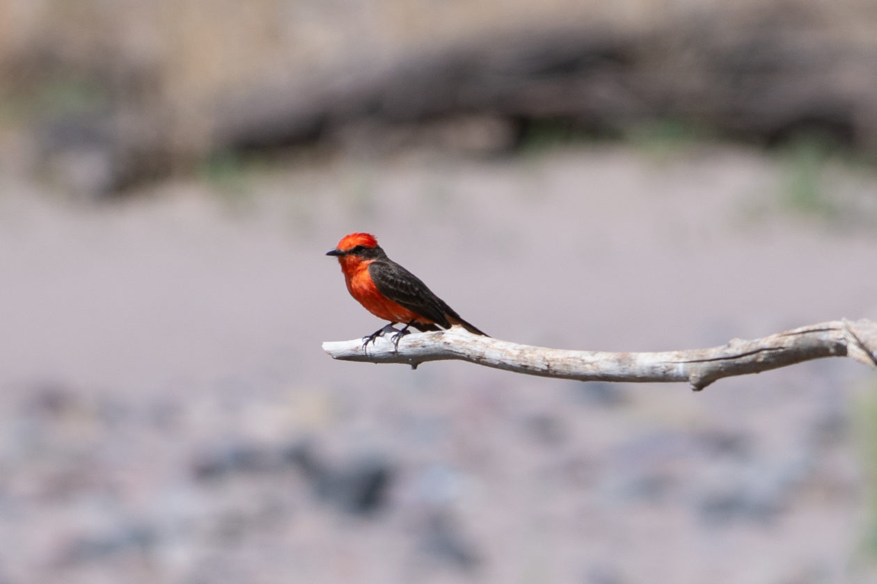
A vermillion flycatcher perched near the Gila River in Safford, Arizona. Photo credit: TED WOOD via Yale 360
This spring, photographer Ted Wood and I made a journey along the length of the Gila, from the headwaters in New Mexico to west of Phoenix. In most of Arizona, the Gila is dry. Where it still flows, I was impressed by how such a relatively small river, under the right conditions, can be so life-giving. The trip brought home what desert rivers are up against as the climate changes, and also how much restoration, and what types, can be expected to protect the biodiversity that remains.
Our journey began at the river’s source, where Cliff Dweller Creek spills out of a shady canyon lined with Gambel oak in Gila Cliff Dwellings National Monument. The creek is barely a trickle here. Above the creek, ancestral Puebloans, known as Mogollon, once lived in dwellings wedged into caves, making pottery and tending vegetable gardens. The Mogollon abandoned these canyons in the 15th century, perhaps done in by an extended drought.
From inside a Mogollon cave, I looked out at rolling hills, covered with ponderosa pine, pinyon and juniper trees. The green-hued water gains volume where three forks come together near here. Historically, the mountain snow melts slowly each spring, providing high steady flows through April and May. Flows slow to a trickle in June. In July and August, monsoons pass through and, along with frontal systems, cause flash flooding and a rise in water levels.
Flooding is a “disturbance regime,” not unlike a forest fire, that rejuvenates aging, static ecosystems. A healthy river in the mountains of the West is one that behaves like a fire hose, whipping back and forth in a broad channel over time, flash flooding and then receding, moving gravel, rocks, logs and other debris throughout the system. A flooding river constantly demolishes some sections of a river and builds others, creating new habitat — cleaning silt from gravel so fish can spawn, for instance, or flushing sediment from wetlands. A river that flows over its banks, recharges aquifers and moistens the soil so that the seedlings of cottonwoods, mesquite trees and other vegetation can reproduce. Along healthy stretches of the Gila, birds are everywhere; I spotted numerous bluebirds in the branches of emerald green cottonwoods.
Gila Cliff Dwellings National Monument New Mexico, an ancestral Puebloan ruin at the headwaters of the Gila River. Photo credit: TED WOOD via Yale 360
The riparian ecosystem that lines the 80 or so miles of the New Mexico portion is largely intact because of the protections afforded by federal wilderness areas, the lack of a dam, and the river’s flow not being completely siphoned off for farming. This is an anomaly in a state that has lost many of its riparian ecosystems. “This is the last free-flowing river in New Mexico,” said Allyson Siwik, executive director of the Gila Conservation Coalition.
The future of the New Mexico stretch of the river is uncertain because of the possibility of more water withdrawals and the loss of snowpack. “We’ve seen flows in the last 10 years lower than we’ve ever seen,” Siwik said. This year, she said, set an all-time low on the river, with flow less than 20 percent of normal.
Undammed, the Gila River through New Mexico still floods, refreshing the Cliff-Gila valley, which contains the largest intact bosque habitat in the Lower Colorado River Basin. The valley is home to the largest concentration of non-colonial breeding birds in North America. The river is also a stronghold for threatened and endangered species, such as nesting yellow-billed cuckoos, the Gila chub, Chiricahua leopard frogs and Mexican garter snakes all live there.
At odds with efforts to keep the Gila wild are plans by a group of roughly 200 long-time irrigators in southwestern New Mexico. Each summer they divert water from the Gila to flood-irrigate pastures, which de-waters stretches of the river. The irrigators have been trying to raise money to build impoundments to take even more of their share of water, but so far have been unsuccessful, in part because of opposition from conservation groups.
Severe drought this spring combined with water overuse resulted in the drying of the Gila River in eastern Arizona and the death of the fish population. Photo credit: TED WOOD via Yale 360
Cattle are another threat to the river’s biological integrity here — both unfenced domestic cattle and feral cows. Cattle break down riverbanks, widen the stream and raise water temperatures. They eat and trample riparian vegetation, causing mud and silt to choke the flow, and destroy habitat for endangered species. The Center for Biological Diversity recently sued the U.S. Forest Service to force the agency to take action.
“We’re in a cow apocalypse,” said Todd Schulke, a founder of the Center for Biological Diversity. “They are even in the recovered Gila River habitat. It’s just heartbreaking.”
As the river enters Arizona, the riparian ecology remains largely intact, especially in the 23 miles of the Gila Box National Riparian Area. Here, 23,000 acres of bosque habitat is in full expression, with thick stands of cottonwoods, velvet mesquite trees and sandy beaches. It is one of only two national riparian areas in the country set aside for its outstanding biodiversity; the other is on the San Pedro River.
As the river leaves the riparian area, it undergoes a striking change: massive cotton farms near the towns of Safford, Pima, and Thatcher, first planted in the 1930s, cover the landscape. The dried, brown stalks of harvested cotton plants stand in a field, bits of fluff on top. Growing cotton in the desert — which uses six times as much water as lettuce — has long been seen as folly by critics, made possible only by hefty federal subsidies.
Farmers in Safford, Arizona, pump groundwater near the Gila River to irrigate their fields. Photo credit: TED WOOD via Yale 360
Much of the flood pulse ecology is lost here, as the river is diverted or subject to groundwater pumping. Instead of flooding, the river cuts deeper into its channel, lowering the water table, which many plants can no longer reach. The cottonwood stands and other riparian habitats have disappeared. “You want the groundwater within five feet of the ground, but it’s mostly 8 to 12 feet,” said Melanie Tluczek, executive director of the Gila Watershed Partnership, which has been doing restoration here since 2014.
It is a harsh place for new planting. The river is dry in long stretches. Tamarisk, a pernicious invasive tree also known as salt cedar, needs to be cut down and its stumps poisoned to prevent regrowth. Small willows and Fremont cottonwoods have been planted on barren desert ground. Wire cages over infant trees keep elk, beaver and rabbits from gobbling them up.
Meanwhile, tamarisk grows prolifically, slurping up water, changing soil chemistry and the nature of flooding, robustly outcompeting natives, and increasing the risk of wildfire.
“If you can do restoration here, you can do it anywhere,” Tluczek said. She said the Gila Watershed Partnership has removed 216 acres of tamarisk along the river and planted 90 acres with new native trees. But the Gila here will never look like it did. “We can’t restore the past,” Tluczek said. “We’re going to see a floodplain that has more dryland species and fewer floodplain species.”
The Coolidge Dam in Arizona forms the San Carlos Reservoir, which is now at historic lows. Photo credit: TED WOOD via Yale 360
Downstream, the Coolidge Dam forms a giant concrete plug on the Gila. Built in the 1920s by the federal government, it was the result of irrational exuberance about the amount of water on the Gila and meant to supply farmers with water. Today, however, the reservoir is usually dry. Built to hold 19,500 acres of water, this year the water in the lake covered just 50 acres.
From here to Phoenix and on to the Colorado, water only occasionally flows in the Gila. Yet even the small amount of water that remains is vital to wildlife. “Where there has been water near the surface, animals smell it and will dig down in the sand in the riverbed to free it up,” Wilbor said. “You set up a camera and it’s like an African watering hole, with species after species taking turns to come use the water.”
Will the Gila River through most of Arizona to the Colorado ever be restored to a semblance of the biological jewel it once was? The chances are slim. But two pioneering efforts have brought back elements of the desiccated river.
In 2010, Phoenix completed a $100 million, eight-mile restoration of the long-dewatered Salt River where it joins the Gila and Agua Fria rivers at Tres Rios. Fed by water from the city’s sewage treatment plant across the road, this constructed complex includes 128 acres of wetlands, 38 acres of riparian corridor, and 134 acres of open water. It is thick with cattails and other vegetation, an island of green around a lake amid the sere surrounding desert.
Ramona and Terry Button run Ramona Farms on the Gila River Indian Community, where some water allocated to the tribe is being released into the Gila. Photo credit: TED WOOD via Yale 360
On the nearby Gila River Indian Community, meanwhile, home to the Pima — or the name they prefer, Akimel O’othham, the river people — is something called a managed area recharge. The Akimel O’othham, who share their community with the Maricopa, are believed to be the descendants of the Hohokam, an ancient agricultural civilization with a vast network of irrigation canals that was largely abandoned centuries ago. The Akimel O’othham continued to farm along the Gila in historic times until their water was stolen from them in the late 19th century by settlers who dug a canal in front of the reservation and drained it away.
After a century of the Akimel O’othham fighting for their water rights, in 2004 the Arizona Water Settlement Act provided the tribe with the largest share of Colorado River water from the Central Arizona Project, a share larger than the city of Phoenix’s allotment. The tribe is now water-rich, using much of that water to restore its tribal agricultural past, though with modern crops and methods.
Last year, some of the Colorado River water was released into the Gila to be stored in an underground aquifer and used to create a wetland.
Both of these projects, at Tres Rios and at the reservation, have created oases in a harsh desert landscape, bringing back an array of birds and wildlife, and — in the case of the Akimel O’othham — helping revitalize the cultural traditions of these river people.
“We’re not going to have rivers with native species in the Southwest unless we can protect and restore these systems,” especially with a changing climate, Siwik said. “Protecting the best, restoring the rest — or else we lose these systems that we need for our survival.”
The investigative drilling proposed along Homestake Creek in Eagle County, Colorado could dewater and destroy valuable wetlands. Photo by Marjorie Westermann.
Here’s the release from Wild Earth Guardians (Jen Pelz):
To safeguard irreplaceable wetlands and imperiled species in the headwaters of the Colorado River, a coalition of conservation groups today warned the U.S. Forest Service and U.S. Fish and Wildlife Service that they will file a lawsuit in federal court if the agencies do not complete a comprehensive analysis of the effects of the planned and permitted geotechnical investigation on the greenback cutthroat trout and Canada lynx.
The Forest Service issued a special use permit for the Whitney Creek Geotechnical project on March 22, 2021. The feasibility assessment is the first step by the Cities of Colorado Springs and Aurora to build another large dam and reservoir in the Homestake Valley in the White River National Forest for diversion out of the Colorado River Basin to the Front Range.
“Nature’s bank account is severely overdrawn due to climate change and unsustainable use,” said Jen Pelz, the Wild Rivers Program Director at WildEarth Guardians. “The solution is not to build a bigger bank, but to conserve water, protect land and wildlife, and start living within the river’s means.”
The letter sent by WildEarth Guardians, Colorado Headwaters, Holy Cross Wilderness Defense Fund, Save the Colorado, the Colorado Chapter of the Sierra Club, and Wilderness Workshop details how the agencies failed to consider the effects of the investigative drilling, as well as the forthcoming dam and reservoir project, on listed species in violation of the Endangered Species Act. Listed species identified that exist in or downstream of the project include the threatened Canada lynx, Greenback cutthroat trout, and Ute Ladies’-tresses orchid, and the endangered bonytail chub, Colorado pikeminnow, humpback chub, and razorback sucker.
“After reviewing the record it’s clear that the U.S. Forest Service and the U.S. Fish & Wildlife Service failed to comply with the Endangered Species Act. The real impacts to listed species, including lynx and cutthroat trout, haven’t been adequately considered or disclosed,” said Peter Hart, Staff Attorney at Wilderness Workshop. “Today’s letter puts the agencies on notice of the violations we’ve identified; they now have 60 days to respond. If the issues we’ve raised remain unresolved, we could pursue a legal challenge in federal court.”
In addition to the harm to imperiled species detailed in the notice letter, the investigative drilling proposed along Homestake Creek in Eagle County, Colorado could drain and destroy valuable wetlands. Further, the exploration will lay the foundation for a destructive reservoir that would inundate hundreds of acres in the Holy Cross Wilderness Area while stealing more water from the Colorado River to the thirsty front range for use by the Cities of Colorado Springs and Aurora.
The groups urge the Forest Service and the Fish and Wildlife Service to conduct a comprehensive analysis of the effects of the geotechnical investigation and related activities on threatened and endangered species as required by the Endangered Species Act before any investigatory drilling or other activities are undertaken in the Homestake Valley. If the agencies fail to do so, the groups will file a lawsuit in federal court after the 60-day notice period is complete.
“Colorado has not seen a transmountain diversion in 45 years. With climate change and the Colorado River losing 1% of flows each year, the Aurora and Colorado Springs’ Homestake project will never be built,” said Jerry Mallett, President of Colorado Headwaters…
“It is unfortunate that the U.S. Forest Service has chosen to facilitate the construction of a dam near a wilderness area in order to transfer yet more water from the West Slope to cities in the Front Range. The proposed dam and reservoir would drown wetlands and riparian habitat, which are naturally rare in the arid west comprising just 2 percent of the landscape,” explained Ramesh Bhatt, Chair, Conservation Committee of the Colorado Sierra Club. “Despite their rarity, wetland ecosystems are needed by greater than 80 percent of our native wildlife during some phase of their life cycle. Building this dam would be another devastating blow to Colorado’s biodiversity, which is already in crisis. This action by the Forest Service is not only contrary to its mandate to protect natural areas but is also illegal because the Service chose to cut corners to make its decision.”
“The proposed Whitney Creek project starting with destructive drilling of the irreplaceable Homestake Creek wetlands is an environmental atrocity and must be abandoned. The permit for drilling must be revoked. It is premised on several fallacies: that it will not damage the wetlands, that it will determine that there is no geologic reason not to build the proposed Whitney Creek Reservoir, and that the reservoir will be built. None of these things are true,” said Warren M. Hern, Chairman, of Holy Cross Wilderness Defense Fund. “The permit assumes that Congress will approve a loss of 500 acres from the Holy Cross Wilderness, which we will oppose, which the public will oppose, and which will not be approved by the Congress. Aside from irrevocable destruction of the Homestake Creek wetlands at and downstream from the proposed reservoir, the proposed reservoir is placed over a major geological fault, the Rio Grande Rift, which is a tectonic divergent plate boundary. Placing a reservoir at this site is pure madness and terminal stupidity. It would endanger the lives of those living downstream. We will oppose it by every legal means available.”
Homestake Creek flows from Homestake Reservoir near Red Cliff. A pilot reservoir release to test how to get water to the state line in the event of a Colorado River Compact Call proved hard to track for state engineers. CREDIT: BETHANY BLITZ/ASPEN JOURNALISM
This map shows the location of test holes Homestake Partners plans to drill as part of its geotechnical investigation into the feasibility of a dam site in the Homestake Creek valley. The Forest Service has received more than 500 comments, most of them in opposition to, the drilling and the overall reservoir project. Credit: USFS via Aspen Journalism
These wetlands in the Homestake Creek valley are near the site of the proposed Whitney Reservoir. The Forest Service is considering whether to issue a permit for drilling and a geotechnical study to test whether the site would support a dam. Photo credit: Heather Sackett/Aspen Journalism
These wetlands, located on a 150-acre parcel in the Homestake Creek valley that Homestake Partners bought in 2018, would be inundated if Whitney Reservoir is constructed. The Forest Service received more than 500 comments, the majority in opposition to, test drilling associated with the project and the reservoir project itself. Photo credit: Heather Sackett/Aspen Journalism
A map from Colorado Springs Utilities that shows how tunnels could bring water to Whitney Reservoir from Fall and Peterson creeks, and from the Eagle River. The map also shows the route of a pipeline to pump water from Whitney Reservoir to Homestake Reservoir.
A wetland area along Homestake Creek in an area that would be flooded by a potential Whitney Reservoir. The cities of Aurora and Colorado Springs are looking to develop additional water in Eagle County and divert it to the Front Range. Photo credit: Brent Gardner-Smith/Aspen Journalism
A map prepared by Aurora Water that shows a potential 500-acre adjustment to the Holy Cross Wilderness boundary near the potential Whitney Reservoir on lower Homestake Creek. The map as current as of July 16, 2019.
A view, from the Alternative A dam site, of the Homestake Creek valley. The triangle shape in the distance is the dam that forms Homestake Reservoir. Photo credit: Brent Gardner-Smith/Aspen Journalism
One of four potential dam sites on lower Homestake Creek, about four miles above U.S. 24, between Minturn and Leadville. From this location, the dam that forms Homestake Reservoir higher up the creek can be seen. Photo credit: Brent Gardner-Smith/Aspen Journalism
Homestake Creek, flowing toward the Eagle River, near the Alternative A dam site being studied by Aurora Water and Colorado Springs Utilities, about three miles up Homestake Road from U.S. 24. The photo was taken on July 13, 2019. Photo credit: Brent Gardner-Smith/Aspen Journalism
Lake Mead behind Hoover Dam. Lake Mead last month fell to its lowest level since the Hoover Dam was built in 1936. The shoreline has dropped 45 meters since the reservoir was last full in 2000. Photo by Ken Neubecker via American Rivers
Another dry year has left the waterway that supplies 40 million people in the Southwest parched. A prolonged 21-year warming and drying trend is pushing the nation’s two largest reservoirs to record lows. For the first time this summer, the federal government will declare a shortage.
Climate change is exacerbating the current drought. Warming temperatures are upending how the water cycle functions in the Southwest. The 1,450-mile long river acts as a drinking water supply, a hydroelectric power generator, and an irrigator of crop fields across seven Western states and two in Mexico. Scientists say the only way forward is to rein in demands on the river’s water to match its decline.
#LakePowell is seen in a November 2019 aerial photo from the nonprofit EcoFlight. Keeping enough water in the reservoir to support downstream users in Arizona, Nevada and California is complicated by climate change, as well as projections that the upper basin states of Colorado, Utah, Wyoming and New Mexico will use as much as 40% more water than current demand. A recent white paper from a lineup of river experts calls those use projections into question. CREDIT: ECOFLIGHT via Aspen Journalism
With the river’s infrastructure able to cushion against some of the immediate effects, what manifests is a slow-moving crisis. Water managers, farmers and city leaders clearly see the coming challenges, but haven’t yet been forced to drastically change their uses, always hoping for another wet year to stave off the inevitable.
But with its two biggest buckets — Lakes Powell and Mead — at or below 35% of capacity, and projected to decline even further, a reckoning over the West’s water use appears closer on the horizon.
Extremely dry conditions like the region is experiencing in 2021 make clear that the Colorado River is currently unable to meet all the demands communities in the Western U.S. have placed on it, and it’s up to its biggest users to decide who has to rely on it less.
RECLAMATION RELEASES ADDITIONAL 5-YEAR PROJECTIONS TO SUPPORT DROUGHT RESPONSE PLANNING EFFORTS IN THE COLORADO RIVER BASIN
As one element of the ongoing implementation of the 2019 Drought Contingency Plans for the Colorado River Basin, the Bureau of Reclamation today released additional 5-year projections on the Colorado River System based on June 2021 conditions.
Five-year projections are typically modeled in January, April and August of each year. The additional June projections will inform the ongoing drought operations planning efforts at key Reclamation reservoirs in the Upper Colorado River Basin. These efforts are ongoing among Reclamation and the Colorado River Basin states under the Upper Basin Drought Response Operations Agreement.
“The June 5-year projections for the Colorado River System reaffirm this is a serious situation,” said Wayne Pullan, Upper Colorado Basin Regional Director. “We are actively engaged with the Colorado River Basin states and other partners to respond to changing conditions to avoid critical elevations at Lake Powell.”
Projections for anticipated runoff in the Upper Colorado Basin have declined over the course of the spring. Using information based on recent hydrology (since 1988 and known as the Stress Test Hydrology), Reclamation notes several key findings for Lake Powell in the June 5-year projections:
A 79% chance that Lake Powell will fall below its target water-surface elevation of 3,525 feet sometime next year.
Lake Powell’s target water-surface elevation of 3,525 feet provides a 35 vertical-foot buffer designed to minimize the risk of dropping below the minimum power pool elevation of 3,490 feet, and balances the need to protect the infrastructure at Glen Canyon Dam and to meet current operational obligations to the Lower Colorado River Division states of Arizona, California, and Nevada.
Beyond 2022, Lake Powell’s chances of falling to critical levels also increased.
There is a 5% chance that Lake Powell will fall below minimum power pool elevation of 3,490 feet in 2023 and 17% in 2024.
In the Lower Basin, the updated projections for Lake Mead continue to affirm the high likelihood of a first-ever shortage condition in the Lower Basin in calendar year 2022. Consistent with the 2007 Interim Guidelines, if Lake Mead’s end-of-calendar-year elevation is projected to be at or below 1,075 feet, Lake Mead would operate in a shortage condition in the upcoming year. The prescribed shortage reductions for Arizona and Nevada would also be coupled with water savings contributions under the Lower Basin Drought Contingency Plan. Mexico would reduce their allotment and make water savings contributions under Minute 323 to the 1944 U.S. Mexico Water Treaty. Consistent with the 2007 Interim Guidelines, the 2019 DCP and Minute 323, operational decisions for 2022 will be made by Reclamation in August 2021.
Reclamation is also concerned with the longer-term projections, which show a higher likelihood of Lake Mead declining to the critical elevations of 1,025 and 1,000 feet by 2025. Based on the June update, the chance of this occurring by 2025 is 58% and 21%, respectively.
Reclamation provides projections using two future hydrology scenarios: The Stress Test Hydrology based on the last 32 years, and the Full Hydrology based on the last 114 years. The Stress Test Hydrology provides more plausible near-term outlooks because it embeds the recent warming trend and current drought period. It is about 11% lower on average compared to the Full Hydrology…
A new report details global warming’s impact on Yellowstone Park, changes that have begun to fundamentally alter its famed ecosystem and threaten everything from its forests to Old Faithful geyser. Such troubling shifts are occurring in national parks across the U.S. West.
In 1872, when Yellowstone was designated as the first national park in the United States, Congress decreed that it be “reserved and withdrawn from settlement, occupancy, and sale and … set apart as a public park or pleasuring ground for the benefit and enjoyment of the people.” Yet today, Yellowstone — which stretches 3,472 square miles across Montana, Wyoming and Idaho — is facing a threat that no national park designation can protect against: rising temperatures.
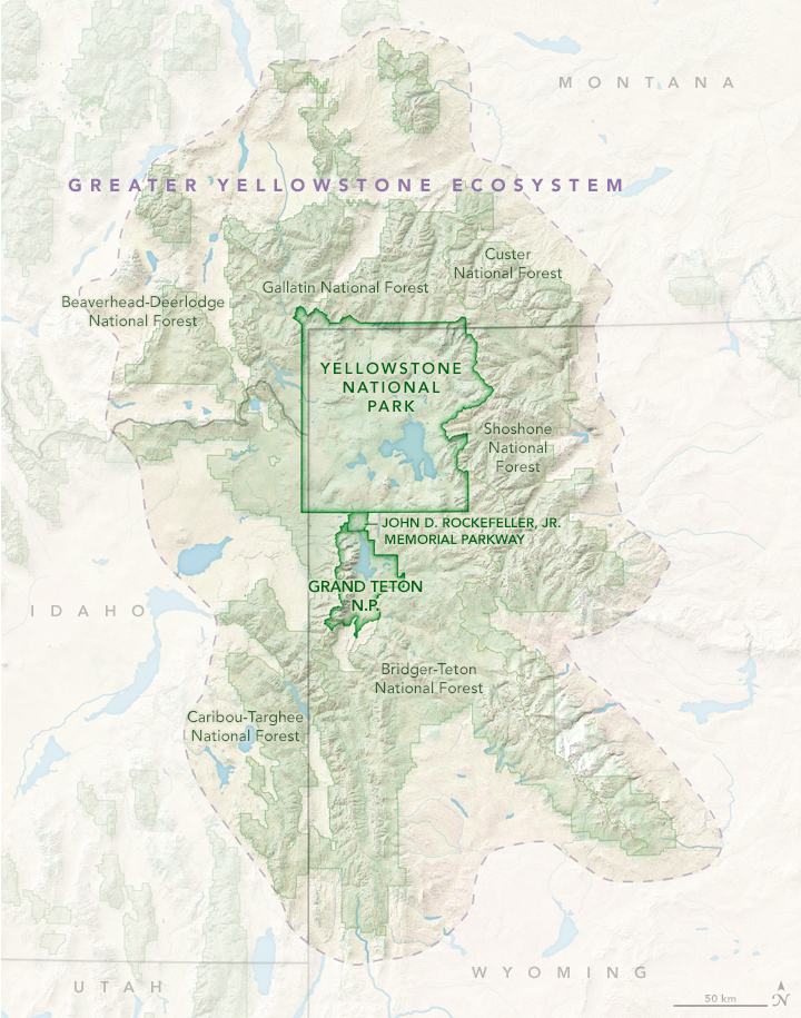
Since 1950, the iconic park has experienced a host of changes caused by human-driven global warming, including decreased snowpack, shorter winters and longer summers, and a growing risk of wildfires. These changes, as well as projected changes as the planet continues to warm this century, are laid out in a just-released climate assessment that was years in the making. The report examines the impacts of climate change not only in the park, but also in the Greater Yellowstone Ecosystem — an area 10 times the size of the park itself.
The climate assessment says that temperatures in the park are now as high or higher as during any period in the last 20,000 years and are very likely the warmest in the past 800,000 years. Since 1950, Yellowstone has experienced an average temperature increase of 2.3 degrees Fahrenheit, with the most pronounced warming taking place at elevations above 5,000 feet.
The Greater Yellowstone Ecosystem. NASA EARTH OBSERVATORY MAP BY JOSHUA STEVENS, USING DATA FROM THE NATIONAL PARK SERVICE AND THE U.S. FISH AND WILDLIFE SERVICE via Yale 360
Today, the report says, Yellowstone’s spring thaw starts several weeks sooner, and peak annual stream runoff is eight days earlier than in 1950. The region’s agricultural growing season is nearly two weeks longer than it was 70 years ago. Since 1950, snowfall has declined in the Greater Yellowstone Area in January and March by 53 percent and 43 percent respectively, and snowfall in September has virtually disappeared, dropping by 96 percent. Annual snowfall has declined by nearly two feet since 1950.
Because of steady warming, precipitation that once fell as snow now increasingly comes as rain. Annual precipitation could increase by 9 to 15 percent by the end of the century, the assessment says. But with snowpack decreasing and temperatures and evaporation increasing, future conditions are expected to be drier, stressing vegetation and increasing the risk of wildfires. Extreme weather is already more common, and blazes like Yellowstone’s massive 1988 fires — which burned 800,000 acres — are a growing seasonal worry.
The assessment’s future projections are even bleaker. If heat-trapping emissions are not reduced, towns and cities in the Greater Yellowstone Area — including Bozeman, Montana and Jackson, Pinedale, and Cody, Wyoming — could experience 40 to 60 more days per year when temperatures exceed 90 degrees F. And under current greenhouse gas emissions scenarios, temperatures in the Greater Yellowstone Area could increase by 5 to 10 degrees F by 2100, causing upheaval in the ecosystem, including shifts in forest composition.
At the heart of the issues facing the Greater Yellowstone Area is water, and the report warns that communities around the park — including ranchers, farmers, businesses and homeowners — must devise plans to deal with the growing prospect of drought, declining snowpack and seasonal shifts in water availability.
“Climate is going to challenge our economies and the health of all people who live here,” said Cathy Whitlock, a Montana State University paleoclimatologist and co-author of the report. She hopes “to engage residents and political leaders about local consequences and develop lists of habitats most at-risk and the specific indicators of human health that need to be studied,” like the connection between the increase in wildfires and respiratory illness. Sounding the alarm isn’t new, but the authors of the Yellowstone report hope their approach, and the body of evidence presented, will convince those skeptical about climate change to accept that it’s real and intensifying.
The report describes a scenario that is now all too common across the American West and in the region’s renowned national parks, from Grand Canyon in Arizona, to Zion in Utah, to Olympic in Washington state. Record warming and extreme drought mean there is not enough fall and winter moisture, leading to steadily declining mountain snowpack. Many iconic venues may soon lose the very features they were named for. Most striking is Glacier National Park in Montana, where, since the late 19th century, the number of the park’s glaciers has declined from 150 to 26. The remaining glaciers are expected to disappear this century.
In Joshua Tree National Park in California’s Mojave Desert, extreme heat — coupled with a prolonged drought — has wreaked havoc on the eponymous species. Because of drought and wildfire, the park is poised to lose 80 percent of its renowned Joshua trees by 2070.
Swaths of Rocky Mountain National Park in Colorado have suffered massive die-offs of white pine and spruce as warming-related bark-beetle infestations have killed an estimated 834 million trees across the state. And in Yosemite National Park in California, the rate of warming has doubled since 1950 to 3.4 degrees F per century. Yosemite is experiencing 88 more frost-free days than it did in 1907. The park’s snowpack is dwindling. Its remnant glaciers are fast disappearing. And wildfires are becoming more common. In 2018, the park was closed for several weeks because of dense smoke from a fire on its border. The National Park Service says that temperatures could soar by 6.7 to 10.3 degrees F from 2000 to 2100, with profound impacts on the Yosemite ecosystem.
Yellowstone River. Snowpack in the Yellowstone area is melting earlier, leading to a decline in summer streamflows. JACOB W. FRANK / NATIONAL PARK SERVICE via Yale 360
The Yellowstone assessment paints a detailed portrait of the past, present and future impacts of climate-related changes.
“This is one of the first ecosystem-scale climate assessments of its kind,” said co-author Charles Drimal, water program coordinator for the Greater Yellowstone Coalition. “It sets a benchmark for how the climate has changed since the 1950s and what we are likely to experience 40 to 60 years from now in terms of temperature, precipitation, stream flow, growing season and snowpack.” Researchers from the U.S. Geological Survey, Montana State University and the University of Wyoming were the lead scientists on the report.
The report’s study of snowpack and its link to water offer the biggest takeaways for Westerners who might question how or why they’re impacted. Rocky Mountain snowmelt provides between 60 to 80 percent of streamflow in the West, and hotter temperatures mean reduced snowfall and less water for cities as far afield as Los Angeles. For the millions of people living in cities across the West, many of whom are reliant on runoff from the snowpack in the Rocky Mountains, these trends jeopardize already insufficient supplies. The dangers are starkly evident this summer, as years of drought and soaring temperatures have left the West facing a perilous wildfire season and water shortages, from Colorado to California.
“All that snow becomes water that goes into the three major watersheds of the West — some of it goes as far as L.A. — and that comes together in the southern edge of Yellowstone National Park,” said Bryan Shuman, a report co-author and geologist at the University of Wyoming. “Looking at projections going forward, that snowpack disappears.”
Wyoming rivers map via Geology.com
The Yellowstone, Snake and Green rivers all have headwaters in the Greater Yellowstone Area, feeding major tributaries for the Missouri, Columbia and Colorado rivers that are vital for agriculture, recreation, energy production and homes. Regional agriculture — potatoes, hay, alfalfa — and cattle ranching depend on late-season irrigation, and less snow and more rain equals less water in hot summer months.
Then there are the rapidly growing tourism and hospitality industries that rely on Yellowstone’s world-class rivers and ski areas for angling and black diamond runs. Fishing is now regularly restricted because of high water temperatures that stress fish.
“Even mineral and energy resource extraction need to be part of this discussion,” said Whitlock, referring to Wyoming’s oil and gas industry, heavily reliant on large amounts of water. Industry may be the slowest to evolve, but it’s among the most at-risk, she said.
Many locals do quietly acknowledge the reality of what’s happening, she said, but community buy-in remains tough in this culture war hotspot, where many farmers and ranchers have long opposed government land intervention.
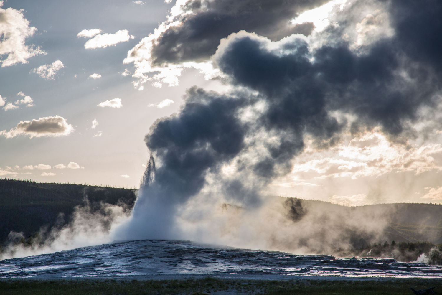
The land in the Greater Yellowstone Area, comprising 34,000 square miles, is among the last, largely intact temperate ecosystems in the United States and includes two national parks (Grand Teton in Wyoming is the other), five national forests, and half a dozen tribal nations. It’s also home to 10,000 hydrothermal features, including 500 geysers. Recent research has shown that in periods of extreme heat and drought, geysers such as Yellowstone’s renowned Old Faithful have shut down entirely.
The current conditions do have some historical precedent. In the last 10,000 years, Yellowstone has experienced periods of dryness equal to or greater than present, said Whitlock.
Electric Peak in Yellowstone National Park. Snowfall in the Yellowstone region has declined as a result of climate change. NEAL HERBERT / NATIONAL PARK SERVICE via Yale 360
“That’s a lens to look at the past,” said Shuman, who once trekked the 3,000-mile Continental Divide Trail to get a sense of the land. “If you add just a few degrees, you fundamentally alter things. When you walk across these high mountains, you can see they used to be covered in glaciers. It’s like walking in the ruins of Ancient Rome. That Ice Age world was only 5- to 7-degrees F colder than the pre-industrial era.”
“The water in those mountains is the water supply of the West and it’s drying up,” said Shuman.
In Yellowstone, the threat to human health and livelihoods may be the strongest incentive to take steps to soften the blows from climate change.
“Water is the thing everyone is most concerned about, and in general, people are receptive,” said Shuman. “Our economic future depends on adjusting.”
Just how the residents of the Greater Yellowstone Area will adapt is an open question, but researchers say that acknowledging the myriad problems that are now daily realities for many, from ranchers to anglers, is the first step toward a productive dialogue.
As the West experiences a growth surge, Cam Sholly, Yellowstone National Park’s superintendent, writes in the report that “the strength of local and regional economies” hangs in the balance if no steps are taken to rein in global warming.
Said Whitlock of Montana State, “When you think about the temperature curve that looks like a hockey stick, my parents pretty much lived on the flat part of the curve, I’m on the base, and my grandkids are going to be on the steep part. Our trajectory depends on what we do about greenhouse gases now. By 2040, 2050, we can flatten the curve. But the business-as-usual trajectory, 10 to 11 degrees of warming in Yellowstone and much of the West — what we do in the next decade is critical.”
The Greater Yellowstone Area includes both Yellowstone and Grand Teton national parks, as well as surrounding national forests and federal land. National Park Service
Grand Prismatic Spring Yellowstone National Park. Photo credit: Pixabay via NOAA
In Yellowstone National Park. Photo credit: Pixabay via NOAA
Yellowstone Falls photo credit Abby Howe via the Department of Interior.
Colorado’s Congressional delegation moves legislation to help address climate crisis
The news about the climate crisis is bleak. The summer started with most of the nation gripped by heat waves smashing records across the continent. Once again the hurricane season is off to a historic start with the earliest fifth-named tropical storm. Last year was the worst fire season that the U.S. West has seen in decades, if not hundreds of years, and this year is likely to be at least as bad. Major rivers are drying up.
We are in a climate emergency and western Colorado is square in the cross-hairs. The alarm is sounding: We must act now, in an urgent and unprecedented manner.
he Gunnison Basin is facing a climate emergency, putting our farm and food systems at severe risk. This map shows the warming that has already occurred in this Gunnison watershed since 1895. It is from our upcoming report on climate change in the region and some steps to take to avert worsening harm. Graphic credit: The Washington Post via the Colorado Farm & Food Alliance
Climate action, generally speaking, needs to do three things to reverse a descent into even greater ecological and social calamity. Importantly, we cannot trade one for the other, which is a bait and switch tactic some industry boosters are now pushing. We need an “all of the above” climate plan (to borrow a favored fossil fuel phrase). We cannot get by pretending, as the erstwhile denialists cum begrudging believers ask us to do, that some new fix will allow business to continue as usual. Instead, we must transform our practices and businesses to meet the needs of this moment.
We need to act, across all sectors, to:
Curb climate pollution.
Keep and return carbon in (to) the ground.
Adapt human systems to be climate-smart and restorative.
These necessary goals are both daunting and full of opportunity. They point to big and rapid change. But each also has the potential to inspire all manner of innovative technology, entrepreneurship, and solutions. So we cannot wait to get started. First we must stop adding to the problem.
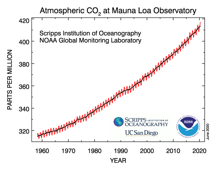
The carbon dioxide data on Mauna Loa constitute the longest record of direct measurements of carbon dioxide in the atmosphere. C. David Keeling of the Scripps Institution of Oceanography began measurements in 1958 at the NOAA weather station. NOAA started its own CO2 measurements in May of 1974, and they have run in parallel with those made by Scripps since then. Credit: NOAA and Scripps Institution of Oceanography.
This year atmospheric concentrations of carbon dioxide have reached toward 420 ppm. Many places are already experiencing heating above the 1.5 degree threshold we are to avoid, as set by international accord. Ice caps, permafrost and glaciers are melting, sea levels rising, biological diversity collapsing: the ecological systems that have long allowed human civilization to flourish are in severe crisis. There is no time to paper over or “both sides” the situation we are in: If we do not act boldly and quickly, our livelihoods, our businesses, and our ability to prosper in the U.S. Southwest are all at severe risk.
The action required is monumental and we should not shy from declaring it as such. And just acknowledging that and reversing course can signal a shift in momentum. But the effort needs to accelerate if we are to avoid even more damaging heating ahead.
We cannot claim to be moving forward if for every small step ahead we continue to take several back. Fortunately in Colorado we do have elected leaders who are at least taking these first steps. So we want to acknowledge these action and encourage more that must follow. And we should stay on guard for back-sliding or double-speak.
Colorado Congressional Leaders Take Action
The Grand Junction Sentinel reported, in a June 23rd article by reporter Dennis Webb that “U.S. Sen. Michael Bennet, D-Colo., is again pushing for passage of bills that would boost funding for cleanup of abandoned, or orphaned, oil and gas wells on federal lands and boost the opportunities for public comment when federal oil and gas lease sales are proposed.”
And last week, President Biden signed a law limiting methane pollution from oil and gas on public lands, a bill sponsored by Colorado congresswoman Diana DeGette. CNN reported: “President Joe Biden on Wednesday signed a bill repealing a Trump-era rule that rolled back regulations on methane emissions — a particularly potent greenhouse gas believed to contribute significantly to the climate crisis — from the oil and gas industries. The President described the bill as an “important first step” to cut methane pollution and said it “reflects a return to common sense and commitment to the common good.”
We applaud these steps. But it must be just the start of an “all of the above” approach to climate action if we are to avert worsening catastrophe. And we must make sure that we are not making the problems worse. Our priorities for public lands should be on conservation and restoration. We should limit the further expansion of fossil fuel development.
The first bill introduced by Sen. Bennet would increase bonding and clean-up requirements for oil and gas on public lands. This may seem minor, but is a critically important fix to a badly broken system. Our public lands fossil fuel leasing and development programs have long put the interests of corporations ahead of both the health of the lands and the interests of the public — and the public ends up paying for it, time and again.
The second piece of legislation from Sen. Bennet improves public oversight and community involvement processes around the oil and gas programs. This too is a small, but vitally important, step. It would begin to re-center community concerns–including the need to address the climate crisis– in public lands management. For too long the scales have been tipped toward the oil and gas industry.
That is why the Colorado Farm & Food Alliance recently issued a statement in support of Senator Bennet’s bills which would start to re-balance the scales in favor of the public, toward greater accountability, and in favor of resource protection.
The climate emergency is real and brings grave risk and an urgent need for action. We must move quickly away from fossil fuels. An obvious place to start is with our public lands, which provide so much from water sources, to critical wildlife lands and popular recreation areas. We have an opportunity to to rethink the purpose of these cherished lands and to model the leadership needed to take the climate crisis head on.
Agriculture in the U.S. Southwest is at high risk from the impacts of climate change. EcoFlight photo of the North Fork Valley by the Western Slope Conservation Center.
The International Energy Agency has noted: “A rapid shift away from fossil fuels [is required].
While these three acts, one now law and two others pending, before Congress are just tweaks to the federal land oil and gas program — they add critical side-boards that will limit the expansion and harm of this activity on our National Forests and other public lands. Still, we must do much more, and continue to enact reforms that move us rapidly beyond fossil fuels and curtail the further expansion of this activity on public lands.
“Net zero means huge declines in the use of coal, oil and gas. …[Efforts must] include, from today, no investment in new fossil fuel supply projects….” — The International Energy Agency
Because, if we are serious about responding to the Climate Emergency then it is time we act like it.
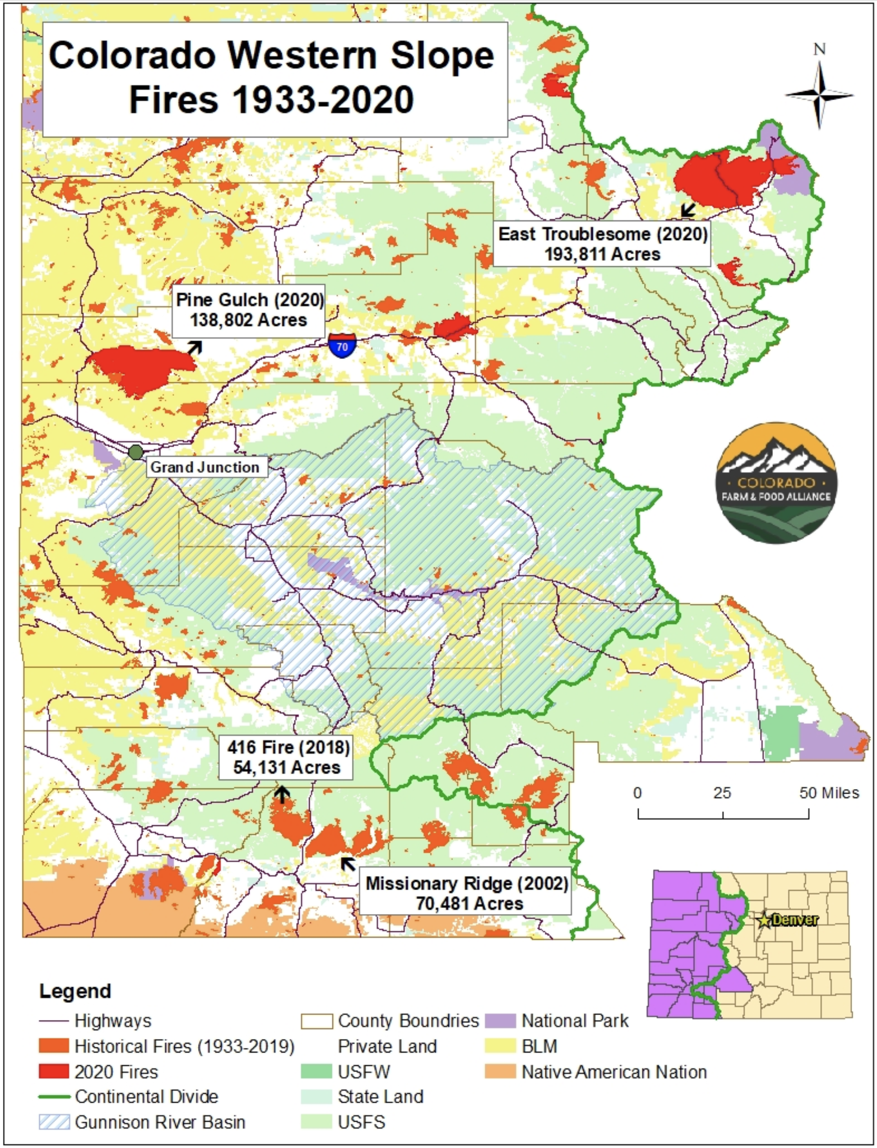
Wildfire season is becoming longer and worse across the West as the twin effects of heat and drought but more forests and grasslands at risk. This map from our up-coming report depicts the changing patterns of fire on the Western Slope since 1933.
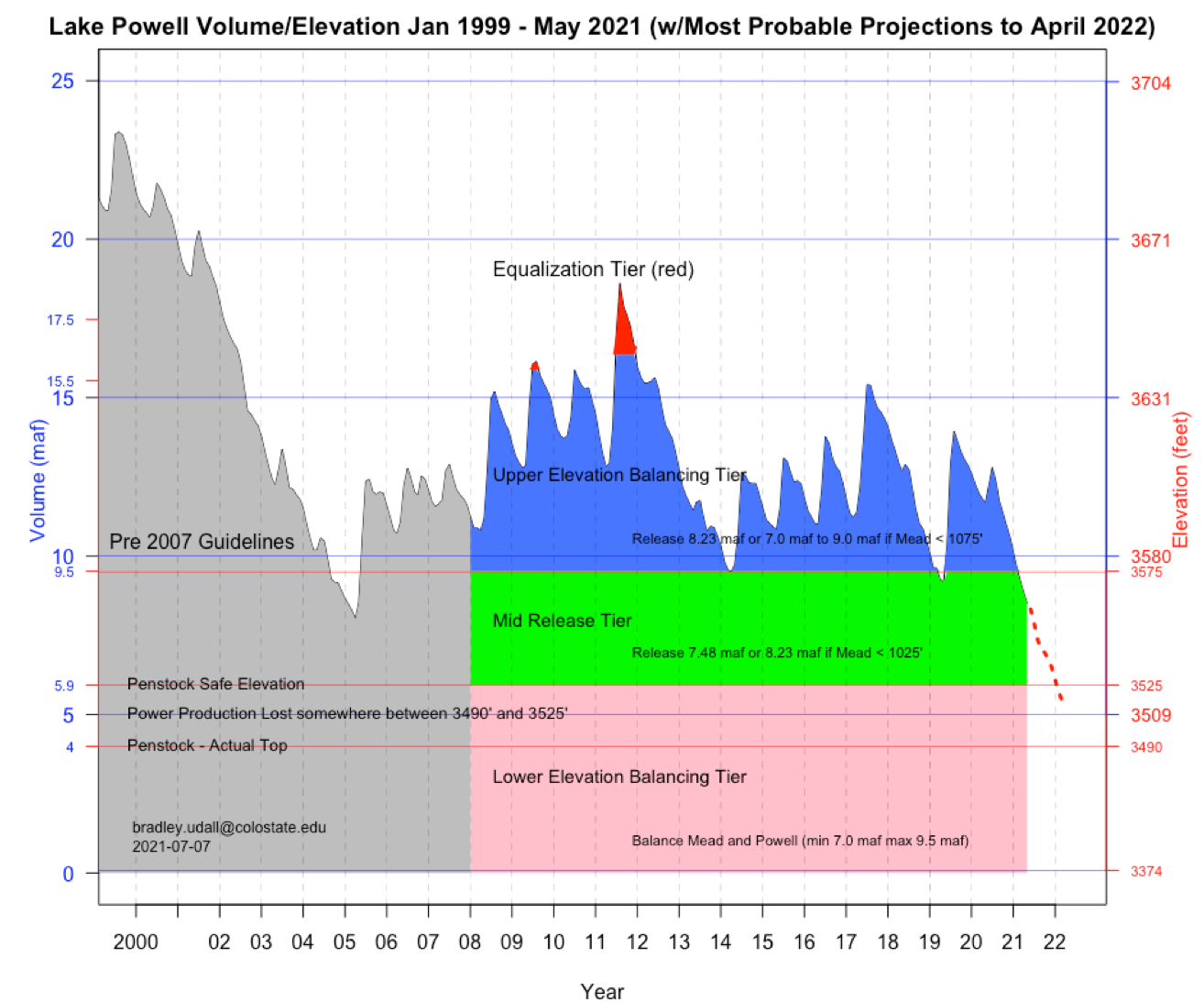
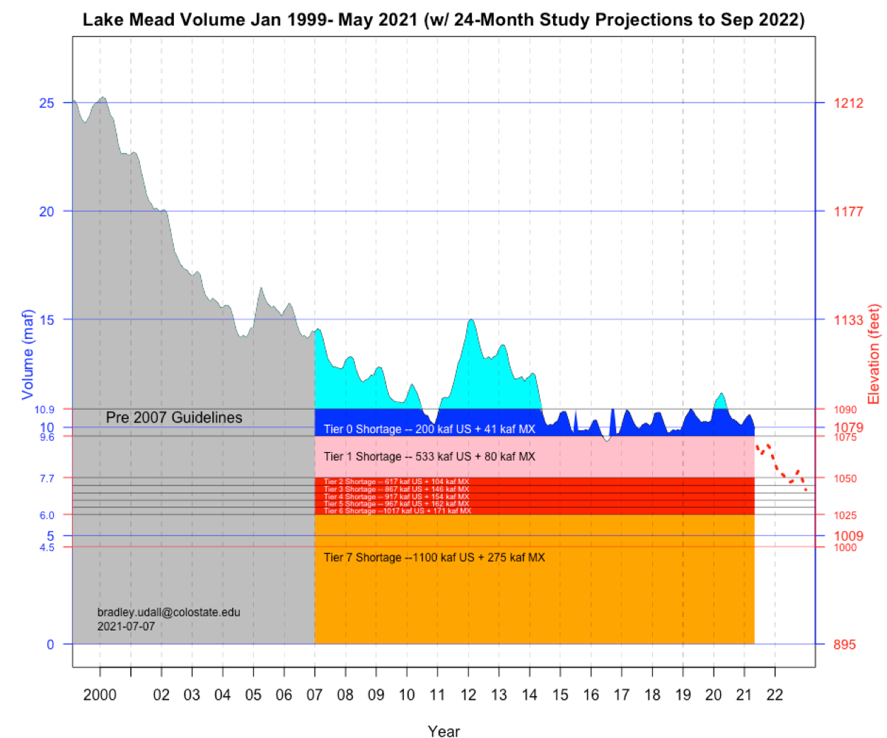
Brad Udall on twitter yesterday ran through a striking series of graphs of the current state of the Colorado River. With his permission, I’m posting them here along with a slightly polished version of his accompanying commentary. Some key points that grabbed my attention:
Second-lowest Powell inflow in a period of record we use dating to 1964.
Risk of Powell dropping next year to levels that could jeopardize power production.
Risk of Mead dropping low enough in the next 18 months to trigger much deeper “Tier 2” reductions to Lower Basin water users in 2023.
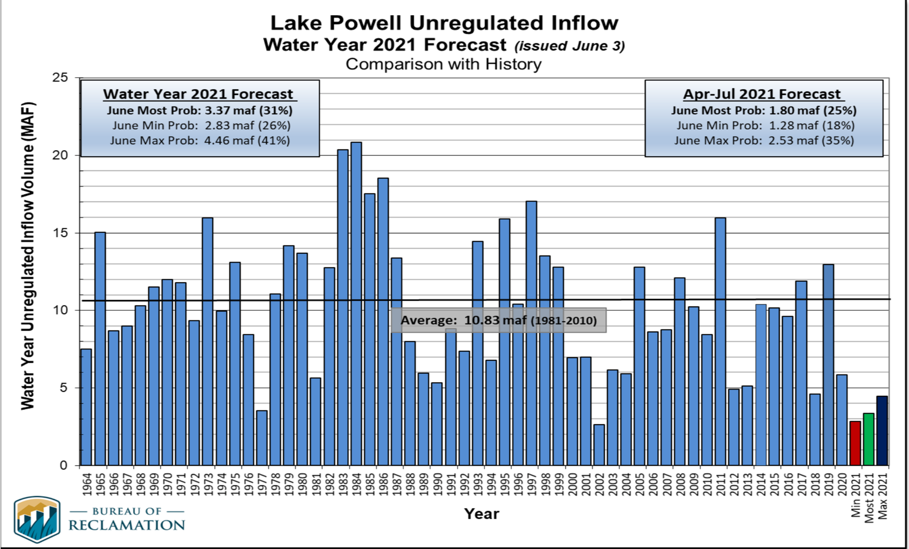
Reclamation’s ‘unregulated inflows’ into Lake Powell show that 2021 will be the 2nd worst year after only 2002 going back to 1964. 2021 will be the RED bar most likely. This is a really grim year for runoff.
Graphic credit: Bureau of Reclamation via Brad Udall
2021 inflow will be only ~3 maf, compared to the 1981-2010 average of 10.3 maf or the 2000-2021 average of 8.3 maf (20% less than 1981-2010 average).(maf = million acrefeet)
Considering that Powell will release or lose to evaporation ~ 8.5 maf, the lake will lose ~ 5 maf this year or ~55 feet of elevation.
April 2021 snowpack above Powell peaked at ~85% of normal but will generate about 25% of normal river flow. This comes on top of April 2020 snowpack of 100% of normal that generated about 50% of normal flow.
Declining runoff efficiency has been noted in multiple peer-reviewed studies. For a recent overview of recent climate change studies on the Colorado River see this written with Jonathan Overpeck:
Jeff Lukas points out that the twitter thread implied that the low runoff efficiency this year as measured by runoff as a percent of snowpack is all due directly to warming. I did not mean to imply that. The low runoff percent numbers are much more a function of (1) very low spring precipitation in both 2020 and 2021 and to a lesser extent (2) low soil moisture from the previous year. It may be that there is a human-caused connection to the low spring precipitation although there’s no real evidence of this yet. Low soil moisture in the springs of 2020 and 2021 is definitely connected to dry and very warm late summer and early fall from the previous years. Teasing this apart to obtain the actual driver(s) is not simple. That said, no one should doubt that climate change is reducing the flows of the Colorado. Multiple peer-reviewed papers have now supported this finding.
Here’s what’s going to happen to the nation’s 2 largest reservoirs because of this measly inflow:
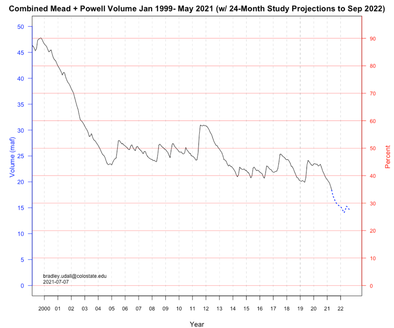
Losses to Mead and Powell. Graphic credit: Brand Udall via InkStain
Note that combined contents will drop below 30% by late next year.
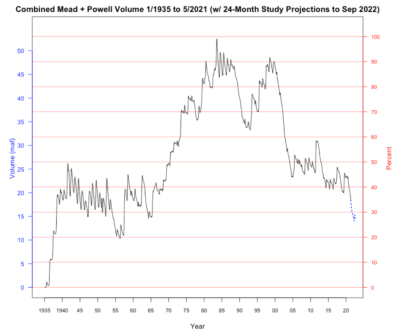
Here’s that decline for all years back to 1935 when Mead first filled. These two reservoirs will hold less water than Mead did alone in many years before 1964 when Powell was built.
Combined storage, Mead and Powell. Graphic credit: Brad Udall via Inkstain
By next April Powell will hit 5.4 maf, ~185 feet below full. See Red dots. This will be the lowest since its initial fill in 1964. Since 1999, Powell will have lost ~18 maf, 75% of its contents.
Graphic credit: Brad Udall via InkStain
At 5.4 maf Powell could be low enough to lose the ability to generate power. (We’re uncertain about how penstocks operate when lake gets low — water in penstocks can not be aerated or turbine damage will occur.)
Loss of power, while not calamitous, is concerning. Power revenues fund environmental compliance and other important items in the basin.
As part of the 2019 agreement, the UB can release flows from reservoirs upstream of Powell to prop it up. But there is only about 5 maf for that all together. It is a one-shot deal.
We’ll have to wait on next winter to understand what happens after April of 2022. But 5.4 maf is very little water in a 25 maf reservoir.
So what about Lake Mead, the nation’s largest reservoir?
Reclamation’s current forecasts show January 1, 2022 elevation at 1065’ feet (8.8 maf) , well below the 1075’ needed to avoid a ‘Tier 1 Shortage’.
Decline of Lake Mead. Graphic credit: Brad Udall via InkStain
If it ends up below 1050’ on Jan 1 (as projected in August 2022), that will lead to a Tier 2 Shortage (total cutbacks of 721 kaf). Otherwise, Mead will face a 2nd year of Tier 1 shortages. Either way, this is not good.
A high desert thunderstorm lights up the sky behind Glen Canyon Dam — Photo USBR
Hoover Dam photo via the US Bureau of Reclamation
Here’s the release from the Bureau of Reclamation:
As one element of the ongoing implementation of the 2019 Drought Contingency Plans for the Colorado River Basin, the Bureau of Reclamation today released additional 5-year projections on the Colorado River System based on June 2021 conditions.
Five-year projections are typically modeled in January, April and August of each year. The additional June projections will inform the ongoing drought operations planning efforts at key Reclamation reservoirs in the Upper Colorado River Basin. These efforts are ongoing among Reclamation and the Colorado River Basin states under the Upper Basin Drought Response Operations Agreement.
“The June 5-year projections for the Colorado River System reaffirm this is a serious situation,” said Wayne Pullan, Upper Colorado Basin Regional Director. “We are actively engaged with the Colorado River Basin states and other partners to respond to changing conditions to avoid critical elevations at Lake Powell.”
Projections for anticipated runoff in the Upper Colorado Basin have declined over the course of the spring. Using information based on recent hydrology (since 1988 and known as the Stress Test Hydrology), Reclamation notes several key findings for Lake Powell in the June 5-year projections:
A 79% chance that Lake Powell will fall below its target water-surface elevation of 3,525 feet sometime next year.
Lake Powell’s target water-surface elevation of 3,525 feet provides a 35 vertical-foot buffer designed to minimize the risk of dropping below the minimum power pool elevation of 3,490 feet, and balances the need to protect the infrastructure at Glen Canyon Dam and to meet current operational obligations to the Lower Colorado River Division states of Arizona, California, and Nevada.
Beyond 2022, Lake Powell’s chances of falling to critical levels also increased.
There is a 5% chance that Lake Powell will fall below minimum power pool elevation of 3,490 feet in 2023 and 17% in 2024.
In the Lower Basin, the updated projections for Lake Mead continue to affirm the high likelihood of a first-ever shortage condition in the Lower Basin in calendar year 2022. Consistent with the 2007 Interim Guidelines, if Lake Mead’s end-of-calendar-year elevation is projected to be at or below 1,075 feet, Lake Mead would operate in a shortage condition in the upcoming year. The prescribed shortage reductions for Arizona and Nevada would also be coupled with water savings contributions under the Lower Basin Drought Contingency Plan. Mexico would reduce their allotment and make water savings contributions under Minute 323 to the 1944 U.S. Mexico Water Treaty. Consistent with the 2007 Interim Guidelines, the 2019 DCP and Minute 323, operational decisions for 2022 will be made by Reclamation in August 2021.
Reclamation is also concerned with the longer-term projections, which show a higher likelihood of Lake Mead declining to the critical elevations of 1,025 and 1,000 feet by 2025. Based on the June update, the chance of this occurring by 2025 is 58% and 21%, respectively.
Reclamation provides projections using two future hydrology scenarios: The Stress Test Hydrology based on the last 32 years, and the Full Hydrology based on the last 114 years. The Stress Test Hydrology provides more plausible near-term outlooks because it embeds the recent warming trend and current drought period. It is about 11% lower on average compared to the Full Hydrology.
Assumptions about drought operations are included in these projections; drought response operation plans to protect Lake Powell are being developed by Reclamation and the Upper Division states of Colorado, New Mexico, Utah, and Wyoming. Pursuant to the provisions of the Drought Response Operations Agreement and the Companion Agreement, Reclamation will consult with the Lower Division states before finalizing drought response operation plans. If actual hydrology demonstrates an imminent need to protect the elevation at Lake Powell, the Secretary retains all applicable authority to adjust releases from the upstream initial units of the Colorado River Storage Project Act (Flaming Gorge, Navajo, and Blue Mesa reservoirs) before those operating plans can be finalized.
Reclamation and the Colorado Basin states continue to closely monitor conditions to be prepared to meet the goals of the DROA in the months and years ahead.
A key component of Reclamation’s Colorado River Basin activities is the integration of sophisticated modeling tools and scientific research to inform water management decisions. Through a decades-long partnership with the Center for Advanced Decision Support for Water and Environmental Systems at the University of Colorado in Boulder, Reclamation hydrologic engineers and hydrologists are actively collaborating with climate, hydrology and decision support scientists to provide advanced modeling tools. Their work is helping Reclamation link advances in science to water resource management decisions in the face of greater uncertainty and increased hydrologic and operational risks.
Reclamation’s modeling and operations teams further refine these tools, such as the 24-Month studies, to make annual operational determinations for Lake Powell and Lake Mead through close coordination with water and power customers throughout the basin.
From RiversEdge West via The Grand Junction Daily Sentinel:
Tamarisk trees, those green bushy plants seen along waterways, have been turning brown across the county thanks to a special beetle used to control the invasive species.
Ben Bloodworth, Tamarisk Beetle Program coordinator with RiversEdge West, sent out a note Monday responding to social media posts from local people wondering why they were seeing so many browning tamarisk plants.
“These are tamarisk trees, or salt cedars, and the phenomenon is currently so pervasive here in the valley that folks are starting to wonder about it on social media,” Bloodworth said. “So, before you blame anyone for over-spraying, or the hot, dry air of June, let’s chat about the millions of little beetles that live in the valley with us.”
According to Bloodworth, tamarisk, which is native to Asia and the Mediterranean, became such an environmental and economic problem in the western United States that the U.S. Department of Agriculture (USDA) decided to research and release a biological control agent to address the issue.
“Biocontrols are natural ‘predators’ that feed on plants in their native ranges but are not found in the U.S.,” Bloodworth said. “In 1987 the USDA began a program to find natural enemies of tamarisk and see if they could live and feed on tamarisk in North America without feeding on anything else.”
Out of hundreds of candidate species, the tamarisk beetle was found to be the most successful. It was found to only feed on tamarisk and not any other species of plants. So the USDA began releasing it, including in Moab, Utah, in 2001. From there the beetle spread up the Colorado River to Mesa County.
“Since tamarisk beetles survive on tamarisk as their only food source, they were never intended to eliminate the invasive plant,” Bloodworth said. “Rather, they were released to help control the spread of the plant and reduce the amount that land managers must remove by other, more costly means.”
The small green beetles, when there is a large enough population, can defoliate a large amount of tamarisk in just a few weeks. Left behind are the orangish brown remains of the formerly green tamarisk.
“The populations ebb and flow with available tamarisk and some years we have almost no tamarisk beetles anywhere,” Bloodworth said. “As you may have noticed by all the brown tamarisk, this is not one of those years!”
Counterintuitively the brown, dead tamarisk is actually less of a fire danger than the green plant, Bloodworth said. It may initially, for a few weeks, be more susceptible to catching fire, but once it has dropped its leaves it is actually less of a fire risk, according to Bloodworth.
“The brown trees may not be pretty, but they do provide for opportunities to restore native vegetation alongside our rivers,” Bloodworth said.
2014 Tamarisk leaf beetle distribution map via the Tamarisk Coalition
Here’s the release from Colorado Parks & Wildlife (Travis Duncan):
Due to extremely low flows and warm water temperatures, Colorado Parks and Wildlife is asking anglers to voluntarily avoid fishing on the Colorado River between Kremmling and Rifle.
Effective Wednesday, July 7, CPW is placing a full-day voluntary fishing closure on the Colorado River beginning at the Highway 9 bridge in Kremmling downstream to the Highway 13 bridge in Rifle. The voluntary closure will remain in effect until further notice, with a possibility of a mandatory emergency closure to all fishing if conditions worsen.
“We know that anglers care deeply about this fishery,” said CPW Aquatic Biologist Lori Martin. “We need their help to conserve this resource.”
Because of the ongoing drought, flows are down in the river. The USGS gauge on the Colorado River at Catamount Bridge typically measures between 1,500 and 2,000 cubic feet per second (cfs). The gauge has been measuring 600 – 700 cfs, about half what is historically expected there. The USGS gauge on the Colorado River near Dotsero is running at 1,250 cfs, down from an expected 3,000 – 4,000 cfs.
CPW’s aquatic biologists on the West Slope are concerned about critically high water temperatures and possible low dissolved oxygen. Some fish mortality has already been observed this summer. In addition to these issues, another factor unique to this year has been multiple mudslides and flash flood events resulting from last year’s fires. This has increased the sediment load in some river sections.
“With the high sediment load, the fish can’t find clear water,” said CPW Aquatic Biologist Kendall Bakich “They’ve got to sit through those conditions. And at nighttime, the temp isn’t coming down enough, so there’s no recovery for those fish right now. They’ve just got to hang on.”
These conditions aren’t just limited to the Colorado River.
“We’re likely looking at moving into a voluntary fishing closure on the Yampa River from the upstream boundary of the Chuck Lewis State Wildlife Area downstream to the west city limits of the town of Steamboat Springs,” said CPW Aquatic Biologist Bill Atkinson. “Water temps surpassed 75 degrees on Tuesday, so if it hits 75 degrees on Wednesday, the closure will be implemented.”
Biologists are also closely monitoring the Fraser and upper Colorado Rivers in Grand County, another area where temperatures are edging toward dangerous levels for trout.
Anglers should be aware that most of the major rivers on Colorado’s Western Slope are experiencing adverse conditions heading into the hottest days of summer. Follow the Leave No Trace Principle to “Know Before You Go” to the West Slope this summer and check out conditions related to mandatory and voluntary fishing closures: https://cpw.state.co.us/thingstodo/Pages/StatewideFishingConditions.aspx
Tips for anglers
CPW is encouraging trout anglers to consider fishing early in the day and in higher altitude lakes and streams as hot, dry conditions and reduced water levels increase stress to trout populations.
Heat, drought, and low water levels are contributing to elevated water temperatures in much of Colorado, depleting oxygen levels and leaving trout vulnerable. Trout are cold-water fish that function best in 50-60 degree waters. When temperatures exceed 70 degrees, they often stop feeding and become more susceptible to disease. Warm temperature and low water levels can also lead to algae blooms in rivers and reservoirs which cause oxygen levels to drop when algae die and decompose.
Anglers are asked to carefully consider the water and weather conditions when they go fishing for trout. If water seems too warm or fish appear lethargic, it would be best to leave the fish undisturbed. During mid-summer, try to fish early in the morning when the water is coolest.
“Get out early to avoid the higher water temperatures commonly seen in the afternoon and evening,” Martin said. “Anglers are also encouraged to seek out high-elevation trout lakes and streams, where water temperatures are more suitable and fishing doesn’t potentially add additional stress.”
Martin also urged anglers to add a hand-held thermometer to their fishing kits so they can test the waters they intend to fish.
“Anglers should monitor water temperatures and stop fishing when water temperatures start to approach 70 degrees,” she said. “If trout have difficulty recovering after being caught and are acting lethargic, it’s a good decision to call it quits for the day.”
Other suggestions include using heavier tippet and line to quickly reel in and release the fish, always wetting your hands before handling a fish, and to keep the fish submerged while unhooking and releasing it. Avoid taking the fish out of the water even for a quick photo in these conditions.
The Snake River Water District is planning ahead for increasing water needs in the Keystone area due to population growth over the past decade.
District Executive Director Scott Price said in a statement that the district recently created a water system master plan looking into emerging challenges in the next 10 years. The plan includes a prioritized list of short- and long-term projects.
According to the plan, the district needs to invest $38.5 million over the next decade to address trouble areas, update the old water treatment plant and add a new pump station and storage tank. The district is currently seeking grants and loans to help fund the improvements. It is also evaluating user rates that have remained unchanged for the past eight years.
The district will hold public meetings with key stakeholders to discuss the financial plans. There will be two public meetings July 22, including a 1 p.m. livestream on the district’s Facebook page and an in-person meeting at 6:30 p.m. at the district’s office in Keystone, 0050 Oro Grande Drive.
Lake Powell is seen in a November 2019 aerial photo from the nonprofit EcoFlight. Keeping enough water in the reservoir to support downstream users in Arizona, Nevada and California is complicated by climate change, as well as projections that the upper basin states of Colorado, Utah, Wyoming and New Mexico will use as much as 40% more water than current demand. A recent white paper from a lineup of river experts calls those use projections into question. CREDIT: ECOFLIGHT via Aspen Journalism
Polis signs latest $20 million infusion for Colorado Water Plan as hotter, drier climate grips Southwest
Colorado Gov. Jared Polis has signed off on increased funding for water development projects that state officials regard as critical to meet growing demands. But the state’s plans to secure more water from rivers here are colliding with the hotter, drier climate that’s hammering the Southwest, where Colorado River reservoirs are at record-low levels.
Federal authorities warn hydropower electricity for millions of people (and their air conditioners) could be jeopardized if water levels in Lake Powell and Lake Mead — now both about 34% full — fall much lower. That’s partly why water officials from seven states met in Denver this week to size up perils before their next round of negotiations over how states deal with diminishing water.
Colorado, New Mexico, Utah and Wyoming (the Upper Basin states along the Colorado River) are facing pressure from Lower Basin states (Arizona, Nevada, California) to use less water — even though the 1922 Colorado River Compact legally entitles them to use more — to try to save the downriver reservoirs.
“There’s a reality that we do have a shrinking water supply and we’re all going to have to figure out new ways to reduce our use. We try to stay out of any state’s business, but we also realize there’s not enough water for the Upper Basin to use its full allotted water under the compact,” said Bill Hasencamp, the Colorado River resources manager for the Metropolitan Water District of Southern California, which serves 19 million people in the Los Angeles area and San Diego…
Colorado leaders over the past six years have awarded more than $500 million in grants and loans for 323 projects in carrying out the state’s water plan — which calls for $100 million a year through 2050. Polis last week signed the latest monetary infusion into law: HB21-1260 for $20 million more to the Colorado Water Conservation Board to go toward increased water storage capacity and supply. The bill provides $15 million for loans and grants and $5 million for the regional “roundtable” panels that have planned 500 local water development projects.
Polis also signed off on SB21-189 to spend $1.2 million more in construction funds for the implementation of the overall $20 billion water plan, which was launched in 2015 to ensure enough for a productive economy — from cities to farms to the recreation industry — while preserving healthy rivers through efficient water use and carefully designed water projects. Two in progress would siphon significantly more water out of the Colorado River basin — an expanded reservoir for Denver and enlarged Moffat system that diverts west-flowing water to the northern Front Range…
“We are already actively talking about and experiencing cuts, which have been particularly painful in this very dry year,” [Rebecca Mitchell] said, referring to the state’s allocation system that forces junior water-rights holders to use less in dry times. “These are historically low conditions and we need basin-wide solutions that we work on together.”
State officials in Colorado, Utah and Wyoming contend they’re entitled under the 1922 compact to use as much as 2 million acre-feet more water. But those shares are based on century-old calculations for how much water the river can provide — 15 million acre-feet a year — rather than the 12.3 million acre-feet average total flow since 2000.
Contingency plans for enduring severe droughts are expected to force mandatory cutbacks next year in Arizona, Nevada and Mexico.
Cross Mountain Ranch, a sprawling cattle, guest and hunting operation near Maybell and the Yampa’s confluence with the Little Snake River, needed water to flood meadows for sheep and other livestock.
But there was nothing left to divert into the ranch’s ditch at Lily Park. A state official’s snapshot from the time shows no Yampa there at all — just a gravel bar with a stagnant puddle at the base.
The ranch may be far down river, but it’s high in priority. Under Colorado water law, that means the ranch long ago secured water rights that are vastly senior to many other users on the river. So if the ranch needs it, the state water engineer has to put a “call” on the Yampa and tell junior holders upriver to stop using, letting their water flow on toward Cross Mountain and the Utah border.
Yampa division engineer Erin Light did just that for the first time ever in 2018. She has an 80-page list of descending water rights holders on the Yampa. The ranch is on page one.
The easiest way to find enough water to meet the ranch’s rights was to call Craig Generating Station, a massive coal-fired electricity plant holding a variety of river rights and reservoir shares in the Yampa basin. The power station, managed by Tri-State Generation and owned by a variety of Western utilities, has been cooperative on water issues, Light said, and quickly sent more water downstream.
Then it happened again in 2020. Drought. A nearly dry river by the time the Yampa neared Dinosaur National Monument. And an official state call.
Yampa River at Stagecoach Res Inlet 10 CFS 5-24-21 May 2021. Photo credit: Scott Hummer
This year, the Yampa is looking severely troubled again. It’s no longer a fluke, but a trend. And so Light has asked her boss, state engineer Kevin Rein, to approve her 15-page memorandum and request declaring the Yampa officially “over appropriated.”
Too many users have divided up the river’s dwindling water too many ways, and future ditch diggers and well drillers need to be warned. Dozens of new water rights applications hit the water court for Yampa claims every year, she added…
Yampa not alone under drought pressure
The Yampa isn’t the first Colorado river to suffer the indignity of an official declaration of over appropriation. In fact, most of the major rivers were divided too many ways decades ago and therefore need to be managed down to the drop, from the South Platte on the Front Range, to the Arkansas and the Poudre.
But the fact it’s happening to the Yampa, long running relatively wild and free through the thinly-populated open range of northwest Colorado, is a clear danger sign, according to state officials and conservation groups. Drought in the short term and climate change in the long term are overlaid by relentless economic growth throughout Colorado, turning debates over water use from a distant worry into a current event…
West Drought Monitor map June 29, 2021.
Light’s detailed memo justifying the over appropriation declaration for the Yampa noted that water volume delivered by the river has fallen in recent decades from a norm of 1.5 million acre-feet a year to 1.1 million acre-feet. At the U.S. Geological Survey’s Maybell gauge on the Yampa on Friday, the river flowed at about 340 cubic feet per second, less than 16% of the median figure for that day in 105 years of recordkeeping…
So what would state approval of the over appropriation designation mean in practical terms for northwestern Colorado counties? Developers seeking to drill a new well in the Yampa Basin will see new state scrutiny of their plans to make sure they are not drawing down river water already owned by a senior rights holder. If Light thinks there would be damage, she can require the developer to augment the loss with a different supply, such as stored reservoir water or a pond capturing water during higher runoff periods…
Anyone with an improperly permitted well will also face new reviews, and demands for augmentation. Because of the way Colorado’s rivers and water tables behave, state engineers consider wells to be drawing down river water just as if they were taking it from the river’s surface.
People could still apply for new surface rights from the Yampa, but they will be warned, Light said, that their supply is likely to run out by August or September when senior rights holders put in their call to protect what they need.
Denver Water cuts back on some of its West Slope supplies to help struggling streams.
The Colorado River is hurting.
The struggles of the river’s largest reservoirs, Lake Mead and Lake Powell, have been well documented over the last decade as drought has ravished the West.
The story, however, starts more than 500 miles upstream in Grand County, Colorado.
The county is filled with streams that make up the beginning of the mighty Colorado’s journey in the mountains north of Grand Lake. Around 60% of the water in Grand County is diverted from these streams and used for agricultural and municipal water supply, mostly on the Front Range.
That includes the Denver metro area, which receives about 20% of its water from Grand County, where Denver Water has water rights dating back to the 1920s. Most of the water is captured in rivers and streams around Winter Park when mountain snow melts in the spring.
Rivers and creeks in Grand County are part of Denver Water’s North Collection System. Water flows through the Moffat Tunnel, under the Continental Divide, to Gross and Ralston reservoirs. Image credit: Denver Water.
But, after a lackluster runoff season on the West Slope combined with dry soils from the past year, the hot, dry conditions in early June meant the high-country rivers and streams needed help.
Denver Water responded by voluntarily reducing diversions from several Grand County creeks and coordinating with the Colorado River District, Grand County, Northern Water and other Learning By Doing partners to adjust operations, where possible, to help boost water levels in some of the more troubled areas.
“While our primary responsibility is to make sure we’re supplying water to 1.5 million people in the metro area, we’re always looking for opportunities to help improve conditions on the rivers, to help the aquatic environment, recreation and communities they flow through,” said Nathan Elder, Denver Water’s manager of water supply.
By reducing diversions, Denver Water foregoes collecting a portion of water it is legally entitled to collect for its water supply in exchange for improving streams and tributaries along the Colorado River.
The Fraser River flows below a Denver Water diversion structure in Grand County in June 2021. Denver Water voluntarily released around 11,000 acre-feet of water from streams in the county from June 6 through early July in 2021 to improve aquatic habitat downstream. Photo credit: Denver Water.
It started with a plea for help
On June 5, the Colorado River District asked Denver Water for help after reporting extremely low water levels and critically high water temperatures on the Colorado River. The river district reported conditions were creating unhealthy habitat for fish and aquatic insects.
“When the email came in Saturday morning, we were in a position to quickly respond and reduce the amount of water we were pulling from several Grand County creeks,” Elder said.
Denver Water has continued making operational adjustments since that email.
The utility estimates that by early July it will have voluntarily foregone collecting around 11,000 acre-feet of water from Grand County to help keep more water in the Colorado and Fraser rivers. That’s roughly enough water to supply over 44,000 residences for one year.
“It has been helpful to hear directly from stakeholders in Grand County, including Trout Unlimited and ranchers along the river, on where we may be able to truly help the river, the community and the environment with our operational adjustments,” Elder said.
“With help from the West Slope, we’ve been able to target specific areas and send some beneficial water downstream.”
This includes adjusting water releases from Williams Fork Dam twice a day in a way that also benefits the Colorado River.
For example, when releasing water from the dam, Elder and his team try to time the flows, so the water reaches the river in Kremmling — an area prone to higher river temperatures — during hotter times of the day.
The higher water level helps to cool down the water, which is better for the aquatic environment.
Warm temperatures and low water levels create unhealthy conditions for fish in Colorado streams. Denver Water worked with the Colorado River District to send cooler water downstream in June to help lower temperatures on the Colorado River near Kremmling. Photo credit: Denver Water.
Position to help
The wet spring conditions along the Front Range boosted water supplies in Denver Water’s South Platte River collection system, which drastically reduced customers’ demand for water across the metro area — where Denver Water serves a quarter of the state’s population.
In fact, from January to May, Denver Water’s customer water use hit a 50-year low across the metro area, despite nearly 600,000 more people in its service area since 1970. That includes years in which the metro area was on mandatory drought restrictions.
“Some of the low use may be due to COVID-19 impacts on business and obviously a wet, cool spring helped,” said Greg Fisher, demand manager for Denver Water.
“It’s a great sign that our customers really understand efficient water use and let Mother Nature do the watering for them when possible.”
This wet spring on the Front Range also helped provide additional flexibility on how Denver Water collected and distributed water across its collection system during the spring snow runoff.
“We were able to turn off the Roberts Tunnel in April, which helped bring water levels up in Dillon Reservoir for boating,” Elder said.
“The conditions also enabled us to send more water down the Blue River below Dillon Dam to help improve fish habitat around Silverthorne instead of sending the water to the Front Range.”
Denver Water uses the Roberts Tunnel to bring water from Dillon — the utility’s largest reservoir — under the Continental Divide to the Front Range.
But flexibility like this is not always possible, especially with the myriad threats Denver’s water system is facing.
“Between the rising temperatures, changes to the timing of spring runoff, extreme fire behavior and half a million more people expected in the metro area by 2040, our ability for flexible operations is decreasing in a time when we need it the most,” said Elder.
“We must take an ‘all-in’ approach that includes conservation, water reuse and development of new water supplies so we can continue to maximize the benefits of a large system.”
Wet conditions in the metro area during the spring of 2021 reduced demand for water for irrigation. The lower demand gave Denver Water more flexibility to fill its reservoirs and provide additional water for environmental benefits on the West Slope. Photo credit: Denver Water.
More flexibility
According to Elder, hot, dry weather conditions highlight the benefits of having a large water collection system, as it provides the water planning team more flexibility in its operational playbook.
Denver Water relies on a network of reservoirs to collect and store water. The large collection area provides flexibility for collecting water as some areas receive different amounts of precipitation throughout the year. Image credit: Denver Water.
The vision for the Gross Reservoir Expansion Project, which is in its final steps of permitting, is an example of how additional water storage can really help streams in times of drought.
“As part of the Gross Reservoir Expansion, some of the voluntary things we’re doing this year — like leaving more water in the Grand County rivers — will become required annual operations for us,” said Elder.
Denver Water is planning to expand Gross Reservoir in Boulder County. The additional storage capacity will create more balance in the utility’s storage and give water planners more flexibility in their operational strategy. Photo credit: Denver Water.
That’s because Denver Water is one of 18 partners who signed the Colorado River Cooperative Agreement in 2013, ushering in a new era of cooperation between the utility and West Slope stakeholders, all with the vested interest in protecting watersheds in the Colorado River Basin.
As part of that agreement, a process called “Learning by Doing” was created, which has helped the utility stay better connected on river conditions in Grand County. The partnership is a collection of East and West Slope water stakeholders who help identify and find solutions to water issues in Grand County.
“Denver Water has been part of Grand County for over 100 years, and we understand the impact our diversions have on the rivers and streams,” said Rachel Badger, environmental planning manager at Denver Water.
“Our goal is to manage our water resources as efficiently as possible and be good stewards of the water — and Learning By Doing helps us do that.”
That’s because Denver Water is one of 18 partners who signed the Colorado River Cooperative Agreement in 2013, ushering in a new era of cooperation between the utility and West Slope stakeholders, all with the vested interest in protecting watersheds in the Colorado River Basin. As part of that agreement, a process called “Learning by Doing” was created, which has helped the utility stay better connected on river conditions in Grand County. The partnership is a collection of East and West Slope water stakeholders who help identify and find solutions to water issues in Grand County. “Denver Water has been part of Grand County for over 100 years, and we understand the impact our diversions have on the rivers and streams,” said Rachel Badger, environmental planning manager at Denver Water. “Our goal is to manage our water resources as efficiently as possible and be good stewards of the water — and Learning By Doing helps us do that.”
Wheat fields along the Colorado River at the Colorado River Indian Tribes Reservation. Wheat, alfalfa and melons are among the most important crops here. By Maunus at English Wikipedia, CC BY-SA 3.0, https://commons.wikimedia.org/w/index.php?curid=47854613
The Colorado River Indian Tribes and another tribe in Arizona played an outsized role in the drought contingency plans that had the state voluntarily give up water. As Arizona faces mandatory cuts next year in its Colorado River supply, the tribes see themselves as major players in the future of water.
“We were always told more or less what to do, and so now it’s taking shape where tribes have been involved and invited to the table to do negotiations, to have input into the issues about the river,” first-term Colorado River Indian Tribes Chairwoman Amelia Flores said.
Lake Mead on the Nevada-Arizona border has fallen to its lowest point since it was filled in the 1930s. Water experts say the situation would be worse had the tribe not agreed to store 150,000 acre-feet in the lake over three years. A single acre-foot is enough to serve one to two households per year. The Gila River Indian Community also contributed water.
The Colorado River Indian Tribes received $38 million in return, including $30 million from the state. Environmentalists, foundations and corporations fulfilled a pledge last month to chip in the rest.
Kevin Moran of the Environmental Defense Fund said the agreement signaled a new approach to combating drought, climate change and the demand from the river.
“The way we look at it, the Colorado River basin is ground zero for water-related impacts of climate change,” he said. “And we have to plan for the river and the watersheds that climate scientists tell us we’re probably going to have, not the one we might wish for.”
Tribal officials say the $38 million is more than what they would have made leasing the land. The Colorado River Indian Tribes stopped farming more than 15 square miles (39 square kilometers) to make water available, tribal attorney Margaret Vick said…
While some fields are dry on the reservation, the tribe plans to use the money to invest in its water infrastructure. It has the oldest irrigation system built by the U.S. Bureau of Indian Affairs, dating to 1867, serving nearly 125 square miles (323 square kilometers) of tribal land.
The age of the irrigation system means it’s in constant need of improvements. Flores, the tribal chairwoman, said some parts of the 232-mile (373-kilometer) concrete and earthen canal are lined and others aren’t, so water is lost through seepage or cracks.
A 2016 study conducted by the tribe put the price tag to fix deficiencies at more than $75 million. It’s leveraging grants, funding from previous conservation efforts and other money to put a dent in the repairs, Flores said.
“If we had all the dollars in the world to line all the canals that run through our reservation, that would be a great project to complete,” Flores said. “I don’t think that’s going to happen in our lifetime.”
The tribe is made up of four distinct groups of Native Americans — Chemehuevi, Mohave, Hopi and Navajo. The reservation includes more than 110 miles (177 kilometers) of Colorado River shoreline with some of the oldest and most secure rights to the river in both Arizona and California.
While much of the water goes to farming, it also sustains wildlife preserves and the tribe’s culture…
The tribe can’t take full advantage of its right to divert 662,000 acre-feet per year from the Colorado River on the Arizona side because it lacks the infrastructure. It also has water rights in California.
An additional 46 square miles (121 square kilometers) of land could be developed for agriculture if the tribe had the infrastructure, according to a 2018 study on water use and development among tribes in the Colorado River basin.
From the 2018 Tribal Water Study, this graphic shows the location of the 29 federally-recognized tribes in the Colorado River Basin. Map credit: USBR
“One of the things I like about the river is that my learning curve is perpetually steep because there are always challenges, there are always one-offs, and there are situations that we are facing on this river that we need to adapt to. Currently, we are facing hydrology and low reservoir conditions the likes of which we have never seen,” Haas said.
As Utah continues growing and drought intensifies the desert’s water scarcity, lawmakers fear losing some of the the state’s share of the river. Utah’s allocation is 1.725 million acre-feet of water or 23% of the water appropriated to the Upper Basin states that also include Colorado, Wyoming and New Mexico. Utah now uses about 1 million acre-feet and plans to develop about 1.4 million acre-feet of water, according to the Division of Natural Resources.
That’s where Haas comes in. She will lead the newly created Colorado River Authority of Utah, which begins its work in late July, officials announced last Tuesday.
A watchdog for Utah’s interests
Utah legislative leadership in the 2021 session sponsored the Colorado River Amendments bill, HB297, which, with $9 million in one-time money and $600,000 of ongoing money, set up the authority meant to serve as a “watchdog” for Utah’s share of water in the drought-challenged Colorado River.
Amy Haas, executive director, Upper Colorado River Commission, is critical of the 2007 operating guidelines (Source: Bureau of Reclamation via the Water Education Foundation)
Haas has lived in Utah part-time for the past four years for her work in the Upper Colorado River Commission, where she currently serves as executive director. She first began working on water issues about 20 years ago as an attorney in private practice in New Mexico representing institutional and private water interests. She then worked for New Mexico on policy representing that state in its interstate stream compacts.
Haas said she’s excited to be a part of Utah’s new authority as it forms “from the ground up.”
“The river is stressed, currently. I think many people know that, and I would like to be a part of sound water management, prudent water management, and I would like to be a part of a team. Utah has been and will continue to be a responsible steward of its Colorado River allocation. And I think that the authority, and the creation of the authority, really represents that Utah is proceeding in a very responsible manner regarding the development of its allocation,” Haas said.
In her new role, Haas will work with Gov. Spencer Cox, Brian Steed, executive director of the Utah Department of Natural Resources, and Colorado River Commissioner of Utah and Colorado River Authority of Utah Chairman Gene Shawcroft “to take full advantage of Utah’s entitlement to the Colorado River while engaging in prudent water management,” she said…
Lake Powell at historic low
Haas is stepping into her role even as Lake Powell’s water is at a record-low level. It’s 34% full now, she said, calling it “frighteningly” low.
“It’s about 35 feet above an elevation where the federal government together with the states (Colorado, Wyoming, New Mexico and Utah) will develop a plan to operate the reservoir such that the states can meet their obligations under a 100-year-old agreement and also that hydropower generation, which is a very important feature of Lake Powell, can be maintained and will not be jeopardized,” she said.
If the lake reaches that critical level, the Bureau of Reclamation will go in and shore up its elevations, according to Haas.
Haas was involved in developing the federally authorized drought contingency plan for the Upper Basin of the Colorado River, which is now being deployed. The plan includes releasing water from federal reservoirs upstream of Lake Powell to store and use in Lake Powell, enhancing cloud seeding, removal of non-native vegetation and additional conservation measures…
She’s optimistic that the states in the U.S. and Mexico with interests in the river will continue working closely together on its management, as they have done in the past — and that that collaboration will increase due to current conditions. For example, Mexico recently partnered with the Basin states and federal government to take shortages in its allocation of the river, which Haas said helped water managers address constraints.
Lake Mead behind Hoover Dam. Lake Mead last month fell to its lowest level since the Hoover Dam was built in 1936. The shoreline has dropped 45 meters since the reservoir was last full in 2000. Photo by Ken Neubecker via American Rivers
New research reveals a positive feedback loop with negative consequences linked to lower springtime humidity across an already parched landscape
question has bothered climatologist Park Williams during the decade he’s been probing drought in the Southwest. Like other climate scientists, he knew from research papers and worldwide storm patterns that a warming atmosphere is thirstier and sops up more moisture from oceans and the land.
“But, in the Southwest, we’ve seen the exact opposite happening,” said Williams, an associate professor in the University of California, Los Angeles’ geography department. “For the last 50 or so years, we’ve actually seen the amount of water vapor molecules in the atmosphere decline” while temperatures have climbed about twice as fast as the global average.
A new paper from UCLA researcher Karen McKinnon largely solved that puzzle by showing the hottest days in the summer months are getting dramatically drier as a result of the Southwestern spring heating up and leaving less moisture behind to cool the summer through evaporation.
The study, published in the journal, Nature Climate Change, shows a surprising new way in which heat and humidity are interrelated and comes at the beginning of a summer that is already sweltering and plagued with wildfire and drought. For some, the paper also raises concerns about future warming in southwestern states.
“When you look at those hottest days, we’re starting to see pretty large decreases in humidity,” said McKinnon, who works in UCLA’s Department of Statistics and Institute of the Environment and Sustainability.
Her team analyzed spring and summer data from 28 weather stations at airports in southern California, Arizona, Colorado, Nevada, New Mexico and Utah. They zeroed in on “specific humidity,” a measure of the molecules of moisture in the atmosphere that ignores factors like temperature that are counted in the more commonly discussed “relative humidity.”
“On these hot dry days, the source of the moisture in the air is basically coming from the soils from the land surface—and we’re seeing declines in near surface soil moisture over the summer over these past couple of decades—and that’s leading pretty clearly to these decreases in humidity,” she explained. “So, we’re having lower humidity days as the soil moisture gets drier.”
The researchers found that specific humidity had decreased across the region by an average of about 20 percent. And, in California and Nevada, the decreases were about one-third of the mean value…
A feedback loop brings new drought concerns
The pattern identified in the study is a positive feedback loop with negative implications. Increasing heat in the spring dries the soil, which, in turn, raises summer temperatures due to the lack of soil moisture, which helps cool the landscape when it evaporates.
The weekly U.S. Drought Monitor classifies more than half of the West as being in “extreme” or “exceptional” drought, with between 86% and 92% of the land in California, Utah and Arizona in the most severe drought categories. Meanwhile, observations show drought conditions have dominated the region over the past two decades, pushing the Southwest into what’s called a “megadrought.”
West Drought Monitor map June 29, 2021.
The drought is easing in Colorado compared with 3 months ago, when the entire state was dry or in drought. The most recent drought map shows about 46% still experiencing some level of parched conditions, with nearly 30% of the state in extreme or exceptional drought.
Colorado Drought Monitor March 2, 2021.
Colorado Drought Monitor map June 29, 2021.
Simon (Shih-Yu) Wang, a professor of climate dynamics at Utah State University, called the McKinnon team’s new statistical analysis “a rigorous approach” that reaffirms the significance of the soil moisture and temperature link that researchers have been studying in earnest for a decade.
“When we don’t have water in the soil, we’re gonna get a lot hotter a lot faster,“ he said of the hot-dry pattern that’s become typical with climate change in the Southwest. “Basically, it’s what you expect in a drought situation in semi-arid regions.”
[…]
Mike Hobbins, senior research scientist at the University of Colorado Cooperative Institute for Research in Environmental Sciences in Boulder, said the McKinnon study has strong implications, especially for wildfire. Trends identified in the study suggest that fire seasons could become more explosive, he said.
That’s because fire is strongly influenced by the difference between the amount of moisture the atmosphere can potentially hold and how much it actually has.
The difference between the two is known as the “vapor pressure deficit.” And the bigger the deficit, the thirstier the atmosphere and the more erratic wildfire becomes. That, plus the dried out condition of vegetation means, “the fire season will grow at both ends,” he said.
The McKinnon paper noted that the future of this summertime trend remains unclear, even though it’s something that the research team considered in its analysis. Uncertainty surrounding precipitation trends in climate models for the Southwest—some models show precipitation increasing—makes it hard to know how much vapor pressure deficit the region will face.
The Southwest ought to prepare “for a range of possible outcomes,” McKinnon said. Still, with the projected rise in temperatures and the new information about the hot-dry dynamic leaves little room for optimism about a moister future in the Southwest…
But Williams, part of a research team behind a paper last year showing that the human-caused share of climate change can be blamed for about half of the historic Southwest drought, also thinks about how the extra warmth from the heat waves might promote enough convection to result in precipitation.
This story was originally published by InsideClimate News, an independent, nonprofit, nonpartisan news organization that covers energy, climate and the environment.
A work crew prepares to install a debris boom at Grand Lake. The boom will prevent floating debris from entering the Alva B. Adams Tunnel. Photo credit: Northern Water
While new wildfires across Colorado and the West are creating another year of smoky skies and damaged forests, work to contain debris and restore watersheds damaged by the East Troublesome Fire has started taking shape in Grand County.
This month, crews started to place a series of booms at the east end of Grand Lake to capture floating debris that could move into the lake from heavy rainstorms that sometimes occur in the summertime. The bright yellow booms are anchored near the intake to the Alva B. Adams Tunnel, which delivers water from the West Slope to the East Slope components of the Colorado-Big Thompson Project.
In addition to the boom at Grand Lake, two more will be installed at Willow Creek Reservoir to capture debris from that heavily affected watershed. According to damage assessments, more than 90 percent of the Willow Creek watershed suffered damage in last October’s fire.
Work will also be concentrated to capture debris before it reaches the reservoirs. Starting in July, helicopter crews will drop mulch and seeds on burned areas that are inaccessible to ground-based efforts. That material will help to keep soil and debris in place, and in future years will provide appropriate ground cover at those sites.
Other methods for debris containment to be installed include catchment basins where smaller tributaries might be transporting loosened materials.
Funding for the efforts has come from the federal Natural Resources Conservation Service’s Emergency Watershed Protection program and state matching funds from the Colorado Water Conservation Board.
Finally, Northern Water has also provided a self-service site in Grand Lake where property owners can get sandbags and wattle to protect their property from high-water flows that might occur this year or in the future. In May, employees of Northern Water and Grand County volunteered to fill sandbags using equipment donated by the Salvation Army.
Because of the importance of the Upper Colorado River watershed to the Colorado-Big Thompson Project and the drinking water for more than 1 million residents in Northeastern Colorado, Northern Water has taken a lead role with Grand County as local sponsors for the Emergency Watershed Program.
The final position of the debris boom at Grand Lake will protect the inlet to the Alva B. Adams Tunnel. Photo credit: Northern Water
The ongoing drought across much of the West and above-average temperatures have water quality managers like [Chad] Rudow concerned.
“We had a below-average snowpack, and that snow melted off quicker than usual,” Rudow said. “The double whammy that we got is we went into the year with below-average soil moisture levels.”
When the snow did melt, a lot of that moisture went toward replenishing depleted soil and did not make it back into the rivers, necessarily.
Tanner Shelp, an employee at Roaring Fork Anglers, said although trout fishing had been “amazing” so far this summer, he was worried about it being short lived due to warmer water temperatures and the sheer number of people out on the water each day…
Trout can easily die, even if an angler adheres to proper catch-and-release techniques when water temperatures exceed the mid-60s…
Once river temperatures hit the mid- to upper 60s, the brown, rainbow and other species of trout swimming their waters get stressed, Shelp said…
According to data from the United States Geological Survey, the Roaring Fork River’s water temperature ranged between 57 and 61 degrees Fahrenheit [July 1, 2021]. The Roaring Fork Conservancy via its Instagram account warned that Wednesday night, the Roaring Fork River reached 64 degrees, adding “several stretches along the Colorado River (Upper Colorado and Utah border) have already reached 70 degrees.”
Pagosa Country also remains in a voluntary drought stage…
“Under the Volun- tary Drought State there are no mandatory water use restrictions, however PAWSD does encourage responsible water use. This spring we have seen higher than normal temperatures. These high tempera- tures along with a reduction in late spring precipitation resulted in a quicker than normal melting of the snowpack reducing our available water and could lead to water use restrictions.”
[…]
River report
According to the U.S. Geological Survey (USGS), the San Juan River was flowing at a rate of 221 cfs in Pagosa Springs as of 10 a.m. on Wednesday, June 30.
Based on 85 years of water records at this site, the average flow rate for this date is 759 cfs.
The highest recorded rate for this date was in 1957 at 3,020 cfs. The lowest recorded rate was 19.9 cfs, recorded in 2002.
As of 10 a.m. on Wednesday, June 30, the Piedra River near Arboles was flowing at a rate of 176 cfs.
Based on 58 years of water records at this site, the average flow rate for this date is 764 cfs.
The highest recorded rate for this date was 2,030 cfs in 1979. The lowest recorded rate was 10.6 cfs in 2002.
Drought Report
According to the National Integrated Drought Information System (NIDIS) as of 10 a.m. on June 22, 100 percent of Archuleta County is in a moderate drought stage.
The NIDIS website notes that under a moderate drought stage dry-land crops may suffer, range- land growth is stunted, very little hay is available and risk of wildfires may increase.
The NIDIS website also notes that 71.17 percent of the county is in a severe drought stage.
According to the NIDIS, under a severe drought stage, fire season is extended.
Additionally, the NIDIS website notes that 51.04 percent, mostly the western portion, of the county is in an extreme drought.
The NIDIS website notes that under an extreme drought stage, large fires may develop and pasture conditions worsen.
According to the NIDIS, 6.24 percent of the county, in the south- western portion, is in an exceptional drought stage.
Under an exceptional drought stage, agricultural and recreational losses are large and dust storms and topsoil removal are widespread.
Colorado River “Beginnings”. Photo: Brent Gardner-Smith/Aspen Journalism
FromInkStain (Eric Kuhn and John Fleck). Click through and read the whole thing. Here’s an excerpt:
Unlike the Lower Colorado River Basin States, which have traditionally taken pragmatic and self-serving views of the 1922 Colorado River Compact, the Upper Basin States have largely shown the century-old document unwavering reverence.
The reverence comes from the way the agreement protected Wyoming, Colorado, Utah, and New Mexico against the avaricious impulses of fast-growing Lower Basin states, especially Arizona and California. The Compact promised water that has driven a century of development and dreaming in the Upper Basin.
Now, however, climate change-driven aridification has the Upper Basin in a vise-like squeeze. Increasing regional temperatures are reducing the river’s natural flow while the compact imposes fixed delivery (or non-depletion) obligations on the four Upper Basin States.
The net difference between the amount of water flowing from the Upper Basin’s watersheds and the amount that must be passed to the Lower Basin at Lee Ferry is the amount that can be consumed. As recent discussions about implications of “Alternative Management Paradigms for the Future of the Colorado and Green Rivers” by Kevin Wheeler, et al from the Colorado River Futures Project out of Utah State University have shown, state water officials from the upper river are beginning to understand that today’s law of the river places most of the future climate change risk on their states. But their fealty to the compact remains a major factor. (One of us, Eric Kuhn, is a co-author of the report. The other, John Fleck, serves on the project’s advisory committee.)
This dilemma raises the fundamental question facing the basin as it begins to negotiate the post-2026 river:
In recent months the paper’s authors have held briefings for state and federal water management agencies, water districts, and environmental NGOs. Most recently, they met (via Zoom) with representatives of the Upper Basin States under the umbrella of the Upper Colorado River Commission. Although the briefings varied in length and how deeply they got “into the weeds” concerning the modelling and science behind the study, the general messages and discussions were similar:
Balancing the river system’s water budget will require deeper cuts in total system water use than now contemplated by the basin Drought Contingency Plans. Further, future conservation targets and reservoir operations rules cannot be static. They will have to accommodate declining long-term average flows and increased variability. There is a general agreement that the post-2026 guidelines should work effectively down to a mean natural flow of 11-12 million acre-feet per year. Nevada’s John Entsminger suggested 11 maf at the University of Colorado’s Getches-Wilkinson Center Conference in 2019 – one of the last and most meaningful public conversations among the basin leadership before the pandemic shut us all down. For comparison, the estimated natural flow at Lee Ferry for the current 2000-2021 period is about 12.4 maf/year…
Our hope is that collectively, they will be open to a wide range of different future options and that they will pursue different options in parallel. We would also hope that one of those options is to recognize that we now have a fundamentally different river to manage than the one that their predecessors thought they had when the 1922 Compact, 1944 Treaty with Mexico, and 1948 Compacts were negotiated, therefore, managing today’s river may require breaking the chains that unnecessarily tie us to the past.
From the USFS (Jonathan Hare) via The Montrose Press:
The Grand Mesa, Uncompahgre and Gunnison National Forests is planning to authorize Colorado Parks and Wildlife’s Spring Creek Reservoir Dam Outlet Rehabilitation Project.
The project would last approximately 90 days beginning August 2021. The purpose of this project is to address the most immediate maintenance concerns to reduce the risk of dam failure.
“In the fall of 2017, the U.S. Forest Service was approached by CPW with eminent structural concerns at Spring Creek Reservoir,” District Ranger Matt McCombs said.
“CPW and the USDA, Forest Service worked together to take immediate action to safeguard the dam and public safety. This project is a continuation of that important work and partnership.”
Work on U.S. Department of Agriculture, Forest Service lands would include the construction of a 625-foot access road to the dam’s outlet, repairs/upgrades of the outlet pipe and installation of a new gate stem and controller along with a reinforced grade beam with instrumentation for monitoring.
Reaching the outlet and upstream site for the grade beam requires the reservoir to be fully drained. To allow for the required work, CPW is actively drawing down the water in Spring Creek Reservoir.
The work proposed on Forest Service lands is expected to be cleared through the National Environmental Policy Act under a categorical exclusion. A preliminary evaluation of anticipated environmental effects indicate there are no extraordinary circumstances that would require preparation of an Environmental Assessment or Environmental Impact Statement.
For additional information, questions or concerns, please contact Jonathan Hare at 970-642-4445 or jonathan.hare@usda.gov.
The outflow at the bottom of Navajo Dam in New Mexico. Photo: Brent Gardner-Smith/Aspen Journalism
From email from Reclamation (Susan Novak Behery):
In response to decreasing flows in the critical habitat reach, the Bureau of Reclamation has scheduled an increase in the release from Navajo Dam from 500 cubic feet per second (cfs) to 600 cfs on Monday, July 5th, starting at 4:00 AM. Releases are made for the authorized purposes of the Navajo Unit, and to attempt to maintain a target base flow through the endangered fish critical habitat reach of the San Juan River (Farmington to Lake Powell).
The San Juan River Basin Recovery Implementation Program recommends a target base flow of between 500 cfs and 1,000 cfs through the critical habitat area. The target base flow is calculated as the weekly average of gaged flows throughout the critical habitat area from Farmington to Lake Powell.
Here’s the proclamation from the Governor’s office:
WHEREAS, the State is in Phase 3 activation of the State Drought Plan for twenty-one (21) Colorado counties; and
WHEREAS, Phase 3 of the State Drought Plan advises a “Drought Emergency” be declared by Proclamation of the Governor; and
WHEREAS, the State received a summary of heightened concerns emerging from county commissioners, local emergency managers, and consistent, critical input from the Water Availability, Agriculture Impact, and Municipal Impact Task Forces; and
WHEREAS, the Department of Natural Resource and State Drought Task Force jointly sent a memorandum to the Governor recommending entering a drought emergency for western Colorado counties experiencing impacts from extensive severe (D2), extreme (D3), and exceptional (D4) drought conditions, including Moffat, Routt, Jackson, Rio Blanco, Grand, Garfield, Eagle, Summit, Mesa, Delta, Pitkin, Gunnison, Montrose, Ouray, San Miguel, San Juan, Hinsdale, Dolores, Montezuma, La Plata, and Archuleta; and
WHEREAS, counties impacted along the continental divide in abnormally dry (D0) conditions and moderate (D1) drought will continue to be closely monitored and added to a drought emergency proclamation as appropriate; and
WHEREAS, the severe drought conditions and associated impacts in Colorado constitute a drought emergency;
THEREFORE, I, Jared Polis, Governor of the State of Colorado, do hereby proclaim a drought emergency in Colorado for the following twenty-one (21) western counties: Moffat, Routt, Jackson, Rio Blanco, Grand, Garfield, Eagle, Summit, Mesa, Delta, Pitkin, Gunnison, Montrose, Ouray, San Miguel, San Juan, Hinsdale, Dolores, Montezuma, La Plata, and Archuleta; and
THEREFORE, I further direct the following measures:
The Drought Task Force will continue to meet and monitor evolving conditions;
Unmet and urgent needs from communities and regional liaisons will be reported to the Drought Task Force chairs;
The Agricultural Impact Task Force and Municipal Water Task Force will continue to meet monthly or as needed to recommend opportunities for incident mitigation to minimize potential impacts; and
The need for additional task forces, such as energy or wildlife response teams, will continue to be evaluated as conditions evolve through identified agency representatives.
in the State of Colorado.
GIVEN under my hand and the Executive Seal of the State of Colorado, this thirtieth day of June, 2021 — Jared Polis
West Drought Monitor map June 29, 2021.
FromHeart of the Rockies Radio (Danny “Dan R” Ridenour):
Governor Jared Polis has formally declared a drought emergency for western Colorado by Proclamation of the Governor as counties continue to face evolving impacts and water shortages from a multi-year, severe drought episode affecting industries and citizens.
On June 22, 2020, Phase 2 of the State’s Drought Mitigation and Response Plan was activated for 40 counties and expanded to all 64 counties by September. As extreme drought and record setting fires expanded across the state, drought response moved into Phase 3 (the highest level of activation) of the State Drought Plan. Spring 2021 precipitation resulted in the stark contrast between significant drought relief for counties east of the continental divide and deepening drought and fire danger for the entire west slope…
While Colorado can face a range of shortages across the state every year, the cumulative impacts of drought stress our landscapes, reservoir storage, wildfire risks, and capacity of many water-dependent economies to rebound from previous year impacts and debts. We continue to work with our neighboring states to implement interstate agreements and consider additional potential solutions.
To stay informed on Colorado drought issues, sign up for the State’s Drought Updates or visit the Colorado Water Conservation Board website.
On a spring morning in 1996, then–Interior Secretary Bruce Babbitt stood at Glen Canyon Dam, a concrete bulwark in Arizona that holds back the Colorado River to form Lake Powell. During a live broadcast on the Today show, a popular national TV program, Babbitt opened valves to unleash an unprecedented experimental flood into the Grand Canyon just downstream. As onlookers applauded, water gushed from gaping outlet pipes. Babbitt called the experiment, which was testing one way of restoring Grand Canyon ecosystems damaged by the dam, the start of “a new era” in environmental management.
Jack Schmidt was underwhelmed by the scene. He had spent years helping design the controversial experiment—which cost electric utilities nearly $3 million in lost revenue—and fighting to launch it. But compared with the natural deluges that raged down the canyon before the dam was completed in 1963, he remarked to a Los Angeles Times reporter, “This is a pretty wimpy flood.”
That verdict was typical of Schmidt, a river scientist at Utah State University who thinks big and speaks candidly. During his long research career, he has played a major role in revealing how the Colorado River functions, and how forces—natural and human—are reshaping and often damaging it. Despite his bluntness, Schmidt is a go-to expert for stakeholders and policymakers. He has taken them on river trips to explain key research findings, drawing graphs in the sand. And with other researchers, Schmidt has catalyzed far-reaching changes in how government agencies manage the Colorado River system, a critical source of water shared by seven states and Mexico.
“Jack looms very large in both the science and the policy of the Colorado River,” says Gordon Grant, a hydrologist and geomorphologist with the U.S. Forest Service in Oregon. “He’s not afraid to push back on the water managers and he’s not afraid to push back on the environmental groups,” says Tom Buschatzke, director of the Arizona Department of Water Resources. “He’s willing to use science to try to find practical solutions.”
As a warming climate reduces the river’s flow, Schmidt, 70, is making what could be his most important push to shape the fate of his beloved waterway. He and his colleagues are working to inject a dose of scientific reality into public debate over water resources that, the team says, is too often clouded by wishful or outdated thinking. The biggest delusion: that there will be enough water in a drier future to satisfy all the demands from cities, farmers, power producers, and others, while still protecting sensitive ecosystems and endangered species. The hard truth, according to long-term scenarios produced by Schmidt and his colleagues, is that some users will have to consume less water, and that policymakers will face agonizing choices sure to produce winners and losers.
Those are messages that many players aren’t eager to hear, especially states planning to drain more water from the river to fuel growth. But Schmidt says he and his colleagues simply want everyone to understand the potentially divisive trade-offs. “We ask provocative and uncomfortable questions,” he says.
Lake Mead behind Hoover Dam. Lake Mead last month fell to its lowest level since the Hoover Dam was built in 1936. The shoreline has dropped 45 meters since the reservoir was last full in 2000. Photo by Ken Neubecker via American Rivers
The moment is ripe, as a record-breaking drought provides a taste of what more climate change could bring. Last month, Lake Mead, a second massive reservoir downstream from Lake Powell, dropped to its lowest level ever. At the same time, government officials are beginning a 5-year process of renegotiating several key agreements over use and management of the river’s water. They have sought Schmidt’s views. “We had Jack and his team present to our leadership because of the high regard we hold for their research,” says Katrina Grantz, assistant regional director of the Upper Colorado Basin for the federal Bureau of Reclamation, which operates many major dams.
Some see Schmidt’s tell-it-as-it-is approach as critical to developing realistic policies. “Jack is never afraid to speak the truth, according to what the research is saying,” says Mike Fiebig of American Rivers, an environmental group that Schmidt advises. And, he adds, Schmidt will speak “to whoever is listening.”
FOR A CONTINENTAL-SCALE river, the Colorado is not very big, but it has an outsize importance. Rising in the Rocky Mountains, its muddy water has always been crucial to the development of the arid West. In 1936, the Hoover Dam created what is still North America’s largest reservoir, Lake Mead. The dam’s 17 turbines generate electricity that lights Los Angeles, Las Vegas, and other cities, and also powers pumps that lift river water over mountains and into southern California. Engineers built hundreds of kilometers of canals to carry the water to cities and farmers. In Colorado, they constructed numerous tunnels, including one below the continental divide, to deliver water to Denver. Today, more than 40 million people in seven states and many Native American tribes rely on the Colorado River.
The water has long been worth fighting over. In 1922, in a bid to prevent conflicts, states in the watershed divided the rights to nearly 20 cubic kilometers of water, which they assumed was only part of the river’s annual flow. The compact gave half of the water to the lower basin, where cities and farms, especially in California and Arizona, have long used about twice as much water as consumers in the upper basin. The other half was promised to the upper basin, so that states including Colorado and Utah could develop in the future. A follow-on agreement in 1944 gave water to Mexico, where the river’s last drops barely trickle into the sea.
Lawyers and politicians spent decades disputing the terms of the original compact, parts of which remain contested. Meanwhile, it became ever clearer that the compact rested on flawed assumptions, because it was struck when the region was abnormally wet. After the 1930s, the Colorado River carried considerably less water on average for the next 4 decades (see chart, below). The past 2 decades have seen another decline, as the region endures its worst dry spell in 1250 years; flows have been about 19% less than the entire 20th century average. Climate models suggest an additional 30% decline by 2050, as precipitation continues to decrease and the atmosphere warms. The heat dries the soil and causes plants to transpire more, reducing the runoff efficiency—the fraction of precipitation that reaches the river.
The impacts are impossible to miss. From the air, bathtub rings of white stone encircle Lake Mead, which has been less than 40% full since 2015, as well as Lake Powell, which has been below 50% capacity since 2013. Boat ramps have been extended to help keep a large recreational industry afloat. Farmers in multiple states are expecting cutbacks in water deliveries next year. Nevada is launching new conservation measures, including a ban on using Colorado River water to irrigate lawns after 2026.
In some states, the shrinking river has only intensified claims on its flow. “It’s our water,” Utah State Senator Don Ipson (R) proclaimed in March. He was urging his colleagues to support a bill, now awaiting the governor’s signature, that creates a new commission to advocate for the state’s right to develop future water supplies.
Such assertive political jockeying highlights the challenge facing negotiators. They must grapple with key agreements that expire in just 5 years, as well as an inexorably changing climate. “All of that,” says water policy expert Brad Udall of Colorado State University, Fort Collins, “has combined into this slow-moving trainwreck.”
SCHMIDT GREW UP far from the Colorado in suburban New Jersey. He first glimpsed southwestern landscapes in undergraduate geology classes at Bucknell University in Pennsylvania. An encounter with famed river scientist Luna Leopold during his master’s work at the University of California, Berkeley, inspired his passion for natural resource issues. He went on to a Ph.D. at Johns Hopkins University, studying water policy and how rivers reshape landscapes with one of the field’s top experts, Gordon “Reds” Wolman.
Soon he was immersed in a conflict over the Colorado River that had begun in the 1970s, not long after Glen Canyon Dam was completed. The barrier nearly doubled the storage capacity for water, but it dramatically changed river conditions in the Grand Canyon. It cut off supplies of sediment that had created vast sandbars, for example, and released clear, cold water that allowed introduced species, such as trout, to displace native fish adapted to warm, muddy flows. Sudden releases of water to meet electrical demand, an operation called hydropeaking, disturbed wildlife, plants, and thousands of rafters who were floating the canyon each year.
Annual U.S. precipitation changes by percentage from the 1981–2010 U.S. Climate Normals to the newest data in the 1991–2020 Normals, released by NOAA, May 2021. Decreases indicate a drier Southwest, and increases indicate wetter sections of the Northern Plains, Great Lakes region, and Southeast. Courtesy of CISESS.
Environmental groups sued, demanding that the Bureau of Reclamation do more to protect the ecosystem. In response, in 1982 the federal government launched what became a $12 million research program to probe dam impacts. Schmidt was funded to study the Grand Canyon’s sandbars, which river guides complained were shrinking, depriving them of camping spots.
Schmidt’s research helped explain the losses, revealing how swirling water digs up sediment in certain places and drops it elsewhere. The work “really has been foundational for all the thinking about sandbar dynamics since,” says Grant, who was a student alongside Schmidt at Johns Hopkins.
During a chilly rafting trip studying erosion, Schmidt and others discussed what could be done to prevent the losses. By the light of a campfire, they drafted a “beach bill” in his field book, sketching out the kind of federal legislation that could safeguard the canyon’s beaches.
A few years later, Bill Bradley, a Democratic senator from New Jersey, visited Middlebury College, where Schmidt was a faculty member. He and three students handed the senator a report they had written on sandbar erosion. Bradley took it with him when, the next month, he visited the canyon to see the problems for himself.
Bradley and other lawmakers were crafting their own bill, which became the Grand Canyon Protection Act of 1992. It helped set the stage for the experimental floods that began in 1996. The idea, developed by a small group of researchers including Schmidt, was that artificial floods could carry sand downstream. Although Glen Canyon Dam blocks most of the sand that used to wash down the main river channel, tributaries below the dam still supply some. The floods would drop the sediment onto sandbars. Dam operators weren’t eager to cede control to the scientists, though. “Jack had to duke it out,” Grant says.
The experimental floods have proved only modestly successful, in large part because the tributaries don’t deliver enough sediment to make a huge difference. Rich Ingebretsen, co-founder of the Glen Canyon Institute, an environmental group, says the real significance of the first experiment was that dam operators now consider environmental impacts—and not just the needs of electric utilities, farmers, or recreational boaters—in deciding when and how much water to release. “It ushered in a new world,” Ingebretsen says. “Environmentalists were now working with water managers for the first time in the history of the country.”
POLICYMAKERS HAVE BEEN slower to grapple, at least publicly, with a question that extends far beyond the river’s ecosystems and recreational opportunities: the limits of its ability to supply all the water the West wants, now and in the future.
Schmidt remained focused on river dynamics and developing strategies to lessen the impact of dams on ecosystems, first at Utah State and then, starting in 2011, as chief of the U.S. Geological Survey’s Grand Canyon Monitoring and Research Center (GCMRC), which helps guide restoration and management efforts. Martin Doyle, who studies river science and policy at Duke University, says he was skeptical that Schmidt would thrive as a government official, in part based on his frank approach to peer-reviewing papers. “He always signed his reviews and it was always just brutal, because he wasn’t tolerant of sloppy thinking.” But Schmidt had remarkable success boosting his staff ’s morale and conditions for research, Doyle says. “He started to turn the GCMRC from a monitoring center to a science center.”
The new abnormal
For the first third of the 20th century, the Colorado River supplied plentiful water on average, despite large annual fluctuations (top). Then water supply fell to a relatively constant level while use by cities and farms ramped up. Over the past 3 decades, climate change affected supply as rising air temperatures (bottom) increased water loss from soil and plants. Lower runoff efficiency means less rain and melted snow end up reaching the streams that feed the Colorado River.
One research goal was to figure out exactly when an experimental flood would most benefit ecosystems. “Jack had a huge influence,” says Anne Castle, a fellow at the University of Colorado, Boulder, who oversaw water and science policy at the Department of the Interior from 2009 to 2014. “He cares about getting it right, that the river is managed in a way that reflects the best science available.”
The experience at GCMRC also got Schmidt thinking about how regional water supply decisions, often made decades ago, could thwart efforts to improve river management. For example, when his team participated in writing a new plan for operating the Glen Canyon Dam to make sandbars more stable and protect endangered fish such as the humpback chub, it could not consider any changes that were inconsistent with existing water supply agreements. That was frustrating, Schmidt recalls: “Nobody really asked the question: What’s the way to manage the [whole] system that’s the best for Grand Canyon?”
AFTER SCHMIDT LEFT GCMRC to return to Utah State in 2014, he wanted to explore those possibilities—unhindered by political and institutional constraints. He set up an interdisciplinary research center, and 2 years ago pulled together an all-star team of water experts for the effort, called the Future of the Colorado River Project. Among the collaborators: Udall, a veteran of western water policy; Eric Kuhn, retired general manager of the Colorado River Water Conservation District, a planning agency, who provides a practical perspective; and Kevin Wheeler of the University of Oxford, a master of complex hydrological models.
The group has so far released six white papers. Some address technical matters, such as how to improve the models used to develop management policy for reservoirs. Others have scrutinized hot-button proposals, such as prioritizing water storage in Lake Mead and keeping less in Lake Powell. This proposal, called Fill Mead First, could be a first step toward dismantling Glen Canyon Dam and restoring the canyon behind it. (Schmidt’s team concluded the approach wouldn’t save much water and would likely greatly perturb the downstream ecosystem.)
The latest installment, released in February, evaluated for the first time how rising temperatures and declining runoff might jeopardize the regional water supply. The white paper also looked at how demand might change in coming decades. Using the same computer model that the Bureau of Reclamation and state water agencies use, known as the Colorado River Simulation System, the team examined numerous scenarios, including how meager runoff could reduce water storage in Lake Powell and Lake Mead to critical levels. At one threshold dam turbines couldn’t generate electricity. If levels fall even lower, the reservoirs can no longer release water to alleviate downstream shortages, leaving users at nature’s mercy.
Glen Canyon Dam high flow release photo.
The modeling, done by Wheeler, showed reservoirs might dip into the danger zone, perhaps within 2 to 3 decades, assuming the present drought persists. To maintain a degree of water security, the study found that upper basin users would have to cap consumption at a long-term average, and lower basin states might have to cut their use by as much as 40% by the 2050s. “Colorado River outlook darkens dramatically in new study,” ran a headline in the Arizona Daily Star.
That is a “really bold and difficult upshot,” Fiebig of American Rivers says. And although it’s not news to veteran water experts, says Elizabeth Koebele, an environmental social scientist at the University of Nevada, Reno, “bringing that [message] into the broader policy conversation is pretty provocative now.” The results mean the upper basin can’t develop all of its water rights, Schmidt says. Making that scenario “completely transparent forces everybody to deal with it.”
Not surprisingly, some groups argue the study is overly pessimistic. Amy Haas, executive director of the Upper Colorado River Commission, notes the white paper uses “obsolete” water demand forecasts from 2007. The more recent forecast predicts less of an increase, she says. (Schmidt says those numbers don’t change the overall picture.) Average demand for water has not risen in recent decades in the upper basin, Schmidt notes, and it will likely stay flat and shift. More water may become available to citiesas coal-fired power plants close and agricultural practices shift. Other change may be in store if Native American tribes decide to assert their water rights and develop or market them outside of their reservations.
Buschatzke of the Arizona Department of Water Resources says the group’s sobering scenarios are helpful for informing decision-making. “We understand what they’re doing is pushing the envelope, rightly so for academia.” But he says the department must create a water supply plan that is acceptable to diverse parties. Some lower basin groups are likely to oppose any plan that calls for cuts, he says, whereas conservation-minded advocates might push for even larger cuts.
Upper basin states, meanwhile, remain staunchly opposed to any notion of giving up future development. In Utah, which had the nation’s fastest growing population over the past decade, despite having the second driest climate, officials want to build a 225-kilometer pipeline to tap more water from Lake Powell. They shrug off concerns about how that could affect downstream supplies. Critics of Utah’s new water advocacy agency worry it will simply deny the reality of climate change as it attempts to protect the state’s water rights. “The Utah State Legislature is still mired in an era of unreality,” says Daniel McCool, a political scientist at the University of Utah. The state’s recent moves amount to “a declaration of water war, frankly.”
THE NEW ROUND OF NEGOTIATIONS over the Colorado compact will reveal just how far the parties are willing to go in acknowledging the worst case scenarios. “It’s all coming to a head,” Koebele says. “The extreme drought … is really highlighting that we do need to think more creatively.” Some of the big ideas floated by Schmidt’s group include new water accounting methods that span the entire basin, which would allow more flexible dam operations, and expand voluntary water banking and market exchanges of water rights.
Even as Schmidt works to highlight the risks of business as usual, he knows he may have to accept another difficult truth: that, in the end, people might once again decide to sacrifice the Colorado River ecosystems in order to get the water they want for cities, farms, and power.
Currently, environmental management programs—including some he helped design—mitigate some of the most severe impacts of existing dams and other infrastructure. But that won’t suffice as climate change and new water demands take hold. “We can’t solely rely on tweaking small aspects of reservoir operations to protect river ecosystems,” he says. “We also have to consider how much water rivers need to remain healthy.”
Schmidt would like that need to be a larger part of the upcoming negotiations. His own priority is to preserve the flows of rivers in the upper basin, which are wilder than the lower basin’s highly engineered reaches. When pressed, he confesses to an “aesthetic and philosophical wish” for a return to vanishing and long-gone landscapes of the Colorado. He recognizes that it may be impossible.
Still, Schmidt wants officials debating the future of the Colorado to know the region’s vast and growing human presence is not the only thing at stake. Next month, he will lead scientists, water managers, tribal leaders, and other river stakeholders on a raft trip down the Green River, the longest headwaters tributary of the Colorado. During the 5-day trip, organized by his center at Utah State and American Rivers, Schmidt will use sandbars as classrooms, sharing what he and other researchers have learned about the fish, plants, sand, and dams. The goal, he says, is that “when people are sitting in those conference rooms making decisions about water supply, they have in the back of their mind what these rivers are all about.”
When the CC Ditch washed out on June 8 outside of Nucla, West End water shareholders did what they’ve been doing for more than a century in rallying together to do what needed to be done.
Stan Galley, the Colorado Cooperative Company Ditch board president, told The Norwood Post that upon investigation, the ditch appeared to have been leaking through the bank for some time and then ended up washing out about 175 feet of the waterway, leaving the area without its source of raw water.
The oldest water right on the San Miguel River and established in the late 1800s, the ditch runs 17 miles from the old site of Pinion and made the town of Nucla, otherwise a desert, possible.
Not having water in early June sounded an alarm for shareholders who have animals, crops, gardens, fruit trees and fields.
“We didn’t have any water on the morning of June 9,” Galley said.
As a result, Dean Naslund, who is the ditch superintendent, went to see what the issue was and found water running across the road below the head gate.
“We basically started work that afternoon-evening to start getting it fixed,” Galley said.
And that work took a few weeks to accomplish.
Shareholders had to dig about 15 feet back into the hillside to set the ditch back. There was no bank left. Then, they poured a concrete floor, and next a wall.
“You could see where they stacked rock and filled dirt,” Galley said. “It had been there 120 years before it gave out.”
[…]
The CC Ditch board hired Monty Spor, since he had the right size excavator. He and Chas Burbridge dug the hillside out.
“I was pretty impressed by that,” Galley said. “Monty got the machine out there and started digging at 2:30 p.m., and then by the next day had it to grade. … By the weekend, they started forming the grade and got the floor all ready.”
Galley’s family has been using CC ditchwater since its inception. His grandmother’s step-dad, a Bowen, was involved in constructing the ditch. A farmer and rancher, Galley said not having water in Nucla was difficult. For him, his corn suffered, and things got pretty dry. He’d already started haying, though, so he went ahead and cut hay and tried to be ready for when the water came back on…
Last week, Galley reported that the ditch was not back “at a full head” at that point. He said Naslund wanted to make sure the fix worked properly, like they wanted it to, before they started using water like they normally do.
Fish and wildlife leaders say they have their eye on potential closures of the Animas and San Juan rivers as well.
Devastating drought and disappearing runoff in far southwestern Colorado have prompted state officials to seek voluntary fishing restrictions on the Dolores River for the first time, and fish and wildlife leaders say they have their eye on potential closures of the Animas and San Juan rivers as well.
Intense rain over the weekend — generating eye-opening but perhaps deceptive coverage of flash floods and mudslides — are not nearly enough to bring Colorado’s Western Slope out of a 20-year drought that has drained rivers and desiccated pastures.
Conservation groups, meanwhile, say they are also worried about low river levels in more visible, main-stem branches of waterways usually popular with anglers and recreators in July, including the Colorado River…
Voluntary fishing closures on prime stretches of the Colorado are “imminent,” too, as soon as state weather warms up as expected in a few days, said Kendall Bakich, aquatic biologist for the Colorado Parks and Wildlife division in the Glenwood Springs area. Portions of the Colorado are seeing water temperatures above 70 degrees and related fish stress a month earlier than in a usual year, Bakich said.
Moreover, sediment from the heavy rains and mudslides that make some Front Range residents hear “drought relief” are actually making things harder on trout and other species, Bakich said. The murky water makes it harder for them to find food.
Even if you release a caught trout and it survives, Bakich said, this year’s far earlier than normal heat stresses are threatening the sperm and egg health in the species…
Bakich said she has worked the waters from Glenwood Springs upstream to State Bridge since 2007, and has not seen Colorado River temperatures rise this fast, this early…
Flow in the Dolores River is controlled almost completely by McPhee’s dam. Normally at this time of year, the stream is running at 60 to 80 cubic feet per second. Last week, it ran at 9 cfs, White said. Managers believe it will be down to 5 cfs later in the summer, barely a trickle in the wide stream bed.
So Parks and Wildlife is asking Dolores anglers to stop fishing by noon each day. Water comes out the bottom of McPhee at a chilly, trout-friendly 45 degrees, White said. In typical weather, anglers have a few miles of river to work below the dam before the water heats up to 75 degrees, a temperature band that starts weakening fish survival rates. Those 75-degree stretches have moved much closer to the dam this summer, he said.
The same is happening on the Animas and San Juan rivers in the southwest corner of the state, and voluntary closures are close on the horizon there, White said.
“We anticipate probably asking anglers to refrain from fishing at some point later in the summer if water temperatures start to get high, which we do anticipate this year,” he said.
Colorado transmountain diversions via the State Engineer’s office
The Colorado River sections could see some relief, from engineering if not from the weather.
Wildlife and conservation leaders said they are in talks with Front Range water diverters, who have rights to send Western Slope river water under the Continental Divide for urban and suburban household water, to release more flow west from their healthy reservoirs on the Colorado and its tributaries.
The All American Canal diverts water from the Lower Colorado River to irrigate crops in California’s Imperial Valley and supply 9 cities. Graphic credit: USGS
The U.S. Supreme Court on Monday unanimously declined a petition by Imperial Valley farmer Michael Abatti claiming he and a handful of other agricultural landowners, not the Imperial Irrigation District, held senior rights to Colorado River water that nearly 40 million people across the West depend on.
The decision likely is the last stop for a torturous legal battle that dates back to 2013. As the law stands, farmers have a guaranteed right to water delivery but not a special claim above other users like homes and geothermal plants…
The case’s legal questions dealt with intricate water law, but the stakes were high. If Abatti and the other small group of farmers had been ceded control of some of the oldest, largest rights to Colorado River water supply, the ripple effects could have affected Los Angeles, Denver, Phoenix, Las Vegas and rural users across several states.
IID board President James Hanks said the decision “brings closure to this dispute and clarifies certain misunderstandings about IID’s water rights.”
He said while “IID has always agreed that agricultural water users in Imperial Valley have a legally enforceable right to service by the district,” so do all water users in the district’s service area, thanks to water rights that IID holds in trust for its customers…
IID board Vice President J.B. Hamby said the decision allows the district to focus on ensuring supply for all its customers both now and in the long-term, including “preparing for critical drought discussions on the Colorado River.”
Other users were gratified by the news.
Drought in the Colorado River Basin has pushed the water level in Lake Mead, Southern Nevada’s main water source, to a historic low. (Source: Southern Nevada Water Authority)
Abatti wanted the court to vacate the judgement of the Fourth Appellate Court which ruled mostly in favor of IID, determining the water did not belong to the landowners, only the right of water service.
Abatti began the suit in 2013 after the IID instituted its Equitable Distribution Plan (EDP). In light of the continuing drought in the Western states, the IID needed a tool to ration Colorado water if needed. Abatti believed the IID had overstepped its jurisdiction and took the District to the Superior Court where Judge Brooks Anderholt ruled in favor of Abatti.
The IID appealed, and the Fourth Appellate Court’s three-paneled judges reversed Anderholt’s decision.
Abatti argued in his brief to the Supreme Court that landowners have actual water rights per the 1902 Federal Reclamation Act, not just the right to water service. The Abatti brief said his claim is not a new one but has long been protected under federal law.
He also argued that the Imperial Valley farmers and landowners have witnessed a loss of property value since the Fourth Appellate Court’s decision. According to the brief, farmers can’t make produce or field crop contracts, which are worth billions, because they cannot guarantee water delivery. The ruling, according to the brief, has reduced production and investment back into the land, a detriment, Abatti said, to the Nation.
The US Supreme Court did not validate Abatti’s claim by letting the lower court’s verdict stand.
Birdsong fills the air on a sunny May morning along Severance’s cottonwood-lined main street – but it’s soon drowned out by the roar of a backhoe.
The former farm town is replacing crumbling old water lines that serve a rapidly growing population. Severance, which is about an hour’s drive north of Denver, has seen its population double in the past five years, as home buyers thwarted by soaring prices in larger Front Range cities look for more affordable options.
“(We’re) a very quickly growing community in northern Colorado, I think a really good community, but definitely have seen a lot of growth,” said the town’s community development director, Mitch Nelson.
One of the biggest challenges Severance faces as its population climbs toward 8,000 is securing enough water for continued growth.
That wasn’t something Severance had to worry about just a decade ago. Now, as drought strains much of the state and tens of thousands of newcomers move to the bustling Front Range each year, places like Severance are thinking about growth – and water usage – in ways they never have before.
“In the past, the town’s future goals, from a land use standpoint, weren’t discussed alongside water conservation,” Nelson said. “That was the first step.”
As growing towns compare their existing water supplies to the needs of the new residents and businesses coming their way, they expect they’ll need more water. But figuring out where this new water will come from is the question. Large cities on the Front Range have senior water rights and long-established supplies, whereas small towns like Severance usually don’t.
Screenshot of the Colorado-Big Thompson Project boundaries via Northern Water’s interactive mapping tool , June 5, 2019.
Severance gets its water from the Northern Weld County Water District, which in turn draws on the Colorado-Big Thompson project. The CBT, as it’s called, delivers water to more than 1 million Front Range residents each year. That water comes from the state’s Western Slope, where snowmelt in the headwaters of the Colorado River is diverted through a tunnel through the Continental Divide.
However, the cost of one unit of CBT water is approaching $65,000, double the cost just a few years ago, thanks to rapidly escalating demand and shrinking supplies due to a 20-year drought. A unit, which is enough to serve two average households in northern Colorado for one year, sold for $1,500 in 1990.
The burgeoning costs mean that towns have a financial incentive to conserve their existing water instead of simply trying to buy more. Lindsay Rogers, the Colorado Basin program manager for the WaterNow Alliance, says the choice is obvious…
Conserving water also is cheaper for homeowners; their rates don’t have to be increased to cover expensive new water sources. But conservation alone can’t meet all of a town’s future needs, Nelson said.
“You have to do both,” he said. “You have to acquire the potable water because that is what people use to drink, and reduce the usage of water for irrigation.”
That reduction in irrigation water is mostly going to happen in new developments, as Severance and similar towns work to integrate water planning into their land use planning.
Making growth water-smart from the start provides more bang for the buck…
Colorado towns can get help with planning from the state, and through such nonprofits as the Babbitt Center, the WaterNow Alliance and the Sonoran Institute. Severance participated in WaterNow’s training last winter and will get ongoing support from the group’s experts. In January, town officials approved an updated comprehensive plan.
The final plan, which will guide Severance’s land use code, incorporates water conservation throughout and is in line with state objectives for water planning. The plan identifies such opportunities as adopting water-efficient regulations for landscaping, requiring developers to secure their own water supplies for new subdivisions, and working with the Northern Weld County Water District to develop a fee structure that will encourage conservation…
Other small Front Range towns, such as Frederick, Johnstown and Evans, have created similar maps and plans. They’ve implemented water efficiency improvements and passed conservation ordinances. And they’ve bought out farms to use the water rights for more subdivisions.
Nelson said Severance is trying to avoid that.
“I think the goal is to maintain those historic uses and not dry this area up,” he said, “but allow for small scale farming all the way up to the standard agriculture operations we’ve seen historically.”
Will Roush, left, of Wilderness Workshop, and Ken Neubecker, right, of American Rivers, hold up tape on Sept. 7, 2016 showing where the base of a 155-foot-tall dam would be located on Maroon Creek if the City of Aspen were to build the potential Maroon Creek Reservoir. Photo credit: Aspen Journalism
The multitude of studies and reports about the impacts of climate change on western water and the Colorado River Basin increasingly come to parallel, if not precisely the same, conclusions: the future will be warmer and drier, with less water. The studies also show that the process of warming and aridification is happening faster than anticipated.
In 2008, Science Magazine published a short article claiming that the concept of “stationarity” in water management was dead. Stationarity—a fundamental concept in water resource management and planning— is the “idea that natural systems fluctuate within an unchanging envelope of variability”. The envelope of variability, however, is definitely changing.
But this is a difficult principal to let go of. It loosens the moorings of decades of water supply thinking.
While many water managers and policy professionals agree that stationarity is no longer valid, I wonder how well they understand its full implications. Many still assess temperatures and precipitation today as compared to “normal”. That “normal” is based on the concept of stationarity.
A 2019 report by the Colorado River Research Group, Thinking About Risk in the Colorado River, emphasized the loss of stationarity and the growing likelihood of what are called “Black Swan” events. These are events that fall outside the scope of normal expectations and planning efforts, thereby inflicting an unexpected shock to the system. While the current southwestern drought, possibly a megadrought, could be called a Black Swan, it’s more likely to become the norm than to disappear.
With the advent of increasing warming and aridification due to greenhouse gas emissions, any past certainty of droughts eventually breaking is now in question. We are in a time that climate scientists Brad Udall has labeled “The New Abnormal”.
The Center for Colorado River Studies at Utah State University recently released a new white paper, Alternative Management Paradigms for the future of the Colorado and Green Rivers (White Paper #6). This study takes a look at the future of water supplies in the Colorado Basin, using science as opposed to aspirational politics. We covered the report in more detail in a series of blogs titled, “Colorado River Futures”, which includes an overview, a “changed river” edition, and a “climate and the river” edition.
The study begins with the statement, “Our ability to sustainably manage the Colorado River is clearly in doubt”.
While we have responded to recent crises by developing new planning and management techniques, the report warns that “A gradual and incremental approach to adaptation… is unlikely to meet the challenges of the future.”
Simply put, we need to change how we think about the Colorado River and water supply in the southwest. The paradigms of the past no longer suffice.
Crystal River. Photo by Ken Neubecker via American Rivers
The paper states “The Colorado River can be sustainably managed only if consumptive uses are matched to available supply. This will require Upper Basin limitations and substantially larger Lower Basin reductions than are currently envisaged.” The paper suggests that by capping Upper Basin use to 4 MAF or less and reducing Lower Basin use by 1.4 to 3 MAF critical storage levels in Lakes Powell and Mead might be maintained.
Across the basin, individual states are thinking about how they can address their climate and water supply challenges. Renegotiations of the 2007 Interim Guidelines are in their nascent stage. This round of discussions will be different from 2007 as the rights of the 29 Native American tribes, along with those of the environment, will be at the table. The tribes hold as much as 20% of the Basin’s water rights, 2.9 MAF. That’s more than Arizona’s compact allotment and a right that has never been included in basin wide agreements. This more inclusive and collaborative approach to negotiations is essential to address the serious challenges that are facing all of us.
Water conservation and evolving technologies will become increasingly important. But we need more than that. We also need to shift our perspectives, our ways of seeing and imagining water and rivers in the Colorado Basin.
I suggest that we think about water and rivers as Native Americans do, as sacred. Water IS life.
Whether or not we use water is not the question here, but our attitudes and how we use it are. Water should be used with respect, with reverence, with gratitude and within limits. You only take what you need, and never so much as to impair the integrity of the rivers and watersheds that supply us with that water.
We already have an idea of water as sacred codified in Colorado and Western water law in the concept of the Duty of Water.
The Water Rights Handbook for Colorado Conservation Professionals defines the Duty of Water as “The amount of water that through careful management and use, without wastage, is reasonably required to be applied to a tract of land for a length of time that is adequate to produce the maximum amount of crops that are ordinarily grown there.” If you don’t need the water, you have no right to it.
As irrigation technology and infrastructure improve, less water is required for transport and other “non-consumptive” uses. Less water is needed at the point of diversion and can be left in the river.
Seeing water as sacred also means that we must not regard it strictly as a commodity.
Water is a “natural resource” for our use and benefit, but water has worth far beyond base economics. This worth includes its spiritual, cultural and environmental value. While markets and economics do play a role in water supply management, seeing water solely as a tradeable commodity diminishes its true value.
We need to see and think of rivers and their watersheds as a whole and integrated system, rather than parceling them into separate disconnected “resource” and jurisdictional bins.
To do so, it is critical that we rely on the most up to date science. Science reveals the situation we are in, in all its complexity, uncertainty and without judgement. And we need to pair that modern science with the traditional knowledge that has guided water management for centuries. It is up to us to do the right thing, being clear-eyed and honest. If we hope to adapt and gain true resilience we need to change how we perceive, plan and use water.
The Ella Ditch, in the Crystal River Valley, placed a call for the first time ever during the drought-stricken summer of 2018. That meant the Town of Carbondale had to borrow water from the East Mesa Ditch under an emergency water supply plan. Photo credit: Brent Gardner-Smith/Aspen Journalism
Officials say back-up water supply plan will not affect Wild & Scenic designation
Representatives from the Colorado River Water Conservation District say their efforts to develop a solution to a water shortage on the Crystal River will probably include natural fixes before a dam and reservoir and that the plan should not impact a future Wild & Scenic designation.
Staff from the Glenwood Springs-based Colorado River Water Conservation District presented some preliminary findings of a study of a back-up water supply plan, known as an augmentation plan, to Pitkin County commissioners [June 22, 2021]. They said their preference is to find and develop natural infrastructure like aquifer recharge or wetlands restoration before proposing a dam and reservoir.
Water could be diverted and stored in an underground aquifer during peak flows and then be allowed to slowly seep back into the river when it’s needed. Restoring wetlands can raise the water table throughout the valley floor, creating a sponge that holds water.
River District staff said they would absolutely not consider storage on the main stem of the Crystal — any potential small reservoir would be on a tributary — and that whatever solutions they come up with shouldn’t affect the long-held goal of some residents to get a federal Wild & Scenic designation to protect the free-flowing nature of the river.
River District Director of Government Relations Zane Kessler said the River District is working with environmental groups like American Rivers to find a solution to the shortage.
“We see a real opportunity to do something cool here and think outside the box,” he said. “I don’t know that natural infrastructure could take care of all of it, but we want to prioritize that first and look at opportunities.”
The Crystal River in August 2018 was running at 8 cfs near the state fish hatchery. Colorado River Water Conservation District staff said a study of a back-up water supply will look at natural infrastructure before dams and reservoirs to address a water shortage. CREDIT: HEATHER SACKETT/ASPEN JOURNALISM
Water shortage
The River District, along with Rifle-based West Divide Water Conservancy District, undertook the study, paid for by a state grant, to examine a problem that became evident during the summer of 2018: that in dry years there may not be enough water for both irrigators and residential subdivisions.
“2018 was a wake-up call for water users on the Crystal,” Kessler said.
That August, the Ella Ditch, which irrigates land south of Carbondale, placed a call on the river for the first time ever. That meant that junior water rights holders upstream were supposed to stop taking water so that the Ella Ditch, which has water rights dating to 1902, could receive its full amount. Under Colorado’s prior appropriation system, those with the oldest water rights have first use of the river.
The Colorado Division of Water Resources did not enforce the call by turning off water to homes, but instead told water users they must work together to create a basin-wide augmentation plan.
Most junior water rights holders have augmentation plans, which allows them to continue using water during a call by replacing it with water from another source, like releasing it from a reservoir. The problem on the Crystal is that several residential subdivisions don’t have augmentation plans.
Until water users come up with a permanent solution, DWR has said it may not allow outdoor water use when a senior call is on as a temporary fix. Water managers expect once-rare calls by irrigators to become more frequent as rising temperatures result in less water in streams.
Sprinklers irrigate land on the east side of the Crystal River (in foreground) in August 2018, one of its driest years in recent history. A call by a downstream senior water rights holder during the drought of 2018 illustrated a long-simmering problem: several subdivisions in the Crystal River Valley don’t have back-up water plans. CREDIT: HEATHER SACKETT/ASPEN JOURNALISM
Demand quantification
River District staff presented the first step in the study: a demand quantification or putting numbers on the amount of water needed for different uses throughout the year.
Engineers found 90 structures — many of them wells for in-house water use — that take water from the river system and which would need to be included in the augmentation plan. These 90 structures deliver water to 197 homes, 80 service connections in Marble, nearly 23 irrigated acres, Beaver Lake and Orlosky Reservoir in Marble, 16,925 square-feet of commercial space, plus some water for livestock.
In order for these water users to keep taking water during a downstream call by an irrigator, they would have to replace about 113 acre-feet of water in the Crystal River per year. The amount of extra flow that would need to be added to the river is small — just .58 cubic feet per second during July, the peak replacement month.
Some commissioners asked if simply using less water — instead of creating a new supply of water — especially by irrigators on the lower Crystal, could solve the problem.
“I’d love to see an analysis of the conservation opportunities,” said Commissioner Kelly McNicholas Kury. “What can we do that’s not taking the water out, but preserving it in the stream?”
River District General Manager Andy Mueller acknowledged there may be more “aggressive” irrigators on the Crystal, but that in addition, climate change is decreasing the amount of water available. He said he wants the River District to work more closely with Pitkin County to find conservation opportunities.
“I think those types of opportunities require identifying the potential for them but then developing relationships with the water users,” Mueller said.
Tuesday’s meeting was a chance for board members from both organizations, which have not historically seen eye to eye on water issues, to work together and ask questions. Next steps include public outreach and education, coordinating with water managers and eventually developing a basin-wide augmentation strategy.
“We are going to continue to evaluate alternatives and try to get some additional expertise in the realm of natural infrastructure or aquifer recharge,” Kessler said. “We are going to do our best to make sure that this effort aligns with the Wild & Scenic values that the community supports.”
Aspen Journalism covers water and rivers in collaboration with The Aspen Times. For more go to http://www.aspenjournalism.org.
This view is from the top of John Martin Dam facing west over the body of the reservoir. The content of the reservoir in this picture was approximately 45,000 acre-feet (March 2014). By Jaywm – Own work, CC BY-SA 4.0, https://commons.wikimedia.org/w/index.php?curid=37682336
The Arkansas Valley Conduit promises to bring clean drinking water to more residents of southeast Colorado
n the 1940s, the Arkansas River was dammed south of town to build [John Martin Reservoir], a place locals call the Sapphire on the Plains. The reservoir was tied up in a 40-year battle until Colorado and Kansas came to an agreement, in 2019, to provide an additional water source to help keep the levels high enough for recreation and to support fish.
Forty years may seem like a long time to develop a plan to save fish and improve water levels for a reservoir, but southeastern Colorado is used to long fights when it comes to water…
Arkansas Valley Conduit map via the Southeastern Colorado Water Conservancy District (Chris Woodka) June 2021.
For nearly a century, leaders in southeastern Colorado have worked on plans to bring clean drinking water to the area through the proposed Arkansas Valley Conduit, but progress on the pipeline project stalled after a major push in the 1960s. Pollution, water transfers and years of worsening drought amid a warming climate continue to build stress for water systems in the area. Adding to that, the area continues to see population decline combined with a struggling economy.
The water needed for the conduit will be sourced from melting snowpack in the Mosquito and Sawatch mountain ranges [ed. and Colorado River Basin]. Under the Fryingpan-Arkansas Project Act, passed in the early 1960s, the water has been allocated for usage in the Lower Arkansas Valley. The water will be stored at Pueblo Reservoir and travel through existing infrastructure to east Pueblo near the airport. From there, the conduit will tie into nearly 230 miles of pipeline to feed water to 40 communities in need.
Renewed plans to build a pipeline to deliver clean drinking water to the Lower Arkansas Valley are bringing hope for many people in southeastern Colorado. But in an area that is inextricably linked to its water, the future can seem unclear…
“Deliver on that promise”
“It was nearly 100 years ago, in the 1930s, that the residents of southeast Colorado recognized that the water quality in the lower valley of the Arkansas River was quite poor,” said Bill Long, president of the Southeastern Colorado Water Conservancy District and a former Bent County commissioner.
Water systems in the district, which includes Pueblo, Crowley, Bent, Prowers, Kiowa and Otero counties, have two main issues affecting drinking water.
The first is that a majority of those systems rely on alluvial groundwater, which can have a high level of dissolved solids. This can include selenium, sulfate, manganese and uranium, which are linked to human health concerns.
Second, the remaining systems in the water district rely on the Dakota-Cheyenne bedrock aquifer that can be affected by naturally occurring radionuclides. Radium and other radionuclides in the underlying geologic rock formation can dissolve into the water table and then be present in drinking water wells, also carrying health risks.
John F. Kennedy at Commemoration of Fryingpan Arkansas Project in Pueblo, circa 1962.
In 1962, residents in southeastern Colorado thought President John F. Kennedy was delivering a solution to their drinking water problem during a ceremony in Pueblo. Congress had passed the Fryingpan-Arkansas Project Act, and Kennedy came to Pueblo to authorize the construction of a pipeline to deliver clean drinking water…
Residents of the 1930s began working on ideas to deliver clean drinking water to southeastern Colorado. By the 1950s, they were selling gold frying pans to raise money to send backers to Washington, D.C., to encourage Congress to pass the Fryingpan-Arkansas Project Act. But it wasn’t until 1962 that the pipeline authorization became a reality.
Fast forward 58 years, and two more politicians came to Pueblo to address a crowd about the same pipeline project. This time, on Oct. 3, 2020, it was at the base of Pueblo Dam. Because of funding shortfalls, the Arkansas Valley Conduit was never built after it was authorized in 1962.
The Colorado communities could not afford to cover 100% of the costs, as initially required, so in 2009, the act was amended to include a 65% federal share and a 35% local cost share. Additionally, in 2020, Congress appropriated $28 million more toward the project, according to the water conservancy district.
That October day, Sens. Michael Bennet and Cory Gardner took turns talking about the importance of the project. They told a small crowd that when the pipeline is built, it will provide clean drinking water to 50,000 residents in southeastern Colorado…
The water conservancy district estimates the pipeline project’s cost will range from $546 million to $610 million…
Physical construction of the pipeline won’t start until 2022, according to the water district…
“The solution to pollution Is dilution”
A hand-painted sign with stenciled letters welcomes travelers on Highway 96 into Olney Springs. The highway cuts across four blocks that make up the width of the small town with around 340 residents.
Olney Springs is one of six water systems in Crowley County that plans to have a delivery point, known as a spur, on the Arkansas Valley Conduit. The plans for the pipeline call for two spurs in Pueblo County, three in both Bent and Prowers counties, and one in Kiowa County. Out of the 40 total participants, the remaining 25 are in Otero County…
Located along the Arkansas River about 70 miles east of Pueblo, La Junta is the largest municipality in Otero County. With its population around 7,000 and a Walmart Supercenter, a Holiday Inn Express and Sonic Drive-In, La Junta can feel like a metropolis when compared to Olney Springs.
La Junta is one of two Arkansas Valley Conduit participants, along with Las Animas, that uses reverse osmosis to remove potentially harmful and naturally occurring toxins from the water. Reverse osmosis is a process that uses pressure to push water through a membrane to remove contaminants. According to the Department of the Interior and the Bureau of Reclamation’s Arkansas Valley Conduit Environmental Impact Statement, reverse osmosis can treat source water to meet standards, but the brine from the process “is an environmental concern, and operation costs are high.”
The other participants use conventional methods to treat water. The environmental impact statement said those methods can be as simple as adding chlorine for disinfection and filtration or adding chemicals to remove suspended solids, but that those treatments “…cannot remove salt or radionuclides from water.”
Tom Seaba, director of water and wastewater for La Junta, said out of a total of 24 water districts in Otero County, 19 were in violation with the state due to elevated levels of radionuclide.
Four of the 19 came into compliance with the state’s drinking water standards after La Junta brought them onto its water system. The remaining 15 are still in violation with the state, according to Seaba.
La Junta spent $18.5 million to build a wastewater treatment plant that came online in 2019 to help meet water standards for its community. But the city’s water treatment came with its own issue: selenium.
After La Junta treats its water using reverse osmosis, the water system is left with a concentrate, which is safe drinking water. However, it’s also left with a waste stream high in selenium. “That wastewater has to go somewhere,” Seaba said. It goes to the city’s new wastewater treatment plant…
According to the environmental impact statement, “La Junta’s wastewater discharge makes up about 1.5% of average annual flow in the Arkansas River.” The study goes on to say that during drought or low-flow events, the wastewater discharge can contribute up to half of the streamflow downstream from the gage.
Seaba is looking to the Arkansas Valley Conduit as a possible answer. “The solution to pollution is dilution,” he said. The water from the pipeline will not have a selenium problem, Seaba explained. By blending water from the conduit with the selenium waste from reverse osmosis, La Junta hopes to reduce costs and stay compliant with Environmental Protection Agency standards to discharge into the river.
The environmental review studied a section of the Arkansas River from where Fountain Creek runs into the river east to the Kansas border. The study found that a section of the river was impaired by selenium…
“I sure don’t drink it”
The EPA sets a maximum contaminant level in drinking water at 5 picocuries per liter of air for combined radium and 30 micrograms per liter for combined uranium. If contaminant levels are above those numbers, the water system is in violation of drinking water regulations, which the state enforces.
According to data provided by the Colorado Department of Public Health and Environment, the Patterson Valley Water Company in Otero County, one of the 40 pipeline participants, had the highest result of 31 picocuries per liter for combined radium in 2020. In that same county, Rocky Ford, another pipeline participant, had a high result of 0.2 picocuries per liter for combined radium. According to the state health department, Rocky Ford’s combined radium sample numbers were last recorded in 2013.
Manzanola, also in Otero County and a pipeline participant, topped the list with the highest result of 42 micrograms per liter for combined uranium in 2020. In contrast, 19 other pipeline participants, from across the valley, had results of 0 micrograms per liter for combined uranium, according to the most recent numbers from the state health department.
Levels of the two carcinogens are sporadic throughout the valley. The average of the highest results of all 40 participants in the pipeline for combined radium is roughly 8 picocuries per liter and combined uranium is roughly 5 micrograms per liter. According to Seaba, averaging the members’ highest results might seem unfair to some individual water systems because it brings their numbers up, but what those averages do show is that water in Pueblo Reservoir, which will feed the future conduit, is approximately three times less affected by combined radium and combined uranium than the average of current water used by pipeline participants. In 2020, the highest result of combined radium in the Pueblo Reservoir was 2.52 picocuries per liter, and the highest result of combined uranium was 1.7 micrograms per liter…
“I sure don’t drink it,” said Manny Rodriquez. “I don’t think anybody in town drinks the water.”
Rodriquez, who grew up in and still lives in Rocky Ford, was not sure if the water at his apartment was in violation of the state’s clean drinking water act or not. State data showed at that time his water was not in violation. Colorado is required to notify residents if their water system is in violation of the clean drinking water act…
MaryAnn Nason, a spokesperson for the Colorado Department of Public Health and Environment, used an example to show how violations can add up: “If a public water system has two entry points that fail for both combined radium and gross alpha (measures of radionuclides), and they have those same violations for 10 years each quarter, that is going to appear as 160 violations on the website. But really, it is one naturally occurring situation that exists for a relatively long time,” Nason said.
For some residents like Ruby Lucero, 83, it makes little difference to her if her water is in violation with the state or not. She plans to buy her drinking water no matter what the results say about her tap water…
Straight line diagram of the Lower Arkansas Valley ditches via Headwaters
“The struggling farmer”
In the past decade, Otero County has seen a 2.9% drop in population. Residents have a ballpark difference of $38,000 in the median household income compared to the rest of the state, and the county is not alone. All six counties that are part of current plans for the Arkansas Valley Conduit are seeing economic hard times.
Adding to those factors is drought. Years of drought keep hitting the area’s No. 1 industry: agriculture.
The Rocky Ford Ditch’s water rights date back to 1874, making them some of the most senior water rights in the Arkansas River system. In the early 1980s, Aurora was able to buy a majority of those water rights. Over time, Aurora acquired more shares and has converted them to municipal use…
“We still have a heavy lift before us”
Planned off the main trunk of the Arkansas Valley Conduit, a pump station near Wiley will push water along a spur to support Eads in Kiowa County. Water that ends up in Eads will have traveled the longest distance of the pipeline project. The majority of the pipeline will be gravity-fed, but this section will need to be pumped uphill.
The journey is a good representation of Eads’ battle with water. Not only is clean drinking water needed, but the area is also desperate for relief from years of drought exacerbated by climate change…
Long said that Eads is different from a majority of the other participants in the project because it is not located along the Arkansas River…
The domestic water that will be delivered via the conduit is even more important for a town like Eads, said Long. “It’s very difficult to attract new industry when you have a limited supply of very poor water.”
Long believes the conduit will make a huge difference to support communities in the Lower Arkansas River Valley…
Long has been working on the Arkansas Valley Conduit project for nearly 18 years.
“After such a long fight, to finally be where we are feels good, but honestly I can say it doesn’t feel as good as I thought it would. Only because I know we have so much work still to do, and I know how difficult the past 18 years have been,” Long said. “We still have a heavy lift before us.”
Arkansas River Basin via The Encyclopedia of Earth
During a meeting on June 17, the Pagosa Springs Sanitation General Improvement District (PSSGID) Board of Directors voted unanimously to accept a grant award from the Small Communities Water and Wastewater Grant Fund.
According to the agenda brief, in early March PSSGID, staff informed the board that they had taken the initiative to apply for a grant to repair the lift stations that pump sewage to the Vista Treatment Plant. The grants are specifically for small communities that need funds to protect the water quality in the region.
“The grant application was for the maximum amount of that grant, $400,000 and the GID of- fered a match of $100,000 for a total amount of $500,000,” said Public Works Director Martin Schmidt. “That amount was determined by what [we] anticipated were the costs for replacing the pumps and pricing at the lift stations.”
The brief states that the staff made it very clear in the applica- tion that the failing lift stations are a serious problem and must be remedied with a long-term solution.
On Tuesday, June 7, the staff received a letter informing the district that the application was successful…
The agenda brief states that the funds will be used for replacement of equipment at Pump Stations 1 and 2, where there continue to be unsustainable failures with the pumps.
Pagosa Country is still in a voluntary drought stage, according to a June 21 press release from the Pagosa Area Water and Sanitation District (PAWSD) Manager Justin Ramsey.
To avoid entering the next drought stage, PAWSD has asked for home and business owners to voluntarily implement an odd/ even irrigation schedule. The odd/ even schedule means that houses and businesses with odd numbered addresses will water on odd numbered days of the month and even numbered addresses will water on even numbered days of the month.
“Compliance with this voluntary schedule would all but guarantee that there would be adequate supply for the entire system without the need to implement further restrictions,” Ramsey notes in the press release.
Ramsey explains in his press release that water use increases by up to 300 percent in the summer versus winter, putting a strain on PAWSD’s ability to deliver water throughout the entire 70-square-mile service area…
River report
According to the U.S. Geological Survey (USGS), the San Juan River was flowing at a rate of 322 cfs in Pagosa Springs as of 9 a.m. on Wednesday, June 23.
Based on 85 years of water records at this site, the average flow rate for this date is 1,030 cfs.
The highest recorded rate for this date was in 1941 at 4,040 cfs. The lowest recored rate was 32.1 cfs, recorded in 2002.
As of 9 a.m. on Wednesday, June 23, the Piedra River near Arboles was flowing at a rate of 170 cfs.
Based on 58 years of water records at this site, the average flow rate for this date is 732 cfs.
The highest recorded rate for this date was 2,160 cfs in 1979. The lowest recorded rate was 16.8 cfs in 2002.
Colorado Drought Monitor map June 22, 2021.
Drought report
According to the National Integrated Drought Information System (NIDIS), as of June 15, 100 percent of Archuleta County remains in a moderate drought stage.
The NIDIS website notes that under a moderate drought stage dry-land crops may suffer, rangeland growth is stunted, very little hay is available and risk of wildfires may increase.
The NIDIS website also notes that 99.36 percent of the county is in a severe drought stage.
According to the NIDIS, under a severe drought stage, the fire season is extended.
FromField & Stream (Sage Marshall) (Click through for the photos from Rig to Flip):
“The stream is flowing anywhere between 5 and 9 cfs,” reports Jim White, an aquatic biologist for Colorado Parks and Wildlife (CPW). “Typical flows are around 70 cfs or higher.”
Such low flows are taking a toll on the river’s trout population. The lack of water leads to higher water temperatures, which directly harm cold-water species such as trout.
“We’ve got a temperature logger placed 2 miles below the dam, and we’re starting to see temperatures upwards of 80 degrees in the evenings,” says White. “We’re starting to exceed what’s called the ‘acute temperature threshold’ for trout, meaning they’re gonna die.”
Managers Expect “Total Mortality” in At Least Half of the Tailwater
The CPW manages a 12 mile stretch below McPhee Reservoir as a catch-and-release tailwater trout fishery. Given the conditions, the agency’s plan is to institute a voluntary fishing closure on the area. Regardless, White expects total mortality of the trout population in the lower half of that section, and potentially in part of the upper half as well. He is also concerned about the river’s mottled sculpin, a native cold-water species and favorite trout food, as well as warm-water native fish such as the flannelmouth sucker, the bluehead sucker, and the roundtail chub populations. That’s not to mention the insects, such as mayflies and caddis, that can’t live in high water temps…
There are two main culprits in the Dolores’ plight: agricultural water use and drought. McPhee Reservoir was a man-made project completed in 1985 primarily to store and provide water for agricultural use in the region. The reservoir itself has become a known hotspot for cliff jumping and catching smallmouth bass, but recent drought conditions have put the project’s long-term viability in question. Not only is the tailwater at 5 to 10 percent of its usual flows, but farmers are only receiving similarly meager water allocations.
Before the creation of the dam, spring runoff would provide enough water to replenish deep pools and runs in the stretch of river that is now suffering. The reservoir is expected to reach its lowest level since its inception this summer.
Intermountain West Drought Monitor map June 22, 2021.
Experts Eye Trouble for Trout Rivers Across the Region
“We’ve been in a drought for almost 20 years,” says White. “Everybody is suffering from dry conditions here on the West Slope of Colorado and region-wide in Utah and Wyoming.”
White adds that climate change is playing a role in creating extended drought conditions “without a doubt.” According to the U.S. Drought Monitor, every state in the Western U.S. is currently experiencing drought conditions.
Dolores River watershed
Here’s the release from Colorado Parks & Wildlife (Joe Lewandowski):
Due to continuing drought conditions, trout fishing in the Dolores River below the McPhee Reservoir dam will be adversely affected this year, said a Colorado Parks and Wildlife aquatic biologist.
Water releases from the dam will probably be under 15 cubic feet per second (cfs) and could possibly drop as low at three cfs, explained Jim White, aquatic biologist for Colorado Parks and Wildlife in Durango. In normal years, the sustained release from the dam is usually about 60 cfs. The section of river, which flows through the Lone Dome State Wildlife area, from below the dam to Bradfield Bridge ─ a distance of about 12 miles ─ is a popular tail-water fishery. Most trout fishing is done within the first six miles.
White said the lower flows will shrink the river habitat and many brown and rainbow trout will likely die. The water coming out of the dam is about 42 degrees, which is an ideal temperature for trout. But with such a low flow the water will warm quickly as it moves downstream.
“This is going to impact the trout fishery,” White said. “I would expect to see about half or more of the trout fishery habitat suffer and lose much of the trout population.”
White suggested that anglers fish early in the day and carry a thermometer to check the water temperature. Fishing should stop when the water hits 70 degrees.
The low flows will also affect native fish that live in the lower reaches of the Dolores River ─ the Flannelmouth Sucker, the Bluehead Sucker and the Roundtail Chub. These fish are listed by CPW as species of concern. The fish are adapted to survive in warm water, but they still need pools and flowing water to survive.
White is concerned about lower sections of the river drying up or being connected by only tiny rivulets of water.
“I’m worried that the natives are going to be stuck in isolated pools throughout most of the year at these flows,” White said.
Exacerbating the problem are Smallmouth Bass, an invasive non-native fish that thrives in the lower Dolores but are predators on the young of the native fish. Anglers are encouraged to fish for Smallmouth Bass; they are abundant, fairly easy to catch, tasty and there are no bag or possession limits.
As drought continues to grip the West, more and more rivers will be facing the same scenario – this year and beyond.
“All of this is a result of three things: low snowpack, dry soil that will absorb run-off and no carry-over water in the reservoir from last year,” White said.
FromThe Grand Junction Daily Sentinel (Dennis Webb):
Anything would be better than a “nonsoon,” but what monsoonal rains western Colorado may get this summer are looking like they’ll be below-average in terms of the total precipitation they deliver.
“If we do get a monsoon this year, right now the indications are, the models and the outlooks are that it would be a below-normal monsoon, so it’s something that maybe we shouldn’t rely on right now” in terms of relief from drought, Aldis Strautins, a hydrologist with the Grand Junction office of the National Weather Service, said Wednesday.
He was speaking during an online coordination meeting between reservoir operators, local irrigators, water utilities and others involved with managing and using water in the Colorado River basin in Colorado.
The region has gotten little in the way of summer monsoonal rain in recent years, adding to drought conditions and leading to the “nonsoon” references by some in the water community. So it might not take much monsoon rain this summer to be viewed as an improvement. But Strautins thinks the models and outlooks call for tempering expectations…
There is a high chance that monsoonal precipitation will develop over the Southwest in the first week of July, according to the National Integrated Drought Information System. Strautins said the moisture that arrived in the area in recent days wasn’t necessarily monsoonal, as it came in from the west, but it did tap into some moisture from the south…
The federal Climate Prediction Center is saying there’s a higher probability of below-normal precipitation and above-normal temperatures in the combined period of July through September in Colorado. Those trends continue to be projected in outlooks as far out as November for Colorado, with much of the West looking like it could be drier-than-normal in the fall and the entire country looking like it could be warmer than average.
West Drought Monitor map June 22, 2021.
Dry conditions resulting in part from near-nonsoon conditions in the region last summer were followed by below-normal snowpack this winter, and much of the spring snowmelt got soaked up by parched soil rather than making it into waterways and reservoirs. Above-average temperatures only have aggravated the situation thanks to things like reservoir evaporation and increased demand for irrigation water, while increasing the likelihood of wildfires like those currently burning in western Colorado.
Cody Moser, a hydrologist with the Colorado Basin River Forecast Center, told those in Wednesday’s meeting that the Colorado River at Palisade was flowing at only 13% of its average for this time of year. The river’s peak runoff flows this year at Cameo reached 6,330 cubic feet per second on June 6, the fourth-lowest annual peak there on record.
Las Vegas has reduced its water consumption even as its population has increased. (Source: Southern Nevada Water Authority)
From the Water Education Foundation (Gary Pitzer):
Western Water In-depth: Rising temperatures are expected to drive up water demand as historic drought in the Colorado River basin imperils southern Nevada’s key water source
Las Vegas, known for its searing summertime heat and glitzy casino fountains, is projected to get even hotter in the coming years as climate change intensifies. As temperatures rise, possibly as much as 10 degrees by end of the century, according to some models, water demand for the desert community is expected to spike. That is not good news in a fast-growing region that depends largely on a limited supply of water from an already drought-stressed Colorado River.
With this in mind, the Southern Nevada Water Authority (SNWA), the wholesale water provider to more than 2 million people in the Las Vegas metro area, is seeking to drive down daily per capita water use (now at about 112 gallons), through wide-ranging, innovative and permanent conservation methods. The goal is to reduce daily water use to 98 gallons by 2035, even as projections indicate per capita water use could increase by nine gallons a day as the climate warms.
Meanwhile, the Colorado River Basin plunges deeper into historic drought that seems certain to lead to water supply curtailments for Nevada and Arizona. Cities in the arid Southwest for years have sought to drive down water use to stretch supplies. Now, a warming climate, continued population growth and increased water demand have raised the stakes.
In response, SNWA aims to wring more water savings out of everything from ice machines and grassy medians to industrial cooling towers, an aggressive conservation effort that could provide examples for communities throughout the Southwest.
“We have been extremely successful helping the community embrace living in the desert and adopting a conservation mindset,” said Marilyn Kirkpatrick, chair of SNWA’s board of directors. “However, we have more work ahead to continue helping the community – especially new residents – use water as efficiently as possible.”
A Warming Basin
Arguably the hardest-working river system on Earth, the Colorado River helps meet the water needs of 40 million people, farms and ecosystems across a huge landscape. Premised on an annual flow that was overestimated and overallocated, the river is under extreme stress as climate change drives warming temperatures.
Drought in the Colorado River Basin has pushed the water level in Lake Mead, Southern Nevada’s main water source, to a historic low. (Source: Southern Nevada Water Authority)
According to the Bureau of Reclamation’s January 2021 Colorado River Basin SECURE Water Act Report to Congress, 2000 to 2019 was the driest stretch in more than 100 years of record-keeping. Average annual temperatures are creeping up and the past 20 years were likely warmer than at any time in the past 2,000 years, the report said. Of the 20 warmest years on record, 17 have occurred since 1994. The trend shows no sign of abating.
A warming climate has major implications for water supply in the Colorado River Basin. A warmer atmosphere sponges up more water from the land surface and water bodies, leaving less to run off or flow to downstream reservoirs. Everything – people, wildlife and vegetation – is left thirstier.
Writing in their 2020 report, Climate Change and the Aridification of North America, climate scientists Jonathan Overpeck and Brad Udall explained the phenomenon of aridification: “Soils dry out in a straightforward manner understood by anyone gardening on a hot day, and they dry out faster the warmer it gets.”
Overpeck, at the University of Michigan, explained that hotter temperatures are robbing moisture from the Colorado River Basin. The drought in the Basin, he wrote in a May 18 Twitter post, “is really an ongoing temperature-driven aridification, that if combined with a true precip-dominated megadrought, will get much worse.”
Absent fast action on climate change, we must halt new diversions, & plan for continued millennium drought conditions. Problem: this drought is really an on-going temperature-drive aridification, that if combined with a true precip-dominated megadrought, will get much worse. pic.twitter.com/ywOp4xssMz
— Jonathan Overpeck (@GreatLakesPeck) May 18, 2021
SNWA’s 2020 Water Resource Plan notes that the impacts of climate change on water supply can no longer be considered as something that might happen later. Instead, “evidence supports the fact that climate change is happening now and that it will have a lasting effect on the availability of Colorado River water supplies.”
Already in the midst of a decades-long drought, conditions in the Colorado River Basin dramatically worsened in 2021, with record low inflows into the anchor reservoirs of Lake Powell and Lake Mead. Over the last 20 years, Lake Mead’s water level has dropped about 130 feet. As Mead’s level continues to fall, water supply reductions increasingly kick in.
Ensuring Water Security
Lake Mead, filled by Colorado River water, is Las Vegas’ mainstay. Ninety percent of the area’s water supply comes from the lake. Nevada’s Colorado River allocation is 300,000 acre-feet per year. In the past 10 years, SNWA’s take from Lake Mead has been about 445,000 acre-feet. However, factoring in the approximately 220,000 acre-feet of treated effluent returned to Mead each year means the average net consumptive use of Colorado River water has been 225,000 acre-feet.
SNWA’s water conservation campaign has helped cut its Colorado River consumption by about 23 percent between 2002 and 2020 even as 780,000 new residents arrived.
But the thermometer is inching up. Clark County, home to about 75 percent of Nevada’s population, is projected to warm by as much as 10 degrees Fahrenheit by the end of the century, according to SNWA. That means incorporating warming temperatures into water accounting with greater intensity and urgency.
“We have acknowledged that warming is going to go on in the valley for a very long time,” said Colby Pellegrino, SNWA’s deputy general manager for resources.
“Two years ago, we started taking a more serious approach to defining the conservation programs that would be necessary to meet our goal,” she said. “We have done a lot of work on what local temperature projections would look like in the future. While we’ve been making progress … there are going to be these upward pressures on demand occurring at the same time.”
Like some other Southwest cities that depend on the Colorado River, SNWA has an aggressive water conservation program that pairs education and outreach with financial incentives. The agency relentlessly pursues saving water wherever possible, from urging restaurant customers to forego the complimentary glass of drinking water (and all that gets saved as a result) to rebates for turf removal and ensuring the efficiency of all water-using machinery.
Colby Pellegrino, Southern Nevada Water Authority’s deputy general manager for resources. (Source: Southern Nevada Water Authority)
Kathryn Sorensen, director of research at Arizona State University’s Kyl Center for Water Policy in Phoenix, said Las Vegas and Phoenix have pursued similar approaches in that they are desert cities that emphasize certainty and the preservation of reliable water supplies.
“Both of these cities are held to a really high standard compared to other cities across the United States in terms of water security,” said Sorensen, who previously served as director of the city of Phoenix’s Water Services Department. “They are very risk-averse and spend a large amount of money and go through a very large effort to make sure that they are planning methodically for what might come.”
In Phoenix’s case, she said, that meant devising a water rate structure that charges users more for water in the summer than in the winter. Sorensen called it a “direct financial signal” for people to get rid of their lawns and lush landscaping without employing a rebate program. As a result, grass landscaping at single-family homes in Phoenix fell from about 85 percent in the 1970s to about 10 percent in 2021, she said, noting that turf for median strips has been prohibited since the 1990s.
Rewarding Innovation
One of the big water users targeted for reduction are the evaporative cooling towers that keep Las Vegas’ commercial and industrial buildings cool. (Source: Southern Nevada Water Authority)
Southern Nevada’s hunt for water savings knows no limits. The uses may seem miniscule, but they add up. A glass of water not served at a restaurant saves about three gallons, when considering the amount used for dishwashing, ice production and filling the glass, said Patrick Watson, SNWA’s conservation programs administrator. SNWA subsidies for new ice machines at the region’s many golf courses saves 3 million gallons a year. The list goes on.
“We reward innovation,” Watson said. “If you have a project and it involves a new technology or an innovative way to save water, we’ll take a look at it.”
Case in point, the Ocean Spray bottling plant in Henderson. An engineer there devised a process in which industrial water is used three times during production before it gets sent out as wastewater.
“We never saw something like that before,” Watson said. “We studied it for six months, determined what the water savings was and ended up paying them an incentive.” Ocean Spray received $45,600 for saving 5.7 million gallons a year through that engineering change. Ocean Spray pursued two other water-saving innovations for which they were rewarded $27,000 by the agency, Watson said.
One of the big water users targeted for reduction are the evaporative cooling towers that keep Las Vegas’ commercial and industrial buildings cool. Transitioning that technology to other cooling processes such as air conditioning is one way to save water, more than two gallons per person per day, according to SNWA.
SNWA subsidizes tunnel washers, an amazing piece of hardware that uses less than a gallon of water per pound to wash 150 pounds of laundry in 90 seconds. Tunnel washers reduce the amount of water used per pound of laundry by three gallons, a considerable figure considering that commercial laundries in Las Vegas can wash as much as 1 million pounds of laundry each month.
The agency is now targeting homes that are on septic systems to connect them to the wastewater stream, where the effluent can be cleaned and reused or returned to Lake Mead.
Goodbye Grass
One of the highest-profile conservation tactics is the war on turf. Outdoor landscaping is the single largest consumptive water user in Southern Nevada. Las Vegas’ desert environment is an unlikely place for lush, water-guzzling lawns more suited for the Midwest and East Coast. In the hot and dry West, average customer demand for water (mostly for outdoor irrigation) can be 50 to 80 percent higher than in the humid East, according to the Water Research Foundation. Limiting outdoor irrigation is critical in a region where 4 inches of rain is considered a good year.
The Southern Nevada Water Authority offers rebates of $3 for every square foot of grass replaced with water-smart landscaping. (Source: Southern Nevada Water Authority)
Grass requires about 73 gallons per square foot, per year, while drip-irrigated landscaping only consumes about 18 gallons, according to SNWA.
The agency for years has preached that turf only belongs where it’s regularly used, such as in parks and athletic fields. In 2003, local municipalities in Southern Nevada adopted ordinances that prohibited the installation of grass in front yards of new homes and limited backyard grass to 50 percent of the area. Grass was also prohibited in commercial developments.
For yards with existing turf, SNWA pays homeowners $3 for every square foot of grass replaced with water-smart landscaping. The money applies to as much as 10,000 square feet per site per year and $1.50 per square foot thereafter. It’s a popular program that’s removed more than 4,500 acres of grass, amounting to about a quarter of the turf in the Las Vegas Valley, saving about 11 billion gallons of water every year. SNWA also offers incentives for installation of artificial turf on athletic fields.
Southeast of Las Vegas, the city of Henderson adds funds to the SNWA rebate to promote turf replacement for swaths as large as 40,000 square feet in commercial, industrial and multifamily housing areas.
“We know it’s important to replace natural turf in areas where it doesn’t make much sense… so we built our program to accelerate conversions there,” Henderson’s conservation supervisor Tina Chen said on SNWA’s Water Smarts podcast. “We believe the additional incentive will entice more businesses to participate and streamline their operating costs.”
Henderson’s assistance means participants can receive as much as $120,000 for those large conversions.
A new law prohibits using Colorado River water to irrigate so-called nonfunctional (or ornamental) turf, indicated by the red circles in this photo. (Source: Southern Nevada Water Authority)
Now, the focus is on eliminating as much turf from Southern Nevada as possible, with an emphasis on reshaping parts of the urban landscape installed years ago and modeled after American communities much wetter than Las Vegas.
A bill passed by the Nevada Legislature and signed into law in early June will prohibit Colorado River water from being used to irrigate ornamental grass on non-residential properties starting in 2027. Of the more than 12,000 acres of turf in the Las Vegas Valley, 5,000 is considered nonfunctional.
“It’s only being walked on by the person that’s mowing it,” said Pellegrino, SNWA’s deputy general manager for resources.
Clinging to Turf
While turf removal has been successful, enthusiasm for it may be waning, said Tom Warden, senior vice president with Summerlin, the largest master planned community in Nevada. Warden, a Las Vegas resident of more than 30 years, said a renewed emphasis is necessary because water rates are likely to jump and SNWA’s rebate will eventually vanish.
“It is safe to say there are folks who resist it,” said Warden, who interacts with the homeowner associations and sub associations that are part of the 22,500-acre Summerlin development. He said initially many people didn’t like the idea of not having turf everywhere, but they have come to accept the much-improved desert landscape designs.
“Southern Nevadans understand that we all have to embrace a more sustainable approach,” he said. “They are getting the picture. It’s the growth of stewardship.”
Still the conservation ethic has changed significantly since the days before the drought when Lake Mead was full and spilling water.
Back then, “nobody was thinking about conservation,” Warden said. “They were building other master planned communities that were wall-to-wall turf without a thought.”
But ornamental turf is still a part of many neighborhoods.
Water use in Southern Nevada is on the rise after years of decline. (Source: Southern Nevada Water Authority)
“Homeowner’s associations in Southern Nevada are still watering more than 64 million square feet of non-functional turf,” SNWA’s Watson said. “That’s close to five billion gallons of water every year to maintain grass for purely visual effect.”
SNWA’s turf replacement has reached residents but business participation has been more challenging, SNWA spokesman Bronson Mack said. Many owners of business parks, strip malls and shopping centers are out of state and disconnected from the community.
“They don’t hear the same conservation messages on a regular basis, and they are not attuned to desert living or the need to replace grass,” Mack said.
The Road Ahead
Climate change and the plummeting Colorado River, where a 20-plus year drought is forcing unprecedented adaptation measures, are pushing desert cities toward more aggressive water management. Anticipating drier times, SNWA in 2015 took the extraordinary step of building a third intake deeper into Lake Mead, at a cost of nearly $1 billion, to ensure it could continue to draw water from a dropping reservoir. Phoenix spent $500 million to move Salt and Verde River supplies to areas of its service territory that historically have been entirely dependent on the Colorado River.
The actions signal that both cities are able to ensure reliable water deliveries, come what may on the Colorado River, said Sorensen, with Arizona State’s Kyl Center. Increased demand management and extended use of recycled water are areas “where there’s still a lot that can be done.”
John Berggren, water policy analyst with Western Resource Advocates in Boulder, Colo., said that as municipalities realize their irrigation demand is going to go up because of warming temperatures and their water is becoming scarcer, they’ll begin taking a hard look at landscapes to see what’s expendable. It’s important to note that the effort doesn’t stop with getting rid of ornamental turf.
Berggren said more attention is being focused on gray water reuse, where types of household wastewater from dishwashers, sinks and the like can be used to irrigate outdoor landscaping.
“All communities around the West can find more ways to be water efficient, both on the indoor and outdoor side of things,” he said. “The banning of non-functional turf is a great step on an already well-developed conservation path for Nevada, but the path is long, and I hope they continue to push the envelope. I hope more states and more water providers take that step.”
Halting irrigation to ornamental turf can free up quite a bit of water that provides a cushion for future growth, Berggren said, and even allows for putting water back into rivers.
Kirkpatrick, chair of the SNWA board, said it’s up to community leaders to push the water conservation message and get people to participate in rebate programs.
“We’ve made a lot of very impressive gains over the past 20 years, but we have more work to do, she said. “Any efforts on the part of Clark County and other municipalities to implement policies that increase sustainability will help us meet the challenge together.”
Quagga mussels: Glen Canyon photo by Jeremy Monroe, Freshwaters Illustrated/USGS
Here’s the release from Oregon State University (Steve Lundeberg and David A. Lytle):
Researchers from Oregon State University say ecological data gathered during a recent low-flow experiment in the Grand Canyon is a key step toward understanding Colorado River ecosystems as the amount of water in the river continues to decline.
Dave Lytle, professor of integrative biology, and Ph.D. students Angelika Kurthen and Jared Freedman teamed with scientists from the United States Geological Survey during the March 2021 project to examine the quantity and diversity of invertebrates in the river. Monitoring aquatic invertebrates is an important tool for keeping track of stream health.
“The Colorado River and its dams are important to cities throughout the Southwest, and as a result of that management the river experiences some pretty unusual flows,” Lytle said. “During the day in the Grand Canyon, river levels can rise several feet, then they can drop down several feet, stranding your boat if you’re not careful. That’s because there’s high electricity demand during the day and lower demand at night.”
The high flow during times of heavy demand for power is known as hydropeaking.
“Hydropeaking can cause trouble for ecosystems downstream, and with our collaborators we’re experimenting with ways to change river flows to make them more compatible with productive ecosystems,” Lytle said. “Invertebrates are food for fish, birds and bats, and we want to enhance that food base by testing out different flow regimes that mesh with management ideas.”
During the low-flow event, releases from Lake Powell through the Glen Canyon Dam were restricted so that the Colorado ran at 4,000 cubic feet per second compared to its usual flow of 8,000 to 15,000 CFS. Lytle’s team took samples to measure the quantity of invertebrates stranded by the low flows and environmental DNA samples to analyze the diversity of invertebrates in the water.
“During this spring’s low flow, gravel bars and parts of channels that had been submerged were exposed for the first time in decades,” Lytle said. “We saw really large areas of vegetation and invasive species like New Zealand mud snails and quagga mussels, which are there in high numbers at the expense of native invertebrates such as black flies, mayflies and midges that are better food sources for native fish.”
The Colorado River follows a 1,450-mile route generally southwest from north central Colorado to just east of Las Vegas. From there it turns south to form Arizona’s western border with Nevada and California, and then the border between Mexican states Sonora and Baja California before emptying into the Gulf of California.
Between the U.S. and Mexico, 40 million people depend on water from the Colorado. The snowmelt-fed river has seen its flows drop by 20% over the last 100 years as runoff efficiency – the percentage of precipitation that ends up in the river – has declined as summers have become hotter and drier, cooking the soil.
This year, for example, snowpack is 80% of average but sending just 30% of the average amount of water into the Colorado. Lake Mead, the reservoir behind Hoover Dam, is at an all-time low, and between them Lake Mead and Lake Powell, behind Glen Canyon Dam, are projected to be just 29% full within two years.
Completed in 1966, Glen Canyon Dam is 710 feet high and 1,560 feet long and named for the series of deep sandstone gorges flooded by Lake Powell. The lake draws its name from John Wesley Powell, the leader of the first boat expedition to traverse the Grand Canyon.
“Typically the Colorado River is coming out of Lake Powell fast and cold, which is a hostile environment for desert adapted organisms,” Lytle said.
For the recent experiment, low flow was maintained from March 15 through March 20, and immediately after that there was a big release of water, known as a high-pulse flow event, intended to scour out areas and possibly create new habitat for native fish and their food sources.
“During the first part of the low flow, we were in the far upper reaches of the canyon, and as soon as we finished sampling, we packed up the truck and raced across the desert 200 river miles away to Diamond Creek, where you can access the Grand Canyon from a road, just in time to capture the low-flow event moving its way down a long, sinuous canyon,” Lytle said. “And a USGS team was taking samples by boat throughout the entire canyon, complementary to what our group was doing. It was a real team effort, with people measuring riparian vegetation, taking drift samples of invertebrates in water, checking respiration of aquatic plants, and also noting the effect on fish and fisheries.”
As the climate continues to warm and the amount of water available for humans continues to drop, low flows such as the one during this year’s experiment may become the new normal, he added.
“That presents challenges but also opportunities for research,” Lytle said. “Prior to there being any dams on the river, low-flow events were part of the normal annual cycle of flows. In the spring, the river could flood quite spectacularly in some years, and by late summer or early fall into winter, flows could get to 4,000 CFS or even lower than that.”
Lytle says that kind of variation amounts to “exercise” for the river, which needs it for health just like a person needs both activity and rest.
“One question we’re asking is whether there could be ecological benefits, at least at certain important times of year, to low flows,” he said. “Low flows allow the water temperature to increase and let more light to reach the benthic zone, where the productivity of algae and invertebrates occurs. It also might favor greater production of those important native black flies, mayflies and midges.”
When water stops flowing, painful days are at hand.
89 percent of nine western states are in some form of drought, and more than a quarter of the region is considered in exceptional drought, the worst category in the U.S. Drought Monitor.
Droughts leave deep bruises that may not surface for months or years. Too much heat and too little rain can cause ecosystems to collapse and hasten the spread of non-native species.
Over the coming decades, a warming climate will cause more frequent and intense droughts, especially in the Colorado River basin.
It develops in stages, a story that builds upon itself. A few cloudless days. Then a rain-free week. Soon a hot, dry month.
Now the hills are brown and the crops need watering — the first signs of drought.
The intensely dry conditions that have settled over the American West and Upper Midwest this year are well past the brown hills stage. Nearly 89 percent of nine western states are in some form of drought, and more than a quarter of the region is considered in exceptional drought, the worst category in the U.S. Drought Monitor.
The indicators of widespread dryness are everywhere. Lakes Mead and Powell, the major reservoirs on the Colorado River, are 35 percent full with a two-year outlook that worsened each month this spring. California officials told vineyards along the Russian River in May that the system is too depleted for irrigation. In Utah’s Great Salt Lake in April, sailboats were lifted out of receding waters too shallow to float. In the Klamath River that flows between Oregon and California, few juvenile salmon are expected to survive this season. In Arizona, the Rafael Fire, burning in the Prescott National Forest some 25 miles southwest of Flagstaff, grew to 36,000 acres since it was sparked on June 18 by lightning.
When water stops flowing, painful days are at hand — even if the pain is not immediately evident.
“The complexity of the drought phenomenon is not well understood by most people,” said Roger Pulwarty. Some people will say that we’ve experienced drought before, he mused. “Well, not like these. Not for this extent, not really addressing all the diverse ways in which it affects our economy, through the environment, through trade.”
Pulwarty has wrestled with these questions about the consequences of drought longer than most. He was the director of the National Integrated Drought Information System, a drought monitoring and planning collaborative set up by Congress. And he was the coordinating lead author for a United Nations special report on drought that was published earlier this month.
Drought, like a hurricane, tornado, or earthquake, is a potentially dangerous natural hazard. But Pulwarty notes that droughts have distinctive characteristics that separate them from other calamities. They are geographically diverse, spreading across a few counties or entire watersheds and regions. They are slow to begin but can last indefinitely, some “megadroughts” upending social and political stability over several decades.
Drought, like a fearsome boxer, has a long reach. And like that fearsome boxer, the long reach of drought is pummeling.
One Thing Leads to Another…And Another
Specialists like Pulwarty, who is currently a senior scientist in the physical sciences laboratory at the National Oceanic and Atmospheric Administration, use the word “cascade” to describe the long reach.
Consider this chain of events. Drought increases the risk of fire. It dries out vegetation and kills trees, turning forests into matchsticks. Fires in river headwaters don’t just burn trees. They also send ash and debris into reservoirs and rivers. The Las Conchas fire in northern New Mexico in June 2011 pumped so much ash into the Rio Grande that the Albuquerque Bernalillo County Water Utility Authority had to close its drinking water intake on the river. When they rampage through developed areas, fires can contaminate plumbing systems and water distribution pipes with volatile organic chemicals. The smoke is a public health threat.
This house north of Windy Gap Reservoir was among the 589 private structures burned in the East Troublesome Creek Fire. Water managers worry soil damage by the fire will cause sediment to clog irrigation ditches and municipal water infrastructure alike. Photo credit: Aspen Journalism
Or this scenario: low reservoirs mean that dams equipped with turbines generate less hydropower. Hoover Dam’s power-generating capacity is down 28 percent today compared to when Lake Mead is full. The Western Area Power Administration markets the power from Hoover and other federal hydropower projects in the West. Jack Murray, the acting vice president and desert southwest regional manager, told Circle of Blue that the shortfall in cheap hydropower means the agency has to make up the difference by buying more expensive — and sometimes more carbon-intensive — power on the spot market. That is an economic punishment for the small communities, irrigation districts, and Indian tribes that are some of the end users of the electricity.
“Drought filters through any economic activity in which water is involved,” said Pulwarty. Hydropower, farm production, shipping on inland waterways, commercial river rafting, nuclear plants that need water to cool their equipment — the list is long. Drought is also a mental and physical strain, weighing on the minds of farmers who can’t plant fields and homeowners who run short of water.
Creating a balance of water that’s taken from aquifers and water that replenishes aquifers is an important aspect of making sure water will be available when it’s needed. Image from “Getting down to facts: A Visual Guide to Water in the Pinal Active Management Area,” courtesy of Ashley Hullinger and the University of Arizona Water Resources Research Center
When farmers pump groundwater to counteract water deficits in rivers and lakes, shallower domestic wells can dry up, which is beginning to happen throughout California. As of June 21, the Department of Water Resources had received 64 reports of dry wells this month, the most in any month since August 2016.
There is a lesson here, drought researchers say. People can bankrupt a water system just as much as nature can. A full understanding of drought, they argued in a journal article published in January, takes into account the human failures of water and land management.
San Joaquin Valley Subsidence. Photo credit: USGS
Besides dry wells, pumping too heavily in California’s San Joaquin Valley caused the land to compact and sink. It’s another example of the cascade. That land subsidence, in turn, buckled the canals that carry irrigation water, reducing their water-carrying capacity in some areas by 60 percent. The estimated cost to repair the three major canals suffering from subsidence damage is more than $2.3 billion.
Toxic-algae blooms appeared in Steamboat Lake summer of 2020. The lake shut down for two weeks after harmful levels of a toxin produced by the blue-green algae were found in the water. As climate change continues, toxic blooms and summer shutdowns of lakes are predicted to become more common. Photo credit: Julie Arington/Aspen Journalism
Drinking water providers that rely on lakes instead of groundwater have a different concern in drought: the presence of algal blooms. Though some blooms contain toxins that are harmful to humans, the sheer mass of algae is also a problem, encumbering the water treatment process. The algae clog filters, which have to be replaced more frequently. There is more sludge to discard. These all raise costs, says Frank Costner, the general manager of Konocti County Water District. The blooms are particularly bad in Costner’s water source: Clear Lake, the second largest freshwater lake in California. Water testing done by the Big Valley Band of Pomo Indians on June 7 showed that toxins in the lake’s eastern basins had already reached dangerous levels.
Droughts leave deep bruises that may not surface for months or years, Pulwarty said. Even after rains return, reservoirs and aquifers take time to refill. Trees killed this year are fuel for next year’s fire. Too much heat and too little rain can cause ecosystems to collapse and hasten the spread of non-native species.
River rafters, fishermen and SUP users float on the Gunnison River on June 20, 2021. The Boatable Days Web Tool developed by Kestrel Kunz, American Whitewater’s Southern Rockies associate stewardship director, along with the Upper Gunnison River Conservancy District and Trout Unlimited, forecasts flows for an upcoming boating season based on historic wet and dry years and will help river managers better manage rivers in a time of drought and climate change. Credit: Dean Krakel via Water Education Colorado
Kestrel Kunz is surfing, Colorado style, in her kayak among the waves at the Gunnison Whitewater Park a few miles west of town. The waves are more than recreational play for Kunz. Flowing water is an important part of the work she does for American Whitewater as the organization’s Southern Rockies associate stewardship director. For Kunz, the Gunnison River is like a watery crystal ball that gives her a glimpse into a future increasingly threatened by drought and climate change.
Kunz is the mastermind behind a prototype web tool developed by American Whitewater and the Upper Gunnison River Conservancy District that may change the future of river management across Colorado and eventually the West. The tool, the Upper Gunnison Basin Boatable Days Web Tool, is based on historical wet and dry year flows and other data and gives river users and water managers the ability to check an entire season’s flow forecast.
The Boatable Days Web Tool, Kunz said, “shows the relationship between river flow and recreational opportunities. With a little research we can use historic flows to project how a dry or wet year, a new diversion project, a climate change scenario, or reservoir operations can positively or negatively impact river recreation opportunities and thus Colorado’s robust outdoor economy.”
Being able to look ahead is an especially important feature for the state’s fishing and rafting outfitters, Kunz said. “The web tool will give an estimation on what flows are going to look like and how that is going to affect the number of commercial operating days in an upcoming season and help them plan in advance.” If outfitters know they’re not going to have sufficient boatable flows in September and October they might bring employees in earlier or may have to shift the way they do business and when they do it.
Kunz sees the tool as an opportunity for water managers both locally and at the state level to use the information to better balance flows for recreation with other needs. “This tool provides an important snapshot into how recreation opportunities are going to be impacted by drought. The web tool in no way is going to solve our drought problem, but it’s a critical piece of the puzzle that’s been missing before now.”
Kestrel Kunz surfs in her kayak at the Gunnison Whitewater Park in Gunnison, Colo. on May 24, 2021. Kunz is American Whitewater’s Southern Rockies associate stewardship director and is the creator of the Boatable Days Web Tool, which helps forecast river flows. Credit: Dean Krakel via Water Education Colorado
Kunz and American Whitewater are currently working to fit other pieces of Colorado’s river puzzle together by finalizing boatable days studies on the Roaring Fork, Crystal, and Poudre rivers and creating similar web tools.
“I think the biggest thing the tool does is give us a perspective on how climate change and drought are impacting our rivers,” said Sonja Chavez, general manager of The Upper Gunnison River Water Conservancy District. Chavez believes the next step will be to gain a better understanding of how changing river flows affect the local economy.
“Gunnison has been discovered,” Chavez said. “We have a lot of people visiting and a lot more people on the river.” As river flows drop, rafters, boaters, and other water users are concentrated into certain segments of the river with more frequency, impacting the fishery and wildlife, boat ramps, wetlands and the boating experience. You can see in water short years how that recreation season is shortened and that’s important for a community like Gunnison that is dependent on recreation.
This web tool is going to be a good model for how communities can come together and identify how their rivers are functioning,” said Trout Unlimited’s Dan Omasta. Omasta was TU’s grassroots coordinator during the development stage of the Boatable Days Water Tool and worked with Kunz and American Whitewater to identify ideal flow ranges for fishing and floating, and the high and low thresholds for navigation.
“When is the river too low to float for a dory or raft with clients?” said Omasta. “The tool will especially help identify sections of river that become unnavigable at certain flows. The Taylor and Gunnison rivers are seeing a lot of pressure. They get busier every year and one of the ways to tackle that challenge is to spread people out and encourage them to be floating and fishing different sections.
“More people are recreating on rivers and that’s awesome to see. We just need to be smarter about how we manage it and hopefully this tool can play a part in that,” Omasta said.
Dean Krakel is a photographer and writer based in Almont, Colo. He can be reached at dkrakel@gmail.com.
In response to decreasing flows in the critical habitat reach, the Bureau of Reclamation has scheduled an increase in the release from Navajo Dam from 300 cubic feet per second (cfs) to 500 cfs on Friday, June 25th, starting at 4:00 AM. Releases are made for the authorized purposes of the Navajo Unit, and to attempt to maintain a target base flow through the endangered fish critical habitat reach of the San Juan River (Farmington to Lake Powell).
The San Juan River Basin Recovery Implementation Program recommends a target base flow of between 500 cfs and 1,000 cfs through the critical habitat area. The target base flow is calculated as the weekly average of gaged flows throughout the critical habitat area from Farmington to Lake Powell.
Bicycling the Colorado National Monument, Grand Valley in the distance via Colorado.com
FromThe Grand Junction Daily Sentinel (Penny Stine):
Ute Water is celebrating 65 years of serving the Grand Valley community with clean and safe drinking water, and owes its existence to a bunch of visionary farmers who wouldn’t take no for an answer. The towns of Fruita, Grand Junction and Palisade, as well as the community of Clifton, all had municipal water sources by the mid-twentieth century, and were able to deliver convenient, safe water directly to their faucets.
There were, however, plenty of Grand Valley residents who didn’t live in Clifton, or the municipalities of Palisade, Fruita or Grand Junction. Most of them were farmers or involved in agriculture, and most of them didn’t just use irrigation water to water their fields, but they had to also use it to fill their cisterns for household use, as well, and then hope that the chlorine they added to it protected their health. If they didn’t pull water from irrigation canals, they got it from the Colorado River, or had to contract with a water service delivery company to come and fill their cisterns.
When the Bureau of Reclamation announced that there would be water available from the reservoirs on Grand Mesa as a result of the Collbran project’s two hydroelectric plants in Molina, and that water would be enough to supply the needs of the entire Grand Valley, those farmers decided they were ready to abandon their cisterns…
Undeterred, the farmers formed a water conservancy district, elected a board of directors and raised money to build the necessary infrastructure to bring water from Grand Mesa into the rural homes in the valley.
When Ute Water started, it had just 1,800 water taps to serve. Today, the upstart water district serves more than 85,000 people with 35,000 water taps, serving an area that’s larger than 250 square miles, with more than 900 miles of distribution pipe.
“We serve about 70% of the valley,” said Larry Clever, general manager for Ute Water.
Ute Water began servicing the city of Fruita several decades ago when Fruita’s original system that brought water from the Uncompahgre Plateau through Colorado National Monument couldn’t be upgraded and brought to modern standards.
Although the Western Slope is in a severe drought, and many of Grand Mesa’s reservoirs won’t fill to capacity this year, Ute Water has been steadily diversifying its portfolio of water sources, and isn’t solely reliant on water from the Collbran project. In addition to its stake in 31 Grand Mesa reservoirs, Ute Water bought water rights from Ruedi Reservoir near Basalt almost a decade ago, and also has rights to pull from the Colorado River, although that’s not its first choice.
Wheat fields along the Colorado River at the Colorado River Indian Tribes Reservation. Wheat, alfalfa and melons are among the most important crops here. By Maunus at English Wikipedia, CC BY-SA 3.0, https://commons.wikimedia.org/w/index.php?curid=47854613
Here’s the release from the Business for Water Stewardship (Sean Keady):
Business for Water Stewardship, Environmental Defense Fund and the National Audubon Society today announced that corporations and foundations have committed the funding to close an $8 million funding gap required to complete a landmark water conservation project with the Colorado River Indian Tribes (CRIT) and the state of Arizona. The announcement marks the completion of one of the largest multi-sector collaborative drought response efforts ever achieved. To date, a combination of Arizona state, philanthropic, and corporate funding has provided over $38 million to secure 150,000 acre-feet of conservation (nearly 49 billion gallons of water) to help shore up Lake Mead through the CRIT system conservation project.
Funding was provided by leading corporations spanning many sectors. Companies and brands include: Intel Corp.; Google; Microsoft; Procter & Gamble; Reformation; Keurig Dr Pepper; Ecolab; Cascade; Cox; The Coca-Cola Foundation; Silk; Target; Brochu Walker; and Swire Coca-Cola, USA. The corporate funding is joined by private philanthropic funds, led by the Walton Family Foundation and Water Funder Initiative, with additional contributions from the Gordon and Betty Moore Foundation and the Arizona Community Foundation.
“How we use, manage, and value water will dictate our future,” said Todd Reeve, CEO of Bonneville Environmental Foundation and Co-Founder of Business for Water Stewardship. “Today is a major milestone made possible by collective impact. We’re redefining how businesses work collaboratively with tribes, community and policy stakeholders, philanthropy, and nonprofit partners to advance solutions that ensure that the people, economies, and ecosystems along the Colorado River have enough clean water to flourish.”
The funding directly supports the CRIT and their comprehensive system conservation project developed as part of the Colorado River Drought Contingency Plan (DCP) negotiations that included Arizona and six other states that rely on water supply from the Colorado River. The project will help shore up declining water levels in Lake Mead, which has fallen to 36% of capacity, the lowest levels since it was filled in 1935, and help delay and reduce future water shortages that would impact Arizona, Nevada, California, and Mexico. As a result of dry conditions, Arizona is expected to have to reduce its take of water from Lake Mead by 512,000 acre-feet (nearly 167 billion gallons) in 2022.
“The importance of the DCP cannot be overstated as drought conditions persist,” said Amelia Flores, Chairwoman of the Colorado River Indian Tribes. “CRIT is proud to play a key role in mitigating water shortfalls facing Arizona. We are able to do so by careful conservation that benefits Arizona while protecting our water rights. The partnerships and alliances that have been forged across all levels of government as well as corporate and non-profit entities demonstrate the level of commitment needed to solve this crisis.”
“Through our water positive commitment, Microsoft is focused on improving water conditions for people, nature, and society in water-stressed locations around the world,” said Paul Fleming, Microsoft Global Water Program Manager. “We’ve supported the CRIT project because of its tangible benefits to the community and because it has helped to coalesce and scale the activities of individual entities into a collective action framework. By aligning state government, tribal government, the non-profit and philanthropic communities, and the private sector, the CRIT project provides an example of how we can work together to steward a resource that sustains us all.”
“P&G is continually looking for innovative solutions to protect water for people and nature. We recognize millions of people, hundreds of species and thousands of miles of land rely on the Colorado River to thrive each day,” said Shannon Quinn, P&G Global Water Stewardship Leader. “Being a part of the CRIT project gives P&G the opportunity to collaborate with partners that make a positive impact and build a more resilient future for the states and Tribal Nations that rely on this precious resource.”
“The stakes couldn’t have been higher for this work, but together with the Colorado River Indian Tribes, philanthropic and private sector support, we were able to find solutions that work for nature and people together,” said Ted Kowalski, Director of the Walton Family Foundation’s Colorado River Initiative. “This needs to be the way of the future. There is obviously still a tremendous amount of work to be done across the Colorado River Basin, and no one sector or group meets this challenge on their own. The only way to meet the challenges of climate change and water is through collaboration.”
This week we tell the story of Jamie Jacobson, a 50-year on-again off-again Paonia resident and a man born “with the throttle wide open,” according to good friend and local Paonia gas station owner Bob Reedy. Looking back, Jacobson tells that spring in Paonia, Colorado, used to be a time for terror.
The North Fork of the Gunnison River would swell and surge, and if it snatched someone’s riverfront or barn, a landowner wouldn’t have a prayer of hanging on to it. He recalls how farmers and ranchers would cable cars to the riverbanks as the river ran high well into August. But those days are gone, and Jacobson has held onto his orchard while others have long thrown in the towel. He can fix or modify (usually to go faster) any piece of equipment he comes across. Born in New York and adapted to a mountain valley, Jacobson exemplifies the can-do spirit of the West.
During his 50 years in rural western Colorado, Jamie Jacobson has seen a lot of flooding. While caretaking a farm in 1974, Jacobson watched three acres of its riverfront float away. More recently, it’s been drought, and then worse drought.
Jacobson farms on Lamborn Mesa, perched above Paonia, population 1,500. He keeps his orchard of peaches, nectarines and cherries alive thanks to the Minnesota Canal that serves 170 customers.
The ditch is nine miles long and carries water from the snowpack that’s accumulated around 12,725-foot-high Mt. Gunnison. This mountain of many ridges used to hold water like a sponge, but snowfall has been light year after year, and the ground sucks up a lot of the melting snow.
“Back in the 1970s it was different,” says Jacobson, who moved from New York where he started his career as a cameraman on film shoots. “Paonia was snow-covered in winter, and when the melt came, the river tore at its banks. One of my first jobs was using machinery to stuff boulders into junked cars and then cabling them to the riverbank. Now it’s scary because of water that isn’t there.”
This summer, Jacobson’s ditch rider told him irrigation water would run out by the end of June. “That would have been unthinkable decades ago,” Jacobson says. But the canal’s two reservoirs have filled only one year out of the last four. “In the old days, daily highs in summers were in the 80s,” Jacobson says. “Last May it got really warm, and in June this year the temperature is hitting 100 degrees.”
So it’s not surprising that his orchard is suffering. “My trees are stressed, and some I’ve had to let go. I’ve lost a great deal,” he says flatly.
But Jacobson, 75, remains resilient and upbeat, though he was diagnosed with arthritis at age 10 and has suffered from back pain all his life. He even underwent a kidney transplant from a friend three years ago.
Now getting around in a wheelchair, he still hopes to fly in his ultralight — equipped with a parachute. During the 1970s, he enjoyed a moment of fame when he turned 20,000 gallons of spoiled apple cider into alcohol that substituted for gasoline.
“Coal company execs visiting their mines around Paonia all wanted to try out my alcohol-fueled car,” he recalls. “We had some great joyrides on moonshine.”
Jacobson’s ditch company was founded in 1893 by farmers and ranchers who knew they had to import water to make the semi-desert land valuable.
Jaime Jacobson in 1979 with oldest daughter Jodie via Writers on the Range
“They dug those ditches with hand labor and mule scrapers and built the canals incrementally,” says Western historian George Sibley. “You either bought in with money or sweat equity, enlarging the canals as neighbors down the ditch bought in.” It’s a similar story throughout the Western states, moving water from mountains through a system of prior appropriation – first to put water to work, first to claim it.
For example, Southern Idaho, in the grip of extreme drought, is braced for prior appropriation cutbacks. Junior water users in the Magic River Valley who pump water from wells have been notified that their water will be shut off early this summer. Meanwhile New Mexico’s ancient system utilizes a water master or mayordomo to administer cutbacks. And if one state knows drought, it’s Nevada, where Las Vegas sends most of its sewage-treated water back to where it came from – Lake Mead.
The water flowing through piped canals or open ditches into Paonia and its mesas was never meant to stick around. Farmers who flood-irrigate use roughly 20 percent of the water on their land. Eventually, that water may be reused by farmers and homeowners as much as seven times before crossing into Utah as part of the Colorado River.
These days, a lot less water ever gets there. The river’s two big reservoirs, Lake Powell and Lake Mead, are only about 35 percent full, and river managers in the seven states that rely on the Colorado are trying to figure out how to cope. It’s a daunting prospect, squeezing out water in the midst of a drying climate.
Jaime Jacobson in 1990. Jaime was donated a kidney in 2018, by long-time Paonia friend Bill Bruner after decades of medication to suppress his arthritis had ruined his kidneys. Via Writers on the Range
Meanwhile, Jacobson looks at his diminished orchard and hopes he’ll have enough fruit for the people who came last summer. They brought their own baskets and wandered the orchard to pick what they wanted.
“People had a good time, and at $1.50 per pound we sold out the crop last year,” Jacobson says. “If we go down this year, we’ll do it in style.”
David Marston. Photo credit: Writers on the Range
Dave Marston is the publisher of Writers on the Range, writersontherange.org, an independent nonprofit dedicated to spurring lively conversation about the West. He owns land with shares in Minnesota Canal.
A kayaker surfs the Hawaii Five-0 wave on the Roaring Fork River. The wave is an example of the type of naturally occurring river feature that conservation groups want included in the state statute that allows water rights for recreation. CREDIT: HEATHER SACKETT/ASPEN JOURNALISM
Growing importance of outdoor recreation economy driving push
Three conservation groups aiming to keep more water in rivers for recreation are working on a revision to a state law.
American Whitewater, Conservation Colorado and Western Resource Advocates are proposing an amendment to legislation that would allow natural river features such as waves and rapids to get a water right. Under the state’s current statute, in order to get what is known as a recreational in-channel diversion water right, it must be tied to a man-made structure in the river, such as a design feature that creates the waves in many kayak parks.
Pitkin County Healthy Rivers is supportive of amending the existing statute to include natural river features and said so in an April letter to legislators.
“I think it’s kind of ironic that you have to make a man-made engineered structure in a river to make it somehow be of value to have a water right,” said Healthy Rivers board member and boater Andre Wille. “It would be nice to not have to put a structure in the river.”
According to numbers provided by the Department of Water Resources, there are currently 21 recreational in-channel diversion, or RICD, water rights in the state, all of them tied to an artificial structure. In the Colorado River basin, that includes features in Vail, Silverthorne, Aspen and Avon. Glenwood Springs has an approved RICD for a series of waves. Durango, Steamboat Springs, Salida, Buena Vista and Golden also have whitewater features with RICDs.
This type of water right ties an amount of water necessary for a reasonable recreational experience to the man-made river features.
Hattie Johnson, southern Rockies stewardship director of American Whitewater, likens making the acquisition of water rights dependent on the creation of an artificial feature to protecting backcountry skiing by building a ski jump.
“Right now, we can only protect water in the river for recreation if we build a ski jump,” she said. “So, we are looking for a change that protects the resource to provide all the wide-ranging recreational activities that happen on the river.”
This wave, known as Hawaii Five-0, on the Slaughterhouse section of the Roaring Fork River is popular with kayakers. Conservation groups want to amend a state statute to allow naturally occurring river features to get a water right for recreation. CREDIT: HEATHER SACKETT/ASPEN JOURNALISM
Hawaii Five-0 wave
Proponents aim to tie a water right to a specific naturally occurring river feature, instead of a stretch of river — for example, the wave known as Hawaii Five-0 in the lower reaches of the run that begins with Slaughterhouse Falls on the Roaring Fork, instead of the entire 4.5-mile section of rapids. Slaughterhouse is a whitewater reach that begins at Henry Stein Park in Aspen and ends at Wilton Jaffee Park downstream in Woody Creek. It is a popular after-work run with kayakers and commercial rafting companies. Its many fishing holes also attract anglers.
A water right at Hawaii Five-0 could help keep water in the river for most of this section, since it’s located about a half-mile upstream of the take-out at Jaffee Park.
Scotty Gibsone has been running this section of river for 26 years and is on it nearly every day in the summer. His rafting company, Kiwi Adventure Ko, takes paddlers down the Class IV rapids of Slaughterhouse and the Class III Toothache section on the Roaring Fork in Snowmass Canyon. He said the Slaughterhouse season is short; it’s not usually runnable in boats after July 4. He can sometimes eke out a few more weeks using tubes in low water, but he would like to see higher flows overall.
“More water is always going to help, especially for us in the tourism sector,” he said.
A kayaker runs the 6-foot drop of Slaughterhouse Falls on the Roaring Fork River. In recognition of the contribution river recreation makes to Colorado’s economy, conservation groups want to amend a state statute to allow naturally occurring river features to get a water right for recreation. Proponents have discussed the Hawaii Five-0 wave, a few miles downstream from here, as an ideal place for a recreational in-channel diversion, or RICD, water right. CREDIT: HEATHER SACKETT/ASPEN JOURNALISM
Early opposition
Most RICD water rights are held by municipalities — cities, towns and counties — and many have encountered opposition in water court. When Pitkin County began the process of securing an RICD for the two waves in the Basalt park on the Roaring Fork, Southeastern Colorado Water Conservancy District and Twin Lakes Reservoir and Canal Company, two entities that take water from the basin’s headwaters over to the Front Range, opposed the water right.
There will probably be opposition from Front Range water providers to any amended state legislation. That is because an RICD could limit their ability to develop more water from the Western Slope in the future.
American Whitewater has met with representatives from Denver Water, Northern Water and Aurora Water to discuss the legislation.
“We did inform them that we believe there will be significant opposition to the proposal, but Aurora Water would need a draft and go through our process to determine our position,” Greg Baker, manager of public relations for the city of Aurora, said in an email. “There is great potential for unintended consequences from even a modest proposal.”
To appease its opposers, Pitkin County agreed to a “carve out” provision that allowed up to 3,000 acre-feet of new water rights to be developed upstream of the kayak park, without being subject to the county’s new water right. (An acre-foot equals about 326,000 gallons, or enough water to cover an acre 1 foot deep.)
A kayaker runs the 6-foot drop of Slaughterhouse Falls on the Roaring Fork River. Conservation groups want to amend a state statute to allow naturally occurring river features to get a water right for recreation. Proponents have discussed the Hawaii Five-0 wave, located a few miles downstream from here, as an ideal place for recreational in-channel diversion, or RICD, water right. CREDIT: BRENT GARDNER-SMITH/ASPEN JOURNALISM
Growing recreation sector
A growing recognition of the importance of the outdoor recreation economy to the Western Slope is driving proponents’ push for updating the RICD legislation. And as climate change continues to rob western Colorado of streamflows, there is an increasing sense of urgency to protect and maintain water for recreation into the future.
“What we are trying to do is say that recreation is part of this complex system and we need to take that type of use into consideration,” said Josh Kuhn, water advocate for Conservation Colorado. “When we think about the transitioning economy, especially on the Western Slope, we need to have the security that this economic driver is going to be there in the future.”
Proponents say an amended law would also open up the possibility of RICD water rights to river runners in less-wealthy areas. Rearranging a streambed to create an artificial wave can be problematic: It is expensive, it requires disturbing the river ecosystem with heavy equipment, and engineers don’t always get it right the first time. For example, Pitkin County has spent nearly $3.5 million on the Basalt waves. The county had to reengineer the structures twice after complaints from the public that the waves were dangerous and flipped boats.
Supporters plan to meet with stakeholders throughout the summer and fall to further refine their proposed modifications to the legislation. They hope lawmakers will introduce a bill during the 2022 legislative session.
Water rights for natural river features would represent a shift in a state where putting water to “beneficial use” has traditionally meant taking water out of the river for use in agriculture or cities. It could mean that the often-overlooked river-recreation economy gets a bigger seat at the water-policy table.
“Recreation is a huge part of Colorado’s economy, it’s a huge part of our future, and yet it’s barely recognized in Colorado water law — and to the extent it is, it’s limited to a real-small class of recreation that only some towns and places can afford,” said John Cyran, senior staff attorney with Western Resource Advocates. “I think it’s time for Colorado water law to catch up with what’s actually happening on the rivers.”
Aspen Journalism covers water and rivers in collaboration with The Aspen Times. For more, go to aspenjournalism.org.
The Pagosa Area Water and Sanitation District’s (PAWSD) lakes are full, but Archuleta County remains in moderate to severe drought and the snowpack is gone.
According to a June 14 press release from PAWSD Manager Justin Ramsey, all five of Pagosa’s lakes are now completely full.
This includes Lake Pagosa, Hatcher Lake, Stevens Lake, Village Lake and Lake Forest…
Snow report
According to the U.S. Department of Agriculture National Water and Climate Center’s snowpack report, the Wolf Creek summit, at 11,000 feet of elevation, no longer had a snowpack equivalent to any snow water amount as of 10 a.m. on Wednesday, June 16.
The average amount of snow water equivalent for this date is 5.2 inches…
The San Miguel, Dolores, Animas and San Juan River Basins were at 10 percent of the June 16 median in terms of snowpack.
Colorado Drought Monitor map June 15, 2021.
Drought report
According to the National Integrated Drought Information System (NIDIS), 100 percent of Archuleta County remains in a moderate drought stage.
The NIDIS website notes that under a moderate drought stage dryland crops may suffer, rangeland growth is stunted, very little hay is available and risk of wildfires may increase.
The NIDIS website also notes that 99.36 percent of the county is in a severe drought stage.
According to the NIDIS, under a severe drought stage, fire season is extended.
River report
According to the U.S. Geological Survey (USGS), the San Juan River was flowing at a rate of 562 cfs in Pagosa Springs as of 10 a.m. on Wednesday, June 16.
Based on 85 years of water records at this site, the average flow rate for this date is 1,280 cfs.
The highest recorded rate for this date was in 1979 at 3,850 cfs. The lowest recorded rate was 44.1 cfs, recorded in 2002.
As of 10 a.m. on Wednesday, June 16, the Piedra River near Arboles was flowing at a rate of 373 cfs.
Based on 58 years of water records at this site, the average flow rate for this date is 968 cfs.
The highest recorded rate for this date was 3,070 cfs in 1979. The lowest recorded rate was 18.3 cfs in 2002.
[June 18, 2021], President Joe Biden announced his intent to nominate the following seven individuals to serve in key roles:
Xochitl Torres Small, Nominee for Under Secretary of Rural Development, Department of Agriculture
Laura Daniel-Davis, Nominee for Assistant Secretary for Land and Minerals Management, Department of Interior
Hampton Dellinger, Nominee for Assistant Attorney General for the Office of Legal Policy, Department of Justice
M. Camille Calimlim Touton, Commissioner, Bureau of Reclamation, Department of Interior
Christi Grimm, Nominee for Inspector General, Department of Health and Human Services
Xochitl Torres Small, Nominee for Under Secretary of Rural Development, Department of Agriculture
The granddaughter of migrant farmworkers, Xochitl Torres Small grew up in the borderlands of New Mexico. In 2008, she came home from college to work as a field organizer, working in colonias in southern New Mexico. She continued serving rural New Mexico as a field representative for Senator Tom Udall, where she collaborated with local grassroots leaders, business owners, elected officials, and regional and state economic development officials to help communities access American Recovery and Reinvestment Act funds. Inspired by Senator Udall’s work on water in the West, Torres Small studied water law and worked closely with rural water utilities. In 2018, Torres Small became the first woman and first person of color to represent New Mexico’s second congressional district, the largest district that isn’t its own state.
In the midst of the COVID-19 crisis, Representative Torres Small kept a rural hospital from closing its doors, improved constituent access to healthcare over the phone, and helped secure tens of millions of dollars for broadband in New Mexico through USDA’s ReConnect Program. Prior to the coronavirus pandemic, Torres Small raised the alarm on broadband disparities, serving on Majority Whip James Clyburn’s Rural Broadband Taskforce and as an original cosponsor of the Accessible, Affordable Internet for All Act. As a member of the House Agriculture Committee, Torres Small helped build the case for dairy farmers harmed by Canada’s violation of the United States Mexico Canada Agreement, and drafted legislation to help local farmers and rural communities invest in infrastructure to navigate new markets. Torres Small also partnered with Senator Udall to introduce the Western Water Security Act, and helped secure key provisions of the legislation in the FY 2021 Appropriations Omnibus. In addition, Torres Small worked closely with the House Committee on Transportation and Infrastructure to secure New Mexico water priorities in the Water Resources Development Act, including Rio Grande ecosystem restoration from Sandia Pueblo to Isleta Pueblo and increased authorization for the Tribal Partnership Program within the United States Army Corps of Engineers. Throughout her career, Torres Small has employed her experience organizing in vulnerable, rural communities to achieve lasting investments that combat persistent poverty.
Laura Daniel-Davis, Nominee for Assistant Secretary for Land and Minerals Management, Department of Interior
Laura Daniel-Davis currently serves as Principal Deputy Assistant Secretary for Lands and Minerals Management, overseeing the important activities of the Department of the Interior’s Bureau of Land Management, Bureau of Ocean Energy Management, Bureau of Safety and Environmental Enforcement and the Office of Surface Mining Reclamation and Enforcement.
Daniel-Davis has worked to conserve public lands, protect wildlife and address climate change for three decades, prioritizing a collaborative and partnership-based approach. She previously served in the Interior Department during the Clinton and Obama Administrations, serving as Chief of Staff to Interior Secretaries Sally Jewell and Ken Salazar in the Obama administration and Chief of Staff to the Deputy Secretary of the Interior in the Clinton Administration.
She was most recently the Chief of Policy and Advocacy for the National Wildlife Federation and led NWF’s bipartisan efforts on implementing natural infrastructure solutions, including habitat restoration work, along with supporting enactment of the historic Great American Outdoors Act. Daniel-Davis also has experience working in the U.S. House of Representatives, serving as Deputy Chief of Staff to Rep. Mark Udall (D-CO).
Daniel-Davis lives in Alexandria, VA with her husband, daughter, two dogs and a cat, and enjoys hiking on public lands and identifying bird calls. She holds a BA in Political Science from Wake Forest University.
Hampton Dellinger, Nominee for Assistant Attorney General for the Office of Legal Policy, Department of Justice
Hampton Dellinger is a former Deputy Attorney General in the North Carolina Department of Justice and served as Chief Legal Counsel in the Office of the North Carolina Governor from 2001-2003 where his responsibilities included overseeing the judicial appointment process. In the private sector, he has devoted a significant amount of time to pro bono matters including representing an international coalition of women’s soccer players challenging gender discrimination at the 2015 World Cup.
Dellinger has written on a wide range of legal topics including publications in the Harvard Law Review, the North Carolina Law Review, and for SCOTUSBlog. Other essays he has authored have appeared in Atlantic.com, Politico, Slate, and the National Law Journal.
Dellinger received his B.A. from the University of Michigan at Ann Arbor in 1989. He graduated from Yale Law School in 1993 and served as a senior editor on the Yale Law Journal. He was a law clerk for United States Court of Appeals Judge J. Dickson Phillips, Jr. He and his spouse, Professor Jolynn Childers Dellinger, live in Durham, N.C. and have two grown children.
M Camille Calimlim Touton MIT via Twitter (@mitwater)
M. Camille Calimlim Touton, Commissioner, Bureau of Reclamation, Department of Interior
M. Camille Calimlim Touton is a Nevadan who has spent her career focusing on water policy. Prior to joining Interior, Camille served as Senior Professional Staff for the U.S. House Committee on Transportation and Infrastructure. Camille’s congressional experience also includes serving as Professional Staff for the Senate Energy and Natural Resources Committee and the U.S. House Natural Resources Committee, the authorizing committees for the Department of the Interior. Camille also served as the Department of the Interior Deputy Assistant Secretary for Water and Science under the Obama Administration.
Camille holds a BS in Engineering (Civil) and a BA in Communication Studies from the University of Nevada, Las Vegas, and a Master of Public Policy from George Mason University. While her heart is in the west, Camille, her husband Matthew, and their daughters call Arlington, VA home.
Christi Grimm, Nominee for Inspector General, Department of Health and Human Services
Christi A. Grimm is the Department of Health and Human Services’ Principal Deputy Inspector General (PDIG) and has been performing the duties of the Inspector General since January 2020. As the senior-most executive for the largest federal Office of Inspector General, Ms. Grimm leads an independent and objective organization of more than 1,600 auditors, evaluators, investigators, lawyers, and management professionals who carry out OIG’s mission of protecting the integrity of HHS programs as well as the health and welfare of program beneficiaries. Ms. Grimm has more than 20 years of experience leading organizations, individuals, and teams to deploy creative solutions, overcome challenges, and achieve positive outcomes.
Ms. Grimm began her career with the Department of Health and Human Services at the Centers for Medicare & Medicaid Services before joining HHS-OIG in 1999. She has held a number of leadership roles during her service at HHS-OIG including, Senior Policy Advisor to the Principal Deputy and Inspector General, Director of Policy and Programs, and Chief of Staff. In her current role, Ms. Grimm has led HHS-OIG through great challenges, while sustaining the agency’s mission and impact. She has been a crucial voice in guiding and informing key stakeholders, including those in the Executive and Legislative Branches, on important topics such as oversight of the Unaccompanied Children Program, federal health and human services’ response to the ongoing COVID-19 pandemic, and the intersection of healthcare and technology. Further, she is a leading expert in HHS program integrity issues and has authored more than a dozen articles and delivered multiple speeches that have established her at the forefront of developments in the healthcare arena. In addition, Ms. Grimm spearheaded several programs within HHS-OIG to strengthen the organization and better serve the American people through important efforts such as creating the first-ever OIG Executive Engagement Committee and building OIG’s capacity to address diversity, equity, and inclusion. Ms. Grimm provides valuable healthcare oversight and program integrity expertise to the Pandemic Response Accountability Committee (PRAC) as HHS-OIG’s representative to the PRAC and the leader of the Health Care Subgroup.
Ms. Grimm has received numerous awards for her leadership and achievements, including the Council of the Inspectors General on Integrity and Efficiency Award for Excellence in Management in 2019 and the Secretary’s Award for Excellence in Management in 2015. Ms. Grimm holds a Master of Public Administration from New York University and a Bachelor of Arts from the University of Colorado, Denver. She is a graduate of Harvard University’s Kennedy School of Senior Managers in Government. Ms. Grimm is a native of Denver, Colorado and currently resides in Alexandria, Virginia, with her husband and daughter.
President Joe Biden has nominated longtime water policy adviser Camille Touton to lead the agency that oversees water and power in the U.S. West.
The U.S. Bureau of Reclamation commissioner will be a central figure in negotiations among several states over the future of the Colorado River…
Touton is a native of Nevada and previously served as the deputy assistant secretary for water and science in the Interior Department under the Obama administration.