#California’s quest to turn a winter menace into a water supply bonus is gaining favor across the west — Matt Jenkins (Water Education Foundation)

Lake Mendocino, in Northern California’s wine country, was the proving ground for Forecast-Informed Reservoir Operations. (Source: California Department of Water Resources)

Click the link to read the article on the Water Education Foundation website (Matt Jenkins):

June 19, 2025

Western Water in-depth: For years, atmospheric rivers were a mystery. now, an innovative dam management approach is putting them to work

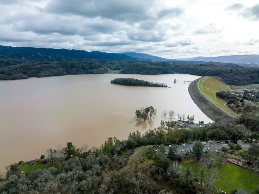
In December 2012, dam operators at Northern California’s Lake Mendocino watched as a series of intense winter storms bore down on them. The dam there is run by the U.S. Army Corps of Engineers’ San Francisco District, whose primary responsibility in the Russian River watershed is flood control. To make room in the reservoir for the expected deluge, the Army Corps released some 25,000 acre-feet of water downstream — enough to supply nearly 90,000 families for a year.

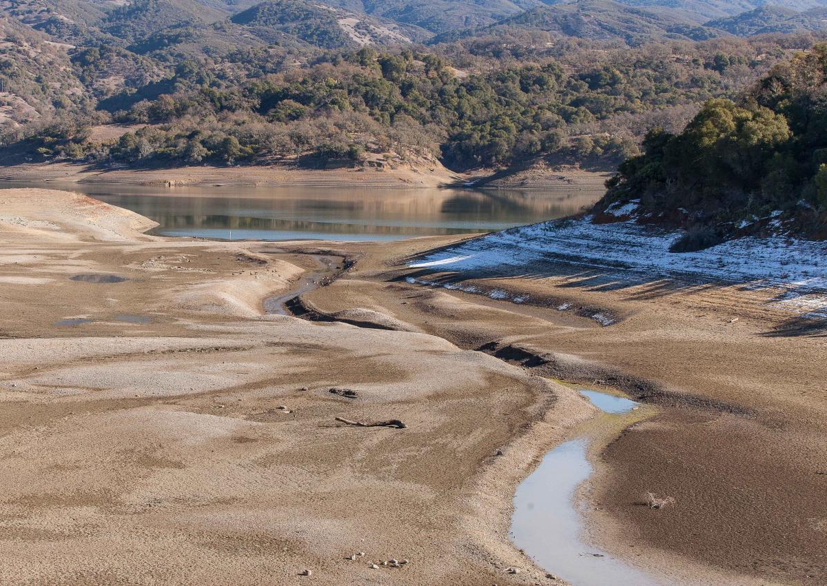
In doing so, the Army Corps averted the possibility of a catastrophic flood. But almost as soon as the water headed downstream, the pendulum swung in the other direction. The weather turned dry, and the months that followed proved to be the driest on record in California up to that point. A year later, the reservoir became a drought-cracked mudflat. The local water supplier, Sonoma County Water Agency, was forced to reduce releases by 60 percent during the dry summer, impacting urban and agricultural water users downstream.

State officials were frustrated. Members of a drought task force created by then-Gov. Jerry Brown traveled to Lake Mendocino, tucked into the coastal wine country near Ukiah, to hold a press conference. An exasperated John Laird, the state resources secretary at the time, asked some of the Army Corps’ top brass what they’d been thinking when they sent so much water downstream.

“I just blurted it out,” says Laird, now a state senator. “It was one of those emperor-has-no-clothes moments, because somehow nobody was speaking up about this.”

It made for an uncomfortable moment. But the incident catalyzed a wide-reaching effort to manage dams more nimbly in the face of wildly variable weather, and particularly to meet the challenge of atmospheric rivers — intense winter storms that pummel California and other parts of the West with huge amounts of rain.

In the wake of the controversy at Lake Mendocino, the quest to harness the power of atmospheric rivers birthed a new water-management approach: Forecast-Informed Reservoir Operations, or FIRO. The concept has been tested on three dams in California since 2019, with programs in development for several other dams across the West.

By pairing FIRO with accurate forecasts of where those storms will hit and how much rain they’ll bring, dam operators can work in real time to not only reduce the risk of dangerous floods, but also capitalize on atmospheric rivers’ potential as a source of additional water for protection from drought.

Now, the concept is poised to improve operations at 39 more dams across the arid Southwest and another 71 throughout the rest of the country. That will vastly increase FIRO’s potential and help dam operators stand ready for the wilder weather that the future will likely bring: storms intensified — and made more erratic — by climate change.

Some 50 atmospheric rivers hit the West Coast of the U.S. during the 2024-25 season. (Source: Center for Western Weather and Water Extremes)

Atmospheric Rivers Enter the Lexicon

For decades, the “Pineapple Express,” a type of storm that feeds off warm tropical moisture, figured prominently in local weather lore. By the early 1990s, researchers realized that it was just one kind of a broader category of unique storms that take shape far out in the Pacific. In a 1994 research paper, Yong Zhu, now at North Carolina State University, and MIT’s late Reginald Newell, christened them atmospheric rivers.

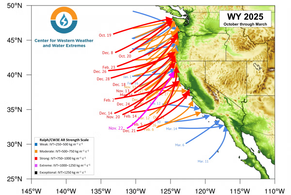
According to a 2019 study, atmospheric rivers caused $5.2 billion in damage in Sonoma County over the preceding two decades and were responsible for 99.8 percent of all insured flood losses there. A single 1995 storm — the most damaging event in 40 years of record keeping in the West — inundated the town of Guerneville on the Russian River and caused $50 million in insured losses countywide. The study determined that atmospheric rivers are the primary driver of flood damage in the West.

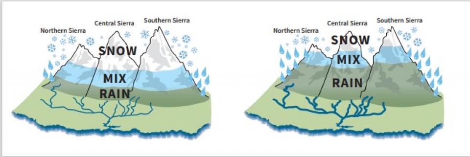
These powerful plumes of water vapor — which, on average, carry 25 times the flow of the Mississippi River — deliver 30 to 50 percent of total annual precipitation in California.

“Atmospheric rivers are the hurricanes for the West Coast,” says Cary Talbot, the FIRO National Lead with the Army Corps’ Engineer Research and Development Center.

But when they fail to arrive, that can also have a big impact, leaving the state parched and reeling. Their influence isn’t limited to just California, either: In 2021, researchers Mu Xiao, now at the Scripps Institution of Oceanography at UC San Diego, and Dennis Lettenmaier, now at University of California, Los Angeles found that almost one third of snowpack in the Upper Colorado River Basin comes from snowfall brought by atmospheric rivers.

The Army Corps’ primary responsibility is the high-stakes task of controlling floods, or as the agency puts it, “flood risk management.” As a result, the Army Corps tends to be extremely risk averse, and it literally runs its dams by the book: Each of its dams has an individually formulated water control manual with flood control curves, more commonly known as “rule curves,” that are practically chiseled in stone.

“When those things are written, they go through a really rigorous (vetting) process because it’s what we are going to be graded on in the courts,” says Talbot. “When somebody sues us for how we operated, they’re going to look at the water control manual and say: ‘Did the operators follow the rules?’ So, water managers don’t really want to stray too far from what it says.”

Rule curves typically force operators to keep reservoir levels low during wet seasons so they can catch and hold back the rainfall from anticipated storms and reduce the impacts of flooding downstream. But if those storms veer off their predicted course, or dissipate before they arrive, operators can’t get back the water they’ve already released — exactly what happened at Lake Mendocino in 2012.

The public outcry over that incident, which would be followed by the driest three-year period on record until then, helped nudge the Army Corps toward a more flexible approach.

Flood-control releases in December 2012, followed by months of drought, sent reservoir levels in Lake Mendocino — shown here in December 2013 — plummeting. (Source: Sonoma Water)

“The disaster of a really bad drought in California focused congressional attention,” says Talbot. In 2015, Congress added a line in the Army Corps’ budget for a research-led Water Operations Technical Support program. “It wasn’t much money — it was really just $2 million to get it started — but the direction from Congress was to see if we can’t find a better balance between flood risk management and water supply, especially with respect to atmospheric rivers.”

The following year, the Army Corps modified its regulations to allow for the use of forecasts in operations planning. Actually incorporating that change into each dam’s water control manual, many of which are decades old, still required an administrative process that typically takes several years. But the announcement was a significant first step in the shift away from the hidebound rule curves that governed dam operations.

To make it all work, though, dam operators had to have weather forecasts that they could trust.

Decoding Atmospheric Rivers

As it happened, weather researchers were already on a quest to crack the mystery of how atmospheric rivers work. A key figure in the effort was Marty Ralph, who spent more than two decades as an atmospheric scientist at the National Oceanic and Atmospheric Administration (NOAA) beginning in 1992.

Marty Ralph, head of the Center for Western Weather and Water Extremes (CW3E), worked with colleagues to vastly improve the accuracy of atmospheric river forecasts. (Source: CW3E)

Ralph had begun studying cyclones off the U.S. West Coast in the mid-1990s. To get an up-close view of the storms in their spawning grounds far out at sea, he wheedled and cajoled the use of weather research aircraft from NOAA, NASA and the Air Force that sat idle following the busy summer hurricane season on the Gulf Coast. (At one point, Ralph experimented with — but ultimately gave up on — using a long-range surveillance drone called the Global Hawk, an $80-million-plus “hand-me-down,” as he puts it, from the Air Force to NASA.)

Ralph’s research focus gradually zeroed in on what would turn out to be atmospheric rivers. He didn’t read Zhu and Newell’s groundbreaking work on the phenomenon until 2003, but when he did, “the light bulb just went off, like, ‘Oh — that’s what we’re studying!’”

Ralph organized a series of annual “field campaigns” to learn more about atmospheric rivers and racked up more and more flight time. In 2013, he left NOAA to start the Center for Western Weather and Water Extremes, or CW3E, at the Scripps Institution of Oceanography at UC San Diego. There, working with other researchers, he continued to research atmospheric rivers’ origins and behavior. But along the way, he says, “it became clear to me that we should be trying this as an operational program to help with forecasting” so that dam operators could have a more accurate real-time picture of individual storms’ paths and intensity.

Lake Becomes Proving Ground

Meanwhile, Lake Mendocino was emerging as the first test case for FIRO. At the time, Jay Jasperse was the chief engineer and director of groundwater management for Sonoma Water, which gets much of its supply from the lake. Despite the Army Corps’ new openness to using forecasts for more flexible dam operations, he says, there initially was “a lot of skepticism from some parties, and there was a lot of concern that the Army Corps was going to be incurring a lot of liability, and that this is going to negatively impact their flood risk management operations.”

During the 2020 water year, FIRO allowed an extra 19 percent, or 11,175 acre-feet of water, to be captured in Lake Mendocino. (Source: Sonoma Water)

“There were some spirited debates, and I think it took us a few years just to learn about each other and about each other’s agencies and how we worked and what our needs were,” Jasperse says. “But we all stuck with it, because the overall idea just made too much sense.”

Before FIRO was tried at Lake Mendocino, it went through an exhaustive modeling process to determine how it would affect dam operations. Gradually, Jasperse says, “we started seeing this was pretty doable, and the Army Corps started to get more comfortable with it.”

After extensive modeling, FIRO was first tested at Lake Mendocino during the 2020 water year and immediately proved its worth: That year, FIRO allowed an additional 11,175 acre-feet of water to be captured and stored there. That helped show that dams originally built principally for flood control could also be used to increase water storage and reliability.

“There’s ways to do both under the right conditions, and Lake Mendocino is proof of that,” says Patrick Sing, the lead water manager for the Army Corps’ San Francisco District. “When all the weather forecasts say it’s going to be dry, we can hold onto a lot of water instead of releasing it. We’re not impairing our flood management mission, and we’re doing our part to be stewards of a resource that’s very valuable in the event that the next year is a drought.”

Still, Sing notes that FIRO isn’t a silver bullet.

“You do all this research and modeling, but at the end of the day, it comes down to the reservoir operator to make a decision, and their agency is going to be held responsible for that decision,” he says. “If they’re not comfortable enough with FIRO, it’s probably not going to move forward. And they shouldn’t be forced to do it. They should be comfortable and convinced that it is safe to do.”

At Lake Mendocino, Sing says, “there’s been enough research and development and testing that we’re comfortable doing this.”

Forecast-Informed Reservoir Operations are currently underway or being actively assessed at 21 dams on the West Coast. (Source: U.S. Army Corps of Engineers)

Expanding FIRO

In 2022, FIRO-based operations were extended to Lake Sonoma, the other reservoir that supplies Sonoma Water within the Russian River watershed. And this year, FIRO was put in place on a preliminary basis at another dam, Prado Dam on the Santa Ana River in Southern California. Since 2020, FIRO has contributed to an additional 95,000 acre-feet of storage in the three reservoirs — an amount equal to just over 75 percent of Lake Mendocino’s total volume.

“We’re getting better and better,” says Jasperse, who now works as a consultant for both Sonoma Water and CW3E. “Everybody’s getting more and more experience every year.”

FIRO won’t work at all dams, especially in areas where forecasts are less reliable. In the summertime in the Deep South, for example, “pop-up thunderstorms can happen any day, any time,” says the Army Corps’ Talbot, who is based in Mississippi. “We’ve got a lot of moisture coming up from the Gulf, so it’s much harder to predict that kind of impactful rain here than it is in the West.”  

But experience has shown that where FIRO is viable, it can provide additional water at a cost far lower than traditional approaches for boosting water supply, like increasing the size of a dam.

“Those are lengthy, expensive and complicated processes. It’ll take, in some cases, a decade or more to realize those benefits,” says Talbot. “FIRO is something that we literally can do today. We didn’t have to change the dam at all. This is just taking existing infrastructure and making it work better.”

At Prado Dam in Southern California, the Orange County Water District is expanding the possibilities of FIRO by pairing it with a groundwater recharge program to ensure that water that’s released from the dam isn’t lost. There, releases can be diverted into recharge basins downstream, where the water then soaks into the local aquifer.

Adam Hutchinson, the district’s recharge planning manager, says the agency anticipates getting an average of an extra 6,000 acre-feet per year through its FIRO operations. That’s not a lot of water, but it makes a big difference. The water retailers in the district’s service area rely on groundwater for the majority of their water supply, but they still have to import about 15 percent from Northern California and the Colorado River, at a cost of more than $1,000 per acre foot.

“So for that 6,000 acre-feet that we hope to get,” he says, “that’s $6 million a year that we’re saving by putting this free water in the ground.”

“AR Recon” flights to improve the accuracy of atmospheric river forecasts, which have been carried out from California and Hawaii for years, are now also being launched from Guam and Japan. (Source: U.S. Air Force 403rd Wing)

More Dams on the Radar 

While FIRO is currently in place at just three dams, it is on the brink of a dramatic expansion. Earlier this year, two more dams — both significantly larger than any at which FIRO is currently in place — were added to the roster of potential FIRO sites: The Yuba Water Agency’s New Bullards Bar on the Yuba River, and Lake Oroville, the 3.5-million-acre-foot flagship of the State Water Project on the Feather River. A group of federal and state agencies and CW3E completed a final viability assessment at the two dams. The California Department of Water Resources and Yuba Water are now contemplating what steps to take to put FIRO into practice at those facilities. (In 2019 a more limited program, often referred to as “FIRO Lite,” went into operation at the federal Bureau of Reclamation’s Folsom Dam, on the American River just upstream of Sacramento.)

FIRO-implementation efforts are also in progress for several other dams: Seven Oaks, upstream of Prado on the Santa Ana River; a system of 14 dams in Oregon’s Willamette Valley; and Howard Hanson Dam near Seattle.

And now, FIRO is about to get a much bigger boost. In May, the Army Corps completed an initial evaluation of the suitability of FIRO at each of the 593 flood-control dams under its authority nationwide. It found that implementing FIRO is promising at 110 of those, including 39 across the Southwest. Another 299 dams nationwide may have potential as candidates for FIRO, although they face some significant barriers to implementation.

The Army Corps is now moving forward on two more-detailed rounds of evaluation on the 110 top-tier dams. Then, beginning in 2027, it will move toward implementing FIRO at those with the most potential.

The biggest impediment to more widespread implementation of FIRO remains a lack of accurate forecasts in parts of the country that don’t experience atmospheric rivers.

“The most common reason it’s not going to work is forecast skill” — essentially, accuracy, says Talbot. “That’s the leading factor for eliminating dams in the screening process.”

In the West, the effort to improve forecasts only continues to advance. In December 2023, then-President Biden signed the Atmospheric River Reconnaissance, Observations and Warning Act, which had been introduced by California’s senior U.S. senator, Alex Padilla. The law called for what has become known as the AR Recon aerial surveillance program, led by Ralph and Vijay Tallapragada of the National Weather Service, to be expanded throughout the full winter season. The past two years, AR Recon carried out 107 reconnaissance flights across the Pacific, flying not only out of California and Hawaii, but Guam and Japan, as well.  

“The farther West we go, the greater the lead time improvement we get” in forecasting, says Ralph. “We’ve been able to improve the forecast of extreme precipitation in California by about 12 percent just by adding the (AR Recon) data. That’s the equivalent of 10 years of the typical process of improving forecasts through research — so we’re buying a decade of advances just by adding these data.”

The Army Corps’ Talbot says those strides forward are welcome news for dam operators.

“If you take a water manager and you give them three extra days of lead time, they can do a lot with that. Water managers always tell me, ‘Look, you give me a weather crystal ball and I’ll manage water better,’” he says.

“As long as we keep the aircraft flying and people advancing on the science and the meteorological wizardry, these water managers are getting closer and closer to that crystal ball.”


Reach Writer Matt Jenkins at mjenkins@watereducation.org

Know someone who wants to stay connected to water in the West? Encourage them to sign up for Western Water and follow us on LinkedInX (formerly Twitter)Facebook and Instagram.

Changes Loom for Innovative Lower #ColoradoRiver Endangered Species Program Amid #Drought, New River Rules — Matt Jenkins (Water Education Foundation)

Endangered bonytail chub were released into a Colorado River lagoon south of Laughlin, Nev., in spring of 2024 as part of the MSCP. (Source: Bureau of Reclamation)

Click the link to read the article on the Water Education Foundation website (Matt Jenkins):

April 17, 2025

WESTERN WATER IN-DEPTH: As the 50-year Multi-Species Conservation Program hits the 20-year mark this month, new questions about how to keep it strong hang over its future

Before the construction of Hoover Dam on the lower Colorado River, as well as a slew of smaller sisters downstream, the stretch downriver served as a biological oasis in the middle of the unrelenting Mojave and Sonoran deserts. The marshes and backwaters along the river’s edge provided sheltered areas for fish to spawn and rear their young, and mesquite and cottonwood-willow forests provided important habitat for numerous species of birds and other animals. But when Lake Mead began filling behind Hoover Dam in 1935, it drastically reduced the amount of water flowing downstream, radically altering the habitat there.

In the decades that followed, the river flow captured by Hoover Dam became a critical source of water for farms and cities across Southern California, Nevada and Arizona – transforming deserts into some of the nation’s most productive farmland and creating some of the most populous cities such as Los Angeles, Phoenix and Las Vegas. Today, more than 27 million people in the three states rely on water from the Colorado River—roughly two-thirds of the total population that the river serves. Yet even as that dependence on the river grew, a collision between human and environmental needs was brewing.  

Historically, the Colorado River was home to more than 30 mostly endemic native fish species. In 1967, a native fish called the pikeminnow and another called the humpback chub were classified as endangered under federal law. They were the first of what are known as the four “big river” fish species to be added to the endangered species list. Thirteen years later, in 1980, came the bonytail chub. Then, in 1991, came the fourth – the razorback sucker. (An endemic bird called the Yuma clapper rail had also been classified as endangered in 1967.)

For municipal and agricultural water managers who depended on the Colorado, the growing list of endangered species was a wakeup call. It spurred a decade-long effort to craft a multi-party agreement that allowed water agencies to continue delivering water to their users while staying ahead of the mounting endangered species issues. That effort has largely proven successful, but as the program now crosses the 20-year mark, new questions are arising about how to keep it strong for the next three decades in the face of grinding drought, contentious negotiations over the river’s future, and new uncertainties about the federal government’s role in its continued implementation.

A New Approach on Habitat

In November 1994, the federal Bureau of Reclamation, which operates the big Colorado River dams and makes water deliveries, agreed to work together with state and local agencies to mitigate the effects of water and power operations on threatened and endangered species. The effort didn’t come a moment too soon: Four months later, another species — a bird called the southwestern willow flycatcher — was also declared endangered.

“When the big-river fishes were listed, it was a kick in the pants for folks along the river to put together something broad enough to anticipate most of what’s going to happen in the next 50 years,” said Jessica Neuwerth, the executive director of the Colorado River Board of California, which represents the state’s agricultural and urban users of the river’s water. “Then the southwestern willow flycatcher kicked it into overdrive.”

As it happened, a new approach had recently appeared on the horizon that focused on restoring and protecting habitat not just for individual endangered species, but for a broad range of them existing in a particular region. Long-term, large-scale “multispecies habitat conservation plans” were taking shape in a variety of places, including California’s San Diego County, southwestern Riverside County and the Coachella Valley.

The four so-called big river fish, from top: razorback sucker, Colorado pikeminnow, bonytail chub and humpback chub. (Source: U.S. Fish and Wildlife Service)

The new approach was championed by Bruce Babbitt, the former governor of Arizona who, at the time, was Interior secretary under Bill Clinton. “Babbitt was a big advocate for this style of landscape-level species and habitat management,” said Chris Harris, who preceded Neuwerth at California’s Colorado River Board and was involved in the early discussions. “And he really urged all of us to keep our noses to the grindstone and put something together that could work.”

The effort to create a broad habitat conservation program for the Lower Colorado dragged on for a decade. But it quickly became clear that all the participants would be better off if they tackled the endangered species issue together. Finally, in April 2005, the federal government and non-federal participants signed an agreement that officially launched the Lower Colorado River Multi-Species Conservation Program. Under it, the Bureau of Reclamation, irrigation districts and municipal water agencies committed to a 50-year, $626 million inflation-adjusted program, splitting the cost evenly between the federal government and state parties.

The Lower Colorado River MSCP “is unique in a lot of ways — partly because it is a federal and non-federal program, where we really haven’t even tried necessarily to disentangle whose impact is whose,” said Neuwerth. “There’s so much overlap between what the feds do and what the state or local agencies do that we really are bound together. We’ve blended both the non-federal and federal compliance into one package, and it’s more efficient than everybody going off and doing their own thing.”

Managed by the Bureau of Reclamation, the program pledged to create 512 acres of marsh and 360 acres of backwaters — habitat for Colorado River native fish — as well as 1,320 acres of mesquite woodland and 5,940 acres of cottonwood-willow forest along the river for the imperiled birds. In addition, the program would pay for rearing and stocking more than 660,000 razorback suckers and 620,000 bonytail; fund ongoing maintenance of the newly created habitat; and carry out monitoring and research to adaptively manage restoration efforts based on an 

Intended to last over the long term, the MSCP was also designed to be flexible. “That’s always been the goal,” said Neuwerth, “to be proactive and make sure that we have this umbrella that’s going to protect us for a pretty wide range of future conditions.”

Seth Shanahan, Colorado River Program Manager for the Southern Nevada Water Authority. (Source: Water Education Foundation)

The program was not designed to recover endangered species populations. But it was, at its root, an insurance program to protect Lower Basin water users and the federal government against potential violations of the Endangered Species Act, or ESA, as they continued their primary mission of delivering water to cities and farms.

“We couldn’t do what we do on a day-to-day basis without this program,” said Seth Shanahan, the Colorado River Program Manager for the Southern Nevada Water Authority (SNWA), which supplies water to the Las Vegas metropolitan area. He noted that water agencies are dependent on the Bureau of Reclamation’s ability to store water in Lake Mead and deliver it downstream, as well as to develop plans for when to take shortages and how to share water among themselves to lessen the impacts of drought. “All of that is enabled by the MSCP.”

Helping Species Survive and Thrive

In contrast to an endangered-species recovery program, the MSCP isn’t explicitly intended to increase endangered species populations to the point that they can be taken off the endangered species list, or their protection status at least downgraded. 

“MSCP is a habitat creation program,” said Vineetha Kartha, Colorado River programs manager for the Central Arizona Project (CAP), which transports river water to Phoenix, Tucson, farms and tribes. “We are creating habitat so that species thrive and can still survive under these changed circumstances.”

Twenty years in, the program has already created roughly 75 percent of the habitat it initially pledged to take on.

“We’re trying to do the best we can with what is available,” said SNWA’s Shanahan. “Restoring the functionality of habitat for species is the important part, not necessarily (restoring) it to what was there 500 years ago.”

Workers plant seedlings of cottonwoods, willows and mesquite trees at an MSCP habitat restoration project south of Blythe, California. (Source: Bureau of Reclamation)

MSCP’s adaptive management, or adjust-as-you-go, approach has helped it adapt to changing conditions and a constantly improving understanding of how to meet the needs of individual species. “Folks early on realized they didn’t know everything. So they gave us an opportunity to modify the course as we learn more information, and that’s really useful,” Shanahan said. “We need to have some space to try different things and see what works.”

One important part of the program focuses on stocking hatchery-raised razorback suckers and bonytail into their native habitat below Hoover Dam. But because the natural system has been so drastically altered, ensuring their survival hasn’t been easy.

“It’s a tough hand of cards for native fish in this part of the world,” said Neuwerth, an environmental scientist by training. “We have dams, we have diversions, we have introduced fish, and there’s really no way of turning that clock back. We’re doing the best we can with the system as it is, and we’re trying out new stuff all the time. Anything that can give our fish an edge, we’ve looked at it.”

Giving native fish — which are raised in hatcheries as far away as eastern New Mexico — that edge has gone as far as running “fish survival camps” to teach them the kind of street smarts they need to survive in the modern-day river. At one point, fisheries biologists even used Botox injections to paralyze the jaws of non-native fish and then released them, along with a dose of predator-alarm pheromones, into ponds filled with razorback suckers and bonytail chub to teach them how to recognize and avoid predators.

Outside-the-box experimentation like that has been just one of the ways the MSCP has been able to adapt to changing realities on the river.

Humpback chub swim in the waters of the Lower Colorado River. (Source: Bureau of Reclamation)

“We always knew that what we were doing was not going to be the be-all, end-all, for the full 50-year term,” Harris said. To accommodate unanticipated events such as the discovery of new protected species within the MSCP project area, the program’s creators adopted what he called a “plug and play” approach.

In 2015, biologists discovered the presence of the threatened Northern Mexican gartersnake upstream of Lake Havasu, a key reservoir for Southern California and Arizona, possibly drawn in by habitat improvements made under the MSCP.

“That wasn’t on our list (in 2005) but then became threatened, and it was found within our program area,” said SNWA’s Shanahan. “So we also had to go back and consult on the impacts to that species. But there were mechanisms in the permits that allowed us to do that pretty efficiently.”

‘A String of Pearls’

The heart of the MSCP is its commitment to create conservation areas that provide the marshes, backwaters and riverside forest on which endangered species depend. One of the MSCP conservation areas lies on tribal land of the Fort Yuma Quechan Indian Tribe

“The tribe had a strong interest in pursuing a project that would reconnect the tribal people and the larger community back to the river,” said Brian Golding, Sr., the Quechan tribe’s economic development director. As dams, levees and irrigation projects were developed, “the river was forgotten. Anything on the river side of the levees essentially became overgrown and invaded by invasive species and became a no-man’s land.”

Lower Colorado River Multi-Species Conservation Program

Since 2005, the Lower Colorado River Multi-Species Conservation Program has grown to include 18 habitat conservation areas along the river. The map below highlights the six stretches of the river with MSCP-managed habitat.


In 2004 the tribe, in partnership with the Yuma Crossing National Heritage Area, the city of Yuma and the Arizona Game and Fish Department, began restoring wetlands on the tribe’s reservation along the Colorado River, creating a mosaic of marshes and stands of mesquite, cottonwood and willow that benefit an array of endangered species. In 2013, the tribe finalized an agreement with the MSCP to include the 380-acre Yuma East Wetlands within the program in exchange for operation and maintenance funding over 50 years.

That has helped the tribe develop its own ability to restore and maintain natural habitat along the river. Today, six members of the tribe work on habitat restoration and maintenance, along with a tribe member-owned contracting company, and Golding said the tribe is in talks with the MSCP program to restore another 30 to 40 acres of wetlands along the river.

The Yuma East Wetlands are just one piece of the bigger network of conservation areas, which has grown to 18 sites between Hoover Dam and the Mexican border.

When the MSCP first started, “I think people thought this was just a Band-Aid and duct tape approach,” said Harris. “Now, these conservation areas are really a string of pearls, and they’re all sort of connected together. Every few miles, there’s a huge patch of native riparian marsh and aquatic habitat that’s being managed by the program so the species can travel up and down the riverine corridor – whether they’re birds or fish or terrestrial species – and have these areas of safe haven.”

Although the MSCP is a stand-alone program, it’s ecologically linked with an ambitious restoration effort taking place across the border in Mexico. There, a coalition of non-governmental organizations including National Audubon Society, Restauremos el Colorado, the Sonoran Institute and Pronatura have been working to restore portions of the Colorado River Delta. “Many of the ideas and techniques that have been developed and utilized in the MSCP have now been applied in the Mexican restoration program,” Harris said, “so there’s been a lot of carryover and cross pollination from work done under the MSCP down to the environmental program in Mexico.”

The Hart Mine Marsh was initially created by historic flood flows from the Colorado River, but as the river system changed, including from water operations, the marsh deteriorated. Reconstruction of the marsh is among the habitat projects undertaken through the MSCP. (Source: Bureau of Reclamation)

Ecologically, both those efforts also tie together with the ongoing initiative to restore habitat at the Salton Sea, Harris said. “If you can link those three areas,” he said, “you’ve got a pretty good mosaic now from Lake Mead downstream all the way to the Gulf of California.”

Julia Morton, Audubon’s Colorado River program manager, said MSCP’s comprehensive approach and its rigorous scientific monitoring program can help improve conditions not just for the species it’s specifically designed to protect, but for the entire ecosystem along the lower reaches of the river. “That’s a huge improvement over ‘one-off’ mitigation projects,” she said.

In late April, the MSCP’s steering committee will vote on a request by Audubon to join the committee — a move that would only strengthen the synergy between the U.S and Mexican restoration efforts. “The frameworks and the driving forces of each program are pretty different,” said Morton, “but at the end of the day, these programs are both creating quality habitat.”

The Catch-22 of Historic Drought

Those efforts seem to be yielding positive results. In 2021, for instance, the humpback chub was “down listed” from endangered to threatened. But along the way, the MSCP has been forced to contend with a number of unanticipated challenges – especially drought.

“A lot of thought was put into MSCP,” said CAP’s Kartha. But when the program was designed, “we didn’t understand how bad the hydrologies could tank.”

Vineetha Kartha, Colorado River programs manager for the Central Arizona Project. (Source: Central Arizona Project)

When the MSCP was officially launched in 2005, the Colorado River Basin was already five years into a major drought, which has only gotten worse in the years since. The drought is now dragging into its 25th year, and studies suggest that it could be the worst drought on the river in the past 1,200 years.

“Hydrology has been our biggest surprise so far,” said Kartha. “And basically, we have had to move with the times.”

In 2019, the seven Colorado River states and the federal government agreed to a pair of “drought contingency plans” to save water and store it in lakes Mead and Powell, the river’s two largest reservoirs. In 2024, the Lower Basin states agreed to a follow-on plan to conserve an additional 3 million acre-feet over three years and store that in Lake Mead. Those actions helped the states prop up their water supply, but that also meant somewhere around 1.7 million acre-feet less water was released from Hoover Dam per year.

Those efforts to weather the drought have revealed a Catch-22. For decades, water use contributed to the decline in the river’s native species. Now, though, using less water potentially harms the environment, because as that conserved water is stored in Lake Mead, less water flows down the lower Colorado River, potentially amplifying damage to habitat.  

“We are in this strange paradox where folks doing the right thing for the system and leaving water behind (in Lake Mead) could potentially have an impact on the river channel,” Neuwerth said. “So we’re balancing those two things and trying to avoid getting caught in a situation where we’re penalized for saving water.”

The 2019 and 2024 drought-protection strategies forced the Bureau of Reclamation to initiate two rounds of “reconsultation,” a process under which the U.S. Fish and Wildlife Service reviews any new federal actions that may harm endangered species or their habitat. In response, the Fish and Wildlife Service issued a pair of biological opinions that required the MSCP to create another 180 acres of marsh and backwater habitat to offset the potential loss of habitat caused by the reduced flows.

Uncertain Future Federal Role  

Questions about water availability, funding and regulatory oversight may only sharpen in the future. The change in presidential administration earlier this year has already raised uncertainty about the federal government’s role going forward.

In March, the Bureau of Reclamation declined comment for this story “due to our on-going mission requirements, the increased workload to accommodate the new administration’s priorities and awaiting the appointment of the new Reclamation Commissioner and their direction.” The U.S. Fish and Wildlife Service also declined comment, using nearly identical language.

The lowland leopard frog, one of the species covered by the MSCP. (Source: Bureau of Reclamation)

It’s indisputable that the federal government has played a critical role in the success of the MSCP — and its role in assuring reliable water supplies for some 27 million people in the river’s Lower Basin states.

“When (the non-federal participants) were originally talking about putting together the program, they were considering whether to hire a third party to do the work. But instead, we have Reclamation as the implementing agency, and their workers are the ones that build the habitats and maintain them,” said Neuwerth. “That’s really helped us keep the cost down. And I think it just makes a lot of sense to have one of the parties to the MSCP responsible for the actual on-the-ground work.”

The Trump administration has already signaled its intent to rescind at least parts of both the Endangered Species Act (ESA) and the National Environmental Policy Act (NEPA). On April 16, it proposed a rule that would strip federal protections for habitat needed by threatened and endangered species to survive. Fully repealing the ESA and NEPA would take an act of Congress, but if that were to happen it would gut the primary drivers behind the creation of the MSCP.

Yet even if federal environmental and endangered species-protection laws were gutted, California’s Endangered Species and Environmental Quality acts (known as CESA and CEQA) — which are even more stringent than their federal equivalents — would almost certainly remain in place.

Under California law, “the California permittees have made certain commitments. If there was no more ESA and there was no more MSCP, those commitments would still exist,” said Neuwerth. “It’s tough to know exactly how it would all shake out, but I think CESA and CEQA provide a backstop in California that wouldn’t go away if the MSCP did.”

The Southwestern willow flycatcher, listed as an endangered species by the U.S. Fish and Wildlife Service. (Source: USFWS)

While Arizona and Nevada aren’t subject to similar state requirements, they may not be willing to step away from the program, either. Water agencies would face tremendous uncertainty in their long-term planning with a federal abandonment of the ESA and NEPA and the drawn-out legal challenges sure to follow — to say nothing of the fact that the MSCP, as originally agreed to by the participants, would still have a quarter-century left to run after the end of the current presidential administration. 

“With the agreements we have in place, I don’t know that it would be all that easy for any administration to reel that back,” Harris said. “This program works, and it works well. It gives the feds what they need to be able to optimize their management flexibility for the entire Colorado River system — and particularly from Glen Canyon Dam downstream. And from a federal perspective, I think that’s got to be hugely important.”

“Having that environmental regulatory compliance package in place,” he added, “gives all the stakeholders — whether it’s the agricultural water users, the municipal water users or the federal agencies operating the system — a pretty significant measure of reliability and certainty for future operations.”

Regardless of what happens on the regulatory front, the MSCP’s participants are already contemplating potential big changes in how the Colorado River will be managed over roughly the next two decades. The current set of guidelines governing Colorado River operations expires next year, so states and the federal government are scrambling to agree on a new set of post-2026 operating guidelines.

That negotiation has proven particularly contentious and nearly broke down last year, so it’s far from clear what the final guidelines might look like — but they are nearly certain to include at least an additional 1 million acre-foot per year reduction in river flows below Hoover Dam. Regardless of what the exact numbers are, the MSCP’s steering committee is already anticipating the need to initiate a third, much more significant round of reconsultation with the U.S. Fish and Wildlife Service. 

Sunrise at the Laguna Division Conservation Area near Yuma, Arizona, where Reclamation has worked on riparian and marsh restoration as part of the Lower Colorado River MSCP. (Source: Bureau of Reclamation)

The 2022 and 2024 biological opinions gave MSCP participants “a pretty wide band of coverage” through 2028, but “that’s sort of a short-term patch,” said Neuwerth.

“We’d like to make sure that the umbrella going forward is big enough to cover us through 2055, so that requires a little bit of crystal-ball reading of what could be coming down the line,” she said. “We’re also struggling with the effects of climate change reducing the amount of water that’s available, and what does it look like for a recovery program to navigate through that?”

Despite the uncertainty over the program’s future, Neuwerth said the MSCP has already proven its worth. “We’ve seen over the past 20 years that we’re all pulling in the same direction.”

Now, at a time when tensions over future operations on the Colorado River are exceptionally high, MSCP “has provided us a lot of certainty, and it’s allowed us breathing room to do things like (water conservation and drought management) without having to scramble to put together compliance every time something new is happening on the river,” she said. “That’s really helped provide stability on the Lower Colorado River, and it’s one less thing to fight over if we’re making changes.”


Matt Jenkins. Photo credit: Water Education Foundation

Reach Writer Matt Jenkins at mjenkins@watereducation.org

Know someone who wants to stay connected to water in the West? Encourage them to sign up for Western Water and follow us on LinkedInX (formerly Twitter)Facebook and Instagram.

As #ColoradoRiver flows drop and tensions rise, #water interests struggle to find solutions that all can accept — Water Education Foundation #COriver #aridification #CRWUA2022

Hoover Dam’s intake towers protrude from the surface of Lake Mead near Las Vegas, where water levels have dropped to record lows amid a 22-year drought. (Source: Bureau of Reclamation)

Click the link to read the article on the Water Education Foundation website (Nick Cahill):

Chorus of experts warn climate change has rendered old assumptions outdated about what the Colorado River can provide, leaving painful water cuts as the only way forward

When the Colorado River Compact was signed 100 years ago, the negotiators for seven Western states bet that the river they were dividing would have ample water to meet everyone’s needs – even those not seated around the table.

A century later, it’s clear the water they bet on is not there. More than two decades of drought, lake evaporation and overuse of water have nearly drained the river’s two anchor reservoirs, Lake Powell on the Arizona-Utah border and Lake Mead near Las Vegas. Climate change is rendering the basin drier, shrinking spring runoff that’s vital for river flows, farms, tribes and cities across the basin – and essential for refilling reservoirs.

The states that endorsed the Colorado River Compact in 1922 – and the tribes and nation of Mexico that were excluded from the table – are now straining to find, and perhaps more importantly accept, solutions on a river that may offer just half of the water that the Compact assumed would be available. And not only are solutions not coming easily, the relationships essential for compromise are getting more frayed.

With the Compact’s shortcomings and the effects of climate change and aridification becoming as clear as the bathtub ring around Lake Mead, previous assumptions of how much water the river can provide and the rules governing how it gets divvyed up must be revised to reflect the West’s new hydrology. One thing is certain among experts and Colorado River veterans: Water cuts are in the short-term and long-term forecast for major cities such as Los Angeles, Las Vegas and Phoenix, as well as farmers from Colorado’s West Slope to growers in California’s Imperial Valley near the Mexican border.

“You don’t have any other arrow in your quiver right now except to reduce use,” Pat Mulroy, former general manager of the Southern Nevada Water Authority, told a gathering of Colorado River water interests this fall. “There are no other arrows.”

Updated Colorado River 4-Panel plot thru Water Year 2022 showing reservoirs, flows, temperatures and precipitation. All trends are in the wrong direction. Since original 2017 plot, conditions have deteriorated significantly. Brad Udall via Twitter: https://twitter.com/bradudall/status/1593316262041436160

The River’s Changing Math 

Predicting the amount of water the Colorado River can provide in a given year has always been a challenge. The river’s flow is famously erratic, dictated by the size of the often-fickle Rocky Mountain snowpack and other variables such as soil moisture and changes in temperature. 

Flows in the White River (pictured above) and other Upper Basin tributaries have declined dramatically over the last 20 years, a trend experts warn will worsen as the West becomes hotter and drier. (Source: The Water Desk)

The old expectations of the Compact signers is giving way to a new reality on the river. Over the last century, the river’s flows in the Upper Basin have dropped by 20 percent. Scientists have pinned warming temperatures as the main cause of the disappearing flows and predict the trend will worsen as the Upper Basin, source of most of the river’s water, becomes even hotter and drier. 

Water users have been able to counter previous dry spells by relying on the river’s main reservoirs. But after more than two decades of drought, both Lake Mead and Lake Powell are only about one-quarter full. The reservoirs’ rapid declines have forced the Bureau of Reclamation to order unprecedented water cuts to Arizona and Nevada. Mexico is taking similar cuts under binational agreements. And Reclamation has warned more severe actions are needed to prevent the collapse of the Colorado River system. 

The Compact signatories, relying on data from a small but abnormally wet time period, estimated the river’s annual average natural flow in the Upper Basin to be about 18 million acre-feet. The figure, they asserted, was enough to cover 7.5 million acre-feet of water in perpetuity for the Upper Basin states of Colorado, New Mexico, Utah and Wyoming, and 7.5 million acre-feet for the Lower Basin states of Arizona, Nevada and California. They also agreed that any water committed to Mexico would be supplied equally by the two Basins. Native American tribes, who now legally hold substantial rights to the river’s water, were barely mentioned.

Brad Udall, Colorado State University climate researcher, said it’s becoming harder and harder for the river to meet the promises outlined in the Compact and the accompanying set of agreements, laws and court cases referred to as the Law of the River. He warned dozens of water managers and policy experts at a recent Water Education Foundation Symposium that climate change caused by greenhouse gas emissions is rapidly and permanently shifting precipitation trends in the Basin.

“It’s not a drought, it’s not temporary, it’s aridification,” said Udall. “Additional 1 degree Celsius or more warming by 2050, Lee Ferry flows in 9 million acre-feet are possible. Every important trend line [is] heading in the wrong direction, notably our reservoirs, but all the science trends as well.” [ed. emphasis mine]

Data from recent decades shows it’s becoming uncommon for the river to meet the benchmark used to craft the Compact. Estimated annual flows at Lee Ferry, a key dividing point between the Colorado River’s Upper and Lower Basins, have surpassed 18 million acre-feet just four times since 1991, while the river’s average flow since 2000 has been 12.3 million acre-feet.

“If we’re taking out more than comes in, it is really simple math that the reservoirs are going to continue to decline,” said Rebecca Mitchell, director of the Colorado Water Conservation Board, the state’s water management agency. 

The federal government may reduce releases from Glen Canyon Dam (pictured above) in 2023 by an unprecedented 2-3 million acre-feet, a move that would trigger severe cuts in the Lower Basin. (Source: Bureau of Reclamation)

Mitchell was among nearly 200 state and regional water managers, farmers, tribal leaders and other water interests from the seven Basin states, along with key federal and Mexican officials, who attended the Foundation’s biennial Colorado River Symposium in late September to mark the Compact’s 100th anniversary and to discuss the risks and challenges ahead for the iconic Southwestern river. 

Discussions were sometimes sobering and sometimes tense, underscoring the growing risks to a river depended upon for drinking water by 40 million people and for irrigation of more than 4 million farmland acres across the Basin. An undercurrent of the discussions was whether Basin interests can avoid taking their differences to court – a prime motivation behind creating the 1922 Compact. Despite the occasional sharply worded airing of differences between Upper and Lower Basin interests, there was broad acknowledgement that action is needed to keep the river system functioning. 

Reclamation Commissioner Camille Calimlim Touton was among those urging water interests throughout the Basin to continue working collaboratively toward solutions and she provided a broad outline of actions that federal officials are preparing to take in 2023 – including reducing water releases from Lake Powell and Lake Mead – to keep the river from crashing. 

“The actions we choose to take over the next two years,” Touton told participants, “will define the fate of the Colorado River for the next century.”

Living Within New Means

Though the Colorado River’s annual yield has shrunk in the 21st century, demand for its diminishing supply hasn’t, creating a glaring math problem for Basin water managers. In a system where every drop of water is already allocated, the specter of an 11 million acre-foot river — or worse — is forcing users to prepare for a drier future. 

The Colorado River Compact divided the basin into an upper and lower half, with each having the right to develop and use 7.5 million acre-feet of river water annually. (Source: U.S. Geological Survey via The Water Education Foundation)

One agency that has been actively finding ways to stretch its river supply is Southern Nevada Water Authority, which serves more than 2 million people in the Las Vegas area. The agency has updated its modeling and long-range planning to reflect the river’s changing hydrology. 

John Entsminger, the authority’s general manager, said computer models are sending a direct warning that the Lower Basin will end up with only a slice of the 7.5 million acre-feet per year outlined in the Compact. After accounting for evaporation and system losses, he said, it’s probable the Lower Basin and Mexico will have much less water to split.

“It is incumbent upon the Lower Basin to come up with a plan to live within its 7 million acre-feet release from Lake Powell probably forever going forward and hope it’s not less than that,” said Entsminger.

Like Nevada, Arizona is already feeling the pinch from the latest round of federal water cuts. So far, the two states and Mexico have shouldered most of the pain.

In 2022, Arizona is using approximately 2 million of its 2.8 million acre-feet Colorado River allocation, according to state officials The state’s agricultural industry is taking the hardest hit, including one rural county that fallowed more than 50 percent of its farmland for lack of irrigation water.  

“We’re already seeing huge pain, and with an 11 million acre-feet [river] that pain’s just going to continue to grow,” said Tom Buschatzke, Arizona Department of Water Resources director. 

Lees Ferry, located 15 miles downstream of Glen Canyon Dam is the dividing line between the upper and lower Colorado River basins. Photo/Allen Best

The widening gap between supply and demand is also having an impact above Lee Ferry, where inflows into Lake Powell continue to fall below historical average. Water from Powell is critical for helping the Upper Basin meet its commitment under the 1922 Compact to deliver water to the Lower Basin.

Representatives from the Upper Basin states say they have collectively cut their annual consumptive river use from 4.5 million acre-feet to approximately 3.5 million acre-feet over the last three years. Over the same period, they argue, the Lower Basin has done little to reduce its own consumptive use. Similar to Arizona, Upper Basin farmers also have been on the receiving end of water cuts. 

The Ute Mountain Ute Tribe has fallowed the majority of its farmland in southwestern Colorado while in Wyoming, more than 100,000 acres of farmland were cut off from surface water for most of August because of low stream flows in the Upper Basin. 

“That equates to about 100,000 acre-feet of [diverted Colorado River water] a month…that’s a third of our average irrigated use,” said Brandon Gebhart, Wyoming State Engineer. 

The Upper Basin states have proposed a five-point plan built around paying farmers to reduce water consumption. Though it doesn’t require mandatory cuts for water users, proponents say the success of the plan hinges on whether the Lower Basin agrees to leave more water in Lake Mead.

“I think we need to recognize that the uses are far outweighing what Mother Nature is providing and that is primarily not in the Upper Basin,” said Mitchell with the Colorado Water Conservation Board. 

California In the Spotlight

California’s use of the river has been a sore point among others in the Colorado River Basin. California, the largest user of Colorado River water, has been spared from water cuts so far due to its senior priority rights and has been using its full 4.4 million acre-feet entitlement in 2022. Groups in both the Upper and Lower Basins say the state must significantly reduce its use to prevent the river system’s collapse.

The Salton Sea (pictured above ) straddles the Imperial and Coachella valleys and has long been a sticking point in Colorado River deals. But the federal government recently committed up to $250 million for restoration efforts at the sea. (Source: Water Education Foundation)

California water agencies and state officials have pushed back on criticism that they aren’t doing enough to help buoy the shrinking reservoirs.

Peter Nelson, chairman of the Colorado River Board of California, argued California delayed the current crisis by enacting voluntary deals that pay farmers not to plant their fields, transfer water to urban users or make their systems more water efficient.

“In the Lower Basin, since the last seven years or so, we’ve stored 1.5 million acre-feet of water in Lake Mead as Intentionally Created Surplus water,” said Nelson, who farms in the Coachella Valley. “That has enabled the lake levels at Lake Mead to stay high enough to stay out of shortages and benefit other states in the Basin.”

Though the state is using its full share amid another bitterly dry year on the Colorado River, California water managers say they are not dismissing the fact that the river is overprescribed and that future cuts are needed. But they warn that the state’s farmers shouldn’t be made the scapegoat for all the Basin’s water problems.

For example, cutting off water to farmers in the Imperial Valley may help solve one crisis but simultaneously cause another, said Henry Martinez, general manager of the Imperial Irrigation District. Agriculture overwhelmingly drives Imperial County’s economy, he said, so fallowing would lead to major job losses in a region already prone to high poverty and unemployment rates.  

“You can devastate the whole industry by making the wrong cutbacks at the wrong time. There has to be consideration also as to how to prop up or maintain the economy of the region, otherwise you go from a very poor area to devastating even furthermore the economy,” said Martinez.

In response to Reclamation’s call this summer for river users to voluntarily conserve 2 million to 4 million acre-feet of water in 2023 to protect Lake Mead and Lake Powell, Imperial Irrigation District and other California agencies on Oct. 5 proposed a plan that would save 400,000 acre-feet — 9 percent of California’s river allocation — each year between 2023 and 2026.

Earlier this month, the Department of the Interior approved the deal, committing $250 million from the Inflation Reduction Act to kickstart the conservation plan and support Salton Sea restoration efforts. As a result of water conservation efforts and a long-term transfer of farm water from the Imperial Valley to urban San Diego, the sea has been shrinking, exposing more lakeshore to winds that blow hazardous, lung-choking dust into the region.

California’s offer has received mixed reviews throughout the Basin: Some have applauded the proposal and called it an encouraging first step from the river’s biggest user, but others have cast it as an underwhelming opening gambit.

Wade Crowfoot, California Natural Resources Agency Secretary, said the Basin must continue negotiating and taking advantage of federal aid earmarked for Western drought relief to spur water conservation. 

“As challenging and as tense as this is, I think that there’s a real opportunity and that failure is not an option,” said Crowfoot. “Everybody understands we have to figure this out and we have some resources at our disposal.” 

“We can’t be caught flat-footed.”

In June, Reclamation Commissioner Touton told a U.S. Senate panel that unless an emergency conservation deal was reached by river users in 60 days, the federal government would have to take unilateral action to prevent the system’s demise.

Bruce Babbitt, former Interior secretary and Arizona governor. (Source: Water Education Foundation)

But the deadline passed without a deal and there was no immediate federal response, causing water users to wonder whether repercussions were coming. With little progress on a watershed-wide conservation plan, some Colorado River veterans contend the federal government should take a direct role in facilitating negotiations.

“I think Reclamation is going to have to get some key players in the room, probably including Mexico, and really get down to the brass tacks of leveraging and what needs to be done,” said Tom Davis, general manager of the Yuma County Water Users’ Association. “We need to save this patient’s life in the next 24-36 months.”  

Touton’s demand that the Basin states cut 2 million to 4 million acre-feet caught them off guard, said Bruce Babbitt, former Interior secretary and Arizona governor. Since the announcement, Babbitt said, the states have essentially been “stumbling around” in the absence of a well-defined negotiation framework.

Babbitt likened the current situation to the one 100 years ago, when the states’ negotiations on how to split the Colorado River had also stalled before President Warren Harding tapped Herbert Hoover to guide the talks. Babbitt told the September symposium there are important lessons to be taken from the structured discussions at Bishop’s Lodge, just outside of Santa Fe, N.M., that ultimately led to the formulation of the 1922 Compact.

“What finally emerged out of that in terms of process at Bishop’s Lodge is something that I think we need to reflect on because we’re going to have to put together a workable framework,” Babbitt added.

Federal officials contend there isn’t a leadership void.

David Palumbo, Reclamation’s deputy commissioner of operations, said Reclamation is preparing a suite of actions — including reducing releases from Lake Powell in 2023 — to prevent a scenario where water can’t flow out of the system’s main dams.  

“If we need to release less than 7 million acre-feet [from Glen Canyon Dam] … if that hydrology is not there, we’re going to have to do something to avoid the crash and we’re going to be prepared to do that,” said Palumbo. “We can’t be caught flat-footed.”

Water users are urgently trying to keep Lake Powell on the Utah-Arizona border from dropping to a point where Glen Canyon Dam can no longer generate electricity. (Source: Bureau of Reclamation)

With talks between the states and tribes at a standstill, Interior Secretary Deb Haaland on Oct. 28 announced the federal government is considering deviating from operating rules established in 2007 and 2019 to handle water shortages on the river. 

During recent public briefings, federal officials have indicated that Lake Powell releases may be slashed by 2 to 3 million acre-feet annually to keep the reservoir from reaching a point where it could no longer generate electricity or deliver water downstream.

Meanwhile, Reclamation is now offering Lower Basin water users up to $400 per acre-foot of conserved water over the next three years, part of the $4 billion in drought relief funding secured through the Inflation Reduction Act. In addition, at least $500 million will be reserved for water conservation and efficiency projects in the Upper Basin.

Some Colorado River veterans, including Colby Pellegrino, deputy general manager of resources for the Southern Nevada Water Authority, are urging Reclamation to focus the federal drought relief on actions that will not just temporarily halt Lake Mead’s decline, but permanently change water use habits.

“We should be using that money to fundamentally change the way we do everything in this Basin to use the least amount of water possible,” she said.

Considering the scope of the damaging economic, social and ecosystem impacts that would flood the Basin if Lake Mead or Lake Powell were to reach dead pool, others argue Congress should get more involved. One idea, outlined in a policy paper presented at the Symposium by the Foundation’s 2022 Colorado River Water Leaders class, is a biennial program that would provide federal funding for programs that would reduce system demand and encourage more frequent discussions between the states, tribes and other water users in the Basin.

Congress has enacted similar regional programs in recent decades, including in the Florida Everglades, the Chesapeake Bay and the Great Lakes. A stable source of federal funding can create permanent, multi-benefit solutions, said Brenda Burman, former Reclamation commissioner who will take over as general manager of the Central Arizona Project in 2023. 

“Whether it’s biennial or yearly, I think we need to be looking at a Colorado River Basin program,” she said. 

Tribes Gain a Say

Unlike previous deals, the federal government and states say they are committed to figuring out how to share Colorado River water while acknowledging the sovereignty and water needs of Native American tribes.

Lorelei Cloud, member of the Southern Ute Indian Tribe’s tribal council. (Source: Water Education Foundation)

Many Basin tribes, which hold legal rights to about a quarter of the river’s water, are hoping to upgrade their infrastructure and fully develop their water rights. As the tribes assert their water rights, the amount of water available to states with junior rights like Arizona or Nevada may shrink. After fighting legal battles to secure their rights to the river — 12 Basin tribes still have unresolved water rights claims — tribes aren’t eager to halt the progress they’ve made in bringing water to their communities and farms.

Lorelei Cloud, a member of the Southern Ute Indian Tribe’s tribal council, said the tribe’s unused river water simply flows by its Colorado reservation to be used by others downstream. She reiterated that unused tribal water, which gets treated as “surplus water”, is a vanishing luxury the rest of the Basin won’t soon be able to bank on.

“Tribes don’t get compensated and have never been compensated for our unused tribal water, especially the water that’s sitting in Lake Powell and Lake Mead,” said Cloud.

Decrepit water infrastructure among other issues prevents the Southern Ute from being able to use its full river allocation as it is, so Cloud added that the tribe is unlikely to cut back its water use even if the river continues to shrink.

“When tribes start to develop their water, what are you all going to do?” Cloud asked the Symposium crowd. “Because that water is ours. We’re in Colorado, so we’re going to get our water first.”

While the tribes have been historically excluded from and considered an afterthought in Colorado River negotiations, there are signs that the balance of decision-making power is shifting. Congress is providing billions of dollars in funding in the Bipartisan Infrastructure Law and the Inflation Reduction Act to help tribes across the country improve their drinking water and water delivery systems.

At the September Symposium, both federal and state officials echoed the need for tribes to be included at the bargaining table.

“Tribes across the Basin will also continue to play a vital role,” said Interior Secretary Haaland, the first Native American to serve as a cabinet secretary. “Indian tribes have water rights, and not only are they deeply affected by the drought, but they have been and will be invaluable partners in finding solutions.”  

Other Challenges

Before considering any major changes to the river’s guiding principles, water managers will have to ensure that the country of Mexico is included in the process.

Mexico, already dealing with water shortages in several of its northern cities, is taking cuts to its river supply in 2022 and 2023 under binational agreements. Tensions over sharing the Colorado River have traditionally waxed and waned but the neighboring countries have been able to reach a series of water management agreements in recent decades. 

Members of the International Boundary and Water Commission (IBWC), which oversees boundary and water issues between the U.S. and Mexico, said they are confident the two countries can continue communicating and building on previous partnerships.    

“I feel that we’re going to go very far and be able to identify what we need to solve the issues along the U.S.-Mexico border,” said Maria-Elena Giner, the U.S. commissioner to the IBWC.

Thus far, talks regarding the river’s future have focused on limiting impacts to cities, farms and tribes. But reserving enough water to ensure the Basin’s fish and wildlife survive the drought is another thorny task water managers are wrangling with.

Environmental groups and other nongovernment organizations argue they are key river partners that can bring myriad resources and ideas to the brainstorming process.

“When the system is not sustainable, it’s not resilient and the environment loses. It’s the one that gets sacrificed first,” said Taylor Hawes, The Nature Conservancy’s Colorado River program director. “Finding solutions that do not sacrifice the environment, that do not look at the environment as a sacrificial lamb, need to be part of our collective path forward.”

Meanwhile, new rules that would require Lower Basin users to account for water lost in large reservoirs to evaporation or leaky water delivery infrastructure are in the works. Currently, Upper Basin states are charged for evaporation losses but the Lower Basin is not.

Federal officials estimate as much as 10 percent of the river’s flow evaporates annually, including more than 1 million acre-feet from the Lower Basin. The federal government has announced it may change the evaporation accounting practices by the end of 2024, meaning the Lower Basin could take a significant cut to its share.     

“In these serious times, we need to take the overdue step of assessing how to account for those losses throughout the Basin. This is another tough reality that we must work together to address,” Haaland said.

As water managers attempt to navigate the river’s mounting crises, they can turn to a variety of recent success stories for inspiration.

Pat Mulroy, a senior fellow at the University of Nevada, Las Vegas’ Boyd School of Law and the former longtime general manager of the Southern Nevada Water Authority, is an advocate for extensively rethinking how the Colorado River is managed. (Image: University of Nevada, Las Vegas’ Boyd School of Law)

Cities such as Phoenix, Los Angeles and Las Vegas have shown the ability to decouple water demand from population growth. Restoration efforts at the long-neglected Salton Sea are producing positive results. An innovative water sharing deal is providing economic benefits to the Jicarilla Apache Nation as well as water security for New Mexico and increased river flows for endangered species of fish.

These beneficial programs and decisions — in a refreshing twist from a river history dominated by men — are being crafted with the input of women in high-ranking positions, creating hope on a river in dire straits. 

Instead of court battles that could lead to a federal judge taking over management of the Colorado River, water users need to negotiate with open minds as they chart a path for the lifeline that means so much to so many, said Mulroy, former head of the Southern Nevada Water Authority. To cut through the paralysis that has bogged down negotiations, everyone will have to show the courage to deviate from old agreements and assumptions and prepare for cuts.

“We’re talking about a body of law and a structure we’ve lived with predicated on 17 to 18 million acre-feet,” Mulroy said, “and a reality that has 9 to 11 million acre-feet in the river – the two don’t mesh.”

Inaugural #ColoradoRiver Water Leaders class releases recommendations for post 2026 river operating guidelines — Water Education Foundation #COriver #aridification

Water Education Foundation Inaugural ColoradoRiver Water Leaders class with their suggested 2026 operating guidelines for the river basin. Photo credit: The Water Education Foundation

Click the link to read the announcement from the Water Education Foundation website:

Our inaugural 2022 Colorado River Water Leaders class completed its six-month program with a report outlining key policy recommendations for managing the Colorado River after existing operating guidelines expire in 2026.

The class of 13 up-and-coming leaders included engineers, lawyers, resource specialists, scientists and others working for public, private and nongovernmental organizations from across the river’s basin. The class had full editorial control to choose its recommendations.

Class members presented their recommendations at the Foundation’s biennial Colorado River Symposium, an invitation-only event in Santa Fe, N.M., whose audience included key water managers, state and federal officials, tribal leaders and other interested groups from throughout the Colorado River Basin.

The biennial Colorado River Water Leaders program is modeled after our California Water Leaders program, which allows participants to deepen their knowledge on water, enhance individual leadership skills and prepare participants to take an active, cooperative approach to decision-making about water resource issues. Leading experts and top policymakers served as mentors to class members. Our next Colorado River Water Leaders class will be in 2024.

Among the Colorado River Water Leaders’ key recommendations:

– Improve the planning process through increased frequency, communication and engagement with water interests

Brad Udall: Here’s the latest version of my 4-Panel plot thru Water Year (Oct-Sep) of 2021 of the Colorado River big reservoirs, natural flows, precipitation, and temperature. Data (PRISM) goes back or 1906 (or 1935 for reservoirs.) This updates previous work with @GreatLakesPeck. Credit: Brad Udall via Twitter

– Establish a more holistic approach to systems management that balances water use with available supply and inflows that provides flexibility and allows the system to recover and build resilience.

Colorado River Allocations: Credit: The Congressional Research Service

– Leverage the political power of the Colorado River Basin to push Congress for large-scale, predictable federal investment.

Colorado River “Beginnings”. Photo: Brent Gardner-Smith/Aspen Journalism

– Incorporate the environment in the next round of Colorado River operating guidelines.

A #ColoradoRiver tribal leader seeks a voice in the river’s future–and freedom to profit from its #water — @WaterEdFdn #COriver #aridification

Click the link to read the article on the Water Education Foundation website (Nick Cahill):

Western Water Q&A: CRIT chair Amelia Flores says allowing tribe to lease or store water off reservation could aid broader Colorado River drought response and fund irrigation repairs

Amelia Flores, chairwoman of the Colorado River Indian Tribes. (Source: CRIT)

As water interests in the Colorado River Basin prepare to negotiate a new set of operating guidelines for the drought-stressed river, Amelia Flores wants her Colorado River Indian Tribes (CRIT) to be involved in the discussion. And she wants CRIT seated at the negotiating table with something invaluable to offer on a river facing steep cuts in use: its surplus water.

Wheat fields along the Colorado River at the Colorado River Indian Tribes Reservation. Wheat, alfalfa and melons are among the most important crops here. By Maunus at English Wikipedia, CC BY-SA 3.0, https://commons.wikimedia.org/w/index.php?curid=47854613

CRIT, whose reservation lands in California and Arizona are bisected by the Colorado River, has some of the most senior water rights on the river. But a federal law enacted in the late 1700s, decades before any southwestern state was established, prevents most tribes from sending any of its water off its reservation. The restrictions mean CRIT, which holds the rights to nearly a quarter of the entire state of Arizona’s yearly allotment of river water, is missing out on financial gain and the chance to help its river partners.

Flores, as CRIT’s tribal chair and the first woman to hold that post, is leading her tribe’s effort to persuade Congress to allow the tribe to lease or store its water off reservation lands like tribes in Arizona and other Colorado River Basin states with congressionally approved deals already can. If Congress grants the request by CRIT, Flores said, the tribe would offer water to aid struggling Arizona farmers and cities as well as wildlife restoration sites throughout the Lower Basin. The bill is pending in a U.S. Senate committee.

CRIT is comprised of members from four distinct ethnic groups, the Mohave, Chemehuevi, Hopi and Navajo tribes, and has set its sights on having a voice in renegotiation of operating guidelines for the Colorado River, which must be renewed by 2026. Flores contends the tribe has proven itself as a valuable partner by recently leaving water in Lake Mead to alleviate shortages. She hopes CRIT will finally have a voice in determining the river’s future, unlike previous negotiations that were crafted without tribal input.

In an interview with Western Water, Flores explains CRIT’s cultural ties to the Colorado River, the proposed legislation and the need for tribes to play larger roles in the upcoming renegotiations.

WESTERN WATER: You refer to the tribes as Aha Makhav, or people of the river. Can you talk briefly about the tribe’s historical relationship with and its cultural ties to the Colorado River?

AMELIA FLORES: Our creator Mataviily created first the stars and the planets and then after he created the animals, he created the people. To go along with that, he created the river and laid aside the lands for us to live off of. This is in our clan songs. The clan songs followed the river from Avii Kwa’ame north of Laughlin, and the Newberry Mountain Range. That is our sacred mountain to the Mohave people. And not only to the Mohave, but to the other tribes along the river. I can’t leave out the mountains. The mountains are very sacred to the Mohave people and they all have names. As stewards of the land and of the river, our identity is in the land and the water. We are the river.

WW: In December of 2020, you were elected by a wide margin to become the first female chair of the Colorado River Indian Tribes. What inspired you to run for the position and, as you said after the election, break the glass ceiling?

FLORES: It goes back to me serving the tribal membership for 29 years as the library archivist. And during that time I was mentored by the Mohave elders, and these were male elders, about the history and the culture of our tribe. The knowledge they passed on was inspiring and I think that is part of me wanting to serve on the tribal council level. And so, it was just moving on to the next level (to become CRIT chair). Also, the passion that I have to serve and help my people is another part that inspired me to continue working for my people.

With the trust and the support of the people, I was elected. It was their support and their vote that broke the glass ceiling, not me. I can provide a woman’s voice to the decisions and to the government.

WW: Under your leadership CRIT is pursuing federal legislation that would allow it to lease or store some of its Colorado River water off the reservation. How would the bill benefit the tribe and how does it fit into broader efforts to share water across the entire Lower Colorado River Basin?

FLORES: The CRIT Resiliency Act didn’t happen overnight. Our past tribal councils had been looking at how we could get more benefit out of, and authority over, our water. Over at least the last 20 years other tribes in Arizona started getting their settlements. With their settlements, they’re able to lease their water that they use from the Colorado River.

Agriculture is the main economic venture on CRIT’s reservation, where a range of crops like alfalfa, cotton and sorghum thrive in the rich soil along the banks of the Colorado River. (Source: CRIT)

WW: Looking ahead, what sort of role might CRIT and other tribal groups play in the discussions about the next set of river operating guidelines, which must be finalized by the year 2026? What are some of CRIT’s main priorities heading into these renegotiations?

FLORES: I can only speak for CRIT, not for the other tribes. But we all should play equal roles to the states in these discussions. Each tribe is vital and for so long we’ve been left out of the discussions, we’ve been left out of when plans are developed. With the drought and given the conditions [on the river], we are now being invited to the table, which has been a wake-up call for the Bureau of Reclamation and the United States. We’re all sovereign, we all have our own water rights. But ultimately the United States has its obligations to protect our resources and that’s not only water but other resources, like land for the individual tribes.

I think we need to remain vigilant. We need to hold the Bureau of Indian Affairs and the federal government to their policies. And I believe through negotiation and being at the table, we have a better chance of holding them accountable. We don’t ever want to go back to 10 years, even five years ago when we weren’t consulted.

WW: What is your greatest concern with the Colorado River, especially given the drought?

FLORES: My concern is that there’s a risk the Colorado River could stop flowing if the megadrought continues. Although we would be the last to be cut, it would greatly impact our tribal government and our services to the people. It would impact our environment and the habitat preservation we have going on at the Ahakhav Preserve. I’m hanging on to hope that we have a change in our climate, but there’s a possibility that no water could be flowing along the banks of the river.

WW: CRIT in recent years has participated in the 2019 Drought Contingency Plan and done things like fallow farmland in order to help avoid shortages elsewhere in the Lower Colorado River Basin. Do you think the federal government and the other river users will recognize and credit CRIT’s cooperation and actions during the renegotiation process?

FLORES: Oh yes. With the 200,000 acre-feet of water that we’ve already left in Lake Mead, I don’t think they could overlook us anymore and what we have contributed. And we are now in a relationship with the Arizona Department of Water Resources and also CAP. So in developing those relationships over the years they see us as a vital part of saving the river.

As #drought shrinks the #ColoradoRiver, a S. #California giant seeks help from river partners to fortify its local supply — The #Water Education Foundation #COriver #aridification

Metropolitan Water District’s advanced water treatment demonstration plant in Carson. (Source: Metropolitan Water District of Southern California)

Metropolitan Water District’s wastewater recycling project draws support from Arizona and Nevada, which hope to gain a share of metropolitan’s river supply

Momentum is building for a unique interstate deal that aims to transform wastewater from Southern California homes and business into relief for the stressed Colorado River. The collaborative effort to add resiliency to a river suffering from overuse, drought and climate change is being shaped across state lines by some of the West’s largest water agencies.

Southern California’s giant wholesaler, Metropolitan Water District, claims a multi-billion-dollar water recycling proposal will not only create a new local source for its 19 million customers, but allow it to share part of its Colorado River supply with other parched river partners already facing their own cutbacks. To advance what would become the nation’s largest wastewater recycling facility, Metropolitan is securing financial aid from other major Colorado River users in Nevada and Arizona in return for giving them portions of its river supply. Amid critically low reservoir levels and the first-ever shortage declaration on the Colorado River, water managers and experts are touting the interstate deal as a prime example of the team effort required to safeguard the future of this iconic Southwestern river and the people who rely on it.

“It’s a really interesting and innovative approach around partnerships,” said Heather Cooley, research director with the Pacific Institute, an Oakland-based water policy center. “Something we haven’t yet seen.”

Thus far the project appears long on support, but there are some potential impediments, such as whether the next set of river operating guidelines due in place by 2026 will allow the partners’ proposed long-term interstate water exchanges. Additionally, California regulators must clear the way for Metropolitan and others in the state to put the recycled supply directly into the drinking water system.

Drought in the Colorado River Basin has pushed the water level in Lake Mead, Southern Nevada’s main water source, to a historic low. (Source: Southern Nevada Water Authority)

Aid for the Struggling Colorado

Metropolitan pitched the ambitious wastewater recycling proposal more than a decade ago, but the project gained steam recently amid increasingly dry conditions across two of its key water sources in California’s Sierra Nevada and Colorado River Basin. Water interests along the lower Colorado River Basin have for several years discussed how they might augment the river’s shrinking flows. As it turned out, the Lower Basin’s next potential augmentation project is being hatched more than 200 miles away near the coast of California.

Southern Nevada Water Authority, the Central Arizona Project and the Arizona Department of Water Resources have agreed to spend up to a combined $12 million to assist Metropolitan with environmental review, almost half of the total planning cost. If the project isn’t built, or if operating agreements aren’t finalized, Metropolitan would refund the agencies’ contributions. However, if the Nevada and Arizona agencies stay on to help build the final project, they will gain to-be-determined slices of Metropolitan’s annual share of Colorado River water.

The partnering agencies are currently grappling with major cuts to their own Colorado River supply, and more are on the horizon.

Last summer, the Bureau of Reclamation declared a first-ever shortage in the Lower Colorado Basin, requiring Arizona to slash its annual take of the river by 18 percent and Nevada by 7 percent in 2022. But the mandated cuts have done little to protect water levels at the river’s two main reservoirs, Lake Mead and Lake Powell, and now federal officials are on the verge of implementing a fresh round of unprecedented reductions that stand to affect supply for the Lower Basin states.

Metropolitan’s assistant general manager calls the deal a win-win for Southern California and the Southwest.

“The idea of the program is that in return for their co-investment to make this facility a reality, we would back off some of our Colorado supply,” Deven Upadhyay said. “It becomes one component of potential augmentation on the river to help others out.”

Boosting Water Security

At full capacity, Metropolitan’s wastewater recycling plant could produce up to 168,000 acre-feet a year. However, Upadhyay said Metropolitan doesn’t plan to make a corresponding amount of its river share available to the out-of-state investors.

But gaining even a sliver of Metropolitan’s Colorado River supply could boost water security for arid Arizona and Nevada.

“We’re at a point in this Basin where we can’t afford to not look at reasonable ideas,” said Colby Pellegrino, deputy general manager of resources for the Southern Nevada Water Authority.

Contract details haven’t been finalized but Pellegrino estimates SNWA could secure between 25,000-35,000 additional acre-feet annually, or around 10 percent of its yearly river apportionment. In Las Vegas, one acre-foot of water is enough to serve two households for more than a year, though officials are continually striving to reduce per capita water use.

Meanwhile SNWA, which relies heavily on Lake Mead to serve its more than 2 million customers in the fast-growing Las Vegas area, appears wholly interested in seeing the project through. It has already earmarked up to $750 million for Metropolitan’s proposal or other recycling projects. Such a major investment would require a long-term operating contract potentially in the 20- to 30-year range, Pellegrino said.

The partnership also figures to afford some long-term water security for Arizona, which takes the biggest hit of any state when shortages are declared on the Colorado River. Currently Arizona is grappling with how to cut 512,000 acre-feet and it faces further reductions if Lake Mead’s elevation drops below 1,045 feet and a Tier 2 shortage is triggered, a scenario the Bureau of Reclamation projects could happen by May 2023.

Gaining reliable access to Metropolitan’s river allotment could help Arizona address growing demand from municipal and industrial users, said Sarah Porter, director of the Kyl Center for Water Policy at Arizona State University. Porter applauded the multi-state collaboration, saying the recycling project and other augmentation ideas, like a proposed binational desalination plant along the Sea of Cortez in Mexico, could add flexibility to a system that serves 40 million people from Denver to San Diego and irrigates more than 4 million acres of farmland.

“It’s a huge amount of water,” Porter said of the potential yield of Metropolitan’s project for urban Southern California. “That’s one more community that relies on the Colorado River that has another degree of resilience.”

Graphic showing how purified wastewater is expected to flow to various locations in urban Southern California.
Water from Metropolitan Water District’s Advanced Water Treatment Plant would flow to various sites for use in replenishing groundwater or delivery to water treatment plants for distribution to ultimate users. (Source: Metropolitan Water District of Southern California)

A Promising Leap in Reuse

California already has a rich legacy of turning wastewater into high-quality water suitable for a variety of uses including agricultural, groundwater recharge and outdoor irrigation. In 2020 the state used more than 700,000 acre-feet in recycled water, much of it going to golf courses, farms and some indirect potable uses. But experts say California can greatly expand the output through a recycling technology Metropolitan is currently ginning up support for.

Filtration pipes at Metropolitan Water District of Southern California’s wastewater recycling demonstration plant. (Source: Metropolitan Water District of Southern California)

Direct potable reuse, however, is not currently permitted in California, but the State Water Resources Control Board is expected to finalize regulations by December 2023. To prove to regulators and the public that the process is safe and viable, Metropolitan has been compiling water quality data from a demonstration facility in Carson since 2019.

The technology is a great match with a county like Los Angeles where most of the treated wastewater currently goes into the ocean, said Cooley, with the Pacific Institute. With imported water becoming increasingly unreliable, she said it was critical for Southern California to pursue new recycling projects, noting the region currently reuses only 29 percent of its effluent.

“There are lots of opportunities if we start thinking outside the box more and really look beyond individual agency service areas,” Cooley said. “We’re going to have to do more of that to address the challenges that we now face.”

Once California gives the green light, Metropolitan says it will build a facility near the demonstration facility in Carson that could produce up to 150 million gallons a day of potable water or enough to serve more than 500,000 households, using wastewater from a nearby plant operated by the Los Angeles County Sanitation Districts. Purified water from the new recycling plant would be delivered to four of the region’s groundwater basins for later use and two of Metropolitan’s existing treatment plants via approximately 60 miles of new pipelines for further distribution in its service area.

Metropolitan Water District’s advanced water treatment demonstration plant in Carson. (Source: Metropolitan Water District of Southern California)

Overcoming Sticker Shock

Neither construction nor the new water will be cheap.

In 2018 Metropolitan pegged construction costs at $3.4 billion, but inflation could spike the final price tag to $4 billion by the 2032 projected completion date. As for water prices, Metropolitan currently charges its member agencies around $1,100 per acre-foot of treated water; the new supply will likely run more than $1,800 per acre-foot.

Upadhyay, the Metropolitan official, downplayed the difference by saying cost concerns are relatively minor compared to the damaging effects climate change is having on the Colorado River and Sierra Nevada watersheds it relies on for imported water. He added the agency is hoping to reduce the impact on member agencies with contributions from the out-of-state partners. In addition, it has asked the California Legislature to contribute $500 million. Metropolitan also is exploring the possibility of similar partnerships with users of California’s State Water Project, but no contracts have been signed, Upadhyay said.

“It’s not like we can go out and acquire more imported supply,” Upadhyay said. “Going forward, we really need to be looking here at home.”

That sentiment is shared among some agricultural interests in the basin, including Bart Fisher, vice president of the Palo Verde Irrigation District Board of Trustees. Fisher, who farms on the west side of the Colorado River near Blythe, Calif., called urban water recycling efforts the “wave of the future” and noted Palo Verde farmers have been utilizing water reuse techniques for decades.

“These urban projects have major implications for the Lower Basin,” he said. “It will alleviate some of the pressure we are feeling.”

Finding Ways to Work Together

It’s unclear whether current operating guidelines for the river allow the sort of interstate exchange being proposed. But the partners say the concept shares ties with the intent of previously enacted conservation programs like the 2007 Intentionally Created Surplus, a water banking program intended to boost storage in Lake Mead. They hope guidance for interstate exchanges will be explicitly included in the next set of river operating guidelines that have to be finalized by 2026.

“It would behoove all of us to have a candid conversation in the renegotiations about that, make sure we have the rules spelled out,” said Pellegrino, SNWA deputy general manager.

The 20-plus year megadrought is forcing all users in the Lower Basin to get creative in developing ways to stretch their shares of the Colorado River. And the clock is ticking.

Last month water levels at Lake Powell fell to a historic low and are still hovering near the minimum elevation level at which Glen Canyon Dam can generate electricity for more than 5 million homes and businesses across the West. The Bureau of Reclamation expects the combined storage at Lake Powell and Lake Mead to drop below 30 percent by late 2022 due to declining inflows of runoff.

Metropolitan’s wastewater recycling plant won’t cure all the Lower Basin’s myriad water troubles. But Colorado River veterans say the proposal is a welcome sign of progress, nonetheless.

“It’s good to see this multi-state collaboration and that’s what we do need,” said Porter, with Arizona State’s Kyl Center. “It’s better for everyone if we can find these ways to work together.”

Reach Writer Nick Cahill at ncahill@watereducation.org, and Editor Doug Beeman at dbeeman@watereducation.org.

#California weighs changes for new water rights permits in response to a warmer and drier #climate — @WaterEdFdn

The American River in Sacramento in 2014 shows the effects of the 2012-2016 drought. Climate change is expected to result in more frequent and intense droughts and floods. (Source: California Department of Water Resources)

From The Water Education Foundation (Gary Pitzer):

WESTERN WATER NOTEBOOK: STATE WATER BOARD REPORT RECOMMENDS ALIGNING NEW WATER RIGHTS TO AN UPENDED HYDROLOGY

As California’s seasons become warmer and drier, state officials are pondering whether the water rights permitting system needs revising to better reflect the reality of climate change’s effect on the timing and volume of the state’s water supply.

A report by the State Water Resources Control Board recommends that new water rights permits be tailored to California’s increasingly volatile hydrology and be adaptable enough to ensure water exists to meet an applicant’s demand. And it warns that the increasingly whiplash nature of California’s changing climate could require existing rights holders to curtail diversions more often and in more watersheds — or open opportunities to grab more water in climate-induced floods.

“California’s climate is changing rapidly, and historic data are no longer a reliable guide to future conditions,” according to the report, Recommendations for an Effective Water Rights Response to Climate Change. “The uncertainty lies only in the magnitude of warming, but not in whether warming will occur.”

The report says climate change will bring increased frequency and intensity of extreme weather events, such as atmospheric rivers and drought, prolonged fire seasons with larger fires, heat waves, floods, rising sea level and storm surges. Already, the state is experiencing a second consecutive dry year, prompting worries about drought. “The wet season will bring wetter conditions during a shorter period, whereas the dry season will become longer and drier,” the report said.

The State Water Board report catalogues 12 recommendations — inserting climate-change data into new permits, expanding the stream-gauge network to improve data and refining the means to manage existing water rights to ensure sufficient water is available to meet existing demands. At the same time, the report says, the State Water Board should build on its existing efforts to allow diverters to capture climate-driven flood flows for underground storage.

Because floods and the magnitude of the peak flows are expected to increase under many climate change projections, “there may be greater opportunity to divert flood and high flows during the winter to underground storage,” the report said. The State Water Board could build on the flood planning data used by the Department of Water Resources to help inform water availability analyses and to spell out conditions for the resulting water right permits for floodwater capture.

“The recommendations are a menu of options,” said Jelena Hartman, senior environmental scientist with the State Water Board and chief author of the report. The goal, she said, was to “clearly communicate what the water rights issues are and what we can do.”

The result of a 2017 State Water Board resolution detailing its comprehensive response to climate change, the report could be the first step toward a retooled permitting system for new water rights applications. (The Board has averaged about a dozen newly issued permits per year, mostly for small diverters, since 2010.) The State Water Board is seeking public comments on the report through March 31.

And while the report does not call for reopening existing permits, it does sound a warning for those permit holders: With droughts projected to become longer and more severe, the State Water Board may need to curtail water diversions more often and in more watersheds.

Time to ‘Reset Expectations’?

During a March 18 webinar on the report, Erik Ekdahl, the State Water Board’s deputy director for the Division of Water Rights, said it may be time to “reset expectations” regarding curtailments for water use permits, given that curtailments have only been implemented by the state in 1976-1977 and 2014-2015.

“That’s not an overuse of curtailments,” he said. “If anything, it’s an underuse. We may need to look at curtailment more frequently.”

Climate change is expected to move the snow line in Sierra Nevada watersheds higher, which will likely change the timing and volume of winter and spring runoff. (Source: California Department of Water Resources)

Some water users fear the report could be the beginning of a move to restrict their access.

“To the extent climate change is incorporated into water rights administration, it should be to respond to a changing hydrology in a manner that is protective of existing users … and not to turn back the clock on water rights or to service new ambitions for instream flows that aren’t in the law,” said Chris Scheuring, senior counsel with the California Farm Bureau Federation.

The report notes that many of California’s existing water rights are based on stream gauge data drawn during a relatively wet period (since about 1955). Although California has had some of its most severe droughts on record since the 1970s, annual flow on many streams is highly variable due to California’s Mediterranean climate. Fluctuations in year-to-year precipitation are greater than any state in the nation, ranging from as little as 50 percent to more than 200 percent of long-term averages.

Joaquin Esquivel, chair of the State Water Resources Control Board. (Source: State Water Resources Control Board)

If climate conditions swing drier overall, the report says, it will be difficult for those existing water right holders to divert their permitted volume. Expanding the network of stream and precipitation gauges will be critical, the report says, to improving the accuracy of water availability analyses.

But the report’s focus is on new water rights applicants and the need to weave climate change data into their permits to provide a clear description of projected water availability. “We take the long view in asking if there is sufficient water available for a new appropriation,” Hartman said.

State Water Board leaders said the water rights response is part of the umbrella of actions needed to confront climate change.

“Water rights can either be something that helps us adapt and create resiliency … or it can really hinder us,” Chair Joaquin Esquivel said at the Board’s Feb. 16 meeting where the report was presented.

Writing Climate Change into New Permits

The fingerprints of climate change are increasingly evident in California’s seasonal weather. Extreme conditions are on the upswing. Peak runoff, which fuels the state’s water supply, has shifted a month earlier during the 20th century. The four years between 2014 and 2017 were especially warm, with 2014 the warmest on record. Annual average temperatures in California are projected to rise significantly by the end of the century.

“We are already experiencing the impacts of climate change,” said Amanda Montgomery, environmental program manager with the State Water Board. The continuous warming creates an “unambiguous trend” toward less snow, she said, and shifts in snowpack and runoff are relevant for water management and water rights.

Jennifer Harder, a professor at McGeorge School of Law in Sacramento and an expert on water rights law. (Source: McGeorge School of Law)

Jennifer Harder, a water rights expert who teaches at the University of Pacific’s McGeorge School of Law in Sacramento, said integrating climate change considerations into water rights permits is good policy that aligns with the State Water Board’s mission of ensuring the highest and most beneficial use of water.

“It’s beyond dispute that the changes in precipitation and temperature patterns resulting from climate change will affect water availability,” she said.

Kimberly Burr, a Sonoma County environmental attorney and member of the North Coast Stream Flow Coalition, told the State Water Board at the Feb. 16 meeting that knowledge about the effects of climate change on water is sufficient enough to be incorporated into new water rights permits. It’s an important issue, she said, because the state must ensure adequate flows exist to protect endangered species, vulnerable communities and public needs under the public trust doctrine.

“There is a finite amount of water and we have to prepare for the worst and move forward with great caution,” she said.

A Challenging Water Rights System

Water rights in California are based on a permitting system that includes several specifics, such as season and point of diversion and who can continue taking water when there is not enough to supply all needs. Getting a water right permit can take from several months for a temporary permit to several years for a permanent right.

In deciding whether to issue permits, the State Water Board considers the features and needs of the proposed project, all existing and pending rights, and the necessary instream flows to meet water quality standards and protect fish and wildlife.

The priority of a water right is particularly important during a drought, when some water right holders may be required to stop diverting water according to the priority of their water right. Suspension of right is done through curtailments of the user’s ability to divert water.

Dorene D’Adamo, a member of the State Water Resources Control Board. (Source: State Water Resources Control Board)

If the State Water Board implemented the recommendations in the water rights and climate change report, critics say, it would add another component in a system that aims to meet the demand for additional water. Already, local groundwater agencies are lining up to get access to available water sources for aquifer recharge and groundwater banking so they can comply with the state’s Sustainable Groundwater Management Act.

Some question whether putting the report’s recommendations into action would possibly hinder the permitting process.

“The concern I have is we have quite a big backlog already and it’s already challenging to get through the system,” said State Water Board Vice Chair Dorene D’Adamo, who serves as its agriculture member. “How do we incorporate all of this and still be nimble and move with deliberate speed?”

Incorporating a climate change response into new water rights permits would be complicated, but necessary, State Water Board member Tam Doduc said.

Striving For Complete Data

Adding climate change data to water rights permits applications is problematic because of questions about the precision of existing data and the degree to which it can be localized.

A State Water Board report on adapting water rights permits to address climate change impacts says the state needs to improve its system of stream and precipitation gauges to better track climate change impacts on water availability. (Source: California Department of Water Resources)

“Current climate change models have disparate findings, and many are calibrated for a global scale but not regional areas,” Lauren Bernadett, regulatory advocate with the Association of California Water Agencies, told the Board. “The recommendations insert significant uncertainty for any person or agency applying for a permit.”

Harder, the law professor, said good data is critical for determining water availability, but perfect data to achieve absolute certainty is unattainable. “There are many different facets of water management and it requires us to give careful thought into how we make decisions in the face of the data we have, knowing it will never be perfect and always be changing” she said.

Better streamflow data is crucial to knowing whether the water exists to support new permits. The report notes that the low number of gauges, particularly on the smaller stream systems in California, means there is often not enough information to accurately characterize hydrologic variability over years or decades. That significantly limits the ability to reliably estimate water availability.

The report says the state may need to rethink how it estimates water availability. It added that one way to improve accuracy may be temporary installation of portable stream gauges at requested diversion points.

Moving From Theoretical To Practical

Addressing how to respond to climate change in water rights permitting would be a substantial undertaking, particularly given the existing array of complex and controversial matters on the State Water Board’s agenda.

“We don’t have all the details yet and this won’t be an easy task,” Doduc said. “Too often we focus on our water quality activities because water rights are too difficult.”

Said Esquivel: “There is a lot of work to be done and it can seem overwhelming. But there is a lot of great groundwork and a commitment to making sure the water rights system is going to adapt and be here for us when we need it most.”

The State Water Board already has broad authority under existing law to take on climate change in water rights permits should it decide to do so, said Harder, with McGeorge Law School.

“What the board is trying to do,” she said, “is snap those tools together in a new way and polish up the edges.”

However the issue proceeds, Harder said, the state should recognize that water resources are best understood by the local agencies that have the most pertinent information about them.

“We need to approach this as a partnership as opposed to looking at it through the lens of … state power vs. local power,” she said. “There is an important role for both here.”

Reach Gary Pitzer: gpitzer@watereducation.org, Twitter: @GaryPitzer.

Milestone #ColoradoRiver management plan mostly worked amid epic drought, review finds — @WaterEdFdn #COriver #aridification

From the Water Education Foundation (Gary Pitzer):

Western Water Spotlight: draft assessment of 2007 interim guidelines expected to provide a guide as talks begin on new river operating rules for the iconic southwestern river

At full pool, Lake Mead is the largest reservoir in the United States by volume, but two decades of drought have dramatically dropped the water level behind Hoover Dam as can be seen in this photo. (Source: U.S. Bureau of Reclamation)

Twenty years ago, the Colorado River Basin’s hydrology began tumbling into a historically bad stretch. The weather turned persistently dry. Water levels in the system’s anchor reservoirs of Lake Powell and Lake Mead plummeted. A river system relied upon by nearly 40 million people, farms and ecosystems across the West was in trouble. And there was no guide on how to respond.

So key players across the Basin’s seven states, including California, came together in 2005 to attack the problem. The result was a set of Interim Guidelines adopted in 2007 that, according to a just-released assessment from the Bureau of Reclamation, mostly worked. Stressing flexibility instead of rigidity, the guidelines stabilized water deliveries in a drought-stressed system and prevented a dreaded shortage declaration by the federal government that would have forced water supply cuts.

Carly Jerla, one of the review’s authors. (Source: U.S. Bureau of Reclamation)

Those guidelines, formally called “Interim Guidelines for Lower Basin Shortages and the Coordinated Operations for Lake Powell and Lake Mead,” are set to expire in 2026 As stakeholders in the Colorado River Basin — including water agencies, states, Native American tribes and nongovernmental organizations — prepare to renegotiate a new set of river operating guidelines, Reclamation’s assessment is expected to provide a guide for future negotiations.

“We find that the guidelines were largely effective,” said Carly Jerla, modeling and research group manager with the Bureau of Reclamation’s Lower Colorado River region and one of the report’s authors. However, the Interim Guidelines could not solve all of the challenges brought by what has become a two-decade-long drought in the Basin. Said Jerla: “We saw risk getting too high and needed additional assets.”

Preserving Lake Mead

With the guidelines as a foundation, those assets arrived in 2019 through drought contingency plans for the Upper and Lower Basin – voluntary reduction commitments that built a firewall against the likelihood of Lake Mead dropping to critically low levels.

Chris Harris, executive director of the Colorado River Board of California, said the guidelines achieved their objective, considering that the drought has essentially persisted since 2000. Even with the severity and longevity of the drought, the guidelines kept the two reservoirs at about 50 percent of capacity since 2007.

“To my mind that’s a pretty good marker that we were generally successful,” Harris said.

Matt Rice, who directs American Rivers’ Colorado Basin Program, argues that future river operating guidelines should factor in environmental considerations. (Source: American Rivers)

Reclamation’s review of the Interim Guidelines was released for public comment in October. It is expected to be finalized in December. After that, discussions are expected to begin to hammer out a new set of operating rules that would be ready to take effect when the existing guidelines expire in 2026.

Reclamation’s review, which was required under the guidelines, focused solely on how effectively the Interim Guidelines managed water shortages and storage in Lake Powell and Lake Mead. It did not include existing environmental management programs such as the Glen Canyon Dam Adaptive Management Program that are independent of the guidelines. The 2026 guidelines should take a broader view, said Matt Rice, director of American Rivers’ Colorado River Basin Program.

“Not just looking at the two big buckets [reservoirs], but how do we ensure the river is healthy and has water for its environmental needs,” he said.

“How do we ensure that communities are considered, certainly the tribes, and how do we evaluate additional future demands, projects like the Lake Powell pipeline (a proposed project to deliver Lake Powell water to Southern Utah).”

Ensuring Tribal Participation

Tribal water rights are a key consideration to future Colorado River water use. Ten federally recognized tribes in the Upper and Lower Basins have reserved water rights, including unresolved claims, to divert about 2.8 million acre-feet of water per year from the river and its tributaries, according to Reclamation’s 2018 Tribal Water Study. These tribes anticipate diverting their full water rights by 2040.

Reclamation’s review emphasizes the need for listening to all voices, most notably tribes. Tribal representatives were largely overlooked in the development of the 2007 Interim Guidelines and tribes want to make sure their voices are heard when the next set of operating rules are drawn up.

“We hope that the review will remind Reclamation of the importance that Indian tribes have played in the stewardship of the Colorado River and underscore the importance of meaningful and sustained participation of the Lower Basin tribes in any future guidelines development regarding management of the Colorado River,” Jon Huey, chair of the Yavapai-Apache Nation in Arizona, wrote in a letter to Reclamation.

Jerla said Reclamation recognizes how important it will be to include the tribes in future discussions.

“We definitely heard that loud and clear,” she said. “I think the critical role that tribes have played in the activities since the Guidelines … their desire to be more involved and more included, they will absolutely be a key part of efforts going forward, no question.”

Balancing Water Uses

There is inherent tension in balancing Colorado River water uses between the two basins. Part of the problem is users in the Lower Basin can use Lake Mead as a bank account, having water released downstream to them as they need it. Lake Powell, on the other hand, sits at the bottom of the Upper Basin’s drainage and water that flows into Powell is largely beyond reach of Upper Basin users.

Lake Powell, behind Glen Canyon Dam, shows the effects of persistent drought in the Colorado River Basin. (Source: U.S. Bureau of Reclamation)

“The guidelines have been partially successful in that they have achieved their principal objective of preventing Lower Basin shortage, as well as establishing a Lower Basin conservation mechanism and avoiding litigation in the Basin,” said Amy Haas, executive director of the Upper Colorado River Commission. “However, from the standpoint of the coordinated operations of Lakes Powell and Mead, a secondary objective of the Guidelines, they have come up short.”

Haas pointed out that between 2015 and 2019, Lake Powell was required to release 9 million acre-feet of water annually under the Guidelines, even with poor inflows into Powell and below-average hydrology in the Upper Basin watershed. That’s more than has historically been required.

“Meanwhile, Lake Mead elevations have not substantially increased under the Guidelines due in large part to overuse in the Lower Basin, also known as the structural deficit,” she said. “These issues must be addressed in the post-2026 operational criteria.”

Protecting the Colorado River

Drought wreaked havoc on the Colorado River Basin between 2000 and 2004, with record dryness that depleted the combined storage of Lake Powell and Lake Mead. Conditions worsened quickly. At the beginning of the 2000 water year, the review said, the combined storage in Lake Powell and Lake Mead was 55.7 million acre-feet. After the worst five-year period of inflow on record ended in 2005, that storage fell to 29.7 million acre-feet – a striking loss of nearly half of the water in the two anchor reservoirs.

Something new had to be done. The business-as-usual approach of determining drought conditions for the Basin on a yearly basis was not going to provide long-term stability or prevent conflict under such historic dryness.

“Failing to develop additional operational guidelines would make sustainable Colorado River management extremely difficult,” Reclamation’s review said.

The Interim Guidelines in 2007 opened the door for Lower Basin water users and Mexico to get creative about how water is managed and used. One example that grew out of the guidelines is Intentionally Created Surplus, allowing downstream parties to bank water in Lake Mead that they could draw upon later.

“One result of this new flexibility was that critical Lake Mead elevations could be protected through the conservation of this water in the lake,” said Tom Buschatzke, director of the Arizona Department of Water Resources. “The Basin states, meanwhile, continued to seek ways to protect reservoir levels and the health of the Colorado River system.”

The Colorado River Compact divided the basin into an upper and lower half, with each having the right to develop and use 7.5 million acre-feet of river water annually. (Source: U.S. Geological Survey via The Water Education Foundation)

Saving Intentionally Created Surplus water in Lake Mead turned out to be a critical drought response tool, said Reclamation’s Jerla, ensuring that the lake’s water level did not drop to where water users would be required to take cuts.

Reclamation’s review of the Interim Guidelines notes that there are other areas of interest beyond its scope that should be considered in future discussions, such as impacts of river operations to environmental, recreational and hydropower resources, and more meaningful engagement of Basin partners, stakeholders, tribes and states.

The review notes that since the Interim Guidelines were adopted, Reclamation has expanded its long-term modeling assumptions and worked to identify appropriate methods for analyzing uncertainty.

“Even though the true probability of any combination of conditions … cannot be assessed, a wider range of hydrology and demand assumptions and attention to those ranges … are useful for supporting a common understanding of system vulnerability,” the review says.

The Next Set of Guidelines

The 2007 Interim Guidelines have set the table for the next version of a Colorado River operations agreement. In retrospect, things have generally occurred as expected, Jerla said.

“In terms of where the reservoirs landed, what types of releases Powell made and how successful the Intentionally Created Surplus mechanism became, that is all within the range of what we were projecting,” Jerla said. “It’s informative to know that now and use that thinking about how risk influenced our decisions and how that translates into the next set of action levels.”

Sustaining Lake Mead for the benefit of downstream water users in the Lower Colorado River Basin has been a key objective of the 2007 Interim Guidelines and the 2019 Drought Contingency Plans. (Source: Lighthawk via The Water Desk)

The Interim Guidelines instilled a degree of greater cooperation and innovation on the river and that has fostered partnerships, initiatives and actions that demonstrate what can be done in a Basin that is steadily getting drier.

“Those things have to continue,” Jerla said, adding that Reclamation’s review is one of many sources officials will consult as they draft the next set of guidelines.

Rice, with American Rivers, said he’s optimistic about the prospects of a broad group of stakeholders building the next set of Interim Guidelines.

“I am not suggesting that it’s going to be easy or straightforward by any means,” he said. “We certainly hope there will be greater participation from more stakeholders. The tribes are at the top of the list, but also nongovernmental organizations, which traditionally have not been part of these interbasin negotiations.”

The talks are likely to be frank and will explore thorny issues related to equitable water management.

Amy Haas, executive director of the Upper Colorado River Commission, says the Lower Basin’s structural deficit must be addressed. (Source: UCRC)

Arriving at a satisfactory operational plan beyond 2026 means the Lower Basin’s structural deficit has to be addressed and balancing releases between Lake Powell and Lake Mead should be revisited to reflect actual hydrology, said Haas, with the Upper Colorado River Commission. “Also, the new guidelines should contain a mechanism whereby operations can be adapted and adjusted to meet changing conditions, something the current guidelines are not equipped to do.”

How the next set of river operating guidelines will take shape remains to be seen, but Reclamation’s review suggests the 2007 Interim Guidelines proved their worth in showing how water users can work together and think creatively, lessons that will be invaluable for the future.

The 2007 Interim Guidelines, the review said, “created the operational stability that became the platform for the collaborative decision-making that protected the Colorado River system from crisis.”

Can a grand vision solve the #ColoradoRiver’s challenges? Or will incremental change offer best hope for success? #COriver #aridification

From the Water Education Foundation (Gary Pitzer):

WESTERN WATER IN-DEPTH: WITH TALKS LOOMING ON A NEW OPERATING AGREEMENT FOR THE RIVER, A DEBATE HAS EMERGED OVER THE BEST APPROACH TO ADDRESS ITS CHALLENGES

Some Colorado River water users in 2020 will begin taking voluntary reductions to protect the water elevation level at Lake Mead. (Source: Bureau of Reclamation)

The Colorado River is arguably one of the hardest working rivers on the planet, supplying water to 40 million people and a large agricultural economy in the West. But it’s under duress from two decades of drought and decisions made about its management will have exceptional ramifications for the future, especially as impacts from climate change are felt.

The issues facing water users are many, complex and span the entirety of the 1,450-mile river and its tributaries. The Colorado is overallocated, meaning more water is committed to water users as a whole than is available in an average year. Adding more pressure, the Upper Basin states of Colorado, Utah, Wyoming and New Mexico want to develop their full allocations. American Indian tribes, meanwhile, are asserting their rights to more of the river’s waters.

Amid these challenges, and with critical negotiations looming for an agreement that will chart how the river is operated and managed possibly for decades, a debate is emerging: Should stakeholders pursue a visionary “grand bargain” to wrap their arms around the host of challenges facing the Colorado River? Or is an incremental approach – solving the puzzle piece by piece instead of the whole puzzle at once — the best path toward getting disparate stakeholders to reach a consensus?

READ: EDITOR’S NOTE: Exploring Different Approaches for Solving the Colorado River’s Myriad Challenges

Colorado River Basin. Map credit: The Water Education Foundation

The stakes are high. Parties with an interest in the river will renegotiate the 2007 Interim Guidelines for shortage sharing and river operations that expire in 2026. The landmark 2007 deal spelled out Lower Basin shortage guidelines and rules to store conserved water in Lake Mead and equalize storage in both Mead and Lake Powell. Those issues have become even more critical as a two-decade drought and a structural deficit continue to drop the level in Lake Mead.

The debate surfaced anew in September at the Water Education Foundation’s Colorado River Symposium in Santa Fe, N.M. Panelists representing major stakeholders across the basin repeatedly invoked the idea of an incremental vs. a visionary approach as key interests prepare for those guideline negotiations, expected to begin in late 2020.

David Palumbo, the Bureau of Reclamation’s deputy commissioner, challenged the notion of a dividing line between incrementalism and grand visionary, suggesting to symposium participants that the two can coexist and are not mutually exclusive.

“Incrementalism is not small,” he said. “It is visionary and … maybe … we can purge our vernacular from this idea of incrementalism, at least the connotation that it’s small, that it’s not visionary.”

In a region that has seen its share of big projects and prolonged drought, some have said the time is right to take unprecedented problem-solving steps such as reopening the terms of the Colorado River Compact, the landmark 1922 document that divided the river into two basins and apportioned its waters.

Obstacles and Challenges

Since the Compact was signed in 1922 and then ratified by Congress in 1928, Colorado River water users have successfully navigated obstacles by a variety of means. Those include landmark deals for shortage sharing and voluntary use reductions to help protect Lake Mead’s water level and keep it from reaching dead pool – the point at which no water could pass Hoover Dam for downstream water users. Set to expire in 2026, the current operating guidelines for water deliveries and shortage sharing are designed to prevent disputes that could provoke conflict.

There is a sense among some that a big plan is needed for 2026 and beyond.

“We need to be more creative in our work and I think incrementalism should be thrown out of the dictionary and we should all become visionary,” Ted Kowalski, senior program officer with the Walton Family Foundation, said at the symposium. He formerly served as chief of the Interstate, Federal and Water Information Section of the Colorado Water Conservation Board.

Kowalski does not advocate reopening the Compact but believes creativity is needed in all aspects of the river’s operating agreements to support a vision that reconnects it with the Sea of Cortez, such as what occurred through a U.S.-Mexico agreement in 2014.

Reclamation Commissioner Brenda Burman supports collaboration and cooperation between Basins within the confines of the Compact. (Source: Water Education Foundation)

Advocates of incrementalism say it makes sense to maintain the course of collaboration and cooperation, staying within the existing framework of the Law of the River – the all-encompassing term that describes the compacts, federal laws, court decisions and decrees, and contracts and regulatory guidelines that oversee the use and management of the river among the seven basin states and Mexico.

Bureau of Reclamation Commissioner Brenda Burman is no fan of reopening the Colorado River Compact to forge a grand bargain.

“I see all these challenges on the river, but I don’t see a clear or a better outcome for this Basin by assuming that all of these challenges could be easily addressed if we were simply to rip up our founding document, the Compact, and start over,” she said at the symposium.

Former Interior Secretary and Arizona Gov. Bruce Babbitt echoed that sentiment, saying at the symposium that it’s not the time to begin a big negotiation about the Compact prior to 2026.

“I’m not a Compact modifier because every time I read that I say, ‘Man, if you can’t find your way to a consensus past that document, you better go back to school, because there’s all kinds of possibilities out there of reconciling these differences rather than stacking them up and sending out our respective advocates to build anticipatory cases,” he said.

Big River, Big Vision

Much of the discussion about Colorado River water use involves semantics. Can the many agreements enacted through years be categorized as incremental progress or evidence of a grander vision? Or is that characterization even the right way to view all the actions that have built dams and aqueducts, solidified water sharing agreements and provided for environmental needs.

Long-time policy participants say the scale and scope of what’s occurred in the past century has not been done piecemeal.

“The Colorado River Compact was not incremental,” Jim Lochhead, chief executive officer and manager of Denver Water, said at the symposium. “It was based on a huge idea of a major dam on the river and the All-American Canal. And it was premised on a lot of structural development in the Upper Basin.”

Bruce Babbitt, former secretary of the Interior and Arizona governor, said modifying the Colorado River Compact is not necessary for long-lasting solutions. (Source: Water Education Foundation)

On the flip side, he said, there have been environmental actions — the Endangered Species Act, Clean Water Act, Wilderness Act and the National Environmental Policy Act — that created a legacy of stewardship and balance on the river.

Babbitt said stakeholders can be locked into a narrow focus on the river and their relationship with it.

“All of us have tended for these vision discussions to be compartmentalized into sort of Lower Basin/Upper Basin, as if there’s kind of a virtual curtain across the basin line in which our best efforts at vision tend to look into our basin,” he said.

Major players “need to be out there in this basin, working the vision not via a negotiation, but by some real outreach to talk about the future,” Babbitt said.

One possible element of a bold, visionary approach that has been talked about would remove the Lower Basin’s legal right to “call” for water during dry times that was established by the Compact. Under the Compact, the Upper Basin cannot cause flow of the river at Lee Ferry to be depleted below an aggregate of 75 million acre-feet for any period of 10 consecutive years.

According to a November white paper called “The Risk of Curtailment Under the Colorado River Compact,” a debate has swirled since the drafting of the Compact as to whether this imposes a delivery obligation on the Upper Basin states, or merely a requirement that those states not deplete the flows of the river beyond that amount. That debate has intensified as projections of a drying basin have raised concerns that the water won’t be there to meet the obligation to the Lower Basin.

“A delivery obligation (as opposed to a non-depletion obligation) would mean the Upper Basin must absorb any climate change reductions to the flows in the Colorado River … even if that requires curtailing existing uses,” says the paper, written by Anne Castle, senior fellow with the Getches-Wilkinson Center at the University of Colorado Law School, and John Fleck, director of the University of New Mexico’s Water Resources Program.

Gila River Indian Community (GRIC) Gov. Stephen Roe Lewis advocates early engagement of tribes in the decision-making process. (Source: Water Education Foundation)

Meanwhile, American Indian tribes in the Colorado River Basin want access to water allocations that are rightfully theirs, but which have not been developed. Combined, tribes have rights to more water than some states in the Basin. That means inclusion, collaboration and cooperation are crucial.

“What I’m advocating for is that the Basin states engage with tribes early on and incorporate them into the decision-making process,” Gov. Stephen Roe Lewis of the Gila River Indian Community said at the symposium. “Especially if tribes can bring something meaningful and innovative to the table to help address the difficult challenges we all face in managing our water resources.”

Looking Ahead to 2026

Because the task of creating a revised framework for the operation of the Colorado River in 2026 is so monumental, leadership from key players is critical, said Michael Cohen, senior researcher with the Pacific Institute, a water think tank that promotes sustainable water policy.

Through the years, Colorado River water users have deployed several tools to hone water use accounting and conducted mutually beneficial interstate sharing agreements, actions that were previously unheard of and far from incremental in nature, he said.

“There’s been significant changes in the river to date, and we like to call them incremental, and that’s how they’re framed,” Cohen said. “But what we’ve seen is dramatic change.”

The 2007 Interim Guidelines to better coordinate the operations of Lake Powell and Lake Mead are an example of the dramatic change that’s enabled users to prevent Lake Mead dropping to levels that crash the system. Forged from long-standing water accounting issues between the Upper and the Lower Basins, including the obligation to meet water deliveries to Mexico, the imbroglio resulted in then-Interior Secretary Gale Norton essentially strong-arming the Basin states to get together and resolve their disputes.

Former Reclamation Commissioner Robert Johnson said at the symposium that Norton warned stakeholders that if they didn’t solve the problem, she would.

“She was basically throwing down the gauntlet, an approach that Bruce Babbitt took frequently when he was secretary,” Johnson said. “That was the start of the 2007 guidelines, and true to form, the Basin states came through. They went far beyond just defining on an interim period. I’m sure that the disagreement over the legal aspects of the delivery to Mexico is still there, but the interim guidelines solved that problem for 20 years by putting operational procedures in place.”

Chuck Cullom, manager of Colorado River programs with the Central Arizona Project, said programs such as the 2007 guidelines, compensated conservation programs and voluntary use reductions demonstrate what can happen within the existing framework of laws and regulations to achieve resiliency.

There is a “false choice” between visionary focus and incrementalism, he said, adding that he describes it as incremental transformation. That transformation is evident in interstate and intrastate agreements in which people invested their time and resources to take concepts from development to implementation.

“It is not possible to understand all of the intended and unintended costs of an incremental transformation without testing it first,” Cullom said. “Metropolitan Water District took that concept in the early 90s to demonstrate that water could be saved in Lake Mead by investing with Palo Verde Irrigation District. There was no clear accounting framework to make all that happen, but they created a pathway for intentionally created surplus to be something that we’re all using on the river today.”

Incremental Progress

The challenges facing Colorado River water users are varied and complicated. The decline of water levels in Lake Mead spurred Basin states to sign on to a Drought Contingency Plan in May after more than five years of discussion. Yet Imperial Irrigation District, the river’s largest water rights holder, walked away from the agreement because it failed to address air and water quality issues of a shrinking Salton Sea.

Robert Johnson served as commissioner of the Bureau of Reclamation between 2006 and 2009. (Source: Water Education Foundation)

If the past is a reliable indicator, the answers going forward will build on the legacy of cooperation and innovation while steering away from precedent-setting action.

“There’s lots of increments that have gotten us to where we are today,” Palumbo with Reclamation said. “And those are visionary actions that were taken. They were visionary at the time and as we reflect on them, they’re visionary today.”

Water providers are “too humble” in describing the collective efforts taken to brace against the conditions caused by drought and an overallocated system, Cullom said. “We talk about increments,” he said. “We need to say these are visionary. The system conservation project (in which agricultural users were compensated for conserving water) is a visionary thing instead of an incremental approach to protecting Lake Mead.”

Reclamation Commissioner Burman said she believes there is much left to be done to solidify river management between the Upper and Lower basins.

“I don’t think we’re even close to being done with innovation and flexibility,” she said. “We have tools we haven’t invented yet and we have so much still to learn and do and cooperate and collaborate on this river.”

Does that mean renegotiating the Colorado River Compact is off the table?

“If you merely asked should we reopen the Compact, perhaps everyone can imagine that outcome would be better for their interest group, but I really question how could it be simultaneously better for all of our interest groups?” Burman said. “Looking for a panacea in that Compact renegotiation is just the wrong investment of time and talent.”

Castle with the University of Colorado Law School said the time is now for communities to bolster themselves against a future supply shock through varying responses, including clarifying shortage sharing rules and setting up voluntary, compensated water conservation programs.

“We think that any of those discussions need to be based on an objective risk assessment that could lead to either incremental or more radical approaches to Colorado River management,” she said in an email, referring to herself and Fleck, her research paper coauthor.

Castle, who served as assistant secretary for water and science at the Department of the Interior in the Obama administration, believes there is a false dichotomy between the incremental and visionary characterization of river management.

“I suggest that the best way to proceed is to have an articulated visionary goal with specific incremental steps to get there,” she wrote. “The vision is needed to guide choices along the way, but it’s not either desirable or realistic to suddenly make big changes in operations on the river, precipitously undermining investments and reliance on the previous status quo.”

Scientists warn that a drying climate means Colorado River flows could diminish substantially in the next 50 years. The prospect of steep declines in flows adds a sense of urgency because of the potential impacts to the environment, cities and agriculture.

Looking downstream at the Colorado River from Glen Canyon Dam tailrace. (Source: Bureau of Reclamation)

“This river can turn on a dime, and we need to be prepared for it as a Basin,” said Lochhead, with Denver Water. “If we take too incremental of an approach, we could be caught short. We need to be aspirational in terms of what we think we can achieve and reach for that and get as far as we can in this next set of negotiations.”

Kowalski, with the Walton Family Foundation, urged stakeholders to be innovative and not be afraid to act.

“We need to remember the river in all of this,” he said. “It’s critically important to take care of the river as well as your service requirements. I want to challenge you … as we’re looking at the renegotiations, how do we do that and not just have it be for the benefit of the system but for the benefit of the river that sustains us all?”

Reach Gary Pitzer: gpitzer@watereducation.org, Twitter: @gary_wef
Know someone else who wants to stay connected with water in the West? Encourage them to sign up for Western Water, and follow us on Facebook and Twitter.

A rancher-led group is boosting the health of the #ColoradoRiver near its headwaters — @WaterEdFdn #COriver

From the Water Education Foundation (Gary Pitzer):

Western Water Spotlight: a Colorado partnership is engaged in a river restoration effort to aid farms and fish habitat that could serve as a model across the west

Strategic placement of rocks promotes a more natural streamflow that benefits ranchers and fish. (Source: Paul Bruchez)

“What used to be a very large river that inundated the land has really become a trickle,” said Mely Whiting, Colorado counsel for Trout Unlimited. “We estimate that 70 percent of the flow on an annual average goes across the Continental Divide and never comes back.”

Ranchers on the river who once relied on floodwater from the Colorado River to irrigate their hayfields now must pump from the river to irrigate. The river is shallow, sandy and warm in spots. Irrigation ditches have sloughed. The stretch of the river near Kremmling has not been working well for ranchers or the environment.

Now, a partnership of state, local and conservation groups, including Trout Unlimited, is engaged in a restoration effort that could serve as a template for similar regions across the West. Centered around the high plateau near Kremmling, a town of about 1,400 people in northern Colorado about 100 miles west of Denver, the partnership aims to make the river function better for people and the environment.

Rancher and fly fishing guide Paul Bruchez (Source: Russell Schnitzer, used with permission)

Paul Bruchez, a fifth-generation rancher of 6,000 acres near Kremmling who also runs fly fishing expeditions for tourists, sees the river’s challenges from both perspectives.

“Some of us involved with fly fishing care deeply about the environmental conditions within the river corridor,” said Bruchez. “Other landowners are more focused on the agricultural sustainability. But the one thing we agreed about is that things were collapsing.”

Restoring a Healthier River

The partnership, known as the Irrigators of the Lands in the Vicinity of Kremmling (ILVK), obtained grant funding in 2015 to start the process of assessing the river’s conditions and identifying possible pilot projects, such as stabilizing riverbanks and reviving irrigation channels across a meandering 12-mile stretch of the Colorado River. As projects are identified, ILVK members attempt to prioritize them and apply for grants with the project costs evenly divided between grantors and landowners, Bruchez said.

River improvements often have immediate benefits for irrigation infrastructure.

“Many of our irrigation laterals had washed into the river system and there was no large-scale look at the system as a whole and how it connects,” Bruchez said. “A lot of these simple bank stabilization projects not only create habitat but are literally safeguarding some of our irrigation laterals that we all rely on to deliver the water to our crops.”

The key, he said, is realizing that less can be more in re-establishing a proper flow regime. “You set the stage for the river then you let the river do the work itself instead of getting in there and manipulating everything,” he said.

Story continues below slideshow.

This slideshow requires JavaScript.

Trout Unlimited is a full partner in the project. It applied for all the funding and is the fiscal agent and manager of the grants. Whiting and Bruchez consult on project management, retention of consultants and scope of work.

“It’s a complete win for everybody. It’s just a question of money,” Whiting said. “It’s been so successful and such a good story and so far, we have been able to draw quite a bit of funding and turn that into impressive improvements for the river and the ranchers.”

The partnership has obtained $2.6 million in grants from funders such as the Colorado Water Conservation Board ($500,000), the U.S. Department of Agriculture’s Natural Resources Conservation Service ($2 million) and the Gates Family Foundation ($120,000).

Four miles downstream from Bruchez, the Colorado River becomes a smaller river with warmer temperatures that have spurred algae growth. “The minimum stream level of the Colorado River at Kremmling is 150 cubic feet per second,” said rancher Bill Thompson. “That’s not much.”

Thompson, who ranches about 400 acres, moved to Kremmling in 1959. He said he’s spent about $200,000 to match grant funding for two grade-control projects that have raised the river channel 18 inches near his property. While helping him get the water he needs, the structures also help create fish habitat.

“I speed the water up, I’ve got them [fish] more oxygen and I’ve cooled [the water] down,” he said. “It’s a healthier river now because of it.”

River projects are undertaken to be cost-effective. “We are trying to do this in a capacity where it is more affordable,” Bruchez said. “These are not people that live on limitless budgets that are doing this for building Disneyland fish habitat. These are multigeneration ag producers that just want to be able to irrigate.”

Overcoming Skeptical Landowners

Moving water great distances helps meet Colorado’s water supply demand. The Continental Divide spans the length of the state, with watersheds on the west side flowing toward the Pacific Ocean and those on the east feeding the Atlantic Ocean. The more rural Western Slope of the Rockies gets most of Colorado’s precipitation, about 80 percent, and a vast network of storage and conveyance infrastructure moves water to major cities like Denver, Boulder and Aurora.

That diversion has come at the expense of the Colorado River in the area near Kremmling. “Where you had a very large river there is now a very small river,” Whiting with Trout Unlimited said. “It doesn’t have enough water; it is overly wide and shallow, and it gets really hot.”

Prior to the diversions, the Colorado River’s floodwaters washed over the land and helped prepare it for planting.

“You didn’t even need a water right,” said Thompson, the longtime rancher. “All you had to do was take your rake out there and scrape off the logs and the willows and start haying.”

Getting to a place where landowners agreed to commit themselves to projects took time. “It’s fair to say most landowners were pretty skeptical,” Bruchez said. “These are people that like private lives. They don’t like public dollars; they don’t like meetings and they don’t like talking about stuff. They like doing their thing.”

Eventually a cost-sharing structure emerged that focused on improving the condition of the river, with grant funding helping to cover the gap beyond out-of-pocket expenses for traditional repairs. River fixes run the gamut, from rebuilding lost banks to altering the channel with rock that makes the current meander, ebb and flow. This, in turn, stimulates the production of insects that fish feast on. Bruchez said anglers tell him the results are “off the charts.”

Calming Suspicions

A restored Colorado River means good things for the ranchers near Kremmling and the trout that thrive in its waters. How much further work happens and at what scale remains to be seen, but it’s clear that the merits have been demonstrated. For her part, Whiting said the next challenge and hard conversation will entail finding ways to leave more water in the river.

Beyond the physical improvements to the river, the interaction between stakeholders has also worked well, Bruchez said, especially with trans-mountain diverters such as Denver Water. “We all view it now as a one-river thing, and when we all work together and are able to talk about the issues, we can solve problems,” he said. “If we all go to our corners and put up our fists, it doesn’t work so well.”

The Upper Colorado River meanders through the high plateau around Kremmling, Colorado. (Source: Russell Schnitzer, used with permission)

Whiting said partnerships between landowners and outside agencies work best when people like Bruchez are there to serve as a bridge.

“They can go in and say, ‘These guys are not coming to take your water, they are not here to take your land,’” she said. “All these suspicions can be calmed when you have a trusted source who walks stakeholders through it.”

As 2019 moves toward 2020, more bank and river channel work is scheduled. Centered at the swirl of activity, Bruchez said he wants to keep things in perspective.

“We’ve got a lot of work to do and we are trying to not get too big for our britches,” he said. “We also recognize there are river-system challenges all over the country, especially in the Southwest, and we are hoping as a collective group that this project is enough of a success that we can really try and demonstrate to others how people can come together and accomplish a successful project, especially by reasonably affordable techniques of installation.”

Reach Gary Pitzer: gpitzer@watereducation.org, Twitter: @gary_wef
Know someone else who wants to stay connected with water in the West? Encourage them to sign up for Western Water, and follow us on Facebook and Twitter.

Click here to read Coyote Gulch posts about Paul Bruchez’s influence.

After the devastating 2013 flood, a river, a town, the farmers and fish find a silver lining — @WaterEdCO

A new type of irrigation diversion structure that uses gates rather than solid walls to dam the river, has been installed on a stretch of the South Platte near Evans. The $3.3 million project modernized the diversion system, restored the river, created a fish passageway and provides future protection from flooding. May 22, 2019 Credit: Jerd Smith

From Water Education Colorado (Jerd Smith):

On the Rocky Mountains’ eastern flank, just southwest of Evans, Colo., and along the banks of the South Platte River, mud-caked pickup trucks share the back roads with battered, dusty hybrid cars.

In many places, farmers and environmentalists often clash over rivers, but not on this stretch of the South Platte.

That’s because people like Jim Park, president of a 149-year-old irrigation ditch company, convinced his fellow farmers to collaborate with a new-era river coalition, helping replace a major irrigation diversion system, restore a segment of the Middle South Platte River for fish and canoes, and make the region safer in the event of future floods.

Evans Colorado September 2013 via TheDenverChannel.com

It all started after 2013, when Evans saw homes, roads and riverside parks wiped away by flood waters of historic proportions. When the the city began planning for its recovery, it knew that the Lower Latham Ditch Company would be a key player in the work.

The Lower Latham is one of the largest diverters of farm water on the Middle South Platte, which stretches some 20 miles and includes the river as it travels through Milliken, La Salle and Evans. The Lower Latham is a crucial economic force in a region that is heavily agricultural. Its primary dam and diversion structure, damaged during the flood, for decades had spanned nearly the width of the river, trapping tons of sediment and back-waters that inundated the lands immediately upstream during times of high flows.

The City of Evans, along with Jeff Crane, a river restoration consultant, and the Middle South Platte River Alliance (MSPRA), convinced the ditch company to join them in their quest to restore the river by modernizing its historical diversion structure. With the aid of $3.3 million in federal funds, they installed a new kind of dam, one that doesn’t rely on a tall concrete barrier, but which uses a set of highly flexible gates that can be remotely lowered, when the rivers’ waters are running dangerously high, or raised, when its flows are lower, so that farmers can still capture the water they need to irrigate.

They installed another structure that captures sediment before it enters the massive irrigation ditch, keeping the sediment in the river, where fish and other aquatic life need it, rather than clogging the irrigation system’s ditches.

They also created a fish passage that skirts the irrigation structure, one which recreation consultants believe will help restore aquatic life while also making it possible for canoers and kayakers to navigate the river.

And perhaps most importantly, it gives Evans and area farmers the flexibility they will need to protect themselves when the next massive flood comes, as it inevitably will.

The ditch and river restoration project is the largest to date in the river basin and the most expensive, according to Crane, who served as a technical consultant for the Colorado Department of Local Affairs (DOLA), helping plan and oversee the restoration work. DOLA served as the conduit and administrator for the federal money that funded the project.

“We consider this project the showcase,” said Crane, because of its scope but also because of its diverse set of beneficiaries.

After the 2013 flood, several new watershed groups, including the MSPRA, formed in the South Platte River Basin, serving as planners for the massive restoration work that needed to be done. The historic flood slammed Boulder, Weld and Larimer counties causing $4 billion in damage, wiping out thousands of homes and destroying hundreds of miles of roads.

Planners knew, in order to be successful, that the restoration effort would have to take a wholistic approach, one that included farmers, cities, as well as environmental and recreational interests.

But it wasn’t easy. Jim Park knew his fellow farmers well. They have one of the oldest water rights on the river — dating to 1869 — and can divert so much water that at times they dry up that reach of the Middle South Platte.

Park said the farmers were interested in updating their structure, but they were deeply wary of allowing the federal government into their operations.

“The big thing about this was that the government was going to give us the money to do it. That throws up a lot of red flags,” he said, with members worried there would be years of interference and delays, even lawsuits, if things went wrong.

Still, Park persisted. “Last November, when we were getting ready to start construction, we had a meeting in Kersey and about 50 people showed up. It went on for three hours. A couple of guys were really against it. But I thought it was an awfully good opportunity for us.”

Members of the Middle South Platte River Alliance believe the project, which was completed this month, could become a template for the South Platte River. It is perhaps the hardest-working waterway in the state, serving millions of city dwellers even as it irrigates Colorado’s largest farm economy.

The river faces major challenges due to the immense growth on the Northern Front Range. Since 2013, nearly 62,500 people have moved to the area, an 11 percent increase, according to the Colorado State Demography Office. But that pales in comparison to what is to come, with demographers estimating the region’s population will nearly double by 2050, surging past the 1.24 million mark, up from roughly 648,000 today.

Billy Mihelich is the engineer for the Greeley-based Central Colorado Water Conservancy District, a major player in the farm water world on the Eastern Plains. He too sees potential for these kinds of projects to gradually bring the river into a new era, where farmers increasingly will live side-by-side with urban residents who also consider the river an environmental and recreational asset.

“A lot of these structures were built 100 to 150 years ago,” Mihelich said. “They’ve been maintained, of course, but I think there will be pressure on these ditch companies to install environmentally friendly structures because so many people are moving into what have been historically agricultural areas.”

For Evans, the five and a half years since the flood have been transformative, according to Kalen Myers, a management analyst for the city who also serves as secretary of the MSPRA.

“The flood was devastating,” Myers said. “Riverside Park was completely decimated, two mobile home parks were completely wiped out, hundreds of homes were lost. Happily there was no loss of life [in Evans].”

But since then, Myers said, the city has been able to rebuild homes and the park and to begin envisioning a time when there will be trails along the river and when the park could serve as base camp for those who would like to take their canoes or kayaks to Fort Morgan.

Is it far-fetched to think of an old industrial, agricultural river becoming a haven for bird watchers and boaters?

River lovers don’t think so, although the work would be staggering, said Lauren Bond, founder of The River’s Path, a Longmont company that leads canoe trips on the St. Vrain River and who has studied the South Platte in hopes that eventually it will become passable. “There are hundreds of dams [that would have to be modernized], but we have to start somewhere,” she said.

Looking ahead, Jim Park believes such projects will become more common, because aging farm diversion structures will need to be replaced as time goes on, and the use of environmentally friendly structures will become more accepted.

“There was certainly some trepidation” Park said. “But it has worked out well for us.”

Jerd Smith is editor of Fresh Water News. She can be reached at 720-398-6474, via email at jerd@wateredco.org or @jerd_smith.

No longer a ‘boys club’: in the world of water, women are increasingly claiming center stage — @WaterEdFdn

Brenda Burman photo credit Wikimedia.

From the Water Education Foundation (Gary Pitzer).:

Western Water Notebook: since late 2017, women have taken leading roles at Reclamation, DWR, Metropolitan Water District and other key water agencies.

The 1992 election to the United States Senate was famously coined the “Year of the Woman” for the record number of women elected to the upper chamber.

In the water world, 2018 has been a similar banner year, with noteworthy appointments of women to top leadership posts in California — Karla Nemeth at the California Department of Water Resources and Gloria Gray at the Metropolitan Water District of Southern California.

On the national level, Jayne Harkins was appointed in September to lead the U.S. Section of the International Boundary and Water Commission (IBWC) for the United States and Mexico. And in July, Amy Haas was named executive director of the Upper Colorado River Commission, the first woman to hold that title in its 70-year history. They followed Brenda Burman’s appointment in late 2017 to become the first female commissioner of the U.S. Bureau of Reclamation in its 116-year history.

Women have had their hands in water issues for a long time, but their presence has been spotlighted by those key appointments and the understanding that in what’s traditionally been a male-dominated field, women are seizing the opportunity to contribute to the discussion and have their voices heard.

“Since 2001, when I arrived in California, I’ve met so many great women doing impactful work at the local, state and national levels, both in agencies and in the nonprofit and business sectors,” said Ellen Hanak, director of the Public Policy Institute of California’s Water Policy Center. “What’s really striking now is how many women are in leadership positions — a trend I hope to see continue.”

Women engaged in water policy issues say their work is a tribute to those who entered the field previously.

“There is a trend of more women going into the field of water policy/law because of a sustained effort by women who have pioneered going into this field to reach back and pull more women with them,” said Kim Delfino, California program director with Defenders of Wildlife and former California Water Commission member. “I think that the trajectory has been always pointed toward an increase in women coming into this field. It is now more noticeable because the numbers have finally added up to a more substantial showing. Further, social media makes it easier to communicate and show the numbers of women in the field of water.”

Click through for the great photo gallery timeline highlighting women in water.