U.S. Representative Paul Gosar looks to eliminate two #Arizona national monuments: Plus — Mining Monitor, Hydrocarbon Hoedown, Messing with Maps — Jonathan P. Thompson (LandDesk.org)

Rock fins jutting up at the south foot of the Henry Mountains laccolith in southern Utah. Jonathan P. Thompson photo.

Click the link to read the article on The Land Desk website (Jonathan P. Thompson):

September 19, 2025

🌵 Public Lands 🌲

For the most part, President Donald Trump has done everything we feared the candidate would do and then some: following Project 2025 to a T, gutting environmental and public health protections, shredding the First Amendment (to the point of even losing Tucker Carlson), threatening political opponents, and generally embracing authoritarianism.

But when it comes to public lands, there is actually one act we expected the administration to do shortly after the inauguration, but that it hasn’t yet attempted: Shrinking or eliminating national monuments, especially those designated during the Clinton, Obama, and Biden administrations. Even after Trump’s Justice Department opined (wrongly, I’d say) that the Antiquities Act authorizes a president to shrink or revoke national monuments, the administration didn’t actually do it.

I suspect this is because they realize how deeply unpopular that would be. Sure, Trump’s first-term shrinkage of Grand Staircase-Escalante and Bears Ears national monuments may have garnered some support from a handful of Utah right-wingers, but they’d be behind him regardless. Meanwhile, it pissed off a lot of Americans who value public lands but might otherwise support Trump’s policies.

That’s not to say the national monuments are safe. It’s just that the administration seems to be intent, for now, to outsource their destruction to their friends in Congress. The House Republicans’ proposed budget, for example, would zero out funding for GSENM’s new management plan — a de facto shrinkage.

And now, Rep. Paul Gosar, a MAGA Republican from Arizona, has introduced bills that would nullify Baaj Nwaavjo I’tah Kukveni – Ancestral Footprints of the Grand Canyon National Monument and the Ironwood Forest National Monument northwest of Tucson. The former blocks new mining claims in an area that has been targeted for uranium extraction. And the latter, established by Bill Clinton in 2000, covers a 189,713-acre swath of ecologically rich Sonoran Desert near the gaping wound known as the Asarco Silver Bell copper mine. The national monument designation blocked new mining claims.

Ironwood Forest is immensely popular with locals, and the Marana town council in August voted unanimously to oppose efforts to reduce or revoke the monument designation.

Interestingly enough, neither of the national monuments are in Gosar’s district, which covers the heavily Republican western edge of the state, so he won’t suffer from voter blowback if the legislation succeeds.

⛏️ Mining Monitor ⛏️

Congressional Republicans, with some Democratic support, are again trying to pass legislation that would allow mining companies to dump their waste on public lands.

The Mining Regulatory Clarity Act of 2025, introduced by Rep. Mark Amodei, R-Nevada, made it through the House Natural Resources Committee this week on a 25-17 vote. It would tweak the 1872 Mining Law to ensure that mining companies can store tailings and other mining-related waste on public land mining claims that aren’t valid, meaning the claimant has not proven that the parcels contain valuable minerals. This was actually the norm for decades until 2022, when a federal judge ruled that the proposed Rosemont copper mine in Arizona could not store its tailings and waste rock on public land. That ruling was followed by a similar one in 2023, leading mining state politicians from both parties to try to restore the pre-Rosemont Decision rules.

The bill would supplement Trump’s executive order from March invoking the Defense Production Act to expedite mining on public lands, and his “emergency” order that fast-tracks mining and energy permitting on public lands.

***

Photo credit: Jonathan P. Thompson/The Land Desk

IsoEnergy, the company that owns the controversial Daneros Mine just outside Bears Ears National Monument and the Tony M Mine, plans to begin exploratory drilling at its Flatiron claims in Utah’s Henry Mountain uranium district. Last year, the Canada-based company staked a whopping 370 lode claims on federal land. Along with two Utah state leases, this adds up to about 8,800 acres south-southwest of Mt. Hillers.

🛢️ Hydrocarbon Hoedown

A peer-reviewed study out of UCLA recently found that pregnant women living near the Aliso Canyon natural gas storage facility in Los Angeles during the sustained blowout of 2015 experienced more adverse birth outcomes than expected. Specifically, the prevalence of low birthweight was 45% to 100% higher than those living outside the affected area. This should concern not only folks living near Aliso Canyon (which is still operational), but also anyone who lives near an oil and gas well or other facility.

Aliso Canyon is a depleted oil field in the hills of the Santa Susana Mountains in northern LA. Southern California Gas pipes in natural gas, pumps it into the oil field, and stores up to 84 billion cubic feet of the fuel there. In October 2015, one of the wells blew out and for the next 112 days spewed a total of about 109,000 metric tons of methane, a potent greenhouse gas and the main ingredient of natural gas.

That’s bad. But also mixed into the toxic soup that erupted from the field were other compounds such as mercaptans including tetrahydrothiophene and t-butyl mercaptan, sulfides, n-hexane, styrene, toluene, and benzene. All really nasty stuff that you don’t want in your air, and that is often emitted by oil and gas wells. The authors write:

“The emissions of BTEX and other HAP compounds are of particular concern as even at levels below health benchmarks they have been linked to health effects, including neurological, respiratory, and developmental effects.”

That appears to have been the case with the Aliso Canyon blowout, where “low birth weight and term low birth weight was higher than expected among women living in the affected area whose late pregnancy overlapped with the disaster.”

It’s simply more confirmation that fossil fuel development and consumption can take a big toll on the environment, the climate, and the people who live in or near the oil and gas patch or associated infrastructure. And that limits on methane emissions are important, even if you don’t care about climate change.

***

Long-time Land Desk readers might remember my story about the Horseshoe Gallup oil and gas field and sacrifice zone in northwestern New Mexico. I wrote about how the area had been ravaged by years of drilling and largely unfettered development, how the wells had been sold or handed off to increasingly irresponsible and slipshod companies as they were depleted, and how that had left dozens of abandoned facilities, oozing and seeping nasty stuff, but were not cleaned up because state and federal regulators still considered them to be “active.”


A trip through a sacrifice zone: The Horseshoe Gallup oilfield — Jonathan P. Thompson

Saga of an Oil Well (The Horseshoe Gallup Field Sacrifice Zone Part II) — Jonathan P. Thompson


The field is still there, along with most of the abandoned wells. But Capital & Main’s Jerry Redfern reports that some of the worst sites, including the NE Hogback 53, are being cleaned up. Well, sort of. The extensive reclamation of the well and the tank battery was started, only to be halted in May at the end of the state’s fiscal year. It resumed in July, and is expected to cost about $650,000.

This highlights the need for stronger enforcement and, most importantly, adequate reclamation bond requirements. At prices like that, cleaning up just the Horseshoe Gallup could cost tens of millions of dollars, and the taxpayer will be left to shoulder most of the bill.

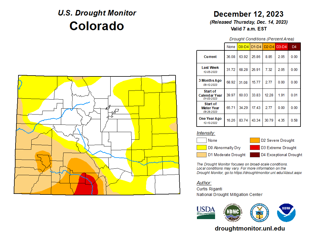
🥵 Aridification Watch 🐫

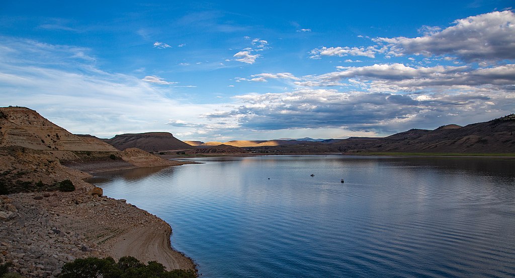
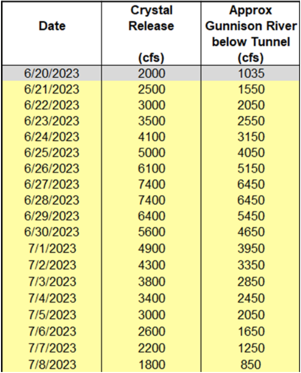
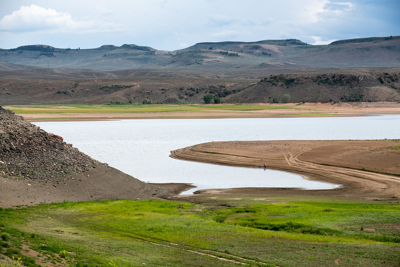
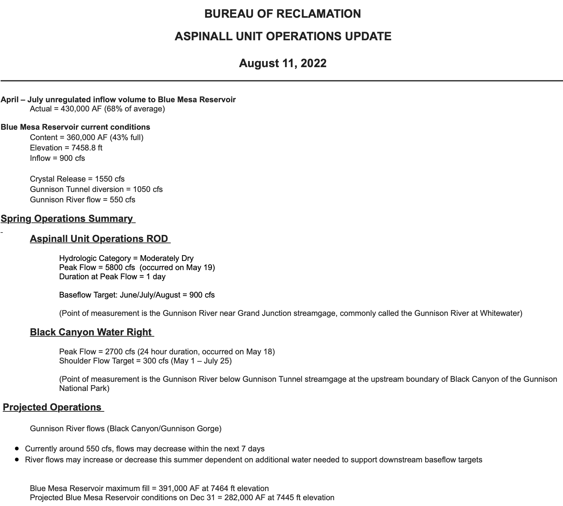
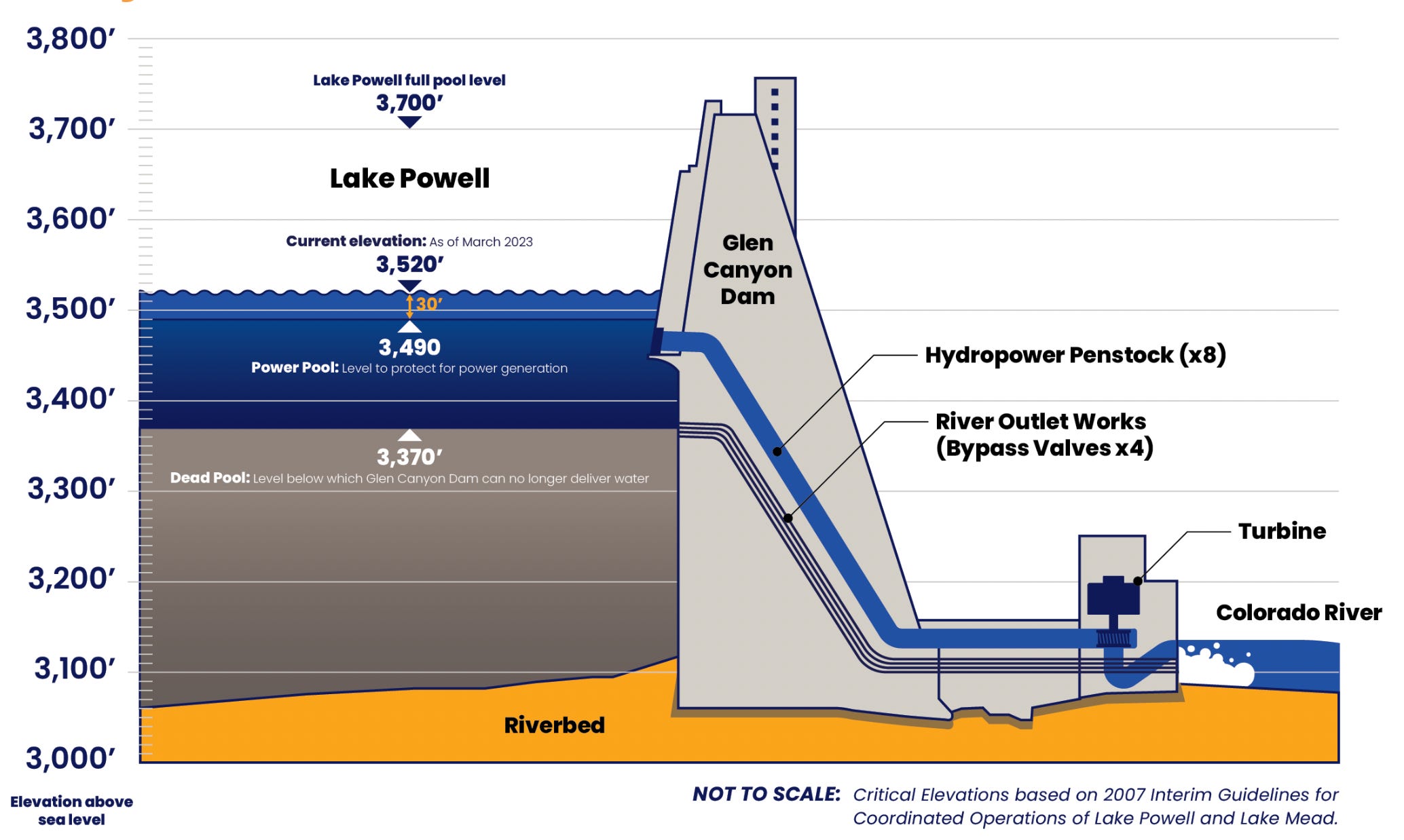
Clarification: In Tuesday’s dispatch on the Colorado River and Lake Powell, I wrote that another dry winter would put “… the elevation of Lake Powell at 3,500 feet by this time next year. And, due to the infrastructure’s limitations, Glen Canyon Dam would have to be operated as a ‘run of the river’ facility.” That probably needs a bit more explanation. 

One smart reader pointed out that even after the surface level of Lake Powell drops below minimum power pool, or 3,490 feet in elevation, the dam can still release up to 15,000 cfs from its river outlets. Technically, managers would not be forced to go to run of the river until the surface level dropped below 3,370 feet, which is known as “dead pool.”

However, the Bureau of Reclamation is very wary of relying on the river outlets, because they weren’t designed for long-term use and could fail under those circumstances. So, BoR is intent on keeping the water levels above minimum power pool so that all releases can go through the penstocks and the hydroelectric turbines. “In effect,” the authors of the paper wrote, “at least for the short term, the engineering and safety issues associated with the ability to release water through Glen Canyon Dam mean that the amount of water actually available for release from Lake Powell is only that which exists above elevation 3500 feet.”

So, as long as this is the case, the BoR will need to go to run of the river as soon as the elevation drops to 3,500 feet. I hope that helps clear things up!

🗺️ Messing with Maps 🧭

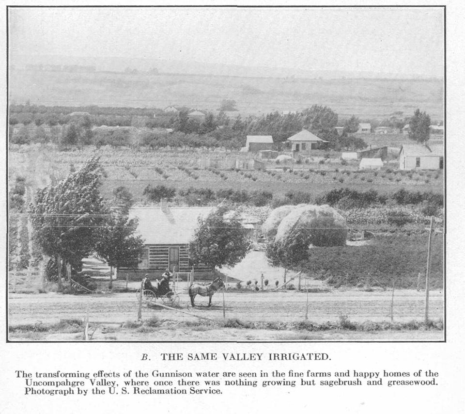
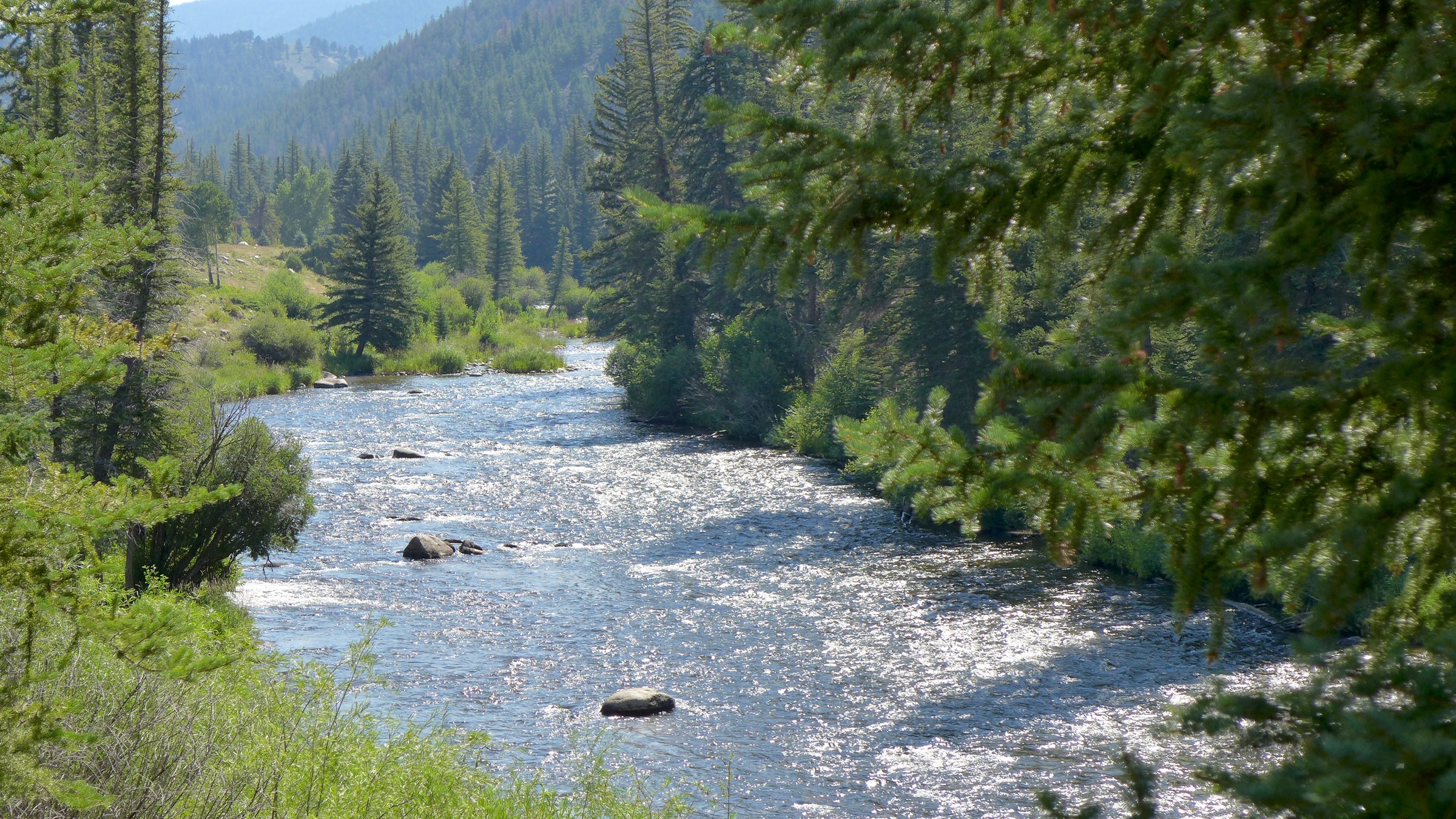
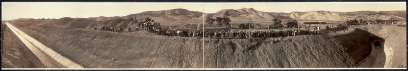
Today’s map is less about the map than it is about the publication it comes from, the USGS’s Guidebook of the Western United States Part E. the Denver & Rio Grande Western Route, published in 1922. This thing is super cool, and super detailed (it’s 384 pages long). It’s got some great photos and maps, like this one (click on the image to see it in larger size on the website).

Besides having a cool, hand drawn style, this map struck me because it was made prior to the reservoirs on the Gunnison River. And it shows how the railroad tracks used to go into the Black Canyon at Cimarron and continue along the river all the way to Gunnison (most of that section is now under water). I suppose I should have known that was where the tracks went, but it never really occurred to me before. Credit: USGS

Related to that map were these two photos illustrating the miracle of irrigation.

Map of the Gunnison River drainage basin in Colorado, USA. Made using public domain USGS data. By Shannon1 – Own work, CC BY-SA 4.0, https://commons.wikimedia.org/w/index.php?curid=69257550

#Drought puts Blue Mesa in crosshairs again — The Gunnison Country Times

Blue Mesa Reservoir. Photo credit: Curecanti National Recreation Area

Click the link to read the article on the Gunnison Country Times website (Alan Wartes). Here’s an excerpt:

August 13, 2025

After weeks of hot, dry and windy weather across western Colorado, Gunnison County Commissioners received a water-issues update on Tuesday that was filled with “sobering” news. In addition to details about Gunnison County’s worsening drought conditions, commissioners heard from representatives of the Colorado Water Conservation Board (CWCB) that the U.S. Bureau of Reclamation is once again considering emergency releases from Blue Mesa Reservoir to bolster falling water levels in Lake Powell [in 2026, h/t Sue Serling].

West Drought Monitor map August 12, 2025.

According to drought.gov, approximately 50% of Gunnison County is in “extreme” drought, compared to just 5% one month ago. Conditions in most of the remainder of the county are rated as “severe.” Precipitation for most of the county has been between 25% and 50% of normal for the past 30 days, with little immediate relief in sight.

CWCB representative Amy Ostdiek told commissioners she believes emergency releases will come from elsewhere in the Upper Basin this year, but couldn’t rule out the possibility that Blue Mesa would be included…If current conditions persist, Lake Powell is projected to fall below the critical elevation of 3,525 feet above sea level in the spring of 2026. This would be the second time that has occurred since the reservoir filled in 1980. The other time happened in 2021, precipitating emergency releases from Blue Mesa Reservoir and Flaming Gorge and Navajo reservoirs totaling 180,000 acre-feet. An acre-foot is the volume of water that would cover one acre a foot deep.

As of Aug. 10, Blue Mesa was 61% full and is projected to end the year at 51% of its storage capacity — without any additional releases. Taylor Reservoir is forecasted to be at 65% of average capacity at the end of 2025. The threshold of 3,525 feet at Lake Powell was agreed to in the Upper Basin Drought Response Operations Agreement as the trigger point for possible releases. The purpose is to prevent Lake Powell from dropping below 3,490 feet, known as “dead pool” — the point at which the Glen Canyon Dam can no longer generate electricity. Up to 5 million people across six western states depend on hydroelectric power from the dam. Emergency releases in 2021 were controversial. Critics argued that federal authorities did not properly consult with Upper Basin water users prior to the decision and failed to account for impacts to local economies and communities. Further, many objected on the grounds that water managers had no way of measuring whether the extra water in fact reached Lake Powell.

Credit: USGS and Reclamation 2023

Notice of Upper Gunnison River Water Conservancy District Board and Lake San Cristobal Water Activity Enterprise Meetings on Tuesday, May 20, 2025 in Lake City, Colorado #GunnisonRiver

Map of the Gunnison River drainage basin in Colorado, USA. Made using public domain USGS data. By Shannon1 – Own work, CC BY-SA 4.0, https://commons.wikimedia.org/w/index.php?curid=69257550

From email from the Upper Gunnison River Water Conservancy District (Sue Uerling):

Please see the attached notice for the May Upper Gunnison River Water Conservancy District and Lake San Cristobal Water Activity Enterprise Meetings in Lake City, Colorado on Tuesday, May 20th, 2025 with lunch beginning at noon.  If you would like to join the meeting via Zoom, please use the following link to pre-register for the meeting:

https://us02web.zoom.us/meeting/register/tZIpfuiprT8uHNakChm1C21AdG737XbK7MUu

Questions?  Please contact the District at (970)641-6065

Aspinall Unit operations update April 13, 2025

Aspinall Unit dams

From email from Reclamation (Erik Knight):

Releases from the Aspinall Unit will be increased from 1200 cfs to 1500 cfs Monday, April 14th.  Releases are being increased to coincide with increasing diversions at the Gunnison Tunnel.

Flows in the lower Gunnison River are currently above the baseflow target of 1050 cfs. After this release change river flows are expected to remain above the baseflow target for the foreseeable future.

Pursuant to the Aspinall Unit Operations Record of Decision (ROD), the baseflow target in the lower Gunnison River, as measured at the Whitewater gage, is 1050 cfs for April through May.

Currently, Gunnison Tunnel diversions are 620 cfs and flows in the Gunnison River through the Black Canyon are around 590 cfs. After this release change Gunnison Tunnel diversions will be around 1050 cfs and flows in the Gunnison River through the Black Canyon will be around 450 cfs. Current flow information is obtained from provisional data that may undergo revision subsequent to review.

This scheduled release change is subject to changes in river flows and weather conditions. For questions or concerns regarding these operations contact:

Erik Knight at (970) 248-0629, e-mail eknight@usbr.gov

Map of the Gunnison River drainage basin in Colorado, USA. Made using public domain USGS data. By Shannon1 – Own work, CC BY-SA 4.0, https://commons.wikimedia.org/w/index.php?curid=69257550

Romancing the River: Remembering Dick Bratton – and His Times — George Sibley (SibleysRivers.com)

Photo credit: Sibley’s Rivers

Click the link to read the article on the Sibley’s Rivers website (George Sibley):

February 17, 2025

Well, with the fate of constitution democracy in the courts where we know the mills grind slowly (as opposed to the grinders who break things quickly); and with the money frozen for farmers doing well by doing good in water conservation; and neither white smoke nor black smoke arising from the chimneys of the enclaves trying to envision the next decade or so for the Colorado River – I’ll take a break from my wonkish efforts to think outside the box, to remember a friend and mentor, and friend of the River, who thought outside the box often in the last half of the 20th century.

The cantankerous Colorado River water community recently lost a valued member, L. Richard Bratton, a water attorney in the Upper Gunnison River Basin from 1958 till his death January 28.

Dick Bratton’s scope of influence went beyond the Upper Gunnison mountain valleys, however; he was a creative thinker who never met anyone he could not talk to – or listen to, or work with. A born “connector,” he became an active player in events on the cusp of major changes in the development of water in the entire Upper Basin of the Colorado River.

Born in 1932 and raised in Salida, Dick Bratton came to Gunnison to attend Western State College, then went to the University of Colorado Law School. While at school in Gunnison, he had met Ed Dutcher, a somewhat legendary West Slope water attorney. Shortly after Bratton completed law school, Dutcher invited him to join his firm in 1958.

Aspinall Unit dams

Bratton joined Dutcher’s firm that year – and in 1959, the Colorado River Storage Project (CRSP) came to the Upper Gunnison River Valley in a big way, with Congressional approval of funding for CRSP’s Curencanti Project (Blue Mesa, Morrow Point and Crystal Dams, now renamed the Wayne Aspinall Unit), and he found himself plunged into all of the ongoing and emerging challenges faced by small communities with agrarian roots in an urbanizing and industrializing world.

The first challenge was Theodore Roosevelt’s conservation vision. The “Father of American Conservation” had a different view of conservation than most of us have today; to him and his philosopher sidekick Gifford Pinchot, conservation meant first the orderly development of resources otherwise wasted – like the Colorado River pouring itself into the sea in a two-month uncontrolled and mostly unused flood of snowmelt. And when it came to what should be developed and by and for whom, their rule was “the greatest good for the greatest number,” with “for the longest time” sometimes remembered, sometimes not.

In the Upper Gunnison, the Bureau of Reclamation had chosen the Curecanti Reservoir site not to benefit the small ranches and farms of the Upper Gunnison valleys, in accord with their original Rooseveltian mission. It was chosen because it was a great site for a major reservoir in a regional water development for four states that were paranoid over their obligation to make sure a set amount of water passed on to the three more populous states below the Colorado River canyons. The greatest good for the greatest number.

The Curecanti Reservoir as originally proposed, however, would have backed 2.5 million acre-feet (maf) of water almost up to the city limits of Gunnison, with the shallow end exposing major mudflats every summer as the reservoir was drawn down, and the prevailing westerlies would have turned Gunnison into a dust bowl. Bratton’s partner and mentor Ed Dutcher had invested much of his career into opposing this local sacrifice for the greatest good for the greatest number – not just standard NIMBYism; the community was fighting for its life, and also for the life of two small towns that would be inundated along with 30 miles of legendary fishing stream, 23 small river resorts, and 6,000 acres of ranchland.

After much noisy negotiation with the Bureau of Reclamation for Dutcher and his “Committee of 39,” the Bureau dropped the reservoir size to just under one million acre-feet, saving Gunnison from the dust inundation, but still losing the two smaller towns and their economic activities – and the great fishing.

Being sensitive to the cost the project was imposing on the ranchers and farmers that the Bureau was actually created to serve, however, an “Upper Gunnison River Project” with seveeral small reservoirs was included as a future participating project in the CRSP Act, to be paid for partially by the revenues from the hydroelectric plant on the three largest CRSP dams: Glen Canyon, Flaming Gorge and the Curecanti Unit.

So one of Bratton’s first jobs in Gunnison was helping talk the people of the valley into taxing themselves a little to create an Upper Gunnison River Water Conservancy District under state law, both to help the Bureau lobby for project funding in Washington, and to nudge and harass the Bureau into getting project planning and execution done. Creating the Conservancy was accomplished in an election in 1959, a busy year for Dutcher and Bratton.

In 1961 Dutcher was appointed to a judgeship, and Bratton took over the law firm. That same year, the Bureau opened an office in Gunnison, and began the preliminary work for the Curecanti Project – clearing the land of trees, relocating roads, and buying out all of the human occupants, an unpleasant and depressing process in the valley. The “greatest good for the greatest number” rule, applied in many areas other than conservation, has nothing in the formula for the “lesser numbers” – probably one source of our current urban-rural troubles.

As construction proceeded on the Curecanti dams, though, a “big pivot” in the way the entire nation perceived the American West was becoming unignorable. The Bureau of Reclamation had depended on the willingness of the American people to continue investing in the “reclaiming” of arid lands to create more of the iconic “family farms” and to otherwise further the development of raw resources to feed the people and industries of an increasingly urbanized and industrialized economy. But the increasingly urbanized, industrialized – and after the Second War, increasingly mobilized – American people were enjoying a rising standard of living that included more time for recreation – paid vacations! – and “their” western public lands were increasingly perceived not as a resource hinterland, but as a vacation paradise, to be kept as pure and pristine as possible with millions of people trampling through.

On Bratton’s home front, the Crested Butte Ski Resort also opened in 1961 upvalley, forcing the beginning of a transition in the Upper Gunnison’s self-perception as part of the mining, farming and ranching “working west,” as opposed to a service sector serving visitors to the great western playground. “Conservation” was swinging from the Rooseveltian orderly development of otherwise “wasted” resources toward conservation as careful guarding of the West’s resources, including preservation of its residual wild magnificence, Wallace Stegner’s “society to match its scenery.”

Bratton himself was the son of a “working west” family, with a couple generations before him in Colorado engaged in mining and mining-related economic activities. But like the political creator of the Colorado River Storage Project, West Slope Congressman Wayne Aspinall, Bratton could see where things were going, and worked to make the transition at home as non-disruptive as possible for the “Old West” yielding to the “New West.” (Aspinall’s CRSP Act included provisions for recreational facilities around the major dam sites – but also provisions for a number of “Old West” valley-scale projects that could not meet cost-benefit analyses on their own without assistance from hydropower revenues.)

The Taylor River, jewel of the Gunnison River basin. Photo: Brent Gardner-Smith/Aspen Journalism

The creative quality of Bratton’s work in that transition is probably best shown in the story of the resurrection of the Taylor River. The Taylor River collected runoff from some of the highest and snowiest peaks of the Continental Divide and came down to the Gunnison River through 25 miles of canyons – a beautiful mountain river with a reputation among “anglers” (don’t even say “bait”) as a world-class fishery, even in the early 20th century.

But in the 1930s, the Bureau put a dam at the head of the canyons to store late-season water for farmers in the Uncompaghre River valley, more than a hundred miles downriver at the receiving end of the Gunnison Tunnel, the Bureau’s first big transbasin water project. That project to make life better for distant farmers effectively killed the Taylor and its aquatic life as a river, reversing its natural wet and dry cycles and turning it into an irrigation canal that ran at the will of the Bureau. This was a great loss to the people of the Upper Gunnison, who knew that the best time for fishing was after work anyway. The loss of the Taylor was their first lesson in what the greater good for a greater number meant for the lesser number.

And the Curecanti Project was their second lesson, inundating another twenty-some miles of world-class fishery, along with two small towns and a fishing-resort community that made decent livings from the river. But the Upper Gunnison farmers and ranchers held out hope that, once the Curecanti Unit was in place to play its role in the larger world of Colorado River Basin policy and politics, the Bureau would at least fulfill its promise and begin work on the Upper Gunnison River Project to give them a little help with late-season water.

But just in the decade-and-a-half from the difficult passage of the CRSP Act in 1956 to the completion of the Curecanti Project, public support for expensive irrigation projects to develop western lands basically dried up, replaced by active opposition to anything disturbing the natural beauty and magnificence of The West. It became obvious to the Upper Gunnison Conservancy board and Bratton – attorney on retainer to the board for its first 40 years – that there would be no federal funds for an Upper Gunnison River Project.

But Bratton – a convener and collaborator who managed to maintain good working relationships even with opponents – started to play on the Bureau’s guilt at not being able to fulfill their promise to the people of the Upper Gunnison. He found a willing collaborator in Bob Jennings, a Bureau manager in the West Slope office. Together, they devised a plan whereby the Bureau would let the Uncompaghre Valley Water Users Association store their Taylor Reservoir water in the Blue Mesa Reservoir – at least a day closer to where the water would be used. Then the water could be moved from the Taylor Reservoir down to Blue Mesa from in a schedule more in tune with the natural flow of a river. Maybe the Bureau could not create small upstream reservoirs for the “Old West” agrarian economy, but it could facilitate the resurrection of a beautiful river for the “New West” economy taking shape (and Old West workers who liked to fish).

Taylor Dam. By WaterArchives.org – CO-A-0034, WaterArchives.org, CC BY-SA 4.0, https://commons.wikimedia.org/w/index.php?curid=36300145

This was accomplished with a 1975 agreement among the Uncompahgre Valley farmers, the Colorado River Water Conservation District, the Upper Gunnison River Water Conservancy, and the Bureau. The Bureau would manage the “new” river, but with input from the other three parties – input that begins each spring with a meeting of an Upper Gunnison River “Local Users Group”: representatives from Taylor River irrigators, whitewater recreation businesses, Taylor Reservoir flatwater businesses, anglers, and riparian residents. This group sits down with projections for the summer runoff, and compile suggestions for the Bureau on the operation of the Taylor River that will meet all their needs more or less (and being sure to get the Uncompahgre farmers’ water down to Blue Mesa storage in a timely way). The Bureau and other parties can override their recommendations, but seldom need to. And the Taylor is a beautiful mountain river again – “unnatural” only in being democratically operated by all of its Old West and New West users.

Bratton did not stop there. He led the Upper Gunnison River Water Conservancy District through the process of filing for rights on a secondfill of the Taylor Reservoir. Taylor Park above the reservoir gathers on average half again the 110,000 af needed for the Uncompahgre users first fill. Any water collected in a second fill would be left in the river, for wildlife and other environmental benefits downriver – a right consistent with Colorado’s 1973 instream flow law, to sustain the aquatic and riparian environment “to a reasonable degree.” This water right, inconceivable before the 1970s and NEPA awarenesss, was granted in 1990 – just in time to help thwart a proposal for a transmountain diversion to the Front Range from the adjacent Union Park.

Even then, Bratton was not yet done playing on Bureau guilt for imposing the Curecanti Unit on the Upper Gunnison with no compensatory project for the local water users – even though the Upper Gunnison community generates a lot of economic activity from the Curecanti National Recreation Area around Blue Mesa Reservoir. Early in the 21st century, Bratton wanted to develop some ranchland he owned adjacent to the City of Gunnison, with a tributary of the Gunnison River running through it. This development was not received by local residents with any great enthusiasm.

But Bratton remembered a ‘handshake agreement’ with the Bureau from the Curecanti construction era, that the Bureau would replace the great sport fishery the reservoir would inundate with some good public access fishing streams elsewhere in the basin. So rather than developing a standard golf-course-rimmed-with-expensive-homes development, Bratton reminded the Bureau of its promise, and sold it the stream corridor through his land for public access, to be managed by Colorado Parks and Wildlife.

Bratton was also deeply committed to his alma mater, Western State College (now Western Colorado University). In 1975 – obviously a busy year in his life – he orchestrated the creation of the Western State College Foundation, with bequests from former Colorado Governor Dan Thornton and his wife Jessie, valley ranchers; the Foundation continues as an important support for program development at the University.

The following year, 1976, he collaborated with Western history professor Duane Vandenbusche on a water education course. The next year, 1977, that evolved into the “Western Water Workshop,” to which Bratton invited an incredible lineup of speakers, including – in the same room – longtime West Slope Congressman Wayne Aspinall, Denver Water’s longtime chief counsel and bitter West Slope adversary Glenn Saunders, Assistant Bureau of Reclamation Director Cliff Barrett, former Governor John Vanderhoof, and a number of other luminaries of the “water buffalo era.” Your author was privileged to sneak into those summer sessions – one of the most memorable of which was Bureau man Cliff Barrett trying to suss out the implications of President Carter’s recently released “hit list,” a list of water projects, including a number of CRSP projects, that did not meet a new cost-benefit analysis – essentially the official end of the era of federally-funded western water development.

The Western Water Workshop continued for forty years; a place where East Slope and West Slope, Old West and New West participants could gather for a couple days of off-the-record escape from the physical and cultural heat of the cities in the summer. I sserved as director of the Workshop for six year after the turn of the century until I retired from Western, and I found Dick Bratton to still be a great resource and idea person. At that time he had been appointed by President G. W. Bush to be the federal representative on the Upper Colorado River Commission. He once took pains to save my Water Workshop job when I had inadvertently offended one of the old “water buffalo” with a couple invitees to a session; Bratton reminded his old friend that the Workshop promised “the presentation of all reasonable points of view.”

The reader may feel this article is more a history lesson than the remembrance of a man. (A full obituary can be found in the Feburary 6 Gunnison Country Times – www.gunnisontimes.com) But it is my feeling that some people cannot be understood outside of the history they are part of, and Dick Bratton was such a person. Like his friend Wayne Aspinall, he tried to help Colorado’s West Slope (and the larger intermountain West) negotiate the difficult, inevitable, and ongoing transition from the “Old West working economy” to the “New West amenity economy.” His heart may have been more with the former, but he became at home with the latter because, basically, he was at home in the world, whatever it was, and enjoying working with whomever he encountered there. And he was a fisherman as well as the son of a miner.

Greg Hobbs, Dick Bratton, Jim Pokrandt

The next coordination meeting for the operation of the Aspinall Unit is scheduled for Thursday, January 23rd 2025, at 1:00 pm #GunnisonRiver

Crystal Dam, part of the Colorado River Storage Project, Aspinall Unit. Credit Reclamation.

From email from Reclamtion (Erik Knight):

This meeting will be held at the Western Colorado Area Office in Grand Junction, CO. There will also be an option for virtual attendance via Microsoft Teams. A link to the Teams meeting is below. 

The meeting agenda will include updates on current snowpack, forecasts for spring runoff conditions and spring peak operations, the weather outlook, and planned operations for the remainder of the year. 

Handouts of the presentations will be emailed prior to the meeting.

Microsoft Teams Need help?

Join the meeting now

Meeting ID: 277 950 010 81

Passcode: nY7qX7sr

Aspinall Unit operations update October 30, 2024: Ramping down Gunnison Tunnel diversions for the season #GunnisonRiver

Gunnison Tunnel via the National Park Service

From email from Reclamation (Erik Knight):

On Wednesday and Thursday, October 30 and 31, diversions to the Gunnison Tunnel will be ramped down for the season. Releases from the Aspinall Unit will be adjusted in coordination with the ramp down schedule for Gunnison Tunnel diversions in order to keep Gunnison River flows near the current level of 370 cfs. There could be fluctuations in the river throughout these days until the Gunnison Tunnel is completely shut down.

On Wednesday, October 30, releases from the Aspinall Unit and Gunnison Tunnel diversions will be reduced by 300 cfs. On Thursday, October 31, releases from the Aspinall Unit and Gunnison Tunnel diversions will be reduced by 650 cfs and Tunnel diversions will be ended until next year.

Flows in the lower Gunnison River are currently above the baseflow target of 1050 cfs. River flows are expected to stay above the baseflow target for the foreseeable future. 

Pursuant to the Aspinall Unit Operations Record of Decision (ROD), the baseflow target in the lower Gunnison River, as measured at the Whitewater gage, is 1050 cfs for October through December.

Currently, diversions into the Gunnison Tunnel are around 980 cfs and flows in the Gunnison River through the Black Canyon are around 370 cfs. After the shutdown of the Gunnison Tunnel, flows in the Gunnison River through the Black Canyon will still be near 370 cfs. Current flow information is obtained from provisional data that may undergo revision subsequent to review.

This scheduled release change is subject to changes in river flows and weather conditions. For questions or concerns regarding these operations contact Erik Knight at (970) 248-0629 or e-mail at eknight@usbr.gov

Aspinall Unit operations update August 26, 2024: Bumping down to 400 cfs in Black Canyon

A double rainbow arches over the Painted Wall in Black Canyon at Gunnison National Park. Photo Credit: Dave Showalter

From email from Reclamation (Erik Knight):

Releases from the Aspinall Unit will be decreased from 1500 cfs to 1450 cfs in the afternoon of Monday, August 26th.  Releases are being decreased as flows on the lower Gunnison River are well above the baseflow target of 1050 cfs.

Flows in the lower Gunnison River are currently above the baseflow target of 1050 cfs. River flows are expected to remain above the baseflow target for the foreseeable future.

Pursuant to the Aspinall Unit Operations Record of Decision (ROD), the baseflow target in the lower Gunnison River, as measured at the Whitewater gage, is 1050 cfs for August through December.

Currently, Gunnison Tunnel diversions are 1050 cfs and flows in the Gunnison River through the Black Canyon are around 450 cfs. After this release change Gunnison Tunnel diversions will still be 1050 cfs and flows in the Gunnison River through the Black Canyon will be around 400 cfs. Current flow information is obtained from provisional data that may undergo revision subsequent to review.

Aspinall Unit operations update August 21, 2024: Bumping down to 450 cfs through Black Canyon #GunnisonRiver

Gunnison River Basin. By Shannon1 – Own work, CC BY-SA 4.0, https://commons.wikimedia.org/w/index.php?curid=69257550

From email from Reclamation (Erik Knight):

Releases from the Aspinall Unit will be decreased from 1550 cfs to 1500 cfs on Wednesday, August 21st.  Releases are being decreased as flows on the lower Gunnison River are well above the baseflow target of 1050 cfs. Another reduction in the release at Crystal is expected to occur next week if river levels remain above the target.

Flows in the lower Gunnison River are currently above the baseflow target of 1050 cfs. River flows are expected to remain above the baseflow target for the foreseeable future.

Pursuant to the Aspinall Unit Operations Record of Decision (ROD), the baseflow target in the lower Gunnison River, as measured at the Whitewater gage, is 1050 cfs for August through December.

Currently, Gunnison Tunnel diversions are 1050 cfs and flows in the Gunnison River through the Black Canyon are around 500 cfs. After this release change Gunnison Tunnel diversions will still be 1050 cfs and flows in the Gunnison River through the Black Canyon will be around 450 cfs. Current flow information is obtained from provisional data that may undergo revision subsequent to review.

This scheduled release change is subject to changes in river flows and weather conditions. For questions or concerns regarding these operations contact:

Erik Knight at (970) 248-0629, e-mail eknight@usbr.gov

Aspinall Unit Operations update August 20, 2024: 500 cfs through Black Canyon #GunnisonRiver

Black Canyon July 2020. Photo credit: Cari Bischoff

From email from Reclamation (Erik Knight):

Releases from the Aspinall Unit will be decreased from 1650 cfs to 1550 cfs on Tuesday, August 20th.  Releases are being decreased as flows on the lower Gunnison River are well above the baseflow target of 1050 cfs. Further reductions in the release at Crystal may occur soon if river levels remain well above the target.

Flows in the lower Gunnison River are currently above the baseflow target of 1050 cfs. River flows are expected to remain above the baseflow target for the foreseeable future.

Pursuant to the Aspinall Unit Operations Record of Decision (ROD), the baseflow target in the lower Gunnison River, as measured at the Whitewater gage, is 1050 cfs for August through December.

Currently, Gunnison Tunnel diversions are 1050 cfs and flows in the Gunnison River through the Black Canyon are around 600 cfs. After this release change Gunnison Tunnel diversions will still be 1050 cfs and flows in the Gunnison River through the Black Canyon will be around 500 cfs. Current flow information is obtained from provisional data that may undergo revision subsequent to review.

This scheduled release change is subject to changes in river flows and weather conditions. For questions or concerns regarding these operations contact:

Erik Knight at (970) 248-0629, e-mail eknight@usbr.gov

Aspinall Unit Coordination Meeting August 15, 2024

Colorado River in Grand Junction. Photo credit: Allen Best

From email from Reclamation (Erik Knight):

The next coordination meeting for the operation of the Aspinall Unit is scheduled for Thursday, August 15th 2024, at 1:00 pm. 

This meeting will be held at the Western Colorado Area Office in Grand Junction, CO. There will also be an option for virtual attendance via Microsoft Teams. A link to the Teams meeting is below. 

The meeting agenda will include a review of the spring runoff conditions and the forecasting , a summary of reservoir conditions and river flows since April including the spring peak operation, the weather outlook, and planned operations for the remainder of the year. 

Handouts of the presentations will be emailed prior to the meeting.

Aspinall Unit operations update: Streamflow in Black Canyon will be around 600 cfs, August 31, 2024 #GunnisonRiver #ColoradoRiver #COriver #aridification

Sunrise Black Canyon via Bob Berwyn

From email from Reclamation (Erik Knight):

Releases from the Aspinall Unit will be decreased from 2100 cfs to 1650 cfs by Thursday, August 1st. Releases are being decreased as the baseflow target for the lower Gunnison River will change to 1050 cfs on August 1st.

Flows in the lower Gunnison River are currently above the baseflow target of 1500 cfs. River flows are expected to remain above the new baseflow target with this release reduction.

Pursuant to the Aspinall Unit Operations Record of Decision (ROD), the baseflow target in the lower Gunnison River, as measured at the Whitewater gage, is 1050 cfs for August through December.

Currently, Gunnison Tunnel diversions are 1050 cfs and flows in the Gunnison River through the Black Canyon are around 1050 cfs. After this release change Gunnison Tunnel diversions will still be 1050 cfs and flows in the Gunnison River through the Black Canyon will be around 600 cfs. Current flow information is obtained from provisional data that may undergo revision subsequent to review.

The #ColoradoRiver: Strategies from lower and upper basin states to reduce water consumption — The Deseret News #COriver #aridification

“New plot using the nClimGrid data, which is a better source than PRISM for long-term trends. Of course, the combined reservoir contents increase from last year, but the increase is less than 2011 and looks puny compared to the ‘hole’ in the reservoirs. The blue Loess lines subtly change. Last year those lines ended pointing downwards. This year they end flat-ish. 2023 temps were still above the 20th century average, although close. Another interesting aspect is that the 20C Mean and 21C Mean lines on the individual plots really don’t change much. Finally, the 2023 Natural Flows are almost exactly equal to 2019. (17.678 maf vs 17.672 maf). For all the hoopla about how this was record-setting year, the fact is that this year was significantly less than 2011 (20.159 maf) and no different than 2019” — Brad Udall

Click the link to read the article on The Deseret News website (Emma Pitts). Here’s an excerpt:

July 9, 2024

In 2022, Lake Powell was at its lowest since it was originally filled in the 1960s. [Amy] Haas noted an ongoing concern that there is currently no mechanism to ensure the conserved water from the upper basin states is flowing down to Lake Powell and staying there.

The relationship between the upper and lower basin states is not always pleasant, but [Gene] Shawcroft noted that recently, agreements and understandings have been made between the entities…In their post-2026 operations proposal, the lower basin states said they would cut water use by 1.5 million acre-feet per year as long as Lake Powell and Lake Mead’s combined storage remains at a certain level. Shawcroft added that the question now is, at what point, do these cuts in water use begin?

“The upper division states feel very strongly that we need to improve our storage (and) that we need additional storage. And so our concept would be that we would have that one-and-a-half reduction occur at an elevation that was higher than what they would propose. Their position, or their thought process is, if there’s water in the system, we ought to put it to use,” he said.

Haas added, “The lower basin is proposing actions based on total system contents as they define it, which includes not only Lake Powell and Lake Mead but also the upstream initial units, right? So this would be Flaming Gorge, the Aspinall unit in Colorado and Navajo.”

Map credit: AGU

Aspinall Unit operations update July 10, 2024

Morrow Point Dam, on the Gunnison River, Aspinall Unit. Photo: Brent Gardner-Smith/Aspen Journalism

From email from Reclamation (Erik Knight):

Releases from the Aspinall Unit will be increased from 1600 cfs to 1900 cfs between Wednesday, July 10th and Thursday, July 11th.  Releases are being increased in response to declining river flows on the lower Gunnison River.

Flows in the lower Gunnison River have been dropping quickly towards the baseflow target of 1500 cfs. River flows are expected to continue to decline over the next couple weeks.

Pursuant to the Aspinall Unit Operations Record of Decision (ROD), the baseflow target in the lower Gunnison River, as measured at the Whitewater gage, is 1500 cfs for July and then drops to 1050 cfs in August.

Currently, Gunnison Tunnel diversions are 1050 cfs and flows in the Gunnison River through the Black Canyon are around 600 cfs. After this release change Gunnison Tunnel diversions will still be 1050 cfs and flows in the Gunnison River through the Black Canyon will be near 900 cfs. Current flow information is obtained from provisional data that may undergo revision subsequent to review.

The next Aspinall Unit Operations meeting is August 15, 2024

Blue Mesa Reservoir. MichaelKirsh / CC BY-SA (https://creativecommons.org/licenses/by-sa/4.0)

From email from Reclamation (Erik Knight):

July 8, 2024

The next Aspinall Operations meeting is officially scheduled for Thursday, August 15th. We have moved from the August 22nd date due to the conflict with Water Congress. Start time will be the usual 1:00pm

The meeting will be held at the Western Colorado Area Office in Grand Junction. Due to the ongoing repairs of the US50 bridge over Blue Mesa Reservoir we have decided not to hold the meeting at the desired location of the Elk Creek Visitor Center at Blue Mesa Reservoir.

Aspinall Unit Operations update June 11, 2024 #GunnisonRiver #ColoradoRiver #COriver #aridification

Aspinall Unit dams

From email from Reclamation (Erik Knight):

Aspinall Unit operations forecast May 17, 2024 — Reclamation #GunnisonRiver #ColoradoRiver #COriver #aridification

Aspinall Unit spring operations update

Aspinall Unit dams

From email from Reclamation (Erik Knight):

The next coordination meeting for the operation of the Aspinall Unit is scheduled for Thursday, January 18th 2024, at 1:00 pm — Reclamation #GunnisonRiver #ColoradoRiver #COriver #aridification

Black Canyon July 2020. Photo credit: Cari Bischoff

From email from Reclamation (Erik Knight):

The next coordination meeting for the operation of the Aspinall Unit is scheduled for Thursday, January 18th 2024, at 1:00 pm.

This meeting will be held at the Holiday Inn Express in Montrose, CO. There will also be an option for virtual attendance via Microsoft Teams. A link to the Teams meeting will be emailed next week along with the meeting handouts.

The meeting agenda will include a review of operations and hydrology since August, current soil and snowpack conditions, a discussion of hydrologic forecasts, the weather outlook, and planned operations for this water year. There will also be a presentation by American Whitewater on the development of the Environmental & Recreational Flow Tool.

Aspinall Unit dams

Aspinall Unit operations update December 20, 2023 #GunnisonRiver #ColoradoRiver #COriver #aridification

Colorado Drought Monitor map December 12, 2023.

From email from Reclamation (Erik Knight):

Releases from the Aspinall Unit will be decreased from 650 cfs to 575 cfs on Wednesday, December 20th.  Releases are being decreased in response to drier than average conditions in the Gunnison Basin. 

Flows in the lower Gunnison River are currently above the baseflow target of 1050 cfs. River flows are expected to remain above the baseflow target for the foreseeable future. 

Pursuant to the Aspinall Unit Operations Record of Decision (ROD), the baseflow target in the lower Gunnison River, as measured at the Whitewater gage, will be 1050 cfs for December. 

Currently, Gunnison Tunnel diversions are 0 cfs and flows in the Gunnison River through the Black Canyon are around 620 cfs. After this release change Gunnison Tunnel diversions will still be 0 cfs and flows in the Gunnison River through the Black Canyon will be near 550 cfs. Current flow information is obtained from provisional data that may undergo revision subsequent to review.

Aspinall Unit operations update: Gunnison Tunnel diversions end for this season #GunnisonRiver #ColoradoRiver #COriver #aridification

Official opening of the Gunnison Tunnel by President Taft at the west portal

From email from Reclamation (Erik Knight):

Releases from the Aspinall Unit will be decreased from 850 cfs to 350 cfs on Tuesday, November 14th.  Releases are being decreased in response to the end of irrigation diversions to the Gunnison Tunnel.  The Gunnison Tunnel will be shut down on November 14th. 

Flows in the lower Gunnison River are currently above the baseflow target of 1050 cfs. River flows are expected to remain above the baseflow target for the foreseeable future. 

Pursuant to the Aspinall Unit Operations Record of Decision (ROD), the baseflow target in the lower Gunnison River, as measured at the Whitewater gage, will be 1050 cfs for November and December. 

Currently, Gunnison Tunnel diversions are 500 cfs and flows in the Gunnison River through the Black Canyon are around 320 cfs. After this release change Gunnison Tunnel diversions will be 0 cfs and flows in the Gunnison River through the Black Canyon will still be near 320 cfs. Current flow information is obtained from provisional data that may undergo revision subsequent to review. 

Aspinall Unit operations update: Bumping releases down to 800 cfs November 2, 2023 #GunnisonRiver #ColoradoRiver #COriver #aridification

Grand opening of the Gunnison Tunnel in Colorado 1909. Photo credit USBR.

From email from Reclamation (Erik Knight):

Releases from the Aspinall Unit will be decreased from 1100 cfs to 800 cfs on Thursday, November 2nd.  Releases are being decreased in response to a decrease in diversions at the Gunnison Tunnel.  Tunnel diversions will be reduced by 300 cfs on November 1st, so there will be a short period of higher flow in the Gunnison River through the Black Canyon before the release change at Crystal Dam. 

Flows in the lower Gunnison River are currently above the baseflow target of 1050 cfs. River flows are expected to remain above the baseflow target for the foreseeable future. 

Pursuant to the Aspinall Unit Operations Record of Decision (ROD), the baseflow target in the lower Gunnison River, as measured at the Whitewater gage, will be 1050 cfs for November through December. 

Currently, Gunnison Tunnel diversions are 800 cfs and flows in the Gunnison River through the Black Canyon are around 320 cfs. After this release change Gunnison Tunnel diversions will be 500 cfs and flows in the Gunnison River through the Black Canyon will still be near 320 cfs.  Gunnison Tunnel diversions are expected to stay near 500 cfs for the first 2 weeks of November for late season irrigation of the winter wheat crop. Current flow information is obtained from provisional data that may undergo revision subsequent to review. 

Aspinall Unit operations update: Bumping down to 1100 cfs #GunnisonRiver #ColoradoRiver #COriver #aridification

Sunrise Black Canyon via Bob Berwyn

From email from Reclamation (Erik Knight):

Releases from the Aspinall Unit will be decreased from 1150 cfs to 1100 cfs on Wednesday, October 18th.  Releases are being decreased in response to declining inflow forecasts for the Aspinall Unit.   

Flows in the lower Gunnison River are currently above the baseflow target of 1050 cfs. River flows are expected to remain above the baseflow target for the foreseeable future. 

Pursuant to the Aspinall Unit Operations Record of Decision (ROD), the baseflow target in the lower Gunnison River, as measured at the Whitewater gage, will be 1050 cfs for October through December. 

Currently, Gunnison Tunnel diversions are 825 cfs and flows in the Gunnison River through the Black Canyon are around 400 cfs. After this release change Gunnison Tunnel diversions will still be 825 cfs and flows in the Gunnison River through the Black Canyon will be near 350 cfs. Current flow information is obtained from provisional data that may undergo revision subsequent to review.

Aspinall Unit operations update June 7, 2023 #GunnisonRiver #COriver #aridification

Aspinall Unit dams

From email from Reclamation (Erik Knight):

The June 1st forecast for the April – July unregulated inflow volume to Blue Mesa Reservoir is 845,000 acre-feet. This is 133% of the 30 year average. Snowpack in the Upper Gunnison Basin peaked at 138% of average. Blue Mesa Reservoir current content is 625,000 acre-feet which is 75% of full. Current elevation is 7496 ft. Maximum content at Blue Mesa Reservoir is 828,00 acre-feet at an elevation of 7519.4 ft. 

High flows along tributaries downstream of the Aspinall Unit helped with meeting the Aspinall Unit ROD targets on the lower Gunnison River as measured at the Whitewater gage. Releases to meet ROD targets were lower than expected and with the increase in the runoff forecast there is now a need to increase releases from the Aspinall Unit.  

Therefore ramp up of releases from the Aspinall Unit will begin on Wednesday, June 21st, with the peak release being achieved by Tuesday, June 27th. The timing of the peak release will be coordinated with required spillway gate inspections at Morrow Point Dam. The full schedule of releases from Crystal Dam with estimated Gunnison River flows is shown in the table below. 

Aspinall Unit forecast for operations May 25, 2023 #GunnisonRiver #ColoradoRiver #COriver #aridification #runoff

From email from Reclamation (Erik Knight):

Aspinall Unit operations update May 18, 2023: Black Canyon peak flow target is equal to 6,400 cfs for a duration of 24 hours #GunnisonRiver #ColoradoRiver #COriver #aridification

Black Canyon July 2020. Photo credit: Cari Bischoff

From email from Reclamation (Erik Knight):

The May 15th forecast for the April – July unregulated inflow volume to Blue Mesa Reservoir is 830,000 acre-feet. This is 131% of the 30 year average. Blue Mesa Reservoir current content is 468,000 acre-feet which is 57% of full. Current elevation is 7475.3 ft. Maximum content at Blue Mesa Reservoir is 828,000 acre-feet at an elevation of 7519.4 ft. 

Based on the May forecasts, the Black Canyon Water Right and Aspinall Unit ROD peak flow targets are listed below: 

Black Canyon Water Right 

The peak flow target is equal to 6,400 cfs for a duration of 24 hours.  

The shoulder flow target is 810 cfs, for the period between May 1 and July 25.  

Aspinall Unit Operations ROD 

The year type is currently classified as Average Wet. 

The peak flow target will be 14,300 cfs and the duration target at this flow will be 2 days. 

The half bankfull target will be 8,070 cfs and the duration target at this flow will be 20 days. 

The ramp up for the spring peak operation has been paused as flows on the Gunnison River at Whitewater are already above the spring peak target flow. Flows on the Gunnison River at Delta are close to the flow level that could impact the Delta Wastewater Treatment Plant. Currently Crystal Reservoir is spilling with a total release of 5,300 cfs. Flows in the Gunnison River through the Black Canyon are 4,600 cfs.  

With the projected increase in flows on the North Fork of the Gunnison River, releases at Morrow Pt Dam (which is now controlling the spill at Crystal Dam), will be reduced by a total of 1,400 cfs by tomorrow, May 19th. This should bring flows in the Gunnison River through the Black Canyon down to around 3,200 cfs. This release rate will be maintained through the weekend and may possibly continue well into next week.  

This adjustment to the release plan is based on the latest forecast for river flows in the Gunnison Basin. Adjustments in Aspinall Unit release rates may be made in either direction to achieve downstream target flows or if water gets too high at points along the Gunnison River through Delta.

Aspinall Unit operations update May 11, 2023: May 1st forecast for the April – July unregulated inflow volume to Blue Mesa Reservoir is 830,000 acre-feet. This is 131%of the 30-year average — Reclamation

From email from Reclamation (Erik Knight):

The May 1st forecast for the April – July unregulated inflow volume to Blue Mesa Reservoir is 830,000 acre-feet. This is 131% of the 30 year average. Snowpack in the Upper Gunnison Basin peaked at 138% of average. Blue Mesa Reservoir current content is 434,000 acre-feet which is 52% of full. Current elevation is 7470.4 ft. Maximum content at Blue Mesa Reservoir is 828,00 acre-feet at an elevation of 7519.4 ft.

Based on the May forecasts, the Black Canyon Water Right and Aspinall Unit ROD peak flow targets are listed below:

Black Canyon Water Right

The peak flow target is equal to 6,400 cfs for a duration of 24 hours.

The shoulder flow target is 810 cfs, for the period between May 1 and July 25.

Aspinall Unit Operations ROD

The year type is currently classified as Average Wet.

The peak flow target is currently 14,300 cfs and the duration target at this flow is currently 2 days.

The half bankfull target is currently 8,070 cfs and the duration target at this flow is currently 20 days.

Pursuant to the Aspinall Unit Operations ROD, releases from the Aspinall Unit will be made in an attempt to match the peak flow of the North Fork of the Gunnison River to maximize the potential of meeting the desired peak at the Whitewater gage, while simultaneously meeting the Black Canyon Water Right peak flow amount. The latest forecast for flows on the North Fork of the Gunnison River shows a high peak flow occurring near the middle of next week. Flows in the tributaries downstream of the North Fork confluence are also very high, which will help with meeting the flow targets on the lower Gunnison River at the Whitewater gage.

Therefore ramp up for the spring peak operation will begin on Friday, May 12th, with the intent of timing releases with this potential higher flow period on the North Fork of the Gunnison River. Releases from Crystal Dam will be ramped up according to the guidelines specified in the EIS, with 2 release changes per day, until Crystal begins to spill. The release schedule for Crystal Dam is: 

Crystal Dam will be at full powerplant and bypass release on May 15th. Crystal Reservoir will begin spilling by May 16th and the peak release from Crystal Dam should be reached on May 18th. The flows in the Gunnison River after that date will be dependent on the timing of the spill and the level of tributary flow contribution. Estimates of those numbers will be determined in the upcoming days.

The current projection for spring peak operations shows flows in the Gunnison River through the Black Canyon peaking at 6400 cfs in order to achieve the desired peak flow and duration at Whitewater. Actual flows will be dependent on the downstream contribution of the North Fork of the Gunnison River and other tributaries. Higher tributary flows will lead to lower releases from the Aspinall Unit and vice versa.

Photo credit: Colorado Parks & Wildlife

Aspinall unit operations update April 7, 2023 #GunnisonRiver #ColoradoRiver #COriver #aridification

Aspinall Unit operations update February 5, 2023 #GunnisonRiver #ColoradoRiver #COriver #aridification

 Aspinall Unit operations update: Coordination meeting January 19, 2023

Part of the memorial to Wayne Aspinall in Palisade. Aspinall, a Democrat, is a legend in the water sector, and is the namesake of the annual award given by the Colorado Water Congress. Photo: Brent Gardner-Smith/Aspen Journalism

From email from Reclamation (Erik Knight):

The next coordination meeting for the operation of the Aspinall Unit is scheduled for Thursday, January 19th, 2023 at 1:00 pm

As of now, the meeting is planned to be held in person as well as virtually. 

The meeting is planned to be held at the Western Colorado Area Office in Grand Junction, CO. Even if the in-person meeting needs to be cancelled, the meeting will still be held via webinar.

Information for connecting to the meeting virtually will be emailed out prior to the meeting, along with the agenda and handouts.

Aspinall Unit operations update (October 31, 2022): The #Gunnison Tunnel is turning off

Official opening of the Gunnison Tunnel by President Taft at the west portal

From email from Reclamation (Erik Knight):

Releases from the Aspinall Unit will be decreased from 950 cfs to 370 cfs on Monday, October 31st. Releases are being decreased in coordination with the shutdown of the Gunnison Tunnel on Monday, October 31st.   

Flows in the lower Gunnison River are currently above the baseflow target of 790 cfs. River flows are expected to remain above the baseflow target for the foreseeable future. 

Pursuant to the Aspinall Unit Operations Record of Decision (ROD), the baseflow target in the lower Gunnison River, as measured at the Whitewater gage, is 790 cfs for October and November. 

Currently, Gunnison Tunnel diversions are 570 cfs and flows in the Gunnison River through the Black Canyon are around 340 cfs. After this release change Gunnison Tunnel diversions will be zero and flows in the Gunnison River through the Black Canyon will still be near 340 cfs.  Current flow information is obtained from provisional data that may undergo revision subsequent to review. 

Aspinall Unit operations update (October 20, 2022): Bumping down releases to 950 cfs #GunnisonRiver #ColoradoRiver #COriver #aridification

Part of the memorial to Wayne Aspinall in Palisade. Aspinall, a Democrat, is a legend in the water sector, and is the namesake of the annual award given by the Colorado Water Congress. Photo: Brent Gardner-Smith/Aspen Journalism

From email from Reclamation (Erik Knight):

Releases from the Aspinall Unit will be decreased from 1050 cfs to 950 cfs on Thursday, October 20th. Releases are being decreased due to reduced demand at the Gunnison Tunnel.  

Flows in the lower Gunnison River are currently above the baseflow target of 790 cfs. River flows are expected to remain above the baseflow target for the foreseeable future. 

Pursuant to the Aspinall Unit Operations Record of Decision (ROD), the baseflow target in the lower Gunnison River, as measured at the Whitewater gage, is 790 cfs for October and November. 

Currently, Gunnison Tunnel diversions are 700 cfs and flows in the Gunnison River through the Black Canyon are around 340 cfs. After this release change Gunnison Tunnel diversions will be around 600 cfs and flows in the Gunnison River through the Black Canyon will still be near 340 cfs.  Current flow information is obtained from provisional data that may undergo revision subsequent to review. 

Aspinall unit operations update: Bumping releases down to 1050 cfs October 3, 2022

East Portal Gunnison Tunnel gate and equipment houses provide for the workings of the tunnel. Lisa Lynch/NPS

From email from Reclamation (Erik Knight):

Releases from the Aspinall Unit will be decreased from 1250 cfs to 1050 cfs on Monday, October 3rd. Releases are being decreased due to the heavy rainfall that occurred over the weekend which has reduced demand at the Gunnison Tunnel.  

Flows in the lower Gunnison River are currently above the baseflow target of 790 cfs. River flows are expected to remain above the baseflow target for the foreseeable future. 

Pursuant to the Aspinall Unit Operations Record of Decision (ROD), the baseflow target in the lower Gunnison River, as measured at the Whitewater gage, is 790 cfs for October. 

Currently, Gunnison Tunnel diversions are 950 cfs and flows in the Gunnison River through the Black Canyon are around 350 cfs. After this release change Gunnison Tunnel diversions will be around 750 cfs and flows in the Gunnison River through the Black Canyon will still be near 350 cfs.  Current flow information is obtained from provisional data that may undergo revision subsequent to review. 

Aspinall Unit operations update (September 24, 2022): 340 cfs in Black Canyon #GunnisonRiver #ColoradoRiver #COriver #aridification

Black Canyon July 2020. Photo credit: Cari Bischoff

From email from Reclamation (Erik Knight):

Releases from the Aspinall Unit will be decreased from 1350 cfs to 1250 cfs on Saturday, September 24th. Releases are being decreased due to the cooler and wetter conditions that have decreased demand at the Gunnison Tunnel. The actual April-July runoff volume for Blue Mesa Reservoir came in at 68% of average. 

Flows in the lower Gunnison River are currently above the baseflow target of 890 cfs. River flows are expected to remain above the baseflow target for the foreseeable future. 

Pursuant to the Aspinall Unit Operations Record of Decision (ROD), the baseflow target in the lower Gunnison River, as measured at the Whitewater gage, is 890 cfs for September. 

Currently, Gunnison Tunnel diversions are 1050 cfs and flows in the Gunnison River through the Black Canyon are around 340 cfs. After this release change Gunnison Tunnel diversions will be around 950 cfs and flows in the Gunnison River through the Black Canyon will still be near 340 cfs.  Current flow information is obtained from provisional data that may undergo revision subsequent to review. 

Conditions point to warmer, drier winter in store — The #Montrose Press #LaNiña #ENSO

Colorado Drought Monitor map Septermber 13, 2022.

Click the link to read the article on the Montrose Press website (Katharhynn Heidelberg). Here’s an excerpt:

The Upper Colorado River Basin recorded its ninth-warmest water year on record through August — and five of those record warm water years have fallen within the last 12. Despite recent, good moisture in the Southwest — sufficient to lift some pockets into a drought-free status — the region should brace itself for another warmer, drier winter and lower snowpack next year, climatologist Peter Goble said during the Tuesday, Sept. 13, Southwest drought briefing…Montrose enjoyed some wetter weather earlier this summer. It also saw near-record temperature highs during the first week of this month, which climatologists said is in keeping with the last four or so years. The U.S. Drought Monitor on Wednesday showed most of Montrose County in moderate drought, with a pocket of severe drought.

Goble also discussed long-term temperature and precipitation in the Upper Colorado Basin, delivering the bad — although perhaps unsurprising — news that it’s experiencing yet another warm water year…When it comes to precipitation, the Upper Colorado Basin has seen three drier than normal years in a row…

Goble said although monsoons this year brought some shorter term relief, “arguably” helped with wildfire season and somewhat improved the soil moisture picture, groundwater in the basin is still well below normal. Root zone soil moistures are in better shape than groundwater, but are still on the low side, which is anticipated to negatively influence runoff next year as the drier soils drink down moisture from precip. Goble said 2022’s spring snowpack was low and runoff, even lower, with values peaking between 70 and 90% of normal…Runoff values stood in the 50 to 80% range…

The winter precipitation outlook is not good, Goble said. Data show an increased chance of it falling below normal, edging up to equal chances north of central Utah and central Colorado. The La Niña weather pattern of drier winters is expected to hold sway and overall, the odds of a warmer, drier fall and winter “are elevated,” he said.

Aspinall Unit operations update September 8, 2022: Bumping up to 1400 cfs #GunnisonRiver #ColoradoRiver #COriver #aridification

Black Canyon July 2020. Photo credit: Cari Bischoff

From email from Reclamation (Erik Knight):

Releases from the Aspinall Unit will be increased from 1350 cfs to 1400 cfs on Thursday, September 8th. Releases are being increased due to the hot and dry conditions that have caused the river to drop below the baseflow target on the lower Gunnison River. The actual April-July runoff volume for Blue Mesa Reservoir came in at 68% of average. 

Flows in the lower Gunnison River are currently under the baseflow target of 890 cfs. River flows are expected to be under the baseflow target until the additional release from Crystal Dam arrives. 

Pursuant to the Aspinall Unit Operations Record of Decision (ROD), the baseflow target in the lower Gunnison River, as measured at the Whitewater gage, is 890 cfs for September. 

Currently, Gunnison Tunnel diversions are 1050 cfs and flows in the Gunnison River through the Black Canyon are around 345 cfs. After this release change Gunnison Tunnel diversions will still be around 1050 cfs and flows in the Gunnison River through the Black Canyon will be near 400 cfs.  Current flow information is obtained from provisional data that may undergo revision subsequent to review.

Aspinall Unit operations update (September 4, 2022) #GunnisonRiver #ColoradoRiver #COriver #aridification

Aspinall Unit
Click the link for a larger view.

Aspinall unit coordination meeting August 25, 2022 #GunnisonRiver #ColoradoRiver #COriver #aridification

Map of the Gunnison River drainage basin in Colorado, USA. Made using public domain USGS data. By Shannon1 – Own work, CC BY-SA 4.0, https://commons.wikimedia.org/w/index.php?curid=69257550

From email from reclamation (Erik Knight):

The next coordination meeting for the operation of the Aspinall Unit is scheduled for Thursday, August 25th, 2022, at 1:00 pm.

The meeting will be held virtually via BOR WebEx. The WebEx link is included below along with the option to call in by phone.

The meeting agenda will include a review of hydrology and operations since the April meeting as well as discussion of the weather outlook and planned operations for the fall and winter.

Handouts of the presentations will be emailed out prior to the meeting.

Here’s the WebEx link for the meeting

Aspinall Unit operations update: Bumping down to 1450 cfs August 18, 2022 #GunnisonRiver #ColoradoRiver #COriver #aridification

Blue Mesa Reservoir is the largest storage facility in Colorado in the Upper Colorado River system. Prolonged drought and downriver demand is shrinking the reservoir. Credit: Tom Wood, Water Desk

From email from Reclamation (Erik Knight):

Releases from the Aspinall Unit will be decreased from 1550 cfs to 1450 cfs on Thursday, August 18th. Releases are being decreased as rainfall has helped put river flows above the baseflow target on the lower Gunnison River. The actual April-July runoff volume for Blue Mesa Reservoir came in at 68% of average.

Flows in the lower Gunnison River are currently over the baseflow target of 900 cfs. River flows are expected to continue at or above the baseflow target for the foreseeable future.

Pursuant to the Aspinall Unit Operations Record of Decision (ROD), the baseflow target in the lower Gunnison River, as measured at the Whitewater gage, is 900 cfs for June, July and August.

Currently, Gunnison Tunnel diversions are 1050 cfs and flows in the Gunnison River through the Black Canyon are around 550 cfs. After this release change Gunnison Tunnel diversions will still be around 1050 cfs and flows in the Gunnison River through the Black Canyon will be near 450 cfs. Current flow information is obtained from provisional data that may undergo revision subsequent to review.

Aspinall Unit operations update (August 11, 2022): 550 cfs in Black Canyon #GunnisonRiver #ColoradoRiver #COriver #aridification

From email from Reclamation (Erik Knight):

Click to enlarge.

Aspinall Unit operations update: 490 cfs in Black Canyon #GunnisonRiver #ColoradoRiver #aridification

Black Canyon July 2020. Photo credit: Cari Bischoff

From email from Reclamation (Erik Knight):

Releases from the Aspinall Unit will be increased from 1450 cfs to 1500 cfs on Wednesday, July 20th. Releases are being increased to maintain flows above the baseflow target on the lower Gunnison River. The forecasted April-July runoff volume for Blue Mesa Reservoir is 67% of average.

Flows in the lower Gunnison River are currently very near to the baseflow target of 900 cfs. River flows are expected to drop below the baseflow target without this additional increase in release from the Aspinall Unit.

Pursuant to the Aspinall Unit Operations Record of Decision (ROD), the baseflow target in the lower Gunnison River, as measured at the Whitewater gage, is 900 cfs for June, July and August.

Currently, Gunnison Tunnel diversions are 1030 cfs and flows in the Gunnison River through the Black Canyon are around 440 cfs. After this release change Gunnison Tunnel diversions will still be around 1030 cfs and flows in the Gunnison River through the Black Canyon will be near 490 cfs. Current flow information is obtained from provisional data that may undergo revision subsequent to review.

#Water worries mount in #ColoradoRiver Basin as new #conservation plan due date draws near — The #Montrose Press #COriver #aridification

Blue Mesa Reservoir is the largest storage facility in Colorado in the Upper Colorado River system. Prolonged drought and downriver demand is shrinking the reservoir. Credit: Tom Wood, Water Desk

Click the link to read the article on The Montrose Press website (Katharhynn Heidelberg). Here’s an excerpt:

Bureau of Reclamation Commissioner Camille Touton in June 14 remarks to the U.S. Senate said the ongoing drought has put the Colorado River Basin at “the tipping point.” According to published reports, she also called on the basin states to reduce water use by 2 million to 4 million acre feet over the next 18 months and told the states to come up with a plan to do so in the next 60 days…

State Rep. Marc Catlin, a Colorado River District board member, is alarmed by the timeline — 60 days from Touton’s request is in mid-August.

“Historically, we haven’t been able to decide the shape of the table in 60 days,” Catlin said of talks between the basin states. “I really think what we’re looking at is more of what the water plan will be in water year 2023.”

[…]

BuRec is attempting, under drought response actions announced May 3, to boost storage in Powell by about 1 million af by next April. Flaming Gorge Reservoir will release 500,000 af, as called for by the drought contingency plan. Additionally, BuRec is reducing Glen Canyon Dam’s annual release volume from 7.48 million af to 7 million af.

Aspinall Unit operations update: #BlueMesa at 47% of capacity #GunnisonRiver #ColoradoRiver #COriver #aridification

From email from Reclamation (Erik Knight):

Click the image for a larger view.

Aspinall Unit operations update (July 8, 2022): Bumping up to 1,450 cfs

Map of the Gunnison River drainage basin in Colorado, USA. Made using public domain USGS data. By Shannon1 – Own work, CC BY-SA 4.0, https://commons.wikimedia.org/w/index.php?curid=69257550

From email from Reclamation (Erik Knight):

Releases from the Aspinall Unit will be increased from 1350 cfs to 1450 cfs on Friday, July 8th. Releases are being increased to maintain flows above the baseflow target on the lower Gunnison River. The forecasted April-July runoff volume for Blue Mesa Reservoir is 67% of average.

Flows in the lower Gunnison River are currently above the baseflow target of 900 cfs. River flows are expected to drop below the baseflow target without this additional increase in release from the Aspinall Unit.

Pursuant to the Aspinall Unit Operations Record of Decision (ROD), the baseflow target in the lower Gunnison River, as measured at the Whitewater gage, is 900 cfs for June, July and August.

Currently, Gunnison Tunnel diversions are 1030 cfs and flows in the Gunnison River through the Black Canyon are around 335 cfs. After this release change Gunnison Tunnel diversions will still be around 1030 cfs and flows in the Gunnison River through the Black Canyon will be near 435 cfs. Current flow information is obtained from provisional data that may undergo revision subsequent to review.

Aspinall Unit operations update (June 8, 2022) #GunnisonRiver #ColoradoRiver #COriver #aridification

Aspinall Unit operations update (June 9, 2022): Bumping releases to 1400 cfs #ColoradoRiver #GunnisonRiver #COriver

Black Canyon July 2020. Photo credit: Cari Bischoff

From email from Reclamation (Erik Knight):

Releases from the Aspinall Unit will be decreased from 1400 cfs to 1350 cfs on Thursday, June 9th. Releases are being decreased to save water in Blue Mesa Reservoir as the baseflow targets on the Gunnison River are being met. The forecasted April-July runoff volume for Blue Mesa Reservoir is 68% of average.

Flows in the lower Gunnison River are currently above the baseflow target of 900 cfs. River flows are expected to stay at levels above the baseflow target for the foreseeable future.

Pursuant to the Aspinall Unit Operations Record of Decision (ROD), the baseflow target in the lower Gunnison River, as measured at the Whitewater gage, is 900 cfs for June, July and August.

Currently, Gunnison Tunnel diversions are 1030 cfs and flows in the Gunnison River through the Black Canyon are around 380 cfs. After this release change Gunnison Tunnel diversions will still be around 1030 cfs and flows in the Gunnison River through the Black Canyon will be near 330 cfs. Current flow information is obtained from provisional data that may undergo revision subsequent to review.

The marinas at #Colorado’s Blue Mesa Reservoir won’t open this season as the threat of a #water release to #LakePowell looms — Colorado Public Radio #GunnisonRiver #ColoradoRiver #COriver #aridification

A longer walk from the dock to the water is in store for boaters at the Elk Creek marina, Blue Mesa Reservoir. Blue Mesa is being drawn down to feed critically low Lake Powell, as continued dry weather and rising demand deplete the Colorado River.
(Courtesy photo/National Park Service) August 2021.

Click the link to read the article on the Colorado Public Radio website (Michael Elizabeth Sakas). Here’s an excerpt:

Last year, the U.S. Department of the Interior [dropped the reservoir level] 8 feet…from Blue Mesa Reservoir near Gunnison to be sent downstream to Lake Powell. The emergency action was needed to prop up water levels in the nation’s second-largest reservoir, which has hit its lowest level on record amid a 20-year, climate change-fueled megadrought in the Colorado River basin. The drop in water levels led to an early closure of the marinas, cutting six weeks out of the lake’s five-month tourism season. The National Park Service told everyone who stored their boats at the marinas that they had 10 days to remove their boats from the reservoir.

Federal and state officials said the plan is to leave Blue Mesa alone this year so it can start to recover. But they acknowledge the Colorado reservoir might be tapped again if Lake Powell needs more water to protect its ability to produce hydropower for millions of people across the West. Because of this possibility, the National Park Service has decided not to open Blue Mesa’s marinas this year…

Loken worries that the closures will hurt the local economy, which depends on recreation and tourism. While the ramp at Elk Creek will remain open, closing the docks means hundreds of people won’t be able to keep larger boats in the water for summer. Loken said many of those boat owners live out of town and don’t want to drive back and forth with their boats each time they want to visit.

Lake Powell does need more water to protect its ability to keep producing hydropower. This year, the federal government plans to take water out of the Flaming Gorge reservoir on the Utah-Wyoming border while also holding back releases to downstream states. Loken said since projections show the drought will remain and likely worsen with human-caused climate change, people need to change how the Colorado River and its reservoirs are used.

A fleet of rafts makes its way down the Green River toward its confluence with the Yampa River. Future potential releases of water out of Flaming Gorge Reservoir to boost levels in Lake Powell shape the flows on the Green River, although it’s not clear how the releases may change flow levels. Photo credit: Aspen Journalism/Brent Gardner-Smity

Aspinall Unit Forecast for Spring Operations (May 13, 2022)

From email from Reclamation (Erik Knight). Click to enlarge:

Aspinall Unit operations update (April 30, 2022): Bumping releases up to 700 cfs

Aspinall Unit dams

From email from Reclamation (Erik Knight):

Releases from the Aspinall Unit will be increased from 500 cfs to 700 cfs on Saturday, April 30th. Then releases will be increased from 700 cfs to 900 cfs on Monday, May 2nd. Releases are being increased to correspond with the re-startup of diversions to the Gunnison Tunnel. Currently snowpack in the Upper Gunnison Basin is 91% of normal and the forecasted April-July runoff volume for Blue Mesa Reservoir is 80% of average.

Flows in the lower Gunnison River are currently above the baseflow target of 890 cfs. River flows are expected to stay at levels above the baseflow target for the foreseeable future.

Pursuant to the Aspinall Unit Operations Record of Decision (ROD), the baseflow target in the lower Gunnison River, as measured at the Whitewater gage, is 890 cfs for April and May.

Currently, Gunnison Tunnel diversions are 125 cfs and flows in the Gunnison River through the Black Canyon are around 350 cfs. After this release change Gunnison Tunnel diversions will be around 525 cfs and flows in the Gunnison River through the Black Canyon will be near 350 cfs. Current flow information is obtained from provisional data that may undergo revision subsequent to review.

Aspinall Unit operations update (April 13, 2022): Deliveries through the Gunnison Tunnel bumping up to 1,000 cfs

East Portal Gunnison Tunnel gate and equipment houses provide for the workings of the tunnel.
Lisa Lynch/NPS

From email from Reclamation (Erik Knight):

Releases from the Aspinall Unit will be increased from 900 cfs to 1200 cfs on Wednesday, April 13th and then from 1200 cfs to 1300 cfs on Monday, April 18th. Releases are being increased as diversions to the Gunnison Tunnel continue to increase. Currently snowpack in the Upper Gunnison Basin is 100% of normal and the forecasted April-July runoff volume for Blue Mesa Reservoir is 83% of average.

Flows in the lower Gunnison River are currently above the baseflow target of 1050 cfs. River flows are expected to stay at levels above the baseflow target for the foreseeable future.

Pursuant to the Aspinall Unit Operations Record of Decision (ROD), the baseflow target in the lower Gunnison River, as measured at the Whitewater gage, is 1050 cfs for April and May.

Currently, Gunnison Tunnel diversions are 600 cfs and flows in the Gunnison River through the Black Canyon are around 335 cfs. After these release changes Gunnison Tunnel diversions will be around 1000 cfs and flows in the Gunnison River through the Black Canyon will be near 350 cfs. There will be a period of higher flows in the Gunnison River through the Black Canyon between Wednesday, April 13th and Monday, April 18th. Current flow information is obtained from provisional data that may undergo revision subsequent to review.