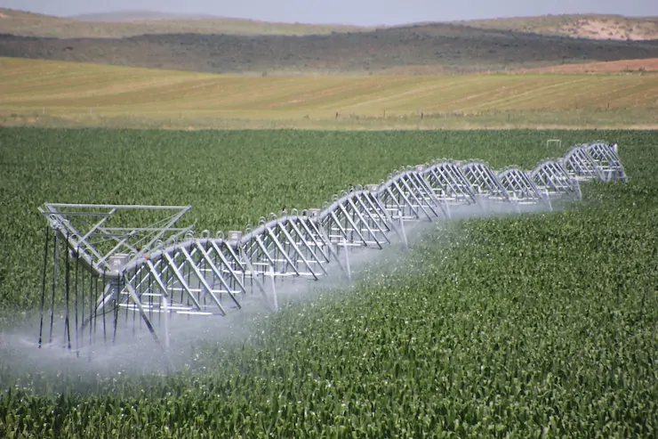
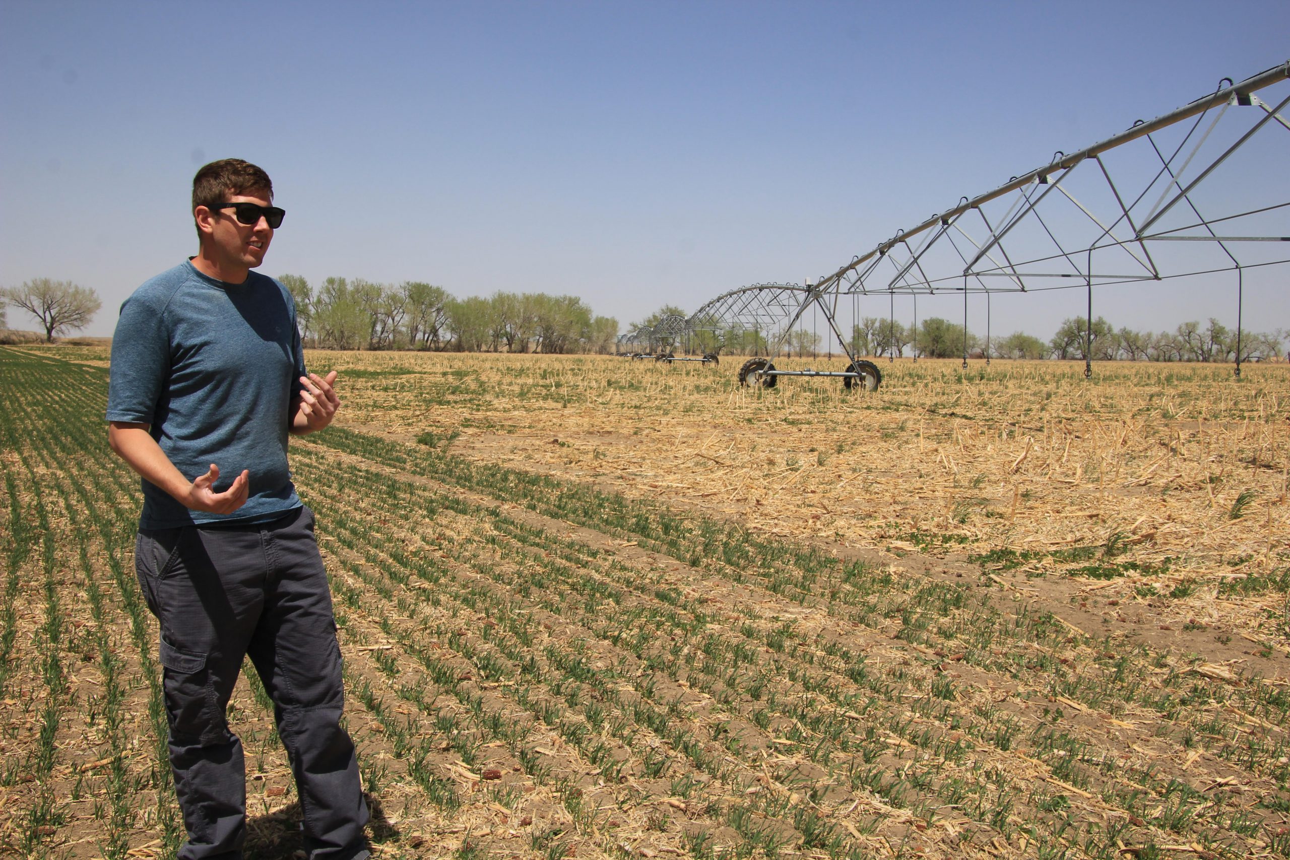
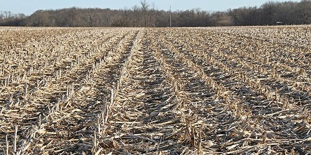
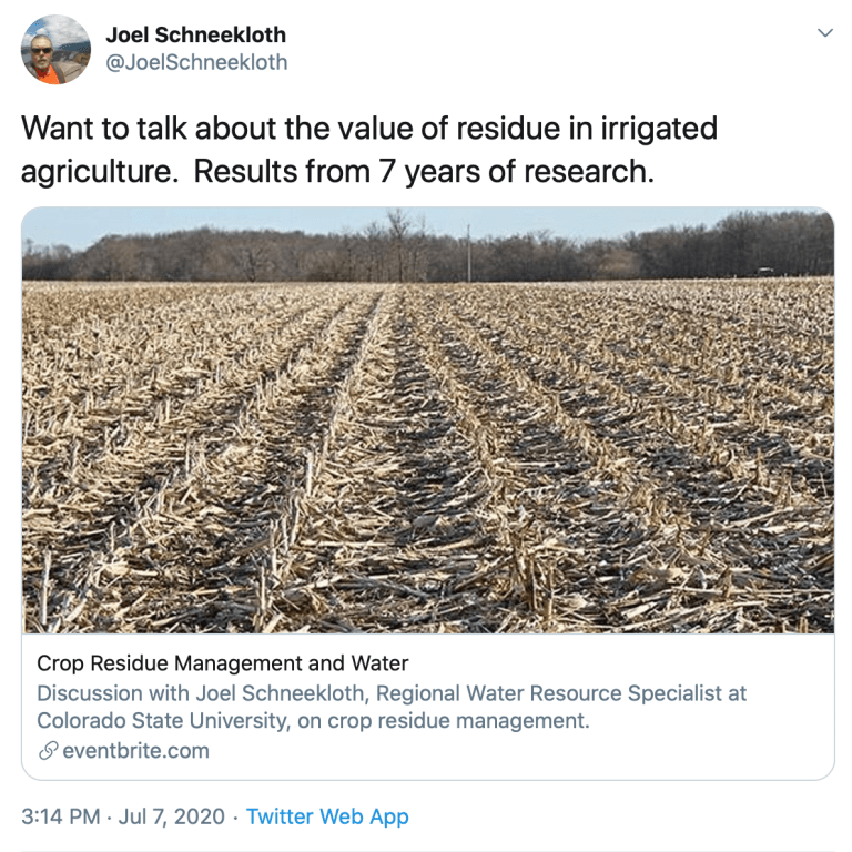
Center pivot south of Holyoke. Photo credit: Allen Best/Big Pivots
Click the link to read the article on the Big Pivots website (Allen Best):
September 18, 2025
Cumulus clouds towering over the Great Plains on Tuesday afternoon inspired visions of Greek gods casting bolts. In McCook, Neb., the storm dumped five inches of rain accompanied by hail that ranged from the size of golf balls to baseballs.
McCook is located along the Republican River, which originates on the eastern plains of Colorado far distant from mountain snows. Despite summer thunderstorms, it’s a dry area with an average annual precipitation of about 17 inches. The water in the river that flows into Nebraska comes almost entirely from the Ogallala Aquifer, much of that water deposited millions of years ago.
In Colorado, the North Fork of the Republican River flows through Yuma. It stormed there on Tuesday night, too, lightning flashing occasionally through the windows. But the storm inside a room at the Yuma County Fairgrounds was of an entirely different sort.
The simple question was how did those farmers who pump water from the underlying Ogallala aquifer wish to tax themselves? For Colorado to honor its compact commitments to Nebraska and hence Kansas, both of them downstream, it has to make changes.
Those who spoke loudest said they did not want to be taxed based on the volumes of water they use. Some questioned the need for any fees. Some questions suggested a denial that any problem exists. Just let us keep pumping the aquifer as we have!
The meeting was the finale of six meetings held across the Republican River Basin in recent weeks. Like the others, it was well attended. At least 75 people showed up, many wearing the cap and blue jeans they had worn earlier in the day while working in their fields of corn and other crops.
In November, directors of the Republican River Water Conservation District must decide exactly how they want to move forward. To stay in compact compliance, the district wants to expand a well field that has allowed them to do so, if sometimes with narrow margins.
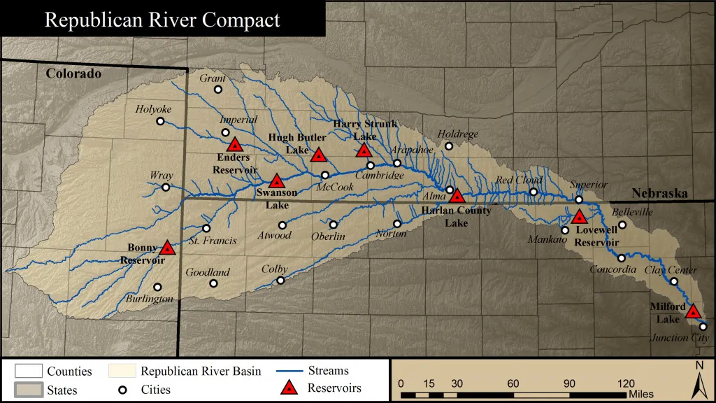
A 1942 compact among Colorado, Nebraska and Kansas specified how much water the upstream states must allow to flow downstream. That wasn’t an issue until the massive application of high-capacity pumps and then center-pivot sprinklers in the 1960 and 1970s allowed farmers to mine the aquifer in the Republican River Basin. In Colorado, more than a million acre-feet of water were pumped in peak years.
This has had the effect of reducing flows in downstream states. Kansas sued Nebraska, and then Nebraska sued Colorado. The case went to the U.S. Supreme Court, as all interstate compacts must.
The upshot is that Colorado agreed to toe the line. The Republican River Water Conservation District was created in 2004 with the principal function of keeping Colorado in compact compliance.
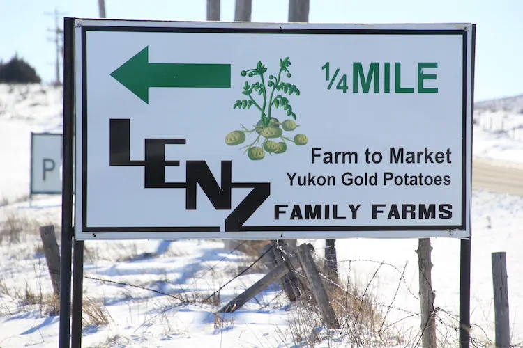
That’s a tall order. Rod Lenz, the president of the board of directors, said that farmers in the district need to figure out how to reduce their pumping to extract an average of 600,000 acre-feet a year. They have averaged 700,000 acre-feet in recent years.
The warming climate has not helped. Drought most definitely does not. In 2022, a hot and dry year, farmers pumped 940,000 acre-feet.
By reducing pumping to 600,000 acre-feet, farmers in the basin will have a longer glide path as they figure out more sustainable ways to farm.
Pumping at current rates will cause some areas to lose water in 25 years, although other areas will have water for many more decades. Yuma lies in one of the more water-flush areas.
“We’re not here to regulate,” said Lenz at a meeting in Joes the prior week. “We’re here to stay in compact compliance.”
That’s a thin distinction but one suggestive of the tricky line being negotiated by directors. Change must occur, but change is rarely welcomed except by babies with soiled diapers.
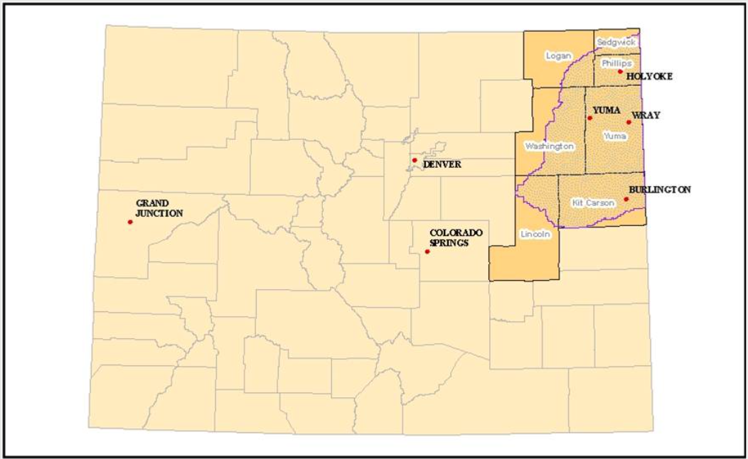
The district’s directors have adopted a two-pronged strategy for keeping Colorado out of the courtroom with Nebraska. One strategy, which was initiated in 2016, involving taking land out of irrigated production. By early 2025, more than 17,000 acres had been removed from irrigation, almost entirely within the river’s south fork area. The Ogallala in that area around Cheyenne Wells, Burlington, and Idalia never was as thick, the reservoir of water amid the underground rocks never as plentiful. In many places, the aquifer has been drained.
The second strategy to ensure compact compliance has been to mine water from north of Wray, where the aquifer has greater quantities of water, to deliver at the Nebraska border to ensure compact compliance. Those wells have produced 98,519 acre-feet in the first 10 years.
All of this has not come cheaply. More than $123 million has been spent by the district so far, a combination of federal and state funds along with assessments by the Republican River district of irrigated lands. Those assessments began at $5 an acre but have elevated to $30 an acre.
At the meeting in Yuma, as they had the week before in Joes, Lenz and other directors outlined their thoughts and choices. Foremost in their current strategy is to continue to pay landowners enough money to take land out of production to achieve the goal of 25,000 acres before the end of 2029. The district has about 8,000 acres to go. Landowners are paid for full or partial retirement of land from cultivated agriculture.
More controversially, they also want to expand the well field that allows water to be pumped and then delivered to Nebraska. They plan eight more wells at an estimated cost of $11 million.
Beyond that, they envision even more wells, elevating the total cost to more than $165 million to keep in compliance. That would allow the farmers now mining the Ogallala to continue to mine it without drastic alteration.
The immediate question is whether to stay with the existing assessment of $30 per acre of land. Another approach would be to adopt a fee, half of it to be based on amounts of land being irrigated and half on the amount of water pumped. The third option is the amount of land being irrigated and a tiered rate based on amount of water used, with those using more water paying more.
These latter two proposals would have the effect of encouraging conservation. Directors say they would keep the district’s budget at $15 million annually. However, it’s not clear what impact expanding the well field will have on that budget.
A show of hands at the Yuma meeting showed little appetite for changes in the fee structure. Some questions from audience members suggested rejection of the need for change. Do you really need this money? And is this expensive expansion of the well field needed? Might just two wells, not eight, suffice?
One speaker even challenged whether Colorado had to comply with the compact.
The short answer is that yes, it must. It’s that or agree to spend considerable money in litigation that would go directly to the U.S. Supreme Court, as it has already twice.
The question beyond that question is what would be the stance of Colorado’s governor and attorney general in 2030 if Colorado were to choose to violate the compact? The state water engineer — an appointee of the governor — has authority to shut down all wells in the basin as necessary to comply. Would the state water engineer do so?
That strategy would be risky, responded Randy Hendrix, the river district’s engineering consultant. Wells could be shut down for multiple years.
A few audience members, however, did acknowledge the difficult challenge. “I want to thank all you guys for the hard work. This is a hard job, hard subject,” said one audience member.
What can be said with certainty is that directors of the district who fielded questions managed to keep their cool in the face of the sometimes hard questions and statements.
At their quarterly meeting in November, directors must figure out how to move forward. Or, as some suggested, just ignoring Nebraska and the state engineer and letting those chips fall where they may.
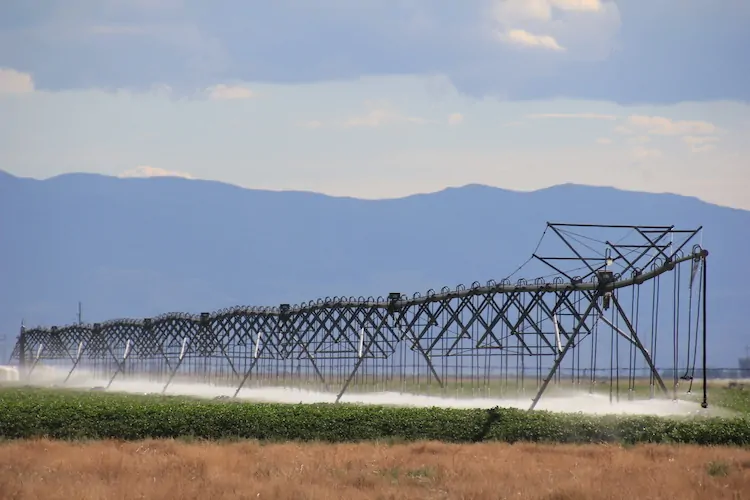
San Luis Valley center pivot August 14, 2022. Photo credit: Allen Best/Big Pivots
Click the link to read the article on the Big Pivots website (Allen Best):
September 12, 2025
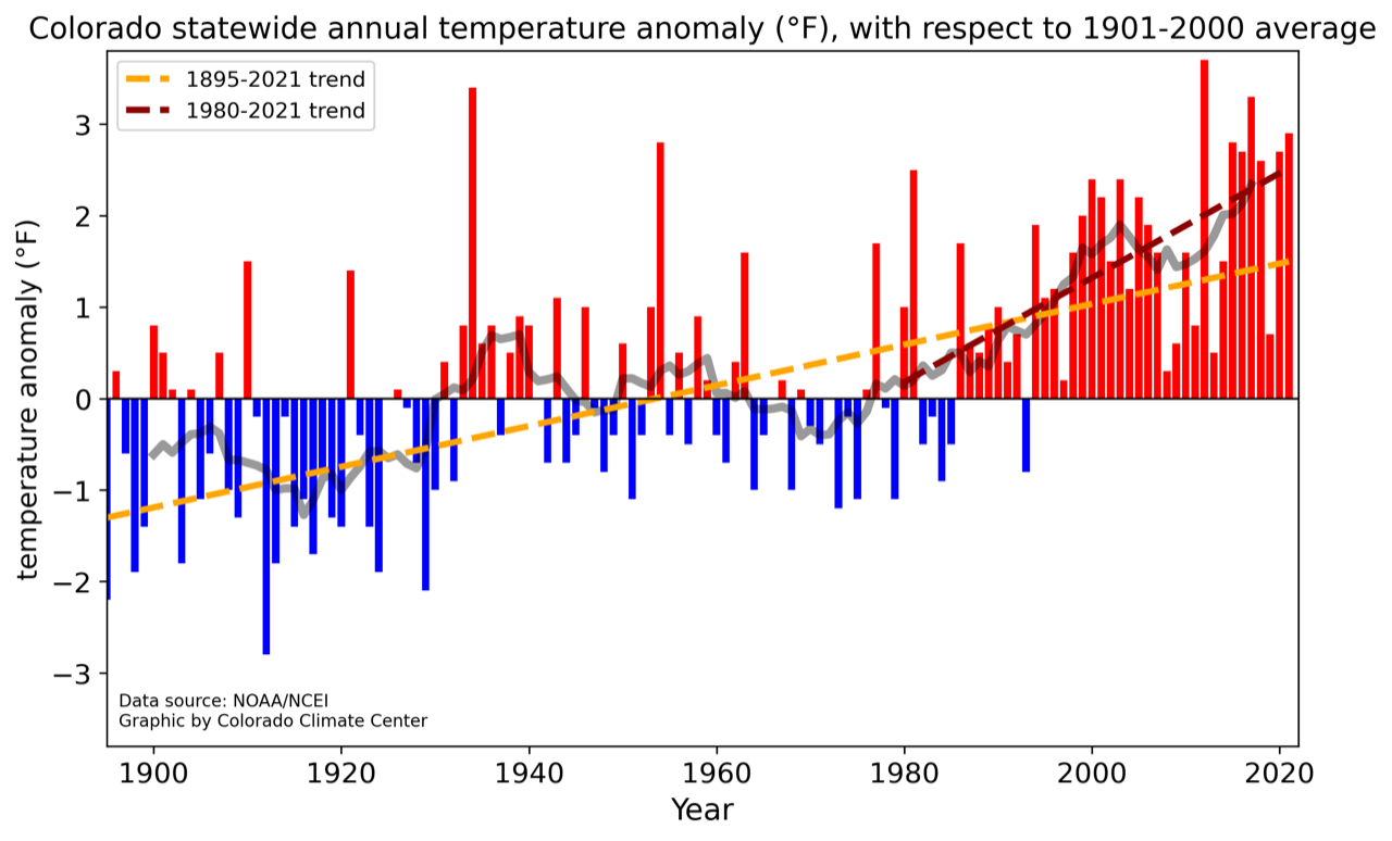
Woes of the Colorado River have justifiably commanded broad attention. The slipping water levels in Lake Powell and other reservoirs provide a compelling argument for changes. How close to the cliff’s edge are we? Very close, says a new report by the Center for Colorado River Studies.
But another cogent — and somewhat related — story lies underfoot in northeastern Colorado. That’s the story of groundwater depletion. There, groundwater in the Republican River Basin has been mined at a furious pace for the last 50 to 60 years.
Much of this water in the Ogallala aquifer that was deposited during several million years will be gone within several generations. In some places it already is. Farmers once supplied by water from underground must now rely upon what falls from the sky.
In the San Luis Valley, unlike the Republican River Basin, aquifers can be replenished somewhat by water that originates from mountain snow via canals from the Rio Grande. The river has been delivering less water, though. It has problems paralleling those of the Colorado River. Changes in the valley’s farming practices have been made, but more will be needed.
In a story commissioned by Headwaters magazine (and republished in serial form at Big Pivots), I also probed mining of Denver Basin aquifers by Parker, Castle Rock and other south-suburban communities.
Those Denver Basin aquifers, like the Ogallala, get little replenishment from mountain snows. Instead of growing corn or potatoes, the water goes to urban needs in one of America’s wealthier areas.
Parker and Castle Rock believe they can tap groundwater far into the future, but to diversify their sources, they have joined hands with farmers in the Sterling area with plans to pump water from the South Platte River before it flows into Nebraska. This pumping will require 2,000 feet of vertical lift across 125 miles, an extraordinary statement of need in its own way.
Like greenhouse gases accumulating in the atmosphere, these underground depletions occur out of sight. Gauges at wellheads tell the local stories, just like the carbon dioxide detector atop Hawaii’s Mauna Loa has told the global story since 1958.
Colorado’s declining groundwater can be seen within a global context. Researchers from institutions in Arizona, California, and elsewhere recently used data from satellites collected during the last two decades. The satellites track water held in glaciers, lakes, and aquifers across the globe. In their study published recently in Science Advances, they report that water originating from groundwater mining now causes more sea level rise than the melting of ice.
“In many places where groundwater is being depleted, it will not be replenished on human timescales,” they wrote. “It is an intergenerational resource that is being poorly managed, if managed at all, by recent generations, at tremendous and exceptionally undervalued cost to future generations. Protecting the world’s groundwater supply is paramount in a warming world and on continents that we now know are drying.”
This global perspective cited several areas of the United States, most prominently California’s Central Valley but also the Ogallala of the Great Plains.
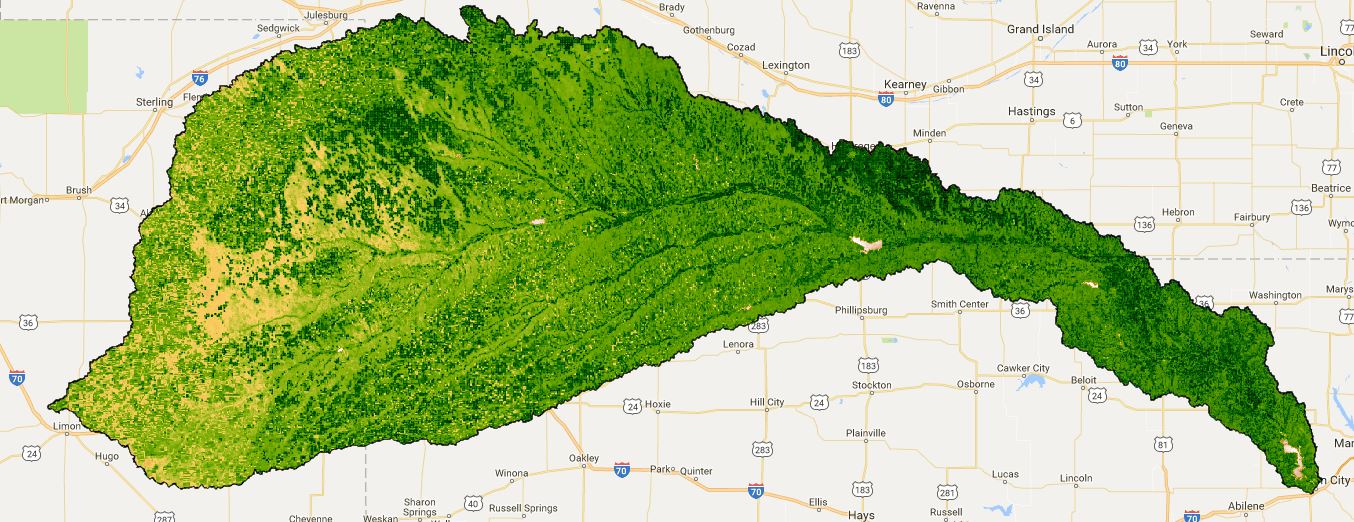
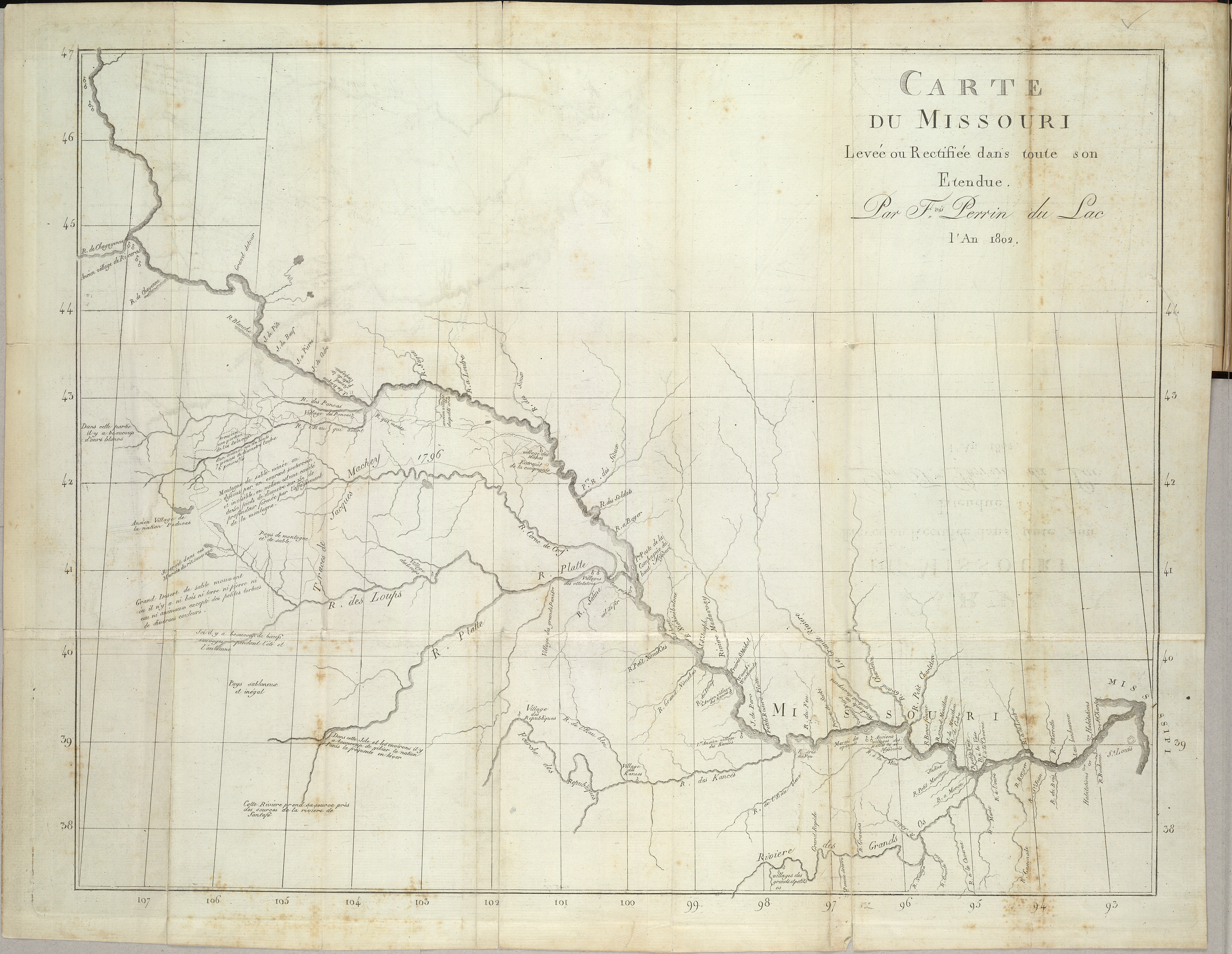
In Colorado, the Ogallala underlies the state’s southeastern corner, but the main component lies in the Republican River Basin. The river was named by French fur trappers in the 1700s, long before the Republican Party was organized. The area within Colorado, if unknown to most of Colorado’s mountain-gawking residents, is only slightly smaller than New Jersey.
A 1943 compact with Nebraska and Kansas has driven Colorado’s recent efforts to slow groundwater mining. The aquifer feeds the Republican River and its tributaries. As such, the depletions reduce flows into down-river states.
Farmers are being paid to remove land from irrigation with a goal of 25,000 acres by 2030 to keep Colorado in compliance. So far, it’s all carrots, no sticks. Colorado is also deliberately mining water north of Wray to send to Nebraska during winter months. This helps keep Colorado in compact compliance. So far, these efforts have cost more than $100 million. The money comes from self-assessments and also state and federal grants and programs.
In some recent years, more than 700,000 acre-feet of water have been drafted from the Ogallala in the Republican River Basin. To put that into perspective, Denver Water distributes an average annual 232,000 acre-feet to a population of 1.5 million.
Hard conversations are underway in the Republican River Basin and in the San Luis Valley, too. They will get harder yet. Sixteen percent of all of Colorado’s water comes from underground.
The Colorado River has big troubles. It’s not alone.
Part II: South Metro cities starting to diversify water sources: Castle Rock and Parker 25 years ago were almost entirely dependent upon groundwater. They are diversifying, and one plan is to import water from far down the South Platte River Valley.
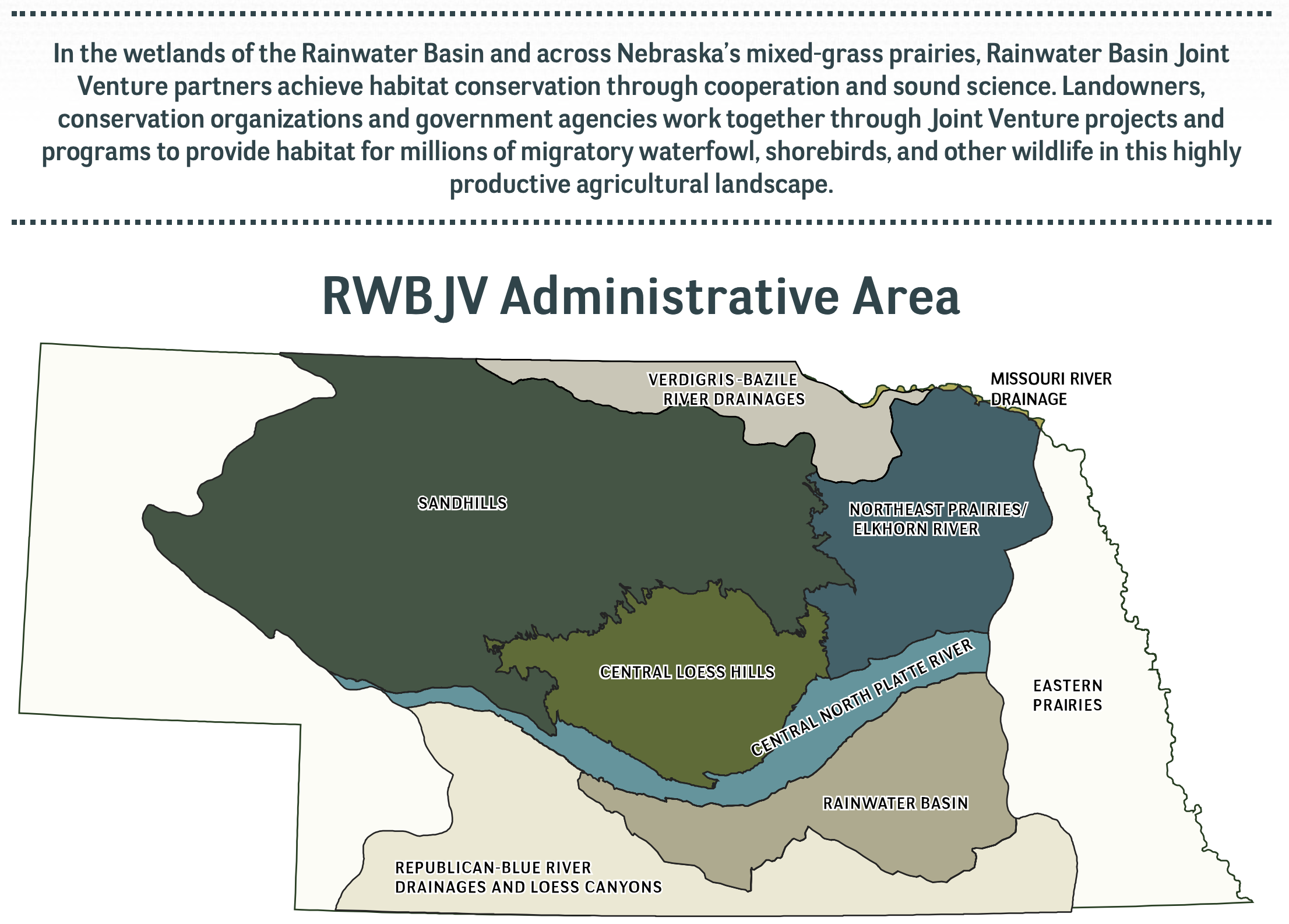
The Republican River basin. The North Fork, South Fork and Arikaree all flow through Yuma County before crossing state lines. Credit: USBR/DOIRio Grande and Pecos River basins. Map credit: By Kmusser – Own work, Elevation data from SRTM, drainage basin from GTOPO [1], U.S. stream from the National Atlas [2], all other features from Vector Map., CC BY-SA 3.0, https://commons.wikimedia.org/w/index.php?curid=11218868Water stored in Colorado’s Denver Basin aquifers, which extend from Greeley to Colorado Springs, and from Golden to the Eastern Plains near Limon, does not naturally recharge from rain and snow and is therefore carefully regulated. Courtesy U.S. Geological Survey.The South Platte River Basin is shaded in yellow. Source: Tom Cech, One World One Water Center, Metropolitan State University of Denver.Map of the Colorado River drainage basin, created using USGS data. By Shannon1 Creative Commons Attribution-Share Alike 4.0
Click the link to read the article on the Big Pivots website (Allen Best):
July 22, 2025
This is the final part of a series about four groundwater basins in Colorado. The story was commissioned by Water Education Colorado and benefited from editing by Caitlin that organization’s staff. It appears in a variant form in the summer 2025 issue of Headwaters magazine.
The San Luis Valley, like the Republican River Basin, has almost no tax base other than irrigated agriculture. “Nearly everything in the valley is somehow related to agriculture. Our hospital, our schools — everything is dependent on agriculture’s existence in the valley,” says Amber Pacheco from her office in Alamosa. From her office in Wray, Deb Daniel has a parallel observation.
What then constitutes sustainability of the water that is the foundation of agriculture or, in the case of Parker, Castle Rock, and other south metro communities, their economic vitality? What decisions should be made now to foster that vitality through the 21st century?
Smuggler Mine back in the day via GregRulon.com
Thoughts about conservation have shifted over time. When Colorado’s gold and silver miners arrived, they had no goal of conserving. They either mined the veins to exhaustion, or it became too costly to continue. In a sense, that has happened in the Republican River Basin. The only limits to this groundwater mining are those triggered by the interstate compact. Because the Republican River and its tributaries get most of their water from aquifers, pumping must be limited — or supplemented.
In the last 20 years, the Republican River Water Conservation District has done some of both. It has or soon will have committed $86 million to pump water from wells expressly to deliver water to the Nebraska state line. One of the directors, Tim Pautler, has called this a strategy of kicking the can down the road. Other directors have started to agree.
“It’s like the clock is ticking when it comes to sustainability,” said Rod Lenz, the board chair, at the board’s quarterly meeting in May 2025. “What more can we do with the tools we have? Do we dare ask for more tools such [as would be delivered by] statute changes? Do we really want all the groundwater districts in the basin to ask the state engineer to reconsider how much we’re allowed to pump, or do we just stay in compliance until we can’t?”
San Luis Valley Groundwater
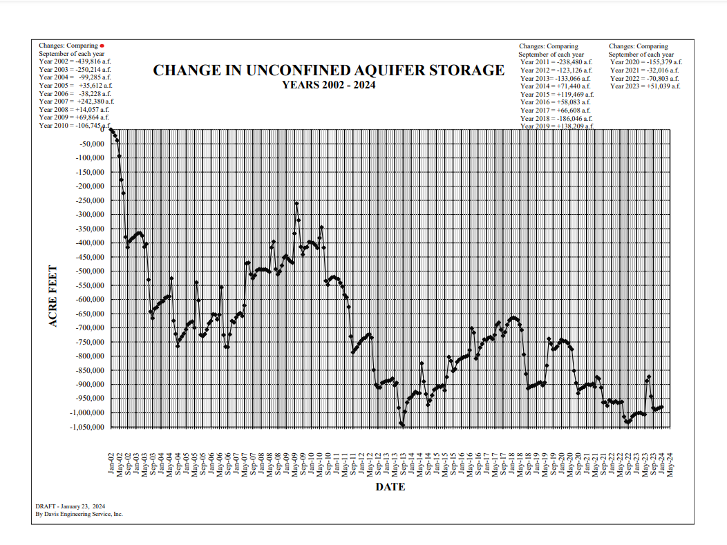
In the San Luis Valley, coming off the century-defining drought of 2002, state legislators went in exactly the opposite direction. They said that the unconfined aquifer was to be managed sustainably. Granted, that’s easier said if you have a major river flowing nearby, even if that river has been hammered hard by the warming, drying climate of the 21st century.
Water stored in Colorado’s Denver Basin aquifers, which extend from Greeley to Colorado Springs, and from Golden to the Eastern Plains near Limon, does not naturally recharge from rain and snow and is therefore carefully regulated. Courtesy U.S. Geological Survey.
The south metro area falls somewhere between these two extremes. State legislators nearly a half-century ago ordered a “slow sip” of the groundwater such as to preserve it for a century. In some places, there seems to be sufficient water to slow sip for another 300 years. In other places, the aquifer might have enough water for a few decades. Some water utilities hope for a completely sustainable water supply in decades ahead. Much work has been done. The harder work lies yet ahead.
What we need are aspirations premised not on entitlement and enrichments solely for today, but instead to build economies and cultures that more comprehensively look several generations ahead. That should be the question in all these meetings, all these court cases, all of these individual actions. Based on what we know and understand today, what should we be doing for the kids, grandkids and their grandkids, too? Are we doing better than kicking the can down the road?
This is the first part of the series from the summer issue of Headwaters Magazine. Click the link to read the series on the Water Education Colorado website. Click the link to read the article on the Big Pivots website (Allen Best):
July 20, 2025
To understand the predicament in the Republican River Basin of eastern Colorado, you need to appreciate the volume of water being hoisted from the underlying High Plains Aquifer. The most important component is the Ogallala.
Farmers and the few small towns in the Republican River Basin average 720,000 acre-feet of withdrawals annually. In one hot and dry year, 2012, they pumped 940,000 acre-feet. As a point of reference, Blue Mesa Reservoir, the largest water body in the state, can hold 947,435 acre-feet.
Groundwater mining cannot be sustained far into the future in many areas of the Republican River Basin. Wells in some areas have not declined while wells in other areas have declined 13 feet during the last decade. Pumping at existing rates cannot be maintained. Within 25 years, about a third of land that’s now irrigated will have no water. In other places, pumps already sputter.
“Sustainable” and “pumping” do not belong in the same sentence in this basin. The water of the Republican River Basin in the High Plains Aquifer accumulated from 18 to 4 million years ago.
Far from the snowmelt of the Rocky Mountains, it is recharged by minimal surface water. Based on studies, the Republican River Compact of Colorado, Nebraska and Kansas assumes that 17% of the water on the surface trickles down through the ground to the aquifers. So, only very slowly is the aquifer recharged. It’s mostly an ancient bank account with now small, almost tiny deposits and fast-and-furious withdrawals.
The Republican River Basin and several other regions of the state rely largely on groundwater. In a 2024 decision, Colorado Supreme Court justices pointed out that it would be difficult to overstate the importance of groundwater given the state’s population and arid climate. The 285,000 wells poked into the earth across the state deliver 18% of Colorado’s water.
The Republican River Basin, the San Luis Valley, and the south metro area of the Denver Basin are all, to varying degrees, rethinking water — both its sources and uses. All three have historically relied heavily on groundwater, and all have made at least limited progress in shifting toward more sustainable groundwater use in the last 20 years. The cities have adopted policies that foster smaller, less water-intensive lawns. They have diversified their sources. Two south-metro water utilities that 20 years ago pulled nearly all their water from wells, today have lessened that dependency to 60% to 65%.
Farmers in the Republican River Basin and San Luis Valley have somewhat different challenges. They have taken action to use less water and to save their communities, but whether those actions match the scale of the challenges they face is another matter. Changes can best be achieved before emergency sirens wail. In the Republican River Basin, some already see a swirl of red lights warning of catastrophe ahead.
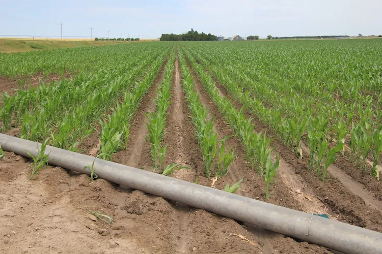
Irrigation pipe and corn crop near Holyoke. Photo credit: Allen Best/Big Pivots
It’s going fast! What needs to be done in the Republican River Basin?
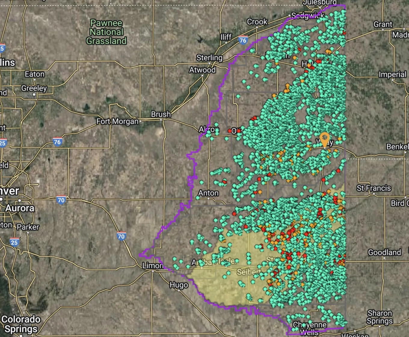
The Republican River Basin consists of 7,000 square miles, an area slightly smaller than New Jersey. It is largely located within a triangle between Julesburg, Limon and Cheyenne Wells. A few businesses cater to travelers but agriculture constitutes nearly all of the basin’s economic foundation.
An average 17 inches of precipitation falls per year across the basin, less in some areas. High-dollar agriculture depends almost entirely upon water drawn from the Ogallala. A 2010 state report found that of the basin’s 600,000 acres then under irrigation, only 1,000 were supplied by surface water. Locals suggest the true number is far, far less.
Dryland farming prevailed until the arrival of high-capacity pumps and rural electrification in the late 1940s. Farmers in the 1950s began converting dryland areas to irrigation, dramatically expanding crop yields. Other farmers arrived to plow hitherto virgin turf. Twice in the 1970s, groundwater extraction exceeded a million acre-feet per year.
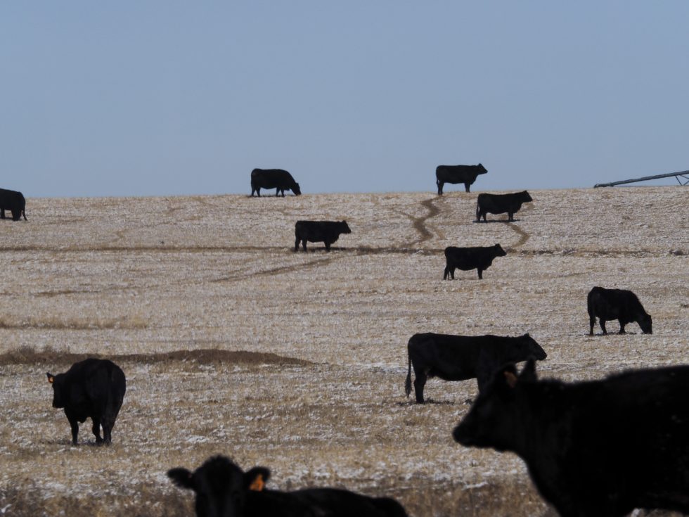
Drafting of groundwater via 5,000 wells today produces a bounty of herbaceous crops. Most end up in the bellies of livestock. Two feedlots near Yuma alone can each hold more than 150,000 cattle and several others can accommodate 75,000. The basin also has three hog farms, several dairies, and an ethanol plant.
Republican River Basin map. Credit: Republican River Compact Administration
In 1942, Colorado, Nebraska and Kansas allocated the waters of the Republican River and its tributaries in an interstate compact. The state engineer in 1973 ordered a moratorium on new wells. The most powerful limitation did not come until 1990. Rules were changed, reducing the allowed rate of depletion, effectively precluding new well permits.
Existing wells, however, were drawing down the aquifers in the Republican River Basin. Kansas in the 1990s complained that it was getting shorted by Nebraska. Nebraska in turn blamed Colorado. A 2002 settlement stipulation among the three states represented a new line in the sand. By whatever means, Colorado had to figure out how to deliver water to the downriver states.
Colorado responded by forming the Republican River Water Conservation District. In effect, the state gave farmers and others in the eight-county district responsibility for figuring out how to comply with the compact. To help achieve compliance, legislators gave the district authority to levy fees on irrigators. The fee, originally $5 per acre, has been boosted twice and is now $30 per acre annually.
The Ogallala is plumbed by many wells in the Republican River Basin within Colorado.
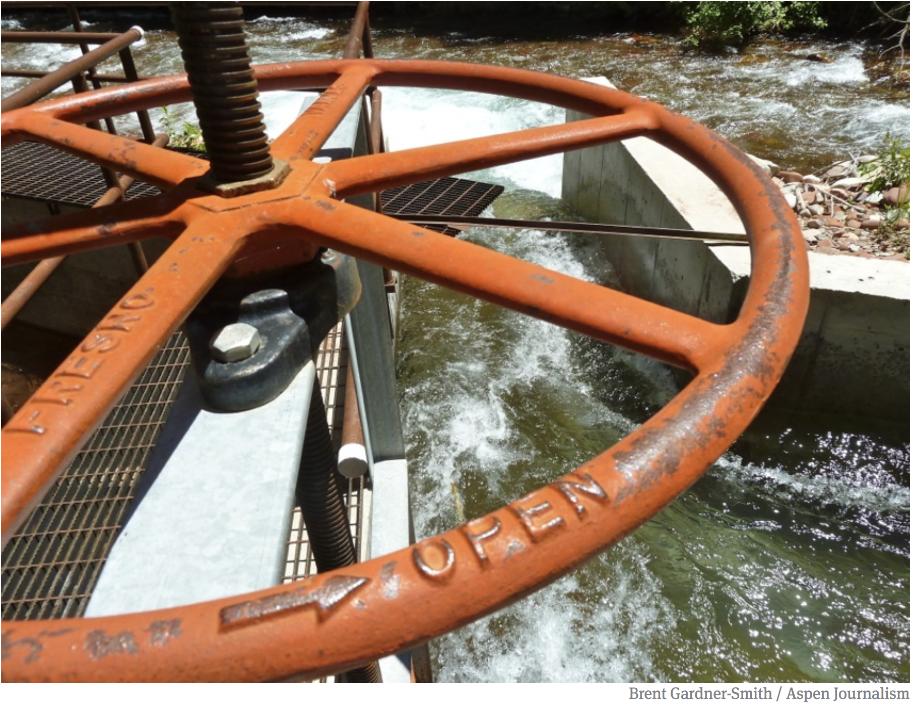
This $15 million in annual revenue is used in several ways. An early project was a pipeline to boost the amount of water flowing into Nebraska. The pipeline carries water from eight wells previously used for irrigation. They had been drilled amid hills with sugar-like sand between Wray and Holyoke in the deepest part of the aquifer. The water from these wells flows 12.6 miles through the pipeline and into the North Fork near the Nebraska border. The wells are pumped from October to April, ensuring minimal loss to evaporation or riverine trees or grasses.
This pipeline, since its completion in 2012, has allowed Colorado to meet its compact delivery requirements. The cost of the wells, pipeline, and water rights was $72 million. Faced with declining production from these wells, the district in 2025 is planning four more wells and 9.5 miles of pipe at an estimated cost of $14 million to deliver what the compact pledges to Nebraska.
With members and staff of the Republican River Water Conservation District looking on, Colorado Gov. Jared Polis signed a bill in May 2023 that allocated $30 million to be used to retire irrigated acreage as necessary to meet a 2029 deadline. Photo/Office of Jared Polis
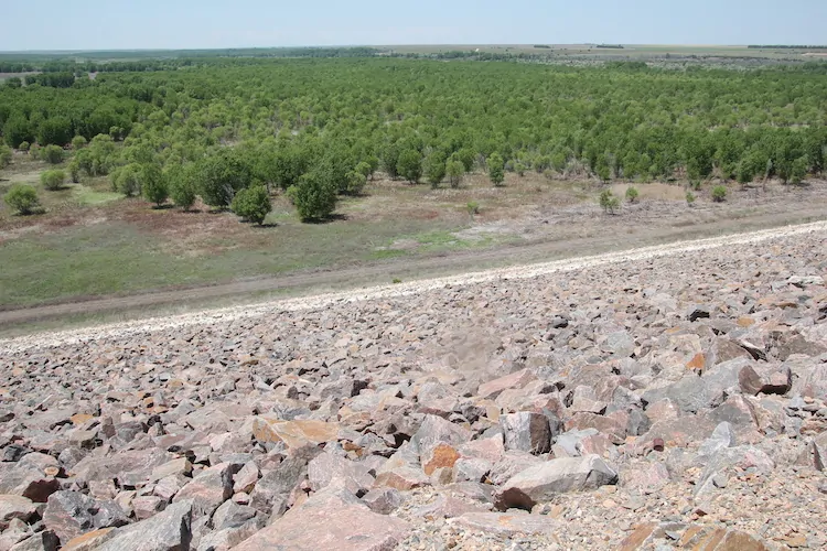
In another move toward compact compliance, Bonny Reservoir, a 165,238 acre-foot impoundment on the South Fork of the Republican, was drained. Prior to the 2011 draining, Bonny had delighted boaters and anglers but lost too much water to evaporation and seepage. Water now flows more efficiently downstream.
More actions were needed to ensure Nebraska and Kansas received their apportioned water. Beginning in 2006, Colorado removed 30,000 to 35,000 acres from irrigation. A multi-state agreement in 2016 specified that Colorado would remove an additional 25,000 acres in the South Fork drainage by 2029. Dick Wolfe, then Colorado’s state engineer, was asked at the time how this was to be done. He paused a moment, then likened it to getting a haircut: a snip here, a snip there.
This snipping of irrigated acreage has been encouraged with financial incentives assembled from pots of local, state and federal funds. The money is delivered via two federal programs: the Conservation Reserve Enhancement Program (CREP), and the Environmental Quality Incentives Program (EQIP). The latter allows farmers to use the land for dryland farming or grazing.
By early 2025, the Republican River Water Conservation District had retired 17,120 of the 25,000 acres as required by the 2016 settlement. It was a milestone, a time for momentary celebration. The harder work lies ahead. Nearly 8,000 additional acres must be retired to meet the December 2029 deadline. If the goal is not met, the state engineer has authority to shut down wells. Nobody wants that, least of all the state engineer. To help sweeten the incentives in 2025, state legislators appropriated $6 million. This adds $750 to the $4,500 per acre paid to farmers participating in CREP and $750 to the $3,500 per acre in EQIP.
By June 2025, Bonny Reservoir had a forest of trees, but the water that had drawn boaters and anglers was drained in 2011. Photo credit: Allen Best/Big Pivots
Using less water is the paramount challenge. This has been accomplished almost exclusively by taking land out of irrigation. There are other ways, too. Today, corn is king, responsible for about 85% of irrigated acres in the basin. It commonly receives 20 to 22 inches of supplemental water. A growing realization of late has been that less can be more. Planting fewer seeds — say 18,000 per acre instead of 30,000 — will save money and require less fertilizer. Fewer seeds will then require only 12 to 14 inches of supplemental water, meaning less pumping and shaving electricity bills. Lower crop yields can counterintuitively produce better profit margins.
Conversations are also underway about water-conserving crop alternatives: milo, millet and wheat, kidney and pinto beans, even black-eyed peas. It’s partly a matter of developing markets. Deb Daniel, the general manager of the district since 2011, has been toying with how to emphasize productivity strategies with the phrase “crop per drop.”
None of this adds up to the scale of the challenge, though.
Above: Most of the water in the Republican River comes from the aquifers, and by Wray, there’s little in the river. Photo credit: Allen Best/Big Pivots
Republican River in Colorado January 2023 near the Nebraska border. During winter, water is pumped from wells north of Wray for delivery into the North Fork of the Republican at the Nebraska state line. Photo credit: Allen Best/Big Pivots
Kenny Helling, a fourth-generation farmer from the Idalia area of Yuma County, believes more is needed than financial incentives to take land out of production. “Continuing to throw money at the problem won’t fix the problem,” he says. Ways must be found to keep land in irrigation, because irrigated land pays more in property taxes. Those taxes are crucial for operating fire departments, schools and other community purposes. “It’s a very big concern to me.”
The answers? Helling sees value in permits specifying reduced volume of pumped water. He would like to see more crop rotation.
Helling was a member of the Republican River Water Conservation District Board of Directors for nine years. He says the district needs other tools. The true authority for limiting pumping belongs to the eight groundwater subdistricts within the basin. They do not use it. Why?
“Everybody on those groundwater management districts are generally irrigators,” says Helling. “Most of them are neighbors. A lot of them go to church together. A lot of them might have kids and grandkids in school together. Nobody wants to make anybody mad. And so, unfortunately, the groundwater management districts do not use all the authority they could to restrict the amount of water used.”
Colorado legislators, he says, need to give the Republican River Water Conservation District more authority. It needs sticks, not just carrots. “We need to use less water.”
Tim Pautler told members of the Colorado Groundwater Commission something similar in May 2025. A dryland farmer from the Stratton area, he has served on the Republican River Water Conservation District’s Board of Directors for 21 years. He says that the board has accomplished almost no basin-wide conservation. It hasn’t figured out how to substantially reduce water use.
Most landowners who have taken advantage of the incentives have been irrigators who have less groundwater available in their wells. Nearly all in the southwestern portion of the basin, where many wells were already sputtering. He says if reduced water use is the goal, the fees charged to farmers must be based on acre-feet of water pumped and not just on irrigated acres.
There’s no pretense of sustainability in the Republican River Basin. The water deposited over millions of years is now being mined. The task is to maximize value of the remaining water, to prolong the availability of the High Plains Aquifer. Few have yet been willing to talk about the gravity of the challenge.
“I hope enough water remains in the hole to sustain society,” says Pautler. “I hope we don’t go completely dry.”
Part II: Entering the 20th century, the Denver metro communities of Castle Rock and Parker were growing fast — and almost entirely reliant upon Denver Basin aquifers. They still are, but they have started diversifying their sources while encouraging conservation of water. You can also download the entire story here in a magazine format.
Perkins County Canal Project Area. Credit: Nebraska Department of Natural Resources
Click the link to read the article on the Colorado Politics website (Marianne Goodland). Here’s an excerpt:
April 7, 2025
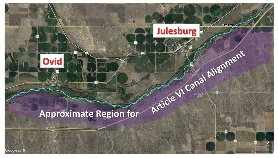
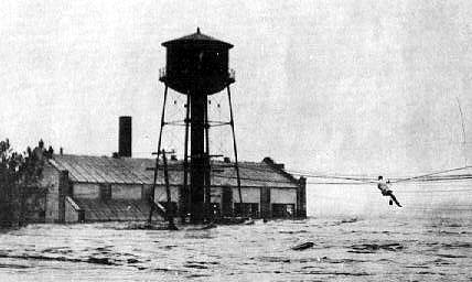
On or around April 17, six landowners in Sedgwick County will face a decision: whether to sell their land to the state of Nebraska for a canal that will be at least partially constructed in Colorado, or face what is likely to be an unprecedented land grab…The history of the proposed canal dates back more than 100 years, to the compact between Colorado and Nebraska regarding water from the South Platte River. Article VI of the compact states that Nebraska can divert 500 cubic feet per second during the non-irrigation season, as well as any additional available flows, into the canal. That non-irrigation season runs from Oct. 15 to April 1…
However, Nebraska claims that Colorado has increased its own diversions and related water uses during the non-irrigation season, leaving Nebraska with no choice but to construct the canal and claim its non-irrigation season water. The canal would start just east of Ovid, in Sedgwick County, and continue into Perkins County, just across the state line in Nebraska. The 1923 compact allows Nebraska to build the canal, using eminent domain, and to seek it in federal court if necessary.
People work on the Perkins County Canal in the 1890s. The project eventually was abandoned due to financial troubles. But remnants are still visible near Julesburg.
Perkins County Historical Society
For one state to grab the land of another is unprecedented, Attorney General Phil Weiser told Colorado Politics earlier this year. While Colorado agreed to the canal in 1923, that’s not how Weiser sees it now. Weiser sent a letter to the Sedgwick County commissioners in January, stating that he is opposed to Nebraska’s potential action. He wrote that he had advised Nebraska’s attorney general that the project would provide little to no benefit to the state of Nebraska. However, if Nebraska moves forward, Colorado will defend its rights, he added.
Perkins canal drawing showing the Colorado portion, courtesy Nebraska Department of Natural Resources.
Farm communities on the Eastern Plains, under the gun to deliver water to Kansas and Nebraska, are poised to permanently retire 17,000 acres of land, with the help of $30 million in state and federal funding.
Creating a balance of water that’s taken from aquifers and water that replenishes aquifers is an important aspect of making sure water will be available when it’s needed. Image from “Getting down to facts: A Visual Guide to Water in the Pinal Active Management Area,” courtesy of Ashley Hullinger and the University of Arizona Water Resources Research Center
From Wray, to Yuma to Burlington, growers are being paid to permanently shut off irrigation wells linked to the Republican River to ensure the vital waterway can deliver enough water to neighbors to the east, as required under the Republican River Compact of 1943.
As of this month, ranchers had already retired 10,000 acres under the program, and the rest will be set aside in coming months.
By 2029, the region must retire an additional 8,000 acres, as required under a compact resolution signed in 2016, for a total of 25,000 acres, according to Deb Daniel, general manager of the Republican River Water Conservation District, which is overseeing the initiative. This is occurring in an area on the south fork of the river.
According to Colorado State University it is one of the largest dry-ups of irrigated agricultural lands in the West.
The dry-up has allowed Colorado to meet a critical deadline with Kansas, demonstrating that it was making progress on the goal.
Colorado’s Republican River Basin. Credit: State of Colorado.
“We did it,” said Daniel. But more work remains.
The 2022 funding came under the American Rescue Plan Act, the COVID-relief program that Congress approved giving states hundreds of millions of dollars to buffer the effects of the pandemic.
Through that program, Colorado lawmakers approved $30 million to the Republican and $30 million to the Rio Grande Basin as well for a similar program.
This year, the Republican Basin will receive another $6 million in state funding to continue paying farmers to permanently shut off wells.
“Agriculture is the economic driver for the northeastern counties of Colorado. This is a difficult situation for the producers,” said Jason Ullmann, state engineer with the Colorado Division of Water Resources. “I know this work hasn’t been easy, and more must be done. I applaud the Republican River Water Conservation District for their major efforts to reach this deadline,” he said in a statement.
A new analysis shows a nearly 30% decline in Colorado’s irrigated lands in the last 25 years, driven in part by the state’s legal obligations to deliver water across state boundaries, as in the Republican Basin. Other factors include declining river flows due to climate change and drought, and the dry-up of farmlands by fast-growing cities.
Daniel said water officials hope they can continue to pay farmers to permanently retire land and to do so in a way that doesn’t cripple the regional economy.
“We need time to let these communities adjust, to adapt to having less irrigated agriculture. As these wells go down, our communities are adjusting, but most of the time, unless they have other industries, the communities just go away,” Daniel said.
Republican River in Colorado January 2023 near the Nebraska border. Photo credit: Allen Best/Big Pivots
Click the link to read the article on the Big Pivots website (Allen Best):
December 23, 2024
10,000 acres in the basin have now been retired from irrigation. But Colorado must remove 15,000 more acres before 2030.
Colorado has achieved a milestone, retiring 10,000 acres from irrigation in the Republican River Basin of northeastern Colorado.
But a much larger, more difficult challenge lies ahead. The state must retire 25,000 acres before 2030 in order to comply with the compact with Nebraska and Kansas governing water in the basin.
The Colorado Division of Water Resources announced on Dec. 20 that Nebraska and Kansas agreed that Colorado has taken the necessary actions to retire the minimum 10,000 acres based on executed contracts and aerial data collected in the summer of 2024.
The compact between the three states was ratified in 1942. Then came the widespread adoption of high-capacity wells followed by center-pivot sprinklers that permitted exploitation of the Ogallala and other aquifers. The aquifers feed into various forks of the Republic River.
Flows in the river subsequently declined. Kansas and Nebraska complained, rolling out the legal sabers. That resulted in formation of the Republican River Water Conservation District in 2004 to address the over-drafting of the aquifer. A resolution between Colorado and its neighbors in 2016 gave Colorado a specific target. It must figure out how to eliminate irrigation from 25,000 acres in the South Fork of the Republican River by the end of 2029.
Wells in the Republican River Basin in Colorado.
Dick Wolfe, then the state water engineer, was asked in September of 2016 how this would be accomplished. He paused a moment, then pretended to have a scissors in his hands, as if a barber, saying “Bit here, a bit there.” And that is what has been happening.
Irrigators in the district contribute to the district on a per-acre basis. The money is used to induce irrigators to end their diversions via the wells.
State legislators in 2023 allocated $30 million to supplement the district’s self-generated funds to sweeten the pot. The Colorado Water Conservation Board earlier this year added another $6 million.
The map below shows the location of wells in the district. It mostly lies between Interstates 70 and 76.
Some parts of the aquifer, mostly in the southern parts, ceased to have sufficient water for pumping. At a meeting this year in Wray, directors of the conservation district were told that even in the better areas along the North Fork of the River, in the Yuma and Wray areas, water levels have been dropping a foot and a half a year.
There is some agreement among directors that stepped-up action must be taken in order to meet the 2029 deadline for retirement. They will take up that discussion at a February meeting.
Colorado has officially reached the milestone of retiring more than 10,000 acres of farmland from irrigation in the southern Republican River basin. These efforts are necessary to stay in compliance with the Republican River Compact with Kansas and Nebraska.
Depleted groundwater in the Republican River Basin has impacted how much surface water flows east. To remedy this, the Republican River Compact Administration (“RRCA”) adopted a resolution in 2016 to retire 10,000 acres in this part of the basin by 2024.
An additional 15,000 acres need to be retired by December 31, 2029. Colorado is already well on its way to meeting this second milestone, with nearly 7,000 additional acres under contract for retirement.
“Agriculture is the economic driver for the northeastern counties of Colorado. This is a difficult situation for the producers,” said Jason Ullmann, State Engineer with the Colorado Division of Water Resources. “I know this work hasn’t been easy, and more must be done. I applaud the Republican River Water Conservation District for their major efforts to reach this deadline.”
Colorado provided Kansas and Nebraska with the executed contracts and aerial data collected in the summer of 2024. Kansas and Nebraska agreed that Colorado has taken the necessary actions to retire at least 10,000 acres.
“By working together with the State of Colorado, the Republican River Water Conservation District continues to make great strides in complying with the ongoing requirements imposed by the 2016 Republican River Compact Administration Resolution,” said Deb Daniel, general manager of the Republican River Water Conservation District. “The RRWCD continues, with financial support from Colorado, to provide funding to compensate well owners who are willing to voluntarily retire a portion of their irrigated acres to ensure that Colorado and the Republican Basin achieve and maintain compliance with the compact.”
Earlier this year, the Colorado Water Conservation Board approved $6 million to be included in the proposed 2025 CWCB projects bill to support efforts to retire additional acres in the Republican River basin. In 2022, the Colorado state legislature unanimously approved $30 million in the pursuit of retiring the required irrigated acres. The CWCB administers those funds, which were awarded through Senate Bill 22-028.
Corn in Baca County. Photo credit: Allen Best/Big Pivots
Click the link to read the article on the Big Pivots website (Allen Best):
Unanimous votes in the Colorado Legislature are rare, but they do happen. Consider HB24-1435, the funding for the Colorado Water Conservation Board projects.
The big duffle bag of funding for various projects was approved 13-0 by the Senate Water and Agriculture Resources Committee. It had bipartisan sponsors, including Rep. Marc Catlin, a former water district official from Montrose.
“Colorado has been a leader in water for a long, long time, and this is bill is an opportunity for us to stay in that leadership position,” said Catlin, a Republican and a co-sponsor.
“This is one of my favorite bills,” said Rep. Karen McCormick, a Democrat from Longmont and former veterinarian. She is also a co-sponsor.
This historical photo shows the penstocks of the Shoshone power plant above the Colorado River. A coalition led by the Colorado River District is seeking to purchase the water rights associated with the plant. Credit: Library of Congress photo
The bill has some very big-ticket items, including $20 million for the Shoshone power plant agreement between Western Slope interests and Public Service Co. of Colorado, better known by its parent company, Xcel Energy. Andy Mueller, the general manager of the Glenwood Springs-based Colorado River District, called the effort to keep the water in the river “incredibly important” to those who make a living in the Colorado River Basin.
This map shows the 15-mile reach of the Colorado River near Grand Junction, home to four species of endangered fish. Map credit: CWCB
Mueller also pointed out that keeping water in the river will benefit of four endangered species of fish that inhabit what is called the 15-mile stretch of the Colorado River near Grand Junction.
Another $2 million was appropriated for the turf-replacement program in cities, a program first funded in 2022. Another mid-range item is telemetry for Snotel sites, to keep track of snow depths, the better to predict runoff. It is to get $1.8 million.
Among the smallest items in the budget is a big one for Baca County, in Colorado’s southeast corner. The bill, if adopted, would provide the Colorado Water Conservation Board with $250,000 to be used to evaluate the remaining water in aquifers underlying southeastern Colorado. There, near the communities of Springfield and Walsh, some wells long ago exhausted the Ogallala aquifer and have gone deeper into lower aquifers, in a few cases exhausting those, too. Farmers in other areas continue to pump with only modest declines.
What exactly is the status of the underground water there? How many more decades can the agricultural economy dependent upon water from the aquifers continue? The area is well aside from the Arkansas River or other sources of snowmelt.
A study by the McLaughlin Group in 2002 delivered numbers that are sobering. Wes McKinley, a former state legislator from Walsh, at a meeting in February covered by the Plainsman Herald of Springfield, said the McLaughlin study numbers show that 84% of the water has been extracted. That study suggested 50-some years of water remaining. If correct, that leaves 34 years of water today.
Tim Hume, the area’s representation on the Colorado Groundwater Commission, has emphasized that he believes this new study will be needed to accurately determine how water should be managed.
How soon will this study proceed? asked Rep. Ty Winter, a Republican from Trinidad who represents southeastern Colorado. Tracy Kosloff, the deputy director of the Colorado Division of Water Resources, answered that the technical analysis should begin sometime after July. “I would think it is reasonable to finish it up by the end of 2025, but that is just an educated guess.”
She said the state would work with the Baca County community to come up with a common goal and direction “about how they want to manage their resources.”
Unlike the Republican River area of northeastern Colorado, where farmers also have been plunging wells into the Ogallala and other aquifers, this area of southeastern Colorado has no native river. In the Republican Basin, Colorado is trying to remove 25,000 acres from irrigation by the end of 2029 in order to leave more water to move into the Republican River. See story. A similar proposition is underway in the San Luis Valley, where farmers have also extensively tapped the underground aquifers that are tributary to the Rio Grande. See story.
San Luis Valley Groundwater
The closest to critical questioning of the bill came from Rep. Richard Holtorf, a Republican who represents many of the farming counties of northeastern Colorado. He questioned the $2 million allocated to the Office of the Attorney General.
He was told that $1 million of that constantly replenishing fund is allocated to the Colorado River, $110,000 for the Republican River, $459,000 for the Rio Grande, $35,000 for the Arkansas and $200,000 for the South Platte.
Then there’s the litigation with Nebraska about the proposed ditch that would begin in Colorado near Julesburg but deliver water to Nebraska’s Perkins County. Colorado hotly disputes that plan.
Lauren Ris, the director of the Colorado Water Conservation Board, said Colorado is “very confident in our legal strategy.”
Holtorf also noted that the severance tax provides 25% of the funding for the water operations. The severance tax comes from fossil fuel development. As Colorado moves to renewable energy, “what happens to this Colorado water if we kill the goose that lays the golden egg?”
Ris replied said future declines in the severance tax is a conversation underway among many agencies in Colorado state government.
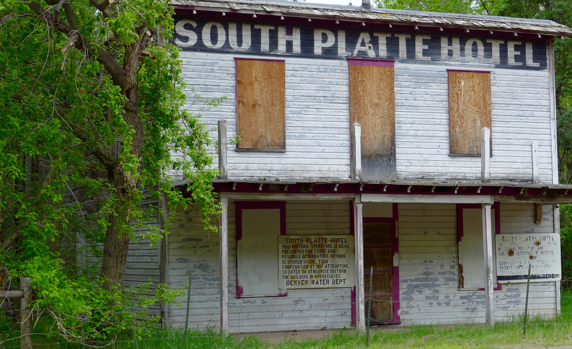
The South Platte Hotel building that sits at the Two Forks site, where the North and South forks of the South Platte River come together. Photo: Brent Gardner-Smith/Aspen Journalism
The budget, which is not yet finalized, includes funding for non-lethal wolf deterrence, water litigation and wildlife management. The six-member Joint Budget Committee, which writes the state budget, settled on a $40.6 billion budget that would take effect July 1…
Water
The proposed budget also includes about $300,000 for two additional full-time employees in the Department of Law to help secure the state’s water interests…Colorado is part of nine interstate water compacts, one international treaty, two U.S. Supreme Court decrees and one interstate agreement.
“As climate change and population growth continue to impact Colorado’s water obligations, the DOL’s defense of Colorado’s water rights is more critical than ever,” according to the document.
One of the new employees, a policy analyst, will monitor government regulations and neighboring states’ activities on water policy. The other position will “bolster the representation and litigation support of the DOL across the various river basins,” support the state’s efforts to negotiate Colorado’s water and compact positions and communicate with the state’s significant water interests.
Click the link to read the article on The Denver Post website (Elise Schmelzer). Here’s an excerpt:
March 3, 2024
For decades, farmers in the Republican River basin have pumped water from the underground Ogallala Aquifer to grow wheat, beans, corn, potatoes, and feed for cattle and hogs. But the water is running out. Flows in the Republican River system are shrinking as the aquifer depletes, making it harder for Colorado to send enough water downstream to the east to fulfill its agreements with Kansas and Nebraska. To meet its obligations, Colorado is legally required to stop irrigating 25,000 acres in the southern part of the basin by the end of 2029 — more than a quarter of all irrigated acreage in that area. If the mandate is not met, state water officials say they will turn off wells for all 540,000 irrigated acres in the broader swath of the state that’s in the river basin, a move that would devastate the region’s economy and way of life…
With wells cut off, farms wouldn’t be able to grow crucial crops that feed Colorado and the wider region. The companies that sell farming supplies, such as seed, tractors and sprinklers, would lose massive amounts of business…Less local income would mean fewer meals at local restaurants in the plains towns and trips to the movie theater or bowling alley. Tax revenue would fall, potentially impacting schools and emergency and social services. Without irrigation, land values would drop — giving farmers less collateral for the loans they depend on to begin each season.
“What’s frightening about it is that it’s really an existential issue for those living in that region,” said Jordan Suter, a Colorado State University professor tasked with examining the economic fallout from that scenario. “With good reason. If irrigated production goes away, the area can’t really support a large population.”
Groundwater from the aquifer makes irrigated farming possible across a large part of Colorado’s Eastern Plains that spans about 7,000 square miles across eight counties — an area the size of New Jersey. In 2022, the counties produced more than $2.6 billion worth of agricultural products, according to the U.S. Department of Agriculture’s farm census. The state has made some progress, but even if it meets the 25,000-acre goal, the aquifer’s water level is still declining.
Kansas Geological Survey at the University of Kansas is embarking on a two-year study of playas that hold water during wet periods in Scott County and elsewhere to better understand their role in recharge of the underground Ogallala aquifer. (Bill Johnson/Kansas Geological Survey)
Aerial view of irrigated and non-irrigated fields in eastern Colorado. Photo by Bill Cotton, Colorado State UniversityOgallala Aquifer. Credit: Big PivotsRepublican River Basin overlaying the Ogallala Aquifer. Graphic credit: Deb Daniel/RRWCDThe Ogallala aquifer, also referred to as the High Plains aquifer. Source: National Oceanic and Atmospheric AdminstrationCenter pivot sprinklers in the Arikaree River basin to irrigate corn. Each sprinkler is supplied by deep wells drilled into the High Plains (Ogallala) aquifer.Kansas Aqueduct route via Circle of BluePlots of land in Finney County, Kansas, utilize irrigation water from the High Plains Aquifer. Credit: NASA via the University of KansasHistoric photo of the High Plains in Haskell County, Kansas, showing a treeless semi-arid grassland and a buffalo wallow or circular depression in the level surface. (Photo by W.D. Johnson, 1897) High Plains in eastern Colorado. Photo credit Bob Berwyn.Republican River in Colorado January 2023 near the Nebraska border. Photo credit: Allen Best/Big PivotsThe Republican River basin. The North Fork, South Fork and Arikaree all flow through Yuma County before crossing state lines. Credit: USBR/DOIKansas River Basin including the Republican River watershed. Map credit: By Kmusser – Self-made, based on USGS data., CC BY-SA 3.0, https://commons.wikimedia.org/w/index.php?curid=4390886The Republican River’s South Fork near Hale, Colorado, with the region’s seemingly endless fields. Credit: Wikimedia Commons/Jeffrey BeallSouth Fork of the Republican RiverNorth Fork Republican River via the National Science Foundation.Republican River Basin by District
Hundreds of growers in Colorado’s San Luis Valley could see their water costs nearly quadruple under a new plan designed to slash agricultural water use in the drought-strapped region and deflect a potential legal crisis on the Rio Grande.
A new rule approved by the area’s largest irrigation district, known as Subdistrict 1, and the Alamosa-based Rio Grande Water Conservation District, sets fees charged to pump water from a severely depleted underground aquifer at $500 an acre-foot, up from $150 an acre-foot. The new program could begin as early as 2026 if the fees survive a court challenge.
“It’s draconian and it hurts,” said Sen. Cleave Simpson, a Republican from Alamosa who is also general manager of the Rio Grande water district.
The region, home to one of the nation’s largest potato economies, has relied for more than 70 years on water from an aquifer that is intimately tied to the Rio Grande. The river begins high in the San Juan mountains above the valley floor.
Both the river and the aquifer are supplied by melting mountain snows, but a relentless multi-year drought has shrunk annual snowpacks so much that neither the river nor the aquifer have been able to recover their once bountiful supplies.
And that’s a problem. Under the Rio Grande Compact of 1938, Colorado is required to deliver enough water downstream to satisfy New Mexico and Texas. If the aquifer falls too low, it will endanger the river’s supplies and push Colorado out of compliance. Such a situation could trigger lawsuits and cost the state tens of millions of dollars in legal fees.
Subdistrict 1 has set state-approved goals to comply with the compact. Within seven years, it must find a way to restore hundreds of thousands of acre-feet of water to the aquifer, a difficult task.
Rio Grande River, CO | Photo By Sinjin Eberle
An acre-foot equals nearly 326,000 gallons of water, or enough to cover an acre of land with water a foot deep.
The specter of an interstate water fight is creating enormous pressure to reorganize the valley’s farming communities in a way that will allow them to use less water, grow fewer potatoes, and still have a healthy economy.
For more than a decade, valley water users have been working to reduce water use and stabilize the aquifer. Many have already started experimenting with ways to grow potatoes with less water by improving soil health, and to find new crops, such as quinoa, that may also prove to be profitable.
But the pumping plans, considered innovative by water experts, haven’t been enough to stop the decline in aquifer levels. The Rio Grande Basin is consistently one of the driest in the state, generating too little water to make up for drought conditions and restore the aquifer after decades of over pumping.
With the new fees, the region will likely have some of the highest agricultural water costs in the state, said Craig Cotten, who oversees the Rio Grande River Basin for Colorado’s Division of Water Resources.
Perhaps not as high as water in the Colorado-Big Thompson Project on the northern Front Range, where cities and developers and some growers pay thousands of dollars to buy an acre-foot of water.
Still it is much higher than San Luis Valley growers and others have paid historically. Fees at one time were just $75 an acre-foot, eventually reaching $150 an acre-foot. The prospect of the fee skyrocketing to $500 is shocking.
“That is high,” said Brett Bovee, president of WestWater Research, a consulting firm specializing in water economics and valuations. Typically such fees across the state have been in the $50 to $100 range, he said.
But Bovee said the water district is taking constructive action while giving growers opportunities to find their own solutions to the water shortage. “It’s putting the decision-making power into the hands of growers and landowners, rather than saying ‘everybody take one-third of your land out of production.’”
Third hay cutting 2021 in Subdistrict 1 area of San Luis Valley. Photo credit: Chris Lopez
Subdistrict 1 is the oldest and largest of a group of irrigation districts in the valley, according to Cotten. Its $500 fee has triggered a lawsuit by some growers, who believe the district is applying the new fees unfairly.
“The responsibility for achieving a sustainable water supply is to be borne proportionately based on (growers’) past, present and future usage,” Brad Grasmick, a water attorney representing San Luis Valley growers in the Sustainable Water Augmentation Group and the Northeast Water Users Association, said, referring to state water laws. “But we believe the responsibility is being disproportionately applied to our wells.”
Those growers are now trying to create their own irrigation district and they are suing to stop the new fee.
“I think that more land retirement and more reduction in well pumping is needed and that is what my group is trying to do,” Grasmick said. “No one wants to see the aquifer diminish and continue to shrink. If everybody can do their part to cut back and make that happen, that is the way forward. My guys just want to see the proportionality adhered to.”
To date, tens of millions of dollars have been raised and spent to retire wells in the San Luis Valley, with Subdistrict 1 raising $70 million in the last decade, according to Simpson. And in 2022 state lawmakers approved another $30 million to retire more wells.
Lawmakers are closely monitoring these efforts to reduce water use while protecting growers.
Sen. Byron Pelton, a Republican from Sterling, said the combined money that is going to the Rio Grande and Republican basins is critical. But the potential for legal battles, he said, is concerning.
“Agriculture is key in our communities,” Pelton said. “But the biggest thing is that we have to stay within our compacts. Sometimes you’re backed into a corner and that is just the way it has to be. I hate it, but we have to stay in compliance.”
How much irrigated land will be lost as wells are retired isn’t clear yet. Simpson said growers who have access to surface supplies in the Rio Grande will still be able to irrigate even without as many wells or as much water, but the land will likely produce less and farms may become less profitable.
And it will take more than sky-high pumping fees to solve the problem, officials said. The Division of Water Resources has also created another water-saving rule in Subdistrict 1 that will force growers to replace one-for-one the water they take out of the aquifer, instead of allowing them to simply pay more to pump more.
Cotten said the hope is that the higher fees combined with the new one-for-one rule will reduce pumping enough to save the aquifer and the ag economy.
Valley growers are already shifting production and changing crops, said James Ehrlich, executive director of the Colorado Potato Administrative Committee in Monte Vista, an agency involved in overseeing and marketing the region’s potato crops.
“There are a lot of creative things going on down here,” Ehrlich said. “But we have to farm less and learn to survive as a community together. And Mother Nature has not helped us out. We’ve stabilized but we can’t gain back what (state and local water officials) want us to gain back. It is just not going to happen.”
More by Jerd SmithJerd Smith is editor of Fresh Water News. She can be reached at 720-398-6474, via email at jerd@wateredco.org or @jerd_smith.
Fund will retire approximately 11,296 acre-feet of water
When Colorado Senate Bill 28 was adopted during the 2022 legislative session, it created the Groundwater Compact Compliance Fund with $30 million earmarked for irrigators in the Upper Rio Grande Basin.
The state money derived from Colorado’s share of federal COVID dollars that came through the American Rescue Plan Act would serve to incentivize local farmers to permanently retire more groundwater wells. Doing so would further reduce groundwater pumping and translate to fewer irrigated acres in the Valley as a whole.
Seven months after opening applications to the fund, the Rio Grande Water Conservation District has enough contracts to spend nearly the entirety of the $30 million. The contracts represent the full retirement of approximately 34 crop circles and partial restrictions on 28 circles, according to an accounting from the Rio Grande Water Conservation District.
When it’s all said and done, the $30 million will have paid for the retirement of approximately 11,296 acre-feet of water. An acre-foot represents around 326,000 gallons, or enough water to cover an acre of land.
Each application submitted to the Groundwater Compact Compliance Fund was reviewed by the Rio Grande Water Conservation District and Colorado Division of Water Resources. So far six applications representing $4,772,204 have been closed and the RGWCD now owns those water rights, according to deputy general manager Amber Pacheco.
The remaining applications have to be approved or rejected by March 31.
The senate bill also directed $30 million to sustainability efforts on the Republican River Basin in the eastern plains. Like the Rio Grande Water Conservation District, the Republican River Water Conservation District has been successful in administering the program, Pacheco said.
“We’ve been pretty successful,” she said at the Jan. 16 board meeting of the Rio Grande Water Conservation District. “It’s pretty shocking that in six months that amount of money was obligated.”
A small amount of funding will likely remain after current applications are all reviewed, Pacheco said.
The RGWCD received a total of 27 applications. Here’s a breakdown of applications by subdistrict. The applications represent 11,296 acre-feet of past annual withdrawals that would be retired.
Applications total approximately $29,000,000
14 applications in Subdistrict 1* – $11,700,000 2 applications in Subdistrict 3* – $1,200,000 1 application in Subdistrict 4 – $500,000 4 applications in Subdistrict 5 – $5,100,000 2 applications in Subdistrict 6 – $1,300,000 4 applications in Subdistrict 7 (Trinchera Subdistrict) – $9,300,000
*SD1 and SD3 both offered some type of incentive on top of the SB28 program.
Rio Grande and Pecos River basins. Map credit: By Kmusser – Own work, Elevation data from SRTM, drainage basin from GTOPO [1], U.S. stream from the National Atlas [2], all other features from Vector Map., CC BY-SA 3.0, https://commons.wikimedia.org/w/index.php?curid=11218868
State Engineer Kevin Rein is retiring at year’s end and agreed to join The Valley Pod podcast for an interview with host Chris Lopez before he departs. We’re calling it an exit interview.
In it, Rein talks about the importance of bringing sustainability to the unconfined aquifer of the Rio Grande Basin, how the economic future of the San Luis Valley and its agricultural industry is at stake without a sustainable aquifer system, the unique nature of the Rio Grande compared to the Colorado River Basin and others, and the urgency of achieving sustainability in the face of prolonged drought and climate change.
“I wish there was enough water for everybody, but we developed agricultural and municipal uses in a state that is largely a desert and it often has an abundance for a couple months out of the year,” Rein said. “I think it’s good for us to at least feel comfortable that we have that structure in place. But the other thing we need to know, as I alluded to, is that that structure is going to cause us to make difficult decisions, especially as we see climate change, the effects of climate change reducing our water supply, and we see our demands grow.”
Here’s an edited version of the conversation. The full Valley Pod episode is here.
ALAMOSA CITIZEN: Thank you again for giving us some of your time as you exit. And again, congratulations on your retirement. Is the stress of the job starting to subside?
KEVIN REIN: No. The stress, if we can call it that, is not subsiding at all. This trepidation that I face with the idea of retirement and ending a job that I really love doing, weighs pretty heavily on me and wanting to get in every last bit of good work I can do. That’s weighing on me. Yes. Yeah, it’s very important for me to try to finish this. We’re doing as much as I can.
Rio Grande and Pecos River basins. Map credit: By Kmusser – Own work, Elevation data from SRTM, drainage basin from GTOPO [1], U.S. stream from the National Atlas [2], all other features from Vector Map., CC BY-SA 3.0, https://commons.wikimedia.org/w/index.php?curid=11218868
AC: We want to start with some local issues with you of the Rio Grande Basin and then stretch more into the role of the state engineer for Colorado, if you don’t mind. First, can you sum up the importance of the upcoming year 2024 and the influence upcoming water court trials will have on the Rio Grande Basin? And we’re thinking specifically of the water trial around Subdistrict 1 Plan of Water Management, the alternative plan for operating in that particular subdistrict with the Sustainable Water Augmentation Group court filing, and then the idea of the U.S. Supreme Court weighing in on a new settlement between Texas, New Mexico and Colorado when it comes to the Rio Grande Compact. 2024 seems like a significant year in water court.
REIN: It’s going to be very significant that affects the people in the Valley to greater or lesser degrees depending on those three items that you just mentioned. And so that is critical. And Chris, I’ll apologize to you and the listeners that I’m going to be very cautious about my comments on these because of the legal implications and the fact that it’s really active litigation in three areas and regarding the lawsuit on the Rio Grande Compact with Texas and New Mexico. And then as you mentioned the United States, I will probably not say much at all about that because the facts are there and I don’t want to step in front of our good legal staff and say something that is not quite true to the case in terms of the legal implications of what’s going on. But when it comes to SWAG and that case and the groundwater management plan containing the plan of water management for Subdistrict 1, those are very important issues. And I will admit that I’m going to be a little guarded in my comments about those two because pardon me, as you know, the SWAG case was dismissed, but they have re-filed and we may see that play out in a similar fashion. And without saying too much about that and the groundwater management plan for the subdistrict, from my perspective as a state engineer, there’s one critical aspect of that for both cases and that is the sustainability of the unconfined aquifer. As we know, that’s a difficult component of groundwater management in the Valley because we have a statutorily required sustainability objective. And that has found its way into the rules and into the groundwater management plan for the subdistrict. And I’ll speak to the existing groundwater management plan that’s in place right now that has a deadline of 2031 to meet the objectives, the sustainability objectives, that that very plan sets out. As we all know, and I’ve been on record through letters and public comments, that it’s going to be very difficult to meet that sustainability objective under that existing plan of water management. And I know that the subdistrict has worked hard toward an alternative in this current plan that I approved and is before the court and the way that plays out is going to be so important to the irrigators in the Valley under the rules under their annual replacement plans. And I look forward to seeing the resolution of that. Obviously I won’t be the state engineer at the time and I’m not certain to what extent I personally will stay involved in that, but it is critical to get resolution on that for the irrigators. And since we are under active litigation, if I can use that term for the groundwater management plan component of the plan of water management, I’ll stop right there, but I will mention that as we know, the SWAG applicants have also attempted to address sustainability, at least in their previous application they did. That was dismissed. And for this upcoming application, I’ll admit that I have not reviewed that in detail yet, but that will be also very important to properly review and respond to sustainability objectives in the upcoming SWAG case.
AC:Why is it important for the water court to be dealing with these particular issues now? Can you address the importance of the court doing its work in 2024 and what’s the best scenario in terms of how the court adjudicates these trials or deals with these cases?
REIN: The importance of the water court’s involvement now is because the issue is important now in 2024. The reason it’s important right now is because we’re currently working under the 2031 deadline, and that seems, it doesn’t just seem it is seven years away, it seems like a lot of time, but as we know, we’re under sustained drought in the valley and obviously the economic future is at stake. We can’t just shut down production. So we need to find that way to address sustainability now. And as I said, we’re under sustained drought. There’s no confidence I think from anyone in saying that that will turn around and end. You have to assume a difficult case scenario. And with that seven years is not a lot of time to make up the perhaps 1 million acre-foot gain that would be necessary to get to the sustainability standard. Therefore it is timely.
AC: Do you think groundwater users as a whole in Division Three are making good or reasonable enough progress in solving our water security challenges and what stands out for you there?
REIN: Yeah, so a broader water groundwater availability use challenges, and I need to break away from this sustainability discussion for a minute and just talk about the efforts of all the water users through seven subdistricts under the rules in the Rio Grande Basin. And as we know, the rules that became final in 2019 and are now completely applicable do hold the water users to a high standard. It’s a standard that we have statewide. It’s a standard that came out of our 1969 water right Determination and Administration Act that we need to administer groundwater in conjunction with surface water in the prior appropriation system. That’s what came upon the water users in the Rio Grande gradually over the last 10 to 15 years, but again, in 2019 and certainly a couple years later, finally hit them. And what they have done is developed very comprehensive, very complex annual replacement plans that allow them to pump and comply with the law. What is compliance with the law? Basically it means replacing depletions to the stream system in time, location and amount to prevent injury to senior surplus water rights, and obviously the stay of compliance with a compact. And let me just say quickly, we have a unique situation in Division Three, the Rio Grande Basin, that instead of replacing depletions, they can enter into forbearance agreements to just compensate financially for that. But that’s what they have done to respond to this groundwater challenge is they have developed these annual replacement plans, they have gotten their sources of replacement water, they operate according to the Rio Grande decision support system to ensure that their depletions are properly recognized at the time, location, and the amount so that they can be replaced. I think it’s very gratifying. I wish I could take more credit, but I think it’s very gratifying that the water users, excuse me of the basin, have responded as they’ve needed to, but responded in such a complete and detailed and verifiable way. And I really can’t say that without also addressing the division of water resources staff in our Alamosa office, Craig Cotton and his highly competent staff, they’ve just put in countless hours to analyze and verify and approve these annual replacement plans. Without those, the wells just simply are not pumping.
AC: I want to ask you one more question about 2024 and the Rio Grande Compact because there’s a lot of people scratching their heads around the federal government’s opposition to the negotiated agreement between Texas, New Mexico and Colorado is also a party, too. And I just wonder if you’ve figured out the federal government’s motivation in that case?
REIN: Chris, that’s a very good question and if you don’t mind, I’d like to just not answer that because of the legal implications and I leave those questions to our attorney general staff.
AC: No, I appreciate that. One of the issues or one of the programs right now is the Groundwater Compact Compliance Fund and the $60 million that was put into that fund through Senate Bill 28. What should be the overall outcome of that $60 million for both the Rio Grande Basin, the Republican River Basin as it’s spent? What’s the expectation and what is the advantage gained by spending that money on those two basins?
REIN:The ultimate outcome for both basins is similar but distinct and the mechanism by which those outcomes are realized is also pretty similar. But let me just start with the end game. The outcome for the Republican River Basin, first of all, is to assist in the retirement of irrigated acres to comply with a 2016 resolution entered into by the states of Kansas, Nebraska, and Colorado. And it’s tempting to get into great detail, but just let me say at a high level that part of compact compliance in the Republican River Basin is operating a compact compliance pipeline to deliver water at the state line to make up for overuse of Colorado’s allocation in the Republican River Basin. That works well except for a detail that not all the water is delivered exactly where it should be. And to deal with that, the three states entered into a resolution that among other things, allows a consideration that Colorado is meeting the compact. If Colorado retires 25,000 acres, this began in 2016, by the year initially 2027 but now 2029, with that background, how to retire 25,000 acres, it’s very difficult because people own land, they have water rights, they want to continue irrigating. So it’s through funding. The funding is difficult, you’re assessing fees, you are asking people to help fund this out of their economic development. Senate Bill 28 for the Republican (River Basin) then brought that $30 million in to help fund the irrigated acres, the reduction of irrigated acres, and it’s just purely economic incentive. People want to do the right thing, but it’s very helpful to have that economic incentive. So thank you for letting me go into some detail, but that is the outcome. The desirable outcome is to stay in compact compliance by tying that 25,000 acres in the south port and it’s working well. We’ve met an intermediate goal for the Rio Grande. It is a similar situation as you know, with great interest toward meeting sustainability obligations in the unconfined aquifer, but in general throughout the basin, reducing groundwater usage. And then to do that, and let me just go back specifically to our sustainability discussion in the unconfined aquifer. Subdistrict 1, reduce those irrigated acres. Their current plant of water management has a goal of reducing 40,000 irrigated acres. Reduce that and then you’re going to reduce groundwater consumption. That helps the water balance so that the aquifer can begin to, and they can meet their sustainability obligation. But we have to say that it’s not limited to Subdistrict 1 or the unconfined if we are reducing groundwater usage throughout the basin. The endgame again is to meet the sustainability obligations and also it makes it easier to comply with a compact if we do that, but reduce the pumping from the aquifers and reduce that groundwater usage.
AC: Does it look to you now that that money, all $60 million, $30 million for each basin will get appropriated at this point? Does it look like the conservation districts have put in place enough of the programs for that money to get spent?
REIN: I believe first of all on the Republican (River Basin) that since they had a structure in place and were already retiring acres in the south, just not at the pace they wanted, that with that structure in place, they are on a good pace to use that funding. For the Rio Grande, they did not have as much of a structure in place and have developed that. But with that development, I believe they have the interest, the applications, I can’t quantify that or go into detail on that, but they certainly will have the interest. And I believe that I would have to really check in with some of the district and subdistrict folks to see what their projection is. But certainly the need is there and the funding is there. So we would hope those come together to see the effective use of all that funding to accomplish the goals.
AC: When you think of the work that’s been done and being done both on the Rio Grande Basin and then Colorado River Basin, what lessons, if any, can be learned from those efforts as we work to bring sustainability to our water resource, our water supply? What are the lessons or what is the work that stands out for you now.
Map credit: AGU
REIN:My role as state engineer, I like to keep my eyes on a few different things just to ensure balance. And we need to look in both the Rio Grande Basin and the Colorado River Basin, first and foremost at the importance of agriculture and how important that is in the Rio Grande Basin. It’s the culture, it’s the economy, it’s a way of life. That’s what sustains that basin. And that’s also true in the Colorado River Basin, but in different ways for the Rio Grande. We just need to balance that attention to the importance of agriculture, to compliance with the law, balance those and balance the importance of agriculture with a compact. And that’s why we have to make these difficult decisions to reduce irrigated acreage because with drought and with demands, the water is just not there. We can’t achieve a water balance. And so that’s how we do that. And I can’t therefore go to the Rio Grande Basin and encourage as much beneficial use as they can possibly accomplish because that would run counter to this effort to comply with the Arps and to achieve sustainability in a slightly different way. I have to deliver a message to the Colorado River Basin that says, yes, our balance is important to the way we regard agriculture and it’s important. And my message to them is, if you have water available and you have a beneficial use and you have the right to water as your water administrator, I’m going to tell you to divert it. I don’t have a basis to tell you to try to conserve, to try to curtail because this is important. I deliver a message of beneficial use on the Colorado River Basin. Now that’s within their water right. And within our system of prior appropriation and in consideration of the fact that in the Colorado River Basin, those tributaries in Colorado and the other three upper basin states, we use less than our allocation under the compact. But there’s no basis to tell people as the state engineer, I want you to conserve. That might be a message from someone else, but not from me. And that’s the message I have to deliver there. But at the same time, we need to be mindful of what other obligations could be put on Colorado in the future. And perhaps you or others who’ve heard me talk about that in the Colorado River Basin right now, we are well in compliance with a compact 75 million acre-feet over every running 10 years. Well in compliance. I spoke to the task force about it just a couple days ago, and we have to be mindful of that number. And if we ever do drop below that number as four upper basin states, the next question is ‘Did we cause it?’ Which really goes to the language of the compact. So it’s very complex and it’s inquiry based. I can’t really project in the near future that we would be out of compliance with a compact. So that’s that different message. But still responsible water usage is the same.
AC: I want to switch to another general topic here, and that’s water for the state of Colorado and the Front Range communities as a whole. In your judgment, have Front Range communities secured enough water for their future or what has to happen for the Front Range to be able to maintain any of its population growth?
REIN: I’m going to give you some quick background as far as our role, and then I’ll be giving you a couple of thoughts on your question. But first of all, it’s good to understand that the role of the Division Water Resources from a statutory standpoint is somewhat limited. And certainly when there’s a development in an unincorporated area, we have a statutory responsibility to provide an opinion to the county, whether the water supply for that developing area is adequate and can be delivered without causing injury. So we do that and that really helps the developments incorporated areas take the steps to ensure that they don’t overextend themselves so that they don’t develop land that has no reliable water supply. When we look at the big municipal and quasi-municipal water providers along the Front Range, it’s a different approach because we don’t have that role or that authority to review their portfolio, review their developments, and ensure that they have enough water. And my observation, even though it’s not a statutory obligation, is that their approach is to develop their water supplies, look closely at their developments, and then they have their role, to things like water and restrictions or other steps. They might take incentives for turf removal, conservation measures, funding conservation measures, or encouraging conservation measures. And that’s how they, and by they I mean greater minds than mine, run municipal water systems. That’s how they keep that balance and ensure that they’re able to provide the water they need to, for their communities in the future.
AC: We’re used to associating you with the enforcement of groundwater rules in the San Luis Valley and Rio Grande Basin. But in reality, that’s just a portion of what the state engineer’s responsible for. Explain the larger role and where the majority of the focus is in the state engineers position.
REIN:The state engineer’s role is just so interesting, and I can’t help but go back about 140 years to 1881 when the position of the state hydraulic engineer was created. And that was created largely to major stream flows so that we could implement these tenets of our prior appropriation system and know the stakes of our 10 newly appointed water commissioners, how to administer water rights that called for the state hydraulic engineer. And over time some of those responsibilities developed to approving bridge design and highway design and reviewing county surveys. But it has both narrowed and expanded in the last 140 years and actually, beginning a hundred or more years ago, to administering these water rights in prior appropriations statewide and supporting our local staff that does that. And of course our dam safety and our water information program. But to answer your question more directly, it is that oversight and support of on-the-ground, bread-and-butter water administration. We have a hundred, 120 water commissioners on the ground that do this work and do it well. What do we need to do to support them? That’s often engineering and technical support. And that comes to a large degree through our involvement in water court, ensuring that we have decrees that are administrable that can be implemented through proper accounting. And then one other facet of that that is very significant, Chris, that I’d like to highlight is what I call or what are known as administrative approvals. And those administrative approvals substitute water supply plans or in the case of the Valley, annual replacement plans, or in the case of the Arkansas, replacement plans. And these are plans that allow water users to use water out of priority, which otherwise would just be disallowed, and recognize their efforts to quantify their impacts to the stream and mitigate those impacts usually through replacement water. This is a significant matter, particularly in the South Platte, the Arkansas and the Rio Grande Basin, and it’s much of what we talked about earlier.It is recognition that groundwater, our formal recognition in 1969, groundwater impacts surface water diversions and we need to account for that in prior appropriation. So since we talked about that in depth before, I will say that much of our staff is actively reviewing the engineering and the administration and the legal aspects of these plans to use groundwater out of priority with replacement to the stream to keep the stream and therefore the other water users whole.
AC: What should the general public know about water as a resource when you think of the years ahead?
REIN: First, I would say that we’re very fortunate in Colorado that we started 150, 160 years ago with a structure in the system called prior appropriation that although it can be very rigid and very harsh, gives us structure and order in what we do so that people have a reasonable ability to project how their water supply may or may not be affected by future conditions and how it might be administered. That structure is so important. I wish there was enough water for everybody, but we developed agricultural and municipal uses in a state that is largely a desert and it often has an abundance for a couple months out of the year. I think it’s good for us to at least feel comfortable that we have that structure in place. But the other thing we need to know, as I alluded to, is that that structure is going to cause us to make difficult decisions, especially as we see climate change, the effects of climate change, reducing our water supply, and we see our demands grow.Those two curves have unfortunately crossed and when they cross, we call it over-appropriation. So we’ve got to implement that. But I think people should also know that Coloradans are smart, they’re creative, they’re solution-oriented. So a lot of these areas where we do see that crossing of those curves, that conflict of the water balance between demand and supply, we’re trying to solve that in ways that address people’s needs. And that may be, or it is so well articulated in our Colorado water plan, but it also is what you see daily on the ground as people maybe seek new initiatives to the general assembly on ways to do things or just creative ways to share water with each other all within the legal structure of our prior appropriation system. Of course. And that’s what I see for the future of Colorado water. We’ve got a difficult balance to achieve, but people are being creative within the system to achieve it.
Water sustains the San Luis Valley’s working farms and ranches and is vital to the environment, economy and livelihoods, but we face many critical issues and uncertainties for our future water supply. (Photo by Rio de la Vista.)
AC: What is the effect of these drought periods and the warming temperatures that we definitely are feeling in the San Luis Valley and across Colorado?
REIN:Let me be very specific and then work my way out to a more geographically diverse answer to that. But let’s go back to the unconfined aquifer again. Why are we struggling? The fact is that with the prolonged at this point, 20-plus year drought, oh, we’ve had a couple of good years, but the trend is, it’s a 20-year drought that reduced inflows into the unconfined aquifer. There are sources that recharge either through import or through natural inflow. These sources recharge the unconfined aquifer and provide water for the wells to pump, plain and simple. When that inflow is reduced, there’s less water to pump. And that’s also made more difficult by the fact that under these drought conditions, higher temperatures, drier climate, then those crops are going to demand more water. So we get hit twice by that climate impact, and that’s just the unconfined aquifer. If we look at the Rio Grande Basin in general and the reduced snowpack and the San Juans and the Sangres, then we’re going to see less water in the rivers available for diversion. And of course, the compact is somewhat complex in the way that flows are indexed within the state and result in the need to deliver a certain amount to the state line. That’s of course more difficult because of the prolonged drought and the climate change. That’s the impact in the Rio Grande statewide, because we are this headwater state, because we rely so heavily on snowpack that occurs in our central mountains and flows out of the state, then that reduced snowpack is a big part of what’s going to impact us and we’ll get less runoff typically. And that reduced runoff also may occur later, earlier in the season, more likely earlier, and that changes the dynamics. But then the crops are going to demand irrigation at different timing. And again, like I said, for the Rio Grande, the crops have a higher demand if we have a hot or drier climate, so we get hit twice. Again, all in all, it’s that reduced supply generally from snow, excuse me, generally from snowpack that’s going to impact our water users. Now you’ve noticed my focus is really on agriculture because as most Coloradoans know around 85 percent of our diversions go toward agriculture. Now consumption is always a different, more complex matter, but at least 85 percent or so of our diversions go toward agriculture. The municipal supplies are being managed, but that’s where we see the big impact, our lion’s share of diversions.
AC: What is the most worrisome aspect you see when it comes to water as a natural resource?
REIN: I would say that the most worrisome aspect is, again, watching your irrigators. Let me say our irrigators in the Valley. I’ve spent enough time and I seem to know those folks and have a high regard for them. So hopefully they’ll let me say our irrigators in the Valley and the impacts it has on them as they try to deal with this reduced water supply. It’s happening in the Republican River Basin, it’s happening on the South Platte, all of our irrigators in their diversions in the Colorado River Basin. And when I say that, I mean all the tributaries from the YM of the white, the Colorado main stem, the Gunison, the San Juan Animas, La Plata, Dolores, all those areas on the west slope that contribute to the Colorado River. Their irrigation diversions are incredibly important to them. They’re necessary. It’s part of the economy on the west slope. So I spent a lot of time thinking about their need for solutions and strategies and initiatives. That’s an answer to your question of what is worrisome to me. But again, I need to go back to what I said earlier, it’s worrisome but then I also watch creative people with creative solutions. So maybe that takes away some of my worry.
AC: Are there improvements that have to happen so Colorado and the Division of Water Resources get a better at reading snowpack levels with what we’re seeing in the changes of the environment? Because you hear different things about the snowpack itself and is it really as strong as it appears?
REIN:I think that Colorado can benefit from more measurement. I won’t say that Colorado has to get better because Colorado does so many things so well, but I’ll be geographically specific and address the Rio Grande Basin. Due to the nature of the compact and the way Craig Cotton has to administer the compact, I know that he is uniquely interested in good snowpack data because he needs literally to forecast amounts of water so that he knows how much will need to be delivered to the state line on a year-to-year, sorry, maybe I should say on a month-to-month basis. And in order for him to do that, he is actively curtailing water rights again, just to ensure that he comes close to hitting that target and that target is so dynamic based on the types of flows that are occurring. So he has that unique interest in being able to see what’s up in the mountains early on and what could occur as runoff around the state in general, we do have an interest in that. It helps our water users, our municipalities, our producers, forecast what they’re going to see and maybe they can make their own economic decisions too. More data is always good, so I won’t deny that, but I’ll fall short of saying Colorado needs to do better.
AC: Fair enough. Again, we really appreciate all the time you’ve given us. Let me ask you, what’s the advice you leave for your successor when dealing with the Rio Grande Basin and Colorado River issues moving forward?
REIN:My advice for my successor in the Rio Grande and the Colorado River Basin probably applies statewide, but you are right on target that those are two very sensitive areas. And my advice is we really need to give our water users the assurance that the structure I described – prior appropriation, water court decrees – are in place and they’re there for a reason. They’re there for us to abide by them, but we also need to keep one eye on solutions that are based on flexibility, technical innovation that you described, new ways of looking at old problems and being very thoughtful and deliberative about those potential solutions. Can we, under our very rigid system, entertain those solutions? And of course, the answer should be yes, but it requires a character that is willing to say, let me look at that. Let me consider, even though I have concerns right now, let me consider whether there are ways that we can make that work and not injure other water users and not step outside of our very important legal tenants that we have to follow.
AC: What’s next for you?
REIN:Oh boy. I am so looking forward to doing more things with my wife, who, of course, she’s my bride all that time and love in my life, and I have kids and a grandson. And so to have so much of my time opened up to do that is important. Will I step away from water? That would be very hard to do. Do I have a specific plan? No, but I do intend to, either as an observer or something beyond a passive participant, I plan to stay mentally engaged in water.
“I can’t downplay the frequency of the ‘bad water years’ and the fact that persistent drought has impacted both surface water users and groundwater users; that impact is felt across the Basin.” – Kevin Rein, director of the Colorado Division of Water Resources. Photo credit: Alamosa CitizenKevin Rein, Colorado state water engineer, explains why Colorado needs stepped-up measuring of water diversions in the North Park and other rivers in Northwest Colorado while Erin Light, Division 6 engineer, looks on during a meeting in Walden on Oct. 22, 2021. Credit: Allen BestThe Colorado Water Conservation Board is hoping the nine basin roundtables adopt their code of conduct. From left, back row: Steve Anderson, Dan Gibbs, Kevin Rein, Jim Yahn, Heather Dutton, Russell George, Curran Trick, Greg Felt; front row: Jessica Brody, Gail Schwartz, Celene Hawkins, Jaclyn Brown, Becky Mitchell.
CREDIT: HEATHER SACKETT/ASPEN JOURNALISMKevin Rein. Photo credit: Aspen Journalism
Fields in the Humboldt River Basin in Lovelock on Oct. 3, 2023. (David Calvert/The Nevada Independent)
Click the link to read the article on Nevada’s only statewide nonprofit newsroom The Nevada Independent website (Daniel Rothberg):
The Pershing County Water Conservation District’s headquarters in Lovelock sits off Interstate 80 a few miles before the Humboldt River disappears into a desert sink. Farmers here have priority rights to water in times of drought, according to the laws that govern the Humboldt River, which rises in northeastern Nevada and cuts a meandering blue line through valleys of sagebrush.
But despite their high-priority rights, these irrigators face shortage after shortage.
In three of the past 20 years, Lovelock farmers received no water from the river. In nine of those years, they received less than 50 percent of their allocations, according to a presentation the water district gave to state lawmakers in May. For some farmers, it meant no crops that year. Lovelock is a town of about 2,000 and the consequences were felt across the local economy.
Recent droughts have hit the Humboldt River hard, yet drought alone is not to blame. Officials with the district point to another factor that’s depleting the river’s flows: groundwater extraction.
As is true across Nevada and the West, groundwater and surface water — rivers, streams and springs — can act as one interconnected supply. In certain parts of the Humboldt Basin, thirsty wells intercept water that would have otherwise flowed into the river, according to the U.S. Geological Survey, which is working to model and quantify how underground pumping captures surface water.
All the while, farmers downstream are getting less water. Ryan Collins, the general manager of the water district, said that the pumps have stayed on, even in years of drought and in places where groundwater use exceeds what is considered sustainable.
When the district’s water allocations are cut to zero, “they’re still getting their full allocation,” Collins said.
Ryan Collins, manager of the Pershing County Water Conservation District in Lovelock on Oct. 3, 2023. (David Calvert/The Nevada Independent)
Since the mid-1900s, extensive groundwater pumping has become stitched into the Northern Nevada economy. It’s the backbone of vast upstream agricultural fields, drinking water supplies and the massive gold mines along I-80. State water regulators have long struggled to keep pumping in check.
The problem extends beyond the Humboldt River watershed. Groundwater stretched far beyond its limits is a nationwide issue, causing the ground to sink in some places, springs to disappear in others and river tributaries to run drier than usual.
After prodding, lawsuits and rulings (many of which have generated more litigation), the state is trying to do something about the issue of groundwater depletion in the Humboldt and elsewhere, from the Walker River Basin to central Nevada. Exactly how to curtail groundwater pumping has proven to be a headache. Regulatory rules are often contested, and the law is far from settled.
Now, armed with $25 million in federal funds, the state is trying a different tack: Pay irrigators to voluntarily cut back.
Following a handful of other states, Nevada officials are now looking to fund entities that want to facilitate the buyback and retirement of state-issued water rights. Where there is simply not enough water to go around, policymakers want to take water allotments off the balance sheets.
Six entities, from the Southern Nevada Water Authority to the Nevada Land Trust, applied to the state program earlier this month, requesting a total of just over $65 million in funding.
An advisory committee plans to review the applications and provide feedback to the state’s natural resources agency and Conserve Nevada, which is responsible for allocating the grants. The state expects to issue the grants shortly after the advisory board meets Oct. 26.
The grant applications exceed the funding budget by $40 million, demonstrating the high interest in addressing groundwater overuse across the state. In Southern Nevada, the water authority and Clark County are looking for $18 million to address water rights involved in the Lower White River Flow System, which feeds the Muddy River, a tributary to the Colorado River. The area is the subject of a contentious groundwater dispute before the Nevada Supreme Court.
What happens next is being closely watched by water users in overextended aquifers. Many water managers see the program as a test for a permanent buyback program.
Entity
Project Name
Funds Requested
Central Nevada Regional Water Authority
Water Right Retirement Program
$15,000,000.00
Nevada Land Trust
Forest Legacy Eastern Sierra
$950,000.00
Humboldt River Basin Water Authority
Water Right Retirement Program
$10,000,000.00
Nevada Land Trust
Carson River – Ricci Ranch
$3,091,500.00
Walker Basin Conservancy
Walker Groundwater Retirement
$15,292,570.00
Southern Nevada Water Authority
LWRFS Water Rights Retirement
$3,000,000.00
Nevada Land Trust
Red Rock Water Retirement
$3,150,000.00
Clark County Desert Conservation Program
Muddy River Acquisition
$15,000,000.00
Grant requests totaled more than $65 million. (Source: Department of Conservation and Natural Resources)
“This is an opportunity to demonstrate that it’s an effective tool for addressing water shortages in the state,” said Jeff Fontaine, who submitted applications on behalf of the Humboldt River Basin Water Authority and Central Nevada Regional Water Authority, two organizations that he leads.
“We’re looking at the long-term here,” he added.
The concept of using public funds to retire water rights is not new. Colorado, Kansas and Oregon have set up similar programs. Such buyback programs are meant to provide financial incentives to willing sellers, what Sen. Pete Goicoechea (R-Eureka) has referred to as a “soft landing” for irrigators in areas where groundwater tables are dropping.
When lawmakers met in Carson City earlier this year, Goicoechea introduced legislation to create a permanent water buyback program. It received little formal opposition and backing from a coalition of agricultural and environmental interests. Even though legislators failed to advance the proposal, the state was able to fund a temporary program using $25 million in conservation funds, allocated to Nevada as part of the federal American Rescue Plan.
“There’s probably a number of different scenarios” that would motivate an agricultural user to participate in a program, according to Doug Busselman, who leads the Nevada Farm Bureau.
One scenario could be a farmer close to retirement, looking to cash out as they wind down their operation. Another might be someone who sees an opportunity to continue farming with less water. Another reason looming in the background: state action. If the water rights are at risk of being cut-off as state regulators crack down on overuse, irrigators might be willing to sell now.
Photo from the Smith Valley, Walker River, Yerington area with a focus on the Anaconda copper mine site taken on Thursday, Aug. 15, 2019. (David Calvert/The Nevada Independent)
Infrastructure associated with a groundwater well in the Lower White River Flow System on Aug. 13, 2020. (Jeff Scheid/The Nevada Independent)
The federal funding is a one-time allocation, and even supporters acknowledge that $25 million is not enough to fix the larger problem. State officials are going to have to make difficult choices about how to prioritize the limited funding. Still, Peter Stanton, executive director of the Walker Basin Conservancy, said the program could ease some pressures groundwater overuse puts on a watershed.
“I see this largely as a demonstration program,” Stanton said . “It’s going to take more work like this — with local solution, state support and probably bringing in federal support — to make long-term movement on the withdrawal [of water] within these groundwater basins.”
The goal of the conservancy is to secure water to restore Walker Lake, and addressing groundwater overuse is a part of those efforts. The Walker River starts in the eastern Sierra and flows through the Nevada communities of Smith Valley, Yerington and Schurz, until it reaches Walker Lake. Once a critical habitat for birds and a tourist draw for Mineral County, the lake has shrunk to a fraction of its former size due to agricultural diversions.
Over time, groundwater withdrawals have depleted water stored underground and affected the river’s efficiency. That could make it harder to move water downstream in the future.
“We want to work with farmers and ranchers who are already at points of transition [and] are facing increased pressure — whether we’re talking about economic development or climatic variation and challenges in farming — to identify willing sellers” of groundwater, Stanton said.
Several other conservation groups have backed the concept of water buybacks.
If the pilot program is well-executed, the Nature Conservancy’s Laurel Saito said she sees an opportunity to develop a permanent and long-term program in the state. Saito, the group’s water strategy director for Nevada, has advocated for a program that considers ecosystems naturally dependent on the way groundwater interacts with wetlands, springs, playas, rivers and streams.
“If it’s done right, it could be a stepping stone,” she said.
There are many ways in which future programs could address overuse while prioritizing ecosystem restoration. Oregon’s program in the Harney Basin, just north of the Nevada border, includes incentives for retiring water rights that affect groundwater-dependent ecosystems — a structure she said that the nonprofit could potentially help seek funding for in Nevada.
In this pilot phase, though, those larger conversations are constrained by a key factor: time.
With limits on federal funding, the $25 million must be spent on a tight turnaround. The state is aiming to have seller contracts in place for the transfer of water rights by next fall.
One year might sound like a lot of time, yet in the world of water rights, that deadline is already fast-approaching. Once awarded the grant, entities will have to work on developing a price for the water. They will also have to conduct outreach to get the word out that a program is in place. Then they will have to prioritize how to divide up funds.
Figuring out the value of water can be extremely hard, said Fontaine, whose organizations have looked to what other states have done and have worked with a consulting group to model prices.
“That’s the tricky part here,” Fontaine said. “We have to be good stewards of these dollars … We need to make sure we’re not overvaluing the water and paying more than they’re really worth. On the other hand, we want to be fair and respectful to those who are considering selling their water rights — and purchase water rights so we can make a difference in these basins.”
In recent years, state and federal agencies have often looked to publicly funded conservation as a way to address water shortages in the West, particularly in the Colorado River Basin. Many of these programs have implemented temporary conservation measures, such as paying irrigators to fallow their land or to improve farming efficiency when drought conditions were most severe.
What makes buyback programs different is that they are permanent cutbacks to supply in places where there is a structural imbalance, with more rights to water than there is water to go around.
Low-elevation sprinklers irrigate a field in Diamond Valley in August 2020. Under a management plan, farmers in the valley are required to cut use. (Daniel Rothberg/The Nevada Independent)
Springs on the north side of Diamond Valley on Aug. 26, 2020. The state allowed for pumping water to offset losses to the spring’s natural flow. (Daniel Rothberg/The Nevada Independent)
Taking water rights off the books, Goicoechea said earlier this year, is “better than just ignoring it and looking the other way, and that’s what we’ve kind of been doing over the last 40 years.”
In many places, state and federal officials allowed for excessive water use by issuing rights that exceeded the supply and incentivizing farmers to move to areas where water was scarce. Even when the issue was identified, state regulators sometimes turned a blind eye, deferring action.
This was particularly pronounced in Diamond Valley outside of Eureka. In 2015, Diamond Valley was designated the state’s first critical management area, and irrigators had to come up with a plan to cut back. Some are eyeing the buyback program as one way to get there.
“They see this as an opportunity to reduce some of the conflict, where the state buys back the water and they are out of the game,” said Jake Tibbitts, who serves as the natural resources manager for Eureka County. “But it’s all going to come down to the dollars and cents.”
Some groundwater users in Diamond Valley are waiting to see what price the buyback program offers and have voiced different opinions about what their water rights are worth. Tibbitts noted that there’s also “concern from quite a few of the agricultural water rights holders about establishing a value for water outside of a typical real estate transaction.”
As for the Humboldt River, the Pershing County Water Conservation District has backed water buyback programs as one potential solution for reducing groundwater use.
During the drought, the district petitioned the state to regulate upstream groundwater overuse, linked to diminishing streamflow in the Humboldt River. But it has also continued to pursue its case through the courts, said Collins, the district’s general manager.
Sitting at a conference room table in the district’s office building — filled with old maps and a bulletin board displaying the ever-important amount of water held in upstream reservoirs — he was hopeful that the buyback program could be one part of the solution.
“It can be a piece of the puzzle,” he said. “But it’s not the silver bullet.”
Union Canal in Lovelock on Oct. 3, 2023. (David Calvert/The Nevada Independent)
Map of Nevada’s major rivers and streams via Geology.com.
The Arikaree River in 2000 in early summer, when water is near its maximum extent. Photo: Kurt Fausch
From email from Governor Polis’ office:
YUMA – Today [June 3, 2023], Governor Polis is signing legislation into law.
“Water is the lifeblood of our state, which is why I was proud to be in Yuma County today to sign legislation right here in the Republican River Basin that builds upon our data-driven approach to preserving and protecting our precious water resources,” said Gov. Polis. “Making sure that Coloradans can access high-quality, affordable health care has been our top priority since day one, and I look forward to signing legislation today at Byers Health Care Clinic to save people money on health care and cut red tape.”
This morning in Yuma, Gov. Polis signed the bipartisan HB23-1220 Study Republican River Groundwater Economic Impact sponsored by Representatives Richard Holtorf and Karen McCormick, Senators Byron Pelton and Rod Pelton, to take a data-driven approach to understanding the economics of groundwater conservation in the Republican River Basin, while helping to ensure that Colorado continues meeting the obligations spelled out in our interstate compacts.
At the Byers Health Care Clinic in Byers, Gov. Polis will sign the bipartisan SB23-298 Allow Public Hospital Collaboration Agreements – Representatives Karen McCormick and Rod Bockenfeld, Senators Bob Gardner and Dylan Roberts to encourage collaborative agreements between rural hospitals while maintaining adequate oversight to ensure rural Coloradans can maintain needed hospital services in their local areas. Rural hospitals provide lifesaving access to care for Coloradans and are often hubs for local economies and crucial job-providers, and ensuring they can work together helps to cut red tape and save Coloradans money on health care.
Click the link to read the release on the USDA website:
The U.S. Department of Agriculture (USDA) and the State of Colorado are continuing and strengthening their Conservation Reserve Enhancement Program (CREP) partnership to support and empower Colorado’s agricultural producers and landowners in reducing consumptive water use and protecting water quality, while conserving critical natural resources. Specifically, the newly revised Colorado Republican River CREP project, now available through USDA’s Farm Service Agency (FSA) and the Colorado Department of Natural Resources, will offer producers a dryland crop production practice on eligible cropland. This option will give producers meaningful tools to continue farming as they work toward permanently retiring water rights and conserving the Ogallala Aquifer for future generations.
“This project is an example of how targeted and thoughtful federal-state partnerships can help address local natural resource concerns,” said FSA Administrator Zach Ducheneaux. “The Colorado Republican River Conservation Reserve Enhancement Program (CREP) will help us meet an intertwined and complex set of challenges head-on, providing opportunities for producers to keep working lands working while reducing their water use and adapting climate-resilient agricultural practices. With the new dryland crop production practice provided through this agreement, producers with eligible land will have both the authority and access to the necessary technical assistance to successfully transition away from irrigated production while maintaining soil health and wildlife habitat. I am deeply grateful for the State of Colorado’s commitment to not just reaching an agreement but reaching the right agreement and strengthening a long-term partnership that will support Colorado producers into the future.”
Through the revised Colorado Republican River CREP, USDA and the State of Colorado will make resources available to program participants who voluntarily enroll in CRP for 14-year to 15-year contracts. This CREP provides participants with two ways to enroll eligible land. Producers can enroll eligible land in “CP100, Annual Crop Production, Non-Irrigated.” This practice transitions irrigated cropland to non-irrigated crop production and establishes complimentary wildlife habitat in and along the cropland. Additionally, participants within the Republican River CREP project area may enroll eligible land in “CP2, Permanent Native Grasses,” “CP4D, Permanent Wildlife Habitat,” and “CP23 or CP23A, Wetland Restoration.” These conservation practices remove cropland from agricultural production and convert the land to an approved conservation cover.
Through both enrollment options, producers will earn an annual rental payment and cost share on eligible components of the practice.
Crop residue November 4, 2021. Photo credit: Joel Schneekloth
The dryland crop production practice is unique because producers will be able to keep these lands working while they implement conservation-minded agricultural practices including no till farming, cover crop installation and wildlife-friendly harvesting. USDA’s Natural Resources Conservation Service (NRCS) will work with eligible producers to develop conservation plans which include an approved annual crop rotation, minimum crop residue requirements, and management practices that support erosion mitigation and wildlife habitat. Unlike continuous and general CRP enrollment, participants with land enrolled in the CP100 may earn additional income from crops harvested from this acreage.
“By leveraging this CREP program, we can combine significant long-term reduction of consumptive water use and conservation-based dryland crop production when drought and water conservation resource concerns exist, as they so currently do,” said Kent Peppler, FSA’s Colorado State Executive Director. “This approach showcases that when we work to promote both production and conservation hand-in-hand, we have the capacity to create unique partnerships that benefit our economies, landscapes, and communities.”
Dan Gibbs, Executive Director, Colorado Department of Natural Resources, highlighted the positive impact this agreement will have on conservation efforts in the basin. Gibbs said, “We are excited about the outcome of this collaborative effort with the U.S. Department of Agriculture’s Farm Service Agency. This agreement will help Colorado continue to advance its conservation efforts that are leading the basin toward a sustainable future in agriculture. The dryland production alternative provides more options that attract greater participation in the reduction of irrigation while helping preserve the economy and culture of the local region.”
“Through partnership with DNR and USDA, Colorado farmers and ranchers will have the opportunity to continue production while focusing on conservation efforts,” said Kate Greenberg, Colorado’s Commissioner of Agriculture. “This agreement dovetails with CDA’s STAR Soil Health program, which helps bring financial and technical assistance to producers interested in expanding or introducing new climate smart practices into their operations,” said Colorado Commissioner of Agriculture Kate Greenberg. “Farmers and ranchers are experiencing first-hand the impacts of drought and climate change. Tools such as dryland CREP that focus on farmer-led solutions to healthy soils and water conservation are key to mitigating these effects in agricultural landscapes and providing producers options.”
Interested farmers, ranchers, and agricultural landowners are encouraged to contact FSA at their local USDA Service Center to learn more or to participate. Find contact information at farmers.gov/service-locator.
More Information
Currently, CREP has 35 projects in 27 states. In total, more than 784,800 acres are enrolled in CREP. The Colorado Republican River CREP is part of USDA’s broader effort to leverage CREP as an important tool to address climate change and other natural resources challenges while expanding opportunities for producers and communities, especially those historically underserved by USDA. In December 2021, USDA announced improvements to the program as well as additional staff to support the program.
USDA touches the lives of all Americans each day in so many positive ways. Under the Biden-Harris administration, USDA is transforming America’s food system with a greater focus on more resilient local and regional food production, fairer markets for all producers, ensuring access to safe, healthy and nutritious food in all communities, building new markets and streams of income for farmers and producers using climate smart food and forestry practices, making historic investments in infrastructure and clean energy capabilities in rural America, and committing to equity across the Department by removing systemic barriers and building a workforce more representative of America. To learn more, visit usda.gov.
USDA is an equal opportunity provider, employer and lender.
Republican River in Colorado January 2023 near the Nebraska border. Photo credit: Allen Best/Big Pivots
Click the link to read the article on the Big Pivots Website (Allen Best):
Climate scientists issue their latest, stern warning while farmers in Colorado’s Republican River Basin grapple with how to be sustainable
The International Panel on Climate Change this week [March 20, 2023] issued its latest report, warning of a dangerous temperature threshold that we’ll breach during the next decade if we fail to dramatically reduce emissions. A Colorado legislative committee on the same day addressed water withdrawals in the Republican River Basin that must be curbed by decade’s end.
In both, problems largely created in the 20th century must now be addressed quickly to avoid the scowls of future generations.
The river basin, which lies east of Denver, sandwiched by Interstates 70 and 76, differs from nearly all others in Colorado in that it gets no annual snowmelt from the state’s mountain peaks. Even so, by tapping the Ogallala and other aquifers, farmers have made it one of the state’s most agriculturally productive areas. They grow potatoes and watermelons but especially corn and other plants fed to cattle and hogs. This is Colorado without mountains, an ocean of big skies and rolling sandhills.
Republican River farmers face two overlapping problems. One is of declining wells. Given current pumping rates, they will go dry. The only question is when. Some already have.
More immediate is how these wells have depleted flows of the Republican River and its tributaries into Nebraska and Kansas. Those states cried foul, citing a 1943 interstate compact. Colorado in 2016 agreed to pare 25,000 of its 450,000 to 500,000 irrigated acres within the basin.
Colorado has a December 2029 deadline. The Republican River Water Conservation District has been paying farmers to retire land from irrigation. Huge commodity prices discourage this, but district officials said they are confident they can achieve 10,000 acres before the end of 2024.
Rod Lenz and siblings moved to the Republican River Basin in 1974 to take advantage of new technology that allowed them to draft the then-vast stores of the Ogallala and other High Plains aquifers. Top, the main stem of the Republican River flows into Nebraska augmented by water from special wells and a pipeline constructed at a cost of $60 million. January 2023 photos/Allen Best
Last year, legislators sweetened the pot with an allocation of $30 million, and a like amount for retirement of irrigated land in the San Luis Valley, which has a similar problem. Since 2004, when it was created, the Republican River district self-encumbered $156 million in fee collections and debt for the transition.
It’s unclear that the district can achieve the 2030 goal. The bill unanimously approved by the Colorado House Agriculture, Water and Natural Resources Committee will, if it becomes law, task the Colorado Water Center at Colorado State University with documenting the economic loss to the region – and to Colorado altogether – if irrigated Republican River Basin agriculture ceases altogether. The farmers may need more help as the deadline approaches.
This all-or-nothing proposition is not academic. Kevin Rein, the state water engineer, testified that he must shut down all basin wells if compact requirements are not met. The focus is on the Republican’s South Fork, between Wray and Burlington.
Legislators were told that relying solely upon water that falls from the sky diminishes production 75 to 80 percent.
In seeking this study, the river district wants legislators to be aware of what is at stake.
Rod Lenz, who chairs the river district board, put it in human terms. His extended-family’s 5,000-acre farm amid the sandhills can support 13 families, he told me. Returned to grasslands, that same farm could support only two families.
An “evolution of accountability” is how Lenz describes the big picture in the Republican River Basin. “We all knew it was coming. But it was so far in the future. Well, the future is here now.”
Much of the agricultural production in the Republican River Basin supports livestock sectors, including this dairy near Holyoke. Photo/Allen Best
The district has 10 committees charged with investigating ways to sustain the basin’s economy and leave its small towns thriving. Can it attract Internet technology developers? Can the remaining water be used for higher-value purposes? Can new technology irrigate more efficiently?
“We do know we must evolve,” Lenz told me. The farmers began large-scale pumping with the arrival of center-pivot sprinklers, a technology invented in Colorado in 1940. They’re remarkably efficient at extracting underground water. Aquifers created over millions of years are being depleted in a century. Now, they must figure out sustainable agriculture. That’s a very difficult conversation.
The Republican River shares similarities with the better-known and much larger Colorado River Basin. The mid-20th century was the time of applying human ingenuity to development of water resources. Now, along with past miscalculations, the warming climate is exacting a price, aridification of the Colorado River Basin.
Observed (1900-2020) and projected (2021-2100) warming relative to pre-industrial temperatures (1850-1900). Projections relate to very low emissions (SSP1-1.9), low emissions (SSP1-2.6), intermediate emissions (SSP2-4.5), high emissions (SSP3-7.0) and very high emissions (SSP5-8.5). Temperatures are colour-coded from the pre-industrial average (blue-grey) through to current warming of 1.1C (orange) and potentially more than 4C by 2100 (purple). Source: IPCC (2023) Figure SPM.1
Globally, the latest report from climate scientists paints an even greater challenge. To avoid really bad stuff, they say, we must halve our greenhouse gas emissions by 2030. They insist upon need for new technologies, including ways to suck carbon out of the atmosphere, that have yet to be scaled.
We need that evolution of accountability described in Colorado’s Republican River Basin. We need a revolution of accountability on the global scale. [ed. emphasis mine]
Yuma and adjoining counties routinely rank among Colorado’s top producers of corn. Photo/Allen Best
Click the link to read the release from the Republican River Water Conservation District via The Burlington Record website:
The board of directors of Republican River Water Conservation District (RRWCD) will hold their regular fourth quarterly board meeting in the conference meeting room at the Cobblestone Inn and Suites, on Tuesday, Nov. 15, beginning at 10 a.m. The Cobblestone Inn is located at 35952 US Hwy 385, in Wray.
The meeting will begin with the affirmation of board members representing the Sandhills GWMD, Frenchman GWMD, Logan County, Yuma County and the Colorado Groundwater Commission. New members to the board representing these organizations will be sworn in. The board will review the minutes of the Aug. 16, quarterly board meeting, minutes from the executive session of the Aug. 16, 2022 quarterly board meeting, the minutes of the special virtual board meeting held on Aug. 25, and the minutes of the special virtual board meeting on Sept. 19.
Reports to be given include board president’s report, general manager’s report, the district financial report for the third quarter, an update on the number of acres retired in the South Fork Focus Zone, and a report from the Compact Compliance Pipeline operator, Tracy Travis.
Cattle of the Bow & Arrow herd, graze in a frosted corn field on the 7,770 acre Ute Mountain Ute Farm & Ranch Enterprise near Towoac, Colorado. About 700 head of cattle, graze on the farm and ranch lands during the winter. During the summer the herd is moved to mountain pastures. (Dean Krakel photo, special to EWC)
At Spring Born, a greenhouse in western Colorado near Silt, you see few, if any, dirty fingernails. Why would you? Hands never touch soil in this 113,400-square-foot greenhouse.
You do see automation, long trays filled with peat sliding on conveyors under computer-programmed seeding devices. Once impregnated, the trays roll into the greenhouse.
Thirty days after sprouting, trays of green and red lettuce, kale, arugula, and mustard greens slide from the greenhouse to be shorn, weighed and sealed in plastic clamshell packages. Hands never touch the produce.
Spring Born says it needs 95% less water compared to leafy greens grown using Colorado River water a thousand miles downstream in Arizona and California. That region supplies more than 90% of the nation’s lettuce. At Silt, the water comes from two shallow wells that plumb the riverine aquifer of the Colorado River, delivering about 20 gallons per minute. The water is then treated before it is piped into the greenhouse. This is agriculture like nowhere else.
he all-mechanized operations at Spring Born’s large greenhouse near Silt, Colo., produce leafy greens by maximizing the use of water. Spring Born says it needs 95% less water compared to greens grown using Colorado River water 1,000 miles downstream in Arizona and California. From the Hip Photo courtesy of Spring Born
Great precautions are taken to avoid contamination and prevent the spread of pathogens. Those entering the greenhouse must don protective equipment.
There’s no opportunity for passing birds or critters to leave droppings. As such, there is no need for chlorine washes, which most operations use to disinfect. Those washes also dry out the greenery, shortening the shelf life and making it less tasty. The Spring Born packages have an advertised shelf life of 23 days.
Spring Born likely constitutes the most capital-intensive agricultural enterprise in Colorado. Total investment in the 250-acre operation, which also includes traditional hay farming and cattle production, has been $30 million. The technology and engineering come from Europe, which has 30 such greenhouses. The United States has a handful.
Agribusiness in Colorado generates $47 billion in economic activity but it ties to one reality: The future is one of less water. So how exactly can agriculture use water more judiciously?
The Thirsty Future
A Desert Research Institute study published in April 2022 concluded that the warming atmosphere is a thirstier one. Modeling in the study suggests that crops in some parts of Colorado already need 8% to 15% more water than 40 years ago. Agricultural adaptations to use less water are happening out of necessity.
Grahic credit: Colorado Climate Center
Colorado has warmed about 2.5 degrees Fahrenheit in the last 120 years. Warming has accelerated, with the five hottest summers on record occurring since 2000.
Higher temperatures impact the amount of snowfall and amount of snowpack converted to water runoff. “As the climate warms, crops and forested ecosystems alike use water more rapidly,” says Peter Goble, a research associate at the Colorado Climate Center. “As a result, a higher fraction of our precipitation goes into feeding thirsty soils and a lower fraction into filling our lakes, streams and reservoirs. Essentially, a warmer future is a drier future.”
This year was a good example of the drying trend.
Dolores River watershed
Snowpack was around average in the San Juan Mountains, but spring arrived hot and windy. Snow was all but gone by late May, surpassed in its hurried departure only in 2018 and 2002. Farmers dependent on water from the Dolores River, still reeling from last year’s meager supplies, were required to accept lesser supplies yet again as the growing season began this year.
The Ute Mountain Ute Farm and Ranch Enterprise, the most southwesterly agriculture operation in Colorado, expected less than 30% of its regular water delivery from McPhee Reservoir. This was on top of a marginal year in 2021, too. Simon Martinez, general manager of the operation, said just 15 of the 110 center pivots had crops under cultivation in early June. Employment was cut in half, and the 650-head cow-calf operation had been slimmed to 570.
Pressured by compacts
The warming climate is not alone in spurring adaptations. In many river basins, irrigators must also worry about delivery of water to downstream states specified by interstate compacts.
Water conservation districts formed in the last 20 years are paying farmers to decrease pumping and planting to save the water that remains in the aquifers, comply with compacts, and transition to less water use.
Directors of the Republican River Water Conservation District, in northeastern Colorado were successful in voluntarily retiring 4,000 acres by June 2020. They are confident about retiring 10,000 acres in the area between Wray and Burlington before 2025. They’re less sure of achieving the 25,000 acres that compact compliance will require by 2029.
Rio Grande Water Conservation District directors in south-central Colorado have an even greater lift. They must figure out how to retire 40,000 irrigated acres by 2029. They’re at 13,000.
High commodity prices have discouraged farmer participation. The pot of local, state and federal money hasn’t been sufficient to fund high enough incentives to compete with commodity pricing. A bill, SB22-028, Groundwater Compact Compliance Fund, which passed in the Colorado Legislature in May, will allocate $60 million to both the Republican and Rio Grande basins to help them comply with interstate river compacts by reducing the acreage outlined above. The law says that if voluntary reductions cannot be attained, Colorado may resort to mandatory reductions in groundwater extraction.
From Sprinklers to New Crops
Even as center-pivot sprinklers are removed in the Republican River Basin and San Luis Valley, they are going up in the Grand Valley of western Colorado. There, instead of drafting groundwater, they are distributing Colorado River water, because they are reducing labor costs and reducing water use.
The geography of the valley from Palisade to Fruita and Loma does not immediately favor center pivots. They work best as a pie within a square, a full 40 or 160 acres. Parcels in the Grand Valley tend to be more rectangular. That means a pivot can arc maybe three-quarters of a circle. That slows the payoff on investment.
Why the pivot, so to speak, on pivots? Perry Cabot, a water resource specialist with Colorado State University’s Western Colorado Research Center near Fruita, sees two, sometimes overlapping, motivations. (Cabot also serves on the Water Education Colorado Board of Trustees.)
The greater motivation is the desire to save labor. That itself is good, he says, because the investment reflects an intention to continue farming. “People are obviously doing it for the long haul,” he says.
The other motivation appears to be water related. “The feedback I get is, to paraphrase the farmers, at some point in the future we are going to have less water to farm with and so we must prepare for that,” Cabot says.
Incremental improvements have improved efficiency. Experiments at the CSU research center in Walsh have shown conclusively the advantage of long-drop nozzles that spray the water just a couple feet off the ground, reducing evaporation.
Jason Lorenz with Agro Engineering talks about irrigation, soil moisture and chemistry during a soil workshop for students in Colorado’s San Luis Valley.Courtesy of AgroEngineering
Technology can help perfect a producer’s irrigation set up. Consider work in the San Luis Valley by Agro Engineering, crop consultants who seek to assist growers in producing maximum value with minimum water application. Potatoes, the valley’s largest cash crop, thrive in warm, but not hot, days and cool nights. They need 16 to 18 inches of water per year, of which 13 to 15 inches comes from irrigation. This includes two inches applied during planting, to moisten soils sufficiently for germination. They do not do well with too much water, explains Jason Lorenz, an agricultural engineer who is a partner in the firm. That, and the need to align use with legal requirements, gives growers compelling reason to closely monitor water.
The company uses aerial surveys conducted from airplanes to analyze whether the desired uniformity is being achieved. The latest advancement, multispectral aerial photography, enables the detection of green, red and near-infrared light levels. These images indicate the amount of vegetative biomass, vegetative vigor, and the greenness of the leaves. Variations show where crops are healthier and where there are problems, including insects and diseases, water quality, or soil chemistry problems.
Any discussion of water and agriculture in Colorado must include a focus on corn. In 2021, according to the U.S. Department of Agriculture, almost 1.4 million acres in the state were devoted to corn, with well more than half of that irrigated.
Corn is also thirsty. So far, efforts to produce corn with less water have come up short, says Colorado State University water resources specialist Joel Schneekloth. But if corn still needs the same amount of water, researchers have succeeded in producing greater yields.
How about alternatives to corn? Sunflowers, used to make cooking oil but also for confections, came on strong, but acreage shrank from 132,000 acres to 59,000 acres statewide between 2010 and 2019. For farmers, corn pays far better.
Quinoa may be possible. It consumes less water. But no evidence has emerged that it’s viable in eastern Colorado. The demand is small. Demand also remains small for black-eyed peas, which a bean processing facility in Sterling accepts along with pinto, navy and other beans.
“We can find low-water crops, but they just don’t have huge markets,” explains Schneekloth who conducts studies for the Republican and South Platte basins at a research station in Akron. There has to be enough production to justify processing facilities, he said. One such processing facility proximate to the Ogallala aquifer in Colorado—it was in Goodland, Kansas—closed because it didn’t have enough business.
Nearly all of the corn in Colorado is grown to feed livestock. What if, instead of eating beef or pork, we ate plant-based substitutes? The shift, says Schneekloth, would save water. It takes seven pounds of forage and grain to produce one pound of meat. For a meat substitute, it’s closer to one for one. But that tradeoff isn’t that simple in most places. Much of the cattle raised in Colorado start on rangeland, feeding off of unirrigated forage, which is not suitable for crop production.
Besides, Schneekloth says he has a hard time imagining a mass migration to meat substitutes in the near future. Plant-based substitutes cost far more and the product, to many people, remains unsatisfactory. “Mass migration will be a hard one to sell,” he says. “Maybe eventually, but it won’t happen for a long time, I don’t think.”
Healthier Soils
Soil health has emerged as a lively new frontier of research and practice and the integration of livestock and crop production is one of its tenets—manure adds nutrients to the soil and builds organic matter, improving soil health.
Soil, unlike dirt, is alive. It’s full of organisms, necessary for growing plants. Wiggling worms demonstrate fecund soil, but most networking occurs on the microscopic level. This organic matter is rich with fungi and bacteria. Iowa’s rich soils have organic content of up to 9%. The native soils of Colorado’s Eastern Plains might have originally had 5%. The farms of southeastern Colorado now have 1% to 3%.
Derek Heckman is on a quest to boost the organic matter of his soil to 5% or even higher. It matters because water matters entirely on the 500 acres he farms in southeastern Colorado, just west of Lamar.
Derek Heckman, who farms near Lamar in eastern Colorado, is implementing various soil health practices to build the organic matter of his soil, improve water retention, and stretch limited water supplies farther.Allen Best
“Water is the limiting factor for our farms a majority of the time,” he explains. “We are never able to put on enough water.”
Heckman’s water comes from the Fort Lyon Canal, which takes out from the Arkansas River near La Junta. In a good year, he says, his land can get 25 to 30 runs from the ditch. Last year he got 16 runs. This year? As of early May, Heckman was expecting no more than 10 runs.
“The more organic matter there is, the more the moisture-holding capacity of the soil,” he explains. This is particularly important as water supplies dwindle during the hot days of summer.
“Let’s say we have 105 degrees every day for two weeks,” says Heckman. “Organic content of your soil of 3% might allow you to go four additional days without irrigation and without having potential yield loss or, even worse, crops loss.”
Heckman, 31, practices regenerative agriculture.
In explaining this, Heckman shies away from the word sustainable. It’s too limiting, he says. “I don’t want to just sustain what I’m doing. Regenerative is bringing the soil back to life.”
Growing corn in the traditional way involved plowing fields before planting. The working of the field might involve five passes by a tractor, compacting the soil and reducing its porosity. The plows disrupt microbial life.
For several decades, farmers and scientists have been exploring the benefits of less intrusive tilling of the soil. Beginning about 20 years ago, Heckman’s father was one of them. The scientific literature is becoming robust on the benefits of what is generically called “conservation tillage.”
Irrigated corn fields of eastern Colorado can require 10% less irrigation water depending upon tillage and residue management practices, according to a 2020 paper published by Schneekloth and others.
Heckman experiments continuously, trying to find the best balance of cover crops, minimal tilling, and the right mix of chemicals.
“A lot of guys are comfortable with what grandpa did and what dad did, and that’s what they do,” he says. “I want to see changes in our operation.”
On the Western Slope, soil health restoration is being tested in an experiment on sagebrush-dominated rangelands south of Montrose. Ken Holsinger, an ecologist with the U.S. Bureau of Land Management, says the intent is to restore diversity to the lands and improve the water-holding capacity of the soil.
Holsinger says the federal land was likely harmed by improper livestock grazing, particularly prior to adoption of the Taylor Grazing Act in 1934, but may well have continued until the 1970s prior to implementing modern grazing practices.
This experiment consists of a pair of one-acre plots that have lost their topsoil and have become dominated by sagebrush and invasive vegetation. Such lands produce 200 to 300 pounds of forage per acre but should be producing 800 to 1,000 pounds per acre of native grasses. The soil will be amended with nutrients to restart the carbon cycle. Afterward, 50% of the sagebrush will be removed.
“We are looking at restarting the carbon cycle and ultimately holding more water in the soil profile,” says Holsinger.
One way these enhanced, restored soils help is by preventing the monsoonal rains that western Colorado typically gets in summer from washing soil into creeks and rivers, muddying the water. If the experiment proves successful, then the task will be to cost-effectively scale it up, ideally to the watershed level.
Back in Silt, at the site of Spring Born, Charles Barr, the company’s owner, speaks to the need for innovation. “That will be the model going forward for all of these agricultural areas,” he says. “They have to find new sources of revenue, they have to find new ways of doing business, and they have to find new ways to conserve water.”
An earlier version of this article appeared in the Summer 2022 edition of Headwaters magazine.
Allen Best grew up in eastern Colorado, where both sets of grandparents were farmers. Best writes about the energy transition in Colorado and beyond at BigPivots.com.
Unfortunately, the situation on the Colorado River is not unique. Colorado’s mountains are the headwaters of four major river systems: the Colorado, the Platte, the Arkansas and the Rio Grande. Each river provides critical water supplies for the present and future needs of our state; each is being impacted by the effects of climate change; and under Interstate water compacts signed decades ago, Colorado must share each with its neighboring downstream states. Climate change, or what scientists are now referring to as aridification, has caused all of Colorado to be hotter and drier. The combined effects of climate change, interstate water compact obligations and intense competition for the available water among different communities and water use sectors within our state means that future Coloradans will have to learn to do more with less water. This will take bold action, compromise and a new era of innovation and cooperation among competing water interests within Colorado and among Colorado and its neighboring states.
Rio Grande through the eastern edge of Alamosa July 5, 2022. Photo credit: Chris Lopez/Alamosa Citizen
Already, the farmers in Colorado’s fertile Rio Grande Basin are struggling to maintain an aquifer by restricting pumping. They face an awful choice — reduce their collective uses of the aquifer to a sustainable level so that some farms can survive, or they all fail. At the same time, the surface water supply from the Rio Grande River, which must be shared with New Mexico and Texas, has diminished and most likely will continue to do so.
The Republican River’s South Fork near Hale, Colorado, with the region’s seemingly endless fields. Credit: Wikimedia Commons/Jeffrey Beall
The Republican River Basin, a small but agriculturally important river system that originates on the plains and flows east to its confluence with the Missouri River, is also stressed by overuse of the river supply. Productive farm fields are being fallowed so that Colorado can comply with the Republican River Compact. Fortunately for the Rio Grande and Republican river basins, the General Assembly set aside $60 million to buy out farms in order to leave water in the aquifers and river systems. That amount is a drop in the bucket for what will be needed to recover and sustain those systems.
Photo shows Tennessee Creek near the confluence of the East Fork Arkansas River in winter with snow on the Continental Divide of the Americas. The report evaluates current and emerging snow measurement technologies for the Western United States. Photo: Reclamation
The South Platte River runs near a farm in Henderson, Colorado, northeast of Denver. Henderson is the site of one of the possible reservoirs for the regional water project proposed by SPROWG. Photo credit: Lindsay Fendt/Aspen Journalism
The Arkansas River and South Platte River systems also have significant challenges. These basins are home to 85% of Colorado’s population and to most of its commercial agriculture. The farm economy in the Arkansas has already suffered when the Colorado State Engineer had to cut back the use of alluvial wells, which were depleting flows to the Arkansas River and causing Colorado to be out of compliance with the Arkansas River Compact. The South Platte River system, which relies on return flows to sustain the river past the state line, is seeing much higher demands. The current return flow regime is threatened by Nebraska reinvigorating the proposed Perkin’s Ditch, a century-old feature provided for in the 1923 South Platte Compact. Both these basins are being hammered by the combined impacts of Front Range cities rushing to buy and dry existing farms to provide water for future growth while their water supplies imported from the Colorado River Basin have become less reliable due to climate change caused drought and compact obligations.
Colorado’s future economy will depend on implementing innovative methods to sustain, deliver and treat water supplies while leaving enough water in our streams to maintain healthy and thriving aquatic ecosystems. Water delivery entities need to think broader to collaborate with others on ways to manage and share their supplies and their systems.
Gov. Jared Polis on Monday signed two bills into law that are aimed at conserving a precious and dwindling resource in the state: water. For the bill signings, the governor traveled to the San Luis Valley, an important agricultural region where farmers face mounting challenges from extreme drought driven by climate change.
Republican Sens. Cleave Simpson of Alamosa and Jerry Sonnenberg of Sterling, plus Reps. Dylan Roberts, an Avon Democrat, and Marc Catlin, a Montrose Republican, sponsored the first bill, Senate Bill 22-28. It puts $60 million of federal COVID-19 relief money into a new “groundwater compact compliance and sustainability” fund to help finance projects that reduce groundwater use in the Rio Grande and Republican river basins.
GET THE MORNING HEADLINES DELIVERED TO YOUR INBOX
Such projects might include efforts to “buy and retire” wells used for irrigation as well as portions of irrigated farmland, with the goal of restoring water to underground aquifers and helping the communities meet deadlines to reduce their water use. The Colorado Water Conservation Board can allocate money from the groundwater fund based on recommendations from the boards of directors for the Rio Grande Water Conservation District and the Republican River Water Conservation District.
“The timing of the availability of federal dollars and the growing sense of urgency in both basins created a unique opportunity that will serve both of these communities well,” Simpson told the Alamosa Citizen in April.
The other bill Polis signed, House Bill 22-1316, provides millions of dollars for construction projects approved by the Colorado Water Conservation Board. The bill’s legislative sponsors included Reps. Karen McCormick, D-Longmont, and Catlin, along with Sens. Kerry Donovan, D-Vail, and Simpson. Among the local and regional projects funded are:
$3.8 million for the Platte River Recovery Implementation Program. By increasing water flows through the central Platte River habitat area — which stretches across northern Colorado, Wyoming and Nebraska — the project is aimed at improving conditions for the interior least tern, pallid sturgeon, piping plover and whooping crane.
$2 million to support the state’s efforts to comply with the Republican River compact, which was first negotiated between Colorado, Kansas and Nebraska in the early 1940s. The compact governs the three states’ use of the water resources in the Republican River basin, which begins on the plains of eastern Colorado and flows through northwest Kansas and eastern Nebraska.
$500,000 for the Arkansas River Decision Support System. The Arkansas River DSS project involves collecting data on characteristics like climate and groundwater in the Arkansas River basin, which covers the southeast quadrant of the state, and analyzing the data to help inform future decisions about water use.
Polis, a Democrat, signed both bills into law at the Rio Grande Water Conservation District offices in Alamosa. According to a statement from Polis’ office, the governor then joined state and national officials in the nearby town of Center to champion a major development for the San Luis Valley’s potato industry.
The U.S. recently began exporting potatoes — including those grown in the Valley — to new regions in Mexico under an agreement reached late last year between the two countries. Previously, potato exports were limited to a 16-mile border zone.
“This agreement, paired with the critical work the Valley is doing to protect and conserve our water, will make a major positive difference for our farmers, meaning more money in the pockets of hardworking Coloradans,” Polis said in a statement. “Colorado is strategically positioned to lead the nation in potato exports to Mexico.”
Colorado sent its first shipment of potatoes to Mexico under the new agreement last week, according to the statement.
SUPPORT NEWS YOU TRUST.
Colorado Newsline is part of States Newsroom, a network of news bureaus supported by grants and a coalition of donors as a 501c(3) public charity. Colorado Newsline maintains editorial independence. Contact Editor Quentin Young for questions: info@coloradonewsline.com. Follow Colorado Newsline on Facebook and Twitter.
Thornton near the South Platte River November 6, 2021. Photo credit: Zack Wilkerson
Click the link to read the article on the Associated Press website (James Anderson). Here’s an excerpt:
[Don] Schneider and [Steve] Hanson find themselves on opposite sides of a looming, politically-fraught dispute over water resembling the kind that until now has been reserved for the parched U.S. states along the Colorado River Basin. As climate change-fueled megadrought edges eastward, Nebraska’s Republican-controlled Legislature this year voted to move forward with a plan that stunned Colorado state leaders. The Cornhusker State wants to divert water in Colorado by invoking an obscure, 99-year-old compact between the states that allows Nebraska to seize Colorado land along the South Platte River to build a canal. Nebraska’s plan underscores an increasing appetite throughout the West to preemptively secure water as winter snows and year-round rainfall diminish, forcing states to reallocate increasingly scarce flows in basins such as the South Platte and its better-known cousin, the Colorado River…
Governor Clarence J. Morley signing Colorado River compact and South Platte River compact bills, Delph Carpenter standing center. Unidentified photographer. Date 1925. Print from Denver Post. From the CSU Water Archives
Nebraska’s Republican governor, Pete Ricketts, gave precious few details in calling for $500 million in cash reserves and one-time federal pandemic funds to be spent on the project, other than to say it will benefit agriculture, power generation and municipal drinking water. Ricketts decried proposals in Colorado to either siphon or store more South Platte water, especially in the rapidly-growing Denver metro area, saying they threaten Nebraska’s water rights hundreds of miles downstream. The announcement sent Colorado officials scrambling to dust off the 1923 compact, which both Congress and the U.S. Supreme Court signed off on and still stands as the law of the land. Democratic Gov. Jared Polis vowed to “aggressively assert” Colorado’s water rights, and state lawmakers lambasted the proposal. GOP Rep. Richard Holtorf, an area cattleman, declared: “You give Nebraska what they’re due but you don’t give them much else.”
For now, Colorado is not going to legally challenge Nebraska’s right to a canal under the compact, said Kevin Rein, Colorado’s state engineer and director of the Colorado Division of Water Resources. “The other side of that coin is that we’ll make every effort that their operation is in compliance with the compact” and protects Colorado’s rights, Rein said.
The Colorado General Assembly adjourned its 2022 session on May 11. Among the water bills that passed, four share a common theme—funding. A rare confluence of new revenue sources led to strong bipartisan support of bills dealing with groundwater compact compliance and sustainability, state water plan projects, wildfire mitigation and watershed restoration, and urban turf replacement. A bill designed to strengthen Colorado’s water speculation laws failed.
An orangethroat darter, one of the nine remaining native fish species in the Arikaree River. Photo: Jeremy Monroe, Freshwaters Illustrated.
Groundwater compact compliance and sustainability
Senate Bill 28 creates a Groundwater Compact Compliance and Sustainability Fund to help pay for the purchase and retirement of wells and irrigated acreage in the Republican and Rio Grande basins in northeast and south-central Colorado. It appropriates into the fund $60 million in federal American Rescue Plan Act (ARPA) revenue that had been transferred into the state’s Economic Recovery and Relief Cash Fund. The Colorado Water Conservation Board (CWCB) will distribute the money based on recommendations from the Republican River Water Conservation District and the Rio Grande Water Conservation District, with approval by the state engineer. These are one-time dollars that must be obligated by the end of 2024; if not spent by then, they will be used to support the state water plan.
The bill seeks to reduce groundwater pumping connected to surface water flows in the Republican River to comply with a compact among Colorado, Kansas and Nebraska. It will also help meet aquifer sustainability standards required by state statute and rules in the Rio Grande Basin, home to the San Luis Valley. To achieve those goals, 25,000 acres of irrigated land must be retired in the Republican Basin, and 40,000 acres in the Rio Grande, by 2029. If the targets are not met, the state engineer may have no choice but to shut down wells without compensation.
Water sustains the San Luis Valley’s working farms and ranches and is vital to the environment, economy and livelihoods, but we face many critical issues and uncertainties for our future water supply. (Photo by Rio de la Vista.)
Sen. Cleave Simpson, R-Alamosa, general manager of the Rio Grande Water Conservation District, noted that agricultural production coming out of the two basins benefits the overall state economy, not just the local communities. “The state has some skin in the game,” he said, and the availability of ARPA revenue “presented a once-in-a-lifetime opportunity” to support the districts.
Simpson emphasized that neither district is looking for a handout. The Republican has already assessed its water users over $140 million since 2004 to retire irrigated land and purchase or lease surface and groundwater to meet Colorado’s water delivery obligations. The Rio Grande district has taxed its farmers nearly $70 million since 2006 to take irrigated land out of production and has cut groundwater pumping by a third. Simpson requested $80 million from the Economic Recovery Task Force and, by demonstrating the interconnectivity between the state and local economies and the commitment already shown by the districts—along with strong bipartisan support from legislators—was able to secure the $60 million appropriation.
State water plan projects
Each year the Colorado General Assembly considers the CWCB’s “projects bill,” which, among other things, has included appropriations from CWCB’s Construction Fund to support grants for projects that help implement the state water plan in recent years. The funding source for those grants is different this year, with gambling revenue from Proposition DD, which the electorate passed in 2019, becoming available for the first time. Proposition DD legalized sports betting and levied a 10% tax on sports betting proceeds, with the majority of that revenue going into the Water Plan Implementation Cash Fund.
House Bill 1316 appropriates $8.2 million from the fund for grants to help implement the state water plan; $7.2 million of that amount is from sports betting revenue. Rep. Marc Catlin, R-Montrose, said, “This is the first appropriation of funds from Proposition DD … and it looks like it’s starting to grow into what we had hoped.”
The bill also appropriates $2 million to CWCB from its Construction Fund to help the Republican River Water Conservation District retire irrigated acreage. Rod Lenz, district president, said the district has doubled its water use fee on irrigators but that “we’re in need of short-term funding while we wait for that rate increase.” The $2 million in state revenue will help the district meet its 2024 interim target of retiring 10,000 acres of the 25,000 acres necessary to comply with the Republican River Compact by 2029. This is on top of the funds the district will receive from Senate Bill 28.
A forest fire next to the Bitterroot River in Montana. UCLA-led research revealed that larger fires tend to be followed by larger increases in streamflow. | Photo by John MacColgan/Creative Commons
Wildfire mitigation and watershed restoration
Like Senate Bill 28, House Bill 1379 takes advantage of ARPA revenue by appropriating $20 million from the Economic Recovery and Relief Cash Fund for projects to restore, mitigate and protect watersheds from damage caused by wildfire-induced erosion and flooding. Testimony on the bill in the House Agriculture, Livestock & Water Committee emphasized how investing mitigation dollars now helps avoid spending even more on very expensive recovery efforts later.
The bill allocates $3 million to the Healthy Forests and Vibrant Communities Fund to help communities reduce wildfire risks by promoting watershed resilience. It moves $2 million into the Wildfire Mitigation Capacity Development Fund for wildfire mitigation and fuel reduction projects. And $15 million goes to CWCB to fund watershed restoration and flood mitigation projects, and to help local governments and other entities apply for federal grants under the Infrastructure Investment and Jobs Act related to water and natural resources management.
Mrs. Gulch’s Blue gramma “Eyelash” patch August 28, 2021.
Turf replacement
While most of the focus at the Capitol in reducing water use has been on agriculture through retiring irrigated farmland, House Bill 1151 elevates urban turf replacement in importance. The bill requires CWCB to develop a statewide program to provide financial incentives for residential, commercial, institutional and industrial property owners to voluntarily replace non-native grasses with water-wise landscaping. It appropriates $2 million in general funds to a newly created Turf Replacement Fund and authorizes local governments, nonprofits and other entities to apply to CWCB for grants to help finance their programs. Landscape contractors, to whom individuals can apply for money to replace their lawns, are also eligible.
Rep. Catlin pointed out that “50% of the water that comes from the tap and goes through the meter and into the house is used outside.”
“We’re building ourselves a shortage,” he warned, “by continuing to use treated water for irrigation.” Rep. Dylan Roberts, D-Avon, added, “For too long the Western Slope and the Eastern Plains have borne the brunt of water conservation … but this is a bill that will give the tools to metro areas for them to play their fair part in this problem that is our drought.”
WAM bought this 57-acre parcel as part of a $6 million deal in January 2020, leading some to suspect the company was engaging in investment water speculation. WAM’s activity in the Grand Valley helped prompt state legislators to propose a bill aimed at curbing speculation. CREDIT: BETHANY BLITZ/ASPEN JOURNALISM
Investment water speculation
Senate Bill 29 was an attempt to strengthen protections against investment water speculation, defined as the purchase of agricultural water rights “with the intent, at the time of purchase, to profit from an increase in the water’s value in a subsequent transaction, such as the sale or lease of the water, or by receiving payment from another person for nonuse of all or a portion of the water.” It was aimed at curbing outside investors who may have little or no interest in agriculture from using the water right to maximize its value as the price of water increases during drought. It authorized the state engineer to investigate complaints of investment water speculation and, if found, to levy fines and prohibit the buyer from purchasing additional water rights for two years without the state engineer’s approval.
The 2021 interim Water Resources Review Committee recommended the bill, but it was never viewed as more than a “placeholder.” Sen. Kerry Donovan, D-Vail, a co-sponsor of the bill, expressed her disappointment that the bill did not generate more engagement between the water community and policymakers. “I was certainly hopeful that by having a bill we would force conversation,” she said, “but it did not result in having some forthright ‘let’s get around a table and hammer this out.’” Members struggled with trying to balance concerns over speculation with protecting property rights. Sen. Don Coram, R-Montrose, the other co-sponsor of the bill, emphasized, “We are certainly not trying to take a farmer’s or rancher’s ability away from selling that water. In many cases that is their 401K, their retirement.”
Opposition from water user groups in the Senate Agriculture & Natural Resources Committee sent a clear message: Existing legal requirements provide the necessary safeguards to address water speculation. Travis Smith, representing the Colorado Water Congress, said what’s needed is “having more voices, taking more time.”
Senate Bill 29 was amended to strike the language in the bill and refer the issue to interim study. Sen. Jerry Sonnenberg, R-Sterling, who was chairing the committee, expressed his frustration: “We have an ineffective water group that won’t have a conversation with lawmakers anymore. When they have a bill they just take a position and quit working with people.”
With that said he carried the bill over for further consideration, effectively killing it since this was the last committee meeting of the year. It’s unclear whether the issue will be studied this interim since it’s an election year and fewer committee meetings will be held.
Larry Morandi was formerly director of State Policy Research with the National Conference of State Legislatures in Denver, and is a frequent contributor to Fresh Water News. He can be reached at larrymorandi@comcast.net.
Subdistrict 1 Program Manager Marisa Fricke clears paths for water to flow onto land the subdistrict owns. The property is one of the subdistrict’s investments in recharging the aquifer. Photo credit: The Alamosa Citizen
Click the link to read the article on the Colorado Public Radio website (Michael Elizabeth Sakas). Here’s an excerpt:
Colorado lawmakers unanimously voted to set aside $60 million of federal COVID relief money to create a fund to help water users in two river basins meet groundwater sustainability targets. If signed by Gov. Jared Polis, the legislation would create a groundwater compact compliance and sustainability fund administered by the Colorado Water Conservation Board. The money would be used to buy and retire groundwater wells used to irrigate farmland in the Rio Grande River basin in the south and the Republican River basin in the east to keep the water in underground aquifers that are struggling to keep up with drought and overuse…
Farmers and ranchers in both river basins face rapidly approaching deadlines to reduce their water use, which are necessary to maintain interstate river agreements and preserve underground water supplies. If these goals aren’t met, state water officials say there could be alarming consequences — and thousands of well users could face water cuts.
In the San Luis Valley, the state water engineer is requiring some groundwater well users to limit pumping because too many wells are all pulling from the same groundwater source. Chris Ivers, the program manager for two subdistricts in the Rio Grande Water Conservation District, said farmers and ranchers have levied property taxes on themselves to fund similar local efforts to meet groundwater sustainability goals.
Rio Grande and Republican River would use funds to meet state groundwater sustainability, interstate compact compliance targets
COLORADO is moving toward putting $60 million into a new groundwater compact compliance fund for the Rio Grande and Republican River basins created and funded through a state senate bill drafted and championed by state Sen. Cleave Simpson of Alamosa.
The bill, Senate Bill 22-028, creates the Compact Compliance Fund that would be administered by the Colorado Division of Water Resources and would receive an appropriation of $60 million from Colorado’s share of federal COVID relief money from American Rescue Plan funding.
The bill, co-sponsored by Sen. Jerry Sonnenberg of Sterling, originally only established the fund, and then an amendment unanimously adopted Thursday by the Colorado House Agriculture, Livestock, and Water Committee added $60 million into it. The bill next will be heard by the House Appropriations Committee.
“Given the unanimous votes every step of the way, so far, I am hopeful the bill with the appropriation will become law in the next week or two,” Simpson told Alamosa Citizen. “The timing of the availability of federal dollars and the growing sense of urgency in both basins created a unique opportunity that will serve both of these communities well. Still some work to do, but things look very promising for both of these Colorado communities.
Rio Grande and Pecos River basins. Map credit: By Kmusser – Own work, Elevation data from SRTM, drainage basin from GTOPO [1], U.S. stream from the National Atlas [2], all other features from Vector Map., CC BY-SA 3.0, https://commons.wikimedia.org/w/index.php?curid=11218868
If the Compact Compliance Fund is adopted by the Colorado Legislature it would pay for efforts to meet groundwater sustainability targets in the Rio Grande Basin and interstate compact requirements for the Republican River Basin. Each basin would get an earmark of $30 million to pay for efforts like retiring groundwater wells and other conservation and water sustainability measures. The goal would be to spend all $60 million within the time constraints put on federal COVID dollars, whether it’s a 50-50 split or not.
The Republican River basin. The North Fork, South Fork and Arikaree all flow through Yuma County before crossing state lines. Credit: USBR/DOI
The threat to livelihood for farmers and ranchers and economic disaster for the regions tied to irrigated agriculture in the Rio Grande and Republican River basins was made loud and clear in the House Agriculture, Livestock, and Water Committee.
“These farmers and ranchers have done everything they possibly can,” said Marisa Fricke, one of the Rio Grande Water Conservation District’s program managers. “They grow produce for us and hay for our cattle.”
Farmers and ranchers in both basins have levied property taxes on themselves through the water conservation districts to pay for their efforts to help the Rio Grande and Republican River meet groundwater sustainability and interstate compact compliance goals set by the state. It has meant fallowing of crop fields, permanently retiring irrigated acreage, taking groundwater wells off line either temporarily or permanently, and compensating farmers and ranchers for their efforts to help offset loss from less irrigated acres.
State Reps. Marc Catlin and Dylan Roberts made impassioned pleas for including $60 million of the ARPA money into the compact compliance fund during their presentation of the bill in the House Ag committee. Both are House sponsors of the bill.
“This is an opportunity with these funds to say, ‘We’re with you,’” said Catlin of the risk farmers and ranchers take their sacrifices to address compact and sustainability issues on the Republican River.
“This is a great bill for the San Luis Valley and Republican River Basin,” said Heather Dutton, district manager of the San Luis Valley Water Conservancy District. “Colorado through COVID relief bills provide a once in a lifetime opportunity to invest in our communities. The imbalance between water use and supply is a critical issue facing Colorado and especially the basins highlighted in this legislation.”
Farmers in the San Luis Valley are looking to take even more drastic steps in their efforts to meet state targets on groundwater pumping and recharging of the Upper Rio Grande Basin’s unconfined aquifer. In Subdistrict 1 of the Rio Grande Water Conservation District, farmers are facing a new proposed amendment to the subdistrict’s Plan of Water Management that would tie the level of groundwater pumping allowed to the natural surface water of the property. Some farms in the subdistrict do not have natural surface water, in which case they would have to purchase water credits from a neighboring farm or pay an overpumping fee of $500 per acre-foot.
This concept keeps the system in balance by replenishing what has been withdrawn from the aquifer with surface water and allows the community within Subdistrict No.1 to work together through the exchange and sale of credits. In the event that more groundwater is withdrawn from the aquifer and not replenished an overpumping fee of $500 per acre-foot would be assessed, according to the proposed amendment to the subdistrict’s water management plan. Money collected by the conservation district from an over pumping charge would come back to the Subdistrict 1 community in the form of payments towards enrolling in water conservation programs, according to Fricke.
“For over a decade farmers and ranchers have worked to meet sustainability levels and have taxed themselves assessments for waters taken out of the aquifer,” Fricke told House ag committee members.
Eventually the water conservation districts would establish guidelines and the state Division of Water Resources would administer drawdowns of the fund. In the unlikely chance Rio Grande and Republican River water managers didn’t spend all $60 million, the money would revert to the division of water resources.
Future state appropriations to Compact Compliance Fund would hinge on executive and legislative budget priorities.
A powerful sprinkler capable of pumping more than 2,500 gallons of water per minute irrigates a farm field in the San Luis Valley June 6, 2019. Credit: Jerd Smith via Water Education Colorado
Colorado lawmakers have given initial approval to a bill that would provide millions of dollars to help two major water-short farm regions reduce water use and comply with legal obligations to deliver water to Kansas, Nebraska, Texas and New Mexico.
On Feb. 10 the Colorado Senate Agriculture & Natural Resources Committee unanimously approved [SB22-028 Groundwater Compact Compliance Fund: Concerning the creation of the groundwater compact compliance and sustainability fund] that creates a Groundwater Compact Compliance and Sustainability Fund to help pay to buy and retire farm wells and irrigated acreage in the Republican and Rio Grande basins in northeast and south-central Colorado. Colorado and federal tax revenue would bankroll the fund, and the Colorado Water Conservation Board would distribute the money based on recommendations from the Republican River Water Conservation District and the Rio Grande Water Conservation District, with approval by the state engineer.
The need
The fund is needed, according to proponents, to help reduce groundwater use that is depleting surface water flows in the Republican River and threatening Colorado’s ability to comply with a compact among Colorado, Kansas and Nebraska. It is also intended to help drought-stressed aquifers in the San Luis Valley recover and to meet aquifer sustainability standards required by the state in the Rio Grande Basin.
To achieve those goals, 25,000 acres of irrigated land must be taken out of production in the Republican basin, and 40,000 acres in the Rio Grande, by 2029. David Robbins, general counsel for both districts, noted that, “Both districts have received letters from the state engineer indicating that if they fail in the task they will receive orders shutting down the wells in each basin, which will have dramatic and very difficult consequences for everyone in both basins.”
The bill’s proponents hope to take advantage of a one-time funding opportunity—federal Covid-19 stimulus dollars under the American Rescue Plan Act of 2021 (ARPA). The General Assembly created the Economic Relief and Recovery Cash Fund last year to receive ARPA dollars and transferred nearly $850 million into it; investment in water infrastructure is among the eligible uses. It also established an Economic Recovery Task Force to recommend how to spend those funds. Sen. Cleave Simpson, R-Alamosa, who is also General Manager of the Rio Grande district and a co-sponsor of the bill, has requested $80 million from the task force to support the bill. The governor’s budget includes $15 million as a starting point.
Neither district is looking for a handout. The Republican has already assessed its water users $148.5 million to retire irrigated land, purchase or lease surface and groundwater, and pipe groundwater to the river near the Nebraska border to meet Colorado’s water delivery obligations. Aaron Sprague, a member of its board of directors, said the district had retired 42,000 acres of irrigated land since 2006 and thought they were in compliance, but then a court stipulation signed in 2016 by the three states, requiring 25,000 acres additional acres be retired, “effectively moved the goal posts on us.” The district has retired 3,000 acres of that additional land so far. Sprague figures the economic impact of well shutdowns to be $2.2 billion annually on local, regional and state economies.
Although the Rio Grande is also part of an interstate compact among Colorado, New Mexico and Texas, the issue there is reducing groundwater pumping to sustainable levels pursuant to state law. What constitutes sustainability is different in the shallow and deep aquifers that underlie the Rio Grande’s San Luis Valley, but it basically boils down to balancing inflows and outflows—precipitation, which averages less than 7” per year in that region, and return flows equaling groundwater withdrawals. As in the Republican basin, the Rio Grande district has taxed its farmers $69 million since 2006 to take irrigated land out of production and cut groundwater pumping, with 13,000 acres retired and well pumping reduced by a third in that period.
But 3,000 wells and 170,000 irrigated acres are at risk if the Rio Grande doesn’t meet the 2029 deadline. How would that affect the valley? Simpson emphasized that, “Irrigated agriculture in the San Luis Valley has about a $1 billion annual impact on our community…the culture, the economy were all built around it.”
The cost
So how much would it cost and where would the money come from? David Robbins suggests that each district would need at least $50 million “over and above” what they already have spent to achieve compliance. Sen. Jerry Sonnenberg, R-Sterling, another co-sponsor whose district includes the Republican River Basin, said he wasn’t sure $150 million total would be enough. “When commodity prices are where they are,” he noted, “it’s much more difficult to retire acres.” Corn now is selling at over $6/bushel, its highest level in years, making irrigated acreage more valuable.
The bill will go next to the Senate floor for debate. It has strong bipartisan support and is identical to a bill recommended by the interim Water Resources Review Committee last fall. But as Sen. Kerry Donovan, D-Vail, committee chair, pointed out, there is no appropriation attached. “This bill just creates an entity,” she cautioned, “and then we’ve got the real hard work to do of making sure we find money to put into it.”
Larry Morandi was formerly director of State Policy Research with the National Conference of State Legislatures in Denver, and is a frequent contributor to Fresh Water News. He can be reached at larrymorandi@comcast.net.
The bill creates the groundwater compact compliance and sustainability fund to help finance groundwater use reduction efforts in the Rio Grande River Basin and the Republican River Basin, including buying and retiring irrigation wells and irrigated acreage.
The Colorado Water Conservation Board administers the fund and can make expenditures based on recommendations from the board of directors of the Rio Grande Water Conservation District or the Republican River Water Conservation District. A conservation district’s recommendations must first be approved by the state engineer…
Clearly referencing the water development investment group Renewable Water Resources (RWR), Donovan wanted to know how to explain a group of people wanting to export water from the valley when it is clear water scarcity is already an issue. Robbins, who was testifying at the time, responded that it was something they “were trying to understand themselves” but said that the Rio Grande Water Conservation District is united in their resolve to fight the efforts with all they have.
Referencing the RWR proposal, Donovan then commented that being given money to build a senior citizen center or for law enforcement won’t help much if there are no senior citizens or communities left. She then commented that the General Assembly is receiving the message that the group “needs to look for water somewhere else.”
The South Platte Hotel building that sits at the Two Forks site, where the North and South forks of the South Platte River come together. Photo: Brent Gardner-Smith/Aspen Journalism
From FromThe North Platte Telegraph (Todd von Kampen):
Here’s the other question: “Where’s the water coming from?”
That may be the greater mystery in Keith and Lincoln counties, whose residents usually see bare trickles in the South Platte — except for four floods since 1995 — and know it’s due to Colorado agriculture and ever-growing Denver and the Front Range.
Despite all that growth, Nebraska and Colorado water officials agree, there’s still South Platte water to talk about.
Counting “return flows” from upstream irrigators, a recent Colorado study contended, Nebraska receives enough South Platte water at the state line northeast of Julesburg to fill Lake Maloney 15 times…
The Legislature’s Natural Resources Committee will hold a public hearing at 1:30 p.m. CT Wednesday [Februay 9, 2022] on Legislative Bill 1015. It would set aside $500 million to finish the Perkins canal, whether or not Nebraska routes it into Perkins County.
Its hearing follows the Colorado Legislature’s introduction of a bill late last week to make South Platte water storage that state’s top priority for water projects.
Senate Bill 22-126 says it’s intended to boost “the beneficial consumptive use of Colorado’s undeveloped waters to which Colorado is entitled under the South Platte River Compact,” as well as to reduce the need for transferring water east across the Rockies…
Jesse Bradley, assistant director of the Nebraska Department of Natural Resources, said his department has barely begun to explore how such a canal gets built in 2022.
But the evidence suggests Nebraska should invoke its compact rights before it’s too late, Bradley said…
Rein and Lauren Ris, deputy director of the Colorado Water Conservation Board, said their state’s water officials are still seeking to clarify Nebraska’s concerns. Both spoke with The Telegraph before Colorado lawmakers introduced their bill to make South Platte projects the state’s top priority.
Ris said the 282-project list comes from her board’s online database of hoped-for water projects by local “roundtables” in each of Colorado’s nine river basins…
But the vast majority of those, she said, are studies and other projects that won’t sink a well or move dirt for a new water project.
Very few of them — and none between Brush and the Nebraska line — are even close to seeking major funding, Ris added…
The far larger Parker project, touching both Logan and Washington counties, would create two reservoirs as well as a pipeline. Parker lies about 107 miles southwest of Sterling and 89 miles southwest of Akron, the counties’ respective seats.
Little to no water flows from the Republican River’s South Fork in southeast Yuma and northern Kit Carson counties into Kansas and Nebraska, where it merges with the main river. Officials have a plan that could cost about $40 million to save the fork.
Between the 1950s and 1970s, the South Fork sent 10 and 5-year averages of over 30,000 acre-feet of water across the border with Kansas and then to Nebraska. In the last 20 years, it’s only hit 5,000 acre-feet or more a few times.
There’s more to the issue than just numbers. At one point, the South Fork and the attached, now practically empty Bonny Reservoir made a very popular recreational state park. People in the surrounding communities still mourn losing that…
Silt and trees, like the invasive, water-sucking Russian olive, worsened an already bad situation for this channel. They cover the river bed in southeast Yuma County, stopping what little water flow remains after years of overuse, drought and little rainfall…
A mostly local coalition, including the Kit Carson and Yuma County governments, Three Rivers Alliance, Nature Conservancy, Colorado Parks and Wildlife and the Republican River Water Conservation District, aim to turn things around for this part of the river.
They want to boost flows by digging up all of the silt, Russian olives and other trees and plants that have grown into this riverbed.
Officials hope doing this will restore the river and help the flora and fauna that rely on it.
eople work on the Perkins County Canal in the 1890s. The project eventually was abandoned due to financial troubles. But remnants are still visible near Julesburg. Perkins County Historical Society
It seems to be a striking proposal: That Nebraska could use eminent domain in Colorado and build a canal that diverts water from the South Platte River for irrigation in Nebraska.
But the idea — floated earlier this month by Gov. Pete Ricketts and other Nebraska officials — is laid out in a compact agreed to by the two states and approved by Congress almost 100 years ago.
Nebraska officials want to invoke the 1923 South Platte River Compact to build that canal and a reservoir system, and ensure Nebraska continues receiving water that they say is at risk as the population on Colorado’s Front Range booms.
But with a $500 million estimated price tag, a history of failed attempts, confusion from Colorado, the potential for lawsuits and a stream of unknown details, one fundamental question hangs over the proposal: Would it be worth it?
Canal idea predates compact
Even in communications between Delph Carpenter, who negotiated the compact for Colorado, and then-Nebraska Gov. Samuel McKelvie, the canal project was referred to as “old.”
“The old Perkins County canal was projected in the early (1890s) with the object of diverting water from the South Platte some miles above Julesburg, within the State of Colorado, for the irrigation of lands in Nebraska lying south of the river and particularly of that beautiful area of land in Perkins County between Ogallala (sic) and Grant,” a 1921 letter from Carpenter reads.
Construction efforts had started in 1891, according to the Nebraska Department of Natural Resources. But it was abandoned due to financial troubles.
Remnants of the abandoned ditch are still visible near Julesburg.
Another effort to pursue the canal, this time by the North Platte-based Twin Platte Natural Resources District, was derailed in the 1980s because it didn’t comply with requirements of the Nongame and Endangered Species Conservation Act.
The compact, borne out of a desire to resolve litigation, is more than the canal…
Current director Tom Riley told The World-Herald that flows drop below 120 cfs nearly every year at times during that time period. When it happens, Nebraska calls Colorado and it addresses the issue by limiting its users who are subject to the compact.
Another part of the compact would allow Nebraska to also claim water outside that growing season — provided there’s a canal.
The canal could run from near Ovid, Colorado, east near the route of the abandoned “Perkins County Canal,” it says. And Nebraska could buy land or even use eminent domain to make it happen.
With such a canal, the state would be entitled to divert 500 cfs for irrigation between Oct. 15 and April 1.
However, data from the Julesburg gage suggests Nebraska has been getting about that much from Colorado for the last 10 years of record during the non-irrigation season, Riley said. The goal of the project would be to keep it that way.
Asked how the state would avoid what happened in the ‘80s, Riley pointed out that was 40 years ago. And, as he understands it, those proponents chose not to try to comply with endangered species requirements…
Colorado disputes Nebraska’s rationale
In revealing his desire to resurrect the plan, Ricketts earlier this month sounded alarm bells that without the project, agriculture, drinking water across the state, power generation and the environment could be affected…
Colorado Gov. Jared Polis and the state’s Department of Natural Resources said they learned of the situation the same day Ricketts announced it publicly…
Since then, officials haven’t shared a vision of an exact route for the newly proposed Perkins County Canal, nor details of the reservoir system it would feed into.
Despite its colloquial name, the canal wouldn’t be located in Perkins County, according to the Governor’s Office. It could be on or close to the county’s northern border, though.
The general manager of the Twin Platte Natural Resources District, Kent Miller, has been promoting the project for over 25 years…
Ninety-eight of the [Colorado Water Plan] projects are in process or complete, according to Sara Leonard, spokesperson for the Colorado Water Conservation Board. But not all are construction projects. Some are water conservation projects, she said, and environment and recreation enhancements.
Joe Frank, a roundtable member and general manager of the Lower South Platte Water Conservancy District in Colorado, said he hadn’t sorted through how many of the projects would even impact the flow of the river, but said that many of them would not…
As for Nebraska’s assessment that flows could be restricted by 90%, he can’t understand how that figures.
A Nebraska Department of Resources fact sheet features that projection. That sheet shows the 90% was inferred from a 2017 Colorado report on water storage options along the South Platte to capture flows that would usually leave Colorado “in excess of the minimum legally required amounts.”
But Frank said that level of restriction could never actually happen…
More important than the straight cost estimate, though, may be another question: Would the water Nebraska actually gets out of this be worth the cost?
Anthony Schutz, a law professor at the University of Nebraska-Lincoln, and Dave Aiken, longtime water and agricultural law specialist at UNL, both pointed out it’s uncertain how much water Nebraska could get out of such a canal…
Colorado would have dibs on some water before Nebraska, even if it were to build the canal. Colorado has the right to divert the first 35,000 acre-feet of water for its own off-season storage, Aiken said, even if it cuts into what Nebraska wants to divert…
Schutz pointed out that there are other water users in line ahead of Nebraska’s canal in the compact, too — anything on the “upper” part of the river, and uses in place before Dec 17, 1921…
Could canal lead to a court battle?
There’s some ambiguity in the compact, Aiken said, and people have built projects and invested in them in the years since it was signed. The states could resolve any differences by negotiation, or by litigation…
Riley, with DNR, said that Nebraska’s approach will be to work collaboratively with Colorado, and that he expects Colorado to comply without a need for court action. If disagreements aren’t resolved, though, he said interstate compacts and conflicts like that are addressed by the U.S. Supreme Court…
The question still remains, though: How much water would Nebraska actually get out of this? Riley didn’t give an estimate, but said actual yield would vary year to year.
The South Platte River Basin is shaded in yellow. Source: Tom Cech, One World One Water Center, Metropolitan State University of Denver.
[The North Fork of the Republican River] is one of the only channels in the Republican River basin in Colorado with consistent flows these days.
[Tracy Travis] part-time farmer and school bus driver works here seasonally as a water engineer. His job is to get water flowing from former agriculture irrigation wells north of here “and into a tank which flows over into a 42-inch pipeline that runs about 12 miles down to the river.”
“It’s not a good thing for the people in this area because we’re giving our water up,” Travis said.
There are a lot of mixed feelings about this pipeline among the people who spoke with KUNC. Nebraskan officials see it as a net positive. Ultimately, all agree it must exist. Explaining why requires going back to 1935…
Republican River Flood of May 30, 1935. Photo credit: NWS
Today, the Republican River in Colorado is described as not even “deep enough to drown in.” But in 1935, it flooded and killed over 100 people in Nebraska and around a dozen in Colorado (if not more) — including four of Republican River Water Conservation District Manager Deb Daniel’s relatives…
Up to that point, Colorado, Kansas and Nebraska had managed the river basin’s water within their borders independently.
“There was hardly any irrigation other than surface water irrigation from the rivers themselves and very little in Colorado,” said Yuma County Commissioner and farmer Robin Wiley. “The majority of it was downstream in Kansas and Nebraska.”
After the 1935 flood, the states needed dams and reservoirs to prevent future disasters. The federal government would help build them, but with one condition: the states needed to find a way to manage the river cooperatively.
After three years of negotiations, the Republican River Compact was approved in 1943.
The High Plains Aquifer provides 30 percent of the water used in the nation’s irrigated agriculture. The aquifer runs under South Dakota, Wyoming, Nebraska, Colorado, Kansas, Oklahoma, New Mexico and Texas.
During the three following decades, new technology made it easier to use groundwater. Development of irrigation wells exploded — from around 90,000 in 1949 to over 1 million in 1992 in Nebraska alone — increasing the viability of agriculture “especially in Yuma County, but throughout our entire basin,” Wiley said.
Wiley’s family has farmed here since the 1950s. He says it’s likely that his grandfather and father knew little about the compact, until the now-drained Bonny Reservoir was built right in their “backyard.”
“I think they realized that there was a compact, signed at the time, but no inclination on really how it was going to impact us,” he said.
Even if they had carefully gone through every page of the compact, his predecessors would have missed the part that impacts water users most today — because it wasn’t written in the original document.
The Ogallala aquifer, also referred to as the High Plains aquifer. Source: National Oceanic and Atmospheric Adminstration
“There was no inclination that the groundwater was tied to the surface water,” Wiley said.
If water wasn’t coming directly from the river or the ground immediately around it, Colorado assumed it didn’t affect the amount of water flowing across the border (a primary measurement for compact compliance). That assumption was challenged in 1998, when Kansas sued Nebraska over its groundwater use.
“And then Colorado got dragged into it,” he said. “That brought all this to the head.”
[…]
The state engineer manages multiple (but not all) interstate river compacts in Colorado. Dick Wolfe was in that position for about 10 years, until retiring in 2017.
As water levels dropped, the interstate agreements forced officials and local water users to make many sacrifices, like draining Bonny Reservoir on the river’s South Fork in 2011.
“Folks banded together, (and did), I think, a great job looking at everything they could to try to make the best of a bad situation,” Wolfe said. “But I think all in all, when I reflect back on it, I don’t know if there’s too much more we could have done differently.”
Colorado’s efforts to reduce groundwater use, including an agreement to shut down 25,000 irrigated acres in the basin by the end of this decade, didn’t guarantee the state couldn’t fall out of compliance in the meantime. And around 2007 to 2010, it very nearly did.
The Republican River’s South Fork near Hale, Colorado, with the region’s seemingly endless fields. Credit: Wikimedia Commons/Jeffrey Beall
To heavily simplify the way this compact’s complex math works: water naturally evaporating from Bonny Reservoir made Colorado get less credit for the water it actually sent across the border on the South Fork…
But, out of all the hard decisions made in 24 years of working with water in a state facing river crises in every corner, emptying that reservoir “was the toughest one,” Wolfe said.
The other reason Colorado almost fell out of compliance: quickly dropping North Fork flows.
Missouri River Reuse Project via The New York Times
“We were in the early stages, 2007, 2008 looking at what options are out there to get us back into compliance,” he said. Suggestions included importing water from the Missouri River. “Some of them just didn’t prove feasible.”
Ultimately, the decision was made to buy out irrigation wells from a producer and connect them to a pipeline. It drops the water right before a measurement gauge at the Nebraska-Colorado border.
Perrin duLac’s Map of the Banks of the Missouri River: “Carte du Missouri : levee ou rectifiée dans toute son etendue” Published the year before the Louisiana Purchase, this map records late-18th/early-19th century French names of the river branches and located settlements of the Missouri River. By Perrin du Lac, M. (François Marie) – Library of Congress, Public Domain, https://commons.wikimedia.org/w/index.php?curid=54698291
If you look at a map of southeastern Yuma County, Colorado, you’ll find a bumpy blue line labeled “South Fork Republican River.” But, for the majority of the year, this channel contains little to no visible water flow.
“So, the thing is, if we were to go upstream four or five miles, there’s flow,” Deb Daniel said while driving along a dusty road, adjacent to the riverbed in what used to be known as Bonny Lake State Park. She points to a stretch of riverbed covered with invasive Russian Olive trees. “There’s so much trees grown up in that area, and it’s so filled in with silt, that (the South Fork) completely disappears.”
The Republican River basin sustained Daniel’s family’s farm when she was growing up. In 2017, the six Colorado counties relying most on this river’s basin brought almost $2 billion in agriculture sales — just under a third of the state’s total $7.5 billion production value.
“There is such joy when I see water flowing,” Daniel said. For the last 20 years, she’s watched over the river as its conservation district manager. “And on the North Fork, it flows year-round.”
The Republican River basin. The North Fork, South Fork and Arikaree all flow through Yuma County before crossing state lines. Credit: USBR/DOI
That’s up in Northern Yuma county. These two forks (and the also-barely-flowing Arikaree River in central Yuma County) are tributaries that start in different parts of northeast Colorado and combine in Nebraska to feed the main body of the river…
Water still flows for most of the Republican’s 453-mile stretch. But the North Fork is going down…
‘A losing battle’
With North Fork flows decreasing and the South Fork and Arikaree barely running, the ecosystem suffers, Colorado risks major legal trouble with Kansas and Nebraska and people who farm these plains stand to lose their livelihoods.
Center pivot sprinklers in the Arikaree River basin to irrigate corn. Each sprinkler is supplied by deep wells drilled into the High Plains (Ogallala) aquifer.
The Republican River’s water levels drop partially because water in the ground surrounding it and beneath it is being used up, mostly to irrigate farms. And, in turn, part of the reason that groundwater isn’t as replenished is because of the river’s limited water.
It’s a dynamic [Joyce] Kettelson has long been aware of, weighing the water longevity for the community against her family’s economic security…
Severe drought conditions plagued portions of Yuma County for the majority of the last two years. Parts of the county have experienced moderate drought during almost half of the last two decades.
According to the U.S. Drought Monitor, severe drought conditions often reduce river flows and harm farming operations. Yuma is the only county that all three main tributaries of the Republican River run through…
Running out of options
Most of the irrigation shuttering has to happen near the South Fork in Yuma and Kit Carson counties. Despite the river conservation district and federal government offering to pay farmers who participate, just a third of the 10,000-acre goal has been met as of Jan. 6, 2022.
A booming market for irrigated crops, like corn and wheat, over the last two years made it hard to convince farmers to exchange those profits for the irrigation-shutoff payments.
Last month, the river conservation district board voted to more than double yearly water use fees so that they could also significantly increase the amount they offer to farmers who stop irrigating around the South Fork. Several board members of the groundwater districts Midcap manages also sit on the river district board and helped make that decision.
So now, someone farming 100 acres would have to pay $45,000 to irrigate for 15 years instead of the $21,750 they paid before the fee increase. If that farmer’s land is within a mile of the South Fork and they enter the program to totally retire the land for 15 years, they would now get paid more than $67,000 instead of $52,875.
“They’ve known that they’ve needed to retire them for eight to 10 years,” Midcap said. “But the actual process of getting the fee increased has taken at least nine months.”
Part of the reason for the hold-up, several local officials told KUNC, is that the conservation board members are often farmers and ranchers themselves. So they struggle to make decisions that could hurt them and their neighbors financially…
[Note] Midcap later made a point to say that he has hope because the county can sustain itself on the remaining groundwater for at least another century…
Midcap is confident that enough irrigated acres will be shut down to keep the state in compliance with the 2024 deadline. But there’s a second deadline: another 15,000 acres must shut down by 2029. He’s less confident about that…
“But we’re between a rock and a sword. There is no other option,” said Deb Daniel, Republican River Water Conservation District manager. “If we don’t get this done, the state of Kansas could virtually force our state engineer to shut off irrigated ag in northeast Colorado, and we can’t let that happen.”
Interest in irrigation-shutoff programs has already sharply increased since the district increased the payments it offers, she added…
The actions needed to fulfill the compact, protect the river and keep the agricultural economic backbone of these communities strong can intersect, she said, but often end up at odds. There are a lot of hard decisions to be made…
She’s inspired by the producers changing their crops to ones that use less water, and by those finding ways to farm without irrigation at all. She’s helping the conservation district, county government and Colorado Parks And Wildlife working on a $40 million plan to get water flowing through the South Fork around Bonny Reservoir again.
But, Daniel admits, the river will likely never return to its former glory. At this point, it’s all just mitigating losses.
FromColorado Public Radio (Michael Elizabeth Sakas):
Farmers and ranchers in two different river basins in Colorado are facing rapidly approaching deadlines to reduce their water use. The reductions are necessary to maintain interstate river agreements preserve underground water supplies.
The state wants to pay farmers and ranchers to stop irrigating some of their acreages to help keep more water in the ground. Gov. Jared Polis’ budget proposal for next year includes $15 million of COVID relief funds to fund such a program.
These river basins have their own legal arrangements and are managed by different rules. State agriculture commissioner Kate Greenberg said the solution for both areas is fewer irrigated acres.
Greenberg said the northeastern region needs to stop irrigating 10,000 acres by the end of 2024 and a total of 25,000 acres by the end of 2029 to stay in compliance with the agreement. So far, only 3,000 acres have been retired, she said.
Farmers and ranchers in the San Luis Valley in southern Colorado also need to stop irrigating to preserve that region’s aquifer, said Kevin Rein is the director of the Colorado Division of Water Resources…
For both river basins, taking no action to reduce agricultural water use would mean “dire” consequences, said Kelly Romero-Heany, the assistant director for water at the Colorado Department of Natural Resources. In the San Luis Valley, thousands of well users could face water cuts if the river basins don’t meet their goals. Those cuts could include local water utilities.
Greenberg, the state agriculture commissioner, supports the funding outlined in Polis’s budget. But she doesn’t want the water cuts to hurt agricultural production.
Greenberg says some of that funding could also be used to teach, train and equip farmers and ranchers to use drought-resistant crops and other techniques to farm and raise livestock with less water.
A center pivot irrigates a field in the San Luis Valley, where the state is warming farmers that a well shut-down could come much sooner than expected. Credit: Jerd Smith via Water Education Colorado
Center pivot sprinklers in the Arikaree River basin to irrigate corn. Each sprinkler is supplied by deep wells drilled into the High Plains (Ogallala) aquifer.
Here’s the release from the Colorado Department of Agriculture:
The Colorado Department of Agriculture (CDA) and the Department of Natural Resources (DNR) joined together in strong support of $15,000,000 “high impact” stimulus funds in Governor Polis’ FY 2022-2023 budget to preserve agriculture, meet interstate river compact obligations, and reduce rural economic impacts in the Republican and Rio Grande River basins .
“The producers in the Republican and Rio Grande basins are up against quickly approaching deadlines to reduce their water use to avoid mandatory curtailment of groundwater pumping on a scale that could devastate these agricultural communities,” said Commissioner of Agriculture Kate Greenberg. “Directing federal funds to water users in these two basins will help ag producers mitigate the costs of reducing water use while ensuring a future for agriculture in these regions. With Governor Polis’s leadership, CDA is working closely with the Department of Natural Resources to ensure these funds support the farmers, ranchers, and other water users who are facing the greatest challenges.”
The Republican and Rio Grande River basins contain some of Colorado’s most productive farm and ranchlands, and agriculture remains the economic backbone of these regions. Governor Polis’s proposal is for $15,000,000 in high impact American Rescue Plan Act (ARPA) funds for the Task Force on Economic Recovery and Relief to consider.
The Republican River basin needs to come into compliance with its downstream river compact by retiring 25,000 acres of groundwater irrigated land by the end of 2029, 10,000 of which must be retired by the end of 2024. Simultaneously, the Rio Grande basin is facing imminent groundwater curtailment to prevent further drawdown of confined underground aquifers.
Despite efforts by water conservation districts and water users in both basins to solve this challenge on their own, one bad drought year can push back years of progress. This was the case in 2021 and with the high probability of subsequent droughts, more resources are needed to assist local farmers and ranchers in transitioning to a future of greater water scarcity in a way that sustains agriculture, the economy, and local communities.
“With Colorado’s ongoing systemic drought many of our communities are feeling the impact, none more acutely than agriculture, as our water supplies diminish,” said Dan Gibbs, the executive director of the Department of Natural Resources. “Working with the Colorado Department of Agriculture we need to do all we can to preserve our agricultural lands and the rural economies that depend on them. The Governor’s high impact stimulus proposal will help these river basins meet our river compact obligations and protect our groundwater resources while ensuring agriculture continues in these productive regions of Colorado.”
If passed by the legislature, this additional funding will augment local and federal conservation incentive programs to ensure the retirement of groundwater pumping is voluntary, compensated, and on a scale that minimizes disruption to agricultural production while still meeting Colorado’s compact obligations.
Agriculture generates nearly $370 million worth of ag products in the seven Colorado counties the Rio Grande supplies with water. Staple crops include barley, oats, hay, and potatoes. Colorado’s Eastern Plains are home to nine of the state’s top ten agricultural counties in terms of value of agricultural products sold, with the majority of crops grown used to feed livestock. The Republican River Basin produces nearly $1.4 billion in agricultural products, including corn, wheat, cattle, and hogs.
The Kansas Reflector welcomes opinion pieces from writers who share our goal of widening the conversation about how public policies affect the day-to-day lives of people throughout our state. Shawna Bethell is a freelance essayist/journalist covering the people and places of Kansas, Nebraska and Missouri.
I’m not a fish person. They aren’t even on my radar until my nephew catches them, cleans them, and fries them up into a fabulous meal with hushpuppies and slaw. However, that doesn’t mean I don’t understand the role they play in both our natural ecosystems and in the Kansas economy via the sport fishing industry. I understand, too, that both hang in the balance depending on decisions being made north of our state border.
Under the Republican River Compact, Kansas is considered both an upstream and downstream state. Born on the eastern [plains] of Colorado…the Republican River flows east across the plains, tipping our northwest corner before entering Nebraska. There the river continues eastward until it drops south again, re-crossing our border and eventually emptying into Milford Reservoir before finally meeting up with the Smoky Hill River in Junction City to create the Kansas River.
The 1934 compact was supposed to ensure allocations of water for each state through which the river flows. However, historically, both Colorado and Nebraska have — at times — overused their shares.
In an effort to prevent such occurrences in the future, entities affiliated with water and irrigation districts in Nebraska made a 2018 application to the Nebraska Department of Natural Resources to transfer water from the Platte River Basin to the Republican River Basin to meet the requirements of allocation. The application was denied due to objections by interested parties, including those of Kansas’ then-Gov. Jeff Colyer, who cited the negative effects of invasive species to our waterways should an inter-basin transfer move forward.
The plan did not die, however, and a revised application was filed. Met again with objections, Nebraska conducted a hearing in July 2021, where it again gathered testimony from concerned parties. According to the agency’s legal counsel, Emily Rose, there is no set date for a final decision.
Like her predecessor, Gov. Laura Kelly also objects to the inter-basin transfer. According to Reeves Oyster, a spokeswoman for the governor: “There are too many potential impacts to the health of our state’s vital natural resources.”
Oyster also said that “as it stands right now, this is a matter that first needs to be addressed in Nebraska. We hope our neighboring state will make the right decision, but should the transfer gain any traction, we will respond and engage accordingly.”
I should hope so.
“Our most pressing concerns are Silver and Bighead Carp and White Perch,” wrote Chris Steffen, aquatic nuisance species coordinator with the Kansas Department of Wildlife and Parks. “All three species have proven in Kansas to be incredibly detrimental to the waters they invade and are located within the Platte River near the proposed point of diversion.”
According to Steffen, other states that have seen an influx of these species have experienced declines in their sport fish populations of more than 80%. If the species were allowed to take hold in Lovewell and Milford Reservoirs, it could risk the state’s $210,000 fishing industry. Aside from economics, changes to the river’s ecosystem could affect critical habitat for species such as the Shoal Chub and the Plains Minnow, which are already deemed threatened in the state.
“Kansas Wildlife and Parks has been working diligently to prevent the spread and limit the impact of aquatic invasive species,” Steffen wrote. “This project would undermine those efforts and place our natural resources at risk.”
Last spring I traveled to Nebraska, where I spent a morning at Audubon’s Rowe Sanctuary that sits along the Platte. Eagles and herons hunted the shallows, while the songs of meadowlarks and red-winged blackbirds pierced the air.
According to Audubon’s website, the Platte River is also critical habitat for endangered and iconic species, including the piping plover and the sandhill crane, and like the Kansas department, they and their partners have invested heavily to preserve their state’s natural resources. Reducing water flow via a transfer would alter the ecology of nesting grounds and food sources relied upon by both native and migratory birds. Although the sanctuary is not in Kansas, as residents of the Plains, we need to recognize that the entire eco-region and its wildlife are treasures to protect.
In that light, I encourage our current administration to stay informed and ready to engage as they have said they would. Not only for the state’s economic benefit, but for the assurance that the progress we’ve made so far in preserving and protecting our natural assets is sustained and encouraged hereafter.
Through its opinion section, the Kansas Reflector works to amplify the voices of people who are affected by public policies or excluded from public debate. Find information, including how to submit your own commentary, here.
Kansas Reflector is part of States Newsroom, a network of news bureaus supported by grants and a coalition of donors as a 501c(3) public charity. Kansas Reflector maintains editorial independence. Contact Editor Sherman Smith for questions: info@kansasreflector.com. Follow Kansas Reflector on Facebook and Twitter.
One of the meeting rooms at the Burlington Community and Education Center filled up as farmers, ranchers, landowners, bankers and concerned citizens – not just from Kit Carson County, but surrounding counties and states – filed in. They were there to listen and ask questions of the representatives of the Republican River Water Conservation District (RRWCD).
The meeting was set to inform the public of recently approved resolutions by the RRWCD that changes the rates to be paid for conservation contracts in the South Fork Focus Zone (SFFZ). It was facilitated by Deb Daniel, general manager of RRWCD; Steve Kramer, conservation committee chairman; and Rod Lenz, board chairman.
The trio took turns laying the groundwork of how in 2016 Colorado, Kansas and Nebraska came together as the Republican River Compact Administration and agreed to a resolution giving 100% credit from Colorado’s Compliance Pipeline, allowing it to apply to Colorado’s obligations under the compact. However, in exchange for this, Colorado had to agree to retire 25,000 acres in the South Fork Focus Zone by the end of 2029, with 10,000 of those having to be retired by the end of 2024.
If the goal of retiring the 10,000 acres by 2024 and 25,000 by 2029 is not met, Kansas or Nebraska could terminate the agreement, cutting the 100% credit down to 22% credit. This would be disastrous for the whole area, landowner or not, because it would put all large capacity wells at risk of being shut down. This would include irrigation, commercial and municipal wells within the Republican River Basin.
The board then went on to outline their plan to significantly increase payments for retirement of irrigated acres to meet these lofty goals within the SFFZ. However, this did generate some rumblings throughout the crowd as the topic was slightly diverted to how these payments were going to be made.
To offset the additional expenses for the increased payments, the RRWCD is considering increasing the annual water use fee to a total of $30 per irrigated acre in 2022. This is doubling the fee that all consumers are currently being charged, while only the ones within the SFFZ will be getting the increased payments.
One member of the crowd, in a question/statement put it into layman’s terms, “So basically everyone on the inside of the zone pays the same as everyone outside the zone, but the wells outside the zone aren’t eligible for the sweet new deals.”
Daniel responded, noting the effort to determine what people think their water is worth, “We know it’s not ideal, nothing is going to be. However, expediency is key here.”
[…]
The RRWCD will be holding several more meetings throughout the month of Sept., to discuss the matter. They will be in Yuma on Sept. 21 at Quintech at 1:30; in Stratton at the community building on Sept. 22 at 1:30; in Cheyenne Wells at the fairgrounds on Sept. 28 at 1:30; and at the Idalia school on Sept. 30 at 6:30 p.m.
FromColorado Public Radio (Michael Elizabeth Sakas):
Colorado’s Eastern Plains saw a lot of rain in the spring, which helped half of the state escape drought.
Summer was a different story. Many areas got much less rain than normal, and some spots around Washington and Yuma counties recorded their lowest amount of precipitation on record.
Courtesy of Russ Schumacher, from West Wide Drought Tracker
State climatologist Russ Schumacher said a weather station in Akron recorded its second-wettest spring, followed by the driest summer recorded there.
Joel Schneekloth, a regional water resource specialist with Colorado State University Extension, said if the extra spring moisture had been met with average summer rainfall, it would have been a “fantastic” year for many crops.
Schneekloth said the “saving grace” of this summer for the plains was the wet spring and closer-to-normal temperatures meant farmers used just a little more water than average. He said that made the biggest difference compared to historically dry summers in years like 2012 and 2002…
The wet spring meant most corn growers in Washington County will likely have a better year than they did in 2020, Schneekloth said. The county’s average corn crop yielded around 15 bushels per acre in 2020, but that average could increase to 35 this year.
What’s hurting the most this summer is proso millet, which was the third-largest crop for Washington County, according to 2017 data from the USDA.
“In our area for the most part, it’s a disaster,” Schneekloth said.
The millet is planted in early June, and the area’s last good rain was weeks before that. Schneekloth said the shallow roots failed in the dry soil. Those dry soils will have a long-term effect going into the fall because they will make planting wheat before the winter tough, Schneekloth said. He hopes some rain will fall before then…
Ron Meyer, an agronomist for Colorado State University Extension, said the extreme rain helped some crops on the Eastern Plains.
Meyer worried there wouldn’t be any wheat to harvest after a dry fall and winter in 2020 and into 2021. But the moisture got the wheat-growing again in March, which resulted in an above-average crop.
Once it stopped raining again in the summer, spring-planted crops like corn, sunflower and millet are now struggling.
Crop residue. Photo credit: Joel Schneekloth
Meyer said the dry summer shows why it’s important for farmers and ranchers to adapt to a warming climate. One way is through “banking” soil moisture by adopting practices that promote soil health and reduce tilling, as well as using drought-adapted varieties of crops to improve their chances of having a good harvest in extreme conditions.
The Republican River’s South Fork near Hale, Colorado, with the region’s seemingly endless fields. Credit: Wikimedia Commons/Jeffrey Beall
FromThe La Junta Tribune-Democrat (Candace Krebs):
The Republican River Water Conservation District is hosting a series of meetings this week to discuss changes in rates paid for conservation contracts along the South Fork. Due to a 2016 resolution approved by the Republican River Compact Administration, Colorado was granted 100% credit for water delivered by the compact compliance pipeline now located in northeastern Colorado. In exchange for this, Colorado agreed to retire up to 25,000 acres in the South Fork Republican drainage area. The agreement requires 10,000 acres be retired by the end of 2024 and the remaining 15,000 acres by the end of 2029. To offset the added expense for increased conservation payments, the RRWCD is considering increasing the annual water use fee to a total of $30 per irrigated acre next year. This increase would be on the 2022 tax-roll and would be payable in early 2023. The last informational meeting on the topic is scheduled for 1:30 p.m. Friday at the Burlington Event Center.
Here’s the release from Farmers.gov (Joanna Pope):
Nebraska isn’t known as a destination for celebrities, but for wildlife enthusiasts and birdwatchers, Nebraska had a visit from a few “A-list” celebrities recently – just in time for American Wetlands Month.
Haven for Migrating Birds
Trumbull Basin, a wetland located in Adams County in central Nebraska, was graced with the presence of four Whooping Cranes who stopped at the wetland during their migration north.
The Whooping Crane is one of the world’s most endangered species. There are currently just over 800 of these birds on earth.
Trumbull Basin, the wetland where these rare birds called home for 11 days, is in the heart of a unique geographic area known as the Rainwater Basin.
Four Whooping Cranes recently stopped at Trumbull Basin during their migration north. Photo courtesy of David Baasch and the Crane Trust via Farmers.gov
The Rainwater Basin is a complex of wetlands covering portions of south-central Nebraska. The area is also part of the migration route known as the Central Flyway. In spring, birds that have wintered on the Gulf Coast and across Texas and Mexico funnel into this 150-mile-wide area over central Nebraska that contains thousands of wetlands.
The wetlands provide habitat for migrating birds. Despite being critical to migrating and local wildlife species, the Rainwater Basin wetlands have been greatly reduced from their historic numbers.
Restoring the Basin
USDA’s Natural Resources Conservation Service in Nebraska works closely with the Rainwater Basin Joint Venture, a non-government organization that works with landowners who voluntarily restore wetlands on their land. The Rainwater Basin Joint Venture, in cooperation with NRCS, helped restore the Trumbull Basin wetland.
“Seeing Whooping Cranes use one of the wetlands that a group of Nebraska landowners worked so hard to restore is extremely exciting and also really gratifying,” said Andy Bishop, coordinator for the Rainwater Basin Joint Venture.
Landowners Frank Hill, Larry Rouse, Don Cox, and Leo Pavelka worked with NRCS Resource Conservationist Ken Franzen and other partner agencies to help restore the large wetland near Trumbull, Nebraska. Photo taken in 2004 by Joanna Pope, NRCS.
At 465 acres Trumbull Basin is one of the largest privately owned wetlands in the Rainwater Basin. This wetland was restored through the former Wetlands Reserve Program, a voluntary NRCS conservation program that helped landowners protect, restore, and enhance wetlands on their property. Landowners can do this now with Wetland Reserve Easements through the Agricultural Conservation Easement Program. Across the country, more than 5 million acres have been enrolled in easements.
When this project was initiated back in the late 1990s, there were five landowners who each owned a portion of Trumbull Basin. Initially this project started with the goal to better manage irrigation water to improve cropping potential, but the landowners soon realized there wasn’t much they could do to improve the area’s cropping capability. The alternative to farming such a wet area was to work with NRCS to restore the wetland through WRP.
“Our programs are a great tool for farmers to explore when a piece of their operation isn’t meeting their needs, and they want to find a different way to manage their land,” said Jeff Vander Wilt, acting state conservationist for NRCS in Nebraska. “In the case of Trumbull Basin, this resulted in converting poorly producing cropland into critical habitat for one of the world’s most endangered species.”
The Rainwater Basin Joint Venture worked with landowners Don and Shanda Cox on a large wetland restoration project just north of Hastings, Nebraska. Photo taken in 2011 by Joanna Pope, NRCS.
An Ideal Wetland Habitat
Restoration was an incremental process beginning in 1999, with the last tract enrolled into WRP in 2006. Thanks to the landowners working with conservation agencies, including NRCS, the Rainwater Basin Joint Venture, Nebraska Game and Parks, and the U.S. Fish and Wildlife Service, Trumbull Basin was restored.
The restoration required removing 66,000 cubic yards of sediment from the wetland, filling a large concentration pit, and removing nearly 1.5 miles of berms surrounding the wetland. This work restored how the wetland originally functioned in the landscape, by allowing water to flow back into the wetland where it could provide habitat, prevent flooding, improve water quality, and recharge ground water.
The continued management of Trumbull Basin has helped maintain this site as ideal wetland habitat for migrating birds. Photo courtesy of David Baasch and the Crane Trust.
Since the wetland was restored, additional steps have been taken to ensure it continues to function. A management plan was developed that included grazing, prescribed burns, herbicide treatments, and tree cutting. The continued management of Trumbull Basin has helped maintain this site as ideal wetland habitat.
“Seeing wildlife use this wetland 15 years after it was first restored is extremely rewarding,” said Andy. “It shows we’re doing something right by helping landowners create and manage the type of habitat these extremely rare animals need to make their long journey.”
Abstract
In the Southwest and Central Plains of Western North America, climate change is expected to increase drought severity in the coming decades. These regions nevertheless experienced extended Medieval-era droughts that were more persistent than any historical event, providing crucial targets in the paleoclimate record for benchmarking the severity of future drought risks. We use an empirical drought reconstruction and three soil moisture metrics from 17 state-of-the-art general circulation models to show that these models project significantly drier conditions in the later half of the 21st century compared to the 20th century and earlier paleoclimatic intervals. This desiccation is consistent across most of the models and moisture balance variables, indicating a coherent and robust drying response to warming despite the diversity of models and metrics analyzed. Notably, future drought risk will likely exceed even the driest centuries of the Medieval Climate Anomaly (1100–1300 CE) in both moderate (RCP 4.5) and high (RCP 8.5) future emissions scenarios, leading to unprecedented drought conditions during the last millennium.
INTRODUCTION
Millennial-length hydroclimate reconstructions over Western North America (1–4) feature notable periods of extensive and persistent Medieval-era droughts. Such “megadrought” events exceeded the duration of any drought observed during the historical record and had profound impacts on regional societies and ecosystems (2, 5, 6). These past droughts illustrate the relatively narrow view of hydroclimate variability captured by the observational record, even as recent extreme events (7–9) highlighted concerns that global warming may be contributing to contemporary droughts (10, 11) and will amplify drought severity in the future (11–15). A comprehensive understanding of global warming and 21st century drought therefore requires placing projected hydroclimate trends within the context of drought variability over much longer time scales (16, 17). This would also allow us to establish the potential risk (that is, likelihood of occurrence) of future conditions matching or exceeding the severest droughts of the last millennium.
Quantitatively comparing 21st century drought projections from general circulation models (GCMs) to the paleo-record is nevertheless a significant technical challenge. Most GCMs provide soil moisture diagnostics, but their land surface models often vary widely in terms of parameterizations and complexity (for example, soil layering and vegetation). There are few large-scale soil moisture measurements that can be easily compared to modeled soil moisture, and none for intervals longer than the satellite record. Instead, drought is typically monitored in the real world using offline models or indices that can be estimated from more widely measured data, such as temperature and precipitation.
One common metric is the Palmer Drought Severity Index (PDSI) (18), widely used for drought monitoring and as a target variable for proxy-based reconstructions (1, 2). PDSI is a locally normalized index of soil moisture availability, calculated from the balance of moisture supply (precipitation) and demand (evapotranspiration). Because PDSI is normalized on the basis of local average moisture conditions, it can be used to compare variability and trends in drought across regions. Average moisture conditions (relative to a defined baseline) are denoted by PDSI = 0; negative PDSI values indicate drier than average conditions (droughts), and positive PDSI values indicate wetter than normal conditions (pluvials). PDSI is easily calculated from GCMs using variables from the atmosphere portion of the model (for example, precipitation, temperature, and humidity) and can be compared directly to observations. However, whereas recent work has demonstrated that PDSI is able to accurately reflect the surface moisture balance in GCMs (19), other studies have highlighted concerns that PDSI may overestimate 21st century drying because of its relatively simple soil moisture accounting and lack of direct CO2 effects that are expected to reduce evaporative losses (12, 20, 21). We circumvent these concerns by using a more physically based version of PDSI (13) (based on the Penman-Monteith potential evapotranspiration formulation) in conjunction with soil moisture from the GCMs to demonstrate robust drought responses to climate change in the Central Plains (105°W–92°W, 32°N–46°N) and the Southwest (125°W–105°W, 32°N–41°N) regions of Western North America.
RESULTS
We calculate summer season [June-July-August (JJA)] PDSI and integrated soil moisture from the surface to ~30-cm (SM-30cm) and ~2- to 3-m (SM-2m) depths from 17 GCMs (tables S1 and S2) in phase 5 of the Coupled Model Intercomparison Project (CMIP5) database (22). We focus our analyses and presentation on the RCP 8.5 “business-as-usual” high emissions scenario, designed to yield an approximate top-of-atmosphere radiative imbalance of +8.5 W m−2 by 2100. We also conduct the same analyses for a more moderate emissions scenario (RCP 4.5).
Over the calibration interval (1931–1990), the PDSI distributions from the models are statistically indistinguishable from the North American Drought Atlas (NADA) (two-sided Kolmogorov-Smirnov test, p ≥ 0.05), although there are some significant deviations in some models during other historical intervals. North American drought variability during the historical period in both models and observations is driven primarily by ocean-atmosphere teleconnections, internal variability in the climate system that is likely to not be either consistent across models or congruent in time between the observations and models, and so such disagreements are unsurprising. In the multimodel mean, all three moisture balance metrics show markedly consistent drying during the later half of the 21st century (2050–2099) (Fig. 1; see figs. S1 to S4 for individual models). Drying in the Southwest is more severe (RCP 8.5: PDSI = −2.31, SM-30cm = −2.08, SM-2m = −2.98) than that over the Central Plains (RCP 8.5: PDSI = −1.89, SM-30cm = −1.20, SM-2m = −1.17). In both regions, the consistent cross-model drying trends are driven primarily by the forced response to increased greenhouse gas concentrations (13), rather than by any fundamental shift in ocean-atmosphere dynamics [indeed, there is a wide disparity across models regarding the strength and fidelity of the simulated teleconnections over North America (23)]. In the Southwest, this forcing manifests as both a reduction in cold season precipitation (24) and an increase in potential evapotranspiration (that is, evaporative demand increases in a warmer atmosphere) (13, 25) acting in concert to reduce soil moisture. Even though cold season precipitation is actually expected to increase over parts of California in our Southwest region (24, 26), the increase in evaporative demand is still sufficient to drive a net reduction in soil moisture. Over the Central Plains, precipitation responses during the spring and summer seasons (the main seasons of moisture supply) are less consistent across models, and the drying is driven primarily by the increased evaporative demand. Indeed, this increase in potential evapotranspiration is one of the dominant drivers of global drought trends in the late 21st century, and previous work with the CMIP5 archive demonstrated that the increased evaporative demand is likely to be sufficient to overcome precipitation increases in many regions (13). In the more moderate emissions scenario (RCP 4.5), both the Southwest (RCP 4.5: PDSI = −1.49, SM-30cm = −1.63, SM-2m = −2.39) and Central Plains (RCP 4.5: PDSI = −1.21, SM-30cm = −0.89, SM-2m = −1.17) still experience significant, although more modest, drying into the future, as expected (fig. S5).
Fig. 1 Top: Multimodel mean summer (JJA) PDSI and standardized soil moisture (SM-30cm and SM-2m) over North America for 2050–2099 from 17 CMIP5 model projections using the RCP 8.5 emissions scenario. SM-30cm and SM-2m are standardized to the same mean and variance as the model PDSI over the calibration interval fromthe associated historical scenario (1931–1990). Dashed boxes represent the regions of interest: the Central Plains (105°W–92°W, 32°N–46°N) and the Southwest (125°W–105°W, 32°N–41°N). Bottom: Regional average time series of the summer season moisture balance metrics from the NADA and CMIP5models. The observational NADA PDSI series (brown) is smoothed using a 50-year loess spline to emphasize the low-frequency variability in the paleo-record. Model time series (PDSI, SM-30cm, and SM-2m) are the multimodel means averaged across the 17 CMIP5models, and the gray shaded area is the multimodel interquartile range for model PDSI.
In both regions, the model-derived PDSI closely tracks the two soil moisture metrics (figs. S6 and S7), correlating significantly for most models and model intervals (figs. S8 and S9). Over the historical simulation, average model correlations (Pearson’s r) between PDSI and SM-30cm are +0.86 and +0.85 for the Central Plains and Southwest, respectively. Correlations weaken very slightly for PDSI and SM-2m: +0.84 (Central Plains) and +0.83 (Southwest). The correlations remain strong into the 21st century, even as PDSI and the soil moisture variables occasionally diverge in terms of long-term trends. There is no evidence, however, for systematic differences between the PDSI and modeled soil moisture across the model ensemble. For example, whereas the PDSI trends are drier than the soil moisture condition over the Southwest in the ACCESS1-0 model, PDSI is actually less dry than the soil moisture in the MIROC-ESM and NorESM1-M simulations over the same region (fig. S7). These outlier observations, showing no consistent bias, in conjunction with the fact that the overall comparison between PDSI and modeled soil moisture is markedly consistent, provide mutually consistent support for the characterization of surface moisture balance by these metrics in the model projections.
For estimates of observed drought variability over the last millennium (1000–2005), we use data from the NADA, a tree-ring based reconstruction of JJA PDSI. Comparisons between the NADA and model moisture are shown in the bottom panels of Fig. 1. In the NADA, both the Central Plains (Fig. 2) and Southwest (Fig. 3) are drier during the Medieval megadrought interval (1100–1300 CE) than either the Little Ice Age (1501–1849) or historical periods (1850–2005). For nearly all models, the 21st century projections under the RCP 8.5 scenario reveal dramatic shifts toward drier conditions. Most models (indicated with a red dot) are significantly drier (one-sided Kolmogorov-Smirnov test, p ≤ 0.05) in the latter part of the 21st century (2050–2099) than during their modeled historical intervals (1850–2005). Strikingly, shifts in projected drying are similarly significant in most models when measured against the driest and most extreme megadrought period of the NADA from 1100 to 1300 CE (gray dots). Results are similar for the more moderate RCP 4.5 emissions scenario (figs. S10 and S11), which still indicates widespread drying, albeit at a reduced magnitude for many models. Although there is some spread across the models and metrics, only two models project wetter conditions in RCP 8.5. In the Central Plains, SM-2m is wetter in ACCESS1-3, with little change in SM-30cm and slightly wetter conditions in PDSI. In the Southwest, CanESM2 projects markedly wetter SM-2m conditions; PDSI in the same model is slightly wetter, whereas SM-30cm is significantly drier.
Fig. 2 Interquartile range of PDSI and soil moisture from the NADA and CMIP5 GCMs, calculated over various time intervals for the Central Plains. The groups of three stacked bars at the top of each column are from the NADA PDSI: 1100–1300 (the time of the Medieval-era megadroughts, brown), 1501–1849 (the Little Ice Age, blue), and 1850–2005 (the historical period, green). Purple and red bars are for the modeled historical period (1850–2005) and late 21st century (2050–2099) period, respectively. Red dots indicate model 21st century drought projections that are significantly drier than the model simulated historical periods. Gray dots indicate model 21st century drought projections that are significantly drier than the Medieval-era megadrought period in the NADA.
When the RCP 8.5 multimodel ensemble is pooled together (Fig. 4), projected changes in the Central Plains and Southwest (2050–2099 CE) for all three moisture balance metrics are significantly drier compared to both the modern model interval (1850–2005 CE) and 1100–1300 CE in the NADA (one-sided Kolmogorov-Smirnov test, p ≤ 0.05). In the case of SM-2m in the Southwest, the density function is somewhat flattened, with an elongated right (wet) tail. This distortion arises from the disproportionate contribution to the density function from the wetting in the five CanESM2 ensemble members. Even with this contribution, however, the SM-2m drying in the multimodel ensemble is still significant. Results are nearly identical for the pooled RCP 4.5 multimodel ensemble (fig. S12), which still indicates a significantly drier late 21st century compared to either the historical interval or Medieval megadrought period.
Fig. 3 Same as Fig. 2, but for the Southwest.
Fig. 4 Kernel density functions of PDSI, SM-30cm, and SM-2m for the Central Plains and Southwest, calculated from the NADA and the GCMs. The NADA distribution (brown shading) is from 1100–1300 CE, the timing of the medieval megadroughts. Blue lines represent model distributions calculated from all years from all models pooled over the historical scenario (1850–2005 CE). Red lines are for all model years pooled from the RCP 8.5 scenario (2050–2099 CE).
With this shift in the full hydroclimate distribution, the risk of decadal or multidecadal drought occurrences increases substantially. We calculated the risk (17) of decadal or multidecadal drought occurrences for two periods in our multimodel ensemble: 1950–2000 and 2050–2099 (Fig. 5). During the historical period, the risk of a multidecadal megadrought is quite small: <12% for both regions and all moisture metrics. Under RCP 8.5, however, there is ≥80% chance of a multidecadal drought during 2050–2099 for PDSI and SM-30cm in the Central Plains and for all three moisture metrics in the Southwest. Drought risk is reduced slightly in RCP 4.5 (fig. S13), with largest reductions in multidecadal drought risk over the Central Plains. Ultimately, the consistency of our results suggests an exceptionally high risk of a multidecadal megadrought occurring over the Central Plains and Southwest regions during the late 21st century, a level of aridity exceeding even the persistent megadroughts that characterized the Medieval era.
Fig. 5 Risk (percent chance of occurrence) of decadal (11-year) andmultidecadal (35-year) drought, calculated from the multimodel ensemble for PDSI, SM-30cm, and SM-2m. Risk calculations are conducted for two separate model intervals: 1950–2000 (historical scenario) and 2050–2099 (RCP 8.5). Results for the Central Plains are in the top row, and those for the Southwest are in the bottom row.
DISCUSSION
Within the body of literature investigating North American hydroclimate, analyses of drought variability in the historical and paleoclimate records are often separate from discussions of global warming–induced changes in future hydroclimate. This disconnection has traditionally made it difficult to place future drought projections within the context of observed and reconstructed natural hydroclimate variability. Here, we have demonstrated that the mean state of drought in the late 21st century over the Central Plains and Southwest will likely exceed even the most severe megadrought periods of the Medieval era in both high and moderate future emissions scenarios, representing an unprecedented fundamental climate shift with respect to the last millennium. Notably, the drying in our assessment is robust across models and moisture balance metrics. Our analysis thus contrasts sharply with the recent emphasis on uncertainty about drought projections for these regions (21, 27), including the most recent Intergovernmental Panel on Climate Change assessment report (28).
Our results point to a remarkably drier future that falls far outside the contemporary experience of natural and human systems in Western North America, conditions that may present a substantial challenge to adaptation. Human populations in this region, and their associated water resources demands, have been increasing rapidly in recent decades, and these trends are expected to continue for years to come (29). Future droughts will occur in a significantly warmer world with higher temperatures than recent historical events, conditions that are likely to be a major added stress on both natural ecosystems (30) and agriculture (31). And, perhaps most importantly for adaptation, recent years have witnessed the widespread depletion of nonrenewable groundwater reservoirs (32, 33), resources that have allowed people to mitigate the impacts of naturally occurring droughts. In some cases, these losses have even exceeded the capacity of Lake Mead and Lake Powell, the two major surface reservoirs in the region (34, 35). Combined with the likelihood of a much drier future and increased demand, the loss of groundwater and higher temperatures will likely exacerbate the impacts of future droughts, presenting a major adaptation challenge for managing ecological and anthropogenic water needs in the region.
MATERIALS AND METHODS
Estimates of drought variability over the historical period and the last millennium used the latest version of the NADA (1), a tree ring–based reconstruction of summer season (JJA) PDSI. All statistics were based on regional PDSI averages over the Central Plains (105°W–92°W, 32°N–46°N) and the Southwest (125°W–105°W, 32°N–41°N). We restricted our analysis to 1000–2005 CE; before 1000 CE, the quality of the reconstruction in these regions declines.
The 21st century drought projections used output from GCM simulations in the CMIP5 database (22) (table S1). All models represent one or more continuous ensemble members from the historical (1850–2005 CE) and RCP 4.5 (15 models available) and 8.5 (17 models available) emissions scenarios (2006–2099 CE). We used the same methodology as in (13) to calculate model PDSI for the full interval (1850–2099 CE), using the Penman-Monteith formulation of potential evapotranspiration. The baseline period for calibrating and standardizing the model PDSI anomalies was 1931–1990 CE, the same baseline period as the NADA PDSI. Negative model PDSI values therefore indicate drier conditions than the average for 1931–1990.
To augment the model PDSI calculations and comparisons with observed drought variability in the NADA, we also calculated standardized soil moisture metrics from the GCMs for two depths: ~30 cm (SM-30cm) and ~2 to 3 m (SM-2m) (table S2). For these soil moisture metrics, the total soil moisture from the surface was integrated to these depths and averaged over JJA. At each grid cell, we then standardized SM-30cm and SM-2m to match the same mean and interannual SD for the model PDSI over 1931–1990. This allows for direct comparison of variability and trends between model PDSI and model soil moisture and between the model metrics (PDSI, SM-30cm, and SM-2m) and the NADA (PDSI) while still independently preserving any low-frequency variability or trends in the soil moisture that may be distinct from the PDSI calculation. The soil moisture standardization does not impose any artificial constraints that would force the three metrics to agree in terms of variability or future trends, allowing SM-30cm and SM-2m to be used as indicators of drought largely independent of PDSI.
Risk of decadal and multidecadal megadrought occurrence in the multimodel ensemble is estimated from 1000 Monte Carlo realizations of each moisture balance metric (PDSI, SM-30cm, and SM-2m), as in (17). This method entails estimating the mean and SD of a given drought index (for example, PDSI or soil moisture) over a reference period (1901–2000), then subtracting that mean and SD from the full record (1850–2100) to produce a modified z score. The differences between the reference mean and SD are then used to conduct (white noise) Monte Carlo simulations of the future (2050–2100) to emulate the statistics of that era. The fraction of Monte Carlo realizations exhibiting a decadal or multidecadal drought are then calculated from each Monte Carlo simulation of each experiment in both regions considered here. Finally, these risks from each model are averaged together to yield the overall risk estimates reported here. Additional details on the methodology can be found in (17).
UPPLEMENTARY MATERIALS
Supplementary material for this article is available at http://advances.sciencemag.org/cgi/ content/full/1/1/e1400082/DC1
Fig. S1. For the individual models, ensemble mean soil moisture balance (PDSI, SM-30cm, and SM-2m) for 2050–2099: ACCESS1.0, ACCESS1.3, BCC-CSM1.1, and CanESM2.
Fig. S2. Same as fig. S1, but for CCSM4, CESM1-BGC, CESM-CAM5, and CNRM-CM5.
Fig. S3. Same as fig. S1, but for GFDL-CM3, GFDL-ESM2G, GFDL-ESM2M, and GISS-E2-R.
Fig. S4. Same as fig. S1, but for INMCM4.0,MIROC-ESM, MIROC-ESM-CHEM, NorESM1-M, and NorESM1-ME models.
Fig. S5. Same as Fig. 1, but for the RCP 4.5 scenario.
Fig. S6. Regional average moisture balance time series (historical + RCP 8.5) from the first ensemble member of each model over the Central Plains.
Fig. S7. Same as fig. S6, but for the Southwest.
Fig. S8. Pearson’s correlation coefficients for three time intervals from the models over the Central Plains: PDSI versus SM-30cm, PDSI versus SM-2m, and SM-30cm versus SM-2m.
Fig. S9. Same as fig. S8, but for the Southwest.
Fig. S10. Same as Fig. 2, but for the RCP 4.5 scenario.
Fig. S11. Same as Fig. 3, but for the RCP 4.5 scenario.
Fig. S12. Same as Fig. 4, but for the RCP 4.5 scenario.
Fig. S13. Same as Fig. 5, but for the RCP 4.5 scenario.
Table S1. Continuous model ensembles from the CMIP5 experiments (1850–2099, historical + RCP8.5 scenario) used in this analysis, including the modeling center or group that supplied the output, the number of ensemble members, and the approximate spatial resolution.
Table S2. The number of soil layers integrated for our CMIP5 soil moisture metrics (SM-30cm and SM-2m), and the approximate depth of the bottom soil layer.
This is an open-access article distributed under the terms of the Creative Commons Attribution-NonCommercial license, which permits use, distribution, and reproduction in any medium, so long as the resultant use is not for commercial advantage and provided the original work is properly cited.
One farmer claimed to have learned more in one day of master irrigator training than he had in five years of farming on his own.
For another, the light bulb came on when he realized by making one simple change he could save $10,000 a year.
Colorado Master Irrigator program manager Brandi Baquera was thrilled to share those glowing endorsements during a panel presentation at the virtual Ogallala Aquifer Summit in late March. She always believed the program’s “one-stop shop” format was exactly what the region’s irrigated farmers needed.
The first class of the master irrigator program, which was held a little over a year ago, offered 32 hours of instruction to 25 producers who collectively farm 20,000 acres across multiple counties in the Republican River Basin…
Center pivot sprinklers in the Arikaree River basin to irrigate corn. Each sprinkler is supplied by deep wells drilled into the High Plains (Ogallala) aquifer.
While program participation is currently limited to the Republican Basin, Baquera is eager to see the concept spread and get adopted by other advisory teams and coordinators across the state…
How to conserve water, without putting farmers out of business or harming the local economy, has always made it difficult to translate talk into action.
“Conservation has been a conversation out here for so long,” Baquera said. “It’s not for lack of trying, it’s just finding the right formula. It’s about connecting all the dots.”
Farmers taking the training don’t just sit through a class on theory; they learn about water use efficiency practices and technologies immediately applicable to their farms.
The curriculum is developed by an advisory committee consisting of local experts, with emphasis on the unique features of the basin. Participants are awarded a $2,000 stipend, along with a package of additional incentives that include free energy audits, discounts from local businesses and service providers, and prioritization for cost-share grants through the Natural Resource Conservation Service.
Most importantly, it emphasizes peer-to-peer interaction, discussion and learning…
The point of the program is that using less groundwater doesn’t necessarily mean lower yields or lower profits, it’s more a matter of understanding the tools available and knowing how to use them, she said.
Additional moisture following a major snowstorm two weeks ago has provided additional drought relief to portions of Colorado’s eastern plains and mountain areas according to the latest update from the National Drought Mitigation Center.
Colorado Drought Monitor one week change map ending March 23, 2021.
The most notable change appeared in southwest El Paso County, where extreme drought decreased two categories to moderate conditions. Southern Teller and a small portion of northern Pueblo counties experienced a similar two category improvement.
Elsewhere in El Paso, Elbert, Lincoln, Pueblo, Prowers and Crowley counties, extreme drought moved into the severe category. Extreme conditions also decreased in Baca and Las Animas counties.
Central Kiowa County remained in extreme drought, while a small area of extreme conditions in the northwest of the county moved to severe.
Colorado Drought Monitor March 23, 2021.
Areas of abnormally dry conditions expanded to replace moderate drought in the San Luis Valley and northern Colorado. Abnormally dry conditions also appeared in southern Yuma and eastern Kit Carson counties.
No improvement was noted in western Colorado, which has been dominated by extreme and exceptional drought for months.
Recent heavy snowfall brought snow water content close to average for mid-March across most of Colorado despite the ongoing areas of significant drought.
Colorado Drought Monitor March 16, 2021.
Overall, 15 percent of the state is in exceptional drought, unchanged from the prior week. Extreme drought fell from 24 percent to 17, while severe conditions dropped to 30 percent from 33. Moderate drought increased from 24 to 30 percent, while abnormally dry conditions increased from four to seven percent, offsetting areas of more significant drought. None of Colorado is free from drought. Percentages do not total 100 due to rounding.
Here’s the release from the Bureau of Reclamation (Peter Soeth):
The Bureau of Reclamation is awarding $42.4 million in grants to 55 projects throughout 13 states. These projects will improve the water reliability for these communities by using water more efficiently and power efficiency improvements that water supply reliability and generate more hydropower. The projects are anticipated to conserve more than 98,000 acre-feet of water per year.
“Improving water and energy efficiencies is one way Reclamation is using its resources to provide communities in the West the ability to be resilient to climate change, because conserving water is also saving energy,” said Bureau of Reclamation Deputy Commissioner Camille Calimlim Touton.
These grants support President Biden’s new Executive Order on Tackling the Climate Crisis at Home and Abroad. These grants will help increase resilience to the impacts of climate change and conserve water.
The selected projects are in Arizona, California, Colorado, Idaho, Kansas, Montana, Nebraska, New Mexico, Oregon, Texas, Utah, Washington and Wyoming. Projects include canal lining and piping to reduce seepage losses; installation of advanced metering, automated gates, and Supervisory Control and Data Acquisition systems to improve water management; and programs in urban areas to install residential water meters.
The Confederated Tribes and Bands of the Yakama Nation located in central Washington will receive $570,965 to convert more than 15,000 feet of earthen canals to PVC pipe. The project will improve water use efficiency and reliability through optimal flow rates, reduced leakages and operational losses. The project is expected to result in an annual water savings of 1,504 acre-feet remaining in the system supporting the other needs within the irrigation project.
The Greenfields Irrigation District in Teton County, Montana, will receive $1.9 million to replace a concrete drop structure with an 11-foot diameter penstock and turbine with a planned capacity of 2,400 kilowatts. The project is also expected to save 1,190 acre-feet of water currently lost to seepage. The water saved will remain in the Sun River, improving flows for fish and recreation.
In California, near the Arizona border, the Bard Water District will receive $1.1 million to complete a canal lining and piping project. The project is expected to result in annual water savings of 701 acre-feet, which will remain in the Colorado River system for other uses. Once completed, the project will also better position farmers to work with Natural Resources Conservation Service’s Environmental Quality Incentives Program to improve on-farm irrigation systems.
Some projects complement on-farm irrigation improvements that can be carried out with the assistance of the U.S. Department of Agriculture’s Natural Resources Conservation Service to accomplish coordinated water conservation improvements.
“Infrastructure modernization is critical to enable agricultural producers to make additional improvements on their land,” said Astor Boozer, Regional Conservationist for NRCS’s western operations. “Using EQIP-WaterSMART Initiative assistance to reduce water losses and use irrigation water efficiently allows farmers to complement WEEG funded projects and to conserve additional water for prolonged droughts.”
Colorado River Indian Tribes, 73-19L-1 Canal Lining Project
Reclamation Funding: $209,182 Total Project Cost: $443,229
From the 2018 Tribal Water Study, this graphic shows the location of the 29 federally-recognized tribes in the Colorado River Basin. Map credit: USBR
The Colorado River Indian Tribes, located in western Arizona, will line 3,985 feet of the currently earthen 73-19L-1 canal reach of the Colorado River Irrigation Project with a geosynthetic membrane covered with shotcrete. This stretch of the canal has been identified as having the most significant seepage rate of all 232 miles of canals in the Colorado River Irrigation Project. The project is anticipated to result in annual water savings of 267 acre-feet currently lost to seepage. This area of Arizona is vulnerable to drought, having experienced drought conditions for the past 19 years, and the Tribes rely on the Colorado River as their sole source of water. The water conserved through the project will be utilized by the Tribes primarily to meet demands on the Reservation, within the limits of their existing water rights…
City of Aspen, Aspen Maroon Creek Penstock Lining Project
Reclamation Funding: $480,232 Total Project Cost: $3,001,452
A headgate on an irrigation ditch on Maroon Creek, a tributary of the Roaring Fork River. Photo credit: Aspen Journalism/Brent Gardner-Smith
The City of Aspen will line approximately 6,235 feet of existing concrete pipe that carries water from Maroon Creek to its raw water storage reservoir and will also install a 400-kilowatt hydroelectric generation facility. The City does not currently have a large storage reservoir like most local water systems, and supplies are direct-flow water rights which are directly impacted by seasonal fluctuations and environmental conditions. The project will result in annual water savings of 360 acre-feet currently lost through the existing pipeline. Water savings will be used to meet existing municipal demands and to reduce diversions and allow for increased instream flows in Maroon Creek…
Nebraska Bostwick Irrigation District, Superior Canal Delivery Efficiency Improvement Project
Reclamation Funding: $2,000,000 Total Project Cost: $4,507,591
Nebraska Rivers Shown on the Map: Beaver Creek, Big Blue River, Calamus River, Dismal River, Elkhorn River, Frenchman Creek, Little Blue River, Lodgepole Creek, Logan Creek, Loup River, Medicine Creek, Middle Loup River, Missouri River, Niobrara River, North Fork Big Nemaha River, North Loup River, North Platte River, Platte River, Republican River, Shell Creek, South Loup River, South Platte River, White River and Wood River. Nebraska Lakes Shown on the Map: Harlan County Lake, Hugh Butler Lake, Lake McConaughy, Lewis and Clark Lake and Merritt Reservoir. Map credit: Geology.com
The Nebraska Bostwick Irrigation District, located in south-central Nebraska, will construct two new diversions for the lower Superior Canal. The District holds storage rights in Harlan Reservoir, approximately 50 miles upstream of the Superior Diversion structure. Currently, much larger than required volumes of water must be released from the reservoir to overcome canal losses incurred delivering water to the users at the end of canal, which results in end-of-canal spills. The District will install two gallery wells in the north bank of the Republican River to supply water to the lower portion of the Superior Canal instead of transporting these supplies through the entire length of the canal. The gallery wells will be linked to the District’s main office through automation for instantaneous control of the pumps to increase system efficiency. Once complete, the project is expected to result in annual water savings of 3,400 acre-feet that will remain in the Harlan Reservoir and be made available in times of shortage, thereby reducing the District’s diversions from the Republican River. The project builds on efforts to more effectively manage operations of Harlan County Reservoir and the overall water supplies of the basin, with the goal of improving the flexibility and reliability of Republican River Compact compliance activities for Nebraska, Kansas, Colorado, and the various federal and local water interests in the basin…
Bard Water District, Concrete Lining of the Acoma Lateral & Decommissioning of the Titsing Sub-Main with New Pipeline (Phase 4)
Reclamation Funding: $1,117,994 Total Project Cost: $2,235,988
The Colorado River Delta via the Sonoran Institute
The Bard Water District, located in southern California near the Arizona border, will line 5,550 feet of the currently earthen Acoma Lateral with concrete and decommission the 2.5-mile Titsing Sub- Main to install a 36-inch diameter pipeline. The project is expected to result in annual water savings of 701 acre-feet, which is currently lost to seepage, evapotranspiration, and operational losses. Conserved water will remain in the Lower Colorado River System and can be used by other water users during drought years and in times of shortage, including the Quechan Indian Reservation. Once completed, the project will allow farmers to work with the Natural Resources Conservation Service’s Environmental Quality Incentives Program to improve irrigation systems.
FromThe Associated Press via The Kearney Star-Herald:
Todd Siel with the Lower Republican Natural Resources District said he expects the state will be able to meet the terms of the Republican River compact next year without putting additional restrictions on irrigation or pumping additional water into the basin.
Siel told the Kearney Hub that Harlan County Lake is still mostly full thanks to the extremely wet weather of 2019, and that is a major factor in helping Nebraska comply with the river pact next year.
The Republican River Compact allocates the waters of the basins between the states of Colorado, Nebraska and Kansas.
Nebraska, Kansas and Colorado have fought for decades over water entitlements provided under the compact. The compact has resulted in lawsuits among the states, which regulate access to the water.
The compact signed in 1943 gives Nebraska the rights to 49 percent of the river’s water, while Kansas receives 40 percent and Colorado gets 11 percent. The Republican River originates in Colorado, crosses the northwestern tip of Kansas into Nebraska, then runs through Nebraska before re-entering Kansas through its northeastern corner.
More than 9,000 Landsat images provide vegetation health metrics for the Republican River Basin. Credit: David Hyndman
A combination of conditions have made it “a different year” for agriculture, according to Brush-area producer Dan Kendrick.
Kendrick has plenty of experience to make that assessment. A Morgan County native, he grew up in ag and, after what he calls a “hiatus” from the industry after college, when he spend 14 years in the lending industry, he’s been a producer for the past 20 years. His operation includes growing hay and corn, some custom farming, and raising sheep and cattle. He also works in risk management for AgWest Commodities.
Kendrick said hot, dry and windy conditions in June impacted his crops, and there wasn’t enough water in the river to go around. It wasn’t the first drought the veteran farmer has experienced – he recalled 2012 was the last really dry spell — but “it’s never fun,” he said.
Drought conditions have been felt by farmers across the state.
According to a Denver Post article in August, this year’s wheat harvest was one of the smallest the state has seen in the past decade. The lack of water, and its impact on rangeland, was forcing ranchers in the state to consider cutting their herd sizes.
Fred Midcap, a Wiggins-area farmer, told The Denver Post he thought the northeastern plains had received about 14 inches of snow over the past winter, a steep decline from the 40 inches it usually gets. Yearly average rainfall is around 13 inches; Nick Midcap, Fred’s son and a partner in the family farm, estimated the area had seen just 6 to 7 inches of total precipitation.
The Post reported that wheat yield was also down, with the USDA putting Colorado at 30 bushels of wheat per acre this year, compared to 49 bushels per acre last year…
In northeast Colorado, most of the area is experiencing severe drought, with extreme drought in portions of Washington and Yuma counties. Northwest Logan County is under moderate drought.
Kendrick said that in addition to drought, another weather-related phenomenon impacted his hay production this year, albeit in a much less significant way. Smoke from Colorado wildfires have obscured the sky off and on over the summer and into the fall. It was especially hazy the week he did his mid-summer cutting, and the hay took longer to dry and “bleached out” during the process.
His experience was in line with what Dr. Joe Bummer, a forage specialist with the Colorado State University Extension, surmised could happen. He said unless smoke is extremely dense, it’s unlikely to affect the plant’s photosynthesis – the process plants use to absorb sunlight and convert carbon dioxide and water into nutrients — but he could see it slowing the drying process a bit.
“The delayed drying would decrease the quality to some degree as there is still some respiration in the cut plants until they reach 40% or less water content,” he said.
The result, he thought, could be a slight decrease in quality, although he said the only way to be sure would be to test the hay and see how it compares to previous years.
The vast Ogallala Aquifer has been on the minds of growers in many states but it certainly has been on the minds of growers in Colorado, Kansas and Nebraska who share the crucial resource with differing regulations. We all share a common bond to try to preserve it for future generations.
Timothy Pautler became involved with water conservation district matters with the settlement of the Arkansas River Compact dispute between Colorado and Kansas. The state of Colorado was in litigation with Kansas and Nebraska on the Republican River Compact. The state decided to approach the defense of this conflict differently than the Arkansas River Compact, so through legislation, Colorado created an entity to assist the state in achieving compact compliance and in August 2004 the Republican River Water Conservation District was formed.
The board members represented, at the time, seven counties, seven Ground Water Management Districts and one member from the Colorado Ground Water Commission. Pautler was appointed by the Kit Carson County Commission.
“My understanding of what was happening to the Ogallala Aquifer in my area of the basin was the driving force behind my desire to participate in the decision to assist the state,” he said. “The economy that was created by the state, in its determination to allow the mining of the Aquifer, and the resulting decline, was a concern.”
In 2019, the boundary for the RRWCD was expanded, to include all the irrigated acres that are actually contributing to the compact issue. This change affected folks in the southeast part of Kit Carson County and the northern part of Cheyenne County and in the East Cheyenne Ground Water Management District. This change created two more board member positions, representing those two new entities. This expansion added approximately 45,000 new irrigated acres to the RRWCD fee assessment.
The RRWCD assists the state in reaching compact compliance on the Republican River Compact that was signed in 1942. In the beginning, the state told growers that if they retired 30,000 acres from irrigation the state would be in compliance. To fund the required budget that was going to be needed, the RRWCD assessed all irrigated acres a fee of $5.50 per irrigated acre. At that point in time, the basin did not have meters on any of the wells, so a per acre charge was really the only option and was easy to do, using county assessors’ records. The RRWCD worked with the Natural Resources Conservation Service and the Farm Service Agency, to create programs that would financially compensate producers for voluntarily retiring some of their irrigated lands.
Over time the district has been actively involved with purchasing surface water rights on the Arikaree and the North and South Forks of the Republican. It was involved with the Pioneer and Laird ditch rights. When they were purchased by the Yuma County Water Authority, the RRWCD leased those rights from the YCWA for $5 million for 20 years. This transaction leaves water in the North Fork of the Republican, and is accounted for at the gauging station located just east of Wray, Colorado
“We are continually working with surface water folks, in order to acquire their rights, this practice is ongoing,” he said. “Because of the way surface water irrigation is accounted for under the compact the retirement of these water rights is very helpful in achieving compliance.
He noted the 15-member board showed tremendous leadership in helping stakeholders understand what was at stake.
“As we moved through time, the collective efforts started to bring results for the basin. We were well on our way to retiring the 30,000 acres of irrigated land. The programs were working rather smoothly, and the process was a success,” Paulter said. “But then our general manager, Stan Murphy, and our engineer, Jim Slattery, started to look at the numbers and realized that the retirement of acres alone, was not going to get us where we needed to be, in order to be in compliance.”
The acreage retirements were coming so far from the three streams—the North Fork, the Arikaree, and the South Fork—to achieve the goal. The retirements were still a good concept and leaving water in the hole is always a positive, the producer and board member said. But the lagged depletion effect that existed in the aquifer was not allowing the impact of acreage retirement to result in immediate stream flow. The lagged depletion, describes the impacts that distant well pumping has on stream flow. As a result of the lag effect, the impact of present day pumping will have negative effects for 30 to 50 years, according to the engineers, even though a well has been retired. The effects that those distant retired wells created, prior to retirement, continued to haunt the long-term goals of the RRWCD.
In 2002, the Republican River settlement had been signed. The final settlement stipulation agreed that Kansas, Nebraska and Colorado would not fight about water use that was in the past, but only work toward achieving future compliance with the compact that allocates how much water each state is entitled to use, he said. As part of the stipulation between the states, the accounting for all three states started at zero, it also allowed that any one of the states could use a pipeline to get additional water to the river in order to get into compliance.
So that became the next challenge for the board. Where do we get enough water to make a difference?
“We started looking at an exhausting list of possibilities, including The Dakota formation below the Ogallala, areas of the basin that were under appropriated, and imports from the South Platte at the time we left no stone unturned. Every idea had issues that came along with it,” Pautler said.
The Dakota was going to be too salty and too costly to bring to the surface and not enough water. The unappropriated area was going to require too many easements and a pipeline of extreme length. The South Platte was too expensive.
“In the end we were able to make a deal with one family. Their water rights were located northeast of Wray. This area of the basin has absolutely the greatest amount of saturated thickness.”
It was far enough away from the North Fork to minimize effect on stream flow, but yet close enough that the pipeline length was a doable deal, approximately 13 miles, he said. About 13,500 acre feet of historical consumptive use, from 62 permits, were acquired.
The Colorado Ground Water Commission then approved the RRWCD application, allowing it to consolidate the 62 existing wells into 15 wells to be used for compact compliance, without any injury to surrounding water rights. Along with the water purchase, the district negotiated easements from the landowners for the pipeline route. The cost of the water and easements was $50 million. The engineers designed a pipeline system that cost $20 million.
Informational meetings were key because a $70 million project was not an easy sell, especially when budgets were compiled. The $5.50 per acre assessment needed to go to $14.50. This created a budget of $7 million. A loan from the Colorado Water Conservation Board for the $60 million, at an interest rate of 2% was secured and the 20-year note will be paid off in 2028. “The public acceptance of the concept, came with a lot of questions,” Pautler said. “As their understanding of the entire compact issue increased, so did their support.”
Not so fast
Even with the pipeline it did not mean going back to old practices, Paulter said. Wells in every county and management district that once pumped 800 to 1,000 gallons per minute had diminished to 200 to 500 gpm.
When the pipeline was completed and functioning, the board started to hear comments like, “now we can pump it till it is dry.”
“The pipeline did give us all a false sense of security that nothing else has to change; the perception was the economies of the communities can now continue as always; the threat of shut downs is taken care of,” he said. “But in reality, our small communities are changing so slow we don’t even see it happening, especially in areas of the basin that never did have sufficient saturate thickness, to expect life to go on as usual, or forever.”
A safe statement would be, “most wells in the basin, do not have the yield they originally had.” Conservation has always been an underlying effort, but the urgency to get into compact compliance was paramount and trumped conservation.
The fee assessment has been a problem for the basin, in terms of conservation. For $14.50 per acre, a producer can pump all he wants, up to his permitted amount. Paulter said a per acre foot charge would have been better formula to achieve conservation. The meters did not come into existence until about 2010. Meters alone will not create conservation, although the irrigators, today, do pay more attention to the amount pumped. They are required to stay within their annual appropriation.
What has worked
Conservation has been attained in the areas where irrigated acres were retired. That unused volume assures more water for domestic and livestock use. That is vital for those areas long term. Travel west of the RRWCD boundary and there are large ranches with very limited water resources. Pipelines have been installed with USDA cost share dollars to move the water for miles. And now, even those pipelines are in jeopardy of not having enough water for livestock numbers to adequately make an economic enterprise work.
When the pipeline was completed, the RRWCD’s Conservation Committee started looking at ways to encourage meaningful conservation. They formed a subcommittee made up of members from all the Ground Water Management Districts.
Different soils
The basin is very different north to south and east to west. Saturated thicknesses vary from having very little left to those areas that still have a 40-year supply left. Soil types very vastly as well.
“We have good heavy soils that will support dry land farming, to sugar sand that without water becomes rangeland. It is a classic case of the ‘haves and the have nots,’ depending on where you are located,” Pautler said. “We are all human, and no one wants to limit their neighbor’s ability to have an economic gain. Admittedly, a tough issue to struggle with.”
Another problem is the fact that the RRWCD has no statutory authority to impose water use restrictions on the basin. That is under the authority of the GWMD. By design, when the RRWCD was given statutory authority to help the state get into compact compliance, GWMDs were very outspoken and insisted that the RRWCD should not be allowed to take over the authority that the management districts already had. These are some of the challenges in trying to achieve meaningful and measureable conservation.
“I would hope that we in the Republican basin can come up with a fair and equitable solution that fits the needs of all water users in the basin. The list of water users has to include discussion with the municipalities, domestic users, commercial interests, and livestock folks. Finding agreement affects everyone, not just the ag irrigators,” he said. “We all have economic interests that are effected by the discussions moving forward. The emotional part of the discussion, kind of stems from the fact that, if we do nothing, ever so slowly, the water passes by our neighbors and we don’t care until it is our turn. A restriction that imposes conservation on all water users happens immediately. The economic impact is immediate.”
This was edited by Dave Bergmeier who can be reached at 620-227-1822 or dbergmeier@hpj.com.
Here’s the release from Colorado State University (Jennifer Dimas):
The 2020 Ogallala Aquifer Summit will take place in Amarillo, Texas, from March 31 to April 1, bringing together water management leaders from all eight Ogallala region states: Colorado, Kansas, New Mexico, Nebraska, Oklahoma, Texas, South Dakota and Wyoming. The dynamic, interactive event will focus on encouraging exchange among participants about innovative programs and effective approaches to addressing the region’s significant water-related challenges.
“Tackling Tough Question” is the theme of the event. Workshops and speakers will share and compare responses to questions such as: “What is the value of groundwater to current and future generations?” and “How do locally led actions aimed at addressing water challenges have larger-scale impact?”
“The summit provides a unique opportunity to strengthen collaborations among a diverse range of water-focused stakeholders,” said summit co-chair Meagan Schipanski, an associate professor in the Department of Soil and Crop Sciences at CSU. “Exploring where we have common vision and identifying innovative concepts or practices already being implemented can catalyze additional actions with potential to benefit the aquifer and Ogallala region communities over the short and long term.”
Schipanski co-directs the Ogallala Water Coordinated Agriculture Project (CAP) with Colorado Water Center director and summit co-chair Reagan Waskom, who is also a faculty member in Soil and Crop Sciences. The Ogallala Water CAP, supported by the U.S. Department of Agriculture’s National Institute of Food and Agriculture, has a multi-disciplinary team of 70 people based at 10 institutions in six Ogallala-region states. They are all engaged in collaborative research and outreach for sustaining agriculture and ecosystems in the region.
Some Ogallala Water CAP research and outreach results will be shared at the 2020 Ogallala Summit. The Ogallala Water CAP has led the coordination of the event, in partnership with colleagues at Texas A&M AgriLife, the Kansas Water Office, and the USDA-Agricultural Research Service-funded Ogallala Aquifer Program, with additional support provided by many individuals and organizations from the eight Ogallala states.
The 2020 Summit will highlight several activities and outcomes inspired by or expanded as a result of the 2018 Ogallala Summit. Participants will include producers; irrigation company and commodity group representatives; students and academics; local and state policy makers; groundwater management district leaders; crop consultants; agricultural lenders; state and federal agency staff; and others, including new and returning summit participants.
“Water conservation technologies are helpful, and we need more of them, but human decision-making is the real key to conserving the Ogallala,” said Brent Auvermann, center director at Texas A&M AgriLife Research – Amarillo. “The emergence of voluntary associations among agricultural water users to reduce groundwater use is an encouraging step, and we need to learn from those associations’ experiences with regard to what works, and what doesn’t, and what possibilities exist that don’t require expanding the regulatory state.”
The summit will take place over two half-days, starting at 11 a.m. Central Time (10 a.m. MDT) on Tuesday, March 31 and concluding the next day on Wednesday, April 1 at 2:30 p.m. The event includes a casual evening social on the evening of March 31 that will feature screening of a portion of the film “Rising Water,” by Nebraska filmmaker Becky McMillen, followed by a panel discussion on effective agricultural water-related communications.
Visit the 2020 Ogallala summit webpage to see a detailed agenda, lodging info, and to access online registration. Pre-registration is required, and space is limited. The registration deadline is Saturday, March 21 at midnight Central Time (11 p.m. MDT).
This event is open to credentialed members of the media. Please RSVP to Katie.ingels@kwo.ks.gov or amy.kremen@colostate.edu
The Ogallala aquifer, also referred to as the High Plains aquifer. Source: National Oceanic and Atmospheric Adminstration