The Poudre and Big Thompson rivers are gushing as a wave of warm weather sends mountain snowmelt rushing toward Northern Colorado, but regional officials say flows should taper this week and don’t expect major flooding.
The Poudre flowed about 4.3 feet high at the Lincoln Street gauge Tuesday afternoon. Its volume of 956 cubic feet per second was nearly three times the median for this time of year…
A blast of summer heat will bring Fort Collins a string of days with highs above 90 degrees, starting Wednesday and holding on through Saturday, according to the National Weather Service. Hodges said flood risk isn’t a big concern, though, because so much of the mountain snowpack that feeds the Big Thompson and Poudre rivers has already melted…
Remaining snowpack is plummeting in both the North Platte and South Platte river basins, according to the Natural Resources Conservation Service…
The onset of summer also means people will divert more water from the Poudre, which loses over 60% of its water before it even gets to Fort Collins…
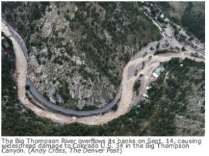
The Big Thompson and Poudre rivers have likely already reached their peaks, Hodges said. The Big Thompson reached about 5.8 feet — action stage for flooding is 6.5 — above the canyon mouth on Thursday, according to the Colorado Division of Water Resources…
The Poudre reached about 5.7 feet at the canyon mouth Friday. Action stage is 6.5 feet. It peaked at about 5.5 feet through town on Friday, well below the action stage of 9 feet.
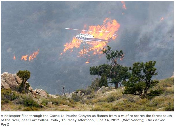
The warmer temperatures in Colorado’s mountains are expected to melt quite a bit of snowpack. Be warned that Colorado’s rivers and waterways will be swollen with fast moving and powerful water, making them very dangerous. Three people have died in three separate incidents over the past week in Colorado rivers.
Nearly six years after the Big Thompson River flood wrecked U.S. Highway 34, stranded Estes Park and wiped out bridges and homes, the U.S. government has yet to fund $20 million of repairs in Larimer County.
The county hasn’t started construction on County Road 47 (Big Elk Meadows) and County Road 44H (Buckhorn) because of the lack of funding. The county finished work on Big Thompson River bridges destroyed and rebuilt after the flood but hasn’t been reimbursed by the Federal Emergency Management Agency for the project.
The delay in FEMA funding for Larimer County’s last three flood recovery projects has county officials in a bind: As another construction season looms without federal money, so does a crucial state deadline.
Colorado’s general fund has paid for about 13% of Larimer County’s flood restoration work since 2013. Come September 2020, state funding for the projects will dry up.
“We will not be able to meet that deadline with the delays we’ve had because of this issue,” said Lori Hodges, Larimer County emergency management director. “Our biggest projects are at risk because we haven’t gotten the guidance we need.”
The holdup is essentially a bureaucratic issue. Congress passed a law in October 2018 changing the way FEMA awards money for disaster recovery work.
FEMA used to deny funding for all projects that didn’t meet a strict set of code compliance guidelines. The guidelines had little wiggle room for projects on roads and bridges in complex terrain — like the ones destroyed by the flood in the Big Thompson canyon. For example, a road repair in a narrow, rocky canyon probably couldn’t meet FEMA’s requirement for shoulder width.
The Disaster Recovery Reform Act of 2018 instructed FEMA to award money for projects that don’t meet the strict guidelines as long as a local engineer signs off on the work and agrees a waiver is necessary. Congress gave FEMA 60 days to give its regional offices guidance on how to award funding under the new law.
But FEMA hasn’t done that yet, so regional officials won’t fund the implicated Larimer County projects, Hodges said. FEMA Region 8 spokesperson Lynn Kimbrough told the Coloradoan the office paused a Larimer County funding appeal as it waits for policy guidance from headquarters…
CR 47, partially destroyed by the flood, branches off U.S. Highway 36 between Lyons and Estes Park. The road is accessible but unpaved. An 11-mile stretch of CR 44H, located in Buckhorn Canyon and the Roosevelt National Forest, was heavily damaged in the flood and the High Park Fire in 2012.
Lake Granby spill June 2011 via USBR. Granby Dam was retrofitted with a hydroelectric component and began producing electricity earlier this year as water is released in the Colorado River.
Unit owners of the Colorado-Big Thompson project, which delivers Colorado River water from the wet Western Slope to the dryer Front Range, will get 70% of their quota this year, according to a Northern Water news release.
The 70% allocation means that a farmer who owns 10 acre-feet of Colorado-Big Thompson water will get seven in a year, with the remaining three kept in storage for use in dry years…
In wet years like this one, Northern sometimes downsizes the quota of Colorado-Big Thompson water distributed, since native streams can be full enough to provide farmers late-season growing supply, which provides Northern a storage opportunity for use in dry years.
But the move to boost the Colorado-Big Thompson quota from 50% — the level normally set at the start of Northern’s water year in November just to get users through the winter so snowfall can inform spring allocation rates — ensures farmers will have a more flexible late growing season.
The quota increases available Colorado-Big Thompson water supplies by 62,000 acre-feet from the initial 50% quota made available in November…
The snow-water equivalent mark for the Upper Colorado Basin is 120% of the normal median as of Thursday, according to the U.S. Bureau of Reclamation, with snowpack levels in other river basins across the southwest at even higher marks. But KUNC and The Aspen Times reported this year that despite the good snowfall this winter, officials predict spring runoff won’t be enough to replenish reservoirs across the southwest, because years of drought have left dry soil that sucks up extra drops.
“Modeled soil moisture conditions as of November 15th were below average over most of the Upper Colorado River Basin and Great Basin,” the Colorado Basin River Forecast Center stated in its April 1 report. “In the Upper Colorado River Mainstem River Basin, soil moisture conditions were below average in headwater basins along the Continental Divide, and closer to average downstream.”
Water from the Colorado-Big Thompson project supplements other sources for 33 cities and towns, 120 agricultural irrigation companies, various industries and other water users within Northern Water’s 1.6 million-acre service area, across parts of eight counties, the Northern release said.
Westwide SNOTEL basin-filled map April 11, 2019 via the NRCS.
The reconstruction of U.S. 34 in the Big Thompson Canyon was chosen from 820 construction projects nationwide to be named Best of the Best by Engineering New Record.
Several partners in the project — Kiewit Construction, Colorado Department of Transportation, Jacobs, the engineering firm, and a handful of subcontractors — are named on the award that was presented Friday in New York City.
“You would not believe the projects it beat out — vertical construction, a new cadet building for the Army, other just very complicated projects,” said Doug Stremel, project manager with Jacobs.
“It’s really exciting … It was a collaborative effort for CDOT, Kiewit and Jacobs and the others. It was a team effort. We’re happy to share in it, but it really was a collaborative effort.”
Through an Intergovernmental Agreement, the Upper Thompson Sanitation District (UTSD) and the Town of Estes Park (TEP) are partnering to complete a utility infrastructure project that will impact the Fish Creek Lift Station and Mall Road.
The work, which is expected to start on Jan. 28, will start with replacing a single, 45-year-old sanitary sewer force main with new, dual-force mains. These will extend from the Fish Creek Lift Station, located on Fish Creek Road next to Lake Estes, across U.S. 36 to UTSD’s gravity sewer main near Joel Estes Drive.
“UTSD recognized the lift station force main was a critical piece of infrastructure, had been in operation for 40 years, and due to its design features, had received minimal maintenance,” said UTSD District Manager Chris Bieker.
Bieker explained that force mains are pressurized sewer pipes that convey wastewater where gravity is not possible.
“Moving the flow uphill requires a pump,” he said. “Pumping facilities called lift stations may be required to transport the wastewater through the collection system.”
According to Bieker, “The Fish Creek Lift Station and approximately 1,000 linear feet of 14-inch diameter cast iron force main was constructed in the mid-1970s. The interior of the force main is cement mortar lined. Approximately 600 linear feet of force main is located south of Highway 36. The remaining 400 feet crosses north underneath HWY 36 and discharges to a manhole located in Mall Road. Wastewater then flows along Mall Road through approximately 1200 linear feet of gravity sewer main to the treatment facility…
In late 2016, the District televised the interior of the force main. The video indicated cracking and delamination of the cement mortar pipe lining within sections of the force main. The televising operation prematurely ceased when the camera could not proceed any further due to the internal conditions of the pipe.”
New piping and valves will be added to the Fish Creek Lift Station. Old, aging pipes and valves will be replaced to facilitate new parallel force mains. As the Fish Creek Lift Station manages over a third of all of the district’s water flows, these improvements are critical to UTSD operations and public health.
Here’s the release from Reclamation (James Bishop):
The Bureau of Reclamation is forecasting a notable increase in releases from Olympus Dam to the Big Thompson River beginning on September 20, 2018.
As of today, September 18, releases from Olympus Dam into the Big Thompson River are at 26 cubic feet per second (cfs). Between September 20th and October 12, releases are expected to rise to approximately 225 cfs.
This forecast assumes native inflows into Lake Estes as well as irrigation demands will not change significantly from our current projections, but both are subject to unexpected fluctuations.
Looking west into the narrows after the Big Thompson Flood July 31, 1976
Big Thompson River near RMNP
Big Thompson Flood, Colorado. Cabin lodged on a private bridge just below Drake, looking upstream. Photo by W. R. Hansen, August 13, 1976. Photo via the USGS.
Here’s the Coyote Gulch 40th anniversary post from 2016. There’s a great passage from Allen Best who was part of the rescue effort back then. Click through for all the links to the Coloradoan and other online content.
If you live in Denver subscribe to The Denver Post. Their link for Allen’s article is still up. And since I”m pitching journalism here subscribe to Allen’s Newsletter.
The county commissioners on Tuesday approved a contract to work with the nonprofit river coalition on continued revegetation in key areas of the flood-damaged canyon with a $175,342 grant from the Colorado Water Conservation Board. To match the grant, the county and watershed coalition will put in $175,386, part in cash and part in staff and volunteer resources.
Commissioners Donnelly and Steve Johnson voted 2-0 at their weekly administrative matters meeting to approve the contract, allowing county resources to be used for the project. Lew Gaiter, the third commissioner, was absent.
The county’s in-kind contribution will be worth $23,490, including work by weed specialist Casey Cisneros, and its cash share will be $94,797 from the Larimer County Disaster Fund. The watershed coalition will pitch in $7,250 in cash and $49,849 of in-kind help, including volunteer labor.
This project will focus on the Big Thompson River near Drake, Cedar Cove and Jasper Lake as well as the North Fork of the Big Thompson from Drake all the way to Glen Haven.
Restoration projects have focused heavily on both private and public land along these areas, but additional work is needed for continued weed management and erosion control, said Shayna Jones, coalition director.
“These are areas that received a lot of time and effort in the past,” said Jones. “This is about making sure those improvements are maintained and stay on the right trajectory. … We’ll be able to identify the key focal areas that need a little more attention.”
This work, Donnelly said, is important to the fishery of the river, which is an economic driver for the region, to recreation along the river and to the quality of water that the river delivers to residents, including those who live in Loveland. These projects, he said, help restore the ecosystem and all river functions.
As of March 14, the state sits at about 67 percent of the average snowpack, according to the Natural Resources Conservation Service.
Things are looking slightly better in northern Colorado, with the two basins that impact Weld County — the Upper Colorado and the South Platte — at 77 percent and 81 percent of the average year, respectively…
Eric Brown, spokesperson for the Northern Colorado Water Conservancy District, said the dry weather is on Northern Water’s radar, just like it’s on farmers’, but there may be one saving grace — a healthy amount of water in reservoir storage.
Northern Water’s reservoirs are at one of their highest ever levels, with storage at 121 percent of average. Across Colorado, reservoir storage is at about 117 percent of the historic average. While Brown said the water district is optimistic that, in true Colorado fashion, there’s a big spring storm a’comin’, its prepared to use some of its reserves to combat an abnormally dry year.
“In general, farmers who have access to some sort of water in storage should be okay for 2018, as Northern Water’s C-BT Project and reservoirs across the South Platte Basin are sitting at solid levels for the most part,” Brown said. “But for the farmers who don’t have access to water that’s in storage, they really need snow and/or spring rains in the near future.”
But for everyone, use of the water in storage this year creates uncertainties down the road, as some of the current surplus will be used up. Plus, a good, wet snow would bring some much-needed moisture to the plains and help with soil quality, which plays an important role in crop health.
The Northern Water Board will set its quota for C-BT deliveries for the remainder of the 2018 water delivery season at its April 12 board meeting. Both snowpack and C-BT and local non-C-BT reservoir levels will factor into this decision. The board sets a quota each year to balance how much water can be used and how much water needs to stay in storage, and the historic average for the quota is 70 percent.
Colorado-Big Thompson Project Map via Northern Water
The drought of the 1930s was the impetus for the Colorado-Big Thompson Project.
Work started in 1938 and would span nearly two decades to complete.
The first project was the Green Mountain Reservoir on the Blue River. The water stored ran north into the Colorado River and is used to compensate for water that would be diverted to the Eastern Slope.
A significant year for the project was 1944 when work ended on the Alva B. Adams Tunnel, just over 13 miles long. It carried water under the Continental Divide.
Lake Granby, the largest reservoir in the system, stores Colorado River water during the spring runoff. A second project was the nearby Shadow Mountain Reservoir connected to Grand Lake by a short canal. The two bodies of water are nearly 90 feet higher than Lake Granby.
The Alva B. Adams Tunnel’s west portal is on the east side of Grand Lake which, incidentally, is the largest natural water body in Colorado.
After the spring runoff and to keep Shadow Mountain Reservoir and Grand Lake filled, a pumping station brings Lake Granby water up to their level.
Added in 1951-52 and on the west side of the Continental Divide is the Willow Creek Reservoir. A pumping station elevates the water 175 feet to a canal flowing into Lake Granby.
The 9 ½ -foot in diameter Alva B. Adams Tunnel drops 109 feet in its 13 miles, ending at the East Portal.
From a small lake at the East Portal, the water is carried via a siphon under Aspen Brook to the Rams Horn Tunnel and via a penstock, down to the Marys Lake power plant. This is a drop of 205 feet.
Running directly under the summit of Prospect Mountain, yet another tunnel and penstock delivers water to the Lake Estes power plant, a drop of 482 feet.
From Lake Estes, water flows east first through the Olympus Tunnel to the 5 ½ -mile long Pole Hill Tunnel.
Water is delivered to the top of a canal then to a penstock. It drops 815 feet to the Pole Hill power plant. From there, the water enters the 1 ¾ -mile-long Rattlesnake Tunnel, ending on the west side of Pinewood Lake. An intake on the east end of Pinewood Reservoir takes water through the Bald Mountain Tunnel to the penstock visible from Loveland.
Water is delivered to the Flatiron power plant at Flatiron Reservoir over 1,000 feet below.
This is where things get complicated.
During times of excess water, it is pumped up to Carter Lake, 277 feet higher.
Water also flows through a short tunnel north to the Hansen Feeder Canal to Horsetooth Reservoir.
From the south end of Carter Lake, water is delivered into the South St. Vrain Supply Canal. This long canal takes water under part of Rabbit Mountain all the way the Boulder Reservoir.
In all, West Slope water drops nearly 3,000 feet during its journey to the East Slope.
The Colorado-Big Thompson Project has created a dozen reservoirs, uses 35 miles of tunnels and also generates a substantial amount of electric power. These are the power plants:
Aerial view of Lake Estes and Olympus Dam looking west. Photo credit Northern Water.
Here’s the release from Reclamation (James Bishop):
The Bureau of Reclamation, in cooperation with Estes Valley Recreation and Park District (EVRPD), is seeking public input on a Resource Management Plan (RMP) for Lake Estes, Marys Lake and East Portal lands.
The agencies will host an open house where the public can learn and ask questions about the resource management planning process, the lands affected by the plan, and provide comments. The open house will be held on Wednesday, October 25, 2017, from 6 to 8 p.m. at Estes Park High School Commons, 1600 Manford Avenue, Estes Park, Colo. Public comments will be welcomed in writing at the open house and throughout the 30-day public comment period.
The 30-day public comment period will begin on Wednesday, October 18, 2017 and will end at close-of-business on Friday, November 17, 2017. Comments must be provided in writing and can be submitted by e-mail, fax, or regular mail. E-mail comments can be sent to EstesRMP@usbr.gov, and faxed comments can be sent to the attention of Ms. Justina Thorsen at (970) 663-3212. Regular mail comments should be sent to the attention of Ms. Thorsen at: Bureau of Reclamation, 11056 W. County Road 18E, Loveland, Colo. 80537.
Reclamation is preparing the Estes Valley RMP. The agency will also prepare an Environmental Assessment in compliance with the National Environmental Policy Act. Reclamation owns and operates the Colorado-Big Thompson project, which includes Lake Estes, Marys Lake, East Portal, and the surrounding federal lands. Through a management agreement with Reclamation, EVRPD is responsible for managing recreation at Lake Estes, Marys Lake, and East Portal. The RMP will guide future recreation development as well as the management of natural and cultural resources on federal lands.
Media inquiries or general questions about Reclamation should be directed to James Bishop at 970-962-4326 or jbishop@usbr.gov. Specific questions about the resource management planning process should be directed to Justina Thorsen at 970-962-4207 or EstesRMP@usbr.gov.
This stretch of the Big Thompson River, from the Jasper Lake bridge to just before the Cherry Cider Store, was scoured and severely changed during the 2013 floods. It was left too wide and entrenched, with vegetation ripped away from the banks.
The new face of the river has a narrower channel with more areas along the banks for waters to disperse in the event of another flood.
It has large boulders specifically placed to control the flow of the water and to create pools for fish habitat.
There are large trees that extend from under the banks into the river, stabilizing the bank, preventing erosion and creating habitat.
And trees, forbes and shrubs were strategically planted, again to stabilize the banks, prevent erosion and create shade and habitat.
“We’ve really made it look like a river again,” said Shayna Jones, watershed coordinator with the Big Thompson Watershed Coalition.
The goal was to mix several different restoration techniques — the planting, the rocks, the tree trunks — to improve the river while keeping it natural, which from the look of the river is mission accomplished.
“It’s a really good mix of types of restoration,” added Jones.
Even the planting is mixed for diversity and meticulously planned out. The project team chose all native vegetation and placed different shrubs, trees, forbes and grasses in different zones along the banks. The willows, live stands transplanted from the river corridor nearby, are close to and in some spots in the water, while pine trees are further away up the shore.
The trees and shrubs are planted in clumps to mirror nature, not in neat rows as a gardener would do.
Much of the vegetation was transplanted from the natural surroundings, while other plants were specifically grown by the Colorado State Forest Service for river restoration.
This project is among five already completed by the Big Thompson Watershed Coalition and its partners, which have more planned this year in the Big Thompson as do other entities like the city of Loveland and Colorado Department of Transportation.
The recently completed work, called the Jasper Lake project, spans a half mile of the river on both the north and south sides of the highway and crosses private, Larimer County and U.S. Forest Service land.
It cost $800,000 with the money coming from a mixture of federal, state and private sources, including the Natural Resources Conservation Service, the Department of Local Affairs, the Colorado Water Conservation Board, Rocky Mountain Flycasters and the Trout and Salmon Foundation.
Though the river project abuts Narrows Park, that piece of public land has not yet been restored. Owned by Larimer County, that park will serve as the site of a temporary bridge crossing the river while the county replaces the Jasper Lake Bridge this fall, so restoration is planned by the county after that bridge project, according to officials involved with the restoration project.
The Big Thompson Watershed Coalition worked with contractors and several partners, including private landowners, on this project. Walsh said one of the greatest parts was to meet the people, to listen about the river’s past and to explain the new, healthier river that was being created.
For more than 20 years, Anderson has organized the event that commemorates the 1976 flood that started with heavy rain on July 31, 1976. It caused a massive surge of water to race down the Big Thompson Canyon with little warning, resulting in the deaths of 144 people.
Community members have gathered yearly at the memorial outside the volunteer firehouse to remember those victims. Five candles are lit for those who were never found: Rochelle Rogers, Teresa Graham, George McCarty, Vernon Oler and Evelyn Kindred.
Monday night, Pastor Paul Logue from Estes Park Baptist church officiated while Jerry Shaffer provided music and Daryle Klassen offered a tribute.
Bob Graham shared his memories of losing his wife Beverly and two young daughters. Teresa and Lisa. He also lost his mother, Clara Graham.
Graham recounted his experience both during and after the flood.
“It would have been unbearable if not for good friends at the Loveland Fire Department,” he said.
“The loss of one’s children is the greatest loss a parent can endure,” he added.
Linda Marriner of LaPorte comes each year to remember her father, Doc Ealy Lee, who died in the flood.
“He loved that river,” she said. Her father loved to fish and went every chance he got, although he would never keep his catch. Linda said he hated the taste.
Linda was joined by her son Luke, his wife Amy and their two sons, Colby, 3, and Caden, 5.
“It’s really about being with my mom,” Luke Marriner said. He has been to the ceremony every year.
He said his mom always talked about his grandfather while he was growing up.
“It was probably more me asking than her telling,” he said, and they have continued to talk about him with the two young boys as the anniversary rolls around.
“It’s important to keep this alive,” Luke said.
Each year, scholarships are given to living relatives of those who were lost. The scholarships come from donations, various fundraisers and sales of books “The Big Thompson Flood” and “Big Thompson Flood Disasters.”
The four recipients for 2017 are Drew Lanig, of Missouri, who is the great-grandson Joseph Appelbaum; Haley Haskell, of Iowa, who is the great-granddaughter of William and Emma Haskell and who lost four other family members; Shannon Peistrup, of Littleton, who is the great-granddaughter of Norma Peistrup; and Trenton Drake Allison, of Kansas, who is the great-grandson of Gene and Faith Saunders.
All told, Colorado’s deadliest natural disaster claimed 144 lives, injured scores of others, and permanently altered memories and landscapes alike. It prompted new talks about living in flood country and became the “where were you” moment for a generation, ranking alongside Dec. 7, 1941, and Sept. 11, 2001.
The annual commemoration of the 1976 Big Thompson Flood is scheduled for 7 p.m. Monday at the site of a flood memorial one mile east of Drake Road on U.S. Highway 34.
The flash flood of July 31, 1976, in the Big Thompson Canyon took 144 lives, making it the worst natural disaster in Colorado’s history.
The memorial service will include speakers, music, announcement of academic scholarships to relatives of flood victims, and light refreshments. Participants should bring a lawn chair for their comfort.
It may not look like it as the Big Thompson River and Fall River continue to race through the middle of town and a very noticeable snowpack still looms in the high country, but experts believe the peak runoff for this current season has just occurred and that we should soon see the water levels dropping.
“Right now what we can say is that it (the seasonal runoff) is comparable with previous years and we are pretty certain that it has already peaked, probably two days ago,” said James Bishop on Wednesday afternoon. Bishop is the Public Involvement Specialist for the U.S. Bureau of Reclamation in Colorado…
The flow of the Big Thompson River at Moraine Park peaked at 755 cubic feet per second (cfs) at 2:15 a.m. Sunday morning. Since then, the flow has dropped significantly to 613 cfs on Monday to 267 cfs by late Wednesday afternoon…
Checking U.S. Geological Survey Water Resources charts finds that the Big Thompson River flow just below Lake Estes peaked at 804 cfs at 3:15 a.m. Tuesday while the Big Thompson River flow at Loveland peaked at 492 cfs at 11:30 a.m. Tuesday.
It is hot and the river looks tempting, but it is still too early to safely tube the Yampa River…
Not only is the water currently very turbulent, but it is also very cold. Steamboat Flyfisher was reporting a water temperature Wednesday of 54 degrees.
Just last week, the Army Corps of Engineers approved the Chimney Hollow reservoir project, which will hold 90,000 acre feet of water and feed several Front Range communities, including Greeley.
Such infrastructure is vital for future growth, regardless, [Brian] Werner said.
The fight is not over. The conservancy district will continue to fight for the Northern Integrated Supply Project, a proposed water storage and distribution project that will supply 15 northern Front Range communities with 40,000 acre feet of water. That’s been held up at the Army Corps of Engineers for more than a decade. A decision is expected next year.
“Chimney Hollow and NISP will put a major dent into what we’ll need down the road,” Werner said. “More people are coming whether we build this or not. Our future looks a lot better having some of these storage buckets with more people than a lot more people and no storage buckets. We’ll start drying up more farms. We’ve got to have water.”
In addition to water storage, the city of Greeley, has an intense focus on proper drainage to combat the decades-old problem of flooding in Greeley.
Joel Hemesath, public works director, said the city has been working for the past two years with some bond money to improve drainage in and around Greeley. He said the city is gearing up for downtown projects, as well, that will route drainage to a detention pond by the Poudre River via bigger pipes.
Since 2012, the city has spent a little more than $17 million on stormwater projects.
The city also works hard to improve trails, dedicating just shy of $900,000 to them since 2012.
Hemesath said the city would like to extend Sheep Draw Trail through some more western subdivisions, and extend the Poudre Trail farther east.
Site of Chimney Hollow Reservoir via Northern Water.
Map from Northern Water via the Fort Collins Coloradan.
Chimney Hollow Reservoir site via the Bureau of Reclamation
Site of proposed Chimney Hollow Reservoir — Windy Gap Firming Project via the Longmont Times-Call
Windy Gap participants (2012)
Windy Gap Reservoir
Windy Gap Reservoir
Here’s the release from the US Army Corps of Engineers Omaha District (Kiel Downing/Cheryl Moore):
The Corps of Engineers, Omaha District, finalized its Record of Decision (ROD) approving the Windy Gap Firming Project on May 17, 2017. The project is proposed by the Municipal Subdistrict, Northern Colorado Water Conservancy District (Subdistrict) and involves the construction of Windy Gap Firming Project Water Supply facilities for its customers and 13 other Front Range water providers. The Subdistrict requested a Section 404 Clean Water Act (CWA) Permit from the Corps’ Omaha District Denver Regulatory Branch. “Due to the potential for significant environmental impacts to the East and West Slopes of Colorado, this project resulted in the preparation of an Environmental Impact Statement (EIS)” said Kiel Downing, Denver Regulatory Office Chief. The U.S. Bureau of Reclamation (Reclamation) was the lead federal agency preparing the EIS, and the Corps participated as a Cooperating Agency.
The original Windy Gap Project, constructed in the early 1980’s, was intended to provide more than 40,000 acre-feet of firm yield to the east slope, but due to operational constraints that didn’t happen. The project currently captures water from the Colorado River, pumps it to existing reservoirs on the west slope and moves the water through a tunnel system (the Colorado-Big Thompson Project operated by Reclamation) to the Front Range of Colorado. Because of the historic deficiency in water deliveries and lack of storage, the Windy Gap Project participants have not been able to fully rely on existing Windy Gap Project water for meeting a portion of their annual water demand. As a result, the participants, initiated the proposed construction of the Chimney Hollow Reservoir, which would firm all or a portion of their individual Windy Gap Project water allotment units to meet a portion of existing and future municipal and industrial water requirements. The Chimney Hollow Reservoir, as proposed, is a 90,000 AF capacity reservoir that will be dammed at the northern and southern limits.
Reclamation published the Windy Gap Firming Project, Environmental Impact Statement in November of 2011, and ROD on December 12, 2014. The State CWA Section 401 Water Quality Certification began shortly thereafter with the Subdistrict submitting its application to the State in March of 2015. The State issued the Section 401 WQC for the WGFP on March 25, 2016. This determination was necessary for the Corps determination under Section 404 of the CWA. The Subdistrict provided the Corps its Mitigation Plan for permanent and temporary impacts to Waters of the U.S. associated with the WGFP on March 17, 2017 and the Corps with continued agency collaboration, updated study information, and new Federal and State requirements, finalized their ROD shortly thereafter marking the end of the federal approval process.
Kiel Downing, Denver regulatory office chief for the Corps of Engineers, announced Wednesday afternoon the Record of Decision for the Clean Water Act permit for the Windy Gap Firming Project, which includes the reservoir.
With the final federal permit in hand, Northern Water officials can start planning for construction of the $400 million project, which is set to start in late 2018 or early 2019, according to Northern Water Public Information Officer Brian Werner.
“We’re smiling,” Werner said. “These things come along once in a generation.”
Berthoud-based Northern Water will manage the construction of a pair of dams in a valley west of Carter Lake that will hold approximately 90,000 acre-feet of water, or about 29 billion gallons — enough water for more than 90,000 households.
Water to fill Chimney Hollow will come from the Colorado River basin in years when its flows are above average. The water will be carried through a diversion at Windy Gap Reservoir in Grand County to Lake Granby and the Colorado-Big Thompson Project.
Municipalities including Loveland, Fort Collins and Greeley conceived of Windy Gap in 1970. The need for storage space for the communities involved to “firm” their ownership of the Windy Gap water rights expanded in later years to include Chimney Hollow Reservoir because in above-average precipitation years, Lake Granby often does not have enough space to store the additional water.
Rep. Hugh McKean, R-Loveland, said he was ecstatic when he heard about the Corps of Engineers’ approval, comparing it to Christmas.
In his time serving on the Loveland City Council and then the Colorado House of Representatives, he has seen how much the storage project was needed…
For cities such as Loveland, Windy Gap water fills an important role for its municipal users because it is a 365-day-a-year, deliverable water source, unlike in-basin seasonal water offered through local ditch companies. It will join the Colorado-Big Thompson Project shares in the city’s water portfolio…
McKean acknowledges that because the water has not been diverted before, questions and concerns will emerge from Western Slope water users and communities. However, because the Windy Gap Firming Project water is available only in years of above-average flows on the Colorado River, municipalities on the Front Range won’t be served until water rights holders on the Western Slope get their allocations.
He said he will be in Montrose this summer at a meeting of the Uncompahgre Water Users Association to talk about the project’s effect on the basins and in the context of the state water plan.
From the Associated Press (Dan Elliott) via The Colorado Springs Gazette:
The federal government gave final approval Wednesday for a $400 million dam and reservoir in northern Colorado where 13 cities and water districts will store water from the other side of the Continental Divide.
The Army Corps of Engineers issued a permit for construction of the Chimney Hollow Reservoir in the foothills about 50 miles (80 kilometers) north of Denver.
The corps regulates some of the environmental impacts of big water projects.
It is the last approval the reservoir needs, said Brian Werner, a spokesman for the Northern Colorado Water Conservancy District, which oversees the project.
Construction could start in early 2019, after the district refines the plans, hires a project manager and awards contracts.
Water for the reservoir would be pumped from the Windy Gap Reservoir on the Colorado River near the town of Granby, west of the Continental Divide, through an existing tunnel under the Rocky Mountains to the east side of the divide.
The 13 water providers own the rights to the water but have nowhere to store it. The project is formally called the Windy Gap Firming Project because it would firm up the water supply.
The Chimney Hollow Reservoir will store up to 90,000 acre-feet (1.1 million cubic meters). One acre-foot (1,200 cubic meters) can supply two typical households for a year.
New reservoirs are always contentious in Colorado. Water managers and urban planners argue the state needs more because it does not have the capacity to store all the water it is entitled to under agreements with other states. They also say Colorado needs more water for its growing population.
Some conservationists oppose new reservoirs because of their environmental damage and because the state’s rivers are already overtaxed.
“The Colorado River is on life support right now,” said Gary Wockner, director of Save the Colorado. “If the patient is bleeding out, you don’t cut open a new artery to try and heal it. Instead, you should work to protect and restore the river, not further drain it.”
Wockner said his group will likely challenge the Corps of Engineers permit in court.
Trout Unlimited negotiated some environmental improvements in the Colorado River near the Windy Gap Reservoir as part of the project. Mely Whiting, an attorney for the group, said she had not yet seen the final Corps of Engineers permit.
Water providers that will pay for and benefit from the Chimney Hollow Reservoir are the cities of Broomfield, Erie, Greeley, Longmont, Louisville, Loveland, Superior, Evans, Lafayette and Fort Lupton, as well as the Central Weld County and Little Thompson water districts.
The U.S. Bureau of Reclamation has announced that it has begun to increase the amount of water it is releasing from Lake Estes into the Big Thompson River by way of Olympus Dam.
The increase began Monday, according to the bureau on its Facebook page.
The increase will go from the current level of 50 cubic feet per second (cfs) to about 100 cfs. The exact cfs released will depend on inflows into Lake Estes, but the range will be between 50 cfs and 100 cfs, the announcement said.
A cubic foot of water is equivalent to 7.48 gallons. That means there are 748 gallons in 100 cubic feet of water. The average American home uses 400 gallons of water a day, or about half of the flow when it’s 100 cubic feet.
The release from the lake into the river is expected to increase through the spring as the annual runoff flows increase.
The U.S. Bureau of Reclamation owns and operates Lake Estes and Olympus Dam as part of the federal trans-basin diversion Colorado-Big Thompson water project.
Water level and runoff information regarding Olympus Dam and Lake Estes can be found on the Bureau’s Facebook page at http://facebook.com/LakeEstesandOlyDam.
Every fall, biologists count the fish to get an overall view of the river’s health. A healthy river means a lot of healthy fish, trout in this case, rainbow and brown. And a healthy fish population means a healthy local economy with jobs dependent on the fishing and recreation industry.
“People come to Estes Park for a lot of reasons, and fishing is one of them,” says Jack Deloose, who has been a fishing guide in Estes Park for four years. “We get an awful lot of people. We’ll probably end up with 600 people that will fish with us this year.”
An estimated 50,000 anglers descend on this area annually, spending on average $103 each on everything from fishing guides and equipment to lodging and food…
About $4 million a year flows into local coffers as a result of this river. As so much tourism depends on the fish, the results of the annual fish count are closely watched.
The biologists conduct the count at two separate sites. This area is in good shape. There are shallow spots where the fish like to spawn, and rock pools for winter habitat. Further downstream, it’s a different story.
Immediately after the 2013 flood, the fish population there was zero. It slowly recovered, but a concrete spill into the water earlier this year during road repairs set the recovery back.
Permanent repairs have begun on the parts of the river and adjoining highway that were most damaged by the floods, but Swigle says the repairs will also tackle problems dating back 40 years.
“We’ve been educated from two floods, 1976 and 2013. In both cases, the flood won and the river lost,” says Swigle. “Now we’re building a road that is resilient in the face of flooding, so when it happens again—and it will—we won’t have to spend $500 million to repair the road.”
The repairs will raise the adjoining road and create a wider floodplain. That will help the river cope with future floods.
After collecting the fish, the task of counting, weighing and measuring them begins. The number of fish in this stretch amounts to almost 4,000 total per mile, indicating a healthy section of the river. Further downstream, as predicted, the fish count is much lower, in the low hundreds of fish per mile. But Swigle is hopeful that those numbers will improve in the future.
“Ultimately we’d like to see the number of trout that we found here, downstream in the same abundance,” Swigle says.
Repairs on that lower stretch started in October and will likely continue through June 2017.
Scott Hummer, general manager of North Poudre Irrigation Company, talks about how his agency worked with Fort Collins Natural Areas and Colorado Parks and Wildlife to include a fish passage when the irrigation company replaced a diversion structure on the Poudre River that was destroyed by the 2013 floods. Work was completed [in February 2016]. (Pamela Johnson / Loveland Reporter-Herald)
Here’s the release from Colorado State University (Jim Beers):
The Cache la Poudre River, which flows from the mountains through Fort Collins, Timnath and Windsor to the plains east of Greeley, is at the heart of countless activities: from irrigating crops and lawns to providing drinking water for more than 365,000 people and hosting numerous recreational activities.
Those with connections to and concerns for the Poudre River will gather on Friday, Feb. 3 for the fourth annual Poudre River Forum. After its first three years at Larimer County Fairgrounds, the forum is moving down the river to Greeley as a reminder that the Poudre River is important to all who benefit from it — from its headwaters to its confluence with the South Platte. This year’s forum — the theme is “As the Poudre Flows — Forest to Plains” — will be held from 8:30 a.m.-4:30 p.m. at the Island Grove Events Center, 501 N. 14th Ave., Greeley. Pre-registration is required for all participants.
Understanding the river, each other
Sponsored by the Poudre Runs Through It Study/Action Work Group, the forum serves as a community-wide gathering of people from agricultural, municipal, business, recreational and environmental backgrounds to learn about and discuss issues related to the Poudre River.
“The Poudre River Forum brings together those who use the river for agricultural and urban diversions and those who work to improve its ecological health. In the past those groups have not necessarily seen eye to eye,” said MaryLou Smith, PRTI facilitator. “Increasingly our participants are open to the idea that it takes collective vision and action to make the Poudre the world’s best example of a healthy, working river.”
Once again, this year’s event will be facilitated by the Colorado Water Institute at Colorado State University. “The Forum is a great opportunity for the communities connected by the Poudre River to come together to better understand the entire watershed, and each other,” said Reagan Waskom, director of CWI.
Forests and water quality/quantity
Laurie Huckaby with the U.S. Forest Service, will present “The last 1,000 years in the Poudre according to the trees,” to kick off the topic of how important the upper watershed is to water quantity and quality.
“Water quality and forests are inextricably linked,” said Joe Duda of the Colorado State Forest Service, who will join Huckaby as one of the presenters. “Forest conditions and insects, disease and fire all can have profound impacts on water flow and quality. Only healthy, resilient forests can continuously supply clean water.”
Global lessons for local success
“Finding the Balance: Managing Water for People and Nature” is the message of keynote speaker Brian Richter. Richter has been a global leader in water science and conservation for more than 25 years, and currently serves as chief scientist for the Global Water Program of The Nature Conservancy in Washington D.C. Richter’s ideas about the importance of recognizing the balance of working river/healthy river are the basis for which PRTI was initially formed. He has consulted on more than 120 water projects worldwide, and has served as a water advisor to some of the world’s largest corporations, investment banks, the United Nations, and has testified before Congress on multiple occasions. Richter co-authored,with Sandra Postel, the 2003 book Rivers for Life: Managing Water for People and Nature and in 2014 wrote Chasing Water: A Guide for Moving from Scarcity to Sustainability.
Change affects all sectors
An afternoon panel session will probe the impacts of change — positive and negative — along the Poudre River and how they have been similarly and differently addressed by agriculture, urban, and environmental sectors. They will discuss what anticipated future changes might these three sectors see as opportunities or incentives for mutually beneficial collaboration that could result in a healthier, working river?
“It has been said that the only thing that is constant is change,” said John Bartholow, retired ecologist from U.S. Geological Survey, and panel coordinator/moderator. “The question is, can we learn to adapt to those changes sure to come on the Poudre in ways that benefit agriculture, municipalities, and the environment?”
The panel will include Eric Reckentine, deputy director, City of Greeley Water and Sewer; John Sanderson, director of science, Nature Conservancy of Colorado; and Dale Trowbridge, general manager, New Cache la Poudre Irrigating Company.
Videos, displays and music too
The day-long forum also includes “River Snapshots” highlighting more than 15 projects undertaken by a variety of groups on the Poudre last year; “My How the Poudre Has Changed,” featuring historical 1970’s footage of the Poudre; updates from both the cities of Greeley and Fort Collins on current water programs; and over two dozen river-focused displays from community organizations and agencies. The day concludes with a social hour including food, beer and other beverages, and river-themed door prizes.
Registration is $50 and includes lunch. Scholarships for students and reduced rates are available. The deadline to register is Friday, Jan. 27 at http://prti.colostate.edu/forum_2017.shtml.
For more information, contact event coordinator Gailmarie Kimmel at PoudreRiverForum@gmail.com or 970-692-1443.
This year, actual work will begin to repair habitat along and inside several stretches of the Big Thompson River through a grassroots group, The Big Thompson Watershed Coalition, that formed after the 2013 flood.
“2017 is going to be a big year for projects happening on the ground,” said Shayna Jones, watershed coordinator with the coalition. “We’re talking millions of dollars in river restoration.”
A couple of projects through the coalition have already begun, but several others are going to kick off in 2017. Early in the year, the coalition will put out bids for a contractor to work on a stretch about a mile long from Jasper Lake through Narrows Park, which is in the lower section of the canyon.
Estimated to cost $900,000, the project will include stabilizing sections of the banks, planting vegetation and creating what are called flood plain benches to allow the water space to spread out in the event of a future flood, explained Jones and Tracy Wendt, assistant watershed coordinator.
The work also includes improving fish habitat in several ways, such as building pools within the river and planting vegetation in strategic places to provide shade and cover.
“There will be habitat improvements for all different life stages of trout,” Wendt said. “It’s all the phases of their life to help them.”
Because of the fish habitat component, the coalition, in partnership with Rocky Mountain Flycasters, recently received a $4,500 grant from the Trout and Salmon Foundation. And the Flycasters, a local chapter of Trout Unlimited, also contributed $2,000 to the project.
The bulk of the funding, about $500,000, will come from the Natural Resources Conservation Service with the rest of the money from the Colorado Water Conservation Board, Jones explained.
This piece of the river winds through both private and public properties and ends just before the Narrows near the Colorado Cherry Company.
Other projects also are planned further west along the river with more money coming from the NRCS and the Colorado Water Conservation Board. The exact amounts of money and grants are still being finalized, though Jones did confirm the total work would be in the millions.
Other projects to rehabilitate the river and river corridor are occurring simultaneously including one that will begin in 2017 as a partnership with the coalition and Sylvan Dale Guest Ranch.
Work began in October and will continue this spring on West Creek, and other improvements began two weeks ago on Fox Creek. Both, located along the North Fork near Glen Haven, are being built in partnership with Larimer County, NRCS and the Colorado Water Conservation Board.
Also, Larimer County, private property owners, Colorado Parks and Wildlife and Colorado Department of Transportation officials are working on separate stretches of the river, with everyone working together for overall river benefit.
“We’re making sure our projects are complementing each other to make for an overall healthy watershed,” Jones said.
She expects the work to continue over the next three years as the Colorado Department of Transportation completes the permanent repairs of U.S. 34, which also include massive river restoration work.
First water through the Adams Tunnel. Photo credit Northern Water.
From email from Reclamation (Peter Soeth):
On Monday at 5:30 pm of this week diversions through the Adams Tunnel to the east slope of the Colorado-Big Thompson Project began. While this picks up, Lake Estes will rise slightly and is expected to be return to typical levels by next mid-week.
The Olympus Dam slide gate remains set to release low-level winter flows to the Big Thompson River.
This rate of fill will be maintained for several days to ensure safe operations below the Estes Power Plant. The majority of the water in Lake Estes enters through the power plant via the C-BT Project.
First water through the Adams Tunnel. Photo credit Northern Water.
Click here to read the newsletter. Here’s an excerpt:
The C-BT Project water year ended on Oct. 31. C-BT Project storage levels on Nov. 1 were above average for a third consecutive year, with 548,274 acre-feet in active storage. The Nov. 1 average is 444,177 AF. Deliveries increased in 2016 over 2015 levels, with 204,078 AF delivered (including quota, Carryover Program and Regional Pool Program water). Forty-six percent of the deliveries were from Horsetooth Reservoir, 40 percent from Carter Lake and the remaining 14 percent went to the Big Thompson River, Hansen Feeder Canal and the South Platte River. Estimated deliveries to municipal and industrial users totaled 102,157 AF, while agricultural deliveries were approximately 101,921 AF.
Starting Oct. 27, officials from the Bureau of Reclamation turned off the water diversion tunnel from the West Slope to the Colorado-Big Thompson Project that feeds many of the lakes and reservoirs in Larimer County. The reservoir levels have also been lowered through the release of water to storage downstream.
According to a news release from the agency, the shutdown has allowed for the inspection of dams at Marys Lake and Lake Estes near Estes Park, and Flatiron Reservoir west of Loveland.
While the reservoirs are at low levels, crews are also looking at the power generation facilities at the Marys and Pole Hill power plants and the Charles Hansen Feeder Canal.
According to agency officials, the work will continue on the reservoirs and facilities throughout November, with water diversions through the Adams Tunnel from the Western Slope slated to resume in mid-December.
FromAspen Journalism (Allen Best) via The Aspen Daily News:
Nobody disputes that the Colorado-Big Thompson project has changed Grand Lake, the state’s largest, deepest natural lake. How could it not?
In the 1940s, Grand Lake was integrated into the giant C-BT, what the late historian David Lavender called a “massive violation of geography.” It’s Colorado’s largest transmountain diversion project. By one tally in the 1990s, it delivers an average 231,060 acre-feet annually from the headwaters of the Colorado River to cities and farms east of the Continental Divide. This compares to the 105,024 acre-feet from three tunnels through the Sawatch Range east of Aspen.
Almost immediately after the C-BT was completed in 1953, locals began to complain that the project shoehorned into the lake had sullied the lake’s clarity by introducing algae and sediments. This is, they insist, a violation of federal law.
The controversy pivots on Senate Document 80, a part of the Congressional authorization for project funding in 1937. The document describes the needs of irrigation, industrial and power production but also warns against impacts to nearby Rocky Mountain National Park.
The lake, if outside the park, has one of Colorado’s most memorable backdrops. The document specifies the need “to preserve the fishing and recreational facilities and the scenic attractions of Grand Lake…”
On that, say many locals, the C-BT has failed, and they say that until recently they got little response from the U.S. Bureau of Reclamation, the agency that built the C-BT.
But now, in a reversal, the bureau is working with 18 other stakeholders in an effort to solve the problem. Parties include Northern Colorado Water, the agency that manages the diversions for cities and farmers of northeastern Colorado, Grand County and other state and local organizations.
Grand Lake’s story fits into a broad theme of changed sensibilities in Colorado about 20th century river alterations. Restoration and remediation projects are starting or underway on the San Miguel River in Telluride, on the Eagle River at Camp Hale and on the Fraser River near Winter Park.
“It’s possible that at one time, the impacts of the CBT Project on Grand Lake clarity were thought to be just part of the price we pay for valuable water projects,” said Anne Castle, a fellow at the Getches-Wilkinson Center for Natural Resources, Energy and the Environment at the University of Colorado-Boulder. “Now, we are more inclined to believe that the environmental values have significance, including economic significance, and that operations can and should be adjusted to better accommodate these values.”
The work at Grand Lake also illustrates the power of persistence and spunk by advocates of environmental protection. And it involves a collaborative process called adaptive management that emphasizes consensus-based decision-making in solving stubborn issues involving water diversions.
Nobody thinks solving this problem will be easy, though. In April, after several years of working together, the Grand Lake stakeholders submitted a plan to the Colorado Water Quality Control Commission. The plan approved by the commission sets an interim clarity goal for summer pumping during the next five years.
During that time, the Bureau of Reclamation is to develop a plan for long-term solutions. Alternatives include expensive new tunnels, possibly bypassing Grand Lake altogether. A preview of the alternatives may emerge at a meeting of stakeholders in late November.
Not everybody in Grand Lake thinks that reduced clarity is a problem. “There are people who think there’s a problem, but there is no problem,” says Jim Gasner, a member of the Grand Lake Board of Trustees, the town’s elected body, and a fishing “teacher” at Rocky Mountain Outfitters.
But Elwin Crabtree, a real estate agent and former Grand County commissioner, sees something different. “It’s adverse to its natural being,” he said in early August in an interview at his office along the town’s main street of knotty-pined stores and lodges. “I think we look at it as a moral issue,” he added. “I think we believe in having responsibility to be good stewards of our environment.”
The C-BT is an effort to address what one historian in the 1950s called “nature’s error.” Even as Aspen was putting on its silver-lined britches in the 1880s, farmers along the South Platte River and its tributaries were struggling with inadequate water in late summer to finish their corn and other crops.
Grand River Ditch July 2016. Photo credit Greg Hobbs.
Irrigators set out to remedy this. The first large-scale transmountain diversion from the headwaters of the Colorado River began in 1890. Called the Grand River Ditch, it’s beveled into the side of the Never Summer Range in what is now Rocky Mountain National Park, collecting water like a rain gutter from a roof.
Then came the 1930s, the decade of the Dust Bowl, the Great Depression and the New Deal. Farmers in northeastern Colorado had long been agitating for added infusions of water from the Colorado River headwaters. But they couldn’t get it done themselves. They needed federal funding.
Map of the Colorado-Big Thompson Project via Northern Water
The flawed design
But the work along the Continental Divide from 1939 to 1953 created a wound at Grand Lake. In retrospect, the design was flawed.
The C-BT at the Colorado River headwaters consists of three main bodies of interconnected water. Only one, Grand Lake, is natural.
Farthest downstream is Granby Reservoir, which is Colorado’s third largest, capable of holding 539,758 acre-feet of water during runoff of spring and early summer. This compares to Ruedi Reservoir’s 102,373 acre-feet and Dillon’s 257,304 acre-feet.
From Granby, water is pumped upstream as needed by Eastern Slope diverters to Shadow Mountain Reservoir. Shallow, no more than nine feet deep, Shadow Mountain is directly connected through a short canal to Grand Lake.
In 2011, reservoirs east of the divide were full, so water was allowed to continue down the Colorado River without diversion. This photo shows what the lake looked like on Aug. 30, without pumping. Photo courtesy of Byron Metzler and pilot Steve Paul
The canal occupies the original path of the Colorado River emerging from Grand Lake. From the interconnected Grand Lake and Shadow Mountain Reservoir, water is then pumped through the 13.1-mile Alva Adams Tunnel underneath the national park to the Estes Park area for storage in reservoirs there and along the northern Front Range.
Shadow Mountain is a problem, though. Its shallowness allows water to be easily warmed in summer, producing algae that can float into Grand Lake. The shallowness also allows lake-bottom sediments to be disturbed more easily and dispersed into Grand Lake.
Evidence for the historic, pre-construction clarity of Grand Lake is scant: Just one measurement, taken in 1941, of 9.2 meters (30 feet).
Detailed observations during the last decade show clarity down to 6 meters (19.6 feet), but no more.
The standard adopted in April by the state agency specifies a minimum of 2.5 meters and an average of 3.8 meters (8.2 feet to 12.4 feet) during summer diversion season.
“I think the clarity standard has really elevated the discussion,” says Lane Wyatt, co-director of the water quality/quantity committee in the Northwest Council of Governments. “This is the only clarity standard in Colorado. It’s the first one we’ve ever done.”
Clarity is not the only issue, though. Water must be delivered to farms and cities. As it is flows downhill toward the Great Plains, it generates electricity distributed by the Western Area Power Authority. Purchasers of this low-cost power include Aspen Electric and Holy Cross Energy.
Canton “Scally” O’Donnell, president of the Three Lakes Watershed Association, remembers a more pristine past.
As a boy, his family summered at Grand Lake. That was in the 1930s and 1940s. “We drank the water right out of the lake, and many families did that,” O’Donnell said.
The first complaint about the sullied water was filed in 1954, the year after the project’s formal completion. In 1956, Grand Lake trustees adopted a resolution that informed Colorado’s congressional delegation of problems. The resolution was aimed at the Bureau of Reclamation.
“I think it’s fair to say that up until seven or eight years ago, the bureau pretty much stonewalled,” O’Donnell said. “They just did not want to recognize the problem, and Northern Colorado Water, the same.”
Movement has occurred during the last decade. One avenue for local protest was a proposed expansion of an existing diversion of the Colorado River at Windy Gap, about 15 miles downstream. Completed in 1985, the Windy Gap dam uses the C-BT infrastructure to deliver additional water to the Rawhide power plant north of Fort Collins, Greeley, Boulder and other cities.
The Windy Gap Firming, or expansion, plan was formally introduced after the drought of 2002. It proposes diversion of remaining water rights owned by a string of northern Front Range cities.
The effect of persistence
O’Donnell, of the Three Lakes Watershed Association, thinks the changed attitudes is explained by the persistence of individual public officials.
He singles out Lurline Underbrink Curran, then the Grand County manager. “She’s smart and she’s tough,” he said. “She just kept on beating on everybody to make it happen.”
He also points to the influence of Anne Castle, a long-time Denver water lawyer who served from 2009 to 20014 as assistant secretary for water and science in the Interior Department. Her responsibilities included oversight of the Bureau of Reclamation.
“I think part of the reason it has attention now is the fact that the Windy Gap Firming Project required the federal government to pay attention to Senate Document 80 and both C-BT and Windy Gap Firming Project do have an impact on Grand Lake’s recreation and scenic attraction. Calling attention to that issue, as both Lurline and I did, with prodding from Scally, had an impact,” Castle said.
But again, agreeing there is a problem is not the same thing as finding a solution.
“There is a lot of uncertainty about how our operations affect clarity,” said Victor Lee, an engineer for the Bureau of Reclamation.
The precise circumstances that cause algae and sediments to degrade clarity are poorly understood. Northern has been altering its diversion regimes, to see if that will improve clarity.
This year, from July until late August, pumping was conducted about 15 hours a day at 250 cubic feet per second. Clarity degraded, though. Algae growth was suspected. So the pumping was accelerated to about 20 hours a day with two pumps. Results were mixed.
It was a success, said Lee, in that they learned something. Clarity readings exceeded the minimum but did not meet the average standard. “I would say the experiment was successful, but we did not meet our objective,” he said.
Esther Vincent, water quality manager for Northern Water, said the effort to address Grand Lake’s muddled clarity is attracting attention across Colorado by water professionals. Spurring their interest, she said, is the possibility of other bodies of water being assigned clarity standards.
There’s also interest in the adaptive management process created for Grand Lake. It’s similar to but separate from Learning By Doing, which was created in response to expanded water diversions from both Windy Gap and by Denver Water’s Moffat Tunnel collection system.
Vincent also points out a deeply philosophical question. In 1937, when adopting S.D. 80, did Congress have the same notion about what constitutes “scenic attraction” as we do today?
“I am an engineer,” she said. “Asking an engineer to define what beauty is, is an interesting dilemma. It’s not a concept that lends itself very well to science.”
Editor’s note: Aspen Journalism and the Aspen Daily News are collaborating on coverage of Colorado’s rivers and water. More at http://www.aspenjournalism.org.
I hear your concerns about the water quality and taste and odor issues we are experiencing in Loveland. My goal is to be as transparent as possible by sharing information about what is causing the taste and odor issues in Loveland and what Loveland Water and Power (LWP) is doing to resolve the problem.
Loveland has been abuzz for months about the unusually large, stubborn algae bloom at Green Ridge Glade Reservoir, one source of Loveland’s drinking water. Although this bloom is fierce, the drinking water in Loveland still meets federal regulatory requirements, plus even more-stringent state standards, for drinking water.
This algae bloom in particular is the largest we have ever seen. As a result of the 2013 flood, more nutrients have entered into runoff as it makes its way to our reservoir. The extreme heat and abundant sunshine we have had this summer developed into the perfect storm for an enormous algae bloom.
This bloom has revealed new algae species that reproduce more quickly and produce stronger geosmin, the compound that causes taste and odor issues. Additionally, the Big Thompson River is now afflicted with a significant level of the same algae. We cannot treat the free-flowing river water in the same way as we do the reservoir. And at this time, we are blending water from both the river and the reservoir at the Water Treatment Plant (WTP).
LWP water quality specialists are closely monitoring water quality by testing water samples at the Water Treatment Plant as well as at homes and businesses throughout the city on a daily basis. We are also treating the reservoir with a hydrogen peroxide-based algaecide that was developed as an environmentally safe alternative to copper-based algaecides. The only end-products of the treatment we use are oxygen and water. In addition, we are using a safe, absorbent activated-carbon compound inside the treatment plant to remove as much taste, odor and color from the water as possible.
Our technical staff continues to explore safe alternatives for treating algae blooms in the future while walking a thin line between the price tag of new technology and reasonable rates for our customers. Next week, LWP will begin a feasibility study to evaluate options for algae mitigation. The study will include permanent aeration or oxygenation system in the reservoir. We will also do a preliminary design of a larger system to store and dispense the activated carbon compound at the WTP. Unfortunately, those large capital costs are currently not budgeted.
While we would like to predict when the algae will die, it is important to note that algae is a living, unpredictable organism. Blooms usually end shortly after the first frost but we have no way to predict when that might be. We will continue to update our website http://www.cityofloveland/waterquality and Facebook page http://www.facebook.com/LovelandWaterandPower with timely information as we receive it.
The safety and quality of our drinking water is one of LWP’s most important goals. We recognize the vital role water plays in our daily lives. LWP takes water quality very seriously and will continue to produce safe, clean drinking water for our customers. We ask for your patience while we work to resolve this problem and find a way to prevent it in the future.
An algae bloom in Green Ridge Glade Reservoir, the worst Loveland’s Water and Power division has experienced, is to blame for the unsavory taste and odor plaguing the city’s water supply. The blue-green algae is harmless, health-wise, according to state lab test results.
While the minuscule taste-and-odor compound released by the algae makes the taste disgusting, a lucky 25 percent of residents think the water’s fine because they can’t taste or smell the compound.
Soon, the other 75 percent of the city will have better-tasting water. The first hard freeze will mean a slow die-off of the algae bloom, water treatment manager Scott Dickmeyer said. After that, the water’s taste and smell should return to normal within a week or two.
But Loveland will have to invest in some new mitigation methods to keep the algae at bay.
Green Ridge Glade has always been susceptible to algae growth because it’s deep and relatively still. It’s not a recreation hub like Horsetooth Reservoir, from which Fort Collins gets its water, and water doesn’t flow in and out of it at a rapid rate like at Horsetooth because Loveland is its sole user.
So as temperatures rise, the reservoir’s deeper, stiller water produces nutrients that promote the growth of anabaena, a type of algae common in water systems.
Loveland officials use a hydrogen peroxide-based product to kill the algae, but the issue has gotten worse since the 2013 Big Thompson floods because of the nutrient influx and the mysterious introduction of a new species of algae that’s harder to kill.
That’s why even though the algae issue is nothing new, many residents noticed it for the first time late this summer…
The city’s been using powder-activated carbon to remove the taste-and-odor compound from the water and funneling more Big Thompson River water into its treatment plant, but each method has drawbacks.
Powder-activated carbon removes only 50 to 60 percent of the compound because it’s not great at trapping such tiny particles. Loveland’s treated water contains about 20 to 40 parts of the compound per trillion parts of water…
“It’s a very, very small amount, but most people are very, very sensitive to it,” Dickmeyer said. “It only takes about 5 parts per trillion for our customers to start noticing it.”
And within the last few weeks, algae started cropping up in the Big Thompson River, so diluting the taste with another water source wasn’t an option.
Loveland Water and Power is considering adding oxygen to the reservoir to discourage algae growth. The division is also considering more aggressive treatment options that won’t “cost a fortune,” Dickmeyer said.
Students from Estes Park High School teamed up with ecology experts from the Estes Valley Watershed Coalition on Wednesday to help rebuild the ecosystem along lower Fish Creek. That area was devastated by the flood in 2013, washing away vegetation, eroding the banks, destroying the utility infrastructure, and damaging homes.
The Coalition has been working for the last year to restore areas damaged by the flood. They selected this area of Fish Creek as their first project, according to Molly Mills, Coordinator of the Coalition. Nearly a year ago, she met with Chuck Scott, principal of the high school, and asked if the Coalition could work on restoring the river banks adjoining school property.
“I asked him for permission to work on school property,” she recalled, “and he said, ‘Only if you involve the kids and make this a learning experience,'” said Mills.
Mills agreed at once to the plan, and she took the responsibility for securing grant funding and obtaining legal permission to work on the river banks. That required several months, since there are numerous overlapping jurisdictions involved in the Fish Creek watershed.
With guidance from teacher Alex Harris, the high school’s Environmental Club began planning and recruiting their classmates for this event. Mills did some training with the students, teaching them about riverine ecology, and the proper techniques for planting trees. The students in the club then created training materials for the student volunteers.
“This has been a student-run project the whole way,” said Mills. “I brought the idea to them, and the funding; they organized the volunteers, mapped it out, and got the logistical support.”
[…]
Beginning early in the morning on Wednesday, students transported plants and supplies in pickup trucks to three areas along Fish Creek. More than 300 students arrived and split into teams to get to work on the riverbank. They began by pulling and bagging noxious weeks that have proliferated since the flood. They also cleared the banks of accumulated flood debris and trash.
The Coalition brought in 3,000 trees, provided by the Colorado State Forest Service. The specific species had been selected by Mills in consultation with ecology experts. They included river birch, alder, chokecherry, and cottonwood. Mills’s ecology consultants marked the locations for each tree. Working in teams, the students dug holes, planted the trees, and carried buckets of water from Fish Creek to water them.
Nearly the entire student body has been involved in this project, including the Culinary Arts class, which planned and prepared lunch for the students, teachers and volunteers. Students in the Film Studies are making a documentary to tell the story of the project. The faculty and administrators also supported the project…
Randy Mandel, representing the Colorado Water Conservation Board, walked among the groups of students. A water and ecology specialist, Mandel explained to the students how their efforts would improve the watershed. Mandel noticed a student struggling with the root ball of a tree. He bent down and guided her in the proper technique.
Gary Miller, President of the Coalition, said that the flood impacted Fish Creek more severely than any other area in the Estes Valley, and therefore was chosen as the first project.
“The Coalition was formed to bring together organizations interested in sustainable restoration of the flood damaged areas,” he said. The Estes Valley has seen three 500 year floods since 1979, and Miler predicted that we should expect more in the future. “We need to be prepared for the next huge event,” he said. He pointed out that this project has served to educate the students about the broader problem of environmental disasters.
Mills said that this is the first phase of the revegetation of the Fish Creek watershed. The next phase will be putting up fencing around the young trees to encourage the elk and deer to browse elsewhere.
“Otherwise,” she said, “they will eat everything we’ve planted.”
In the next few months, the Coalition will be mulching the area and broadcasting native grass seeds to improve the ground cover.
Graph showing historical total active storage for Sept. 1. The green line indicates average storage, which is 492,333 AF via Northern Water.
Click here to read the newsletter. Here’s an excerpt:
C-BT Project Update
Going into September, C-BT Project storage continued to be above average. On Sept. 1, 2016, total active storage was 619,418 acre-feet, which is approximately 128,000 AF above average for this time of year.
For the 2016 water year, 142,579 AF has been delivered with 42 percent of the deliveries 0 from Carter Lake and 49 percent from Horsetooth Reservoir. The remaining nine percent is delivered from the Big Thompson River and the Hansen Feeder Canal.
Map of the Colorado-Big Thompson Project via Northern Water
From the Associated Press via The Pueblo Chieftain:
Colorado communities that rely on water from dozens of glaciers and glacier features in Rocky Mountain National Park are concerned because the glaciers are shrinking as temperatures climb and winter snowfall becomes more uncertain.
Water from the Poudre, Colorado and Big Thompson rivers get meltwater from dozens of glaciers and glacier-like features around the park.
Park glaciers always vary in size depending on the seasons, but low snowfall amounts could keep them from being replenished. A change of a few degrees when temperatures are near the freezing point can turn snow into rain.
Between the 1990s and 2005, the glaciers started to shrink at an increasing rate. Rocky Mountain National Park’s glaciers were already small by comparison.
The biggest glacier in Rocky Mountain National Park is about 31 acres (13 hectares), according to a study in 2007.
A two-year study is underway to find out how the glaciers have changed in area and volume since 2005. Scientists will be using historic maps, climate records, photographs and measurements to better understand what’s happening.
Scientists will also study how glacier melt influences rivers, by measuring streamflow and collecting water samples to see how much water glaciers contribute to rivers…
Even a small loss in the snow and ice that feed rivers in northern Colorado could have a big effect on water supplies to Fort Collins and other nearby communities.
Paul McLaughlin, an ecologist at the park’s Continental Divide Research Learning Center, said changes in the amount of water and temperatures could also damage delicate river ecosystems.
The project, spearheaded by Wildlands Restoration Volunteers, is wrapping up, and a crew of teens attending a fly-fishing camp this week planted trees, shrubs and grass on a section of the river about 2 miles above Drake as part of the final touches…
The Big Thompson River and the North Fork suffered severe damage during the September 2013 flood. Torrents of water wiped out homes, sheds, trees, boulders and anything else in their path and left behind destruction that, in many places, resembled a barren moonscape…
During the aftermath of the flood, Wildland Restoration Volunteers began reaching out to find ways to help restore trails, wildlands and sections of the river.
They connected with Chenoweth and other landowners and applied for state grants to redesign and rehabilitate a 2.5-mile section of the North Fork to be studied and used as an example for future projects. Most of the land in the project is owned by the Chenoweth family and Colorado Parks and Wildlife.
With $360,000 in grants and $140,000 worth of donated time and supplies, crews and volunteers have realigned and regraded the river channel to make the river and surrounding habitat healthy and more able to survive a future flood.
This included specifically designing the depth of pools in the river, carefully placing rocks to create ripples in the water and to stabilize the bank and creating areas along the river that will allow water to slow down and spread out in the event of another flood.
The next step was to plant vegetation along the river to enhance habitat and to protect the banks from erosion.
The teens from the Rocky Mountain Flycasters Fly Fishing Conservation Camp worked on the planting this week, putting in willows, cottonwoods, dogwoods, chokecherry trees and native grasses.
Luke McNally, who works for Wildland Restoration Volunteers, pointed out to the teens the trees that survived the flood as well as grasses that have returned since. But, he noted, the amount of plant life is nothing compared with what was there before the flood…
The goal of the camp, which is in its seventh year, is for the teens to learn about fishing as well as ecology and conservation and to stir in them a love of the outdoors and a desire to protect the lands, noted Dennis Cook, camp director and a member of Rocky Mountain Flycasters.
Storm pattern over Colorado September 2013 — Graphic/NWS via USA Today
Colorado-Big Thompson Project east slope facilities
Here’s the release from Larimer County (Kerri Rollins):
Larimer County Department of Natural Resources purchased a 211-acre farm southwest of Berthoud, along with its valuable water rights. The deal closed Monday, August 8.
Using Help Preserve Open Spaces sales and use tax dollars, Larimer County Department of Natural Resources purchased the property, known previously as the Malchow Farm, to conserve its agricultural, historic, scenic, community buffer and educational values. General public access is not permitted at this time. Larimer County plans to continue leasing the property as an active agricultural farming operation.
The Town of Berthoud provided $100,000 to Larimer County to help purchase the farm, which will also help leverage a potential Great Outdoors Colorado funding request being submitted later this month.
“We’re excited to acquire this farm and its myriad of conservation values,” said Gary Buffington, director of Larimer County Department of Natural Resources. “The property helps us further our mission to conserve working lands and foster an appreciation for our agricultural heritage in Larimer County.”
This property is located one mile southwest of Berthoud, just north of the Little Thompson River and adjacent to U.S. 287 on the highway’s west side. It consists of high-quality agricultural soils, with approximately 188 irrigated, 18 pasture and 5 farmstead acres. Located just north of the Larimer-Boulder county line, the property serves as a gateway to Larimer County and a doorstep to the town of Berthoud, with sweeping views of Longs Peak and the Front Range. The property contains several historic features, including a pioneer gravesite, beet shack and a big red barn that can be seen for miles. The Overland Trail once crossed the property.
The property, infrastructure and minerals were purchased along with the valuable water rights, including 240 units of Colorado-Big Thompson, or C-BT, water, 16 shares of Handy Ditch native water rights and 20 shares in Dry Creek Lateral Ditch.
Larimer County is actively seeking partners to engage in a water sharing agreement on this property that will provide partnership funds toward the purchase of the water, keep the farm in active production and allow water partners to share some of the water in drought years. This water sharing agreement, known as an Alternative Transfer Mechanism, or ATM, is a cooperative solution encouraged by the Colorado Water Plan to share water across uses without permanently drying up high-quality working farms, such as this farm near Berthoud.
Larimer County has developed a stewardship plan for the property and will develop a full management plan with public input within the next several years. The property was purchased from the Malchow family, but an official name for the property, now that it’s a Larimer County open space, will be chosen at a later date. Public tours of the property are planned for later this year.
For additional information, contact Kerri Rollins, Open Lands Program manager, at (970) 619-4577.
Larimer County now officially owns the 211-acre Malchow farm south of Berthoud and its associated water rights — a unique agreement that includes a water sharing component.
The $8.4 million sale from the Malchow family to the Department of Natural Resources closed Monday.
The county bought the property to conserve its agricultural, historic and scenic values and plans to continue leasing the fields as an active farm.
One unique aspect of the sale was that the county also bought the water rights, including 240 units of Colorado-Big Thompson water, with the intention of entering into a water sharing agreement.
Under such an agreement, the farm may vary its crops over several years, so in drought years, some of the irrigation water can be sold.
This allows the farm to stay in production for the long-term and is an arrangement encouraged by the Colorado Water Plan.
The farm is located along U.S. 287 one mile southwest of Berthoud, and along with rich farmland, it includes historic buildings and a pioneer grave site believed to be tied to the Overland Trail, which once crossed the property…
The farm will not immediately be open for public access. However, a management plan that will be developed within the next few years could include an educational component in which the farm may be used to teach the public about agriculture.
The town of Berthoud pitched in $100,000 toward the purchase of the property, and Larimer County will be applying for a Great Outdoors Colorado grant to help with the cost.
The auction room was packed with bidders, but only 13 — including the City and County of Broomfield — emerged from the Larimer County Fairgrounds with a piece of the Reynolds portfolio. Municipalities, developers and farmers all grabbed some units of Colorado-Big Thompson water, while developers and growers signed deals for land.
The auction was of high interest, given the land’s location in the path of northern Front Range development and the large amount of water attached to it.
Although the numbers are still preliminary, Hall and Hall Auctions partner Scott Shuman said 276 CB-T units brought in the largest chunk of money, about $7.6 million or an average of $27,356 each. The CB-T units, already trading for high sums, were expected to be the most pricey given their scarcity and the ability to use the water for uses such as agriculture, development and industrial processes, including oil and gas extraction.
According to Pat Soderberg, finance director for Broomfield, the city and county placed a bid for 120 shares at $26,000 per share, plus a 4 percent processing fee.
That puts Broomfield’s purchase at $3.24 million, with a 10 percent down-payment of $324,480. The balance will be paid at closing, Soderberg said.
But on a per-share basis, the 15.75 Highland Ditch shares stole the show, averaging $148,900 each for an estimated total of $2.3 million. All the shares were sold to farmers or investors.
Although CB-T water got most of the attention prior to the auction, Shuman said the ditch shares provide more acre-feet of water than CB-T and are not limited to a specific geography. CB-T water, which is conveyed from the headwaters of the Colorado River near Grand Lake, can be used only within the boundaries of the Northern Colorado Water Conservancy District.
Jason Pohl hits a home run with his 40th anniversary story about the July 31, 1976 Big Thompson Flood. Click through and read the whole article. Here’s an excerpt:
But Jerry Shaffer has learned to close his eyes and breathe deeply when memories surface of flailing through the milky, murky torrent of the Big Thompson Canyon. He can’t shake the mental scars of dodging missiles disguised as spewing propane tanks, crunched homes, and the bodies lifeless men, women, and children that overtook a popular tourist route to Estes Park the night of July 31, 1976.
And he’ll never forget holding a loved one’s body in his arms before the water whooshed him away, too.
All told, Colorado’s deadliest natural disaster claimed 144 lives, injured scores of others, and permanently altered memories and landscapes alike. It prompted new talks about living in flood country and became the “where were you” moment for a generation, ranking alongside Dec. 7, 1941, and Sept. 11, 2001.
It started about 9 p.m. Saturday night, on the eve of Colorado’s 100th birthday.
Big Thompson Flood, Colorado. Cabin lodged on a private bridge just below Drake, looking upstream. Photo by W. R. Hansen, August 13, 1976. Photo via the USGS.
Looking west into the narrows after the Big Thompson Flood July 31, 1976
Flood damage Big Thompson Canyon September 2013 — photo via Northern Water
View of the Granby Hydropower Plant with Granby Dam in the background. Photo via Northern Water.
Click here to read the newsletter. Here’s an excerpt:
Granby Hydropower Plant dedication ceremony
Northern Water’s second hydropower plant is operating and producing clean, renewable power. The Granby Hydropower Plant located at the base of Lake Granby Dam began producing hydroelectric power in May. On June 3, Northern Water hosted a dedication ceremony at the plant. Attendees included Colorado water leaders, state representatives, Grand County commissioners and representatives from Mountain Parks Electric (recipient and distributor of the hydroelectric power). Speakers included Northern Water General Manager Eric Wilkinson, Northern Water President Mike Applegate, Colorado Water Conservation Board Director James Eklund, Mountain Parks Electric General Manager Tom Sifers, Grand County District 2 Commissioner Merrit Linke and U.S. Bureau of Reclamation Area Manager Signe Snortland.
From the Fort Collins Coloradoan (Stephen Meyers):
Scorched by the High Park Fire and washed out by the historic 2013 flood, Poudre Canyon’s once popular Young Gulch Trail remains closed to Northern Colorado hikers, mountain bikers and equestrians.
The one-two fire-flood punch has left scars that haven’t yet healed and outdoor lovers with fewer places to play, which has frustrated some recreational groups.
The natural disasters scoured away the first half-mile of the Young Gulch Trail, one of the most popular trails in the Poudre Canyon.
It is one of about 20 Northern Colorado recreation areas still closed nearly three years after the flood wiped out trails, roads and fishing access in Roosevelt National Forest, Rocky Mountain National Park and Big Thompson Canyon.
The damage is so severe, some areas may never reopen.
“I think people understand that this was a pretty dramatic change to our landscape,” U.S. Forest Service spokeswoman Reghan Cloudman said. “This is a long rebuilding process.”
Long and expensive.
While a $329,000 project has begun to rebuild Young Gulch Trail, the best case scenario is for the trail to reopen in late 2017. A more realistic goal is 2018.
The U.S. Forest Service estimates it will take $6.3 million to rebuild the recreation areas damaged on Roosevelt National Forest’s Canyon Lakes Ranger District west of Fort Collins.
The deluge caused approximately $10 million of damage in Rocky Mountain National Park, which bounced back from the flood and 2013 government shutdown to post back-to-back record visitation totals in 2014 and 2015. The park is on pace this year to beat its 2015 visitation record of 4.1 million visitors. But the park may take a massive hit to visitation this fall when repairs begin on flood-ravaged U.S. Highway 34 in Big Thompson Canyon, the gateway to the popular park.
As the U.S. Forest Service’s budget continues to dwindle, Canyon Lakes Ranger District must rely even more on Northern Colorado volunteers who last year dedicated more than 50,000 hours to trail projects. Only the Red Rocks District in Arizona received more volunteer hours in 2015.
“With the fire and then the flood, it’s definitely been a challenging time for us,” Cloudman said. “We’re adapting to how we do things. Cost-saving where we can, looking at creative ways to expand what we can do and move forward in the recovery efforts.”
One example: Working with partners like Wildland Restoration Volunteers and Great Outdoors Colorado, which helped secure funding for the Young Gulch Trail rebuild project through Colorado Parks and Wildlife’s State Trails Program.
With help from several volunteer organizations like Poudre Wilderness Volunteers, USFS has restored 63 percent of the 370 miles of flood-damaged roads on the Arapaho and Roosevelt National Forests and Pawnee National Grasslands, and 33 percent of the 157 miles of damaged trails, as of last year.
Fifteen campgrounds, day-use and river access facilities have been rebuilt, while 12 others have been decommissioned across the Canyon Lakes and Boulder ranger districts.
More than $100,000 and 10,000 hours have gone into reopening a portion of the North Fork Trail in Glen Haven. About as much money and work has been dedicated to the still-closed Lion Gulch Trail, which could open as early as September or as late as the summer of 2017, Cloudman said.
In Big Thompson Canyon, several fishing access areas were washed away and won’t be restored, including the North Fork and Glen Haven picnic sites and Idylwilde rest stop. Fishing access has been restored to Sleepy Hollow Park.
Cloudman said Canyon Lakes Ranger District hopes to offer more fishing access on the Big Thompson, one of Colorado’s premier fly-fishing destinations. Colorado Parks and Wildlife estimates the Big Thompson sees 2,559 angler days per month, totaling an annual economic impact of $2.37 million.
But the forest service’s plans to add more fishing access won’t be finalized until the Colorado Department of Transportation’s rebuild of U.S. 34 from Loveland to Estes Park is complete in 2018 or 2019.
Construction of the highway poses an economical and ecological impact to the Big Thompson’s fishing industry.
The first part of CDOT’s massive rebuilding project on U.S. 34 begins after July 4, with rock blasting in the horseshoe area of the canyon, near milepost 78.4.
The brunt of the work begins in October, after tourist season. Road crews will blast away the mountainside near the defunct Idylwilde Dam, a once-popular area for anglers. It remains to be seen if CDOT will completely close the highway for five months or enact temporary closures, allowing access during peak hours.
“If our guides don’t have access to the river, then obviously it’s going to affect business,” Christiansen said. “I don’t know exactly what’s going to happen, but it’s not like we have anything in our control.”
The same impact is happening on already popular hiking trails such as Greyrock and Hewlett Gulch, which are near Young Gulch Trail.
Cloudman said both trails have seen an uptick in visitors since the Young Gulch closure. In 2012, the trails averaged 44 and 33 people a day, respectively, with 70-80 visiting on the weekends.
But during last week’s Memorial Day weekend, more than 100 cars parked at Greyrock and along the shoulder of Colorado Highway 14 each day while passengers hiked the 7,513-foot peak.
Prior to its closure, Young Gulch averaged 37 daily visitors, with 75 on the weekends. Thanks to its close proximity to Fort Collins, the multiuse trail was popular with hikers, mountain bikers and equestrians.
But the 4.9-mile trail that meanders up Young Gulch and Prairie Gulch — crossing a stream about 20 times — was scoured by the flood, cutting 2- to 3-foot-deep ruts in the gulch and rerouting the stream channel.
The trail requires an extensive rebuild, essentially a move out of the floodplain.
“A monumental task,” Cloudman said.
In 2014, the forest service debated whether to even rebuild the trail. The agency held public meetings to gather feedback and developed an environmental analysis of the sustainability of the trail.
“It came down to, if we can find a good place and a good way to build a new, sustainable trail, then we absolutely will do it,” Cloudman said.
The new trail design will reduce the number of stream crossings by almost one third, move more of the trail out of the flood zone and provide a more sustainable route, Cloudman said. It will remain open to all users.
Working in a steep, constrained canyon won’t be easy for trail crews, which include Wildlands Restoration Volunteers, Overland Mountain Bike Club, Poudre Wilderness Volunteers and the Larimer County Conservation Corps.
Until the new trail is completed, hikers must endure the trail closure, marked by the closed gates, barricades and cones that have become a common site in the forest since flood and fire changed the landscape.
The Big Thompson River September 14, 2013 via The Denver Post
From the Colorado Department of Transportation via The Estes Park Trail-Gazette:
The Colorado Department of Transportation announced today that beginning in late October and continuing through early June of 2017, travel on U.S. Highway 34 between Estes Park and Loveland will be limited to Big Thompson Canyon residents only seven days a week.
Permitted residents will be allowed access between the hours of 6 to 8:30 a.m. and 4 to 7 p.m.
The highway will remain open this summer to traffic in both directions, but when work begins in July, there will be short-duration lane closures for general construction activities and traffic stops for rock blasting work between Mile Points 77 and 81 (from just east of Drake to the Cedar Cove area). People driving through this area should plan for up to 20- to 30-minute delays throughout the summer.
This fall when travel is restricted to canyon residents, only drivers displaying the requisite vehicle permit will be allowed to follow pilot cars in either the eastbound or westbound direction between Drake and Cedar Cove. With the closure area being about 3 ½ miles long, canyon residents will encounter some delays as each pilot car completes its passage through the work zone and is ready to make the return trip in the opposite direction. This phase of work, which will focus on the east end of the canyon between mile markers 77 – 80, will start in October and continue through early June 2017.
“We took into consideration all the public comments received in several public meetings, emails and phone calls, conversations with emergency service provides, school bus drivers, city agencies and various other project partners, when we developed this traffic management plan for the first phase of work between Drake and Loveland,” said James Usher, U.S. 34 Big Thompson Canyon Project Director.
The only access to U.S. 34 from late October through June 2017 will be canyon residents, emergency services and people doing business in the canyon (i.e. waste haulers, propane companies, package delivery, etc.) through permits. In September, CDOT will distribute detailed information on how to obtain permits and how this process will work.
All others will need to use U.S. High 36 and Colorado Highway 66 to travel between Estes Park and Loveland.
“We realize that while this traffic control schedule accommodates most of the concerns we heard from the community, it won’t address every concern and cater to everyone’s personal schedule. In the interest of maintaining safe access to canyon residents and completing this first phase of rock blasting work as quickly as possible, it was determined that this was the best option available,” said Usher.
This traffic control schedule also enables most of the stringent travel restrictions to occur during the tourism “off season” to minimize the impact on area businesses. While there will be traffic impacts in subsequent summers that include sections of one-lane travel through the canyon, this summer there will only be short-term traffic stops when blasting work is done. Through travel will be maintained in the canyon this summer and all businesses will be open and accessible.
U.S. 34 Big Thompson Canyon was heavily damaged during the 2013 floods with many homes damaged and more than 100 air-lifted evacuations performed. The canyon and its residents also suffered from flooding in 1976. As a result of these two events, CDOT has been studying the hydraulic flow of the river in the canyon and its impact on the road and bridges along its path while looking for safety improvements and resiliency solutions to prevent/protect against future flood events.
Olympus Dam photo via the US Bureau of Reclamation.
From the US Bureau of Reclamation (Peter Soeth) via the Loveland Reporter-Herald:
With the warmer weather and more snow melting, runoff is increasing, according to the Bureau of Reclamation.
In a press release Sunday, a Reclamation spokesman said the agency planned to increase releases from Olympus Dam in Estes Park on Sunday from 125 cubic feet per second to 175 cfs.
“Please be safe around the river,” spokesman Peter Soeth said.
The dam at Lake Estes is part of the Colorado-Big Thompson Project.
The City of Fort Collins is hosting a regional water collaboration workshop for water providers serving the City’s Growth Management Area (GMA), including Fort Collins Utilities, East Larimer County Water District (ELCO) and Fort Collins-Loveland Water District (FCLWD), Tuesday, May 31, 4-8 p.m., Lincoln Center, 417 W. Magnolia St., Fort Collins.
This workshop is focused on recognizing opportunities and discussion will identify needs over the next 20 to 50 years that can be cooperatively addressed. Plans show Fort Collins is expected to grow to approximately 250,000 people in that timeframe, offering a compelling reason to address water needs of the entire area.
The City anticipates approximately 25 attendees, including Fort Collins City Council, professional staff from Fort Collins Utilities, and board members and professional staff from ELCO and FCLWD. This is a public listening session.
Note: Because members of City Council may attend this event, it is being regarded as a meeting of the City Council and is open to the public. While no formal action by Council will be taken, the discussion of public business may occur.
For more information, contact Water Resources and Treatment Operations Manager Carol Webb at cwebb@fcgov.com or 970-221-6231 or V/TDD 711.
Map from Northern Water via the Fort Collins Coloradan.
Click here to read the newsletter. Here’s an excerpt:
State endorses the Windy Gap Firming Project
During Northern Water’s April 13 Spring Water Users meeting, Mr. John Stulp, Governor Hickenlooper’s water policy advisor, read a letter from the governor endorsing the Windy Gap Firming Project.
The governor said, “Northern Water and its many project partners have worked diligently, transparently and exhaustively in a collorabitve public process that could stand as a model for a project of this nature.” Hickenlooper continued, “This is precisely the kind of cooperative effort envisioned for a project to earn a state endorsement in Colorado’s Water Plan.”
The state’s endorsement followed the Colorado Department of Public Health and Environment’s March 25 issuance of a 401 water quality certification for the WGFP. Project Manager Jeff Drager said, “This is the next to last step in getting the project permitted. The final step is the federal 404 wetlands permit from the U.S. Army Corps of Engineers, which we believe will be forthcoming in the next few months.”
This is the State of Colorado’s first endorsement of a water storage project.
For the Colorado Department of Transportation to be able to move forward with its first phase of construction on permanent repairs to U.S. 34, the agency will have to come to an agreement with the city of Loveland.
Part of the construction work for repairs after the 2013 flood will require crews to use some of the Loveland-owned properties, right-of-ways and easements in the Big Thompson Canyon.
Loveland City Council members will vote at their meeting at 6 p.m. Tuesday on whether to allow CDOT to move forward with its work before the two entities come to a formal intergovernmental agreement in the next 90 days.
The meeting will take place in the Council Chambers in the municipal building at 500 E. Third St.
City Manager Bill Cahill said this will also be another chance for Loveland residents to ask any questions they may have about the permanent repairs on U.S. 34.
Cahill said although the city’s most commonly-known property in the canyon is Viestenz-Smith Mountain Park, it also owns land to the east and west of the park.
The first phase of the U.S. 34 reconstruction will first require rock blasting for a new roadway alignment at the horseshoe curve, west of Viestenz-Smith, where the city owns land.
“The Agreement will permit CDOT to move forward with construction prior to a final agreement on the value of the required Loveland right of way,” a City Council memo states.
Additional city property that CDOT will need to use as well as compensation to the city will be discussed at the July 5 City Council meeting.
Staff members have been working with CDOT officials for the past year on the best road alignment possibilities, according to the council memo.
“One key goal for road reconstruction is to create a safer and more resilient roadway alignment that works in harmony with the Big Thompson River. Eliminating the horseshoe curve west of the Viestenz-Smith Mountain Park (“VSMP”) is one of the greatest opportunities to accomplish this goal,” it stated.
The new alignment will cross through the Rosedale property, west of Viestenz-Smith, which the city owns.
Additionally, CDOT will need to move excess rock out of the canyon during the three-year reconstruction period, Cahill said, and is looking for a staging area and site to dispose of the rock spoils on the east edge of Round Mountain, south of U.S. 34 and Viestenz-Smith
Cahill said as more of the permanent plans are made for the roadway, there could be more possibilities near the city-owned properties for recreational opportunities along the river, falling in line with a longterm vision for the Big Thompson Canyon among Larimer County, its municipalities and CDOT.
Stabilization Project – Before photo of Fall River. This photo was taken in 2015 prior to the project. Photo the Town of Estes Park.
Stabilization Project – After photo was taken in 2016 after completion of Phase I. Photo the Town of Estes Park.
From the Town of Estes Park (Tina Kurtz) via The Estes Park News:
The Town is currently working with Otak and Flywater on a streambank stabilization and channel restoration project on Fall River from the Rocky Mountain National Park boundary to approximately 550 feet downstream of the western Fish Hatchery Road Bridge.
The September 2013 flood caused significant erosion of the streambanks and channel scour in this reach, which resulted in the loss of aquatic habitat and posed safety concerns for visitors to the Town’s historic Hydroplant museum. In addition, the mobilized sediment during the flood event and subsequent runoff events resulted in significant deposition downstream.
The project is being conducted in two phases. Phase I, which was completed on March 1, 2016, consists of streambank stabilization, channel restoration and aquatic habitat improvement for the reach between the RMNP boundary and the pedestrian bridge at the Hydroplant. Phase II will occur during the summer of 2016 and will continue the Phase I work downstream of the pedestrian bridge to the downstream project boundary and include revegetation of the entire project reach.
Phase I of the project was funded through a Community Block Development Grant – Disaster Recovery Round 1 Infrastructure grant administered by the Colorado Office of Emergency Management through the Colorado Department of Local Affairs. Phase II is anticipated to be funded through Senate Bill 14-179 funds administered by the Colorado Water Conservation Board.
If you would like more information on this project, please contact Tina Kurtz, Town of Estes Park Environmental Planner at tkurtz@estes.org or 970-577-3732.
Here’s the release from the Northern Colorado Water Conservancy District:
Northern Water’s Board of Directors increased the Colorado-Big Thompson Project quota allocation to 70 percent at its April 14 meeting. With snowpacks that feed the C-BT Project system being above average and storage reservoirs in good shape, the Board chose to make available an additional 20 percent as a supplemental quota for 2015.
The approval increased available C-BT Project water supplies by 20 percent, or 62,000 acre-feet, from the initial 50 percent quota made available in November.
The Board considered input from farmers and municipal water providers, demonstrating the varying demands and complex circumstances directors must consider when setting the quota. The C-BT Project supplements other sources of water for 33 cities and towns, 120 agricultural irrigation companies, various industries and other water users within Northern Water’s 1.6 million-acre service area.
Directors carefully considered streamflow forecasts and snowpack in the South Platte and Upper Colorado watersheds that contribute to C-BT Project inflow. The snowpack in these watersheds has increased during the past month and March precipitation throughout Northern Water’s boundaries was 132 percent of average.
“The Board set an average quota of 70 percent based on this being as close to an average year as you can get,” said Andy Pineda, Water Resources Department Manager. “Snowpacks in the Upper Colorado and South Platte basins are in better shape today than a year ago.”
Directors based their decision on the need for supplemental water for the coming year while balancing project operations and maintaining water in storage for future dry years.
When Northern Water’s Andy Pineda hinted at a 70 percent quota for users of the Colorado-Big Thompson Project at the company’s Spring Water Users meeting Wednesday, the room was all smiles and nods.
The farmers and municipal water representatives in the room predicted that would be the magic number, and on Thursday, Northern Water’s board of directors voted to make that number official.
The 70 percent quota is about as average as it gets, said Northern Water’s Brian Werner. He knows the old saying ‘There’s no such thing as an average water year,’ but so far, 2016 is proving that statement pretty much wrong.
In fact, when C-BT users were asked for input on the projected quota at the Spring Water Users meeting — the reason the meeting is called every year — the room was quiet until a couple people were goaded into taking the microphone.
“I think this is what we were expecting,” Werner said, and that’s why there was so little input. “Most water users are comfortable with a 70 percent quota in a year like this (where it’s) not too dry, not too wet.”
The C-BT quota sets the percentage of water from the project each participant can use for the year, Werner said. This year, each water user can use 7/10 of each acre-foot of water they own. For example, if someone owns 100 acre-feet of water, they can use 70 of those acre-feet over the year.
“This gives the farmers who are making decisions on planting and other things a good idea of what water they’re going to get,” he said.
Werner said the Colorado-Big Thompson project is basically an insurance policy for water users in northern Colorado. He explains it like a pie cut into three pieces.
The first two pieces of the water pie are snowpack and storage, and this year, both of those slices are falling in line with historic averages, if not exceeding them. The C-BT project, which collects and delivers water from the West Slope over to the East Slope and northern Colorado, is the third piece, and it fills in the rest of the pie. When the first two pieces look normal, so does the third. If the first two pieces are lacking, the third makes up for it, like in 2012 when the C-BT quota was set to 100 percent.
That said, if the water year goes up in flames and the state dries up, Northern Water’s board might raise the quota closer to 100 percent to help water users supplement the shrinking snowpack and storage slices, Werner said.
Werner said 33 cities and towns, 120 ag irrigation or ditch companies and about 1,500 individual farmers rely on C-BT water as a additional water source during the summer…
OTHER NORTHERN WATER PROJECTS
At the Spring Water Users meeting this week at The Ranch in Loveland, both the Northern Integrated Supply Project and Windy Gap Firming Project unveiled new development plans:
» The Northern Integrated Supply Project, which is in the permitting and planning process, unveiled a new plan for downstream water conveyance. Plans for NISP include the construction of two reservoirs — the Glade Reservoir northwest of Fort Collins and the Galeton Reservoir east of Ault. Northern Water initially planned a system of linking pipelines to pump water to users further south, but instead, unveiled a new, more eco-friendly plan at the meeting. The new plan would entail releasing 44,000 acre-feet of water per year into the Poudre River from the Glade Reservoir, letting it flow a 12-mile stretch through Fort Collins, then catching it again at a pipeline that would flow it down the Weld/Larimer County line to the Southern Water Supply Project, another Northern Water project that serves communities from Broomfield to Fort Morgan. In case of poor water quality in the Poudre due to runoff or wildfires, the plan contains a redundancy pipeline.
This new strategy for conveyance of water southward should improve the flow of the Poudre eight months out of the year on a normal year, said Carl Brouwer of Northern Water at the meeting. On a dry year, that number is even better.
» The Windy Gap Firming Project, which is one step away from getting its final permit and authorization, unveiled a new plan at the meeting to divert water out of the existing Windy Gap reservoir into a bypass channel. This would make the actual reservoir about half its size and create a freeflowing stream for most of the year. A stream rather than a reservoir would create more natural conditions for the reservoir’s wildlife, like a better flow of water and sediment and more temperature control.
The Windy Gap Firming Project also recently joined the Learning by Doing cooperative effort, in which they work with other water stakeholders to monitor and improve aquatic health and habitat on the Colorado River, said Jeff Drager, deputy manager of engineering at Northern Water.
Colorado-Big Thompson Project Map via Northern Water
Here’s the release from Governor Hickenlooper’s office:
Gov. John Hickenlooper today formally endorsed the Windy Gap Firming Project, a water project that will serve cities and farmers on the northern Front Range as well as provide environmental benefits on the Western Slope.
The project expands the existing Windy Gap system built in the 1980s and includes the planned Chimney Hollow Reservoir southwest of Loveland to ensure more reliable supplies for the Northern Colorado Water Conservancy District and other project participants. It also includes several protective measures for fish and waterways on the Western Slope.
“Northern Water and its many project partners have worked diligently, transparently and exhaustively in a collaborative public process that could stand as a model for a project of this nature,” Hickenlooper said. “This is precisely the kind of cooperative effort envisioned for a project to earn a state endorsement in Colorado’s Water Plan.”
The Windy Gap Firming Project has been in the process of obtaining federal, state and local permits and certifications since 2003, including the required Fish and Wildlife Mitigation Plan approved by Colorado Parks and Wildlife, the Colorado Water Conservation Board and, most recently, the Section 401 Water Quality Certification from the Colorado Department of Public Health and Environment.
“Colorado moves the needle today with endorsement of a project that makes gains for the environment and water supply together,” said James Eklund, director of the Colorado Water Conservation Board, the agency that facilitated development of Colorado’s Water Plan. “Grand County, environmental stakeholders, and Northern Water set an excellent example of the collaboration necessary to achieve the bold measurable objectives of Colorado’s Water Plan and the Colorado and South Platte Basin Implementation Plans.”
“Northern Water worked closely with state biologists to ensure that impacts on streams and rivers – and the fish and wildlife that depend on them – were identified and addressed through mitigation for the benefit of the environment, wildlife and recreation,” said Bob Broscheid, director of Colorado Parks and Wildlife. “This was a thorough and unified process and shows what we can accomplish when we work together to reach shared goals.”
With necessary permits and certifications for the project in hand, Hickenlooper also today directed his staff to work with the U.S. Army Corps of Engineers in the federal agency’s issuance of a Section 404 Permit, the final federal regulatory step for the project.
Here’s the release from the Northern Colorado Water Conservancy District (Brian Werner):
Chimney Hollow Reservoir close to reality
Today the State of Colorado officially endorsed the Windy Gap Firming Project and Chimney Hollow Reservoir.
John Stulp, Governor John Hickenlooper’s Water Policy Advisor, made the announcement at Northern Water’s Spring Water Users meeting in Loveland. Reading a letter signed by Gov. Hickenlooper, Stulp told the 200 attendees that this is the state of Colorado’s first endorsement of a water project under the Colorado Water Plan, which was finalized last November.
“Further, the WGFP aligns with the key elements of the Colorado Water Plan…” Hickenlooper wrote.
Hickenlooper continued, “Northern Water and its many project partners have worked diligently, transparently and exhaustively in a collaborative public process that could stand as a model for assessing, reviewing and developing a project of this nature.”
Northern Water’s Municipal Subdistrict President Dennis Yanchunas spoke for the project’s participants in saying, “It’s really exciting to have that endorsement, the first ever by the state.” [ed. emphasis mine] Colorado’s endorsement came on the heels of state water quality certification in late March.
The Colorado Department of Public Health and Environment issued its 401 water quality certification for the Windy Gap Firming Project on March 25, bringing the project permitting process nearer to completion.
“This is the next to the last step in getting the project permitted,” said Project Manager Jeff Drager.
“The final step is the federal 404 wetlands permit from the U.S. Army Corps of Engineers, which we believe will be forthcoming in the next few months.”
The state’s endorsement of the WGFP culminates 13 years of diligent effort and lengthy negotiations to permit and authorize a project that will assure a reliable water supply for more than 500,000 northern Front Range residents.
The federal permitting process began in 2003 under the National Environmental Policy Act. The U.S. Bureau of Reclamation served as the lead federal agency and issued a final Environmental Impact Statement in 2011 and a Record of Decision in 2014 for Chimney Hollow Reservoir.
In addition, the Colorado Parks and Wildlife Commission and Colorado Water Conservation Board approved a fish and wildlife mitigation plan in 2011. The following year the Grand County Commissioners issued a 1041 permit and reached an agreement with Northern Water’s Municipal Subdistrict on a mitigation and enhancement package.
A wide variety of organizations, including Trout Unlimited, support the CDPHE’s long-awaited ruling.
“This permit is another step toward fulfilling the Windy Gap Firming Project’s potential to be part of a balanced water supply strategy for Colorado Front Range,” said Drew Peternell, director of TU’s Colorado Water and Habitat Project.
“Through a balanced portfolio – including responsible supply projects like WGFP – along with stronger conservation and reuse programs and ag-urban water sharing — Colorado can meet its diverse water needs…” Peternell added.
The Windy Gap Firming Project is a collaboration of 12 Northern Front Range water providers and the Platte River Power Authority to improve the reliability of their Windy Gap water supplies. Windy Gap began delivering water in 1985.
The participants include 10 municipalities: Broomfield, Erie, Evans, Fort Lupton, Greeley, Lafayette, Longmont, Louisville, Loveland and Superior; two water districts: Central Weld County and Little Thompson; and one power provider: Platte River. They currently provide water to 500,000 people.
The current cost estimate for WGFP is $400 million. To date the participants have spent $15 million on associated permitting costs.
The Windy Gap Firming Project is one step closer to being more than just big dreams and big dollar signs. The project, which would allow for the construction of the Chimney Hollow Reservoir southwest of Loveland, received the first endorsement a water project has ever gotten from the state of Colorado.
Governor Hickenlooper, John Salazar and John Stulp at the 2012 Drought Conference
John Stulp, special policy adviser for water to Gov. John Hickenlooper, read a letter from the governor at the Northern Water Spring Water Users meeting Wednesday at the Ranch in Loveland. In the letter, Hickenlooper applauded Northern Water for the Windy Gap Firming Project’s ability to bring communities together, protect fish and wildlife, and make Colorado’s water more sustainable, along with other ideals outlined in the Colorado Water Plan, which was adopted last November.
“Northern Water and its many project partners have worked diligently, transparently and exhaustively in a collaborative public process that could stand as a model for a project of this nature,” Hickenlooper said in a news release from his office. “This is precisely the kind of cooperative effort envisioned for a project to earn a state endorsement in Colorado’s Water Plan.”
While the endorsement from the state doesn’t advance the plan in earnest, it does give it credibility in the next and final step to getting its building permit completed.
“This is the next to the last step in getting the project permitted,” said Windy Gap Firming Project manager Jeff Drager in a release from Northern Water. “The final step is the federal 404 wetlands permit from the U.S. Army Corps of Engineers, which we believe will be forthcoming in the next few months.”
When the U.S. Army Corps of Engineers considers the project for the permit, it will want to know if the state approves of it. Now, with an official recommendation from the governor, the path should be smoother for the Windy Gap Firming Project and the Chimney Hollow Reservoir, Stulp said.
“I think this (project) is being done right,” Stulp said. “Now, we have the state’s endorsement and I think that will inform the fed agencies, the Corps at this point, that this has got strong support in Colorado.”
The city of Greeley was one of the original six cities to invest in the existing Windy Gap Reservoir. Now, the city is a participant in the Windy Gap Firming Project. Once the Chimney Hollow reservoir is built, Greeley will receive 4,400 acre-feet of water per year. An acre-foot of water is roughly the equivalent of one football field filled with a foot of water — that’s almost 326,000 gallons of water, or more than 8,000 bathtubs full.
Evans, Fort Lupton and the Central Weld County Water District are also participants in the Windy Gap Firming Project.
The project is estimated to cost about $400 million and participants have thus far spent $15 million, according to the Northern Water release. The reservoir will store 90,000 acre-feet of water and will be located near Carter Lake and parts of Northern Water’s Colorado-Big Thompson Project.
The Windy Gap Firming Project’s participants are primarily municipalities, but also include two water districts and one power company. The purpose of the project is to create an alternative water source for cities and companies to purchase water from instead of resorting to tactics like buy-and-dry or competing with agricultural land for water resources.
During his presentation at the Northern Water Spring Water Users Meeting, Metropolitan State University of Denver professor Tom Cech talked population growth. He said right now, Colorado is home to more than 5 million people. By 2030, that number’s projected to rise to more than 7 million after having already grown about 30 percent since 1990. In the South Platte Basin alone, that kind of population growth will equal a shortage of about 410,000 acre-feet of water, or about 134 billion gallons. Between 133,000 and 226,000 acres of irrigated land in the South Platte River Basin are expected to dry up by 2030.
With the rapid population expansion and resulting urban sprawl happening in Colorado, projects like these are more important than ever, said Eric Wilkinson, Northern Water’s general manager.
“People need water and we’re going to grow. Obviously people like this area, people move to this area and people will continue to come and we have to find ways to provide that water supply,” Wilkinson said. “This is a good way of doing it.”
Gov. John Hickenlooper on Wednesday weighed in formally backing the long-delayed and controversial $400 million Windy Gap project to divert more water from the Colorado River to the booming Front Range.
Hickenlooper ordered state officials to work with the U.S. Army Corps of Engineers to obtain a final federal wetlands permit needed for work to begin. His endorsement is expected to aid that effort.
Northern Water would expand its existing river diversion system built in 1985 by installing a new reservoir southwest of Loveland to hold diverted Colorado River water. That 29 billion-gallon Chimney Hollow Reservoir would supply farmers and growing cities.
“This is the first time he has endorsed this project. We were certainly hoping for it. We were pleasantly surprised,” Northern Water spokesman Brian Werner said.
“This means that construction, starting in 2019, is a reality.”
Northern Water has been planning the project, working with state and federal officials on permits, since 2003. A mitigation plan, approved by Colorado Parks and Wildlife and the Colorado Water Conservation Board, lays out measures to protect fish and off-set environmental harm including altered river flows.
Colorado Department of Public Health and Environment officials, responsible for ensuring water quality, signed off on March 25.
“Northern Water and its many project partners have worked diligently, transparently and exhaustively in a collaborative public process that could stand as a model for a project of this nature,” Hickenlooper said. “This is precisely the kind of cooperative effort envisioned for a project to earn a state endorsement in Colorado’s Water Plan.”
Front Range users would would siphon additional west-flowing water — up to 8.4 billion gallons a year — out of the Colorado River and pump it back eastward under the Continental Divide. That water, stored in the new reservoir, is expected to meet needs of 500,000 residents around Broomfield, Longmont, Loveland and Greeley.
Environment groups on Wednesday reacted with fury.
“This project will further drain and destroy the Colorado River and imperil endangered fish,” said Gary Wockner, director of Save the Colorado River. “We’ve registered 23 complaints with the Army Corps of Engineers. The federal government should deny the permit. This project is reckless.”
Colorado officials endorsed a long-sought water storage project that would include construction of Chimney Hollow Reservoir southwest of Loveland.
Gov. John Hickenlooper on Wednesday voiced his support for the Windy Gap Firming Project, which would divert water from the Western Slope to the Front Range to shore up supplies for municipalities and farmers…
Participants in the water-storage project include Loveland, Longmont, Greeley, Broomfield, Platte River Power Authority and two water districts.
The project recently received a key water quality certification from the Colorado Department of Public Health and Environment. The certification is needed to receive a final permit from the U.S. Army Corps of Engineers to build the project…
Map from Northern Water via the Fort Collins Coloradoan.
If the expected permits come through, final design on Chimney Hollow Reservoir would begin later this year with construction beginning in 2018-19, Werner said.
Chimney Hollow Reservoir would hold up to 90,000 acre feet of water. An acre foot is enough water to meet the annual needs of three to four urban households.
Larimer County would build and operate recreational facilities at the reservoir, which would be built west of Carter Lake. Carter Lake holds up to 112,000 acre feet of water.
The Windy Gap Firming Project has been under federal, state and local review since 2003. It has been challenged by environmentalists over the years because of its impact on the Colorado River’s ecosystem through increased water diversions.
In a recent email to the Coloradoan, the group Save the Colorado stated it would scrutinize the 404 permit decision from the Corps to ensure the project adheres to the National Environmental Policy Act, the Clean Water Act and the Endangered Species Act.
Supporters say the Windy Gap Firming includes measures that would mitigate its environmental impacts and protect fish, streams and water quality in Grand Lake and the Colorado River.
The project — formally called the Windy Gap Firming Project — calls for the construction of a new reservoir, called Chimney Hollow Reservoir southwest of Loveland. The reservoir will be designed to hold up to 90,000 acre feet of water, and reliably deliver about 30,000 acre feet of water every year, enough to support the needs of 60,000 families of four people.
It’s an expansion of the existing Windy Gap system built in the 1980s to divert water from the Colorado River to the Front Range. But the construction of a new reservoir is crucial, said Brian Werner, a spokesman for the Northern Colorado Water Conservancy District, the lead agency on the project.
Because of the Windy Gap project’s relatively junior water rights, water cannot be diverted in years when the snow pack is low. And during wet years, there’s not enough storage space in Lake Granby to store the Windy Gap water, which means it runs down the river.
“Windy Gap right now doesn’t have any firm yield,” Werner said, meaning that the system can’t be counted on to have water available for customers every single year.
“In wet years there’s no where to put it [the water], and in dry years there’s nothing to pump,” Werner said.
About 500,000 people live in the water districts that would be served by the Windy Gap Firming Project, including Broomfield, Lafayette, Louisville, Loveland, Erie and Evans. To date, the cost of planning and permitting the project has risen to $15 million, according to the Northern Colorado Water Conservancy District.
And with population numbers expected to jump in coming years, this project and others will be needed to ensure there’s enough water for the communities to grow, Werner said.
The project’s leaders have worked on agreements to mitigate environmental impacts to protect fish, ensure stream protection and reduce water quality impacts to Grand Lake and the Colorado River.
Last month, the Colorado Department of Public Health and Environment this week released its final “401 water quality certification,” meaning that the state had signed off on the plans to mitigate the environmental impact of the project on the Upper Colorado River.
Trout Unlimited, said the conditions imposed by the state health department put the “threatened river and fishery on road to recovery.
“We firmly believe these permit conditions establish a strong health insurance policy for the Upper Colorado River,” said Mely Whiting, counsel for Trout Unlimited, in a statement.
It took a long time to get here. Click here to take a trip back in time through the Coyote Gulch “Windy Gap” category. Click here for posts from the older Coyote Gulch blog.
Moffat Collection System Project/Windy Gap Firming Project via the Boulder Daily Camera
Windy Gap and C-BT Granby area facilities
Windy Gap Reservoir
Windy Gap Reservoir
Site of proposed Chimney Hollow Reservoir — Windy Gap Firming Project via the Longmont Times-Call
Chimney Hollow Reservoir site
Chimney Hollow Reservoir site via the Bureau of Reclamation
The property will continue to be farmed by a lease agreement with proceeds going back to the county’s Open Lands Department. This deal satisfies the sister’s dream of keeping the property a working farm.
“We just couldn’t stand to see it developed,” [Peggy] Malchow Sass said. “Knowing that it’s going to stay a farm is really satisfying to us.”
The water for the property fills the Handy Ditch that gets water from the Big Thompson River, Malchow Sass said, adding that it’s positive to keep the water with the land, not only for the farm, but for all the other nearby ranches and farms that utilize the Handy Ditch water.
“By leaving the water in the ditch enables many farmers along the way to get their water more easily; the more water there is in the ditch the more easily it is for farmers to get their water,” she said. “That’s a benefit directly to the Berthoud area.”
Per the agreement, the water will continue to be used on the property seven out of 10 years but will also be available to local municipalities during times of drought. Acquiring the water rights is an innovative aspect of the purchase, according to Larimer County Commissioner Tom Donnelly.
“I think this is a great opportunity to really talk about what we want to do with water and how we want to see water addressed,” Donnelly said. “The last thing we want to see is a lot of irrigated farm land bought then dried up. We want to make sure that we keep some of those resources with the land so that they can be used in perpetuity.”
Craig Godbout, program manager for the Colorado Water Conservancy Board’s Alternative Transfer Methods grant program, agreed with Donnelly, saying the CWCB’s mission is to help preserve irrigated Ag land. And this is one of the first agreements that will have the water available for use by municipalities during time of drought.
“[Agriculture] is our second biggest industry contributing to our economy here in the state, and this project fits in really well with the state water plan because it helps close that municipal-industrial gap without permanent Ag dry-up,” Godbout said.
This is only the second alternative transfer of water agreement that’s been completed, according to Godbout, and it also creates a new mechanism that can be used as a model for future projects. It’s also an innovative way for the county to explore partnerships with municipal partners and some local farmers, Donnelly said.
“I think we’re doing some groundbreaking work here,” Donnelly said.
The property consists of high quality agricultural soils, with approximately 188 irrigated, 18 pastures and five farmstead acres, according to a natural resources department report. Two homes remain on the property; one built in the 1860s and the other built in 1947. There’s also the scenic red barn, once used to milk cows, located at the farm’s entrance, and a beat shack that was built in the late 1800s.
This land adds to the county’s open space catalog. The county’s interest in this particular parcel grew from its updated 2015 Open Space Master Plan that included citizens’ request for preserving irrigated farm and agriculture land according to Kerri Rollins, Open Lands Program manager.
“When we looked at our inventory across the board, we’ve done a whole lot of ranchland, we’ve done a really good job with ranchland; we’ve bought a few irrigated farms and conservations easements that we own, but they are certainly much smaller,” Rollins said. “So this opportunity happened to come along at the right time and at the time of updating our master plan. We’re excited to be moving forward with it.”
Donnelly credited the county’s Agricultural and Natural Resources Department for its work on making this deal happen and said that this deal has a wealth of opportunities. One of those opportunities could include an educational site for the Thompson School District’s resurrected Future Farmers of America program, where students who could use the land for a hands-on approach to agriculture, or using the farm as an incubator for organic farmers.
The Malchow family has worked with the Berthoud Historical Society to preserve some of the property’s historic features, including the beet shack and a pioneer grave.
One of the oldest ditches in Larimer County, the Eaglin Ditch, is located on the property. And the property also is located within the medium-to-high regional trail priority area for the Berthoud to Carter Lake Regional Trail Corridor…
The county’s Open Lands Department is actively pursuing grant funding to reimburse a portion of the county’s investment to the conserve this property and has already received a $178,425 grant from the Colorado Water Conservation Board to develop the Alternative Transfer Mechanism and water-sharing agreement.
The county will pay $8.4 million for the land and its water shares with the intent of keeping it an active farm and making the water available to municipal providers in drought years. The land is valued at $1.6 million while the water rights are valued at nearly $6.9 million.
Rollins attended Tuesday’s Berthoud Board of Trustees meeting and requested a $100,000 contribution from the town’s Open Space Tax Dollar fund to help pay for the land acquisition. Trustees advised town staff to see what could be done to participate in this partnership.
The county is also seeking contributions through Great Outdoors Colorado and a private foundation, according to a report from the Department of Natural Resources. The land purchase will be finalized in April.
If you are concerned about lead in your water, you may wish to have your water tested. When your water has been sitting for several hours, you can minimize the potential for lead exposure by flushing your tap for 30 seconds to 2 minutes before using water for drinking or cooking.
Additional information on lead in drinking water, testing methods, and steps you can take to minimize exposure is available from the Safe Drinking Water Hotline at 800.426.4791 or at http://www.epa.gov/safewater/lead.
The water that Estes Park residents drink is among the cleanest, highest quality water in the state, according to town officials.
Recent testing seems to confirm that.
That’s comforting to know since a regional newspaper story last Sunday – citing test results of high levels of lead found in drinking water at four sites in the Estes Valley – had many people around town wondering what might be coming out of their tap.
“We’re very proud to remind the community that the town works around-the-clock to provide high-quality water to our customers,” said Estes Park Town Administrator Frank Lancaster. “We continually surpass strict federal and state standards to provide the very best drinking water possible.”
[…]
So what’s being done to ensure that the town’s drinking water is clean and rid of contaminants like lead?
According to Estes Park Public Information Officer Kate Rusch and Estes Park Laboratory and Water Quality Supervisor Diana Beehler, the town, as a water utility, is required by federal law to have a corrosion control program to minimize lead in drinking water and is required to do annual testing.
The corrosion control program began in the late 1980s and involves adding a chemical which coats pipes and plumbing fixtures to prevent water from corroding the metals. This program includes on-going monitoring of the treatment chemicals, the distribution system and households in our community to ensure that the corrosion control is effective.
The most recent annual testing of town drinking water occurred in 2015. The town sampled 23 homes that were built between 1982 and 1986. Homes were tested, instead of businesses, because lead poisoning is a chronic condition that occurs over long periods of time, and most people are drinking water from their homes daily.
Federal requirements mandate that the town reports the value at the 90th percentile, which was 2.3 parts per billion (ppb) of lead. The highest value in all the homes tested in 2015 was 6.5 ppb, Rusch and Beehler said. On the other hand, 14 of the 23 homes sampled were below the detection limit of 1 ppb.
The federal action level for lead is 15 ppb.
The local samples were taken after the water sat undisturbed in the plumbing for at least six hours to give the water an opportunity to react — allowing a “worst case” scenario for our testing, they said.
So, how safe are the town’s current and older water lines and pipes?
“The town’s main distribution lines are made of ductile iron, cast iron and galvanized steel, which are not a concern when it comes to lead,” Rusch and Beehler said. “The town has no lead main lines and is unaware of any lead service lines on private property. In addition, our corrosion control program is designed to coat the pipes and lead solder to reduce the amount of lead, anywhere in the system that is able to leach into the water.”
If concerned about the possibility of lead in drinking water, homeowners or business owners can test and mitigate the concerns themselves, Rusch and Beehler say.
A licensed plumber can inspect fixtures to determine if any lead sources are present, and a state-approved laboratory can test private water services to determine if lead is present in the water. When the levels are 15 ppb or higher, the EPA recommends taking precautions like flushing the tap for 15-20 seconds, using only cold water for drinking and cooking, and considering purchasing bottled water or a water filter. Flushing the tap is the easiest and most cost effective way to reduce lead if the customer is concerned.
While the town’s water and water system is closely monitored for quality, even the four sites cited by the Fort Collins Coloradoan in its Sunday story — the YMCA of the Rockies, Covenant Heights Camp and Retreat, Prospect Mountain Water Company, and Ravencrest Chalet — have each taken measures to ensure the quality of their drinking water is up to the levels required by state and federal agencies.
According to documents that the Coloradoan was able to obtain, each of those sites had test results that equaled or exceeded the federal action level of 15ppb in recent years.
Wwater samples tested at the YMCA of the Rockies, 2515 Tunnel Road, were found to have exceeded 15ppb four times since 2012, the Coloradoan reported. Those tests involved 10-60 samples taken around the property. The Coloradoan also reported that at least one sample each year since 2012 has tested at or above 15ppb.
YMCA of the Rockies collects water from the Wind River Stream diversion, not the Town of Estes Park. It then disinfects the water, and distributes it to guests and staff.
Martha Sortland, the Communications Director at the YMCA of the Rockies, told the Coloradoan that she believed the elevated levels of lead in drinking water were caused by water left in pipes too long.
When contacted on Wednesday, Sortland told the Trail-Gazette that providing safe drinking water for guests was a high priority, one that the business takes seriously. She added that a lot of time and money is invested in the operation of the water system to ensure water quality.
“The Colorado Department of Public Health and Environment provides regulations for safe drinking water,” Sortland said. “Our water falls within those regulations and always has.
“We are committed to adhering to Colorado state water regulations and we will continue to do so unequivocally.
“We have five full-time certified water treatment operators on staff at Estes Park Center, and we have partnered with the experts at JVA Consulting, an independent, third party contractor with expert credentials and experience in water quality management.”
The Coloradoan also reported that lead in drinking water at the Covenant Heights Camp and Retreat, 7400 Colorado Highway 7, tested 117ppb and 143 ppb in 2015, the highest levels of lead in Colorado drinking water recorded since at least 2012.
The high lead levels were attributed to lead soldering in staff cabins. Retreat officials told the Coloradoan that they quickly relocated staffers who had been in the cabins and have retrofitted the water pipes with PEX plastic piping.
Prospect Mountain Water Company (PMWC), also mentioned in the Coloradoan story, is a private community water system that serves about 124 residents.
The company has struggled for years and is now in bankruptcy. It has had lead levels in its drinking water that ranged from 91 ppb (in 2012) to 28 ppb (in 2014) to 15 ppb (in 2015).
Lead pipes and lead soldering are being blamed for the high lead levels.
The water company recently signed a temporary intergovernmental agreement (IGA) with the Town of Estes Park to provide water and run the water system until a new company can be contracted.
Rusch and Beehler said upgrades to the PMWC water system are being planned. They include distribution lines, water tanks and water pumps. The cost of these upgrades will be absorbed by fees paid by the PMWC customers.
In addition, Rusch and Beehler point out that PMWC lead tests have vastly improved since the Town of Estes Park began providing treated water including corrosion control.
Ravencrest Chalet, a bible school located 501 Pole Hill Road, had a high lead test of 16 ppb in 2013. However, that dropped to 4ppb in 2015.
Officials at Ravencrest could not be reached for comment to explain what measures they took to lower their lead level.
The Longmont City Council weighed adviser, resident and staff testimony about both future water needs and water rates and voted 5-2 Tuesday to go with one of the more expensive participation levels in the Windy Gap Firming Project…
The council voted to start the process of participating in the $387.36 million Windy Gap Firming Project at the 10,000 acre-foot level…
The decision before the council was whether to participate at the 6,000, 8,000 or the 10,000 acre-foot level. Staff in the past had recommended that 6,000 acre-feet of water is projected as enough to cover a one-in-100-year drought. The Longmont Water Board, meanwhile, urged council to participate at the more-expensive 10,000 acre-foot level.
Early in Tuesday’s meeting, Longmont residents spoke about the plan during the public comment portion of the meeting. Some, such as Jim Wilson, were against the idea that rates may need to increase beyond the already-approved annual 9 percent increase to pay for Longmont’s portion of the Windy Gap Firming Project.
Site of proposed Chimney Hollow Reservoir — Windy Gap Firming Project via the Longmont Times-Call
Chimney Hollow Reservoir site
Chimney Hollow Reservoir site via the Bureau of Reclamation
Moffat Collection System Project/Windy Gap Firming Project via the Boulder Daily Camera
From the Loveland Reporter-Herald (Pamela Johnson):
The Big Thompson Conservation District has asked Larimer County for $31,470 to continue two programs and launch a new healthy forest initiative.
The conservation district hopes to use $16,000 of that total to hire a forester to facilitate forest health projects on private forest land within Larimer County through a partnership with the Natural Resources Conservation District.
The idea is to create healthy forest land on private property that will cut down on the severity of damage from wildfires and other disasters, which would then cut the risk of damage to public roads, water systems and other infrastructure, according to information presented to the county commissioners during a work session on Monday.
“You’re investing in something that future generations are going to benefit from,” said County Commissioner Steve Johnson, one of three elected officials who will decide whether to spend $31,470 of county money on the conservation district projects.
“It really is investing in the future. The investment is really small compared to the benefits. We’re getting 10 times our investment.”
Johnson stressed that it is essential that communities and governments start making sure forests are healthy because past neglect has resulted in massive pine beetle infestations and devastating wildfires…
Last year, Larimer County contributed $16,000 to the effort, and the district was able to leverage that to $157,314 in grants and other funding to benefit the land.
This year, the conservation district asked the county for nearly twice that amount to continue those existing programs and launch the forest health initiative.
The first piece of the healthy forests would be to hire a forester, which would be shared with the Fort Collins Conservation District, to look at the 150,000 private forest acres in the county for potential priorities, to create some demonstration projects and to begin thinning.
The entire budget for that forest health initiative is $270,450. The bulk of that would be provided by the NRCS in funding and equipment ($141,250), but additional dollars would come from Northern Water, the land owners in fees for the service as well as Loveland, Fort Collins, Greeley and a share in the forester from Fort Collins Conservation District, according to the presentation Monday.
“There are lots of partners, and it leverages our money quite well,” said Lori Hodges, the county’s emergency management director.
“This kind of work is exactly what is envisioned in our hazard mitigation plan.”
If approved, the conservation district would work as the connection between the landowners and the NRCS. The federal agency would advise on what work needs to be done and provide equipment and assistance, while the conservation district would step in to handle grant requests and hire contractors on behalf of the property owners. That would alleviate the complexities for willing land owners and help facilitate healthy forests, officials said.
Sam Adams, district conservationist with NRCS, estimated that there are 6,000 property owners with acreages that range from 10 to 40 acres the program could help as it continues. He believes up to 1,000 acres per year could benefit through this partnership.
“It’s going to be a long term thing,” conservation board member Kevin McCarty said before the work session. “If we go out and do 50 acres in the first year, that isn’t going to have a huge impact as far as fire mitigation or the other factors, but cumulatively over time it could make an impact.”
This request would cover just the first year, but in future years, more of the cost could be recouped by landowner fees, noted Gordon Gilstrap, president of the Big Thompson Conservation District.
Johnson and fellow commissioner Lew Gaiter seemed supportive of the idea. However before it comes to vote, they noted that they would need to look at where the money would come from and consult with the third commissioner, Tom Donnelly, who was not at the Monday [Feb. 29th] meeting.
Click here to read the newsletter. Here’s an excerpt:
Snowpack and streamflow update
From now until the beginning of May, Northern Water will issue monthly snowpack and streamflow forecasts, which are available here. The Feb. 1, 2016, forecast showed Colorado’s statewide snowpack at 112 percent of average. The two river basins that Northern Water watches for forecasting are the Upper Colorado and South Platte, which were at 109 and 97 percent of average, respectively. Most basins throughout the state are near or above average for this time of year.
2016 spill?
Last year was the third largest spill from Lake Granby in Colorado-Big Thompson Project history. But will we see a spill in 2016? Maybe. Right now our water resources forecasters say it is a “bubble year,” meaning there is a 50/50 chance of a spill. Overall, it will depend on how much precipitation the higher elevations receive between now and spring runoff.
Colorado-Big Thompson Project Map via Northern Water

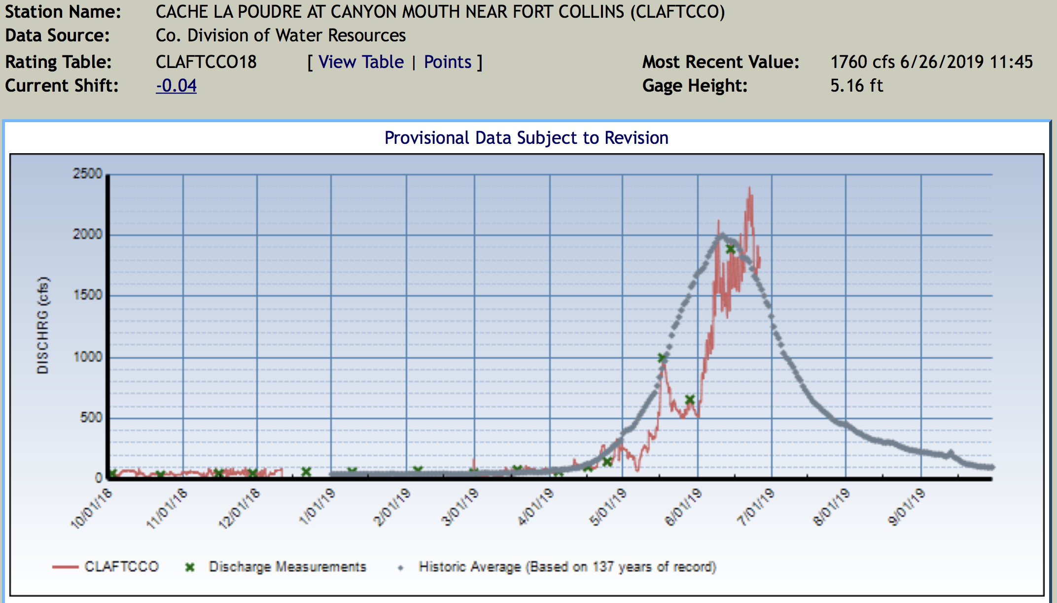
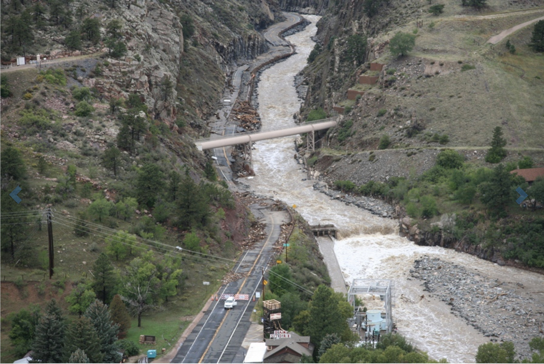
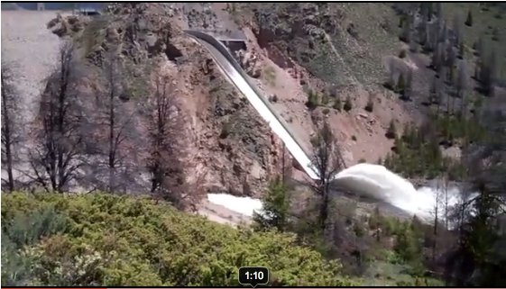
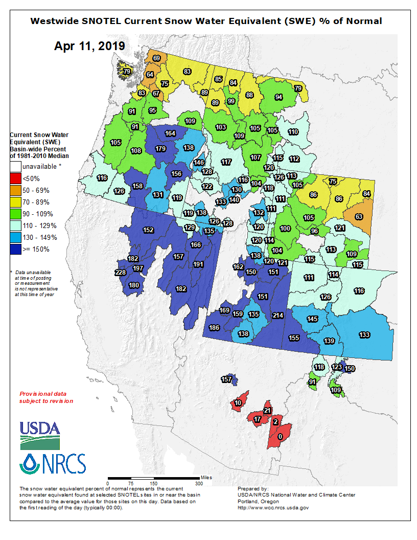


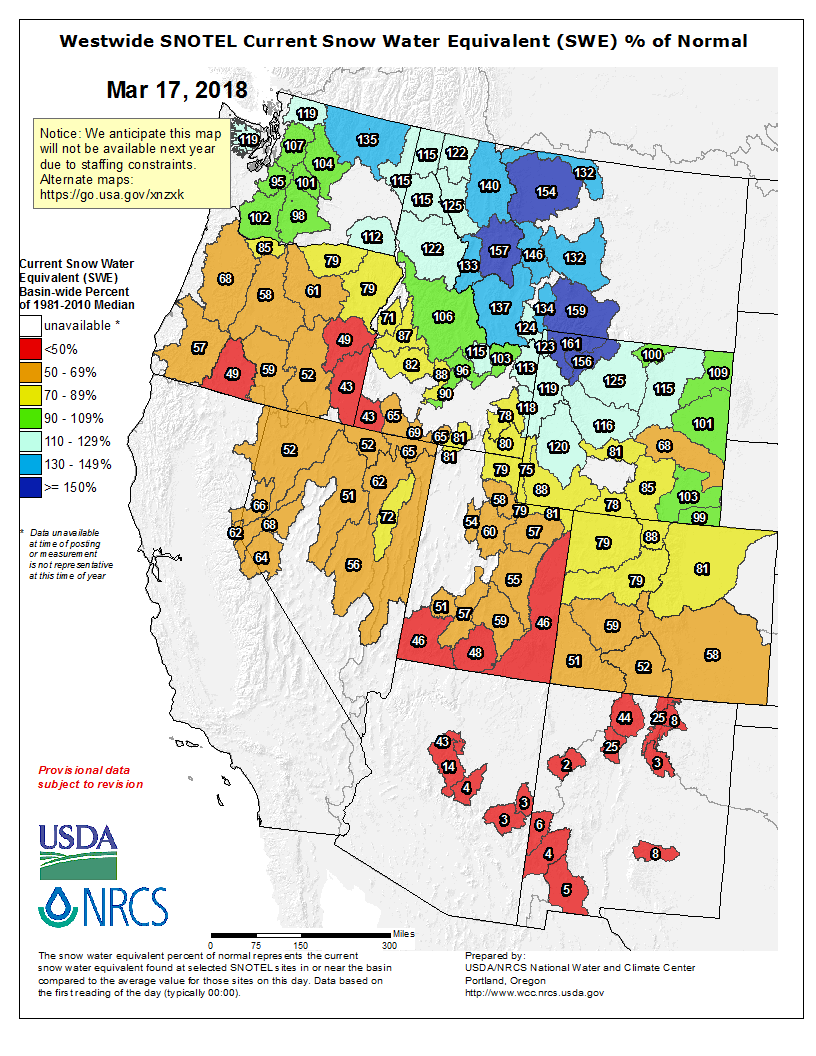

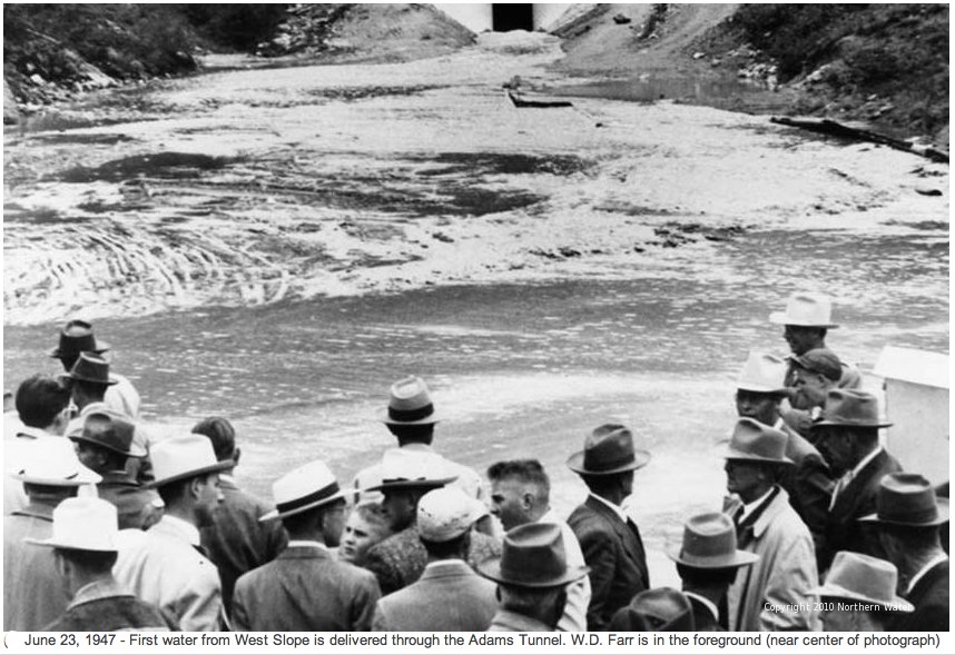
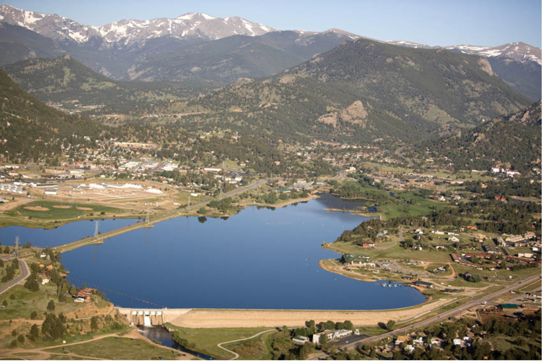

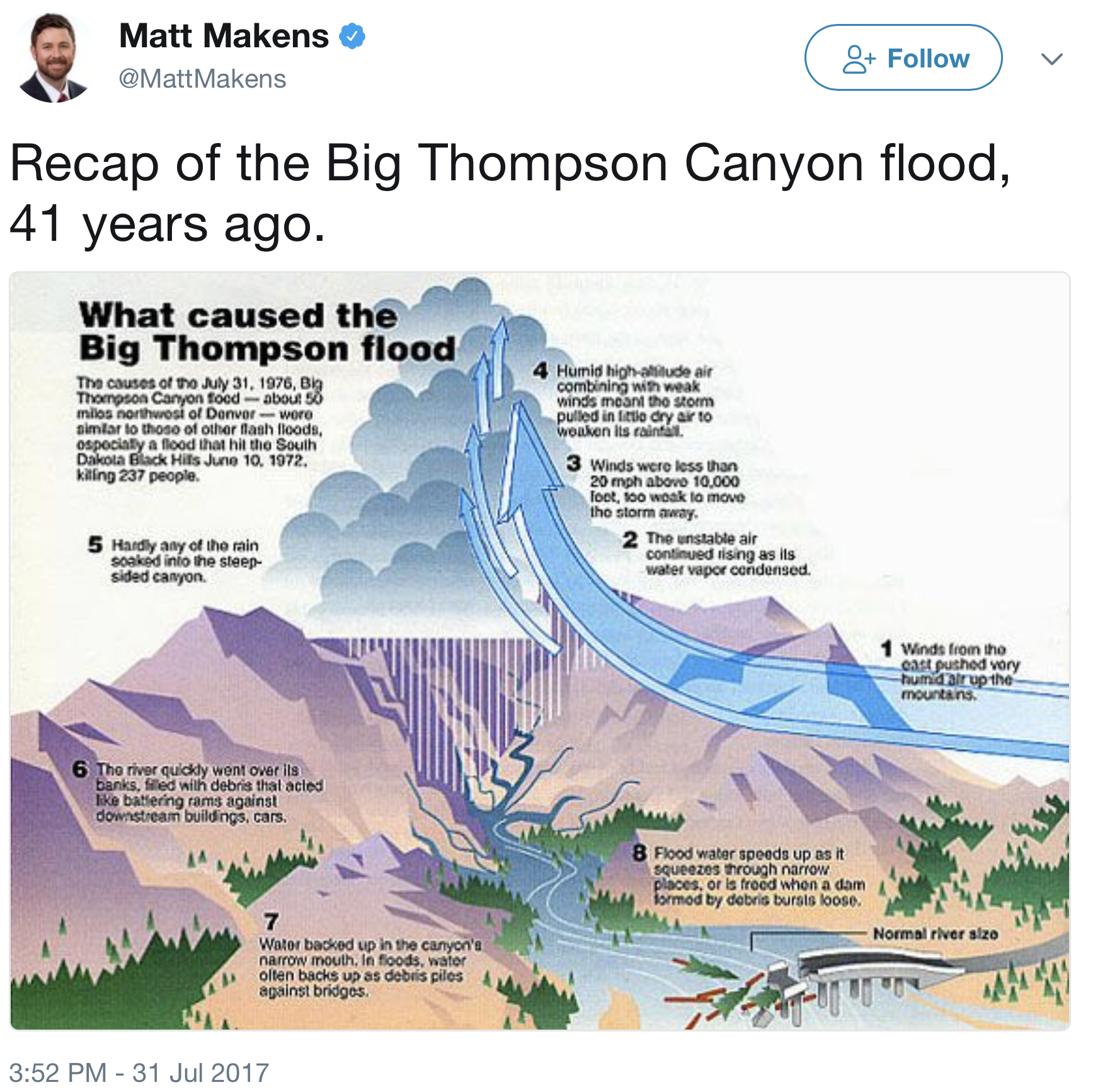
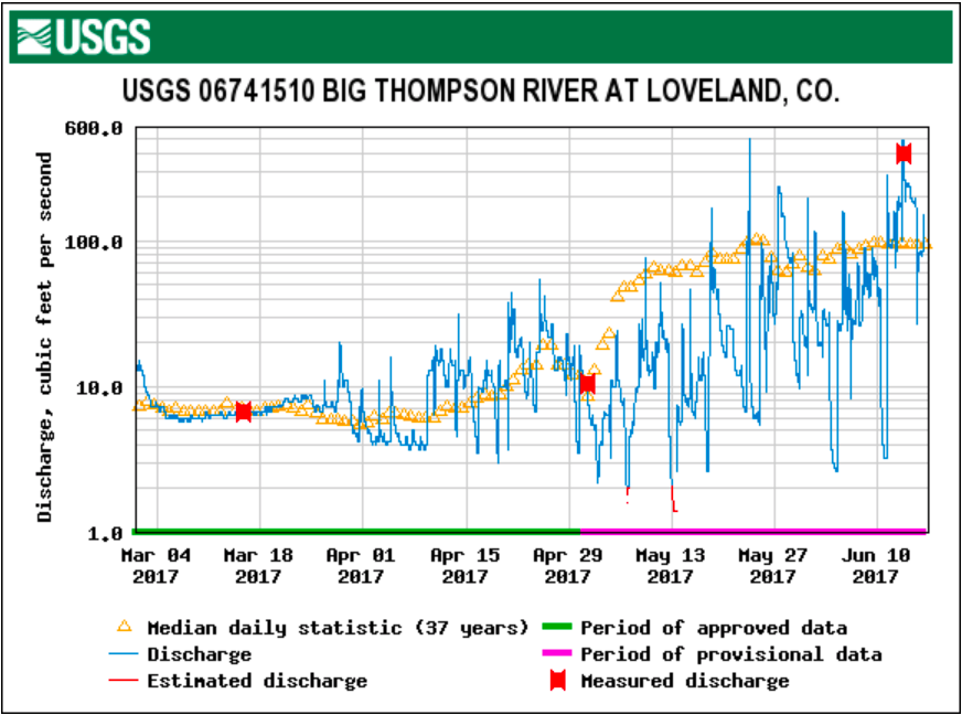


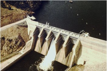
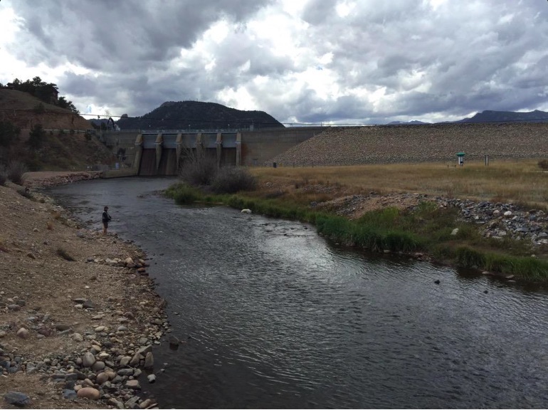
![Scott Hummer, general manager of North Poudre Irrigation Company, talks about how his agency worked with Fort Collins Natural Areas and Colorado Parks and Wildlife to include a fish passage when the irrigation company replaced a diversion structure on the Poudre River that was destroyed by the 2013 floods. Work was completed [in February 2016]. (Pamela Johnson / Loveland Reporter-Herald)](https://coyotegulch.blog/wp-content/uploads/2016/03/cachelapoudrefishpassage022016lovelandreporterheraldscotthummer.png)