This year, actual work will begin to repair habitat along and inside several stretches of the Big Thompson River through a grassroots group, The Big Thompson Watershed Coalition, that formed after the 2013 flood.
“2017 is going to be a big year for projects happening on the ground,” said Shayna Jones, watershed coordinator with the coalition. “We’re talking millions of dollars in river restoration.”
A couple of projects through the coalition have already begun, but several others are going to kick off in 2017. Early in the year, the coalition will put out bids for a contractor to work on a stretch about a mile long from Jasper Lake through Narrows Park, which is in the lower section of the canyon.
Estimated to cost $900,000, the project will include stabilizing sections of the banks, planting vegetation and creating what are called flood plain benches to allow the water space to spread out in the event of a future flood, explained Jones and Tracy Wendt, assistant watershed coordinator.
The work also includes improving fish habitat in several ways, such as building pools within the river and planting vegetation in strategic places to provide shade and cover.
“There will be habitat improvements for all different life stages of trout,” Wendt said. “It’s all the phases of their life to help them.”
Because of the fish habitat component, the coalition, in partnership with Rocky Mountain Flycasters, recently received a $4,500 grant from the Trout and Salmon Foundation. And the Flycasters, a local chapter of Trout Unlimited, also contributed $2,000 to the project.
The bulk of the funding, about $500,000, will come from the Natural Resources Conservation Service with the rest of the money from the Colorado Water Conservation Board, Jones explained.
This piece of the river winds through both private and public properties and ends just before the Narrows near the Colorado Cherry Company.
Other projects also are planned further west along the river with more money coming from the NRCS and the Colorado Water Conservation Board. The exact amounts of money and grants are still being finalized, though Jones did confirm the total work would be in the millions.
Other projects to rehabilitate the river and river corridor are occurring simultaneously including one that will begin in 2017 as a partnership with the coalition and Sylvan Dale Guest Ranch.
Work began in October and will continue this spring on West Creek, and other improvements began two weeks ago on Fox Creek. Both, located along the North Fork near Glen Haven, are being built in partnership with Larimer County, NRCS and the Colorado Water Conservation Board.
Also, Larimer County, private property owners, Colorado Parks and Wildlife and Colorado Department of Transportation officials are working on separate stretches of the river, with everyone working together for overall river benefit.
“We’re making sure our projects are complementing each other to make for an overall healthy watershed,” Jones said.
She expects the work to continue over the next three years as the Colorado Department of Transportation completes the permanent repairs of U.S. 34, which also include massive river restoration work.
As Lyons entered its fourth year of reconstruction following the devastating September 2013 flood, the FBI and U.S. Department of Housing and Urban Development stopped by to seize documents and computers to probe the handling of federal flood-recovery funding.
Communities savaged by the rushing waters have been receiving fund allocations, totaling millions of dollars from several federal sources, such as HUD and the Federal Emergency Management Agency.
Late Friday, Mayor Connie Sullivan released a statement on behalf of the town’s Board of Trustees, stating that the FBI had concluded its portion of the investigation and would not be proceeding with a case.
Also posted to the town’s website was a copy of a subpoena from the U.S. Department of Housing and Urban Development, stating that a focus of its investigation was documents relating to negotiations and grant services contracts between Lyons and Longmont-based Front Range Land Solutions.
Owners of a typical single family home in Arvada will likely have to pay $1.41 more a month — or $16.90 additional a year — for water and sewer services fees in 2017.
The average single-family home is considered to be 3.2 people and a yard. And the average single family drinking water bill in Arvada runs about $481 annually and $291 annually for sewage.
Jim Sullivan, director of utilities for Arvada, said the average single-family account in Arvada uses 120,000 gallons of water each year for domestic and irrigation purposes and generates 60,000 gallons of sewage. Single-family accounts form the largest customer group in Arvada, using about 60 percent of the water.
Arvada City Council heard the proposed rate increases at the Sept. 26 workshop and will discuss the proposals during council meetings on Oct. 3 and Oct. 17, also the date of a public hearing. The rates have been raised every year over the past decade.
When taken separately, the proposed increases amount to 2 percent for water and 3 percent for wastewater. A 1.45 percent increase for water tap fees is also proposed. Stormwater and sewer tap fees are not projected to increase, city officials said.
The increases are needed because of rising vendor prices, new equipment and materials, and employee salary raises, Sullivan said.
Sullivan added that over the next 10 years, water operation costs will likely slowly increase as the city prepares to contribute payment for the Denver Water Gross Reservoir expansion project.
Sources of water
Arvada has two sources of water. The first is a 1965 contract with Denver Water. The second source is the city’s Clear Creek water right holdings.
But “these two sources will not be sufficient to meet the residents’ needs at buildout of the city,” Sullivan said. “The city has entered into an agreement with Denver Water to financially participate in the Gross Reservoir expansion in exchange for additional water supplies. This project should increase Arvada’s water supplies sufficiently to meet the city’s needs at buildout.”
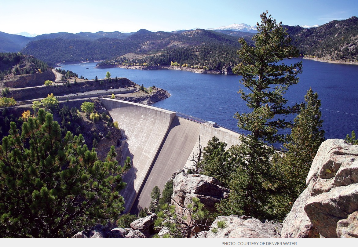
Gross Reservoir, named for Denver Water former Chief Engineer Dwight D. Gross, was completed in 1954. It serves as a combination storage and regulating facility for water that flows under the Continental Divide through the Moffat Tunnel and supplies water to Denver Water’s North System.
The reservoir was originally designed with the intention of future expansion to provide necessary storage.
With demand expected to increase in coming years, expanding Gross Reservoir will increase sustainability to the water supply as part of Denver Water’s multi-pronged approach that includes conservation, reuse water and developing additional supply to meet customers’ future needs.
“We think we have enough money in the fund to avoid issuing debt for this project,” Sullivan told city council.
The proposed 2017 water fund budget is $29 million, with 75 percent going toward water system operations, 8 percent for debt services and 17 percent for capital improvements. The Gross Reservoir project is the majority of the capital improvements area.
The city’s current debt service is $2.2 million, paid mostly from tap fees, Sullivan said. He added that in 2020 the water bonds issued in January 2001 will be paid off.
The projected increase in the operations budget for water is $656,000 or 3 percent. However, the bond repayment in 2020 will reduce operating costs by $445,000 annually. Because of this, city staff is proposing to increase water rates by 2 percent rather than 3 percent in 2017, smoothing out future rate changes.
The proposed 2 percent rate increases the water fee part of the bill by $8.52 annually or 71 cents per month. The 3 percent increase for wastewater amounts to $8.40 annually or 70 cents per month.
It is expected that by 2023, the 20-year program to rehabilitate the sanitary sewer system in the city will end and the $2 million needed annually will drop to $500,000 for major repairs and maintenance.
The water tap fee increase of 1.45 percent applies to new construction and would increase by $275, bringing the total cost of a single family water tap to $19,275.
Denver Water is seeking approvals from the U.S. Army Corps of Engineers, the U.S. Fish and Wildlife Service, and the state of Colorado to expand Gross Reservoir, which is southwest of Boulder. The 77,000 acre-foot expansion would help forestall shortages in Denver Water’s water system and offer flood and drought protection, according to Denver Water.
Considering the Denver region is growing by an average of 4,500 new residents per month, a large sector of the population likely doesn’t remember the catastrophic 2002 drought. The most severe water shortage since the Dust Bowl, snowpack and soil moisture were at all-time lows, and we remained in a dry period until 2006. Luckily, with water restrictions in place, we never actually ran out of water—we just got really close.
“We realized that we had an immediate need to correct a vulnerability in our system,” Denver Water CEO Jim Lochhead says. That’s when Denver Water started planning the Gross Reservoir Expansion Project, and after more than a decade of negotiations, the project (which was recently endorsed by Gov. John Hickenlooper) is underway.
But will it be enough? The short answer is yes—as long as Denverites work on strengthening their water conservation practices. Lochhead was pleased to note that when a storm comes through the Mile High City, there is a noticeable drop in outdoor water use, because well-informed residents are turning off their sprinkler systems. Denver residents have managed to reduce water consumption by more than 20 percent in the last 15 years, even with a 15 percent increase in population, according to Lochhead.
The decrease is not enough to mitigate the risk of drought, however. As Colorado’s largest water utility, the Denver Water system is made up of two collection systems—the Northern and the South Platte—and they are incredibly imbalanced. About 80 percent of the water comes from the south system, leaving the north very vulnerable to low rainfall or wildfires. During the notable dry years of 2002 and 2013, clients in the north end were lucky their taps continued to flow.
“We were literally only one drought away from a major problem in our system,” Lochhead says, noting that as recently as 2013, the system was virtually out of water in the north-end.
Denver Water’s collection system via the USACE EIS
FromThe Grand Junction Daily Sentinel (Dennis Webb):
A proposal to divert Colorado River water to Denver recently has won the endorsement of Gov. John Hickenlooper and the approval of the Colorado Department of Public Health and Environment.
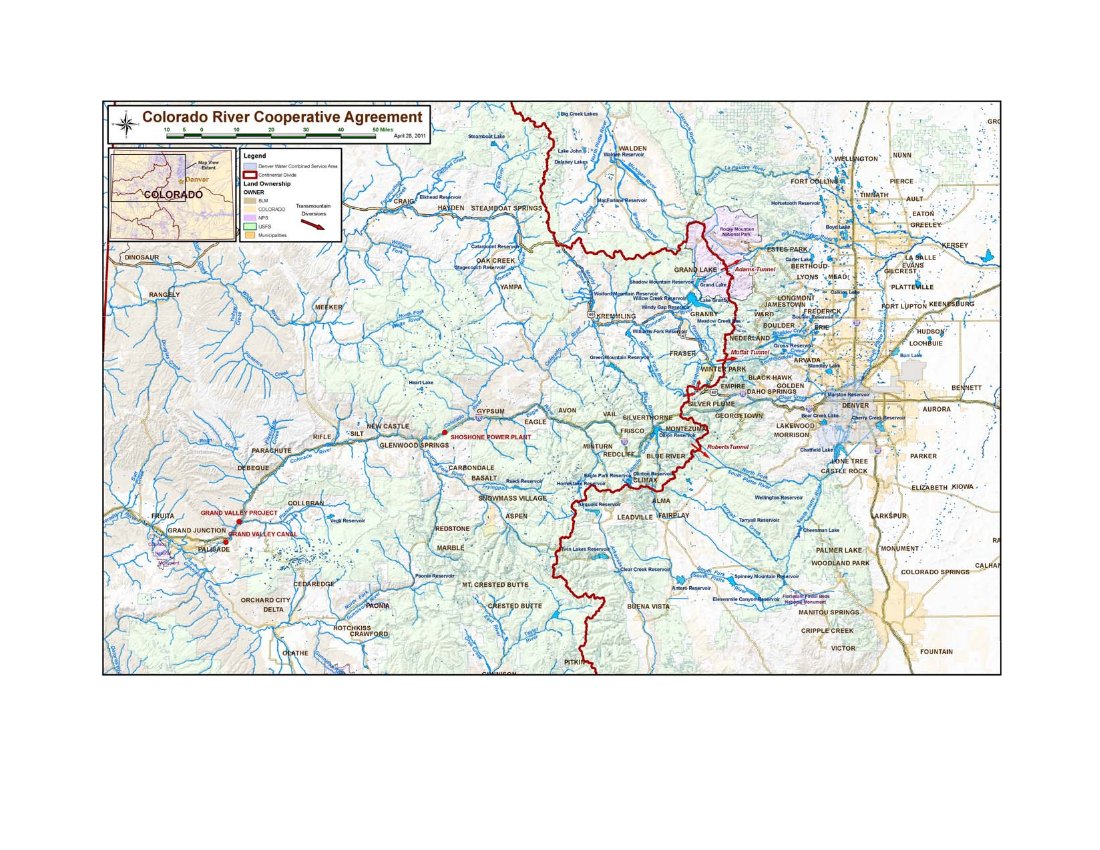
But Denver Water’s Gross Reservoir expansion project may be just as notable for its general lack of opposition west of the Continental Divide. That’s thanks to a wide-ranging agreement, effective in 2013, in which Denver Water obtained concessions including a promise that numerous Western Slope parties to the agreement wouldn’t oppose the expansion project. In return, Denver Water made a number of commitments to the Western Slope.
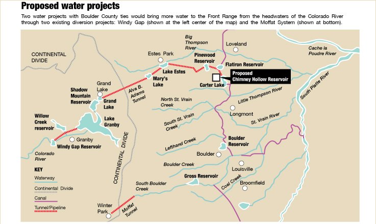
Now Western Slope interests are working on a similar agreement with Northern Water and others on what’s called the Windy Gap Firming Project, which would store Colorado River water in a proposed Boulder County reservoir.
These approaches represent a far cry from how the Western Slope used to respond to transmountain diversion proposals.
“This is the new paradigm. It’s not the old school. In the old school it was like … we’ll see you in court,” said Jim Pokrandt of the Colorado River District, a party to the 2013 Denver Water deal.
For Denver Water, what’s called the Colorado River Cooperative Agreement provided greater certainty for its customers through means such as resolving longtime disputes regarding West Slope water. For the Western Slope, the deal meant dozens of obligations by Denver Water, such as millions of dollars in monetary payments to various entities, protections of Colorado River flows and water quality, a commitment to further water conservation and reuse efforts by Denver Water customers, and a provision aimed at helping assure maintenance of historic flows in the Colorado River even when the Shoshone Power Plant in Glenwood Canyon is not operating. That hydroelectric plant has a senior right helping control flows in the river.
Another key point in that deal is a promise that Denver Water and its customers won’t try to further develop Colorado River water without agreement from the river district and affected counties.
The cooperative agreement has 18 signatories but more than 40 partners, primarily West Slope governments, water conservation and irrigation districts, and utilities. Among them are the Ute Water Conservancy District and multiple irrigation districts in Mesa County.
Pokrandt said the 2013 deal is a win-win for both sides of the Continental Divide.
“That said, yes, more water would be moving east” if the Gross Reservoir project proceeds, he said.
The project, also sometimes called the Moffat Collection System Project, would nearly triple the capacity of the Boulder County reservoir. Denver Water is targeting water in the Fraser River, a tributary of the Colorado.
“Right now there are some periods of time when Gross Reservoir is full at its current size and their water rights are in priority but they can’t take any more water,” Pokrandt said.
The project has an estimated cost of $380 million, and Denver Water hopes to obtain the remaining major permits by the end of next year. CDPHE in June certified that the project complied with state water quality standards, and Hickenlooper endorsed it last week.
“The state’s responsibility is to ensure we do the right thing for Colorado’s future, and this project is vital infrastructure for our economy and the environment,” Hickenlooper said in a news release. “The partnerships and collaboration between Denver Water, the West Slope and conservation organizations associated with this project are just what the Colorado Water Plan is all about.”
That recently adopted plan in some respects took its lead from the Denver Water/Western Slope deal in seeking to address the state’s future water needs in a cooperative rather than confrontational manner statewide.
Pokrandt conceded that not everyone loves the Gross Reservoir proposal…
Trout Unlimited takes a more positive view of the Gross Reservoir project, pointing to its inclusion of a “Learning by Doing” program requiring monitoring of the health of the Fraser River and adjusting operations as needed. The Gross Reservoir proposal envisions drawing water from the Western Slope in wetter years and seasons, but providing the Colorado River watershed with extra water during low flow periods and investing in restoration projects.
“Moreover, Denver Water has entered into partnerships on the Front Range to ensure that the project alleviates chronic low-flow problems in South Boulder Creek. Both sides of the Divide benefit,” David Nickum, executive director of Colorado Trout Unlimited, said in a news release…
Denver Water Chief Executive Officer Jim Lochhead said in a news release, “The Denver metropolitan area is tied to the economic and environmental health of the rest of the state, and Denver Water is committed to undertake this project in a way that enhances Colorado’s values.”
Pokrandt said Western Slope water interests face the reality that under the state Constitution the right to appropriate water shall not be denied if the water can be put to beneficial use and a party can obtain the necessary financing and permitting.
“There’s not a legal stance to say no, so that’s why the river district was even formed in 1937, was to negotiate these things, because no is not an answer in the legal arena because of the Colorado Constitution,” he said.
When it comes to water rights, Pokrandt said, “in the Colorado Constitution, the Continental Divide doesn’t exist.”
This formal backing completes the state’s environmental reviews for the Moffat project, 13 years in the making, clearing the way for construction — if remaining federal permits are issued. Denver Water and opponents from Western Slope towns and nature groups reached a compromise aimed at enabling more population growth while off-setting environmental harm.
It is a key infrastructure project that will add reliability to public water supplies and protect the environment, Gov. John Hickenlooper wrote in a letter to Denver Water manager Jim Lochhead.
It “aligns with the key elements of Colorado’s Water Plan,” Hickenlooper wrote. “Denver Water and its partners further our shared vision for a secure and sustainable water future while assuring a net environmental benefit in a new era of cooperation.”
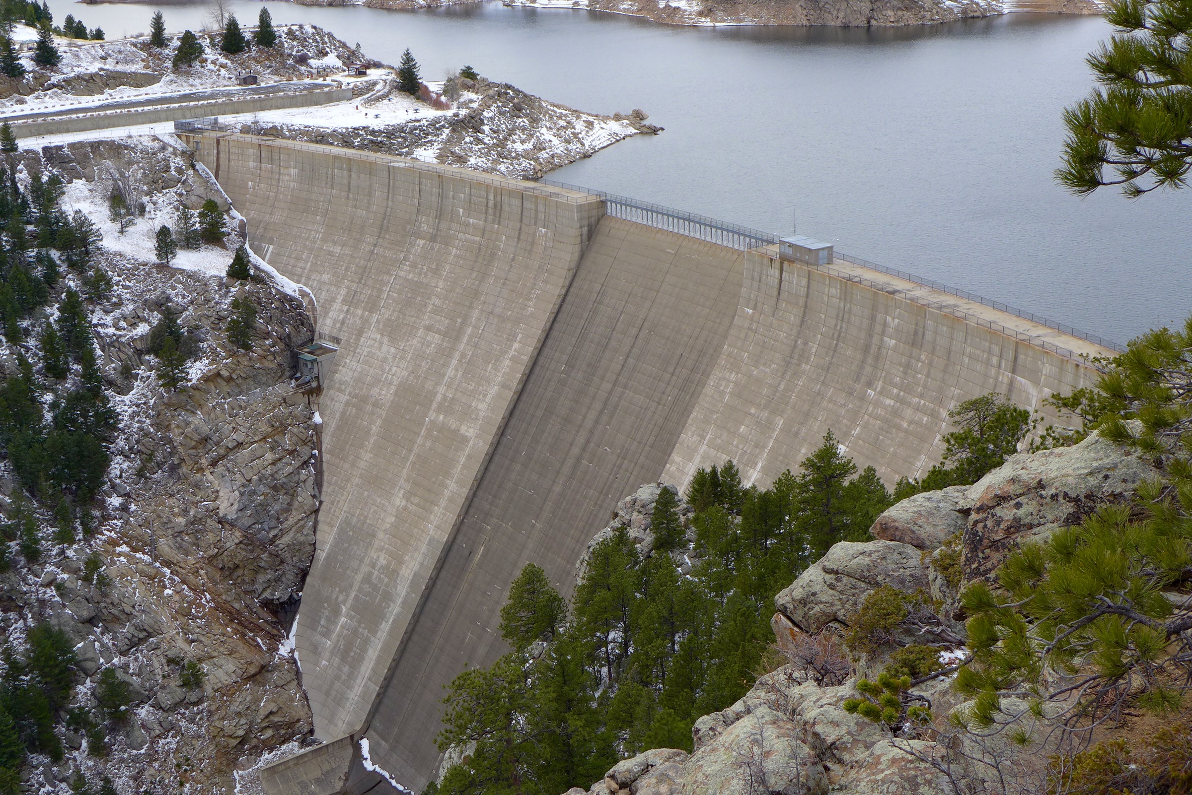
Denver would siphon 10,000 acre-feet a year, on average, more water out of Colorado River headwaters, conveying it eastward under the Continental Divide through a tunnel for more than 20 miles to an expanded Gross Reservoir southwest of Boulder. By raising that reservoir’s existing 340-foot dam to 471 feet, the project would increase today’s 41,811 acre-feet storage capacity by 77,000 acre-feet — more than doubling the surface area of the reservoir…
For more than a decade, Denver Water has been seeking permits, including federal approval for construction affecting wetlands and to generate hydro-electricity at the dam.
“During dry years, we won’t be diverting water. It is a relatively small amount of water. … It is a water supply that Colorado is entitled to develop,” Lochhead said in an interview.
The increased storage capacity “allows us to take water in wet times and carry it over through drought periods. It gives us operational flexibility on the Western Slope. … Having this additional storage enables that flexibility.”
Colorado leaders’ formal endorsement follows a recent Colorado Department of Public Health and Environment decision to issue a water quality permit for the project, certifying no water quality standards will be violated. Hickenlooper has directed state officials to work with federal water and energy regulators to expedite issuance of other permits. Denver Water officials said they expect to have all permits by the end of 2017, start construction 2019 and finish by 2024…
…Trout Unlimited and other conservation groups call the project a realistic compromise considering the rapid population growth along Colorado’s Front Range.
“If the state needs to develop more water, they need to do it in a less-damaging, more responsible way — as opposed to going to the pristine headwaters of the South Platte River, which is what the Two Forks project was going to do,” TU attorney Mely Whiting said.
“We’ve put things in place that will make Denver Water be a steward of the river,” Whiting said. The agreement hashed out between Denver Water and conservationists “does not specifically say they have to tweak the flows to help the environment. It does say they have to monitor, for water temperature and macroinvertebrates. And if there’s a problem, they are responsible for figuring out why and they need to do something about it. It does not say exactly what they have to do but they have to fix any problem.”
Gross Dam enlargement concept graphic via Denver Water
Gov. John Hickenlooper has officially endorsed a project to expand Boulder County’s Gross Reservoir, a move he hopes will improve Colorado’s water capacity for the next several decades.
The endorsement was considered a formality; Hickenlooper wrote to President Barack Obama four years ago, asking for the president’s help in speeding up the process for Gross and other water projects.
Colorado is predicted to face a gap of more than one million acre-feet of water by 2050, according to a 2010 estimate that many believe may be on the low end. One acre-foot of water is the amount of water it would take to cover the field at Mile High Stadium from endzone to endzone with one foot of water. That’s 325,851 gallons of water. The average family of four uses about half an acre–foot of water per year.
Hickenlooper couldn’t give his formal okay for the expansion of the reservoir, which is northwest of Eldorado Springs, until the state’s Department of Public Health and Environment had completed its review that certifies the project would comply with state water quality standards.
At 41,811 acre feet, Gross is among the state’s smallest reservoirs. It’s operated by Denver Water, supplied by water coming from the Fraser River on the west side of the Continental Divide through the Moffat Tunnel.
The expansion would allow the reservoir to collect another 18,000 acre-feet of water, enough to supply 72,000 more households per year. The estimated cost is about $380 million, which includes design, management, permitting, mitigation and construction.
The Gross expansion has been in the works for more than 13 years, with its first permits applied for in 2003. If all goes according to plan, the permitting process will be completed in 2017,with construction to begin in 2019 or 2020. The reservoir could be fully filled by 2025, according to Denver Water spokesman Travis Thompson.
In his letter to Denver Water, Hickenlooper called the Gross project key to serving more than 25 percent of the state’s population. It will “add reliability to our public water supply, and provide environmental benefits to both the East and West Slopes of Colorado,” he said.
Aye, there’s the rub: the Western Slope, whose residents fear that anything that will divert more water from the Western Slope to the Eastern Slope will cut into their water supplies. They also worry that more diversions of Colorado River water will make it more difficult to satisfy multi-state compacts with southwestern states that rely on water from the Colorado River, of which the Fraser is a tributary.
But Jim Lochhead, head of Denver Water, told The Colorado Independent that any further diversions will require buy-in from folks on the Western Slope.
It’s part of an arrangement between Denver Water and 17 Western Slope water providers that has been in development for the past six years, Lochhead said. “We’ve worked extensively with the West Slope to develop the Colorado River cooperative agreement,” which will make the environment and economy of Western Colorado better off, he said.
The agreement addresses impacts of Denver Water projects in Grand, Summit and other counties, all the way to the Colorado-Utah border.
Lochhead hopes the Gross Reservoir project will be a model for cooperation, with benefits for both sides of the Continental Divide.
And the cost? The budget for the agreement starts at $25 million and goes up from there. That first funding goes to Summit and Grand counties for enhancement projects, which includes improved water supply for Winter Park, Keystone and Breckenridge ski areas. Lochhead said the locals will figure out exactly how to spend the money, and that Denver Water isn’t dictating what those counties will do with it beyond setting some parameters for protection of watersheds, the area of land that drains to a particular body of water.
Denver Water has also committed to making improvements to the Shoshone Power Plant on the Colorado River near Glenwood Springs, and improvements to wastewater treatment plants all the way to the western state line to enhance area water quality.
“We have an extensive list of commitments to partner with the Western Slope, to do the right thing,” Lochhead said.
The Gross Reservoir expansion is critical to Denver Water’s future needs, as Lochhead sees it, because its improved capacity will allow the water utility to operate its system with more flexibility. That’s most important for Denver Water’s attention to environmental concerns, both on the Western Slope and for South Boulder Creek, which flows out of Gross Reservoir.
“The state’s responsibility is to ensure we do the right thing for Colorado’s future, and this project is vital infrastructure for our economy and the environment,” Hickenlooper said in a statement today. “The partnerships and collaboration between Denver Water, the West Slope and conservation organizations associated with this project are just what the Colorado Water Plan is all about.”
Added Lochhead in a statement Wednesday: “The Denver metropolitan area is tied to the economic and environmental health of the rest of the state, and Denver Water is committed to undertake this project in a way that enhances Colorado’s values.”
The dam that forms Gross Reservoir, located in the mountains west of Boulder. Photo: Brent Gardner-Smith/Aspen Journalism
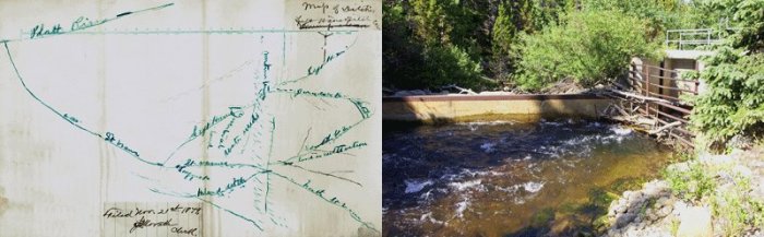
Above, left: This hand drawn map is one of the original documents of Coffin V Left Hand Ditch, at the Colorado State Archives. A few original documents from the Coffin V Left Hand case can be seen at the Colorado State Archives, filed under case #885, #1103 and #1203. Above, right: The headgate of the Left Hand Ditch on the South St. Vrain, where the famous confrontation took place.
People can register to participate in a June 11 Boulder County Parks and Open Space water tour that’s to highlight the 150th anniversary of the Left Hand Ditch Company.
The 7:30 a.m. to 2:30 p.m. tour will begin at the Plaza Convention Center, 1850 Industrial Circle, Longmont, and start with presentations on water law, the orientation of the overall Left Hand basin and the history of the Left Hand Ditch.
Tour buses will then visit stops at sites in the Left Hand Ditch system before returning to the Plaza Center. The water tour, which will include a light breakfast and lunch, will cost $20 per participant.
The 2016 Water Tour is supported by Boulder County Parks and Open Space, Boulder’s Open Space and Mountain Parks, the St. Vrain and Left Hand Water Conservancy District and Left Hand Water District.
Boulder County Commissioners Elise Jones and Deb Gardner signaled their support Thursday for a $53.8 million package of road, bridge, transit and trails spending, and equipment and vehicle purchases, that the county Transportation Department has proposed for this year.
Transportation Director George Gerstle spent much of his presentation of that overall 2016 capital improvements program focusing on the $29.9 million expected to be spent by the end of the year on the latest set of repairs and replacements of roads and bridges destroyed in the September 2013 floods.
“Road and bridge flood repairs are dominating the program in 2016,” Gerstle said.
Officials have estimated that flood damages to Boulder County’s transportation network amounted to $120 million, and work on emergency, and then temporary, and then permanent, repairs has been underway for more than 2 ½ years.
If things proceed as planned the rest of this year, by the start of 2017, Boulder County should have completed or at least started construction on between $50 and $70 million worth of transportation flood-recovery projects, Gerstle said.
Already, during the first quarter of 2016, about $11 million in such flood-recovery transportation projects are being constructed, Gerstle told the commissioners.
The Board of County Commissioners is expected to formally vote to adopt the Transportation Department’s Capital Improvement Program during one of the board’s regular business meetings next Tuesday or Thursday.
Environmentalists are rallying support for a renewed fight against a long-standing proposal from Denver Water to nearly triple the capacity of Gross Reservoir by diverting from the Colorado River Basin…
Before a group of about 30 Monday night at Shine Restaurant and Gathering Place, the directors of two non-profits united in the fight against the expansion — Save the Colorado River and The Environmental Group — made presentations alleging impropriety on Denver Water’s part and soliciting donations to a legal fund.
“They’ve been working on their decision, and we assume, feel very strongly, that (Army Corps) will issue the permit,” said Chris Garre, President of The Environmental Group, which is based in Coal Creek Canyon. “As soon as that happens, the clock starts ticking.”
The Colorado River, the presenters said, is the most dammed and diverted on the planet. At the Colorado River Delta, there is no longer water, and there is concern that an expansion of Gross Reservoir would see some creeks and tributaries drained at the 80 percent level, with some “zero flow” dry days.
An expansion of Gross Reservoir, which is a roughly 25-minute drive west from Boulder on Flagstaff Road, would have a significant local impact. In fact, it would be the biggest construction project in Boulder County history, and would likely take about four or five years to complete.
The proposal seeks to increase the height of the dam by 131 feet, and would require the clearing of about 200,000 trees…
“Caring for the environment,” Garre added, “particularly those who live in the environment, in the forest, is crucial to your experience in Boulder County. This has never been addressed by Denver Water. It’s been ignored.”
While the universal downsides such major construction — noise and temporary aesthetic downgrade, among others — aren’t up for debate, Denver Water tells a very different story about the project.
The public agency that serves 1.3 million people in the Denver metro area gets about 80 percent of its water from the South Platte River System, and another 20 percent from Moffat, a smaller clump up north. Expanding Gross Reservoir and thereby Moffat, Denver Water says, will help balance the existing 80/20 split.
“This imbalance makes the system vulnerable to catastrophic events, such as the Buffalo Creek and Hayman fires, which caused massive sediment runoff into reservoirs on the south side of our system,” the agency published on its website.
During times of severe drought, the argument continues, “We run the risk of running out of water on the north end of our system,” which would primarily impact customers in northwest Denver, Arvada and Westminster.
Denver Water also maintains that as the Front Range continues to be one of the country’s fastest-growing areas, a shortfall in water supply is imminent unless addressed through projects like the one pitched for Gross Reservoir.
Eldorado Springs, Colorado, has won the top prize for U.S. tap water at an international tasting contest.
The judges gave out two gold medals for Best Municipal Water on Saturday at the 26th annual Berkeley Springs International Water Tasting in West Virginia. They awarded the top prize among U.S. entries to Eldorado Springs, while Clearbrook, British Columbia, won first place for best in the world.
The award for best purified water went to Bar H2O of Richmond, Michigan.
An entry from Karditsa, Greece, Theoni Natural Mineral Water, won the top prize for bottled water, while the best sparkling water was awarded to Tesanjski Kiseljak of Tesanj, Bosnia.
Ten judges tasted and selected from among dozens of waters from 18 states, seven Canadian provinces and five foreign nations.
Here’s the release from the University of Colorado at Boulder:
New research led by the University of Colorado Boulder indicates an ongoing loss of ice on Niwot Ridge and the adjacent Green Lakes Valley in the high mountains west of Boulder is likely to progress as the climate continues to warm.
The study area encompasses the Niwot Ridge Long-Term Ecological Research (LTER) site, thousands of acres of alpine tundra, subalpine forest, talus slopes, glacial lakes and wetlands stretching to the top of the Continental Divide in the Rocky Mountains. The Niwot Ridge LTER site, which includes Green Lakes Valley and CU-Boulder’s Mountain Research Station (MRS), is one of 26 North American LTER sites created and funded by the National Science Foundation (NSF) and one of the initial five LTER sites designated by the federal agency in 1980.
The decline of ice at the Niwot Ridge LTER site appears to be associated with rising temperatures each summer and autumn in recent years, said CU-Boulder Professor Mark Williams of the Institute of Arctic and Alpine Research, lead study author. The decline is especially evident on the Arikaree glacier — the only glacier on Niwot Ridge — which has been thinning by about 1 meter per year for the last 15 years.
“Things don’t look good up there,” said Williams. “While there was no significant change in the volume of the Arikaree glacier from 1955 to 2000, severe drought years in Colorado in 2000 to 2002 caused it to thin considerably. Even after heavy snow years in 2011 and again in 2014, we believe the glacier is on course to disappear in about 20 years given the current climate trend.”
The new study looked at changes in the cryosphere — places that are frozen for at least one month of the year– at the Niwot Ridge LTER site going back to the 1960s. In addition to the changes occurring on the Arikaree glacier, the researchers also have seen decreases in ice associated with three rock glaciers (large mounds of ice, dirt and rock) as well as subsurface areas of permafrost – frozen soil containing ice crystals.
The team used several methods to measure surface and subsurface ice on Niwot Ridge: ground-penetrating radar, which measures ice and snow thickness; resistivity, which measures the conductivity of electrical signals through ice; and seismometers to measure signals bounced through subsurface ice. “We found that a combination of all three methods provided the best picture of changing snow and ice conditions on Niwot Ridge,” said Williams.
The researchers also discovered an increased discharge of water from the Green Lakes Valley in late summer and fall after the annual snowpack had melted, a counterintuitive trend that began in the early 1980s, said Williams. The increased discharge appears to be due to higher summer temperatures melting “fossil” ice present for centuries or millennia in glaciers, rock glaciers, permafrost and other subsurface ice.
“We are taking the capital out of our hydrological bank account and melting that stored ice,” he said. “While some may think this late summer water discharge is the new normal, it is really a limited resource that will eventually disappear.”
Scientists have been gathering information on the snow, ice and plant and animal abundance and diversity on Niwot Ridge going back to the 1940s, when CU-Boulder Professor John Marr and colleagues began studies. The two highest climate stations on Niwot Ridge, one at 10,025 feet and the other 12,300 feet, have been monitoring data continuously since 1952.
“This study demonstrates declines in ice — glaciers, permafrost, subsurface ice and lake ice in the Niwot Ridge area over the past 30 years,” said Saran Twombly, LTER program director in NSF’s Division of Environmental Biology, which funded the research. “Long-term research at Niwot Ridge offers a rare opportunity to document the continuous, progressive effects of climate change on high alpine ecosystems, from ice and nutrients to plant and animal communities.”
A special issue of the journal Plant Ecology and Diversity that includes several research papers involving CU-Boulder faculty and students is being published this month. Study co-authors on the Niwot Ridge snow and ice paper, part of the special issue, include emeritus Professor Nel Caine of CU-Boulder, Professor Matthew Leopold of the University of West Australia and professors Gabriel Lewis and David Dethier of Williams College in Williamstown, Massachusetts.
From an ecological standpoint, Niwot Ridge has seen a significant increase in alpine shrubs above treeline in recent decades, said Williams. At one research site known as “The Saddle” at about at 11,600 feet in elevation and 3.5 miles from the Continental Divide, the ecosystem has gone from all tundra grasses and no shrubbery in the early 1990s to about 40 percent shrubs today.
“Places that once harbored magnificent wildflowers in this area are being replaced by shrubs, particularly willows,” he said. “The areas dominated by shrubs are increasing because of a positive feedback – patches of these shrubs act as snow fences, causing the accumulation of more water and nutrients and the growth of more shrubs.”
One nutrient, nitrogen — produced primarily by vehicle emissions and agricultural and industrial operations on the Front Range and elsewhere in the West — is being swept into the atmosphere and deposited on the tundra in increasing amounts, said Williams. Nitrogen deposition also is an issue in nearby Rocky Mountain National Park.
Niwot Ridge is part of the Roosevelt National Forest and has been designated a United Nations Educational, Scientific and Cultural Organization (UNESCO) Biosphere Reserve. The Green Lakes Valley is part of the City of Boulder Watershed and CU-Boulder’s MRS is devoted to the advancement of mountain ecosystems, providing research and educational opportunities for scientists, students and the general public.
To view a video on snow, ice and water research on Niwot Ridge visit this CU-Boulder climate website and click on “Water: A Zero Sum Game.” For more information on the Niwot Ridge LTER program and CU-Boulder’s Mountain Research Station visit this CU-Boulder webpage.
Ongoing or in-the-pipeline projects could cost as much as $76.8 million in 2016. Most of these projects are aimed at repairing the September 2013 floods’ damages to county roads, bridges, parks, open space areas — as well as services and programs to assist Boulder County residents and property owners still recovering from the floods.
That estimate, from a recent county staff report to the Board of County Commissioners, would be on top of more than two years of flood recovery spending that’s expected to have totaled nearly $97.9 million by the end of this year.
And 2016 won’t be the final year that county officials expect to devote a major portion of their spending on flood recovery.
The county staff is sticking by its late 2013 estimates that flood recovery projects and services will have a total cost of more than $217 million by the time they are completed, so another $43.2 million might be needed beyond 2016.
EPA spokeswoman Laura Williams said the agency is continuing to investigate samples taken from the creek to see whether the metal content in the water is higher than historic levels.
Officials said that samples collected did not show the presence of some of the metals the EPA tests for, but, as of Monday, they had not explained what metals were present in the samples and in what concentration.
The tests look for aluminum, antimony, arsenic, barium, beryllium, cadmium, calcium, chromium, cobalt, copper, iron, lead, manganese, magnesium, nickel, potassium, selenium, silver, sodium, thallium, vanadium and zinc.
The deluge of water from the Swathmore Mine on Sept. 21 temporarily turned the creek orange and led officials to briefly shut down water intake systems downstream.
Boulder and Nederland use the creek as part of their water supplies.
EPA officials said soon after the spill that the discharge from the mine was not toxic, but sent water samples for testing. They expect further results to be available later this week.
Todd Hartman, a spokesman for the Colorado Department of Natural Resources, said the mine has discharged at a “low flow rate,” less than 15 gallons a minute, for as long as the landowner can remember, but had apparently never surged before…
The Colorado Division of Reclamation, Mining and Safety has identified six old or abandoned mining sites in the county that impact water quality or likely do: Bueno, Emmett, Evening Star, Fairday, Captain Jack and Golden Age.
Four of the mines — Bueno, Emmett, Evening Star and Fairday — likely impact water quality, but currently have no active water treatment programs, records show.
Hartman said the six mines are designated as “legacy mines” because they were mined prior to modern mining reclamation laws that came into effect in the 1970s.
The Captain Jack Mill is designated as a Superfund site because of multiple contaminants, including lead, arsenic and thallium, along with several other heavy metals, according to the EPA.
Mary Boardman, a project manager with the Colorado Department of Public Health and Environment, said the Captain Jack Mill Superfund Site was added to the national priorities list in 2003 and a decision was made to begin clean-up in 2008. That project remains ongoing.
Hartman said the Golden Age Mine is still in the investigative stage, so officials can determine the best approach to managing it.
Boulder County has several waterways deemed “mine related impaired streams” and one state-run “nonpoint source mine reclamation project” that includes removing mine tailings, waste piles and restoring streams, according to the Colorado Division of Reclamation, Mining and Safety.
Hartman said “mining impacted” means the streams have been degraded by acidity or metals from a combination of mining sources and natural background geological sources in such a way that they fall below Clean Water Act Standards.
He said it’s difficult to determine how many old or abandoned mines are in Boulder County, but nearly 1,200 safety closures have been conducted in the last 25 years, and the owner of Swathmore Mine has asked that one be installed by the Colorado Division of Reclamation, Mining and Safety.
“Those are grates and other measures to prevent people and animals from entering (or) falling into old mines,” Hartman said.
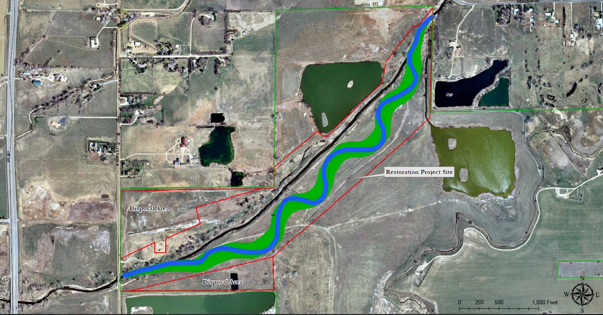
Lower Boulder Creek Restoration site map via Boulder County Open Space
Here’s the release from the US Army Corps of Engineers (Omaha District):
The U.S. Army Corps of Engineers, Omaha District, in partnership with the Boulder County Parks and Open Space Department, will hold a groundbreaking ceremony to celebrate the start of construction of an ecosystem restoration project along an approximately one-mile stretch of Lower Boulder Creek. The ceremony will take place on Thursday, October 8, starting at 12:30 p.m. MDT at the project site, which is located between N 109th Street and Kenosha Road in Boulder County approximately 3.5 miles west of the Boulder County-Weld County line and 8 miles east of the city of Boulder. Limited parking will be available along the Boulder County property access road located just east of the 109th Street Bridge. See attached map. In case of inclement weather, the ceremony will take place at the Goodhue Farmhouse located at the Carolyn Holmberg Preserve, 2009 S. 112th Street, Broomfield, Colorado.
BACKGROUND: Lower Boulder Creek once meandered across a broad floodplain that supported numerous wetlands, streamside vegetation, and associated native fish and wildlife populations. Since European settlement, the project reach and its associated habitats have been dramatically degraded by activities including upstream development, water diversions, pollution, non-native species, and gravel mining. During past on-site mining activities, the project reach of Lower Boulder Creek was channelized, and earthen levees were constructed along portions of its banks, thus disconnecting the channel from its historic floodplain and creating an impoverished stream and riparian environment. The project area is currently in a highly degraded state, which without active ecological restoration would take decades or longer to improve.
In 2011, the Omaha District completed a feasibility study which identified a feasible project to restore habitat for migratory birds and other wildlife, restore wetland and stream values, reduce invasive species and provide other ecosystem improvements. A construction contract was awarded to American West Construction LLC of Denver, Colo. for $2.6 million, which includes realigning the one-mile section of Lower Boulder Creek to restore natural meanders, in-stream habitat, and the creek’s floodplain and planting native riparian, wetland, and upland grasses, forbs, trees and shrubs along the stream and within the floodplain to greatly improve wildlife habitat. The project is expected to be complete by Fall 2016.
Click here to go to the Boulder County Open Space website for all the inside skinny.
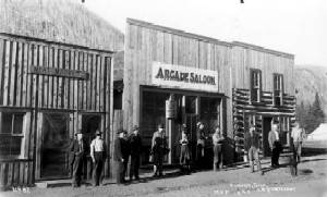
The Arcade Saloon in 1898 Eldora Colorado via WikiPedia From the Longmont Times-Call (John Bear):
Officials believe 4,500 gallons of orange water that leaked from an old Eldora-area mine into a creek Monday — prompting the shutdown of water intake systems downstream — is not toxic, but they’re still awaiting further test results.
Environmental Protection Agency spokeswoman Lisa McClain-Vanderpool said Tuesday that the agency collected water samples to test for heavy metals associated with mines and expects the results in the next few days.
McClain-Vanderpool said other tests conducted Monday showed the pH balance in the water — which would be affected by the presence of heavy metals — appeared to be within normal ranges.
Boulder County spokeswoman Carrie Haverfield said a county hazardous materials team and Nederland town officials also tested the water Monday and didn’t find anything that raised alarms.
Haverfield said that Boulder County is full of old mines, so some amount of seepage is likely.
“We did call in the proper resources and take the proper precautions we needed to take to ensure the safety of our residents,” Haverfield said.
McClain-Vanderpool added that the EPA and state mining and health officials visited the site Tuesday morning and are continuing to support local responders…
County officials responded to the area Monday after a plug came loose from the historic Swathmore mine, located near the 900 block of Bryan Avenue in the Eldora townsite.
Orange water flowed from the opening for about two-and-a-half hours on Monday, and officials temporarily shut down water intake systems for Nederland and Boulder while they tested the water.
A news release said county officials had been previously made aware of seepage from the mine.
The creek appeared orange on the bottom Tuesday afternoon, and a small culvert that runs into the creek was still full of rust-colored water and mud.
Evans Colorado September 2013 via TheDenverChannel.com
FromThe Denver Post via the Loveland Reporter-Herald (Joey Bunch/John Aguilar):
As Colorado hits the two-year mark since a historic deluge swelled rivers and creeks to overflowing, killing 10 and causing nearly $4 billion in damage across 24 counties, frustration is a theme for a surprisingly large group of folks still dealing with the storm’s aftermath. Hundreds of mobile home park residents in Evans, a city of 20,000 south of Greeley, are unable to return to communities that have been effectively scraped off the map.
The major access road into Glen Haven is still being put back together, causing repeated daily hour-long delays that result in unending headaches for locals and drive away tourist traffic headed to or from nearby Estes Park.
Only three of 17 homes in James town destroyed by a manic James Creek have been completely rebuilt, and a part of the population has relocated or hasn’t yet moved back to the tiny mountain town.
And then there are the dozens of Lyons residents, locked in a seemingly endless bureaucratic arm-wrestling match with town officials over attempts to get permits to rebuild their homes.
They confronted town leaders at a public meeting earlier this month demanding a more streamlined process for evaluating and approving their engineering and hydrology plans so they can move forward.
“We’ve spent a lot of money on this project, and we haven’t laid a shovel in the ground,” said Kitty Wang, who with her husband has lived in Lyons for 13 years and still awaits a floodplain development permit for a new house. “It’s a nightmare we keep trying to wake up from.”[…]
Molly Urbina, the state’s chief recovery officer, acknowledged that despite the billions spent to make repairs and provide compensation to victims of Colorado’s most costly natural disaster, problems remain.
The state, she said, has not forgotten about those still suffering.
“When we talk about disasters, we talk about a marathon, not a sprint,” Urbina said. “We continue to coordinate with local communities to assess and evaluate needs and priorities and to advocate for additional resources.”
Some of those resources have come from groups like Foothills United Way in Boulder County, which has raised $4.9 million in donations and spent about $363,000 for mental health services. The charity still sits on nearly $2 million to help cover the costs of at least 333 open cases in Colorado’s hardest-hit county…
Urbina said estimating costs for a disaster the size of the 2013 floods, which destroyed 1,852 homes and 203 businesses and created more than 18,000 evacuees over a five-day period starting Sept. 10, 2013, is a “complex, long-term process.”
“We understood that this would evolve as recovery priorities and projects became more clear,” she said.
The dynamic nature of the floods’ impact has played out in dramatic fashion since the one-year anniversary, with the cost of rebuilding in Colorado swelling by a third to nearly $4 billion.
The $1 billion spike, Urbina said, reflects the fact that initial cost estimates done in the months following the flood were rough. In the past year, more detailed estimates of what it would cost to fully repair and restore roads and watersheds in the state were made.
Specifically, watershed recovery master plans performed over the last year revealed that the true cost of improving flood-impacted watersheds would amount to some $600 million.
Last February, Gov. John Hickenlooper announced $56.9 million will come from a federal program to help restore stream corridors and prevent future flooding.
The remainder of the increased cost estimate since last year — around $400 million — came about as the result of detailed design and engineering work, which more clearly outlined the cost of building roadways that can better withstand future flooding, Urbina said.
Work will begin soon to redesign U.S. 36 from Estes Park to Lyons at an estimated cost of $50 million.
Also, individuals and local governments have found damage they initially didn’t know about or thought private insurance would cover, according to the Colorado Resiliency and Recovery Office…
A new normal is also being pieced together in Evans, where the Eastwood Village and Bella Vista mobile home parks were turned from once-vibrant low-income neighborhoods to empty, weed-choked lots by the floods. It’s not certain what will happen to the two properties, though Bella Vista’s owner is working with the city to re-establish itself at the same spot on 37th Street.
Here’s a look at several survivors from Isa Jones and Pam Mellskog writing for the Longmont Times-Call via the Loveland Reporter-Herald.
Meanwhile the Big Dam repairs are nearly complete. Here’s a report from Saja Hindi writing for the Loveland Reporter-Herald. Here’s an excerpt:
Crews are putting the finishing touches on repairs to the Nelson Big Dam and expect to have them completed in the next few weeks.
The masonry arch dam, built in 1895, is located west of Loveland’s water treatment plant, and was significantly damaged in the September 2013 flood.
The dam diverts raw water to the city’s water treatment plant, provides drinking water for the Johnstown water treatment plant, and irrigates about 20,000 acres of farmland in Larimer and Weld counties.
The Consolidated Home Supply Ditch and Reservoir Co. owns the 60-foot-plus dam, which didn’t suffer major damages in the 1976 flood, but the 2013 waters left a lot of damage.
The dam is also identified as a Colorado Historic Civil Engineering Landmark, so crews had to make sure not to change the historic aspects of the dam substantially. That included using stones from the same quarry as the original stones.
Crews are working on Phase II of repairs now, according to Home Supply board member Gary Gerrard, which encompass the pointing or refacing of the dam (grouting stones on the face of the dam), a need caused by years of erosion. Once that’s completed, he said, crews will close the gate.
The dam was operational April 1, 2014, in time for the spring runoff, and repairs continued while it was in use, aside from taking a break in the winter months…
Some of the repairs after the flood damaged the dam, Gerrard said, included restoring the crest elevation, mitigating future flood effects by strengthening the dam with concrete abutments and installing a new spillway that configures water to go around instead of on top and updating to 21st century technology such as an automatic gate that fluctuates with river flow.
Because the flood damaged the dam’s main gate, the company was also able to replace other gates not damaged by the flood that were almost unusable and rusting because they were first put in 1915.
Funding for the repairs came from the city of Loveland, the Home Supply board, the Colorado Water Conservation board and the Federal Emergency Management Agency. The city committed to paying 50 percent of the costs not covered by federal and state grants. The conservation board committed to covering uncovered costs through long-term low-interest loans.
The total cost of repairs, Gerrard said, is about $3 million. Of that, $2.2 million is expected to be covered by federal aid.
Gerrard said the entities were able to keep costs low through “the methods of construction and the ability we had to be able to make decisions in the field, and the cooperation we had from all the entities to react to the things we found out in the field.”
Because officials could make decisions quickly, there weren’t a lot of construction holdups, he said.
“That’s the main thing to reach out for help. They (Larimer County Long Term Recovery Group) connect you with the people you need (Loveland Housing, in particular). We had volunteers from Lyons, Minnesota, Wisconsin, Florida,” said Aleta.
Today, the Hammond’s have a little less privacy. The flood took out about half the trees and bushes along this road. And what was a pasture with a barn now looks like an outcropping of rocks.
That creek that once rushed with danger is nearly dry, but the family’s gratitude is overflowing.
People lost their homes, a few lost their lives. So we were very, very fortunate,” said Aleta…
The state repositioned U.S. 36 and Little Thompson River to prevent a tragedy like this from ever happening again.
The Hammonds say they still have work to do on their property, like foundation work, and cleaning off grit inside tools and motorcycles.
From the Loveland Reporter-Herald (Jessica Benes):
Where the Little Thompson River used to be 70 feet wide in places, it was blasted to 300 yards, according to Gordon Gilstrap of the Little Thompson Watershed Restoration Coalition.
The September 2013 flood devastated areas along Front Range rivers and streams, and while not nearly as many houses were lost on the Little Thompson River, landowners still are recovering from the deluge that destroyed vegetation, wildlife habitat and landscapes.
Some landowners along the Little Thompson call it “the forgotten river.”
“It’s been an interesting journey,” said Gilstrap, who helped set up the Little Thompson Watershed Restoration Coalition after the flood. “The Little Thompson has been an unknown river because no county or state roads run along it for any distance. It is all privately owned.”
Deirdre Daly, president of the coalition, said that because the river isn’t in a town or county that is leading the charge for river repair, the restoration has been almost entirely driven by the people who live on it…
The Little Thompson headwaters come in from several areas but are mostly above Big Elk Meadows below Estes Park, separate from the Big Thompson.
“It was a small working river,” Gilstrap said. “It provides drinking water to Big Elk Meadows and Pinewood Springs, irrigation to a lot of farmland. It has always been a small, quiet little river.”
The water pushed woody debris down the river, knocking out everything for hundreds of feet on both sides of the river.
Gilstrap said the land along the river was heavily wooded, with a lot of wildlife habitat, especially in the Big Elk Meadows, Pinewood Springs and Blue Mountain areas. Much of that habitat area was lost.
The number of homes lost in the flood was small — two to four — but there was a lot of other damage such as water in basements, homes partially damaged and agricultural fields that were made useless with sediment and garbage debris accumulation.
“A lot of agricultural equipment was lost, and the irrigation ditches took a real hit,” Gilstrap said. “An interesting fact most people don’t know is the Little Thompson was the river that shut down every county bridge between Big Elk Meadows and Milliken — seven public bridges and many other private bridges — so it cut off Northern Colorado from southern Colorado.”[…]
Watershed coalition
Gilstrap helped found the Little Thompson coalition in December 2013, starting with nothing. The group had no money and no knowledge of how to run a coalition.
“Thanks to an amazing group of volunteers that stepped forward to be a part of it, we established the Little Thompson coalition as one of the most effective coalitions in Colorado,” Gilstrap said.
With grant funding, the coalition oversaw the successful completion of a master plan for the watershed, started having meetings, published an active website and Facebook page and coordinated volunteer projects.
“We secured over $1.2 million in government and private-sector grants with a potential of $3 plus million to come,” he said.
The coalition also was able to hire a full-time watershed coordinator, Keith Stagg, and assistant coordinator. Erin Cooper, this summer to oversee grant raising and volunteers, which meant the hard workers such as Gilstrap who had volunteered so much of their time were able to step back.
“We all learned together (at the beginning),” Gilstrap said. “We even learned to say ‘fluvial geomorphic transition’ and other big words like that.”
He said there were two reasons for their success: the volunteers who stepped forward to be on committees while also working day jobs, and support from the state and counties involved.
“Everyone worked together, and that spirit is ongoing more than ever. The volunteers came in from everywhere and did the dirtiest, grungiest work imaginable and were happy as can be if you gave them water and cookies,” he said.
Work still to be done
One of the big problems the river still faces is sediment.
Gilstrap said the Big Thompson River has a rock base, while the Little Thompson has more of a soil base.
When the flood swept down the river from just below Estes Park, sediment traveled down, blocking irrigation canals and changing the bed of the river.
One of the private bridges in Berthoud — called the Green Monster bridge by locals — used to have a space large enough to walk under, and now a person can barely crawled under because of all the new sediment. Julie Moon used to walk her horse beneath the bridge.
“That all plugs up irrigation ditches, rechannels the river,” Gilstrap said. “It’s a long-term fight to understand what will happen with the sediment, how to fight it, how to do restoration so we don’t aggravate the problem.”
He said there is still a lot of farmland with sediment covering valuable cropland.
Natural Resources Conservation Service representatives walked the river and filled out disaster survey reports to define the work to be done. The restoration work will carry on for the next five or more years, he said. The river is also being analyzed for flood and fire resiliency, to be more resilient the next time a flood passes through.
“We’re trying to think during restoration how we can bounce back from them more quickly and not put people in as much peril,” Gilstrap said.
Stagg said the silver lining of the flood is that people are aware of the need for resiliency.
“Everyone wants to see the system put together,” he said.
Gilstrap said wildlife is coming back, and the coalition is looking at revegetation options to establish more wildlife habitat. They plan to use willow cuttings and other “ecotypical” seeds from Daly’s property and neighbors’ to vegetate other areas along the river with native plants.
Finding funding
Major sources of grants for restoration work has come from the U.S. Department of Housing and Urban Development, and from the Emergency Watershed Protection Program through USDA.
Gilstrap said a new round of grant funding from several sources will deliver possibly $47 million across Colorado, and he believes the Little Thompson might see $2 million to $3 million of that. Stagg and Cooper were hired through funding jointly from the state Department of Local Affairs and the Colorado Water Conservation Board.
“We’re one of (several) watersheds that received funding for professional staff,” Stagg said.
Each year, the coalition will receive grants and work on different pieces of the restoration project for many years to come.
“We will get a couple projects done in each round. Each year we will go find another source of money, and do a little bit of project as the years go on,” Daly said.
The Little Thompson even has a “Little Thompson Watershed” sign posted near the headwaters.
“We’ve never had that before,” Daly said. “Before, the river was there and hidden by trees and no one knew what river it was.”
It’s been more than 15 months since Boulder County was wracked by historic rainfall that caused area creeks to jump their banks, and, in some cases, create new channels entirely, resulting in extensive damage to homes and infrastructure along the way.
Following an exhaustive public process, Boulder County officials announced earlier this month that they have finalized post-flood master plans for three local creeks: Fourmile, Left Hand and the St. Vrain.
The plans are meant to be comprehensive guides outlining how best to restore and stabilize the watersheds for each body of water, including recommendations for bank stabilization, debris removal, re-vegetation and even channel realignment on public and private properties.
While many of the individual projects contained in the plans are not funded, charting them out is expected to give stakeholders, especially municipalities, a leg up in securing the money needed.
“If we identify the improvements in the plans it makes it much more likely they will be funded by grants coming from the state and federal government,” Boulder County Transportation Director George Gerstle said.
Gerstle’s was among many county departments, including Land Use, Open Space, and Health and Environment, that contributed to drafting the master plans, but he credited the property owners and other groups concerned with the county’s environment with spurring the process forward.
“Though we lead the efforts it really was a coalition of all the property owners and all of the interest groups that really made this possible,” he said. “It was a pretty intensive effort by a lot of people to put together, but I think some pretty great documents have come out of it.”
The county also employed the services of engineering consulting firm Michael Baker for the process.
Naturally, there are many property owners who want to get to work on when the county’s various creeks and streams pass through their land, and Gerstle said the master plans are an important tool to make sure all work that is done has the entire watershed in mind.
“A lot of property owners want to do something to stabilize the creek and this provides guidance on how to do it while maintaining the environmental integrity,” he said. “One thing we learned is we can look at (the creeks) bit by bit, we have to see how it all works together.”
A creek of particular importance is the St. Vrain.
Gerstle pointed out that the stream completely changed its traditional alignment just west of Longmont, leading to heavy damage in the city. The master plan outlines steps to put it back in its channel and keep it there in a way the respects the natural environment.
Dale Rademacher, Longmont’s general manager of public works and natural resources, said he appreciated the opportunity for collaboration presented by the master planning process and the way it looked at the St. Vrain as a whole from it origins near the Great Divide down to it confluence with Boulder Creek.
“We’re pretty happy with the outcome. This is a foundational document necessary to go forward for state and federal funding and we think it serves that purpose pretty well,” he said.
Rademacher highlighted one project in the St. Vrain plan that he said could be underway next month. It involves creation of an overflow channel for Heron Lake that would direct flood waters away from Airport Road, an important street that still has flood barriers sitting alongside it just in case.
Rademacher said the Heron Lake project is intended to “intercept flood flows that may come through the area again,” and protect property nearby. He said the project, which is the subject to an intergovernmental agreement between city and county officials, is expected to cost around $700,000 and is being put out to bid within the next week with construction hopefully beginning in January.
The leading version of the South Boulder Creek flood mitigation project would remove 893 homes in southeast Boulder from the 100-year floodplain, but it would also involve building a 23-foot berm through a recognized state natural area with endangered tall-grass prairie habitat.
That was a step too far for Boulder City Council members, and on Tuesday night, they asked the city’s flood engineers to take up discussions with the University of Colorado about using land the university owns for its future south campus instead.
The council heard an update Tuesday on the city’s flood mitigation efforts in the aftermath of 2013’s damaging floods. Boulder remains one of the cities at highest risk for flash flooding in Colorado.
The most likely flood scenarios — and the ones the city’s mitigation efforts are designed to limit — involve intense rainfall over a short period of time, not the days of sustained rain the city experienced last year.
Several council members asked what the city could do about flooding from groundwater, which caused 47 percent of the damage last year, either directly or indirectly in the form of sanitary sewer backups.
The city’s wastewater utility has developed plans to line older clay pipes to reduce groundwater infiltration during large rain events, but there’s no practical or legal way to lower the groundwater table, Jeff Arthur, director of public works for utilities, told the council…
But Arthur stressed that the flood scenarios modeled by the city’s engineers and reflected in floodplain maps are both more likely to occur than an event like the 1,000-year rain of 2013 and more likely to produce significant damage and loss of life.
The flooding in most of Boulder’s major drainageways in 2013 was the equivalent of a 10- to 25-year flood event. Only Twomile Canyon Creek experienced a greater than 100-year flood, while South Boulder Creek, Goose Creek and Fourmile Canyon Creek experienced 50- to 100-year flooding.
The city is in the planning stages of four flood mitigation efforts: Boulder Creek, Bear Canyon Creek, Gregory Canyon Creek and South Boulder Creek.
Mitigation planning efforts on Upper Goose and Twomile creeks, Skunk Creek, King’s Gulch and Bluebell Creek will start in 2016, after floodplain map revisions along those watersheds are complete.
Gregory Canyon will present significant challenges because so many homes are so close to the creek, and it will be impossible to do a mitigation plan that takes those homes out of the 100-year floodplain, short of simply removing the homes, engineers told the council. Instead, engineers are looking for ways to break up the channels to reduce the impact of flooding there.
The South Boulder Creek mitigation planning process has been underway for several years, and consultants and the city’s Water Resources Advisory Board had settled on a $46 million recommendation that would involve a major regional detention area south of U.S. 36 and smaller detention areas near Manhattan Middle School and on the Flatirons Golf Course.
Modeling of likely flood scenarios indicate a 100-year flood of South Boulder Creek would cause $215 million in damage. City Council members watched an animated simulation that showed much of southeast Boulder filling with water.
However, the large detention facility would have a significant impact on open space owned by the city that includes endangered tall grass prairie habitat, wetlands areas and a number of endangered and threatened plant and animal species.
The open space board officially objected to the plan as proposed, and the water resources board revised its position, recommending that the upstream and downstream pieces of the project be separated.
The two smaller detention areas could be built for $23 million with relatively few regulatory hurdles and would still take 294 dwelling units out of the floodplain…
Councilman George Karakehian said building the berm through open space was not politically feasible.
“I think that would be a tough one to get built in our community,” he said.
A revised version of the South Boulder Creek mitigation plan is expected to be presented to the City Council later this fall.
The Environmental Protection Agency has added its voice to those with critical comments on the U.S. Army Corps of Engineers’ analysis of the potential impact of a Gross Reservoir expansion.
“This letter and enclosed detailed comments reinforce the primary concern as stated in the EPA’s draft EIS letter that the Project would adversely impact water quality and aquatic resources in an already degraded system,” the EPA’s letter stated, referring to criticisms it initially raised when the analysis was in draft form.
The letter, from the EPA’s office of Ecosystems Protection and Remediation, asserts that the Army Corps’ analysis describes all mitigation measures “as conceptual, and does not include mitigation commitments for some Project impacts that are significant to regulatory requirements” of the Clean Water Act.
The official 45-day public comment period for the finalized environmental impact statement for what is formally known as the Moffat Collection System Project closed on June 9, and the EPA’s letter carries that date.
The project manager for the proposed expansion has said, however, that the Army Corps would continue to take “meaningful” and “substantive” comments on the analysis until the agency makes a decision on the project, likely by April 2015…
The EPA in its letter also states that it hopes its comments will stimulate further discussions with the Army Corps, the Colorado Department of Public Health and Environment, and Denver Water to ensure that its concerns are addressed prior to issuance of a project permit, so that the project is compliant with the Clean Water Act and “protective of waters of the U.S.”
U.S. Sen. Michael Bennet, D-Colo., had implored the Army Corps on June 5 to extend its public comment period. And, the same day, the Boulder County Commissioners unanimously approved a letter detailing their objections to the adequacy and accuracy of the Army Corps’ analysis of the project, also saying the 45-day window for public comment should be extended.
On Monday, the commissioners held three hours of public comment on the project, which will be distilled and used to contribute to a follow-up letter the commissioners will be sending to the Army Corps.
“We had a full room, and I would say it was very well attended, and that people came in with quite a bit of research, science and data,” said commissioners’ spokesperson Barbara Halpin.
More Moffat Collection System Project coverage here and here.
Farming is still a foundation, a livelihood for people in Colorado. But that foundation was stripped and broken down after the floods.
“We lost about 65 percent of the ground,” Longmont farmer Jim Roberts said.
When the water receded, lush soil had nearly turned to sand. Roberts, working the land since 1994, has had maybe his worst eight months as a farmer.
“Most of those are just gravel bars. I doubt there will be any grass or feed for livestock,” he said.
Roberts’ farm was the first stop of a farm and flood tour held by Boulder County Parks and Open Space. He took questions from the tour group at the bed of his pick-up, alongside Boulder Creek. The spot was underwater last fall.
A thundering wall of water shoots from the outlet for 50, 75, 100 feet, a current designed to take the “kick” out of the water leaving Button Rock Reservoir, dissipating its energy in a nearby pool. This is what 225 cubic feet per second looks like.
“We will be doubling this over the next two weeks,” said Dale Rademacher, Longmont’s public works director, over the roar. “We hope that’s all we need to do.”
If it’s not — well, the outlet can take it. Almost four times over. And that was part of the larger message Wednesday during a city-led tour of the off-limits Button Rock Preserve: the St. Vrain is ready.
“It’ll take the runoff,” said Ken Huson, Longmont’s water resources administrator.
The next week or two may put that to the test. Levels in the St. Vrain have been rising as a delayed snowmelt hits the creek. Near Lyons, the river lingered on either side of 450 cfs for much of the day— the “warning” level is 1,250, with capacity at 2,500 — with the possibility of thunderstorms every day through Sunday to add still more.
But in the Button Rock area, two facts grab the attention. The first is how clear the St. Vrain’s water is, free of the chocolate murkiness that would indicate choking debris. The second is the number of places where the water isn’t — the stream-molded boulders where a channel used to be, or the receded banks of Ralph Price Reservoir, lowered by city workers to clear flood-swept trees from the lake.
That reservoir now holds 12,000 acre-feet of water. When full, it can carry 16,000. On first arriving on its shore, three large piles of wood can be seen, last remnants of the logjam that once plugged the inlet. Some wood remains, Huson and Rademacher said, but not enough to interfere with runoff.
That doesn’t mean the river is perfectly safe, especially as more water comes into the channel.
“Stay back away from the streambed itself,” Huson urged, noting that parts of the banks may be less stable than before and break away without warning. “You just don’t know how the streambed is going to react to the increased stream flow. And you don’t know what might be coming down the stream.”
The flow of money has been just about as uncertain. City officials have estimated the total cost of flood-related work at $152 million. So far, Rademacher said, Longmont has about $11.5 million in projects deemed eligible for aid by the Federal Emergency Management Agency. About $7.5 million has been spent by the city. But of the FEMA-approved money, only about $250,000 has been released by the state.
In March, the Colorado Division of Homeland Security and Emergency Management hired Deloitte, one of the “Big Four” accounting and audit firms, to help break the bottleneck. City Manager Harold Dominguez said Deloitte has now set up an electronic system for reimbursements and that Longmont has turned in a number of submittals.
“They said we should see something in 30 days,” Dominguez said. That clock started about two and a half weeks ago.
“We’re thinking Christmas in June,” Rademacher joked.
The city has also become part of a FEMA pilot program introduced during Hurricane Sandy. Normally, the city would lay out a project, and get money that could be used only for those expenses. Under the “alternate procedures” program, some of that money can be reassigned for other flood needs by city officials.
The tradeoff? It’s a one-time payout.
For example, it’s currently estimated that removing granular debris from Ralph Price Reservoir will cost $4.5 million. FEMA can reimburse up to 75 percent of an eligible expense, which in this case, would be $3.375 million. If the city applied for that amount through traditional channels, it could only be spent on that debris — but if the estimates were off and the cost came in higher, FEMA could reimburse more.
By contrast, if the project were submitted under the pilot program, Longmont could get that $3.375 million and spend some of it on other flood-related needs. But that price estimate is final; if Ralph Price’s cleanup proved more costly, tough; it can’t be resubmitted.
Denver Water’s collection system via the USACE EIS
Another independent journalist covering water issues is Allen Best purveyor of The Mountain Town News. Here’s an analysis of the recent agreement between Denver Water, Trout Unlimited, and Grand County for operating the Colorado River Cooperative agreement. Here’s an excerpt:
Located at the headwaters of the Colorado River, the waterways of Grand County have become the poster child for aquatic death by a thousand cuts…
Called the Mitigation and Enhancement Coordination Plan, the agreement between Denver Water, Grand County, and Trout Unlimited proposes to govern Denver’s incremental diversions through the Continental Divide known as the Moffat firming project. However, according to the architects of the deal, it should also serve as a model in the ongoing dialogue as Colorado’s growing metropolitan areas look to squeeze out the final drops of the state’s entitlements to the Colorado River, as defined by the Colorado River compact of 1922 and other compacts.
“It is a demonstration of a new way of doing business that should be a model as Colorado talks about meeting its water gaps (between demands and supplies),” says Jim Lochhead, chief executive of Denver Water.
“Instead of platitudes or politics or parochialism, you need to do it by sitting down and working together and dealing with the issues,” he adds…
There are skeptics, unable to explain this strange alchemy in which a river can in any way benefit from having less water, as the agreement insists can be the case.
Among those withholding enthusiasm is Matt Rice, the Colorado coordinator for American Rivers. He points out that the agreement covers just 4 of the 32 creeks and streams trapped by Denver Water in the Fraser Valley and the adjoining Williams Fork. Too, like too many other similar programs, the data collection begins after permits are awarded, not before, which he thinks is backward.
In short, while Denver is careful to talk about “enhancements,” he thinks it falls short of addressing full, cumulative impacts.
Cumulative impacts are likely to be a focal point of federal permitting. While the Environmental Protection Agency is likely to have a voice, the vital 404 permit must come from the U.S. Army Corps of Engineers. The parties to the new agreement have asked that their agreement be incorporated into the permit…
A far greater financial cost to Denver specified by the agreement is the agency’s commitment to forfeit up to 2,500 acre-feet annually of the city’s added 18,700 acre-foot take.
Based on the firm yield of the water and Denver’s rate for outside-city raw water to customers, this commitment is valued at $55 million.
Denver will make this water available for release into the creeks and rivers, to keep water temperatures colder and hence more hospitable to insects and fish. The water can also be used for flushing, to mimic what happens naturally during spring runoff, scouring river bottoms, to clear out the silt that clogs the spaces between rocks where mayflies and other insects live – and upon which fish feed…
A final environmental impact statement from the U.S. Army Corps of Engineers is expected in late April. The federal agency can also impose conditions of its own making. They would be included in a record-of-decision, which is expected to be issued in late 2015.
A permit from the Colorado Department of Health and Environment is also needed. Boulder County insists it also has say-so over enlargement of Gross Reservoir, an assertion contested by Denver Water.
In addition, the Federal Energy Regulatory Commission must award a permit for revised hydroelectric generation at Gross.
At earliest, expansion of Gross could start in 2018 and be ready to capture spring runoff in 2022…
The agreement represents a new wave of thinking about impacts of water diversions. The older way of thinking was demonstrated in the Colorado Big-Thompson project. Financed by the federal government, it gave the Western Slope a one-time package, Green Mountain Reservoir, between Kremmling and Silverthorne, to serve Western Slope needs, particularly the farmers near Grand Junction who need water for late-summer fruits and produce. The agreement did not cover a more recent problem seemingly caused by the diversion, algae that obscure the clarity of Grand Lake.
The most recent of of the new agreements since the 1990s provides more living, breathing elasticity. The foundation for the new agreement was announced in 2011 but not finalized until recently. Called the Colorado River Cooperative Agreement, it sharply restricts Denver’s ability to develop new water sources on the Western Slope and also calls for Denver to provide both water and money to address problems in the Vail, Breckenridge and Winter Park areas.
Then, in 2012, came agreements addressing the ambitions by five cities along the northern Front Range to increase the take of spring flows at Windy Gap, similar to what Denver wants to do at the Moffat Tunnel.
The Windy Gap settlement introduced adaptive management, an idea gaining favor in management of rivers of the West for several decades. The essential idea of Learning by Doing, the program embraced for both Windy Gap and the Moffat projects, is that it’s impossible to know exactly what to do in advance…
“In the past, you’d build a project, do the required mitigation and move on. That’s no longer the case. Denver Water is committed to a new way of doing business – one that approaches water management in a way that is collaborative and as beneficial to West Slope interests as possible. The partnership we’ve created through Learning by Doing is permanent. Our commitment is t o work with Grand County, Trout Unlimited and all the partners in Learning by Doing in an ongoing manner permanently into the future.”
Grand County is that part of the snow-rich Western Slope most proximate to the farms and cities of the Front Range. It juts like a thumb eastward, the most easterly point of the Pacific drainage in North America.
As such, it became a target, early and often, of transmountain diversions. The first major diversion across the Continental Divide was completed in 1890 and the last, located at Windy Gap, where the Fraser River flows into the Colorado, in 1985. Several others, more audacious in scale, came between.
Taken together, these great engineering achievements annually draw 60 percent or more of the native flows of this headwater region eastward, over and through the Continental Divide. The water delivered to cities between Denver and Fort Collins have made them among the most vibrant in the country, and the water that flows to farms as far east as Julesberg, hundreds of miles away, among the nation’s most productive.
But this achievement has had a hidden cost that became more apparent in recent years. Combined with the frequent drought since 2000, the depletions have left the Colorado River shallow and warm as it flows through Middle Park. It is, according to environmental advocates, a river on the edge of ecological collapse, unable to support sculpin, trout, and other fish…
Now come new efforts, the most recent announced earlier this month, to bring the Colorado River and its tributaries back from this brink.
Called the Mitigation and Enhancement Coordination Plan, the agreement between Denver Water, Grand County, and Trout Unlimited proposes to govern Denver’s incremental diversions through the Continental Divide known as the Moffat firming project. However, according to the architects of the deal, it should also serve as a model in the ongoing dialogue as Colorado’s growing metropolitan areas look to squeeze out the final drops of the state’s entitlements to the Colorado River, as defined by the Colorado River compact of 1922 and other compacts.
“It is a demonstration of a new way of doing business that should be a model as Colorado talks about meeting its water gaps (between demands and supplies),” says Jim Lochhead, chief executive of Denver Water…
David Taussig, a native of Grand County and now the county’s water attorney, working from the 16th Street firm of White & Jankowski in downtown Denver, also sees the agreement as a model. “Nobody knows what (the agreements) will look like, but there are ways to develop things that benefit the Western Slope,” he says.
There are skeptics, unable to explain this strange alchemy in which a river can in any way benefit from having less water, as the agreement insists can be the case.
Among those withholding enthusiasm is Matt Rice, the Colorado coordinator for American Rivers. He points out that the agreement covers just 4 of the 32 creeks and streams trapped by Denver Water in the Fraser Valley and the adjoining Williams Fork. Too, like too many other similar programs, the data collection begins after permits are awarded, not before, which he thinks is backward.
In short, while Denver is careful to talk about “enhancements,” he thinks it falls short of addressing full, cumulative impacts.
Cumulative impacts are likely to be a focal point of federal permitting. While the Environmental Protection Agency is likely to have a voice, the vital 404 permit must come from the U.S. Army Corps of Engineers. The parties to the new agreement have asked that their agreement be incorporated into the permit…
Under terms of this agreement, however, Denver Water is required to spend $10 million in direct costs in Grand County.
A major concern on the Fraser River is higher temperatures caused by more shallow flows, harmful or even deadly to fish. The money would go to such things as temperature-monitoring stations, to track how warm the Fraser is getting in summer months.
In places, creeks and the Fraser River will be rechanneled. A river with 75 percent of its flows diminished over a year’s cycle has less need for width. Instead, it needs a narrower course, to allow more depth and hence the colder water needed for aquatic life. Such work was already started several years ago on a segment near the Safeway store in Fraser.
A far greater financial cost to Denver specified by the agreement is the agency’s commitment to forfeit up to 2,500 acre-feet annually of the city’s added 18,700 acre-foot take…
A final environmental impact statement from the U.S. Army Corps of Engineers is expected in late April. The federal agency can also impose conditions of its own making. They would be included in a record-of-decision, which is expected to be issued in late 2015.
A permit from the Colorado Department of Health and Environment is also needed. Boulder County insists it also has say-so over enlargement of Gross Reservoir, an assertion contested by Denver Water.
In addition, the Federal Energy Regulatory Commission must award a permit for revised hydroelectric generation at Gross.
At earliest, expansion of Gross could start in 2018 and be ready to capture spring runoff in 2022…
Mely Whiting, an attorney for Trout Unlimited, says the new deal builds on both the Colorado River Cooperative Agreement and the Windy Gap settlements. They mesh together and, downstream from Windy Gap, should have great benefit.
The weakness is that in the Fraser Valley, there is little existing baseline data. “We don’t have a very good grasp on either what we have lost or what we may lose in the future,” she says. “We know there have been declines, but don’t have nearly as much information (as below Windy Gap). So the effort will be to develop a strong baseline and get a strong understanding of what is going on up there.”
At the end of the day it is a compromise, and Whiting admits that not all environmentalists are thrilled.
“On my side of the equation, when I talk to people in the conservation community, some people want language that nails Denver to the ground, so that they have no wiggle room. They want things very predictable,” she says.
“This Learning by Doing agreement is not extremely predictable,” she added. “We have some basic parameters. There are three ways we are going to measure, to monitor to make sure the values of the streams aren’t going down.”
Ranchers, anglers and big-city water bosses raised a white flag in Colorado’s long-running water wars this week by setting aside bullying and threats of lawsuits and permit appeals. Instead, Grand County and Trout Unlimited have agreed to let Denver Water siphon another 18,000 acre feet from the headwaters of the Colorado River — but only under a strict checklist of requirements designed to ensure the Fraser River recovers from decades of depletion.
The deal announced Tuesday could make the Fraser the most-watched river in Colorado – and maybe in the West. It sets out an innovative, science-based plan that seeks to balance increasing urban needs for water with an imperative to restore crucial habitat for river trout…
Denver Water – Colorado’s biggest and thirstiest water provider — currently diverts more than half the Fraser River’s flow to keep toilets flushing, dishwashers running and sprinklers spouting along the Front Range. The dispute started in 2003 when the utility applied to the U.S. Army Corps of Engineers for the permit it needs to divert more water from the river — as much as three-quarters of its average annual flow — to keep up with growth in the Denver metro area…
This week’s pact seeks to honor Denver Water’s longstanding river rights while ensuring the Fraser will be protected no matter how much more water is diverted for urban use. The restoration plan will use real-time data to track critical temperature increases in key streams caused either by Denver Water’s seasonal diversions or the long-term effects of climate change. When temperatures spike, additional flows will be released to cool the water when needed. In good water years, the deal will give Denver up to 18,000 acre feet of additional water, which will mostly be tapped during the peak spring runoff season. The timing of the diversions is a key part of the utility’s promise to improve the Fraser.
“We’re not going to be diverting water all the time. We won’t divert water in critically dry years, and we’ll only divert water during spring runoff. At other times of year, we’ll put water back into the river and improve conditions,” said Jim Lochhead, Denver Water’s CEO and manager.
The agreement also will require shifts in the timing of the water harvest. High flows are needed in the spring to help flush sediments that gunk up habitat for trout and aquatic bugs…
The Army Corps of Engineers’ final environmental study is due in late April, with a formal decision on the proposed diversion project expected in early 2015.
This week’s pact minimizes the likelihood of a permit appeal or a time-consuming lawsuit by conservationists. That’s important for Denver Water, which is eager to dig its shovels into the ground as soon as possible. Some of the extremely dry years in the early 2000s — especially 2002 — already have put the water giant’s delivery system to the test.
The deal also gives Grand County some assurances that the Fraser will remain a vibrant part of its outdoor recreation economy. Anglers from throughout the state and country visit Grand County to wet their lines in a river that was favored by President Dwight Eisenhower.
The additional water will help Denver Water balance its supplies. Currently, the utility gets about 80 percent of its water through the southern portion of its collection system, from the Blue River in Summit County via the Roberts Tunnel and a chain of reservoirs along the South Platte River. Lochhead says increased diversions from the Fraser River will make urban water supplies less vulnerable to extreme events such as forest fires, which are expected more frequently because of drought and climate change. The ability to pump more water out of the Fraser when needed would give Denver a much-needed back-up plan in case of another massive blaze like the 2002 Hayman Fire in a key watershed…
West Slope water managers acknowledge Denver Water’s legal rights. But they question whether any new trans-divide diversions are needed, claiming that Front Range communities could easily meet existing and future needs with more efficient use of the water the utility already is diverting over the Continental Divide. Under any plan, they say, drawing more water from any Colorado River tributary will have ripple effects felt far downstream, from endangered Colorado River fish near Grand Junction to lettuce growers in the salty deserts near the Mexican border.
As Denver Water’s proposed Moffat Collection System Project has undergone initial federal permitting review, numerous stakeholders on both sides of the Continental Divide have raised serious concerns about the scheme to bring more water from the Fraser River to the Front Range. Today, two entities announced an agreement with Denver Water that will lead to what is being termed a Mitigation and Enhancement Coordination Plan.
McCrystie Adams, attorney in the Rocky Mountain Office of Earthjustice issued the following statement today:
“We look forward to thoroughly reviewing this private agreement to determine whether it fully addresses the impacts of the potentially river-killing Moffat expansion proposal. Any plan to mitigate additional diversions from this already heavily-stressed river system—or repair past damage—must be independently enforceable and fully funded before a decision to approve the project is made.
“The Fraser and the other streams targeted by this project are the headwaters of one of America’s great river systems, the Colorado, and are of importance far beyond Grand County. We and our conservation partners are committed to keeping these waters flowing. The Moffat permitting process is not complete, and we will continue to evaluate all alternatives to protect the long-term health and preservation of these streams.”
Three major stakeholders involved in a project to enlarge Gross Reservoir in Boulder County, as part of Denver Water’s proposed $250 million Moffat Collection System Project, have reached an agreement to protect the Fraser River and its trout population if the project is ultimately approved. Denver Water, Trout Unlimited and Grand County were party to the Mitigation and Enhancement Coordination Plan, which was struck on Tuesday. The three parties have submitted it to state and federal agencies reviewing the project…
The Moffat project is designed to shore up Denver Water’s supply system on the north side of metro Denver, an area that came dangerously close to running out of water during the drought of 2002-2003. Denver Water first proposed enlarging Gross Reservoir, so it can hold more water from the Western Slope including the Fraser River, in 2003.
At the center of the agreement is a program to monitor the health of the stream — including water temperature, aquatic life and plant health, according to the announcement. If problems emerge, Denver Water would provide water, money and other resources to improve the condition of the river, according to the agreement.
“This plan represents a new, collaborative way of doing business together when dealing with complex water issues,” said Jim Lochhead, CEO and manager of Denver Water…
The management team will include representatives from the three parties to the agreement as well as from the Colorado Parks and Wildlife agency, the Colorado River District and the Middle Park Water Conservancy District.
“This package of protections and enhancements, if adopted in the final permit, gives us the best opportunity to keep the Fraser River and its outstanding trout fishery healthy far into the future,” said Mely Whiting, counsel for Trout Unlimited…
Lurline Curran, Grand County’s manager, said the county reached out to Denver Water and Trout Unlimited to try to get past previous disagreements about the impact of the Moffat Project.
“To all parties’ credit, this effort has succeeded,” Curran said.
The Final Environmental Impact Statement for the Moffat Project is expected by the end of April, and a final permitting decision by the Army Corps of Engineers is expected in early 2015.
As long as I’ve been old enough to hold a fishing rod, maybe longer, I’ve heard there’s no substitute for experience. I suppose that’s why the new Mitigation and Enhancement Coordination Plan announced Tuesday for the Fraser River’s Moffat Collection System Project seems to make so much sense at first glance.
The centerpiece of the package of river protections designed to keep the fragile Fraser River and its fish and wildlife populations healthy in the face of Denver Water’s Moffat Collection System Project is a concept stakeholders refer to as “learning by doing.” In the working world, it might be considered on-the-job training, only with the enterprising twist of entering into uncharted waters, so to speak.
The notion behind learning by doing is managing the ecological impacts of diverting a significant slice of the Fraser to Front Range water users on a cooperative basis as problems arise. Should the project permit be issued, a management team that includes Denver Water, Grand County, Trout Unlimited, Colorado Parks and Wildlife, the Colorado River District and the Middle Park Water Conservancy District will enact a monitoring program to assess stream health based on specific parameters such as stream temperature, aquatic life and riparian vegetation health.
Rather than focusing efforts on finger pointing when the Fraser’s health suffers from water depletion, the plan is to focus available resources on addressing the actual issue at hand. That means water, money and other resources committed by Denver Water through project mitigation, the Colorado River Cooperative Agreement and other agreements will be deployed to prevent declines and improve conditions as they are identified. Ideally, what’s learned from the experience will help keep the same problems from recurring again and again.
“Like the Colorado River Cooperative Agreement, this plan represents a new, collaborative way of doing business together when dealing with complex water issues,” Denver Water CEO Jim Lochhead said in a statement released Tuesday. “Since the beginning of our planning for the Moffat Project, we set out to do the right thing for the environment, and we believe coming together with Trout Unlimited and Grand County on the Mitigation and Enhancement Coordination Plan demonstrates a monumental step in making the river better. It’s satisfying that after more than 10 years of study and discussion, Trout Unlimited and Grand County have stayed at the table with us in good faith.”
Calling the agreement “a victory for the river,” Trout Unlimited said the plan closes discussions over the proposed Moffat project designed to improve the reliability of Denver Water’s system by capturing remaining water rights in the upper Colorado basin. Denver Water, Grand County and TU have submitted the Grand County Mitigation and Enhancement Coordination Plan to federal and state agencies charged with permitting the Moffat Project and have requested that it be made part of the U.S. Army Corps of Engineers’ permit.
“This package of protections and enhancements, if adopted in the final permit, gives us the best opportunity to keep the Fraser River and its outstanding trout fishery healthy far into the future,” said Mely Whiting, counsel for Trout Unlimited.
The Final Environmental Impact Statement for the Moffat Project is expected by the end of April, and a final permitting decision by the Army Corps of Engineers is expected in early 2015.
More Moffat Collection System Project coverage here and here.
Denver Water’s collection system via the USACE EIS
Here’s the release via Denver Water, Grand County, and Colorado Trout Unlimited (Stacy Chesney/Lurline Curran/Mely Whiting):
Denver Water, Trout Unlimited and Grand County today announced agreement on a package of river protections designed to keep the Fraser River and its trout populations healthy.
The Mitigation and Enhancement Coordination Plan brings to a close several years of discussions over the proposed Moffat Collection System Project and its potential impacts on the Fraser River. All sides hailed the stakeholder agreement as a breakthrough that balances municipal needs and environmental health.
Trout Unlimited called the agreement “a victory for the river.”
“This package of protections and enhancements, if adopted in the final permit, gives us the best opportunity to keep the Fraser River and its outstanding trout fishery healthy far into the future,” said Mely Whiting, counsel for Trout Unlimited. “This pragmatic agreement underscores the value of a collaborative approach to water planning — one that recognizes the value of healthy rivers. It shows that, working together, we can meet our water needs while protecting our fisheries and outdoor quality of life.”
“In an effort to move past a disagreement on impacts from the Moffat Project, Grand County reached out to Denver Water and Trout Unlimited to propose additional environmental mitigations,” said Lurline Curran, Grand County manager. “To all parties’ credit, this effort has succeeded.”
“The Fraser is a river beloved by generations of anglers, boaters and other outdoor enthusiasts — it’s the lifeblood of our community,” said Kirk Klancke, president of TU’s Colorado River Headwaters chapter in Fraser and a longtime advocate for the river. “As an angler and Fraser Valley resident, I’m gratified that this agreement keeps our home waters healthy and flowing.”
The package includes environmental enhancements and protections to ensure the Fraser River will be better off with the Moffat Project than without it, said Denver Water. The Moffat Project will improve the reliability of Denver Water’s system, which serves 1.3 million people in the Denver-metro area.
The centerpiece of the agreement is Learning by Doing, a monitoring and adaptive management program overseen by a management team that includes Denver Water, Grand County, Trout Unlimited, Colorado Parks and Wildlife, the Colorado River District and the Middle Park Water Conservancy District. Upon the project permit being issued, the management team will implement an extensive monitoring program to assess stream health based on specific parameters including stream temperature, aquatic life and riparian vegetation health. Water, financial and other resources committed by Denver Water through project mitigation, the Colorado River Cooperative Agreement and other agreements will be deployed to prevent declines and improve conditions where needed.
Learning by Doing is a unique and groundbreaking effort to manage an aquatic environment on a permanent, cooperative basis. Notably, the program will not seek a culprit for changes in the condition of the stream, but will provide a mechanism to identify issues of concern and focus available resources to address those issues. Mitigation measures to prevent impacts of the Moffat Project on stream temperature and aquatic habitat will also be implemented through Learning by Doing.
“Like the Colorado River Cooperative Agreement, this plan represents a new, collaborative way of doing business together when dealing with complex water issues,” said Jim Lochhead, CEO/manager of Denver Water. “Since the beginning of our planning for the Moffat Project, we set out to do the right thing for the environment, and we believe coming together with Trout Unlimited and Grand County on the Mitigation and Enhancement Coordination Plan demonstrates a monumental step in making the river better. It’s satisfying that after more than 10 years of study and discussion, Trout Unlimited and Grand County have stayed at the table with us in good faith.”
Denver Water, Grand County and Trout Unlimited have submitted the Grand County Mitigation and Enhancement Coordination Plan to federal and state agencies charged with permitting the Moffat Project and have requested that it be made part of the U.S. Army Corps of Engineers’ permit.
The Final Environmental Impact Statement for the Moffat Project is expected by the end of April, and a final permitting decision by the Army Corps of Engineers is expected in early 2015.
For more information about the Mitigation and Enhancement Coordination Plan, see the full agreement here.
More Moffat Collection System Project coverage here and here.
Denver Water’s collection system via the USACE EIS
Here’s the release from the US Army Corps of Engineers:
The U.S. Army Corps of Engineers, Omaha District, has announced April 25, 2014 for the release of its Final Environmental Impact Statement (EIS) for Denver Water’s Moffat Collection System Project. At this time the public will have an opportunity to review and comment on the Final EIS, which will in turn be considered prior to final decision-making by the U. S. Army Corps of Engineers.
The Final EIS and public comments, will serve as a basis for the Corps’ decision on whether to issue or deny a Section 404 Permit for the enlargement of Gross Reservoir, located in Boulder County, Colo. The Corps is charged with the responsibility of impartially reviewing Denver Water’s proposal in light of environmental and other Federal laws.
A year ago, the Corps had tentatively predicted that the Final EIS would be released in February 2014, however, due to further agency coordination, and a request from Denver Water to work with stakeholders to further refine a mitigation plan to present in the EIS, the schedule was extended.
Background:
Through the Moffat Collection System Project, Denver Water proposes to meet its water supply obligations and provide a more reliable supply infrastructure, while advancing its environmental stewardship. The project intends to enlarge the existing 41,811-acre foot Gross Reservoir to 113,811 AF, which equates to an expanded water surface area from 418 acres to 842 acres. Using existing collection infrastructure, water from the Fraser River, Williams Fork River, Blue River and South Platte River would be diverted and delivered to Denver’s existing water treatment system during average and wet years.
In June 2012, Colorado Gov. John Hickenlooper sent a letter to President Obama requesting that the president use his authority to coordinate federal agencies to work together more effectively and expeditiously to release a Final EIS. Cooperating agencies involved in the EIS include the Army Corps of Engineers, Environmental Protection Agency, Federal Energy Regulatory Commission, Colorado Department of Public Health and Environment Water Quality Division, Colorado Department of Natural Resources, and Grand County.
South Boulder Creek near the East Portal of the Moffat Tunnel via Jason Lee Davis
Here’s the release from the US Forest Service (Maribeth Pecotte):
More than a mile of fish habitat along South Boulder Creek has been improved, thanks to a partnership between the Boulder Ranger District of the Arapaho and Roosevelt National Forests and Pawnee National Grassland (ARP), Colorado Parks and Wildlife (CPW), Denver Water, Boulder Flycasters (Trout Unlimited) and Union Pacific Railroad. The 1.5-mile stretch of the creek west of Rollinsville, Colo., will see enhanced in-stream habitats, allowing trout to thrive.
“”Trout biomass in Upper South Boulder Creek averages 60 lbs/acre, drastically lower than the abundance of trout within most front range streams such as the Poudre, Big Thompson, and St. Vrain Rivers,” said Ben Swigle, CPW aquatic biologist. “This project focused on improving in-stream habitats at all flows, which will allow a greater number of trout to inhabit the restored sections and support better natural reproduction.Thanks to this partnership, the fisheries and anglers of tomorrow will reap the benefits of our actions today.”
The portion of South Boulder Creek that has been improved lies between Rollinsville and the East Portal of the Moffat Tunnel. This stream picks up water from the West Slope and is carried through the Moffat Tunnel. The parties involved had long felt that significant habitat improvements could be made to benefit the fishery. In 2001, Denver Water, which operates the Moffat Tunnel, agreed to financially support habitat mitigation projects downstream of the tunnel and fund an additional $125,000 for fish habitat improvement upstream.
“Denver Water is committed to doing our part to help protect and enhance the natural environment,” said Dave Bennett, water resource manager for Denver Water. “We are happy to be a part of this collaborative effort to enhance the river for the benefit of the fish.”
Despite the floods of September 2013, the project moved forward this fall, with habitat structures and channel construction compete in early November 2013. As a result, CPW and Forest Service biologists expect to see more fish using the constructed habitat next year and larger fish in the future.
“This was an outstanding project that exemplifies how much more can be achieved when forces join together,” said Boulder District Ranger Sylvia Clark. “Enhancements to fish habitat in South Boulder Creek could not have been done by any of us alone. We’d like to extend a big ‘thank you’ to our partners, and we look forward to future opportunities for working together.”
The final phases of the project will be complete in spring 2014. The contractor will complete construction of the boardwalk for angler access off of the South Boulder Creek Trail. Disturbed sites will be revegetated with native plants with the help of Boulder Flycasters’ volunteers and staff from CPW and the USFS.
Background
This collaborative effort was the brainchild of Swigle, who worked with the ARP to find a project that would offer the greatest public benefit. The USFS initiated analysis for the project in 2012, and the decision memo was signed in March 2013.
The Boulder Flycasters applied for a CPW Fishing is Fun grant and obtained $80,000 for the project. The group also contributed an additional $4,000 and volunteer support.
The Boulder Flycasters, CPW, Denver Water and the USFS came together to select a contractor to design and construct the habitat features in South Boulder Creek and the boardwalk for angler access just west of the Moffat Tunnel.
Union Pacific Railroad allowed the use of a portion of their easement near the Moffat Tunnel for staging materials and equipment. Through close coordination, they also allowed heavy equipment to cross over the railroad tracks to access the creek.
Moffat Collection System Project/Windy Gap Firming Project via the Boulder Daily Camera
From the Glenwood Springs Post Independent (Hannah Holm):
Denver can take a little more water from the Colorado River’s headwaters to increase the reliability of its system, but won’t develop any new transmountain diversions without West Slope agreement and will help repair damage from past diversions.
Those are some of the key provisions in the Colorado Cooperative Agreement between Denver Water and 42 West Slope water providers and local governments from the Grand Valley to Grand County.
The Colorado Cooperative Agreement covers a whole suite of issues related to Denver’s diversion of water from the Fraser and Blue River drainages, tributaries to the Colorado River. In October, with little fanfare, this historic agreement received its final signatures and was fully executed. It took five years of mediation and nearly two years of ironing out the details with state and federal agencies, against a backdrop of decades of litigation, to get to this point.
According to material from the Colorado River District’s latest quarterly meeting, the agreement, “is the direct result of Denver Water’s desire to expand its Moffat Tunnel transmountain water supply from the Fraser River in Grand County and to enlarge Gross Reservoir in Boulder County.” This project is expected to divert, on average, approximately 18,000 acre feet/year of water beyond the average of 58,000 acre feet/year it already diverts, which amounts to about 60% of the natural flow in the Fraser River at Winter Park.
Under the agreement, the West Slope parties agreed not to oppose the increased Moffat Collection System diversions, and Denver Water agreed not to expand its service area and not to develop new water projects on the West Slope without the agreement of the resident counties and the Colorado River District. The agreement also includes dozens of other provisions designed to limit water demands in Denver and address water quality and flow conditions in the Colorado River and its tributaries. Here’s a sampling:
Denver will contribute both water releases and several million dollars for a “learning by doing” project to improve aquatic habitat in Grand County. The project will be managed by representatives from Denver Water, Grand County, Colorado Parks and Wildlife, Trout Unlimited and other water users.
Denver will not exercise its rights to reduce bypass flows from Dillon Reservoir and its collection system in Grand County during droughts unless it has banned residential lawn watering in its service area.
Diversions and reservoirs operated by both Denver Water and West Slope parties will be operated as if the Shoshone hydroelectric power plant in Glenwood Canyon were calling for its (very senior) water right, even at times when the plant is down. This is important for recreational and environmental flows in the river, as well as for junior water users downstream from plant.
Denver Water will pay $1.5 million for water supply, water quality or water infrastructure projects benefiting the Grand Valley, and $500,000 to offset additional costs for water treatment in Garfield County when the Shoshone call is relaxed due to drought conditions.
A similar agreement is under development between West Slope entities and Northern Water, which currently diverts about 220,000 acre feet/year of water from the Upper Colorado River to the Front Range through the Colorado Big Thompson Project. Like the Colorado Cooperative Agreement, the Windy Gap Firming Project Intergovernmental Agreement trades West Slope non-opposition to increased transmountain diversions for mitigations to address the impacts of both past and future stream depletions.
Both the Colorado Cooperative Agreement and the Windy Gap Firming Project Intergovernmental Agreement have been hailed as models of cooperation. Meanwhile, East Slope – West Slope tensions continue to mount over how the Colorado Water Plan, currently under development, should address the possibility of additional diversions of water from the West Slope to meet growing urban demands on the Front Range. These agreements demonstrate that such tensions can be overcome, but also that it could take more time than allowed by the 2015 deadline Gov. Hickenlooper has set for completion of the Colorado Water Plan.
Full details on the Colorado Cooperative Agreement can be found on the River District’s website, under “features” at http://www.crwcd.org/. More information on the Colorado Water Plan can be found at http://coloradowaterplan.com/.
More Colorado River Cooperative Agreement coverage here.
From the Boulder Daily Camera (Amy Bounds) via the Longmont Times-Call:
The Boulder County commissioners on Monday night declined to sign an intergovernmental agreement with Denver Water, withholding their approval for a planned expansion of Gross Reservoir.
About 40 residents and environmentalists, in a public hearing that lasted three-and-a-half hours, urged the county commissioners not to sign the agreement, citing concerns that ranged from noise to traffic safety to Denver Water’s need to conserve instead of expand…
The intergovernmental agreement would have established a pool of at least $500,000 to compensate area residents and another $2 million the county could use to limit urban sprawl or pay out to residents. Another $4 million would have gone toward the preservation of land around Gross Reservoir. Another $500,000 would have been contributed to use for forest treatments on private property, $1 million to assist the Coal Creek Canyon Parks and Recreation District with its master plan goals and $250,000 for recreation projects recommended by the Preserve Unique Magnolia Association. Other conditions included requiring dust mitigation on gravel roads and improvements to Colo. 72 and affected county roads.
But, public speakers said, the limits were too vague and the amount of money that would be contributed much too low. “Don’t take the minuscule bribe that Denver Water is proposing,” said Coal Creek Canyon resident Anita Wilks. “No amount of mitigation will be enough.”[…]
County staff members, who recommended approval of the intergovernmental agreement, have said a 1041 permit denial likely would result in a legal fight. County open space attorney Conrad Lattes previously said that Denver Water has contended that Boulder County’s 1041 powers would be pre-empted by a Federal Energy Regulatory Commission permit that Denver Water is seeking. Although the county has not conceded that issue, he said the agreement would give the county more flexibility than the 1041 process and would avoid extensive litigation.
More Moffat Collection System Project coverage here and here.
We write to express our serious concerns with the permitting process for the Moffat Collection System Expansion Project proposed by Denver Water. Governor Hickenlooper has submitted a letter calling for the permitting process to be expedited, and our understanding is that finalizing the Environmental Impact Statement has been put on a fast track for completion. While we certainly support the agencies in working promptly and efficiently on this project – indeed on any of their permitting work – the desire for speedy completion should not come at the expense of completing the studies and analyses needed to accurately assess and disclose impacts, and to honestly determine the “Least Environmentally Damaging Practicable Alternative” pursuant to the Clean Water Act.
The Governor’s letter touts the benefits of the Colorado River Cooperative Agreement between Denver Water and west slope interests as an important factor in moving Moffat permits forward. We agree that the Cooperative Agreement takes many important steps in addressing the current challenges facing the Upper Colorado River watershed. What it does not do is address the impacts of the new Moffat Collection System Expansion Project. Any suggestion that the Cooperative Agreement has somehow reduced or eliminated concerns about the Moffat Collection System Expansion Project or the need to rigorously evaluate its impacts and design mitigation is simply wrong. Our constituencies are not satisfied with Moffat Collection System Expansion Project moving forward without significant further environmental disclosure and mitigation requirements.
Our organizations remain gravely concerned with the potential impacts on the Fraser and Williams Fork watersheds and the Upper Colorado River due to the depletions proposed under the Moffat Collection System Expansion Project. Specific concerns which have been raised previously in the public process surrounding this project include:
Temperature. Already sections of Ranch Creek, the Fraser River, and the Upper Colorado exceed water quality standards for temperature and are listed on the Colorado 303(d) list of impaired waters. Further flow depletions during the summer months, as proposed under the Moffat Collection System Expansion, cannot help but extend and worsen these problems absent operational restrictions (such as curtailment of diversions during periods of elevated temperature) or strong mitigation (channel reconfiguration, riparian restoration). The Draft EIS can, at best, be said to have given short shrift to this issue – particularly since it is a water quality issue where the affected environment is already experiencing water quality standard violations.
Sedimentation. This issue was similarly given a dismissive treatment in the Draft EIS. However, as evidenced by a sediment transport study completed by Dr Brian Bledsoe (previously submitted to you and shared with us by Trout Unlimited) – and as is obvious to all of us who have spent time in the Fraser River and seen the evidence of excessive sediment building up with our own eyes – sedimentation is a significant issue and one that will be worsened by the loss of flushing flows under the Moffat Collection System Expansion. As with temperature, operating requirements (such as mandatory flushing flows) or mitigation measures (such as channel reconfiguration to promote sediment transport at a lower flow) are needed.
Impacts to Recreation and Tourism. The river-based recreation and tourism economy of Grand County and the Colorado River basin are highly dependent on predictable and sufficient streamflows to attract visitors to the area seeking world-class rafting, kayaking, and float-fishing opportunities. In the Upper Colorado River, commercial rafting alone contributes nearly $10 Million dollars in economic benefit, and is enjoyed by over 32,000 visitors a year. Our concern is that not enough analysis has been made of how the Moffat Collection System Expansion will reduce streamflows that support this important industry. The impacts from additional depletions out of the Fraser and Colorado River Systems on existing river-based recreation have not been adequately disclosed, nor have the project proponents made available to the public the models of how future streamflow conditions are likely to change – attributable to the Moffat Collection system solely. Changes in streamflow, and the potential loss of a sustainable recreation economy in Colorado is very concerning to us, and we feel deserves a more substantive review.
Adaptive management. Even if the Corps and EPA were able to complete thorough impact studies that gave adequate guidance to disclose impacts and design mitigation for temperature and sedimentation – a premise that we fear may in itself be flawed given the rush to move forward a Final EIS – there will still be major uncertainty about the impacts associated with Moffat Collection System Expansion. Simply put, there is a real risk that diversions at the level proposed for the Fraser – with a cumulative total of 75% of water being removed from the environment – may cause unanticipated adverse effects. Scientists call these “nonlinear” responses, points where passing a certain threshold can lead to dramatically increased impacts.
Front Range Impacts. In addition we remain seriously concerned about impacts that would occur on the Front Range, namely in Boulder County where Gross Reservoir and dam would be dramatically increased in size. These impacts—and the concerns of County property owners— have not be adequately addressed yet either.
In light of these unpredictable impacts, coupled with the apparent desire to quickly complete analysis of even more predictable impacts, we urge you to include strong monitoring and adaptive management requirements in any permit for Moffat Collection System Expansion. These should include monitoring of the physical, chemical and biologic conditions of the streams affected by the project and require implementation of measures to prevent degradation of aquatic and riparian ecosystems, to be paid for by the project beneficiary—Denver Water. Monitoring must be broad and thorough enough to determine changes in fish, aquatic invertebrate, and plant populations, as well as assessing water quality, and particularly water temperature as indicators of degradation.
While these efforts should be coordinated with the “Learning by Doing” effort from the Cooperative Agreement, they must be a specific and separate requirement of the permit. Learning by Doing – like the rest of the Cooperative Agreement – was not designed to address the impacts of the new Moffat Collection System Expansion, indeed by its own terms it does not address mitigation. It is the job of the Corps and EPA to ensure mitigation as a condition of any approved permit, and a robust adaptive management plan should be required. Given the inherent difficulty of predicting impacts at such high levels of diversion from a river, and in light of the Governor’s stated desire to expedite permitting for Moffat Collection System Expansion, a program by which river health continues to be monitored and Denver Water remains responsible for mitigating the actual effects of their project – not just those that can be accurately predicted in the current EIS process – offers the best opportunity for moving the project forward while ensuring that water quality and ecosystem health can be protected for the future.

In short “fast tracking” this process will only undercut the good work that has been done to date. Any assurances you have heard that “everyone” is on board with the Moffat Collection System Expansion proceeding without the required review and mitigation are simply not true. Our organizations and the more than 180,000 members we represent remain deeply concerned about what the Moffat Collection System Expansion will mean for the health of the Fraser, Williams Fork and Upper Colorado watersheds. We support the permitting process moving forward only if it includes thorough assessment and mitigation to address temperature and sedimentation concerns, and a robust monitoring and adaptive management requirement.
As Colorado moves forward in planning for our water supply future we must ensure that we “do it right”. This is both an enormous opportunity as well as an incredible responsibility. Let’s work together to ensure that the river, our communities and our state are not short-changed in an effort to move quickly.
The letter was signed by: Becky Long, Colorado Environmental Coalition; Bart Miller, Western Resource Advocates; Steve Glazer, Rocky Mountain Chapter of the Sierra Club; Nathan Fey, American Whitewater.
Update: A thousand pardons. I left three signatures off in the list above: Gary Wockner, Clean Water Action; Jen Bock, High Country Citizens Alliance; Matt Rice, American Rivers.
Thanks to Coyote Gulch reader Doug Pflugh for the heads up.
More coverage from Bob Berwyn writing for the Summit Daily Voice. Here’s an excerpt:
“We’re worried that that we’re going to hit fast forward and miss some things,” said Becky Long, water caucus coordinator with the Colorado Environmental Coalition, explaining why several groups recently wrote a letter to the U.S. Army Corps of Engineers and the EPA, reiterating their concerns about water temperatures and sediment loading in the Colorado River and its tributaries.
The fast-tracking was requested by Colorado Governor John Hickenlooper back in June. In a June 5 letter to President Barack Obama, Hickenlooper touted a far-reaching water agreement as “removing” West Slope opposition to the Moffat project, and urged the Corps to release a final Environmental Impact Statement by the end of 2012, followed by a formal decision in early 2013.
The letter illustrates the governor’s fundamental misunderstanding of the NEPA process, which requires agencies to take a “hard look” at impacts and alternatives. It shows that, despite claims to the contrary, the Colorado water establishment is still focused on the folly of more water development and storage as the primary answer to the state’s drought woes. It also shows that state leaders still don’t understand that Colorado could easily — and much less expensively — use basic conservation measures to save as much or more water than would be stored by the Moffat project.
And while it’s true that institutional West Slope water users agreed to not oppose the Moffat Project — a devil’s bargain to some — the environmental community still has serious concerns about the increased diversions.
On top of all that, Long said rumors have circulated that the conservation community is OK with the Moffat project and the mitigation measures that have been proposed during the early phases of the review process. The letter to EPA regional director Jim Martin and Corps of Engineers regional commander Joel Cross was sent partially to refute those rumors.
More Moffat Collection System coverage here and here.
Originally built in 1910, the facility was in need of the upgrade in order to continue to operate. Without a new turbine and generator, operation of the facility was expected to stop within five years or less, city officials said…
Over the years, the system was owned and operated by numerous companies. In 2001, the city of Boulder purchased the system from the Public Service Co. of Colorado.
The total project cost was approximately $5.15 million and was funded by city water utility funds in addition to the federal grant.
Limerick is a terrific speaker and writer so I’ve been looking forward to her book about Denver Water for a while now. Here’s the book description from the Tattered Cover website.
“The history of water development…offers a particularly fine post for observing the astonishing and implausible workings of historical change and, in response, for cultivating an appropriate level of humility and modesty in our anticipations of our own unknowable future.”
Tracing the origins and growth of the Denver Water Department, this study of water and its unique role and history in the West, as well as in the nation, raises questions about the complex relationship among cities, suburbs, and rural areas, allowing us to consider this precious resource and its past, present, and future with both optimism and realism.
Patricia Nelson Limerick is the faculty director and board chair of the Center of the American West at the University of Colorado, where she is also a professor of history and environmental studies. She currently serves as the vice president for the teaching division of the American Historical Association. Her most widely read book, “The Legacy of Conquest,” is in its twenty-fifth year of publication.
The line [for a history of Denver Water] went back in the budget and, backed by Chips Barry, then Manager of Denver Water, it was passed by the Board. This time, the proposal was to ask Patricia Limerick, Colorado’s McArther prize winning historian, to write the history. And that was my idea. This time, it was [Charlie Jordan] who was incredulous. After all, Professor Limerick was not always kind to the white builders in her history of the West, “The Legacy of Conquest.” But that was why I wanted her: No one could accuse Denver Water of commissioning a coffee table book about the glories of its past if Patricia Limerick was the author. Chips was beguiled by the idea. The rest is history, as they say. This time, literally.
Professor Limerick doesn’t call her book a history of Denver Water. She subtitles it, “The City, the West, and Water.” It’s well named. She has set the story of some of the major events in the development of Denver’s water system in their proper geographic and historic context. The contributions of the people who built the water system and their legacy are stories that needed to be told. They were men of vision who could imagine a great city on the treeless plain next to the (mostly dry) South Platte River.
President Dwight “Ike” Eisenhower, who vacationed and fished in the Fraser Valley, will receive recognition across the state and this will help to preserve the history of the valley, [Fraser Mayor Peggy Smith] said.
Thanks were given by the speakers at the event to the sponsors of the state resolution which created the Eisenhower Reach, state Rep. Randy Baumgardner and state Sen. Jeanne Nicholson. The resolution passed through both the Senate and House of Representatives without a single nay vote, according to Kirk Klancke, president of the Colorado River Headwaters Chapter of Trout Unlimited…
The dedication was lighthearted and fun, but the elephant in the room seemed to be the Moffat Firming Project. Denver Water’s Moffat Firming Project has been in the works since 2003, and the approval process is nearing completion, according to Klancke…
Trout Unlimited is not totally opposed to supplying more water to the Denver area; however, they are asking for certain mitigation efforts to be undertaken if the Moffat Project is approved…
The proposed mitigations Trout Unlimited wants to see as part of the deal include:
• Management of water supply to ensure adequate flows with seasonal flushing to clear out sediment and to keep the temperature of the river cool;
• Funding to deepen the river channels and add streamside plants for shade;
• Intensive monitoring of the river and aquatic life in order to prevent and respond to negative changes in trout and other aquatic species;
• And a bypass around Windy Gap Reservoir to help restore the Colorado River’s flow and overall health below the Windy Gap Dam (to offset reduced flows from Windy Gap diversions).
“We have to protect the water we have, as well as provide water for endangered species,” said Alan Hamel, executive director of the Pueblo Board of Water Works and a member of the Colorado Water Conservation Board. “Oil shale development would involve intensive use of water, particularly for use in power generation.” Last month, the Pueblo water board and other members of the Front Range Water Council weighed in on the Bureau of Reclamation’s environmental impact statement for oil shale and tar sands…
The Front Range Water Council includes the major organizations that import water from the Colorado River: Denver Water, the Northern and Southeastern Colorado water conservancy districts, Aurora Water, Colorado Springs Utilities, Twin Lakes Reservoir and Canal Co. and the Pueblo water board. Collectively, they provide water to 4 million people, 82 percent of the population in Colorado.
More Front Range Water Council coverage here and here.
One of the linchpins is that Denver Water, which serves more than 1.3 million customers on the Front Range, gets approval for the expansion of Gross Reservoir near Boulder. The utility needs the project so it may ensure adequate water for customers on the northern edge of its service area…
The agreement calls for Western Slope parties to not oppose — and in some cases support — the Moffat Collection System project, which includes the reservoir expansion.
More Colorado River Cooperative Agreement coverage here.
Gov. John Hickenlooper presided over a ceremonial signing of agreements among Denver Water, Grand and Summit counties and the Clinton Ditch & Reservoir Co. on Tuesday in Hot Sulphur Springs.
Here’s the release from Denver Water (Stacy Chesney):
Leaders from Grand and Summit counties, Denver Water and the Clinton Ditch & Reservoir Co. — entities that for decades battled in court over water — stood today with Gov. John Hickenlooper and signed the Colorado River Cooperative Agreement, changing the way water will be managed in Colorado.
The Colorado River Cooperative Agreement is the product of years of negotiations, and ultimately included more than 40 parties stretching from Grand Junction to the Denver metro area. The historic agreement is the largest of its kind in the history of the state. It shifts Colorado away from a path of conflict to a path of cooperation and collaboration in managing the state’s water resources.
Signatories described the agreement as a meaningful way forward to protect the Colorado River.
“Our goal through the whole negotiation was to be better off tomorrow than we are today with our water resources,” said Grand County Commissioner Nancy Stuart.
“The collaborative spirit is alive and well in Colorado,” said Gov. John Hickenlooper. “This is a state where we get things done. From farmers and families to businesses and wildlife, this agreement will help protect Colorado’s water and is a testament to how collaboration can overcome even long-standing differences in managing this vital resource.”
The comprehensive agreement focuses on significantly enhancing the environmental health of Colorado’s rivers and streams, as well as supporting many West Slope cities, towns, counties and water providers as they work to improve water quality and quantity of water through new municipal projects and river management initiatives.
“This is a new way of developing water in Colorado,” said Grand County Commissioner James Newberry. “Only through cooperative effort can we do the right thing for the resource.”
“The agreement we sign today marks the beginning of a new era of inter-regional cooperation with one broad goal: a brighter and more sustainable future for Colorado,” said Penfield Tate, vice president, Denver Board of Water Commissioners. “Today, we are saying there is a better way — a way that will make the Colorado River and its tributaries healthier, ensure a more reliable water supply for our customers, and that will develop and use water in a way that protects and improves the environment and benefits all users from the West Slope to the Front Range.”
In exchange for environmental enhancements, including financial support for municipal water projects and providing additional water supply and service area restrictions, the agreement, with the required mitigation, will remove opposition to Denver Water’s Moffat Collection System Project.
“This agreement honors the recognition that protecting water resources and tourism in our headwaters counties also protects the entire state of Colorado’s economy,” said Summit County Commissioner Karn Stiegelmeier.
Bill Baum, president of the Clinton Ditch & Reservoir Company, said: “Since 1992, Clinton Ditch & Reservoir Company has been a monument to what cooperation can achieve. Governmental entities and private industry have worked together through Clinton to provide a source of water for the residents of Summit and Grand County, for the visitors who are our economic lifeblood, and for the industry that provides the resources that allows all of us to live and play in this magnificent part of Colorado.” He continued: “Twenty years later, this new cooperative agreement carries on and extends that spirit of collaboration to a wider group and a new century. Clinton is pleased to be a part of it, and we will all be better off as a result of it.”
The entities also signed on to the “Learning by Doing” process, by which Denver Water, Grand County, the Colorado River District, the Middle Park Water Conservancy District and others will use the flexibility in Denver Water’s water system to manage flows for the benefit of the environment in Grand County.
In addition to today’s signatories, the agreement has been signed by Eagle County, Eagle River Water & Sanitation District, the Upper Eagle Regional Water Authority and Eagle Park Reservoir Company. Other West Slope entities are expected to sign in the near future.
“The collaborative spirit is alive and well in Colorado,” said Gov. John Hickenlooper. “This is a state where we get things done. From farmers and families to businesses and wildlife, this agreement will help protect Colorado’s water and is a testament to how collaboration can overcome even long-standing differences in managing this vital resource.”
The agreement specifies that any new water project by Denver Water in the Colorado River Basin will be developed only in cooperation with those entities impacted by the development.
Other provisions of the agreement:
• Additional water for towns, districts and ski areas in Grand and Summit counties to serve the needs of residents and to improve the health of rivers and streams.
• An agreement to operate key Denver Water facilities, such as Dillon Reservoir in Summit County, and Williams Fork Reservoir and the Moffat Collection System in Grand County, in a way that better addresses the needs and concerns of neighboring communities and enhances the river environment.
• Greater certainty for Denver Water to develop future water resources for its customers by resolving long-standing disputes over its service territory, its ability to use West Slope water, its ability to develop future water supplies in the Colorado River Basin, and other legal issues.
• Additional water and enhanced system reliability for customers of Denver Water, representing nearly 25 percent of the state’s population, by moving forward the Moffat Collection System Project.
• Agreement by all partners to not oppose Denver’s storage of its Blue River and Moffat Project water on the Front Range.
• Reinforcement of the priority and increased conservation and reuse within Denver Water’s service area.
• Improves the health of Colorado’s rivers and streams by dedicating funds to pay for watershed, water treatment and aquatic habitat improvements in the Colorado River Basin.
• Changes in water management associated with the Shoshone Power Plant in Glenwood Canyon that preserves historic flows in the middle and lower Colorado River.
A key part of the agreement allows Denver Water to move ahead with the Moffat Collection System Project to address shortages like the one that occurred in the drought of 2002, when the north end of the system nearly ran dry.
“It is critical to the Denver region that this project moves forward,” said U.S. Rep. Diana DeGette, D-Denver. “I applaud Denver Water and all of the signatories for their dedication to settling old conflicts and coming together to the benefit of our quality of life and economy.”
From email from Colorado Trout Unlimited (Randy Scholfield):
Statement by Trout Unlimited on Denver Water Cooperative Agreement:
Colorado Trout Unlimited today praised the Cooperative Agreement to be signed Tuesday, May 15 in Hot Sulphur Springs by Denver Water, west slope officials and other stakeholders, but cautioned that additional measures are needed to protect the Upper Colorado River ecosystem.
“The Cooperative Agreement shows that by working together, we can find ways to meet our water needs while protecting our natural resources,” said Mely Whiting, counsel for Trout Unlimited’s Colorado Water Project. “But the job isn’t finished. It’s important to remember that this agreement does not cover the future impacts of Denver Water’s proposed Moffat Tunnel expansion on the Fraser River Basin, nor does it address the combined impacts of the Moffat Tunnel expansion and Northern Colorado Water Conservancy District’s Windy Gap Firming Project on the Upper Colorado.” Collectively, these diversion projects will take another 15-20 percent of the flows of the Upper Colorado River, which is already significantly impacted by water diversions. Unless the impacts of these new projects are mitigated, the river habitat will continue to decline, according to the state’s own studies.
“The Colorado River is still very much a river at risk,” said Whiting. ”We call on Gov. Hickenlooper, Denver Water, Northern and other key players to follow through on this achievement by securing a package of protections that offsets these looming impacts on the Upper Colorado.”
More coverage from Bob Berwyn writing for the Summit County Citizens Voice. From the article:
Against a backdrop of an intensifying mountain drought, Hickenlooper said this year’s dry conditions magnify the need for cooperative solutions and highlight the fragility of the state’s rivers in the face of possible climate change impacts and increasing demand from a growing population. “Some of our watersheds are reporting the driest conditions in our recorded history … this puts Colorado on a better footing, with more secure water sources both for headwaters counties and Denver,” Hickenlooper said.
Most importantly for Denver Water, Summit and Grand counties agree not to oppose a plan to expand diversions from the West Slope through the Moffat Tunnel Collection System, a project that, in its present form, is still bitterly opposed by conservation and river advocacy groups.
In return, the headwaters counties get some assurances on flows, as well as money for mitigation and enhancements. All the agreement documents are online at the Colorado River District website. Denver Water also agrees not to expand its service area and to increase water recycling and storage for reuse.
More coverage from the Associated Press via The Columbus Republic:
Gov. John Hickenlooper joked that the water wars have now been scaled back to “rubber bullets and bean bag shotguns.” He said he hoped other similar deals would be worked out across Colorado, where 80 percent of the water comes from west of the Continental Divide but 80 percent of the demand is in the more populous east.
“Colorado is the ultimate beneficiary,” he said.
Denver Water — which serves about 1.3 million people in the Denver area — and nearly three dozen Western Slope water users announced the proposal last year. Eagle County and its water districts became the first to sign in February. The endorsement of the cities of Rifle and Glenwood Springs and some irrigation districts is still pending.
Under the deal, Denver Water will contribute $25 million to western Colorado projects and limit its service area. In return, the signers won’t oppose Denver Water’s proposal to hold more mountain water in Gross Reservoir…
In Summit County, home of the utility’s largest reservoir, Denver Water agreed to pay $11 million for projects including improvements to a wastewater treatment plant and to provide 250 acre-feet of water to districts and towns for free. Denver Water also plans to keep Dillon Reservoir full enough to support summer boating and fishing.
More coverage from KUNC (Kirk Siegler). From the article:
“This agreement solidifies and shows a new way of doing water business in Colorado,” said Grand County Commissioner James Newbury. Newbury spoke at a signing ceremony in Hot Sulpher Springs that included Governor John Hickenlooper, the head of the Colorado River District and others.
More coverage from Tonya Bina writing for the Sky-Hi Daily News via the Summit Daily News. From the article:
The signing took place more than one year after Gov. John Hickenlooper last visited Grand County, when he first rolled out the Colorado Cooperative Agreement, deemed an unprecedented water agreement for our time. The agreement aims to settle years of East and West Slope water disputes. “I’m not sure the fighting’s ever going to completely stop,” Hickenlooper said…
Denver Water’s Moffat Firming Project and its goal to enlarge Gross Reservoir to divert more water from the West Slope, plus its 2006 diligence application in federal court regarding water rights under the Blue River decree, sparked negotiations in an arena when litigation and political disputes between Colorado’s West and East Slopes were ripe with potential. A mediator was hired in 2007 under then-Denver Mayor Hickenlooper’s advisement, and as many as 35 parties from the Front Range to the western state line joined in to try and resolve some of the state’s longest-standing water issues.
The result is a 50- page document, plus pages upon pages of legal attachments, that spells out water resolutions or “enhancements” for the Fraser and Blue rivers, certain tributaries and the upper and middle rivers of the Colorado River to the Grand Valley…
Besides $11 million in Denver Water dollars promised to address some river issues specifically in Grand County, with more dollars for Summit and Eagle counties, the agreement highlights the importance of the Shoshone Power Plant to the entire Western Slope. The plant, which has been around since 1902, “puts a demand on the stream,” according to Eric Kuhn, executive director of the Colorado River District, during an annual State of the River meeting last week. “When it puts a demand on the stream, water is released from Wolford to Green Mountain and from Williams Fork (reservoirs). All that water reaches Kremmling and runs downstream and provides stability,” he said. “The thing we’ve been concerned about is the 110 year-old plant has started to behave like a 100 year-old plant. We’ve asked, and Denver has agreed … to operate its system like the plant was operating, so we wouldn’t put a hole in the river. That hole in the river causes problems for irrigators, causes problems for fishing and causes problems for rafting.”
The agreement is also poised to settle a Green Mountain Reservoir administration dispute, which has been brewing since 1955, according to Kuhn, as well as the Blue River Decree settlement. And in the agreement, Denver Water set its service area so that it does not become a conduit for expansion on the Front Range.
Denver Water and the leaders of Grand and Summit counties are set to sign the Colorado River Cooperative Agreement at noon Tuesday in Hot Sulphur Springs. Denver Water and nearly three dozen Western Slope water users announced the proposal last year. Eagle County and its water districts became the first to sign in February. The endorsement of the cities of Rifle and Glenwood Springs and some irrigation districts is still pending.
More Colorado River Cooperative Agreement coverage here.
Here’s the release from Denver Water (Stacy Chesney):
WHO: Governor John Hickenlooper; Grand County Commissioners James Newberry, Nancy Stuart Gary Bumgarner; Penfield Tate, Denver Water Commissioner; Summit County Commissioners Dan Gibbs, Karn Stiegelmeier; William J. Baum, Clinton Ditch & Reservoir Co.; Eric Kuhn, Colorado River District, General Manager.
WHAT: Leaders from Grand County, Summit County, Denver Water and the Clinton Ditch & Reservoir Co. will sign the Colorado River Cooperative Agreement. This unprecedented agreement achieves better environmental health for the Colorado River Basin, maintains high-quality recreational use and improves economics for many cities, counties and businesses impacted by the river. The agreement is the result of five years of negotiations.
WHEN: Tuesday, May 15, 2012, noon
WHERE: Grand County Administration Building, 308 Byers Ave., Hot Sulphur Springs, CO 80451
More Colorado River Cooperative Agreement coverage here.
Here’s the release from Colorado Trout Unlimited (Randy Scholfield):
Colorado Trout Unlimited today announced that Grand County government – led by County Commissioners Gary Bumgarner, James Newberry, and Nancy Stuart – is the recipient of TU’s 2012 Trout Conservation Award for its work protecting the Upper Colorado River watershed in the face of Front Range water diversions and other threats.
The award is presented each year to recognize outstanding achievements in conserving Colorado rivers and trout habitat.
“I have never seen a local government place the level of attention, resources, and overall emphasis on river conservation as has been the case with Grand County over the past five years,” said David Nickum, executive director of Colorado Trout Unlimited. “Commissioners Bumgarner, Newberry and Stuart, and County Manager Lurline Curran, have worked tirelessly to preserve healthy river flows along with the wildlife, local communities, and quality of life that depend on them. They have been true champions for the Colorado headwaters.”
“As a resident of Grand County for 40 years, and as a father who wants his children and their children to experience the same natural wonders that I’ve enjoyed here over the years, I am deeply appreciative of the unified effort from our commissioners and staff in their fight to save our rivers and lakes,” said Kirk Klancke, president of the Colorado River Headwaters Chapter of TU. “I am proud of my county for having courageous leaders like these, who are an example to all of the Davids that are facing Goliaths.”
Nickum called Grand County “a longstanding and valued partner” with Trout Unlimited in working to protect and restore the Upper Colorado River watershed. He noted that Grand County officials have invested more than $3 million into assessing and addressing the needs of its rivers, and spent thousands of hours negotiating with Front Range water users and advocating to federal permitting agencies for better protections for the Upper Colorado River watershed.
Among other accomplishments in the past year, Grand County (along with other west slope governments and Denver Water) unveiled a historic “cooperative agreement” that includes many important benefits for the Colorado River and its tributaries, including millions of dollars for river restoration and environmental enhancement; 1,000 acre-feet of water to help with low flows in the Fraser River watershed; guarantees that the vital Shoshone call continues to operate in the future to keep water in the Colorado River year-round; and an agreement that any future transbasin projects will only be pursued with the consent of the West Slope. The agreement is also important in establishing a stakeholder partnership called “Learning by Doing” to provide ongoing monitoring of river health to ensure adequate protection measures.
Grand County has also worked with the Northern Colorado Water Conservancy District to use Windy Gap pumping capabilities to re-manage some “excess” water for the benefit of flows in the Colorado River and has filed for a Recreational In Channel Diversion to help support a new in-river water right on the Colorado mainstem.
Moreover, Grand County leaders are negotiating with Northern for enhanced funding for river restoration projects—including a needed bypass around Windy Gap Reservoir to improve Colorado River habitat—and additional water for use in Grand County to boost flows and river health. Grand County is also promoting an agreement to release water for endangered fish in the downstream Colorado River out of Granby Reservoir – thereby benefiting the Colorado through miles of key trout habitat – instead of releases solely from Ruedi Reservoir, as has been done in the past.
For all the progress in recent years, the health of the Upper Colorado River ecosystem will continue to decline unless further protections are put in place to address looming impacts from two new Front Range diversion projects, Denver’s Moffat Tunnel expansion and Northern’s Windy Gap Firming Project. Nickum noted that EPA recently issued recommendations that supported Grand County and TU’s case for stronger mitigation on the Windy Gap Firming Project.
“Grand County officials understand that the Colorado headwaters are the lifeblood of their communities and of our state’s tourism economy and outdoor quality of life,” said Nickum. “They have set an example for our public leaders of what strong river stewardship looks like.”
Eisenhower fishing “little boy falls” in 1955 in Maine.
Back when I was a kid I remember folks talking about how much President Eisenhower loved fishing the Fraser River. We thought it was cool that he came to Colorado once in a while. His wife Mamie spent part of her time growing up in Denver and Colorado Springs. Here’s a report about the proposed “Eisenhower Memorial Reach” from Tonya Bina writing for the Sky-Hi Daily News. From the article:
State Rep. Randy Baumgardner (R-Cowdrey), is sponsering the bill that could authorize the Colorado Department of Transportation to accept and expend gifts, grants, donations and federal funds for sign placement on US Highway 40 in downtown Fraser, directing motorists to the river’s newly designated “point of interest.”[…]
The effort to designate the Fraser River’s two-mile stretch from the bridge-crossing at Rendezvous Road to the bridge-crossing at County Road 8 was spearheaded by the Grand County chapter of Trout Unlimited. TU plans to pay for additional signage to direct visitors to the Eisenhower statue along the river and to talk about the river designation, according to chapter president Kirk Klancke of Fraser. The designation, Klancke said, “is to draw attention to the fact that the Fraser River is a pristine environment, pristine enough to have drawn the leader of the free world back in the ’50s.”
Naming this reach of the Fraser after 34th president Dwight David Eisenhower makes a “historical and political statement,” Klancke said. River advocates hope the resolution highlights “what’s being sacrificed for the sake of municipal water supplies,” he said…
According to a draft of the resolution, Eisenhower first made his way to Byers Peak Ranch in the Fraser Valley as late as 1952 and returned each year until his heart attack in 1955. Eisenhower enjoyed fishing in the Fraser River and its tributary St. Louis Creek, which he referred to as his “home water” when visiting Colorado.
… it may be at least another year before CU can begin recycling the dorm’s water through a planned pilot program. “It’s a simple concept,” said Moe Tabrizi, CU’s campus conservation officer. “The complexity is in the water law and water rights.”[…]
So far, CU has spent $230,000 on a plumbing system in the Williams Village North building capable of recapturing water from showers and sinks, sending it to a collection tank to be disinfected through a filtration system and then re-circulating it through separate plumbing system that would only be used for toilets, said Malinda Miller-Huey, a spokeswoman for CU’s Boulder campus.
Once CU gets the green light to use the graywater system, campus officials will need to install a collection tank and filtration system, according to Miller-Huey. She didn’t have a cost estimate for that portion of the project.
A bill introduced earlier this year would have given local municipalities greater control over graywater use, allowing them to pass their own regulations. The measure, which had Boulder County’s support, died in committee.
From the Summit County Citizens Voice (Bob Berwyn):
Even more worrisome to conservation advocates are the projected declines in summer flows. Below Windy Gap Reservoir, July flows could drip by as much as 20 percent, according to the Bureau’s study, which also acknowledged that extensive mitigation measures will be needed to protect West Slope aquatic ecoystems…
But the proposed mitigation falls short of what’s needed to protect the Upper Colorado, according to Trout Unlimited, a cold-water fisheries conservation group.
Here’s the release from Colorado Trout Unlimited (Randy Scholfield):
A new federal report on the environmental impacts of a plan to expand the Windy Gap water diversion project in Colorado falls short of recommending what’s needed to protect the fragile Upper Colorado River, according to Trout Unlimited.
The Final Environmental Impact Statement, released by the U.S. Bureau of Reclamation on Nov. 30, outlines the anticipated effects of the proposed project and recommends needed mitigation.
“This new document is an improvement over the previous version in that it acknowledges the Windy Gap project will worsen conditions in the Upper Colorado River and Grand Lake unless measures are taken,” said Drew Peternell, executive director of Trout Unlimited’s Colorado Water Project. However, the mitigation proposed by the bureau falls far short of what is needed and critical problems continue to be ignored. We urge the Bureau to require additional protective measures to preserve this irreplaceable natural resource.”
“Trout Unlimited’s concerns with the Environmental Impact Statement are echoed by the Upper Colorado River Alliance, a nonprofit group that is also seeking to require more mitigation to protect the river,” said Boulder attorney Steven J. Bushong, a representative of the Alliance.
The report comes out as Trout Unlimited is launching a petition campaign to protect the Upper Colorado River and its tributary, the Fraser River, and the mountain communities, businesses, people and wildlife that depend on them. The petition campaign, based online at DefendTheColorado.org, is being spearheaded by Trout Unlimited to engage advocates for the iconic but threatened rivers. The website allows advocates to sign on to a petition that will be delivered to decision makers before the bureau makes a final decision on the Windy Gap project. That decision is expected in early January.
“The good news is that the Bureau of Reclamation’s Environmental Impact Statement says additional mitigation measures may be added before the agency makes a final decision. That highlights the importance of taking action to stand up for the river now,” Peternell said.
Already 60 percent of the Upper Colorado is diverted to supply Front Range water users. The Windy Gap proposal, along with a separate Moffat Tunnel water project, could divert as much as 80 percent of the Upper Colorado’s natural flows. According to Trout Unlimited, steps must be taken to protect the rivers including:
· Managing the water supply to keep the rivers cool, clear and healthy.
· Funding to deepen river channels and create streamside shade.
· Monitoring of the rivers’ health and a commitment to take action if needed to protect them.
· Bypassing the Windy Gap dam to reconnect Colorado River and restore river quality.
“The Final Environmental Impact Statement continues to ignore existing problems that will be made much worse by the Windy Gap project,” said Sinjin Eberle, president of Colorado Trout Unlimited. “A study released by the Colorado Division of Parks and Wildlife earlier this year shows that entire populations of native fish and the insects they feed on have all but disappeared from the Colorado River below the Windy Gap Reservoir. The state study blames the reservoir and the lack of spring flows that clean sediments from the stream beds and warns that expansion of the Windy Gap project poses additional threats to the health of the river and the aquatic life in it.” See http://www.cdphe.state.co.us/op/wqcc/Hearings/Rulemaking/93/Responsive/93rphsTUexG.pdf
The Windy Gap project also impacts the health of Grand Lake. “Grand Lake – once a pristine lake of dramatic clarity and scenic beauty – has become cloudy, weedy and silty because of diversion water pumped into the lake from Shadow Mountain reservoir,” said John Stahl of the Greater Grand Lake Shoreline Association. “Nothing in the FEIS mitigation plan is helpful in addressing the existing problems–at best it maintains the status quo while more likely creating even bigger problems.”
The Environmental Impact Statement indicates that the Bureau of Reclamation will monitor to ensure that mitigation is adequate and will impose additional measures if necessary. “That’s helpful but needs to be more clearly articulated. Another critical addition is the construction of a bypass around the Windy Gap dam,” Eberle added.
The DefendTheColorado.org campaign highlights the people who depend on the rivers.
“The Colorado and Fraser rivers aren’t just bodies of water, they are the lifeblood for wildlife, local communities and the state’s recreation economy,” Eberle said. “But many Coloradans are unaware that these rivers are on the brink of collapse because of diversions. DefendTheColorado.org’s purpose is twofold – to raise awareness about the threats facing the Colorado and Fraser and to give people a way to stand up for our rivers.”
Eberle added, “We can’t afford to let these rivers literally go down the drain.”
A new feature of the website called “Voices of the Fraser” profiles local Fraser Valley residents and visitors who speak eloquently about their connection to the Fraser River and the need to preserve healthy flows. Among the individuals profiled are Olympic skier Liz McIntyre, logger Hoppe Southway and landscape artist Karen Vance.
“It would be a shame to see any of these tributaries dry up just for the sake of developing the Front Range,” said Southway in his profile. “It’s the water my children and grandchildren are going to want to see someday, and I hope it’s protected for future generations.”
Visitors to the site also have added their voices about why the river is important to them.
“I have fished and hiked the Fraser and Upper Colorado river regions for over 30 years and am deeply saddened by the degradation of these great watersheds,” a Golden, Colo., resident wrote.
A Bonita Springs, Florida, resident wrote: “I LOVE fishing that stretch of water and find such a simple peace of being in that area. Please don’t mess with such a special place.”
“As a visitor and fisherman to Colorado on a regular basis, my tourist dollars help the local communities,” noted a resident of Blue Springs, Missouri.
More Windy Gap Firming Project coverage here and here.
Update: Here’s a correction sent in by Joellen Lampman with Audubon International:
The post states that the National Audubon Society recognized the course. In fact, the course was recognized by Audubon International through the Audubon Cooperative Sanctuary Program for Golf Courses. Audubon International has no relationship with the National Audubon Society.
Here’s the release from Boulder Parks and Recreation:
The Parks and Recreation Department’s Flatirons Golf Course has acheived a one-year milestone as a “Certified Audubon Cooperative Sanctuary” through the International Audubon Cooperative Sanctuary Program for Golf Courses. Flatirons was the 35th golf course in Colorado to achieve full Audubon certification. Doug Cook, PGA Director of Golf, led the effort to obtain sanctuary status. The course was recognized for Environmental Stewardship by Audubon International.
“After a year in the program, I can honestly say that the golf experience has been enhanced by our participation in the Audubon International Sanctuary golf course program,” Cook said. “We are very happy with all of the results of this program.”
To be certified, a course must demonstrate it is maintaining a high degree of environmental quality in a number of areas: environmental planning, wildlife and habitat management, outreach and education, chemical use reduction and safety, water conservation, and water quality management.
The most recent program improvements to Flatirons Golf Course have included improving and installing 12 bird boxes and six bat boxes, and completing an irrigation upgrade that is saving water and electricity at a rate of up to 15 percent.
“The Audubon certification is another way we are achieving our department goal of environmental leadership as well as meeting the City of Boulder’s environmental and sustainability goals,” said Kirk Kincannon, director of the City of Boulder’s Parks and Recreation Department. “We are proud of the environmental achievements at Flatirons Golf Course.”
The Audubon Cooperative Sanctuary Program for Golf Courses, endorsed by the United States Golf Association, provides information and guidance to help golf courses preserve and enhance wildlife habitat, and protect natural resources. Golf courses from the United States, Africa, Australia, Canada, Central America, Europe and Southeast Asia also participate in this environmental certification program.
The city of Boulder’s water treatment facilities at Betasso and Boulder Reservoir have earned the Partnership for Safe Water Director’s Award for their commitment to water quality and consumer safety. Boulder joins the ranks of seven other Colorado water treatment facilities that have received the award for optimizing water treatment facility performance.
Say hello to DefendTheColorado.org, a new website designed to connect interested people and raise awareness of the issues around transbasin diversions from the Upper Colorado River here in Colorado. Here’s a report from Tonya Bina writing for the Sky-Hi Daily News. From the article:
For the Trout Unlimted Project, [Editorial Photographer and Videographer Ted Wood of Story Group, Boulder] brought in Boulder colleagues Beth Wald, a photojournalist who of late has been covering environmental and cultural stories in Afghanistan, and Mark Conlin, a seasoned underwater photographer.
“We launched the project as a way to get more visibility of the stream-flow issues on the Fraser and Upper Colorado,” said Trout Unlimited’s Randy Schoefield. “What we’re trying to portray is the community’s deep connection to the river.”
The Story Group plans to add more portraits to the website in coming days and weeks. Eventually, Trout Unlimited hopes to host public events that display the portraits as well as work by other photographers, granting a full sense of the river’s significance in Grand County and the consequences of further transbasin diversions.
Click on the thumbnail graphic above and to the right for a map of Denver Water’s collection system. More Colorado River basin coverage here.