River District General Manager Andy Mueller speaks to the Colorado Water Conservation Board in front of a packed house Wednesday. The board voted unanimously to accept water rights tied to the Shoshone hydropower plant to benefit the environment. CREDIT: HEATHER SACKETT/ASPEN JOURNALISM
In a historic move Wednesday evening, the state water board voted unanimously to accept water rights tied to the Shoshone hydropower plant, a major step toward securing those flows in perpetuity for the Western Slope.
The Colorado Water Conservation Board said the Shoshone water rights, which are some of the oldest and most powerful on the mainstem of the Colorado River, can be used to benefit the environment.
“The Shoshone acquisition makes a lot of sense to me, and I’m very proud to be a part of the work that everybody’s put into it,” said Mike Camblin, who represents the Yampa, White and Green river basins on the CWCB. “I hope that our children and our grandchildren look back and realize we made the right decision on this.”
The Glenwood Springs-based Colorado River Water Conservation District plans to purchase the Shoshone water rights for $99 million from Xcel Energy, but the district first needed the approval of the CWCB, which is the only entity in the state allowed to hold instream-flow water rights to benefit the environment. Because the water is returned to the river after it runs through the hydroplant’s turbines, downstream cities, irrigators, recreators and the environment all benefit.
River District General Manager Andy Mueller called it a fantastic day in Colorado history.
“I think that was the right decision for the Colorado River and the right decision for our whole state,” Mueller said. “I think the state for generations to come, centuries in the future will benefit from having that water in the Colorado River.”
Importantly, the instream-flow agreement approved by the board says that the Western Slope, along with the CWCB, will retain some control over exercising the rights. The River District and its constituents drew a hard line in the sand regarding this point and said they would walk away from the deal if they had to cede control solely to the CWCB.
Though not totally unprecedented, co-management is a departure from the norm, as the CWCB has never shared management of an instream-flow water right this large or this powerful with another entity.
In attendance at Wednesday’s CWCB meeting in Golden were representatives of ditch companies, elected officials and water managers from across the River District’s 15-county area. Some of the attendees said during their public comments that if the River District didn’t retain some control over the water rights, they would pull their funding and withdraw their support from the Shoshone campaign.
Mesa County Commissioner Bobbie Daniel said the joint-management proposal is a safeguard that ensures that Western Slope interests are not pushed aside. Mesa County has committed $1 million toward the purchase of the water rights.
“The Shoshone call is one of the great stabilizing forces on the river, a heartbeat that has kept our valley farms alive, our communities whole and our economy steady, even in lean years,” Daniel said. “If a joint management is not adopted, Mesa County will withdraw its support for this acquisition. It’s not out of anger or politics, but because anything less would fail the people that we serve.”
The Shoshone hydropower plant in Glenwood Canyon has some of the oldest and most powerful nonconsumptive water rights on the Colorado River. A broad coalition of Western Slope entities support the River District purchasing the rights. CREDIT: HEATHER SACKETT/ASPEN JOURNALISM
Blow to the Front Range
The CWCB’s decision was a blow to Front Range water providers, who objected to the River District’s having a say over how to manage the water rights, even though they supported the overall goal of protecting flows for the environment. Denver Water, Northern Water, Aurora Water and Colorado Springs Utilities argued that the CWCB has exclusive authority over the rights, according to state statute.
Critically, because the Shoshone plant’s water rights — one that dates to 1902 for 1,250 cubic feet per second and another that dates to 1929 for 158 cfs — are senior to many other water users, they have the ability to command the flows of the Colorado River and its tributaries upstream all the way to the headwaters. This means that the owners of the rights can “call out” junior Front Range water providers with younger water rights that take water across the Continental Divide via transmountain diversions and force them to cut back.
The fact that Front Range water providers take about 500,000 acre-feet annually from the headwaters of the Colorado River is a sore spot for many on the Western Slope, who feel the growth of Front Range cities has come at their expense. These transmountain diversions can leave Western Slope streams depleted.
The Shoshone call pulls water west much of the time. But the Front Range parties wanted assurances that during extreme droughts or emergency situations, the call would be “relaxed,” allowing them to take more water to their cities’ millions of customers.
Alex Davis, assistant general manager with Aurora Water, said the CWCB should retain the ability to relax the call as a “backstop” under extremely rare circumstances.
“It is asking that in those emergency situations, the board has the ability to step in and say: We’re going to do what we think is best for the state of Colorado,” Davis said.
The agreement approved by the board lays out a collaborative process to consider a call relaxation, with a stakeholder panel of water managers from both sides of the divide. The specific wording of this agreement was hashed out during Wednesday’s meeting, with lawyers representing the CWCB and River District conferencing to tweak language and make edits.
Colorado Water Conservation Board member representing the Arkansas River basin Greg Felt, left, talks with River District General Manager Andy Mueller Wednesday after the board voted to accept the Shoshone water rights for instream flow purposes. The move represents a major step toward securing those rights in perpetuity for the Western Slope. CREDIT: HEATHER SACKETT/ASPEN JOURNALISM
The CWCB had been set to decide on the Shoshone rights at its meeting in September, but the River District granted an eleventh-hour 60-day extension so they could address issues raised by the board and try to negotiate a consensus with the Front Range parties.
Despite all the detailed arguments laid out by the parties, thousands of pages of technical and legal documents, and hours of testimony and public comment over the September and November CWCB meetings, the board’s scope of decisionmaking remained narrow: Should the CWCB accept a perpetual interest in the Shoshone water rights and will these rights preserve the natural environment to a reasonable degree?
In the end, the board decided yes, and also determined that it did, in fact, have the authority to allow the River District to co-manage the Shoshone water rights alongside it.
“I really think it’s pretty incredible that there’s no objection to the environmental aspects of this flow and the purpose of this water right for environmental purposes,” said CWCB Director Taylor Hawes, who represents the mainstem of the Colorado River where the Shoshone plant is located. “(The River District is) donating that water right. It seems like they should have a say. And while I realize this case is unique, I don’t see anything in the statute or the rules that prohibits us from doing this.”
But the fight to keep Shoshone flowing west is not over for the River District. The CWCB, River District and the water rights’ current owner, Xcel, now plan to file a joint application in water court to make the deal official by adding the instream-flow use to the water rights.
The water court process will decide another contentious issue that is sure to again highlight disagreement between the Western Slope and Front Range as they compete for the state’s dwindling water resources: precisely how much water is associated with the water rights, a number based on the plant’s past use.
“I also very much understand the concerns of both sides of the divide in not wanting the other side to have a windfall,” Hawes said. “That has been kind of the heart of all of this. And I hope we can all trust that the water court’s process will give us a result where we don’t have to worry about that. Everyone’s concerns will be addressed in that process.”
View of Shoshone Hydroelectric Plant construction in Glenwood Canyon (Garfield County) Colorado; shows the Colorado River, the dam, sheds, a footbridge, and the workmen’s camp. Creator: McClure, Louis Charles, 1867-1957. Credit: Denver Public Library Digital Collections
In a momentous decision for the Western Slope, state water officials unanimously approved a controversial proposal to use two coveted Colorado River water rights to help the river itself.
Members of the Colorado Water Conservation Board voted to accept water rights tied to Shoshone Power Plant into its Instream Flow Program, which aims to keep water in streams to help the environment.
The decision Wednesday is a historic step forward in western Colorado’s yearslong effort to secure the $99 million rights permanently. But some Front Range water providers pushed back during the hearings, worried that the deal could hamper their ability to manage the water supply for millions of Colorado customers.
For the state, the two water rights will be a crown jewel in its five-decade environmental effort to help river ecosystems. It’s one of several steps in the agreement process, and it could take years before the river feels that environmental benefit.
“The Shoshone acquisition makes a lot of sense to me, and I’m very proud of the work that everybody’s put into it,” said Mike Camblin, who represents the Yampa and White river basins on the Colorado Water Conservation Board. “I hope that our children and our grandchildren look back at this and realize we made the right decision.”
Over 100 Colorado water professionals and community members gathered in Golden for a six-hour hearing about the environmental proposal, brought forward by the Colorado River District, which represents 15 counties on the Western Slope.
The small hydropower plant off Interstate 70 near Glenwood Springs has used Colorado River water to generate electricity for over a century. But the aging facility has a history of maintenance issues, and Western Slope water watchers have long worried about what happens to the rights if it were to shut down for good.
The Colorado River District wants to add the environmental use as part of a larger plan to maintain the “status quo” flow of water past the power plant, regardless of how long it remains in operation.
Western Slope communities, farms, ranches, endangered species programs and recreational industries have become dependent on those flows over the decades and broadly supported the district’s proposal.
From left, Hollie Velasquez Horvath, Kathy Chandler-Henry, and Andy Mueller, general manager of the River District, at the kickoff event Tuesday [December 19, 2023] for the Shoshone Water Right Preservation Campaign in Glenwood Springs. CREDIT: HEATHER SACKETT/ASPEN JOURNALISM
“I’m good. I’m much more relaxed now,” Andy Mueller, the district’s general manager, said after the vote Wednesday. “The reality is, we have set up our state, through this instream flow agreement, for success for centuries on the Colorado River.”
Some powerhouses in Colorado water support the general permanency effort but oppose parts of the agreement. Northern Water, Colorado Springs Utilities, Denver Water and Aurora Water said the proposal would give the Colorado River District too much sway in decisions that would impact them.
These water managers and providers are responsible for delivering reliable water to millions of people, businesses, farms and ranches across the Front Range. Any change to Shoshone’s water rights could have ripple effects that would affect over 10,000 upstream water rights, including some held by Front Range water groups.
The negotiations over the agreement continued throughout the meeting. Board members had about 24 hours to review a stack of documents marked with tweaked phrasing and proposed edits.
Both sides are concerned that the other could get a water windfall through the agreement, said Taylor Hawes, who represents the Colorado River on the board. Those concerns can be addressed in the next step of the process: Water Court.
“That has been the heart of all of this,” Hawes said. “I hope we can all trust that the water court’s process will give us a result where we don’t have to worry about that.”
Who will control the flow of water?
The Colorado Water Conservation Board was supposed to make its final ruling on the environmental use proposal in September. Then Public Service Company of Colorado, the Xcel subsidiary that owns the rights, and the Colorado River District filed an 11th-hour extension to delay until the meeting Wednesday.
That’s, in part, because they needed more time to address a central conflict in the agreement: Who makes the final decisions when managing the powerful rights?
Shoshone uses two rights to access the Colorado River: one for 1,250 cubic feet per second that dates back to 1905, and a right to 158 cubic feet per second that dates back to 1940.
They amount to a big chunk of water. Plus, these rights can be used year-round, and they supersede more recent, junior rights like several held by Front Range water providers.
Under the agreement, the water rights will be co-managed by the Colorado River District and the Colorado Water Conservation Board.
Western Slope parties were adamant about this. Several speakers said they would pull their funding, and there would be no agreement if the River District did not have a say in how the water rights would be used.
“If joint management is not adopted, Mesa County will withdraw its support for this acquisition,” Bobbie Daniel, Mesa County Commissioner, said. “It’s not out of anger or politics, but because anything less would fail the people that we serve.”
The Front Range groups said the state should make the final decision if Colorado River District staff and CWCB staff disagreed over how to manage the water rights. They argued the board has exclusive authority under state law.
Alex Davis with Aurora Water said her team was pushing for a “hammer” — an entity, preferably the state, that could force water providers on either side of the Continental Divide to come to the negotiating table or that could make the final decision, especially in times of crisis.
Aurora pulls about 25,000 acre-feet of water from the Western Slope, through mountain tunnels and into its water system each year, she said. (An acre-foot of water is about what two to three households use in a year.) But when Shoshone is using its 1905 water right to its fullest, nearly all of Aurora’s transmountain diversions are turned down or turned off.
The city might want to ask Shoshone to use less water to provide some relief in an emergency. The agreement seems to give the Colorado River District a veto, Davis said.
“By the River District having that decision-making power, it may lead to less incentive on the West Slope side in those emergency situations,” Davis said in an interview with The Sun. “That’s what we were worried about.”
Colorado Water Conservation Board members decided to continue with the co-management approach, saying they were not giving up authority or working outside of state statute by doing so.
Mueller said the agreement is a win for the river and the entire state. It will protect endangered fish and a critical 15-mile stretch of habitat near Grand Junction. It includes exceptions that will protect cities during multi-year droughts and emergency situations, he said.
“The CWCB and the River District can act together for the best interest of the state,” Mueller said in an interview. “We’ll have to earn some trust in that realm over the years, but I’m quite convinced we can do it.”
About that $99 million bill…
The Colorado River District has entered into a $99 million agreement with Xcel Energy to buy the Shoshone water rights.
The state’s decision to accept Shoshone’s water rights into its environmental program met one of four key closing conditions of that purchase agreement, Amy Moyer, chief of strategy for the Colorado River District, said.
The deal still needs approval by Colorado’s Public Utilities Commission. It’ll be weighed in Water Court, where Western Slope and Front Range representatives will wade through another thorny issue: What has Shoshone’s “status quo” water use been over the last century?
The Colorado River District and its Western Slope supporters need to pay up. Although they’ve pulled together over half the asking price, they’re still waiting to hear about whether a request for federal funding will be approved.
If the deal passes those hurdles, then the resulting purchase and instream flow agreement will go on indefinitely. It will provide more predictability for water users across the state, and it will continue to factor into how Colorado communities grow, officials said Wednesday. “We’re making some very far-reaching decisions here,” Nathan Coombs, the board’s Rio Grande Basin representative, said. “I still think this is the right choice right now with the information we have.”
November 19, 2025, Golden, CO – This evening, the Colorado Water Conservation Board (CWCB) voted to approve the long-anticipated Shoshone water rights acquisition, to secure two water rights associated with the Shoshone Power Plant, including one of the state’s most significant Colorado River water rights, for permanent instream flow protection. The vote launches the next phase of the process, including water court, and begins the work of preserving and improving the 2.4-mile reach of the Colorado River between the Shoshone Power Plant Diversion Dam and Tunnel and the Shoshone Power Plant Discharge Outlets.
“Securing one of the state’s most significant Colorado River water rights for permanent instream flow protection is a momentous achievement,” said Lauren Ris, CWCB Director. “This outcome reflects a tremendous amount of work, from extensive technical analysis and stakeholder engagement to thorough regulatory review and legal preparation. This careful evaluation ensures our investment delivers long-term benefits for the river and for Coloradans.”
The agreement passed on a unanimous vote, with two directors recused. The decision follows the Colorado River District’s authorization of an extension from the September hearing to the November Board meeting, allowing additional time for review of the information presented and continued efforts to achieve a negotiated resolution of contested issues.
“I want to thank all the people who have worked so hard to inform this decision for the Board and the diverse range of stakeholders who earnestly engaged,” said Dan Gibbs, Executive Director, Colorado Department of Natural Resources. “Acquiring the Shoshone water rights for instream flow use is a once-in-a-lifetime opportunity to preserve and improve the natural environment of the Colorado River. But I also want to stress that the state is committed to ensuring that the historical use of the water rights is maintained at the status quo and we are committed to participating in any process to settle and resolve these issues for all water users. I am confident in our ability as a state and as a water community to come together in a way that is beneficial to all.”
Over the last two months, the CWCB and the Colorado River District met with Front Range entities and other interested parties to work toward resolving the issues raised at the September hearing. The next step in the process is the filing of an application in water court, for approval of the change of water rights to include instream flow use in a way that will not cause injury to decreed water rights.
This milestone follows significant commitments from the Colorado River District, local partners, and the CWCB, including the State’s $20 million Projects Bill contribution, to secure the long-term future of the Shoshone water rights.
This map shows the 15-mile reach of the Colorado River near Grand Junction, home to four species of endangered fish. Map credit: CWCB
Dry weather covered most of the central and eastern U.S. this week, with a few localized areas of heavier precipitation falling in the Northeast and parts of eastern South Dakota. In the West, heavy rain and snow was widespread, especially in parts of southern Nevada, southern and coastal California, the Sierra Nevada, the Pacific Northwest and northwest Montana. Temperatures west of the Mississippi River were mostly warmer than normal, especially in Montana and Wyoming, where temperatures of 12 or more degrees above normal were common. East of the Mississippi River, near- or below-normal temperatures were widespread, especially in southern Georgia and Florida, where temperatures were 6-12 degrees colder than normal. Given the wetter weather recently, improvements continued in parts of the Northeast, where streamflow and soil moisture continued to recover and precipitation deficits lessened. Improvements were also widespread in California and Washington, where recent precipitation has cut into or erased precipitation deficits and boosted soil moisture and streamflow. Degradations were common in Oklahoma, Texas, Louisiana, Florida, Georgia and North Carolina, where short-term precipitation deficits grew. Widespread degradation also occurred in parts of Nebraska, central and northeast Montana and the western Great Lakes area, as primarily short-term dryness intensified in each of these areas. Recent pockets of drier- or wetter-than-normal weather led to a few small changes in areas of abnormal dryness in Puerto Rico. Wetter weather in the windward sides of Hawaii led to local improvements on Oahu, Maui and the Big Island, where streamflows have responded well to increased precipitation…
Primarily dry and warmer-than-normal weather occurred in the High Plains region this week, with the exceptions of east-central South Dakota and some high-elevation areas of Colorado and Wyoming. Temperatures in Wyoming and parts of eastern Colorado were 12 or more degrees above normal this week, while eastern parts of the Dakotas, Nebraska and Kansas were mostly 3-9 degrees warmer than normal. Short-term precipitation deficits and decreasing soil moisture in some areas led to expansions and development of abnormal dryness and moderate drought in parts of eastern and central Nebraska. In western Nebraska, abnormal dryness and moderate drought expanded under similar conditions, while severe drought also developed where more substantial longer-term precipitation deficits were taking place. In and near the Kansas City area, moderate and severe drought locally expanded where soil moisture levels decreased and short-term precipitation shortfalls grew. Abnormal dryness expanded across the southeast Colorado plains where short-term precipitation deficits grew, while moderate drought filled in in northwest Colorado where short-term dryness aligned with long-term precipitation deficits…
Drought Monitor one week change map ending November 18, 2025.
Widespread heavy precipitation fell this week in California, southern Nevada, the Pacific Northwest and northern Idaho and northwest Montana. Locally over 5 inches of precipitation fell in northwest Washington, spots in northwest Montana and northern Idaho, and across scattered parts of California, especially in some coastal regions and the Sierra Nevada. Soil moisture levels increased across California amid the heavy precipitation. Precipitation deficits lessened in many areas or were entirely removed, leading to widespread 1-category improvements in California and localized 2-category improvements near Los Angeles. As the impact of this precipitation on the water cycle in California and Nevada is evaluated in the coming weeks, further improvements may occur. Conditions also improved after recent precipitation cut into precipitation deficits and locally improved soil moisture, groundwater and streamflow in northwest Washington, central and eastern Washington, northern Idaho and northwest Montana, southwest Arizona, and southwest Utah and along a portion of the Utah-Nevada border. Despite the widespread precipitation, weekly temperature anomalies were warm across the entire West this week. Compared to normal, Montana and Idaho were generally the warmest, with parts of Montana and southern Idaho finishing the week 12 degrees or more warmer than normal. In the plains of central and northeast Montana, moderate and severe drought and abnormal dryness quickly worsened amid warmer-than-normal temperatures and drier weather. In these areas, streamflow locally decreased amid growing soil moisture and short-term precipitation deficits…
Dry weather occurred across nearly the entire South region this week, which led to widespread degradations in conditions in some states. Warmer-than-normal temperatures occurred in parts of Texas and Oklahoma and some locales in Arkansas, while near- or below-normal temperatures were more common elsewhere. In the Texas Panhandle and southwest parts of the Lone Star State, temperatures of at least 9 degrees above normal were common. South of Oklahoma City, extreme drought developed where ponds dried up amid large short-term precipitation deficits and above-normal evaporative demand. Degradations occurred across large parts of southern Oklahoma where short-term precipitation deficits continued amid above-normal temperatures. A mix of short- and long-term precipitation deficits and warm temperatures led to degradations in southern Texas, while conditions also degraded in parts of north Texas and the Texas Panhandle during recent dry and warm weather. Short-term precipitation deficits also grew in much of northeast Texas, Louisiana, southwest Arkansas and southern Mississippi, leading to degrading conditions. Streamflow and soil moisture levels also were low in some areas that worsened this week…
Looking Ahead
From the evening of Nov. 19 through Nov. 24, the National Weather Service Weather (NWS) Prediction Center is forecasting a large area to receive near or over 1 inch of precipitation from southern Ohio eastward to northeast Colorado and south to northwest Louisiana and much of Oklahoma and Texas (excluding the southwest). Precipitation amounts of at least 0.75 inches are also forecast in parts of southern California, southern Arizona and southeast two-thirds of New Mexico. Heavy precipitation, locally exceeding 3 inches, is forecast in parts of western Washington. Mostly dry weather is forecast across the northern Great Plains and from the Upper Midwest eastward to most of New York and northern New England. Dry weather is also likely to continue in much of the Southeast, especially in drought-stricken areas of southeast Louisiana, southern Georgia and Florida.
For Nov. 25-29, the NWS Climate Prediction Center forecast favors above-normal precipitation across parts of the northern, central and eastern U.S. The highest confidence areas for above-normal precipitation include the northern Great Plains and the Southeast. Drier-than-normal weather is favored in the Southwest U.S., especially in coastal California, southeast Arizona, southern New Mexico and southwest Texas. The forecast favors colder-than-normal temperatures from northern Washington east to Lake Superior and southward through the central Great Plains. In the West, warmer-than-normal temperatures are likelier from central Oregon southward along the Pacific Coast and eastward to near the Continental Divide. The forecast favors warmer-than-normal temperatures in areas from the Gulf Coast to the Mid-Atlantic, with the highest confidence for warmth centered over the Southeast.
In Hawaii, above-normal temperatures and precipitation are favored across the state. In Alaska, the forecast favors warmer-than-normal temperatures in central and western parts of the state, while southeast Alaska is more likely to be colder than normal. Above-normal precipitation is favored for the southwest part of Alaska, while the forecast leans towards below-normal precipitation in northern and southeast Alaska.
US Drought Monitor one week change map ending November 18, 2025.
I promised a while back to take a closer look at the U.S. Department of Agriculture’s plan to “Fortify the American Beef Industry.” I did, and my conclusion is that it’s a bunch of bunk. Okay, maybe not all of it: There are some parts about enforcing “Product of USA” labeling, and about supporting small processors by reducing overtime and holiday inspection fees and so forth that could be helpful to your friendly, local meat processor.
Curiously, however, the plan’s main emphasis is on grazing on both Forest Service and Bureau of Land Management public lands, even though this makes up only a tiny portion of the U.S. beef industry. It’s almost as if the plan was driven by an ideological agenda rather than a practical one. Oh, and look at that: The Public Lands Council is taking credit for essentially formulating the grazing section of the plan! (h/t to Western Watersheds Project)
The plan will “streamline and expand grazing on federal lands, elevate grazing as an administration priority, and provide direct relief and support to American ranchers.” The plan endeavors to return livestock to vacant grazing allotments and promises to ensure that the number of livestock grazing on public lands remains steady or increases. The plan also aims to diminish protections for wild predators — including endangered ones — and make it easier for ranchers to collect taxpayer subsidies when a wolf or bear is suspected of killing their cattle.
It’s difficult to imagine how public lands grazing can be made any easier. After all, the feds have charged a measly $1.35 per month for a cow-calf pair to graze on the public’s forage for years, which is the congressionally mandated minimum. And while the “Bureau of Livestock and Mining” might go back and forth on the “mining” part of the monicker, it has retained its livestock-friendly reputation through every administration, Republican or Democratic. The agency regularly bends over backwards to accommodate livestock operations, and it often has been unable or unwilling to remove livestock from cattle-trampled lands to allow them to recover — even in “protected” areas such as national monuments.
The administration is hoping to fill up the estimated 24 million acres of vacant grazing allotments and to bolster the number of cattle grazing on public lands, but it’s not clear how that would happen. It’s not like active allotments are bursting at the seams with too many cattle: In many cases, ranchers run far fewer cattle than authorized simply because they have fewer cattle to graze and because the industry is putting more cattle on feed. U.S. beef cattle inventories have declined by more than 30% since the 1970s (along with per capita consumption), but the number of beef cows in feedlots has ballooned.
Source: USDA National Agricultural Statistics Service.
Allotments may be vacant not because the BLM or Forest Service cancelled the lease, but because the forage is of marginal quality, due to drought or overgrazing or just not great grass growing conditions, or a conservation group bought out the lease from a willing seller.
Even if the plan did increase the number of cattle on public lands, it wouldn’t make a big difference to the industry as a whole, because public lands provide less than 2% of all of the forage consumed by the nation’s 27.9 million head of beef cattle.
Sending more cattle out into desert lands to eat what’s left of the native grasses and trample more sensitive places isn’t going to “fortify” the American beef industry. It will merely perpetuate the age-old and culturally embedded practice of giving grazing incredible leeway on public lands, while benefitting only a handful of chosen livestock operators.
I’m not an absolutist on the issue; I don’t believe that all public lands grazing should be outlawed. But it should be limited to appropriate places and at appropriate levels, and should be halted before it wrecks a particular landscape. Plus, ranchers should pay a reasonable amount for the thousands of pounds of taxpayers’ forage their cattle consume each month, along with a bit extra for the externalities, with which public lands grazing is rife. This sensible type of management simply is not occurring presently, as can be witnessed on just about any tract of active BLM “rangeland” in the Four Corners Country, where fragile desert streambeds are being sullied and valuable cryptobiotic crusts decimated by herds of thousand-pound beasts.
Jonathan P. Thompson photo.
***
If the administration was really interested in helping these ranchers, it would support a “just transition” away from public lands grazing, which is on the decline despite the government’s efforts to prop it up. That would include backing the Voluntary Grazing Permit Retirement Act, which was recently reintroduced in Congress by Rep. Adam Smith, a Washington Democrat.
The legislation would allow conservation groups to buy out federal grazing allotments from willing ranchers and livestock operators, after which the BLM or USFS would permanently retire the allotment.
While private entities can and do buy out leases currently, there is no guarantee that the leases will remain cattle-free, which is what would allow the administration to re-cow some of those vacant leases mentioned above. The proposed legislation would fix that, making the retirement permanent. The resulting certainty would encourage conservation groups to invest more in the buyouts, which would benefit the ranchers, who may be looking to get out of the business or out of a specific grazing allotment.
A cow in the desert. Jonathan P. Thompson photo
🤖 Data Center Watch 👾
Certain aspects of the film Eddington just keep jumping off the screen into real life. The movie, if you haven’t seen it, is about a small town in southern New Mexico where a gargantuan tech firm, SolidGoldMagiKarp, has chosen to site a data center during the height of the COVID epidemic. There’s also a conflict between a mask-denying sheriff and a slightly more high-falutin’, charismatic mayor (who supports the data center and its purported economic benefits). A lot of drama ensues — most of it not directly related to the data center — which leads into a bloody, over-the-top machine-gun battle, which, it turns out, does have ties to the data center (which ultimately gets built, because: big money).
So far data centers haven’t provoked warfare of the kind in the movie. But they are spurring a lot of conflict in the desert over their potential water and power use. There’s Project Blue in southern Arizona, which promises to add enough electricity from renewable sources to Tucson Electric Power’s grid to offset its projected enormous power use, but a lack of specifics invites skepticism. Project Jupiter, the gargantuan data center campus planned for Santa Teresa, New Mexico, says it will generate its own power, but hasn’t specified how — except that it’s not likely to use nuclear reactors because they couldn’t come online quickly enough.
Now there’s another proposal, this one for New Mexico’s Permian Basin. New Era Energy & Digital wants to build a hyperscale, AI-processing data center complex in Lea County. It, too, will build dedicated generation: A whopping 2,000 megawatts of capacity from gas, and 5,000 MW from nuclear, according to a Power magazine report. That’s an insanely huge amount of electricity. Palo Verde nuclear plant near Phoenix has a nameplate capacity of 3,937 MW and Diablo Canyon in California has 2,236 MW of capacity.
Take a moment to digest that: This proposed data center would gobble up more electricity than two of the West’s largest power plants combined could generate, which is enough to power some 2 million homes. These numbers are terrifying, but they also strain belief and reinforce the suspicion that the AI-data center boom is actually just a hype-inflated bubble that’s poised to burst before most of these facilities are ever built.
If New Era does advance its plan, it’s likely to encounter resistance (along with support) of the kind that could spark some cinematic conflict. A natural gas plant of that size could burn methane from oil wells that might otherwise have been flared off, but it will also emit carbon dioxide and other pollutants. And the nuclear reactors will produce radioactive waste, which likely would be stored onsite, something that even those accustomed to oilfield pollution might not be too enthusiastic about.
Meanwhile, the firm’s only disclosure about potential water use for cooling is that it chose the location in part for its “abundant water supply,” which is odd given the fact that the Ogallala aquifer on which the region depends is being depleted rapidly. The only kind of water that’s abundant in those parts is produced water, the briny, contaminated liquid waste that comes up from oil wells at a rate of at least four barrels of water to each barrel of oil.
⛏️ Mining Monitor ⛏️
Anfield Resources went ahead and broke ground on its Velvet-Wood uranium mine in the Lisbon Valley in southeastern Utah last week, and claims it will be producing ore by the middle of next year. That’s despite the fact the firm has yet to submit its plans for a water treatment plant to state regulators. Also, the state has not approved Anfield’s proposed reopening of its Shootaring mill near Ticaboo, Utah, which is where the ore would be processed. Anfield officials told the Moab Times-Independent that they are unlikely to send ore to the White Mesa Mill near Blanding.
***
Atomic Minerals says it has received Bureau of Land Management approval to drill more exploratory holes at its Harts Point Uranium Project just outside Bears Ears National Monument and adjacent to the Indian Creek climbing area and the Needles District of Canyonlands National Park. The new drill holes will be just over two miles from the Dugout Ranch and Canyonlands Research Center.
***
The Trump administration has added 10 new minerals to the U.S. Geological Survey’s critical minerals list, including copper, potash, and uranium. This doesn’t automatically mean a whole lot, but it will potentially give federal and state agencies and regulators yet another reason to fast-track mining proposals.
🗺️ Messing with Maps 🧭
One of the reasons I like looking at old maps and including them in these dispatches is that they provide a snapshot of how people, or at least the mapmakers, saw the region. Usually I put maps here that are at least a century old, simply because the changes they reveal are so dramatic.
When someone posted this 1940 Rand McNally map of Utah on Facebook the other day, the most remarkable thing at first glance was that it included the proposed Escalante National Monument (which is why they posted it). But as I looked more closely, I realized that this map was made just as the West was about to go through a major transformation. Over the ensuing few decades the population of the region would explode as the post-war migration and uranium, coal mining, oil and gas, power plant building, and dam building booms swept across the West.
Roads were built, small communities virtually vanished, and the landscapes and cultures were altered — along with the maps. These outtakes from the old map gives a glimpse of what the place was. For best viewing, click on the image and it will take you to the website. Click again and it should show you a larger version.
On the top outtake, notice the proposed Escalante National Monument, which would have stretched from Moab down to what is now Page, Arizona. By this time the proposal had been whittled down from the original concept, which also would have included much of what is now Bears Ears and Grand Staircase-Escalante National Monuments and Canyonlands and Capitol Reef National Parks. Also note what is absent. The town of Page didn’t yet exist, because it was created to house workers building Glen Canyon Dam (construction began in 1956). Highway 95 followed a different route over Comb Ridge and ended at Natural Bridges NM. And the Moki Dugway road wouldn’t be built until the 1950s.
In western Colorado, especially, there were a lot of communities (probably very small, but big enough to include on a map) that no longer exist, including: Renaraye, McElmo, Ruin Canyon, Spargo, Ackmen, and Gladel. Ackmen basically relocated to Pleasant View after highway 666 (now 491) bypassed the older town; and Gladel is now Slick Rock. Egnar, meanwhile, does not appear on the map.
On the bottom map, note that I-15 didn’t yet exist, and the major artery through southwestern Utah, Hwy 91, bypassed the Virgin River Gorge south of St. George. I have to say, I really wish they hadn’t built an interstate through that lovely canyon. Also notable: Hildale, Utah/Colorado City, Arizona was simply Short Creek back then, and was on the Arizona side of the line (possibly where “Old Colorado City” is now?).
Click the link to read the article on the Big Pivots website (Oliver Skelly):
November 18, 2025
Colorado water transfers rarely come easily. State water law ensures that every last drop of water is accounted for, litigated, and litigated some more.
It is no surprise then that the attempted Shoshone purchase by the Colorado River Water Conservation District has snagged on a couple of thorny legal and policy issues. Whether those issues will prove fatal to the purchase will be taken up at a meeting tomorrow afternoon, Nov. 19, in Golden.
The Shoshone rights
The transferred water rights from Xcel Energy to the Glenwood Springs-based River District have huge implications. Xcel uses the water rights for hydroelectric production at the Shoshone plant in Glenwood Canyon. The hydro plant produces relatively little power. As in real estate, though, location matters entirely.
Xcel’s water rights of 1902 and 1929 are senior to most other water rights upstream of Glenwood Canyon. They are also high-volume water rights, at 1,250 and 158 cubic feet per second, respectively. Additionally, they are entirely non-consumptive, meaning that all water taken out of the river (to spin the turbines) soon returns to the river for downstream use. As such, they have tremendous power to influence flows along the entirety of the Colorado River through Colorado.
If Xcel were to cease making electricity there, junior users upstream could divert more water. Many of those users would be the state’s transmountain diversions, which extend from Rocky Mountain National Park to Independence Pass. They benefit farmers and now mostly cities from Fort Collins to Colorado Springs. Any water that is diverted to the Front Range, however, is water that does not flow westward.
Because of this, both the River District and the Front Range diverters have had their eyes on those water rights for decades. What happens at Shoshone matters greatly both on the Western Slope, where the river naturally flows, and on the Front Range, where some of the river is now diverted.
Will the River District get that water right? It plans to keep the senior, high-volume hydropower water rights but also add an environmental instream flow right to the original decree, a class of water right approved by state legislators in 1973.
The district has already inked a purchase-and-sale agreement with Xcel and has raised $57 million of the $99 million price. It has been promised an additional $40 million from the Bureau of Reclamation, although the Trump administration has now frozen that money.
The Colorado Water Conservation Board (CWCB), a state agency responsible for water policy and funding, plays several major roles. In addition to agreeing to contribute $20 million, the CWCB has the sole authority under state law to own instream flow rights. For this deal to work, the River District also needs the agency’s board approval. That approval would seem to be a given because of the board’s commitment of $20 million to the purchase. But there are complications.
Not so simple
You are likely not shocked that Front Range water providers have not been thrilled with this pending transfer. In June, they asked the CWCB to hold a hearing to express their concerns.
At a September 19th meeting held on the campus of Fort Lewis College in Durango, the two primary parties testifying fell along predictable geographical lines: the Front Range (water providers) and the Western Slope (River District). CWCB staff also presented findings.
The question before the CWCB was a simple one: Does the acquisition “preserve the natural environment to a reasonable degree?” If the answer is yes, the water right is suitable as an instream flow right. By law, the board must consider 11 factors when making this determination. These factors are found in the instream flow law’s implementing regulations and range from whether this transfer will cause injury to other water users, the impact on interstate water compacts, and the cost of the transaction.
At the hearing, a host of messy realities surfaced. The first came after the CWCB staff presentation on the environmental importance of the 2.4-mile instream flow segment (i.e., whether the acquisition would in fact “preserve the natural environment to a reasonable degree”) in Glenwood Canyon.
The Front Range and Western Slope parties then trumpeted the many but competing public benefits afforded by the Shoshone rights: rafting in Glenwood Canyon, orchard irrigation at Palisade, hospitals in Aurora.
Public interest…in Colorado?
Nearly all other Western states have incorporated some form of public interest requirement during water transfers. Although a difficult term to pin down, public interest reviews involve the consideration of public goods, such as healthy rivers or recreational amenities. The presiding bodies, when evaluating transactions, must weigh the private interests against the broader public benefits (or lack thereof).
Colorado has no requirement. In 1995, the Colorado Supreme Court found the public interest theory conflicts with the prior appropriation doctrine. Without any legislative developments or a judicial about-face, that is that.
So, if we don’t have a public interest review, why the parade of testimony?
The most obvious answer is politics. When seeking approval (or denial) from an administrative body, it’s not a bad bet to show pretty pictures and tell compelling stories. But “politics” in this context can also be seen as a sub-in for those public interest principles.
The eighth factor governing the CWCB’s deliberations requires consideration of the “effect of the proposed acquisition on the maximum utilization of the waters of the state.” Maximum utilization and the public interest, although not direct parallels, both share a principle of the “greatest good.”
This backdoor introduction of the public interest gave listeners a glimpse of what the judicially disapproved principle might look like in Colorado water transfers.
Whose right is it, anyway?
That introduction at the hearing spurred perhaps the trickiest legal and policy issue of the day: Who has authority to enforce the instream flow agreement? That is, who can make the legal call instructing other water users to forgo their diversion so that the instream flow right gets its full water allocation. Is that a Western Slope political entity, the River District, or the statewide agency, the CWCB?
And if it is the CWCB, does it have authority to grant its enforcement power to the River District? While the law appears to say yes, the River District can be granted authority, there is enough ambiguity in the 1973 law to perhaps send this to Colorado Supreme Court.
The policy question, however, quickly returned parties to the realm of the public interest.
The Front Range parties, arguably the most averse to any sniff of public interest requirements, ironically now found themselves supporting the idea that the broader public benefits should be under consideration.
They contended that the CWCB should preserve its discretion to use and operate the instream-flow right. That, they said, would be sound public policy. Or if you will, “in the public interest.”
Meanwhile, the River District, as the purchasing party and longstanding practitioners of Colorado water law, understandably wants to get what they are paying for: full control over exercising their water rights. Retaining enforcement powers under the agreement was, in fact, “the one sword that the West Slope” was prepared to fall on.
Filings from both parties on Monday suggest that there is ongoing disagreement on this issue, meaning the CWCB will have a big decision to make.
The Colorado River flows through Glenwood Springs, paralleled by Interstate 70 and the Union Pacific tracks, at sunset in March 2024. Photo credit: Allen Best
Can’t you just compromise?
The next display of messiness came when it was time for the Board to apply the 11 factors.
To those listening, it was quickly apparent that such a contested hearing had not been before these board members before. Few of the directors seemed to understand how each factor was to be applied to the proposal in front of them. Although no fault of the board members, the misalignment between their understanding of their roles and the consequences of the decision to be made felt almost incommensurate.
That unpreparedness may have resulted in the Board’s parting directive to the parties to “compromise”: surely a favorable idea aimed at inspiring creative strategies and good faith negotiating.
But in the adversarial world of Colorado water law, what might result from this directive?
Such directives are common enough in water disputes. Recently, in the case of the Gross Reservoir expansion, a federal court, the 10th Circuit, told Denver Water and Save the Colorado to do the same.
In matters of purely Colorado domain, however, such directives are normally reserved as an outcome of the water court process. Ordering it before litigation seemed premature, perhaps even subversive.
The parties’ reactions were revealing here. The Front Range interests will certainly see it as a tally in their favor because it suggests the River District needs to move away from its hardline position. Perhaps their aversion to the public interest doctrine is not so set in stone, after all.
For the River District, it is hard not to imagine some frustration. This was a contracted-for acquisition under Colorado’s longstanding, private property water rights regime. But here, too, the water is muddy. Recall that the CWCB is providing 20% of the purchase price. What kind of leverage, tacit or otherwise, does that commitment provide?
Nov. 19th hearing
These are all difficult questions, and they are being asked amidst a backdrop of high stakes, interstate Colorado River negotiations. Answering them will be no easy feat, and as the filings on Monday indicate, those questions remain unanswered. Whether it is indeed a “compromise” at the CWCB meeting on Wednesday, Nov. 19, or back to the drawing board for the River District is anyone’s guess. But the uncomfortable positions and contortions on display at the contested hearing gave an insightful glimpse into the messy realities of today and stress tests of the future for Colorado water law.
Oliver Skelly is a 2025 graduate of the University of Colorado Law School, a former river guide, and follower of Western water happenings. He has worked at various law practices around Colorado and is now clerking for a judge on the Western Slope.
Colorado transmountain diversions via the State Engineer’s office
Click the link to read the article on the Summit Daily website (Town of Silverthorne):
November 17, 2025
Starting Jan. 1, 2026, the metered water service rate for a normal rate building from $19.55 per equivalent residential unit per month to $22 per equivalent residential unit per month.
Also effective Jan. 1 2026, the town will increase its water system development fees by $276 per equivalent residential unit. This will bring the one-time fee to connect new development to the town’s water from $9,200 to $9,476.
“That’s really just to keep up with inflation,” Finance Director Laura Kennedy said. “Despite the fact that we are growing as a town, water usage really hasn’t grown as much as we’ve seen the number of units come on.”
Residential storm water management fee will also increase, taking the fee from $7.50 per month to $7.57 per month. The sewer opportunity fee — which is applicable to properties outside of town that receive sewer services from the town or will receive service because of a planned annexation — will increase in 2026 as well from $2,700 to $2,750.
This photo from the Uncompahgre Valley Water Users Association website shows some of its water infrastructure. The association is facing a lawsuit from some of its shareholders who say they aren’t getting a fair share of their irrigation water.
Some shareholders have sued the Uncompahgre Valley Water Users Association, contending they aren’t receiving their fair share of irrigation water and their livelihoods are being harmed…The plaintiffs have been “deprived of consistent and proportional water deliveries during critical irrigation periods since 2022,” which is when new association management took over, the suit says. Over that period plaintiffs also have been deprived of water owed to them based on priority water rights, the suit says.
“These failures have occurred even in years with above-average snowpack and available water. Despite Plaintiffs’ repeated requests to the UVWUA to correct these deficiencies, Plaintiffs continued to receive disproportionate, inconsistent, and insufficient water deliveries during the 2025 irrigation season,” the suit says…The suit says the plaintiffs have experienced problems including weeks without delivery during planting and growing seasons. One plaintiff, Tom Gore, reported going 60 days last year without expected water deliveries. Another, Frank Gilmore, has been able to run only two irrigation pipes simultaneously instead of the normal five and has lost entire cuttings of hay. Delayed irrigation last year left a third of plaintiff Dan Varner’s newly reseeded 34-acre hayfield unproductive, requiring costly reseeding, the suit says. It says the impacts to shareholders have included things such as failed crop rotations, increased cattle feed costs, reduced soil health, and loss of profit from hay and sweet corn yields…
The plaintiffs are shareholders receiving water from the Ironstone Canal system, one of the project’s primary delivery systems. The suit says the association’s delivery practices have deprioritized the Ironstone system and intentionally favored the East Canal system instead. The suit says that last March, Pope admitted in a meeting that the association was intentionally and disproportionately routing water to the East Canal system before delivering to Ironstone System shareholders, contrary to historical practice. It says that in July, Pope also acknowledged that the delivery of 10 cubic feet per second of priority water rights had been mismanaged that irrigation season. Pope said that corrective action would be taken, but as of August, the association had failed to restore full delivery of that water, the suit says. The suit says the association also has failed to regularly maintain association ditches by burning or clearing debris.
The Uncompahgre River flows from Colorado’s San Juan mountains through the towns of Ouray and Ridgway and then into Ridgway Reservoir, which stores water for farms and households downstream. The river is beautiful, but also troubled; runoff from old mines carries heavy metals into the river, and it is pinched into an unnaturally straight and simple channel as it passes from mountain canyon headwaters into an agricultural valley.
As the river moves through the modified channel, it carves deeper into the valley floor and less frequently spills over its bank. As a result, the local water table has dropped, and riverside trees such as cottonwoods have died, impoverishing this important habitat. Water users on the Ward Ditch at the top of the valley were also struggling with broken-down infrastructure, making it difficult to access and manage water for irrigation. This confluence of challenges created a landscape of opportunity for the Uncompahgre Multi-Benefit Project, which addresses environmental problems along the river and water users’ needs, while also improving water quality and reducing flood risks downstream.
Uncompahgre River, Colorado | Hannah Holm
The Project, managed by American Rivers, took an integrated approach to restoring a one-mile stretch of the river, which included replacing and stabilizing the Ward Ditch diversion, notching a historic berm to reconnect the river to its floodplain, and placing rock structures in the river that both protect against bank erosion and improve fish habitat. Meanwhile, ditch and field improvements make it easier to spread water across the land for agriculture and re-establish native vegetation.
Photo credit: American Rivers
Photo credit: American Rivers
In addition to the direct benefits this project delivers for on-site habitat and landowners, the enhanced ability of the river to spread out on its floodplain, both through the ditch diversion and natural processes, also provides downstream benefits. As the water slows and spreads across the floodplain during high flows, its destructive power to erode banks and damage infrastructure downstream is diminished. The same dynamics enable pollutants and sediment from upstream abandoned mines or potential wildfires to settle out before the river flows into the downstream reservoir.
Uncompahgre River, Colorado | Hannah Holm
With construction wrapping up in November 2025, the transformation of this stretch of river and its adjacent floodplain is nearly complete. Fields of flowers and fresh willow plantings are replacing invasive species and dead cottonwoods, and new pools, sandbars, and riffles are providing instream habitat, complementing other organizations’ work to remediate old mines upstream. As a bonus, when the water level is right, the reach has become an inviting run for skilled whitewater boaters.
As Colorado’s ski resorts gear up for opening season, forecasters say the state’s snowpack is lagging behind seasonal averages, even as six resorts have already welcomed their first skiers and snowboarders. Three of those six resorts – Breckenridge, Copper Mountain and Loveland Ski Area – all opened their chairlifts last weekend despite one of the driest starts to the snowy season in almost a decade. Statewide, this year’s mountain snowpack ranks as the second lowest since the 1980s; the lowest was 2016. But ski resorts are staying hopeful…And to [Dustin] Schaeffer’s point, forecasters say there’s still plenty of time for conditions to turn around. November marks only the beginning of Colorado’s snowpack season, which typically builds from October through late April.
“Anytime you get off to a slow start to the winter, it’s always a little bit concerning to see,” said Zach Hiris, a meteorologist with the National Weather Service. “But importantly, we’re very early into the snowpack season across the mountains.”
Snowpack is more than just good news for skiers. It also acts as Colorado’s largest natural reservoir, feeding rivers that supply water to millions of people across the West. When snowfall lags early in the season, it can raise concerns about spring runoff, drought conditions and water levels in major basins like the Colorado River.
Because of the government shutdown, the Bureau of Reclamation cancels a high-volume water release from Glen Canyon Dam meant to rebuild Colorado River beaches.
Department of Energy research lab announces a funding opportunity to develop cheaper wastewater treatment for coal power plants.
Economic disaster declaration approved for an Illinois county where a harmful algal bloom in July resulted in a ‘do not drink’ water advisory.
The Bureau of Land Management is scheduled this week to publish a final environmental impact statement for a proposed groundwater pipeline in Utah.
Hydropower generation at federal dams in the western states was below average in fiscal year 2025.
And lastly, House Democrats from Illinois ask the EPA to release lead pipe replacement funds.
“Using federal funds as leverage against communities based on political considerations represents a dangerous abuse of power that undermines public trust and puts lives at risk. The longer we wait, the higher the long-term health, educational, and economic costs will climb, with costs being borne disproportionately by low-income and marginalized communities who have the least political power to demand faster action.” – Letter from seven Illinois representatives to Lee Zeldin, the EPA administrator, asking him to release federal funds for lead pipe replacements.
By the Numbers
River Mile 46.5: Estimated location, as of November 14, of the leading edge of the saltwater “wedge” in the Mississippi River in southern Louisiana. The wedge – salt water that pushed upriver due to weak water flow – has retreated 10 miles in the last three weeks.
88: Percent of average hydropower generation at federal dams overseen by the Western Area Power Administration in fiscal year 2025.
November 2012 High Flow Experiment via Protect the Flows
News Briefs
Glen Canyon Dam High-Flow Release Canceled Due to the government shutdown, the Bureau of Reclamation canceled a planned high-volume release of water from Glen Canyon Dam.
“This decision is based on the current lapse in appropriations, which has created uncertainty concerning necessary resources,” said Wayne Pullan, director of the Upper Colorado Basin Region, in a letter dated October 31.
High-flow releases are typically carried out when downstream sediment conditions are ripe for rebuilding Colorado River beaches. The last such release was in April 2023.
Pullan said that conditions in spring 2026 will probably be conducive to a high-flow release.
Illinois Harmful Algal Bloom The Small Business Administration approved an economic disaster declaration for Coles County, Illinois, for a harmful algal bloom in July that resulted in residents being told not to drink their tap water.
The disaster declaration allows small businesses that were hurt by the do-not-drink order to receive low-interest loans. Small businesses in six contiguous counties are also eligible.
Microcystin, a neurotoxin produced by the algae, was found in the treated water above safety limits in the town of Mattoon. The town issued two do-not-drink orders in a week. Businesses closed and residents bought bottled water.
Mattoon’s water comes from Lake Paradise, the source of the algae.
Studies and Reports
Keeping Coal Going The National Energy Technology Laboratory, a Department of Energy research arm, is offering $50 million in federal funding for projects to develop wastewater treatment systems for coal power plants.
It is the largest part of a $100 million funding announcement intended to improve the “efficiency, effectiveness, costs, emissions reductions, and environmental performance of coal and natural gas use.”
For wastewater treatment, the goal is to reduce discharges and generate useful, money-making byproducts.
Applications are due January 7, 2026.
On the Radar
Senate Hearings On November 19, the Senate Committee on Environment and Public Works will hold a hearing on PFAS cleanup and disposal.
Also that day, the Senate Energy and Natural Resources Committee will discuss BLM land use planning.
Utah Rivers map via Geology.com
Utah Groundwater Supply Pipeline The BLM is due to release an environmental impact statement on November 21 for the Pine Valley Water Supply Project, a scheme to pump groundwater in southwest Utah’s Beaver County and move it to neighboring Iron County for municipal supply and irrigation water.
Proposed by the Central Iron County Water Conservancy District, the project includes 15 wells to supply 15,000 acre-feet of groundwater per year, 70 miles of pipeline, and a 200-acre solar field.
Federal Water Tap is a weekly digest spotting trends in U.S. government water policy. To get more water news, follow Circle of Blue on Twitter and sign up for our newsletter.
Northern Water will further delay an initial partial filling of its new Chimney Hollow Reservoir into next year to allow time for expanded groundwater tests in the area to make sure unexpected uranium leaching inside the planned pool would not migrate to other supplies.
After spending years permitting and constructing the dam west of Loveland, Northern Water was surprised in June that routine water quality tests ahead of the filling go-ahead found natural uranium leaching out of rocks exposed from a quarry used for dam fill. Initial water fill-up was then delayed for testing, to see how long the leaching might last, and how the uranium would be diluted when water diverted under the Continental Divide by the Colorado-Big Thompson system eventually fills Chimney Hollow.
Now Northern Water says it needs more time to test groundwater outside the reservoir to provide background levels of naturally occurring uranium, and determine whether a filled reservoir would “influence” nearby groundwater with uranium-tainted water. A Northern Water spokesperson used “influence” rather than “leaking” to describe what engineers would be watching.
“Influence or mixing of surface and groundwater can vary greatly, depending on many factors, scenarios and even locations,” spokesperson Amy Parks said. “Without adequate baseline data, we are not able to assess those future conditions, so this short delay allows us to do that work.”
Map from Northern Water via the Fort Collins Coloradan.
Similar-sized Carter Lake Reservoir is just over a ridge that makes up the east edge of Chimney Hollow.
“At this time, due to the existing bedrock, we do not think that migration of water from Chimney to Carter is likely. However, additional monitoring will help us ensure that can be detected in the future,” Parks said.
Filling of a small portion of the reservoir had been planned for this month, but now is “expected in early 2026,” according to the agency.
The 12 Northern Water members that bought into the project, including the cities of Broomfield and Loveland, are already paying for construction bonds through their rates. The delay in filling the reservoir is not expected to affect their finances, the utility said.
Members were not scheduled to receive Chimney Hollow water for years. “This doesn’t affect water deliveries or anything that project participants have been expecting, so it’s a good time” to widen testing protocols, Parks said in an interview.
“It’s really just an abundance of caution and making sure we’re putting the health and safety of our public and neighbors into priority, and making sure we’re crossing our t’s and dotting our i’s before we take that step of adding water,” she said.
What mitigation is necessary remains unknown
Northern Water still does not know the scale of mitigation required to keep uranium in Chimney Hollow water at safe levels. The agency earlier this year said it believed uranium leaching would decrease over time as stored water stopped penetrating farther into the naturally occurring seams. Excavators have now capped some unused construction materials that will eventually be underwater with a clay layer that will prevent some leaching.
If uranium levels in the filled pool do not drop far enough, other mitigation measures could include a water treatment plant or system below the reservoir, Parks said. Northern Water does not yet have a cost estimate on how much the testing, delays or treatment will cost, until more testing is complete, she said.
Engineering and testing teams decided “it’s best to delay this for a few months to make sure that we have the groundwater samples from the reservoir, from around the reservoir, before that water goes in there,” Parks said. “We just want to make sure that any water that goes into the reservoir now doesn’t influence groundwater around it.”
Chimney Hollow was built to store 90,000 acre-feet of water for 11 northern Colorado communities and water agencies and the Platte River Power Authority. The project was meant to “firm” or store water rights Northern Water owns in the Windy Gap project near Granby, which collects and pumps Colorado River water into the Adams Tunnel for Front Range buyers. Windy Gap and Chimney Hollow allow the Front Range communities to take advantage of their water rights in wet years when Lake Granby is too full to contain their portion of the river. Northern Water has also suffered setbacks this year on its other major project, the proposed $2.7 billion twin-reservoir Northern Integrated Supply Project. Some members of NISP, a slightly different list than Chimney Hollow members, are warning they will pull out of the two-dam and pipeline construction plan after decades of permitting because costs have risen too high and delays raise uncertainty.
A Colorado Parks and Wildlife Aquatic Nuisance Species staff member looks for adult zebra mussels on a rock from the Colorado River on Oct. 29. That day, over 70 individuals from Parks and Wildlife and its partner agencies and groups searched Western Slope rivers for signs of zebra mussels. Colorado Parks and Wildlife/Courtesy Photo
GRAND JUNCTION, Colo. — On Oct. 29, over 70 people from multiple partner agencies and groups joined Colorado Parks and Wildlife (CPW) for a one-day sampling effort on the Colorado River. From the headwaters in Grand County to Westwater, Utah, volunteers from nine agencies spent the day floating the river in search of adult zebra mussels.
Similar surveys were conducted on the Eagle and Roaring Fork rivers, as well as the tail end of the Gunnison River near the confluence of the Colorado River.
The rivers were divided into smaller sections to simplify the identification of potential zebra mussel habitat and maximize the amount of surveying that could be done in each section. Stopping at points along the way, teams conducted shoreline surveys by inspecting rocks and other hard surfaces where zebra mussels may attach.
Staff and volunteers sampled approximately 200 locations, covering over 200 miles between the four rivers.
Through this sampling effort, CPW confirmed a single adult zebra mussel in the Colorado River near Rifle. During surveys following the large-scale effort, CPW Aquatic Nuisance Species (ANS) staff discovered additional adult zebra mussels within Glenwood Canyon.
With these new findings, the Colorado River is now considered infested from the confluence of the Eagle River down to the Colorado-Utah border.
“Although it is disappointing to have found additional zebra mussels in the Colorado River,” said Robert Walters, CPW’s Invasive Species Program Manager, “this survey achieved its primary objective of gaining a more comprehensive understanding of the extent of the zebra mussel population in western Colorado.”
To date, no zebra mussels — adult or veliger — have been found in the Colorado River upstream of the confluence with the Eagle River.
Mudsnails next to a coin. Adult mudsnails are about the size of a grain of rice. Photo credit: City of Boulder
As a result of the one-day sampling effort, CPW also confirmed the presence of New Zealand mudsnails in the Roaring Fork River. While New Zealand mudsnails have previously been identified in the Colorado, Gunnison and Eagle rivers, this is the first time they have been detected in the Roaring Fork River.
“We could not have pulled off such a massive effort without our partners. These partnerships are instrumental in the continued protection of Colorado’s aquatic resources and infrastructure from invasive mussels,” said Walters.
CPW would like to thank the following agencies and groups who also participated in the one-day sampling effort, in addition to our federal partners at the U.S. Fish and Wildlife Service and Bureau of Reclamation:
City of Grand Junction
Eagle County
Mesa County
Orchard Mesa Irrigation District
Roaring Fork Conservancy
Utah Department of Natural Resources
“It’s not just our federal, state and local partners that play a role in understanding the extent of zebra mussels in the Valley, but also the general public,” Walters continued. “That is why we are continuing to ask for the public’s help.”
If you own a pond or lake that utilizes water from the Colorado River or Grand Junction area canal systems, CPW would like to sample your body of water. You can request sampling of your body of water by CPW staff at Invasive.Species@state.co.us.
In addition to privately owned ponds and lakes, CPW also encourages those who use water pulled from the Colorado River and find any evidence of mussels or clams to send photos to the above email for identification. It is extremely important to accurately report the location in these reports for follow-up surveying.
CPW will continue sampling through Thanksgiving, focusing on smaller ponds in the Grand Valley.
Prevent the spread: Be a Pain in the ANS Simple actions like cleaning, draining and drying your motorized and hand-launched vessels — including paddleboards and kayaks — and angling gear after you leave the water can make a big difference to protect Colorado’s waters.
Learn more about how you can prevent the spread of aquatic nuisance species and tips to properly clean, drain and dry your boating and fishing gear by visiting our website. Tips for anglers and a map of CPW’s new gear and watercraft cleaning stations are available here.
“As a people, we value water,” says Lorelei Cloud. “We know that water is sacred. We also know that water is alive. It has a spirit.” Photo Credit: Hans Hollenbeck
“If we take care of that water, we know that water is going to take care of us,” stated Lorelei Cloud, who has spent a lifetime advocating for water conservation and access. Cloud, a former vice chairman of the Southern Ute tribe, was also the first tribal member on record to serve on the Colorado Water Conservation Board. On Thursday, Nov. 6, The Arts Campus at Willits (TACAW) hosted Cloud and a fellow trustee of The Nature Conservancy (TNC) Colorado, Johnny Le Coq, for a presentation on their respective backgrounds and water conservation work. The event, sponsored by Roaring Fork Conservancy and TNC, was a special installment of the Brooksher Watershed Institute. Lawyer Ramsey Kropf, who has decades of experience in representing Indian water rights cases in the Colorado and Klamath River basins, emceed.
After some brief introductions, Cloud opened the evening by sharing the history of her people. The Roaring Fork Valley is part of ancestral Ute territories. Though the Utes, who referred to themselves as “Nuche,” or “the people,” and called their home the “Shining Mountains,” were seasonally nomadic before the arrival of colonial miners, Cloud shared that her people do not have a traditional migration story as some Indigenous peoples do. What the Nuche have is a creation story that ties them intrinsically to the soaring peaks and waterways of the Colorado Rocky Mountains. Cloud explained that the seasonal nomadic moves of the Nuche were not considered to be migration but normal shifts, demonstrating respect and care for the ecosystems…
“We believe that we are one and the same with nature,” Cloud said, elaborating that other species and even elements like water are akin to souls.
As generous and readily available as local land grants were, the Roaring Fork Valley was small potatoes compared with enormous public land grants that mark vast Western landscapes today and could foreshadow a similar trend if the political powers that be in Washington take on the directives and intentions of the current Trump administration.
“… a shady world of back-room deals, special interests and cronyism.”
— Erica Rosenberg, Western Lands Project
The future of federal public lands lies in the hands of the U.S. Congress as empowered by the American public. Whatever winds of influence and ideology blow through Washington also stir across vast acreages of American lands in the public domain of the commons.
In Aspen, Pitkin County and the greater Roaring Fork Valley, land giveaways have been many, although nothing near the scale of the decades preceding Aspen’s founding when, throughout the American West, land grants were excessive and often rife with fraud and scandal. By the time Aspen was settled in the 1880s, the outrages of earlier land grants had received pushback by a concerned public and were acted upon by congressional oversight that ended the most egregious giveaways.
Still, plenty of public land was doled out regionally to mining interests, homesteaders, railroads, schools, churches and others for what today seem like absurdly low valuations. An Aspen Journalism analysis conducted by Data Editor Laurine Lassalle of records available through the Bureau of Land Management (BLM), General Land Office and Pitkin County turned up 1,175 patents issued in Pitkin County between 1880 and 1900. Information below is based on a further review of 97 of those patents.
For example, Roaring Fork Valley rancher Fred Light (1856-1931) filed for 160 acres of public lands in 1883 and, in 1886, paid $200 when the patent was approved. Light bought the land under a federal provision that invited homesteaders to file for patent under the 1820 Sale Cash Entry Act. The price was $1.25 per acre, about $40 per acre in today’s dollars.
Light’s “Box L Ranch,” in the Capitol Creek Valley, grew by additional acquisitions, including Light’s purchase of his wife’s family’s nearby ranch. A tribute written about Light as a civic leader recounted the profitability and size of his holdings. “Owning and operating with skill and success one of the finest ranches in Pitkin County, which is of ample size, comprising nine hundred and forty acres, and sufficiently fertile and productive to yield abundantly of cereals and hay and liberally support large numbers of cattle and horses. Frederick Light, of near Snow Mass, is so situated that he may laugh adversity to scorn and feel secure of an expanding and substantial prosperity during the remainder of his days.”
Light’s former homestead has, of course, escalated in value since his ownership. Today, the average value per acre in the Capitol Creek Valley is $69,000 for agricultural properties and $171,500 for agricultural/residential, according to an analysis of Pitkin County Assessor’s Office records.
Under a different federal land grant program, mining claims were granted to anyone who could prove that a property was economically viable, a stipulation of the Mining Law of 1872. Under this law, which is still on the books and widely considered antiquated, miners paid $5 per acre for both surface and mineral rights. Filers would often accrue multiple claims, as did a number of local partnerships from the early 1880s in Aspen’s first acquired mineral patents.
In 1884, a partnership of 10 individuals — including Josiah Deane, Aspen’s first lawyer and later patriarch of the T-Lazy-7 Ranch on Maroon Creek — was issued a patent on 4.49 acres for a mineral lode called “Mountain Ranger,” located near Little Annie Basin on the backside of Aspen Mountain. They paid $22.45 on the location claim first filed in 1881, the year the city of Aspen was incorporated with Deane’s legal guidance.
In 1884, a six-way partnership filed for a patent on a 5.85-acre mineral patent claim named “Grand Prize,” for which they paid $29.25. The partnership included David R.C. Brown and Henry “Grandpap” Cowenhoven, two of Aspen’s founding fathers who had arrived here in the summer of 1880 by wagons over Taylor Pass — the first wagons to enter the Roaring Fork Valley.
Brown is recorded in another partnership filed in 1887 with three others for the “Monongahila,” a mineral lode of 8.31 acres for which they paid $41.55. Brown and Cowenhoven partnered again in 1889 with four others on a claim called “Idlewild” of 13.04 acres for which they paid $65.20. Brown and Cowenhoven (sometimes in the name of Cowenhoven’s wife, Margaret, and Brown’s wife, Catherine, the daughter of the Cowenhovens’) appear in numerous entries, attributing to sound investments that made them Aspen’s first self-made millionaires.
Another Aspen namesake, Henry Tourtelotte, also appears in a number of entries, establishing patents on claims named “Tanner,” “Buckhorn,” “Castle” and “Silver Bell.” Many of these claim names are familiar today as mountain peaks, ski runs and campgrounds. Another local mining scion, Horace Augustus Warner (HAW) Tabor, shows up in many records associated with Montezuma Basin and the Montezuma claim, a mine he owned that remains visible today at a nosebleed altitude high above Castle Creek. Tabor, known as “The Silver King of Leadville,” brought his entrepreneurial reputation to Aspen along with an opera singer named Baby Doe with whom he had a notorious love affair.
One photograph contained in the Loushin Family photo (2010.052.0001) of the Montezuma Gravity Mill up Montezuma Basin, circa 1940. 2011.052.0029 is next to this image in the photo album.
Prominent founding Aspenites David Hyman and Jerome B. Wheeler are also listed in numerous patent entries as among the earliest investors in Aspen mining claims such as “Mose,” “Little Maggie,” “Dolly Dot,” “Morning Star,” “Little Nell,” “Alaska,” “Siberia” and “Durant.” Hyman and Wheeler represented Eastern capital, which was essential to Aspen’s development and which enabled the nascent city to sustain ore production years before the city’s two railroads ran tracks to Aspen and gave it economic viability. Hyman was a prominent lawyer from Cincinnati and was Aspen’s first major mining investor. Wheeler, for whom the Hotel Jerome and the Wheeler Opera House are named, was married into the Macy family wealth, owners of New York City’s first department store.
The Smuggler Mining Co., whose name still marks the mountain and open space playground bounding Aspen to the east, shows patents that provided access and ownership to one of Aspen’s richest silver mines. It was from the Smuggler Mine in 1893 that the largest-ever nugget of almost-pure silver, weighing more than 1,800 pounds, was broken into three pieces so it could be extracted and paraded on a horse-drawn wagon through the thriving city at the verge of the Silver Crash of 1893 when silver was demonetized and the U.S. currency shifted to the gold standard, abruptly and dramatically curtailing Aspen’s thriving mining industry.
Today, historic patented mining claims hold far-different valuations, not for industrial mining potential, but as real estate valued as high-end properties in Aspen’s resort economy. For what the records show as “mines” in Aspen, the valuation goes from an historic low of $4.50 per acre to $500,000 per acre today.
The Denver & Rio Grande Western (D&RGW) and the Colorado Midland built their tracks to Aspen from Leadville, surmounting the Continental Divide on trestles, through tunnels and around winding switchbacks, the construction of which required monumental physical labor. Those rights-of-way remain public thoroughfares today as the Rio Grande Trail (D&RGW) and Highway 82 (Colorado Midland).
The railroads were granted swaths of public lands as an incentive to build tracks and open the West to resource development. Roaring Fork commerce served silver mining and agriculture for which two competing railroads laid tracks over and through the mountains. Unlike earlier railroad ventures in the U.S. that brought commerce and trade to the nation and received vast land grants, Aspen’s two local railroads were granted only their rights-of-way, which still added up to considerable acreage, albeit linear and confined to specific corridors.
Koch patent.
Cashing out the commons
As generous and readily available as local land grants were, the Roaring Fork Valley was small potatoes compared with enormous public land grants that mark vast Western landscapes today and could foreshadow a similar trend if the political powers that be in Washington take on the directives and intentions of the current Trump administration.
In a comprehensive 2009 report published by the Western Lands Project, “Carving Up the Commons: Congress & Our Public Lands,” its author, Janine Blaeloch, lays out the history of public land divestitures and describes the many ways public lands can become privatized, something the Trump administration has been applying as a means of capitalizing on extractive national assets. This is not the first time a Republican administration has attempted to commoditize the commons.
“Ronald Reagan’s Interior Secretary, James Watt, famously proposed during Reagan’s presidency (1981-1989) that public lands be sold to pay down the federal deficit,” Blaeloch wrote. “The Bush administration’s (2001-2009) budget for 2007 called for the sale of $800 million worth of U.S. Forest Service lands over five years and $182 million in public lands managed by the Bureau of Land Management (BLM) in the same time period.
“These periodic high-profile, sweeping, ideologically driven land disposal schemes gain the public’s attention because they are so over the top. What the public is largely not aware of is the fact that smaller scale disposal schemes are being enacted every day — often by the same politicians who declaim their love for the environment and public land.”
Legislative initiatives are receiving strong encouragement from the current Trump administration to parcel and sell off, trade or otherwise divest national public lands and put them into private hands, severing existing protections, means of preservation and ultimately public access. Although such current directives may lead to a new precedent of commoditization, they are part of a long and controversial history.
On April 23, historian and blog phenomenon Heather Cox Richardson wrote in her daily “Letters From an American” a warning that the Department of Agriculture (which administers the U.S. Forest Service) and the Bureau of Land Management (which is under the Department of the Interior) have been gearing up for a wholesale liquidation of the American commons.
“Today,” wrote Cox Richardson, “the White House under President Donald J. Trump celebrated Earth Day by announcing that the White House champions ‘opening more federal lands and waters for oil, gas and critical mineral extraction.’”
Cox Richardson pointed out that, in fact, public lands already benefit the nation by generating billions of dollars a year for the United States through tourism.
“Since the 1970s,” she wrote, “the right wing has come to see the public ownership of lands as an affront to the idea that individuals should be able to use the resources they believe God has put there for them to use.
“Developers have encouraged that ideology, for privatization of America’s Western lands has always meant that they ended up in the hands of a few wealthy individuals.”
The conservative political agenda outlined in Project 2025, she noted, calls for a giveaway to oil and gas and mining interests by “opening up more of our federal land to energy development, rolling back protections on federal lands, and selling off more land to private developers.”
Interior Secretary Doug Burgum made it clear in his January confirmation hearings, Cox Richardson wrote, “that he sees selling the public lands as a source of revenue, referring to them as ‘America’s balance sheet.’”
“We’ve got $36 trillion in debt,” Burgum said, as quoted by Cox Richardson, “but we never talk about the assets, and the assets are the land and minerals. The Interior Department has got close to 500 million acres of surface, 700 million acres of subsurface, and over 2 billion acres of offshore. That’s the balance sheet of America. I believe we ought to have a deep inventory of all the assets in America. We ought to understand … what [is] our assets: $100 trillion, $200 trillion? We could be in great shape as a country.”
Secretary Scott Turner (L) with Secretary Doug Burgham (R).
Bipartisan support for public lands
The Trump-era initiative to monetize public lands hit a roadblock, however, after bipartisan support for public lands overwhelmed the direction Burgum and the Trump administration had fomented both as an ongoing policy directive and as described in the GOP’s Big Beautiful Bill, which was voted in by Congress and signed into law by the president July 4.
A draft version of that bill had called for selling 0.5% to 0.75% of U.S. Forest Service and BLM lands in 11 Western states and for selling 0.25% to 0.5% of BLM lands within 5 miles of the border of a U.S. population center.
“A proposal to sell federal public lands,” Caitlyn Kim on Colorado Public Radio News reported June 29, “has officially been taken out of the Republicans’ spending and tax bill after facing strong pushback from hunters, fishermen, outdoor recreation users and, most importantly, Republicans in the U.S. Senate and House.”
U.S. Sen. Mike Lee (R-Utah), the chief elected Republican advocate for the sell-off, announced the removal of the public lands divestiture from the bill, blaming the decision on the budget reconciliation process and explaining that he could not get a safeguard to guarantee that the land would be sold only to American families.
CPR News reported that Lee “said he continues to believe the federal government ‘owns far too much land’ that he said is mismanaged and that ‘massive swaths of the West are being locked away from the people who live there.’ He indicated that he wasn’t giving up altogether, adding that he would work with President Donald Trump to ‘put underutilized federal land to work for American families.’”
However, according to the CPR report, “the decision [to delete public-land sales] also came after other Senate Republicans from the West said they opposed the idea and would offer an amendment to get it taken out of the bill. Five House Republicans also said they would vote against the GOP’s Big Beautiful Bill if it remained in.”
Colorado lawmakers celebrated the removal of public-land sales from the GOP bill as a defining endorsement for the value most Americans feel toward protecting the American commons. Rep. Joe Neguse (D-Colo.) wrote on social media: “The American people — and our public lands — have won!”
CPR News reported that Neguse and Rep. Jeff Hurd (R-Colo.) had issued a joint statement opposing public-land sales in an acknowledgment of unity for protecting a key American legacy that crosses the aisles of Congress. “Republican or Democrat — representing red, purple or blue districts — one sentiment continues to ring true: Public lands are not for sale.”
Sen. Michael Bennet (D-Colo.) wrote on social media: “This is a huge victory for Colorado and the West. Thank you to everyone who made their voice heard and fought back against this dangerous provision. America’s public lands belong to all of us.”
“Protecting public lands is the most nonpartisan issue in the country,” Chris Wood, president and CEO of Trout Unlimited, said in a statement quoted by CPR News. “This is certainly not the first attempt to privatize or transfer our public lands, and it won’t be the last. We must stay vigilant and defend the places we love to fish, hike, hunt and explore.”
Taking a stand on the land
Despite this most recent halt of public land sales, the threat is far from over, warns Blaeloch, whose 20-year advocacy mission before the Western Lands Project ceded its role to Wild Earth Guardians in 2016 was to “scrutinize public land trades, sales, giveaways and any project that would cede public land, and their impacts on habitat and wildlife, natural resources, land use and communities. The goal of Western Lands Project is to keep public lands public.”
“We are about to return to the Golden Age of land acquisitions for private benefit,” Blaeloch said in an Aspen Journalism interview in April. In her focused role as public lands defender, Blaeloch said, “We realized that the Forest Service and BLM conduct hundreds of land deals every year, mostly without public involvement. I like clarity and transparency, and I thought it was unfair that deals were being made without the public interest.”
Erica Rosenberg, a former president of Western Lands Project, concludes in the introduction to Blaeloch’s report: “Congressional processes threaten to trade away, sell or give away our public land heritage — piece by piece — through a shady world of back-room deals, special interests and cronyism.”
So, Blaeloch, digging into her background as a career environmental planner, has pushed back with the goal of making federal land management agencies accountable by tracking land deals, educating the public at the grassroots, and also by educating Congress on what has long been a veiled aspect of American land use on the federal level.
Railroad and timber land grants by 1878.
Free land for railroad and lumber industries
Blaeloch’s report for the Western Lands Project stated that the most opportune era in U.S. history for collusion in acquiring public lands dirt cheap or at no cost at all took place from the mid-1800s up to the early 1900s through manipulative deals benefitting large railroad interests and the fast-growing lumber industry.
“Between 1850 and 1870,” writes Blaeloch, “the federal government granted 131 million acres of public land to railroad corporations as incentive for westward expansion. These railroad land grants comprised one of the largest categories of public land disposal in U.S. history, after cash sale, homestead grants to individuals, and grants to the states for education and other purposes.”
For example, Blaeloch reports, “the Northern Pacific Railroad, which was to construct its line from St. Paul, Minnesota, to Tacoma, Washington, was granted 38.9 million acres, including 9.6 million acres in Washington state. Several other land grants were added to what would more than a century later become the Burlington Northern-Santa Fe Railroad, for an additional total of more than 47 million acres.”
These generous railroad land grants were typically given in alternating square miles extending out from the railroad lines and forming a “checkerboard” land-ownership pattern of public/private land that is still visible on many maps and to anyone who chances to gaze out the window of an airplane while flying over the clear-cut forests of the Pacific Northwest.
Land giveaways to railroads were originally intended to encourage Western settlement as the American frontier expanded. It was assumed that land along the railroad lines would become desirable, enabling the railroads and federal government to capitalize by selling their alternating public/private parcels to settlers who would benefit from nearby rail service.
“In fact,” writes Blaeloch, “the railroads kept much of their grant land, and the federal government designated many of its checkerboards as national forest. Nearly all of the railroad land ‘grants’ were in fact intended to be temporary transfers of public land that the railroads were supposed to sell in turn to ‘actual settlers’ to raise money for railroad construction.”
Some railroad companies kept their land grants even though they failed to build, and some transferred former public lands and the wealth they generated to cronies, including elected officials.
“By 1870,” writes Blaeloch, “the public had grown disgusted with the scandals and waste flowing from the railroad land grants, and this particular brand of public land giveaway ceased. By this time, too, the public was increasingly concerned about having reached the limits of free land and resources, and there was great controversy around the rapid liquidation of the country’s forests.”
By the end of the 19th century, the debate between forest preservation and utilitarian wise use was at full pitch. Preservation was strongly advocated by Sierra Club founder John Muir and his disciples. Utilitarian wise use was advocated by Gifford Pinchot, the country’s first Forest Service chief under President Theodore Roosevelt. Timber and mining industries actively lobbied for Pinchot’s view of the land as commodity, countering Muir’s view of the natural landscape as a necessary and valid public benefit.
Despoiling the garden
In his 1982 book, “Westward in Eden: The Public Lands and the Conservation Movement,” author William K. Wyant, a former Washington correspondent for the St. Louis Post-Dispatch, raises, as a popular conception, the idea of the land as ultimately exploitable: “The American has usually seen real estate as expendable,” he writes. “It is something of which there is assumed to be plenty more … somewhere else.”
When Ronald Reagan won the presidency in 1980, writes Wyant, the Republican mandate was to shrink government and its influences, and to cut regulations on industry. This afforded a propitious launch of the Sagebrush Rebellion, which advocated shifting federal lands in the West to the states. “The United States had at the outset an incomparable Garden of Eden to dress and keep, as the Old Testament phrases it,” wrote Wyant. “Its husbandry has been at sometimes profligate, greedy and short-sighted and at other times blessed with extraordinary vision.”
Wyant idealistically describes the continental United States as a vast and pristine wilderness, “a domain of incredible richness — virgin forests, great rivers, the prairies and high plains, the shining Rockies, the arid and sandy wastes and the golden Pacific shore. The early settlers found it majestic and unspoiled, and they plunged into it, defiant of restraints.”
But without restraints, the commons suffered immeasurable abuse and exploitation, as a statement from Pinchot made clear in the early 20th century: “Outside the tropics, American forests were the richest and most productive on Earth, and the best able to repay good management. But nobody had begun to manage any part of them with an eye to the future. On the contrary, the greatest, the swiftest, the most efficient and the most appalling wave of forest destruction in human history was then swelling to its climax in the United States; and the American people were glad of it.”
Rapacious companies such as logging giant Weyerhaeuser saw forested public lands not as cathedrals, as did Muir, but as wood lots. By 1974, cites Wyant, Weyerhaeuser owned outright more than 5.5 million acres, a holding bigger than the state of Massachusetts.
U.S. Sen. Gale McGee (1915-92) who served in Congress from 1959 to 1977 as one of the last Democrats to hail from Wyoming, in testimony in 1971, said, “Today, the once-great forests of our nation have been depleted to the point that would shame Paul
Bunyan. It is time to cease measuring the value of our public forests on the scale of board-feet of timber.”
Vast land giveaways were enabled by the 1862 Railroad Act, writes Wyant, when a number of private railroad companies were allocated $65 million in federal loans and handed a total 110 million acres of public domain. In 1864, an even more generous provision was made when the Northern Pacific Railroad, then building a 2,128-mile line from St. Paul to Tacoma received millions of acres of public lands, including about one-fourth of the state of North Dakota and 15% of Montana.
This largesse was coupled with political influence from railroad magnates who lobbied Congress for more land. Support for outrageous public behests also came from politicians who favored rail subsidies in exchange for locating lines in cities and towns that benefitted their constituents in blatant acts of patronage. Industry and business were in on the take at the expense of the commons.
“All in all,” writes Wyant, “Congress gave to the railroads an area nearly twice the size of Colorado and one-third as large as Alaska.” Another gift of the commons came to the railroads in the Forest Management Act of 1897, which allowed land-holders within newly designated and protected forest reserves to exchange, acre-for-acre, their holdings for lands that were outside the reserves.
Under this act, writes Wyant, rail barons were permitted to swap millions of acres of mountainous, desert, cutover or otherwise useless land for “in lieu” timber acreage of far greater value. The railroads then made deals with lumber companies by not only selling their holdings, but transporting for a profit the timber that was harvested from them. Loggers and railroads latched onto the mutual benefits of collusion in the exploitation of public lands, with no evident moral, ethical or ecological considerations.
After a hue and cry of protest from rising ranks of conservationists, the “in lieu” provision was repealed in 1905. However, eight years of rampant profiteering had already privatized huge chunks of the commons.
“In addition to the scars on the land,” writes Blaeloch, “the behavior pattern, too, was carried forward, and the companies established a paradigm that brought them enormous profits at the expense of the public interest, neatly disguised as ‘win-win’ deals. It is a pattern that shows itself time and again in land deals driven by politics, privilege and greed.”
A regional comparison is necessary to grasp the scale of land acquisitions by logging companies: The White River National Forest covers 2.3 million acres, one of the largest forests in the United States. The Emmerson family, which owns and operates Sierra Pacific Industries, a family legacy company since 1949 that logs usable lumber after forest fires and sells it to lumber retailers, owns 2.4 million acres in three Western states: California, Oregon and Washington. How did one family carve out of the American commons acreage greater than the largest national forest in Colorado? Timber.
Still, Wyant surmises, rising ranks of professional and educated conservationists have achieved national influence in the aftermath of public lands feeding frenzies. “An impressive machinery for the defense of the environment and public lands has been built,” he concludes. “Until it is more firmly in place and has the steady acceptance of the American people, we shall owe a heavy debt to the corporal’s guard of environmental lawyers and professional conservationists who man the ramparts while others sleep.”
Photo credit: Aspen Journalism
Congress, freewheeling land deals and FLPMA
The Congress shall have Power to dispose of and make all needful Rules and Regulations respecting the Territory or other Property belonging to the United States. — U.S. Constitution, Article IV, section 3, clause 2 (Property Clause)
As environmentalists and public land activists have become aware of the chipping away of public lands through land sales and exchanges, they realized that deals were being made through Congress with questionable legitimacy.
“Congress members,” writes Blaeloch, “were free to wheel, deal, carve up and give away public lands with no rules to hinder them.”
Although some deals were negotiated with bipartisan agreement, many were split down party lines. Geography has also played a role. Blaeloch reports that in the area of protecting public lands, “Republicans favor less of it than Democrats. As a party, Democrats have a far better record on public land protection, but the more consequential split is between Western and Eastern politicians, with easterners being more protective than westerners where public lands are in far greater supply.”
“However, it is by no means just ideology or geography that inspires congressional land deals,” writes Blaeloch. “Frequently, the bottom line is the direct, pragmatic opportunity to reward friends or curry political favor through the gift of public lands.”
In reaction to the gradual expansion of a national conservation ethic, Congress in 1976 passed the Federal Land Policy and Management Act (FLPMA), which gave broad authority to the BLM and Forest Service to implement land transactions by ideally providing a more rational, consistent and transparent process.
“It was not until 1976,” writes Blaeloch, “with the passage of FLPMA, that Congress officially closed the frontier, declaring that ‘it is the policy of the United States that the public lands be retained in federal ownership, unless as a result of the land use planning procedure provided for in this Act, it is determined that disposal of a particular parcel will serve the national interest.’ FLPMA established procedures, primarily for the BLM, to identify areas that should be retained for conservation purposes.”
According to an artificial intelligence search, FLPMA “mandates a multiple-use and sustained-yield approach, balancing resource extraction and commercial activities with conservation of natural and cultural resources. The act requires the BLM to periodically inventory public lands and their resources to develop management plans that balance various uses. FLPMA also requires the BLM to coordinate with state and local governments and provide for meaningful citizen involvement in land use planning such as land exchanges that allow the BLM to trade federal land for other land of potentially greater public value. FLPMA also mandates the protection of scientific, scenic, historic, ecological, and other resources, and the management of areas like wilderness study areas and Areas of Critical Environmental Concern (ACEC).”
Such managerial responsibilities provide oversight, explains Blaeloch, making land transfers more transparent and, as a result of increased public and administrative input, more complex. Many transfers are undertaken to eliminate private inholdings within the public domain, thereby consolidating larger areas of contiguous public land for more effective management. Other benefits include protecting watersheds or other sensitive lands and to serve other genuine public interest purposes.
Regarding the giving away or selling of public lands, writes Blaeloch, federal land agencies have been limited in their authority and they are not allowed to give it away. “By contrast, members of Congress may approve sales or giveaways of any size or nature, limited only by what they believe they can justify.” She warns, however, that congressional exchanges are often subject to little scrutiny or public involvement, with vague language in the FLPMA establishing a guideline that land disposals must “serve the national interest.” Defining “national interest” is key to the future of public lands.
Regarding land transfers, Blaeloch writes: “Perhaps their most basic flaw is that most are designed to serve narrow special interests, even where they purport to serve a greater good. It is now well established that land exchanges and sales implemented by the public land agencies — that is, through the administrative process — can be ill-conceived, badly executed and damaging to the public interest.”
One safeguard is the National Environmental Policy Act (NEPA), which provides strict guidelines by requiring environmental analysis and disclosure, as well as opportunities for citizen input. FLPMA dictates that land exchanges must serve the public interest and yield equal value to both or multiple sides in the transaction.
The following protections are required under NEPA and FLPMA against specious land exchanges:
Public notification to ensure that the affected communities are aware of the proposal and its scope.
Environmental analysis of the trade’s impacts, including the impact on public lands that would be traded away.
Analysis of a range of alternatives for the exchange including “no action,” different exchange configurations, outright purchase of private lands, and development restrictions on land traded to the private party.
Analysis of the ecological and other values on lands that would come into public ownership.
Formal opportunities for the public to respond to and ask for changes in the proposal, including public hearings and comment periods. In addition, the agency is required to respond to substantive comments and incorporate legitimate concerns into the proposal.
A “public interest determination” compiled by the agency that outlines the reasons/justification for the trade.
The right to appeal the decision if it is not in the public interest and/or the right to challenge the adequacy of the NEPA analysis.
Public disclosure of appraisal information once the agency’s “preferred alternative” is identified and before the land deeds are transferred.
Blaeloch cautions that the administrative route to land sales and exchanges provides a clearly delineated, predictable process. By contrast, she lists the reasons why the congressional route guarantees none of the safeguards provided in statutes and regulations:
A member of Congress can put any kind of land deal he or she desires into a piece of legislation, and none of the provisions listed above need to be included.
Public notification is not required; citizens learn about a legislated land trade by luck; by the grace of the proponent or congressional sponsor; in the news; or by searching the congressional website.
Environmental analysis is occasionally required but is often truncated and far more often omitted altogether.
Opportunities for public input are available through contacting members of Congress or submitting written or oral testimony for congressional hearings.
There is no right to appeal a land bill. Citizens cannot file an appeal against or sue Congress. In rare cases, it is possible to sue the agency over its implementation of a legislated exchange if it does not comply with the legislation that directed it.
There is no requirement for the disclosure of appraisal information. A “summary” of appraisal data may be made available; otherwise, complete appraisal information for a congressional land trade is probably available only after deeds have changed hands — assuming appraisals were conducted in the first place.
“Custom-written bills can provide the proponents with special provisions and guarantees they would not be able to secure through the agencies,” writes Blaeloch. “Proponents can manipulate the appraisal standards, bypass environmental analysis, set an absolute deadline for the transfer of deeds, and add custom provisions that are beneficial to the private parties. This emphasizes why it is a civic duty for American citizens to become involved in any decisions regarding public lands, whether management or transactions.”
Key events in the historic transfer of public lands to private hands (from “Carving Up the Commons,” published in 2009 by the Western Lands Project).
The Land Act of 1796 authorized public auctions of federal land.
The General Land Office was created in 1812 to administer the disposal of public lands.
By 1820, Congress had passed 24 acts granting to settler-squatters the right of preemption, allowing them to buy land without competitive bidding.
A series of railroad land grants between 1850 and 1870 allowed several dozen private railroads to acquire and sell public lands in order to raise capital to build the nation’s railroad and telegraph systems.
The 1862 Homestead Act authorized settlers to claim 160 acres of any land subject to preemption, and later to any unsurveyed land. The homestead was granted free for a nominal filing fee, but title was not transferred until the land had been settled and cultivated for three years.
The General Mining Law of 1872 allowed anyone to file a mineral claim on public lands and receive a patent to the land for $5 per acre or less. Under this law, more than 3 million acres of federal land have been patented. The law is still on the books.
The Desert Lands Act, Timber Culture Act, and Timber and Stone Act — all of which were advanced in the 1870s — made more land available to settlers and industries.
By the early 20th century, the federal government had granted or sold more than 1 billion acres, or 70% of the continental United States.
Today, nearly a third of all countries worldwide have pledged to phase out their unabated coal-burning power plants in the coming years, including several countries you might not expect. Germany, Spain, Malaysia, the Czech Republic – all have substantial coal reserves and coal use today, yet they are among the more than 60 countries that have joined the Powering Past Coal Alliance and set phase-out deadlines between 2025 and 2040.
So, where do things stand for phasing out coal burning globally? The picture is mixed. For example:
The accelerating deployment of renewable energy, energy storage, electric vehicles and energy efficiency globally offer hope that global emissions are on their way to peaking. More than 90% of the new electricity capacity installed worldwide in 2024 came from clean energy sources. However, energy demand is also growing quickly, so new renewable power does not always replace older fossil fuel plants or prevent new ones, including coal.
China now burns more coal than the rest of the world combined, and it continues to build new coal plants. But China is also a driving force in the dramatic growth in solar and wind energy investments and electricity generation inside China and around the world. As the industry leader in renewable energy technology, it has a strong economic interest in solar and wind power’s success around the world.
To meet the 2015 Paris Agreement’s goals of limiting global warming to well under 2 degrees Celsius (3.6 Fahrenheit) compared to pre-industrial times, research shows that the world will need to rapidly reduce nearly all fossil fuel burning and associated emissions – and it is not close to being on track.
Ensuring a just transition for coal communities
Many countries with coal mining operations worry about the transition for coal-dependent communities as mines shut down and jobs disappear.
No one wants a repeat of then-Prime Minister Margaret Thatcher’s destruction of British coal communities in the 1980s in her effort to break the mineworkers union. Mines rapidly closed, and many coal communities and regions were left languishing in economic and social decline for decades.
Two men collect coal for cooking outside the Komati Power Station, where they used to work, in 2024, in Komati, South Africa. Both lost their jobs when Eskom closed the power plant in 2022 under international pressure to cut emissions. Per-Anders Pettersson/Getty Images
But as more countries phase out coal, they offer examples of how to ensure coal-dependent workers, communities, regions and entire countries benefit from a just transition to a coal-free system.
At local and national levels, research shows that careful planning, grid updates and reliable financing schemes, worker retraining, small-business development and public funding of coal worker pensions and community and infrastructure investments can help set coal communities on a path for prosperity.
A fossil fuel nonproliferation treaty?
At the global climate talks, several groups, including the Powering Past Coal Alliance and an affiliated Coal Transition Commission, have been pushing for a fossil fuel nonproliferation treaty. It would legally bind governments to a ban on new fossil fuel expansion and eventually eliminate fossil fuel use.
The world has affordable renewable energy technologies with which to replace coal-fired electricity generation – solar and wind are cheaper than fossil fuels in most places. There are still challenges with the transition, but also clear ways forward. Removing political and regulatory obstacles to building renewable energy generation and transmission lines, boosting production of renewable energy equipment, and helping low-income countries manage the upfront cost with more affordable financing can help expand those technologies more widely around the world.
Shifting to renewable energy also has added benefits: It’s much less harmful to the health of those who live and work nearby than mining and burning coal is.
So can the world quit coal? Yes, I believe we can. Or, as Brazilians say, “Sim, nós podemos.”
Rebecca Mitchell, John Entsminger, Estevan Lopez, Gene Shawcroft, JB Hamby, Tom Buschatzke at the Getches-Wilkinson Center/Water and Tribes Initiative Conference June 6, 2024. Photo credit: Rebecca Mitchell
Click the link to read the article on the Deseret News website (Carter Williams). Here’s an excerpt:
November 12, 2025
Utah and the six other Colorado River states reached a tentative agreement to continue working together on a plan to share the river’s water, but failed to secure a consensus plan ahead of an important Tuesday deadline. Utah, Arizona, California, Colorado, Nevada, New Mexico and Wyoming, all of which rely on the river for water, agreed to continue to meet until they have a “framework solution” by mid-February 2026, said Gene Shawcroft, chairman of the Colorado River Authority of Utah.
“We were able to have enough of a framework put together that the federal government agrees with us that the framework can be continued to be refined in order for us to have a deal by the middle of February,” he told reporters in a negotiations update briefing on Wednesday…
The basin states have had agreements in place on how Colorado River water has been allocated for over a century, and the post-2026 plan seeks to be the largest operational update since a 2007 plan to address how water is stored and pulled from Lake Powell and Lake Mead, the nation’s two largest reservoirs. Its users agree that prolonged drought and low reservoir conditions remain persistent challenges facing the river, but there’s still division on how to handle the discrepancy between water needs and what’s available in the system within one of the fastest-growing regions of the country. Lower Basin states have called for mandatory reductions during dry years. In a public letter to Interior Secretary Doug Burgum on Tuesday, Arizona Gov. Katie Hobbs and other Arizona leaders called it “alarming” that Upper Basin states, including Utah, “have repeatedly refused to implement any volume of binding, verifiable water supply reductions.”
[…]
Upper Basin states don’t believe those types of cuts are necessary because they use less water than Lower Basin states, largely because of how water rights are allocated, favoring senior rights holders like California, Shawcroft said. These are the types of arguments still holding up a long-term deal.
“The major sticking point is there’s a whole lot less water in the system than we anticipated, or there’s historically been,” he said. “The question is, how do you divide a pie that’s significantly smaller than it has been, when everyone’s used to getting that big piece of the pie?”
The Colorado River Compact divided the basin into an upper and lower half, with each having the right to develop and use 7.5 million acre-feet of river water annually. (Source: U.S. Geological Survey via The Water Education Foundation)
Synopsis: La Niña is favored to continue into the Northern Hemisphere winter, with atransition to ENSO-neutral most likely in January-March 2026 (61% chance).
La Niña continued over the past month, as indicated by the strengthening of below-average sea surface temperatures (SSTs) across the central and eastern equatorial Pacific Ocean. The latest weekly Niño indices were between -0.5°C and -0.7°C, with the exception of the easternmost Niño-1+2 index at -0.2°C. Negative subsurface temperature anomalies persisted (averaged from 180°-100°W; Fig. 3), with below-average temperatures prevailing from the surface to 200m depth in the eastern half of the equatorial Pacific. The atmosphere continued to reflect La Niña, with low-level easterly wind anomalies and upper-level westerly wind anomalies observed across most of the equatorial Pacific Ocean. Enhanced convection persisted over Indonesia and was weakly suppressed near the Date Line. Both the traditional and equatorial Southern Oscillation indices were positive. Collectively, the coupled ocean-atmosphere system reflected La Niña.
The IRI multi-model predictions favor La Niña to continue through December-February (DJF) 2025-26. While also considering predictions from the North American Multi-Model Ensemble, the ENSO team believes uncertainty for the DJF season is high with La Niña (51% chance) slightly favored over ENSO-neutral (48% chance). La Niña is expected to remain weak (3-month average Niño-3.4 index value at or between -0.5°C and -0.9°C). A weak La Niña would be less likely to result in conventional winter impacts, though predictable signals could still influence the forecast guidance (e.g., CPC’s seasonal outlooks). In summary, La Niña is favored to continue into the Northern Hemisphere winter, with a transition to ENSO-neutral most likely in January-March 2026 (61% chance).
There’s still no plan for how the seven states that use water from the Colorado River will allocate the scarce resource after 2026. Tuesday, November 11, marked a deadline set by the federal government for the states to share a framework for new operating guidelines—another deadline that’s come and gone with no agreement. The river’s supply has drastically decreased since the original Colorado River Compactwas signed in 1922, due to climate change and overallocation of water. In 2007, the states agreed to interim operating guidelines, but those expire in 2026. Because Lake Powell and Lake Mead, the basin’s two biggest reservoirs, are federal projects managed by federal agencies, those agencies will need to do an environmental review and public comment period, as required by law. The federal government needs input from the states in a timely fashion to complete the review and public comment process, in order to have new rules in place by October 2026. On Tuesday night, the seven states, along with the Department of Interior and Bureau of Reclamation, issued a statement on the negotiations…
“A supply-based proposal is the only way to move forward,” [Becky Mitchell] told attendees at the Colorado River District’s Across Divides conference on October 3. “We all have to be responding to supply.”
That means that the new guidelines should be based on actual streamflows, rather than demand from water users.
“We need to set aside building an operations plan that meets the needs as they are currently,” she said. “We need to let go of that dream and be able to figure out how to respond, and I think that’s been a bit of a struggle.”
Udall/Overpeck 4-panel Figure Colorado River temperature/precipitation/natural flows with trend. Lake Mead and Lake Powell storage. Updated through Water Year 2025. Note the tiny points on the annual data so that you can flyspeck the individual years. Credit: Brad Udall
an Alamosa County Commissioners meeting on Wednesday.
NextEra Energy is planning a maximum 600 megawatt solar plant and 600 megawatts of solar storage off Lane 2N between County Road 104 and County Road 108 in the central part of unincorporated Alamosa County.
So massive is the project that Alamosa County Commissioners are hoping it will help to convince state officials about the importance of increasing transmission capacity to move power in and out of the Valley.
As it stands, Colorado’s power grid currently isn’t equipped to support this size of the proposed new plant, which NextEra Energy is calling its “Spud Valley” solar project. The company plans to connect its Alamosa County project to the existing Public Service Co. and Xcel Energy substation that is adjacent to the site.
A single megawatt can power around 160 homes, so 600 megawatts has the equivalent power for tens of thousands of homes. Plus, Spud Valley includes just as much solar storage.
The Spud Valley project would be located on four square miles with 10 different land owners either selling or leasing property to NextEra Energy. The project is located in Subdistrict 1 of the Rio Grande Water Conservation District and a section of Alamosa County that has been rapidly reducing its agricultural output due to water constraints from the declining unconfined aquifer.
NextEra Energy is hoping to begin construction by the middle of 2027 and have the plant operational in 2028, according to company officials as they gained approval from Alamosa County on waivers to certain regulations within the required 1041 permit that didn’t apply to the project. Final steps with Alamosa County will be taken in 2026 and notice given for a public hearing.
“This is substantially larger than anything now,” Alamosa County Land Use Director Richard Hubler told the county commissioners. He said he hopes the project positively impacts the discussion around increasing the San Luis Valley’s transmission capacity.
Xcel Energy actively manages the power grid. When demand for power is high across the state, power generated in the Valley is transmitted out to meet the state’s demand. Given the size of the Spud Valley project, the power grid would have to be further developed to be able to handle the amount of solar from the new Alamosa County operation.
“This is a massive project and so it changes the balance of power more or less,” Hubler said.
The Colorado State Land Board gave final approval Thursday to the three-way transfer of 45,950 acres that make up the La Jara Basin, which includes La Jara Reservoir in Conejos County.
The decision came with plenty of apprehension around the federal government and whether the Trump Administration is a reliable partner in the deal. In the end, state land board commissioners agreed to “roll the dice” and hope for the best.
In the end, Commissioner Josie Heath was the lone no vote.
The La Jara Basin land transfer will net the state land board $49.6 million, or $1,000 per acre for the land transferred to the U.S. Forest Service and BLM, and $2,500 per acre for the La Jara Reservoir area which will be managed by Colorado Parks & Wildlife.
The deal includes $43.5 million from the coveted Land and Water Conservation Fund, which sits with the U.S. Department of Interior and is used to “safeguard natural areas, water resources and cultural heritage.”
Pressure mounted on the state land board to approve the transfer as U.S. Sens. Michael Bennet and John Hickenlooper urged final approval. Former U.S. Secretary of the Interior Ken Salazar compared the transfer to the establishment of the Great Sand Dunes National Park.
“This is the project of the 21st Century for the San Luis Valley,” Salazar said.
State land board commissioners acknowledged their apprehension for giving final approval centered around mistrust for the Trump Administration and whether the current federal administration would abide by the deal. The commissioners hoped that even though the funds were appropriated that they would actually “materialize” in the future.
When Alamosa Citizen published this story on the state land board’s hesitation on a final deal, the state agency found itself under pressure to give final approval. The state land board spent more than three hours hearing support for the deal from San Luis Valley local officials and the federal agencies that will assume management of the public lands once the land transfer is completed.
The state land board had three options – approve the land transfer to the federal agencies and CPW; keep the property with the state land board; or approve the La Jara Reservoir transfer to Colorado Parks & Wildlife and keep the portion of the property that the U.S. Forest Service and BLM sought.
A trove of local officials and residents spoke in-person and over Zoom of their support for the approval of the land transfer. Alongside ranchers, farmers and recreationists, local officials provided their input, including Conejos County Commissioner Mitchel Jarvies and district manager for the San Luis Valley Water Conservation District Heather Dutton.
Representatives of the two federal agencies told state land board members that it was doubtful they could muster support in Congress to approve money for the acquisition again if the current deal wasn’t accepted.
With the deal finalized, the U.S. Forest Service will take over 21,821 acres and BLM will manage 21,704 acres of the La Jara Basin. Colorado Parks & Wildlife will take management of La Jara Reservoir.
The federal Office of Budget and Management still has to free up the money for the Bureau of Land Management’s portion of the sale, according to BLM officials.
Mostly dry weather occurred this week across the Great Plains, Minnesota and Wisconsin, the south-central U.S. and the Southwest. The northern half of California, western Oregon, western Washington, the northern Idaho Panhandle and northwest Montana received moderate to heavy precipitation amounts. From northern California northward into the Pacific Northwest, amounts this week were locally over 3 inches. Locally higher precipitation amounts fell in the Northeast and in portions of the Great Lakes region. This included heavy lake-effect snow in north-central and northwest Indiana. Spotty rainfall amounts of over half an inch fell across the Southeast, but most of the region experienced a dry week. Drier weather in parts of the Great Plains and south-central U.S. led to widespread degradations, especially in Texas, Oklahoma and Louisiana. Heavy precipitation in Oregon and Idaho led to improvements in both states. Montana was split with improvement in the west and degradation in north-central areas, which continued a recent dry spell. Mostly drier weather in the Southeast led to degradations in Florida and southern Georgia and portions of Virginia. In northeast Illinois, northwest Indiana, Ohio, West Virginia and much of New England, improvements occurred after recent precipitation…
Temperatures in the eastern edge of the High Plains area remained mostly within a couple degrees of normal, as a strong cold front moved into the central U.S. near the end of the period. Otherwise, most of the region was warmer than normal, especially western Nebraska and central and western portions of Colorado and Wyoming, where temperatures from 4-8 degrees above normal were common this week. Some precipitation, generally under a half inch liquid equivalent, fell from central South Dakota to northeast Nebraska. Precipitation exceeding a half inch also fell in northwest Wyoming in the vicinity of Yellowstone National Park and in a section of the Black Hills of South Dakota. Elsewhere, mostly dry weather was the rule across the region. Short-term precipitation deficits grew in parts of eastern Nebraska, where abnormal dryness expanded in coverage north and northwest of Lincoln. Portions of western Nebraska and adjacent southeast Wyoming and Colorado continued to dry as well, and abnormal dryness and some moderate drought grew in these areas. In south-central Colorado, localized degradations were also due in part to effects from longer-term precipitation deficits…
Drought Monitor one week change map ending November 11, 2025.
Temperatures were above normal across the region. Southeast California, Nevada, Utah and southern New Mexico were generally the warmest compared to normal, with many spots in these areas finishing the week 6-10 degrees above normal. Parts of the northwest U.S. saw moderate to heavy precipitation amounts this week, while most areas from central California southward and eastward were dry. Many parts of northwest Montana and northern Idaho received half an inch to 2 inches of precipitation this week. Eastern Washington mostly received over a half inch of precipitation, while western Washington, western Oregon and north-central and northwest California received heavier amounts ranging from 2 to locally over 5 inches of precipitation. Recent precipitation helped to improve streamflow and precipitation deficits across much of Idaho, leading to widespread improvements in drought conditions. Severe also improved across much of western Montana as a result of recent precipitation events. Severe drought was also removed in northwest Oregon after recent heavy precipitation improved streamflow levels and lessened short- and long-term precipitation deficits. In north-central Montana, drought conditions worsened as weather stayed mostly dry, leading to larger short-term precipitation deficits and low streamflow levels…
Warmer-than-normal temperatures occurred across most of the South this week. Temperatures in Texas and Oklahoma were especially warm, with many areas in these states finishing the week 4-8 degrees above normal. Parts of southwest Texas were even warmer, with some sites finishing the week more than 10 degrees above normal. Most of the South remained dry this week, though a few parts of central and eastern Tennessee received over a half inch of precipitation. Degradations to abnormal dryness and drought were widespread from the southern half of Oklahoma to southwest Arkansas, and from central and eastern Texas into parts of Louisiana. Short-term drought impacts were the big story in southern Oklahoma, where short-term precipitation deficits grew and soil moisture and pond levels dropped and vegetation struggled. Streamflow levels struggled in portions of central and southern Texas, while soil moisture levels also dropped in south Texas amid unusually high evaporative demand for the time of year. Short-term precipitation deficits also drove some degradation in areas of abnormal dryness and moderate and severe drought in Louisiana…
Looking Ahead
From the evening of Nov. 12 through Nov. 17, the National Weather Service (NWS) Weather Prediction Center is forecasting heavy precipitation to fall across parts of the western U.S. Precipitation amounts from 3-5 inches (locally higher) may fall across large portions of California, especially the southwest coastal areas and portions of the Sierra Nevada. Heavy precipitation amounts from 2-5 inches (locally higher) are also anticipated in parts of northwest Washington and the Olympic Peninsula. Over 0.75 inches of precipitation is also forecast in southeast California, southern Nevada, portions of western and central Arizona and southwest Utah. A few other locales may receive an inch or more of precipitation, including the San Juan Mountains in southwest Colorado and parts of the northern Idaho Panhandle and northwest Montana. Much drier weather is forecast across most of the rest of the Contiguous U.S. for this period, though some parts of New York and New England may receive over a half inch of precipitation.
For the period from Nov. 18-22, the NWS Climate Prediction Center forecast favors above-normal precipitation across much of the Contiguous U.S., especially from the Southwest northeastward to the Lower Ohio River Valley. Drier-than-normal weather is slightly favored in northeast parts of Maine, while near-normal precipitation amounts are most likely in the Florida Peninsula. Near-normal temperatures are favored for New England, while elsewhere, colder-than-normal temperatures are likelier west of the Continental Divide, while warmer-than-normal temperatures are favored to the east of the Continental Divide. Forecaster confidence in warmer-than-normal weather is highest from the Gulf Coast north to the Lower Midwest and southern Great Plains, and near and west of Lake Superior. Above-normal precipitation and temperatures are favored in Hawaii. In Alaska, above-normal precipitation is also favored, with the strongest chances being in the southwest part of the state. Above-normal temperatures are favored in most areas of Alaska, except for the far northwest, where near-normal temperatures are expected.
US Drought Monitor one week change map ending November 11, 2025.
Water managers from the seven states that share the Colorado River have blown a deadline given to them by the federal government to come up with a rough plan on how the drought-stricken river will be shared in the future.
The Upper Basin (Colorado, New Mexico, Utah and Wyoming) still cannot find agreement with the Lower Basin (California, Arizona and Nevada) about how the nation’s two largest reservoirs — Lake Powell and Lake Mead — will be operated and how cuts will be shared in dry years.
In June, Scott Cameron, the U.S. Bureau of Reclamation’s acting assistant secretary for water and science, said federal officials would need to know the broad outlines of a plan from the states by Nov. 11. Despite frequent meetings in recent months, negotiators were unable to hammer out a deal by Tuesday, leaving future management for the water supply for 40 million people in the Southwest cloaked in uncertainty.
Instead, the states, the Interior Department and the federal Bureau of Reclamation released a short joint statement Tuesday afternoon, noting that serious and ongoing challenges face the Colorado River.
“While more work needs to be done, collective progress has been made that warrants continued efforts to define and approve details for a finalized agreement,” the statement reads. “Through continued cooperation and coordinated action, there is a shared commitment to ensuring the long-term sustainability and resilience of the Colorado River system.”
Wahweap Marina at Lake Powell when water levels were at near-historic lows in 2021. The seven states and the federal government must figure out how to share the Colorado River after the current guidelines expire in 2026. CREDIT: HEATHER SACKETT/ASPEN JOURNALISM
Environmental groups disappointed
The failure to come up with a plan by the deadline has sparked criticism from the basin’s environmental groups.
“I’m really disappointed with how yesterday played out; the states did not have anything to meet the Nov. 11 deadline,” said John Berggren, a regional policy manager with Western Resource Advocates. “The fact that they didn’t have a basic framework for how to manage the system after 2026 is really unfortunate, and I think they missed a good chance to put forward something that we can all consider and examine as a basin.”
Representatives from the seven states have been in talks for two years about how to manage the river after the current guidelines expire. After a long standoff without much progress throughout 2024, state representatives in June offered a glimmer of hope for a way forward, floating a concept for sharing the river based on natural flows at Lee Ferry, the dividing line between the Upper and Lower basins, instead of water demand. But that hope evaporated like water off Lake Mead, with negotiators reportedly deadlocked again by the end of the summer.
A statement from environmental groups Great Basin Water Network and Living Rivers called the Nov. 11 deadline arbitrary and ineffectual, and said the inaction symbolizes the overall dysfunction on the river and in government. They chastised the states and federal government for the lack of transparency and lack of public participation surrounding negotiations.
“The states don’t deserve the kid-glove treatment any longer,” Kyle Roerink, executive director of the Great Basin Water Network, said in a prepared statement. “They have a behavioral problem as much as they do a hydrology problem. Any entity that wants to increase use is unfit to manage our most precious resource.”
A group of influential environmental organizations, including American Rivers, National Audubon Society, Environmental Defense Fund, The Nature Conservancy, Theodore Roosevelt Conservation Partnership, Trout Unlimited and Western Resource Advocates, released a joint statement Wednesday saying that they were deeply disappointed the states did not find consensus and that federal leadership will be essential.
The statement called for solutions that ground management decisions in the best available science, expand conservation programs, modernize infrastructure and ensure that Native American tribes — which have underutilized rights to a large share of the river’s water — play a meaningful role in shaping the river’s future.
“We understand the extraordinary complexity of this challenge and the difficult tradeoffs the states are working hard to navigate — but the river isn’t going to wait for process or for politics,” the statement said. “Drought, intensified by increasingly extreme conditions, is reshaping the basin, and the window to secure the river’s future and move beyond crisis-driven policymaking is closing fast.”
Udall/Overpeck 4-panel Figure Colorado River temperature/precipitation/natural flows with trend. Lake Mead and Lake Powell storage. Updated through Water Year 2025. Note the tiny points on the annual data so that you can flyspeck the individual years. Credit: Brad Udall
Since the turn of the century, the Colorado River basin has been locked in the grip of a megadrought. Climate change has robbed Western rivers of their flows, with the basin seeing a 20% decline from the 20th century average, according to scientists. Those factors, as well as unrelenting water demands, have pushed Lake Powell and Lake Mead to record-low levels in recent years and thrown river management into crisis mode.
The current negotiations between the seven states are aimed at replacing the 2007 Interim Guidelines, which lay out how the reservoirs will be operated and shortages shared, and which expire at the end of 2026. New guidelines would need to be in place by the beginning of the next water year, Oct. 1, 2026, leaving little time to complete the required National Environmental Policy Act (NEPA) review process.
The 2007 guidelines set annual Powell and Mead releases based on reservoir levels and do not go far enough to prevent them from being drawn down during consecutive dry years. In 2022, Lake Powell flirted with falling below a critical elevation to make hydropower, and may be headed there again next year if conditions don’t improve.
(Left to right) John McClow, Rebecca Mitchell, Gene Shawcroft, Tom Bucshatzke at the Colorado Water Congress 2022 Annual Summer Conference. Colorado representative Becky Mitchell, second from left, and Arizona representative Tom Buschatzke, farthest right, speak on a panel at Colorado Water Congress in 2022. The positions of the two states have emerged as one of the main sources of disagreement between the Upper Basin and Lower Basin. CREDIT: HEATHER SACKETT/ASPEN JOURNALISM
Sticking points
Over the past few months, the positions of two of the states — Colorado and Arizona — have emerged as one of the main sources of disagreement. Water from the Colorado River has fueled the exponential growth in recent decades of Arizona’s cities, which are the economic and political powerhouse of the state, along with some of the most productive farmland in the basin. But Arizona’s reliance on the junior water rights of the Central Arizona Project means it is first on the chopping block for cuts.
Arizona representatives have said that the deepest cuts should be shared basinwide, including by the Upper Basin. Gov. Katie Hobbs and other state lawmakers said in a Nov. 11 letter to Interior Secretary Doug Burgum that Arizona’s Colorado River allocation is important to the nation’s growth and independence and that Colorado River reliability is a matter of national security. The letter highlighted how the state plays a critical role in manufacturing semiconductors and information-technology products.
“With such high stakes for Arizona and the nation, we find it alarming that the Upper Basin states have repeatedly refused to implement any volume of binding, verifiable water supply reductions,” the letter reads. “This extreme negotiating posture — four of the seven basin states refusing to participate in any sharing of water shortages — has led to a fundamental impasse that is preventing the successful development of a seven-state consensus plan for the management of the Colorado River.”
This shows that Colorado’s Western Slope is the biggest supplier of water to the Colorado River. Source: David F. Gold et al, Exploring the Spatially Compounding Multi‐Sectoral Drought Vulnerabilities in Colorado’s West Slope River Basins, Earth’s Future (2024). DOI: 10.1029/2024EF004841
Water managers from Colorado — which is the de facto leader of the Upper Basin with a 51.75% share of the water allocated to the four Upper Basin states — have pushed back on the notion that their states should contribute to cutbacks in water use since their water users already suffer shortages in dry years and the four states have never used their entire allocation of the river, while the Lower Basin overuses its share. Colorado representative Becky Mitchell has repeatedly said that any cuts the state makes must be voluntary, not mandatory.
However, the Upper Basin states have been experimenting for years with conservation programs that pay water users to cut back, most recently in 2023 and 2024 with the federally funded System Conservation Pilot Program. In a proposal submitted in March 2024, the Upper Basin states offered up a potential conservation pool in Lake Powell of up to 200,000 acre-feet a year, and most water users accept that some type of future conservation program for the Upper Basin is inevitable.
What happens now?
Federal officials had previously set a second deadline of Feb. 14, 2026, for the states to present details of a plan. They have repeatedly said that if the seven states fail to come up with an agreement, Reclamation will exercise its authority to protect critical reservoir levels. That could include releases from upstream reservoirs to prop up Powell and Mead, including releasing water from Colorado’s Blue Mesa Reservoir on the Gunnison River.
Reclamation is moving forward with its NEPA process and said in early October that it plans to have a draft environmental impact statement by the end of the year. Representatives from the bureau were not available for comment Wednesday due to the government shutdown. Cameron has said that the alternatives analyzed in the EIS will be broad enough that they would capture any seven-state agreement, which they could then plug in as the preferred alternative — assuming the states come up with something.
“The basin states remain committed to collaboration grounded in the best available science and respect for all Colorado River water users,” Mitchell said in a prepared statement. “We are taking a meaningful step toward long-term sustainability and demonstrating a shared determination to find supply-driven solutions.”
Map of the Colorado River drainage basin, created using USGS data. By Shannon1 Creative Commons Attribution-Share Alike 4.0
Udall/Overpeck 4-panel Figure Colorado River temperature/precipitation/natural flows with trend. Lake Mead and Lake Powell storage. Updated through Water Year 2025. Note the tiny points on the annual data so that you can flyspeck the individual years. Credit: Brad Udall
Utah and six other states along the Colorado River blew past their deadline Tuesday to reach a new deal on managing the dwindling river, but negotiations aren’t over.
“We will continue to engage with our partners across the Basin to develop a framework that protects water users and the system as a whole,” Utah Gov. Spencer Cox said Tuesday afternoon on the social media site X.
The river contributes 27% of Utah’s water supply, and provides water to 40 million people across the U.S. and Mexico. Drought, overuse and hotter temperatures tied to climate change have all combined to shrink its flow.
The federal government had said it would step in and make its own plan if states failed to reach broad consensus by Tuesday, but the states agree they don’t want that to happen, Cox said.
“While the Basin States did not finalize an agreement today on post-2026 Colorado River operations, our commitment to a state-led path remains,” the governor said.
The U.S. Department of the Interior did not respond to questions from Utah News Dispatch Tuesday evening about the timeline and whether it would intervene. The current agreement runs through late 2026.
The federal agency and Utah’s negotiator Gene Shawcroft issued the same prepared statement, saying the talks yielded “collective progress.” They did not give any details on sticking points.
The seven states, the Department of the Interior and the U.S. Bureau of Reclamation, which manages water in the West, all “recognize the serious and ongoing challenges facing the Colorado River,” their statement says. “Prolonged drought and low reservoir conditions have placed extraordinary pressure on this critical water resource that supports 40 million people, tribal nations, agriculture, and industry.”
They said the states and federal agencies share a commitment to ensuring the river’s long-term sustainability.
“While more work needs to be done, collective progress has been made that warrants continued efforts to define and approve details for a finalized agreement,” the statement says.
The four Upper Basin states — Utah, Colorado, New Mexico and Wyoming — and the Lower Basin states of Nevada, Arizona and California presented competing plans to the federal government last year.
The Upper Basin states have sought to fend off mandatory cuts in dry years, saying they generally use much less than they’re allocated. The Lower Basin states have insisted that all seven absorb cuts in dry years.
In part to prepare for the possibility of mandatory cuts, Utah has been investing in measuring and monitoring water use in recent years.
In 2023, the Legislature set aside $1 million for a Colorado River measurement infrastructure project and $650,000 in ongoing yearly funding, according to the Utah Division of Water Rights.
Map of the Colorado River drainage basin, created using USGS data. By Shannon1 Creative Commons Attribution-Share Alike 4.0
Metropolitan General Manager Deven Upadhyay issues the following statement regarding the seven Colorado River Basin states continued efforts to reach consensus on post-2026 rules governing operation of the Colorado River:
“The only path to developing a sustainable Colorado River is through collaboration and consensus. We are grateful that the seven states that rely on the river remain at the table, along with the federal Department of Interior, but more work needs to be done, and quickly.
“The work ahead will require every state and water user to look beyond just their own needs and work toward the greater good of the Southwest. If reductions in water use are shared equitably across the Basin, no one state or sector will bear the burden alone.
“Metropolitan remains committed to forging such a consensus, and we look forward to the opportunity to participate in the ongoing discussions in a meaningful way. An agreement that includes tools allowing for smart water management, like flexible storage in Lake Mead and opportunities for shared investments across states, will minimize the pain of living with the new, lower flows of the Colorado River. If we focus on building solutions – rather than legal arguments – we can develop new guidelines that allow water users to have access to the water they need, when they need it most.”
“Metropolitan is preparing to live with less imported water in urban Southern California, building on decades of lower water use. But we cannot solve the problem alone. We cannot lose our access to the Colorado River entirely. Our region – home to half of the people and half of the economic activity in the Basin – relies on the river. And we are committed to its success.”
This section of the Colorado River at the boat launch near Corn Lake dipped to around 150 cfs in lake August 2025. Known as the 15-mile reach, this stretch of river should have at least 810 cfs to meet the needs of endangered fish. CREDIT: HEATHER SACKETT/ASPEN JOURNALISM
By Bob Berwyn
November 12, 2025
This article originally appeared on Inside Climate News, a nonprofit, non-partisan news organization that covers climate, energy and the environment. Sign up for their newsletter here.
Frustration about slow progress at the United Nations climate talks boiled over this week. After hours under the equatorial sun at COP30 in Belém, Brazil, scores of protesters pushed past security guards Tuesday evening and briefly occupied parts of the negotiating area, calling for an end to mining and logging in the Amazon, among other demands.
The clash symbolized a deeper tension at the heart of the U.N. climate summits. The people demanding change are often outside the gates while those with power inside are bound by rules that slow progress to a crawl.
UNFCCC officials said two people suffered minor injuries and that parts of the venue were temporarily closed for cleanup and security checks. The U.N. and local police are investigating the protests and the talks resumed on schedule Wednesday morning.
On Instagram, a group calling itself Juventude Kokama OJIK posted a video of the Blue Zone occupation and called it an act against exclusion.
“They created an ‘exclusive’ space within a territory that has ALWAYS been Indigenous, and this violates our dignity,” the group wrote. “The demonstration is to say that we will not accept being separated, limited, or prevented from circulating in our own land. The territory is ancestral, and the right to occupy this space is non-negotiable.”
The Tuesday tumult was a stark contrast to normal proceedings at the annual conference, where delegates with swinging lanyards and beeping phones usually file meekly through the metal detectors and past the espresso kiosks as if they’re heading to an office supply expo rather than negotiations to avert catastrophic climate collapse.
Somehow, that urgency rarely crept inside, partly because the United Nations Framework Convention on Climate Change runs the annual meetings like a corporate conference, said Danielle Falzon, a sociologist at Rutgers University whose research on the climate talks draws on dozens of interviews with negotiators and other participants from both developed and developing countries at most COPs since 2016.
In the UNFCCC setting, she said, success is measured by how long you stay in the room, how polished your presentation is, how fluent you are in bureaucratic English—and how well you can pretend that the world isn’t burning outside.
“I’d like to go to the negotiations and see people taking seriously the urgency and the undeniability of the massive changes we’re seeing,” she said. “I’d like to see them break through the sterilized, shallow, diplomatic language and talk about climate change for what it actually is.”
For all its talk of unity, the climate summit has struggled to deliver because the talks mirror the global inequalities they are meant to fix, Falzon said. Based on her research, COP hasn’t made much progress because it still fails to serve the countries that have contributed least to the problem but are suffering the most from it.
The negotiations, she said, are dominated by well-staffed teams from wealthy, developed nations that can afford to be everywhere at once. Smaller delegations from less-developed countries often can’t even attend the dozens of overlapping meetings.
“Everyone is exhausted but people from smaller delegations are just trying to keep up,” she said. That exhaustion, she added, shapes the talks themselves: those with the most capacity set the pace and define the terms, while the rest simply try not to fall behind.
“You can’t just pretend that all countries are equal in the negotiating space,” she said.
The imbalance is built into the institution, she said. The U.N. climate process was designed to keep everyone at the table, not to shake it. That makes it resilient, but also resistant to change, and she said her multiyear study of the talks shows the system values consensus and procedure over outcomes and the appearance of progress over actual results.
“Much of what’s called success at COP now is the creation of new texts, new work programs, rather than real climate action,” she said. After 30 years of meetings, the pattern delivers new agendas, new acronyms and new promises that keep the gears grinding but rarely move the needle on emissions, she added.
Most people involved in the climate talks see the need for change, but Falzon said that institutions are built to preserve themselves.
How (Not) to Talk About Climate
Part of the paralysis Falzon describes stems from a reluctance to speak plainly about the emergency it exists to address, said Max Boykoff, a climate communications researcher at the University of Colorado Boulder.
“The problems associated with climate change were first framed as scientific issues all the way back in the 1980s, and that has become the dominant way we understand a changing climate,” Boykoff said. “But that has crowded out other ways of knowing; emotional, experiential, aesthetic, or even just visceral ways of understanding that something’s not right.”
The experts at COP “tend to focus on what can be measured and reported, on outputs and deliverables, which shapes the negotiations themselves,” he said. “The cadence of those encounters becomes ritualized to their detriment.”
A quick look at some of the daily notifications from COP30 displays what Boykoff describes, with invitations to a “High-Level Ministerial on Multilevel Governance” or “The Launch of the Plan to Accelerate Multilevel Governance and the Operationalization of the Coalition for High Ambition Multilevel Partnerships.”
Such language, he said, reflects a culture that prizes precision and hierarchy over connection and clarity. It’s a diplomatic shorthand that signals professionalism while numbing urgency, and it narrows the space for creativity, emotion, or reflection, he added.
Boykoff said the only way to move beyond the rituals of repetition may be to break them.
“What we really need,” he said, “is to shake it up, to create spaces that let people reflect, feel, and engage in new ways. Because if we keep doing the same thing year after year, we shouldn’t expect different results.”
Falzon said the technocratic UNFCCC language reflects the dominance at the talks of an “old world hierarchy in which rich countries set the agenda, poor countries fight to be heard, and the system keeps reproducing the conditions it’s supposed to fix.
“It’s not just the negotiations that are unequal,” she said. “The whole thing mirrors the inequalities of the world it’s meant to change.”
Click the link to read the article on the AZCentral website (Debra Utacia Krol). Here’s an excerpt:
November 10, 2025
The Colorado River Indian Tribes have formally accorded personhood status to the Colorado River, creating a powerful new mechanism to protect the eponymous river that makes life possible in their arid homelands. The resolution was approved by the CRIT Tribal Council on Nov. 6 in Parker. The nearly 4,300-member tribe has long been alarmed at the state of its life-giving waterway, CRIT Chairwoman Amelia Flores wrote in a statement shared with The Arizona Republic.
“The Colorado River is in jeopardy,” she said. The tribe, which holds the largest quantity of senior water rights in the state, regards the river as a living being, so the resolution codifies that belief and the tribe’s commitment to protecting its needs and ability to provide water for future generations.
See an update on the West’s snowpack and an explanation of how Milankovitch cycles shape the Earth’s climate from journalist @mitchtobin.bsky.social (co-director of WaterDesk.org at CU Boulder) at http://www.snow.news/p/early-seas…
sUdall/Overpeck 4-panel Figure Colorado River temperature/precipitation/natural flows with trend. Lake Mead and Lake Powell storage. Updated through Water Year 2025. Note the tiny points on the annual data so that you can flyspeck the individual years. Credit: Brad Udall
This story was originally published by CalMatters. Sign up for their newsletters.
The clock is ticking down to a federal deadline Tuesday for California and six other Western states to reach the broad strokes of a deal portioning out supplies from the parched Colorado River.
Officials at the U.S. Bureau of Reclamation, the federal stewards for the river under the Department of the Interior, have threatened to impose their own plan if the states can’t agree how to manage the river after 2026, when the river’s current rulebook expires.
Dire projections that another dry year could send the basin’s major reservoirs plummeting to alarmingly low levels have ramped up the urgency, and the tensions.
But, after two years of fraught negotiations, the states remain at an impasse. Those in the river’s lower basin — California, Arizona, and Nevada — are clashing with Colorado, Wyoming, Utah and New Mexico upstream. A key point of contention is how much each basin must scale back their use of the overtapped river as climate change further squeezes supplies.
“We’ve been in a holding pattern, and we need to land this plane by Tuesday,” J.B. Hamby, California’s chief negotiator as chairman of the Colorado River Board of California, told CalMatters.
California’s dependence on the Colorado River raises the stakes. The state takes more than half of the power generated at Lake Mead’s Hoover Dam, and more water from the main stem than any other in the basin. Half a million acres of alfalfa, winter vegetables and other crops in the Imperial Valley all rely on the Colorado River, which also supplies urban Southern California via the Metropolitan Water District.
But California has also been relatively impervious to shortages on the river, with senior water rights long seen as bulletproof. Now, the questions hanging over the last days of negotiations are — how real is the threat of missing the deadline? And what exactly would the consequences be for California?
Blown deadlines on the Colorado River
For decades, federal officials have threatened to intervene if states in the Colorado River basin fail to reach agreement. The threat — and the inevitable lawsuits water suppliers fear would follow — have motivated major deals that now govern the river’s operations.
Actual federal intervention is far rarer — though the U.S. government has stepped in in the past, on a smaller scale.
In the early 2000s, Southern California was forced to stop using surplus Colorado River water when other states began clamoring for their fair share. The Interior Department set a deadline of December 31st, 2002 for California’s water agencies to cut a deal weaning themselves off the surplus water, or face immediate cutbacks.
The Imperial Irrigation District — by far the biggest user of Colorado River water in California — balked. So the Interior Secretary cut California’s supplies, leading to court battles and, ten months later, a deal.
But deadlines and threats seem to have lost their teeth in recent years, when states in the Colorado River basin have blown deadline after deadline, with little federal response.
Last week, Arizona Governor Katie Hobbs urged the Trump administration to be more assertive. “As we approach critical deadlines, we need the Trump administration to step in, exert leadership and broker a deal,” she said in remarks prepared for a water conference.
Elizabeth Koebele, a political science professor at the University of Nevada, Reno, said negotiations may have become too contentious for deadlines to matter. She attributed it to fracturing relationships between the basin states as devastatingly dry conditions on the river ratchet up the stakes.
“We have less water, and it’s caused more rippling problems,” Koebele said. “You’re cutting a smaller pie, for more people.”
A strike against storage
The Veteran’s Day deadline isn’t the final deadline; it’s an interim milestone as federal officials race to lock in a plan before the current rulebook expires.
Scott Cameron, now acting head of the Bureau of Reclamation, said at a conference in June that in the absence of a deal, Interior Secretary Doug Burgum was prepared to take charge as water master. The position gives him the power to declare the river in shortage and call for cutbacks in the lower basin.
But the Trump administration declined to specify what exactly it might do. “At this stage, all parties should remain focused on the difficult but necessary work required to reach a seven-state agreement,” an unidentified Interior Department spokesperson said, in an emailed statement.
If there is still no plan by late 2026, the rulebook could revert to one from the 1970s, according to an analysis by Arizona State University’s Kyl Center for Water Policy.
That worries Metropolitan Water District’s Bill Hasencamp, because it would upend Metropolitan’s ability to continue banking water in the Colorado River basin’s Lake Mead, the largest reservoir in the country, for dry spells.
The water giant imports water from Northern California and from the Colorado River to supply 19 million people in six Southern California counties.
Right now, Hasencamp, manager of Colorado River resources at Metropolitan, says that the district has socked away about 1.5 million acre-feet of water in the reservoir over the last 20 years. It’s enough to supply 4.5 million households for a year.
Metropolitan saves Colorado River water in Lake Mead when water from Northern California reservoirs is abundant, and draws on these stores when state supplies dry up. But, under the 1970s-era rules, suppliers would no longer be able to add water to this savings account. Metropolitan would need to use its banked stores over the next ten years, or risk losing the water.
Hasencamp estimates that banked water could disappear more quickly if California faces greater cuts.
“Under a new regime, the feds — if things get dry enough — could cut us back,” Hasencamp said. “We could access that storage, but we might need it to offset cuts on the river that could come to us. So it’s a very undesirable situation.”
Ultimately, experts agree that the most undesirable situations, and the greatest risks to the basin states, will likely come from nature itself.
The Colorado River is in the grips of a megadrought; Brad Udall, a senior water and climate research scientist at Colorado State University’s Colorado Water Institute, called August’s projections for reservoirs Lake Powell and Mead “beyond awful.”
Udall said the latest projections for the reservoirs remain dire. One scenario shows “both Powell and Mead entering uncharted territory by (the) end of Water Year 2026,” Udall said in an email.
“That’s the new reality,” Cameron, the acting head of Reclamation, said at a meeting in Arizona over the summer. “There are real risks to both the lower basin states and the upper basin states if we don’t collectively do something differently than we’ve done in the past.”
People at Lake Powell May 25, 2022. Photo credit: Allen Best/Big Pivots
Click the link to read the article on the Big Pivots website (James Eklund):
November 11, 2025
If the seven basin states can’t lead, Washington and the courts will. The West deserves better than to surrender its future out of inertia and pride.
The River at a Crossroads
Today, November 11, the seven states that share the Colorado River face a deadline they’re unlikely to meet. The Department of the Interior has asked them to agree on the bones of a post-2026 management plan — the rules that will decide who gets cut, when, and by how much as the river keeps shrinking.
If they fail, Washington will write the rules for them. And if Washington falters, unelected judges will. Either way, the West loses control of its own destiny. That’s not leadership; that’s abdication.
The Lower Basin is braced for federal action. The Upper Basin is bracing for blame. Both are right to be worried — and both are missing the point. The river doesn’t care about politics or priority dates. It only responds to snow, sun, and science.
Udall/Overpeck 4-panel Figure Colorado River temperature/precipitation/natural flows with trend. Lake Mead and Lake Powell storage. Updated through Water Year 2025. Note the tiny points on the annual data so that you can flyspeck the individual years. Credit: Brad Udall
Hydrology Has Changed; Leadership Hasn’t
We built the Colorado River system for a climate that no longer exists. Reservoirs that once promised endless growth now sit half-empty — Lake Powell at roughly 29%, Lake Mead near 31%. The math is unforgiving: less water is coming in than going out.
Yet our governance still pretends otherwise. The Law of the River — that tangled mix of compacts, decrees, and deals — assumes a river of at least 16.5 million acre-feet. Nature is now giving us perhaps 12, maybe less. We’re overdrawn every year, and the overdraft is accelerating.
This isn’t a failure of hydrology; it’s a failure of adaptation. The West has always been proud of its self-reliance, but we’re behaving like a bureaucracy waiting for someone else to make the hard call. We need leaders, not hall monitors.
And if you want to know what failure of adaptation looks like, glance halfway around the world. Tehran, Iran, a city of more than eight million, is on the brink of evacuation. Its reservoirs are nearly dry, some below 10% capacity. Rainfall has fallen 40% below average. Iran’s president recently warned that if the skies don’t open, the capital may have to be moved. Moved. Imagine Washington, D.C. abandoned because the Potomac went dry. That’s not science fiction — that’s what happens when water governance waits too long to face reality. The Colorado River isn’t there yet, but the trajectory rhymes. Tehran is a mirror we should study before it shows our reflection.
The Blame Game vs. Shared Responsibility
At Arizona State University’s recent Law of the Colorado River: The View from the Lower Basin conference, one thing was clear: the Lower Basin has its legal arguments loaded and ready. So does the Upper Basin. Both are preparing for a fight neither side can win.
Arizona’s governor calls the Upper Basin’s stance extreme; the Upper Basin counters that it can’t conserve water that isn’t there. California points to its billions in saved water and asks why others won’t match it. Colorado replies that it’s already living within its snowpack. Every argument is technically correct — and collectively disastrous.
Finger-pointing won’t refill a reservoir. The real crisis isn’t between the basins; it’s between the past and the future. The river is shrinking faster than our imagination.
The Case for State-Led Solutions
We know how to do this. We’ve done it before. In 2019, when both Lakes Mead and Powell were circling the drain, the Basin States pulled together the Drought Contingency Plan. It wasn’t perfect, but it kept the system alive long enough for the recent recovery years to matter. That’s proof we can still ride together when it counts.
Utah and Wyoming are finally taking first steps toward real demand-management programs — voluntary, compensated conservation that could bank water in Powell. They’re six years too late, but they’re at least facing forward. The Lower Basin, to its credit, has cut deeply — usage there is down to about 5.9 million acre-feet, the lowest since 1983. The economies of Phoenix, Las Vegas, and Los Angeles didn’t collapse. They adapted. That’s the model.
A state-led deal is the only way to keep Western hands on the reins. Federal control would be blunt; court control, brutal. Every day we delay, we invite both. The West should never outsource its destiny to Washington or to a judge in black robes who’s never stood in an irrigation ditch with a shovel.
The Call of the Saddle
This river built the modern West. It carved our canyons, powered our farms and ranches, lit our cities, and defined our sense of possibility. But it can’t survive our paralysis.
The next agreement — whatever we call it — won’t be about dividing abundance. It will be about managing scarcity with grace and intelligence. That means each state giving up a little sovereignty to save the system that sustains us all. It means governors and commissioners finding the courage to sign something imperfect but real.
Our basin remembers how to ride — hell, we practically invented it. The horse is saddled. The trail is narrow. And the storm is moving in fast.
Either we climb back on together, or we’ll watch someone else take the reins.
L to R, Anne Castle, Don Coram, James Eklund, and Jim Pokrandt
James Eklund is a Colorado water lawyer, rancher, former director of the Colorado Water Conservation Board, and formerly Colorado’s Colorado River principal. He advises public and private clients across the West on water, land, and natural-resources issues at Taft/ Sherman & Howard.
On the far edge of suburban Phoenix, a giant concrete arch spans the Central Arizona Project, dubbed a “Bridge to Nowhere” by developers and neighborhood activists alike. Nobody can use it; even pedestrians are barred by a chain-link fence sporting a huge “Road Closed” sign. To the bridge’s north, the desert sits as raw as ever.
The bridge was built in recent years to connect an existing subdivision to the planned North Star Ranch and its proposed 9,600 homes. North Star was to be the latest of many new master-planned communities in Buckeye, one of the fastest-growing cities in one of the nation’s fastest-growing metro areas.
But now, this development is on hold over concerns that there’s not enough groundwater to supply the community. And it’s not the only project: High Country News found that almost half a million homes, including thousands in North Star, are currently on pause, far more than developers or local elected officials have acknowledged publicly.
Developments like North Star have long represented the future of housing for local developers and prospective homebuyers. Phoenix has sprawled endlessly in every direction since World War II, a beacon of the Sun Belt. The city’s rampant growth has transformed former agricultural fields and open desert into homes and tested the bounds of the water supply in Maricopa County, which usually ranks as one of the nation’s fastest-growing counties. The proposed new developments would stretch past the White Tank Mountains, a low-slung collection of peaks that has long served as Phoenix’s unofficial western boundary, making them the most remote developments yet.
But then, in June 2023, state modeling studies concluded that Phoenix and the surrounding areas had “reached the anticipated limits of growth on groundwater supplies,” and the Arizona Department of Water Resources (ADWR) made the stunning decision to stop issuing new water supply certificates to developments served by groundwater in the city’s outer ring of suburbs. Nowhere on Phoenix’s edges did this moratorium hit harder than in Buckeye, where many of the halted projects were slated to be built.
The decision stemmed from a provision in the state’s pioneering 1980 Arizona Groundwater Management Act that required metro areas and developers to prove that new subdivisions have enough water to last 100 years.
A slew of sensational headlines followed. The New York Times said it likely signaled the “beginning of the end to the explosive development that has made the Phoenix area the fastest growing metropolitan region in the country,” a prediction echoed by other outlets. The number of homes halted due to unsustainable reliance on groundwater is a striking indication of how widespread the practice has become — and of the state’s determination to rein it in.
The moratorium’s impacts heightened a political crisis that had been building in Phoenix for years as the demand for cheap housing and the limits on its water supply collided. Not only did the moratorium come during the worst drought to hit the Southwest in at least 1,200 years, it also hit in the midst of a nationwide housing crisis that has impacted even the Phoenix area, once a bastion of affordability. Developers and their supporters argue that it has caused real economic harm to homebuyers, because they say growth has stopped where the housing is most affordable. But the moratorium could also encourage denser growth in the city — something urban planners say would be healthy for Phoenix and also preserve desert habitat, conserve water and bolster the sense of community.
In the two years since the moratorium began, the housing and water pressures on the area have only increased. Phoenix has become trapped between a demand for affordable homes that meet people’s expectations for a good middle-class life and what government officials say is the dwindling amount of water available to supply those homes. And decision-makers have splintered along partisan lines, seemingly intractably, divided over the best way forward. Republican legislators have pushed hard for bills that would ease or lift the moratorium, while Democratic Gov. Katie Hobbs, whose administration introduced it, and most Democratic legislators have continued to stand by it.
Phoenix is at an inflection point, Tom Buschatzke, Arizona’s water chief, said at a June 2023 press briefing announcing the new restrictions. The question remains: In which direction will Phoenix tip?
Locals call this bridge over the Central Arizona Project canal in Buckeye, Arizona, the “Bridge to Nowhere.” Caitlin O’Hara/High Country News
ONCE A QUIET FARMING COMMUNITY, Buckeye has rapidly mushroomed; town officials say about 125,000 people live here today, making it about 19 times larger than it was in 2000. That’s nothing, though, compared to the future growth already approved by the Buckeye City Council — enough new development to push the city’s population to more than 1 million.
State officials and local governments like Buckeye’s have routinely enabled this kind of growth through zoning and planning policies that treat sprawl as a way of life. Homes built within the urban core typically use less land, consume less water and require less infrastructure. Although they’re more expensive to build due to land costs, their urban location preserves desert habitat. But development on the edges has long been seen as the quickest, simplest way to meet people’s housing needs.
“In Phoenix, land development has always been as natural as breathing,” Andrew Ross observed in his 2011 book Bird on Fire, one of the few works that has ever taken a critical look at the region’s growth practices. “Any corner of the landscape is a parcel, begging for a contract; each building is a renovation opportunity, every open space a ‘vacant lot,’ awaiting its approver, and, with a little backing, it could be you.”
Efforts to rein in sprawl have run into economic — and political — walls. Growth-related industries such as construction and real estate account for a substantially larger share of the area’s economic base than they do in the U.S. as a whole — nearly 19% compared with 14.3% nationally. In 2000, the Sierra Club led a high-profile ballot initiative to compel Arizona cities to form growth management plans and impose urban growth boundaries on all cities with more than 2,500 people. A sizable majority of voters favored it initially, but the effort ultimately crashed at the polls, crushed by the real estate industry’s over $4 million opposition campaign.
Kathleen Ferris, a former state water director who is now a senior researcher studying water supply issues at Arizona State University, takes a particularly cynical view of the local attitude toward development — the “god of growth,” as she calls it.
An architect of the 1980 law that, years later, would halt North Star Ranch and the hundreds of thousands of other new suburban homes, she sees the restrictions as a protection against the worst of Arizona’s past excesses. “We are not going to have growth without water,” she said. “We will have water in hand before growth is allowed.”
Today, Ferris, at 76, is a key player in the ongoing struggle over the city’s water issues — one part water lawyer, one part researcher and one part crusader. She regularly talks with legislators and gives ADWR a piece of her mind about pending bills and regulations. As a water expert and a prominent voice speaking against groundwater-based development, her presence has become almost obligatory in discussions of Arizona’s water troubles.
Kathleen Ferris has spent her career working toward water security in Arizona as the state’s population doubled. Caitlin O’Hara/High Country News
In 1980, her presence loomed even larger: She was at the center of Arizona’s seemingly intractable groundwater wars. Back then, when lawmakers were drafting the bill that would ultimately spawn the current moratorium, the state’s groundwater levels were already nearing a crisis point: There were essentially no limits on groundwater pumping in any sector of the state’s economy, which was booming with the same intensity as it is today. Cities, farms and mines were at one point pulling at least 1.9 million more acre-feet a year out of the state’s aquifers than rainfall and snowmelt could replenish. In some areas, the aquifers were so depleted that they were collapsing, causing the land to sink and subside.
Around 200 miles of earth fissures caused by this subsidence have been mapped across Arizona. In both rural and suburban areas, earth fissures have undermined and closed roads, power lines, irrigation canals and sewer systems. In 2007, a horse fell into a 10-foot-deep, 15-foot-wide fissure in suburban Phoenix and died before it could be rescued.
Arizona already had a well-earned national reputation as a haven for land fraud. Legendary swindlers like Nathan Waxman, the self-proclaimed godfather of land fraud, were behind the sale of lots without any water supplies, roads or a clear understanding of who even owned the land. In the 1960s and 1970s, Waxman, working secretly with some of Arizona’s most prominent businessmen, “had scammed millions of dollars from Easterners who thought they were buying a retirement home rather than a chunk of barren desert,” reporters for the Arizona Project wrote.
“It just seemed horrible to me,” Ferris recently recalled. “Growth was really starting to happen big-time in Arizona. We were using way too much groundwater.”
In late 1979 and into 1980, then-Gov. Bruce Babbitt and more than a dozen lobbyists and legislators gathered in a downtown Phoenix law office for a closed-door meeting to hammer out details of what would become the state’s Groundwater Management Act. Ferris, one of the state’s preeminent groundwater authorities, and one of her staff members were the only women in the room.
Ferris was a few months shy of 31, but she was already regarded as an authority on groundwater. She had been intimately involved in day-to-day negotiations and politicking over the groundwater law. She spent countless mornings and evenings with Babbitt, the law’s prime architect, sifting through the bill’s fine points and hashing out the details.
As director of the Arizona Groundwater Management Study Commission, she spent nearly two years during the late 1970s traversing the state, seeking public comments on how to cobble together a new law regulating groundwater pumping. The committee’s recommendations would form the basis of the negotiations over the 1980 law.
Congress authorized construction of the $4 billion Central Arizona Project (CAP) in 1968, hoping to ease the groundwater deficit and deliver Colorado River water to Phoenix and Tucson. It was still under construction in the late 1970s, but a report commissioned by then-State Water Engineer Wes Steiner predicted that CAP would only bring in enough river water to fill two-thirds of central Arizona’s total overdraft — even if substantial farmland was retired.
Ferris agreed. She worked with Babbitt to orchestrate a quiet, successful effort to induce then-Interior Secretary Cecil Andrus to threaten to cut off federal funding for finishing CAP’s construction unless Arizona enacted a groundwater law.
But at one spring 1980 meeting, Bill Stephens, an attorney for the Arizona Municipal Water Users Association, made it clear that his group had strong objections to the assured water supply rule. And his association, which represented water utilities in Phoenix and its largest suburbs, had plenty of influence. Many of its members were already formalizing contracts to buy very expensive CAP water, and Stephens felt the rule was unfair.
“We were late in the negotiations, and I just remember Babbitt saying something like ‘I guess we’re going to have to put the issue aside. We’re not going to resolve this one,’” Ferris said.
“I just lost it,” Ferris recalled. “Tears were starting to flow down my face. I gathered up my books and my papers, and I walked out of the room. I was demoralized; I was so sad. I just had to get out of the room. I left while all those men were sitting around the table watching me.”
Within days, though, cooler heads prevailed. Ferris’ supporters among the negotiators convinced her to stay. If she walked out, it would permanently sink the bill. Some crafty negotiating got the cities back on board with the assured supply provision.
After the law was passed, Ferris became the first chief counsel of the Arizona Department of Water Resources, which the law created, then the director. These days, she sits on a water policy council that Gov. Katie Hobbs appointed shortly after taking office.
Kathleen Ferris holds a copy of the 1980 Arizona Groundwater Management Act at her office in Paradise Valley, Arizona.
Caitlin O’Hara/High Country News
WHEN NEWS BROKE OF THE STATE’S 2023 BAN on new groundwater-based subdivisions, sparking apocalyptic national coverage, local and state officials switched into defense mode.
“It seems in some ways like there’s criticism for us for doing planning and smart development,” Phoenix Mayor Kate Gallego told the Arizona Republic after the ADWR moratorium was announced. “It is a strength, not a weakness. We are planning ahead. We have a very simple principle: Water first, then development.”
While the moratorium is unlikely to stop the area’s runaway growth — 80,000 lots had already been approved — the initial response far downplayed the number of homes on hold, according to a High Country News review of state records.
Developers had filed for confirmation that they had enough water to move ahead on roughly 300,000 home lots when the state decision came down. Another 162,000 home lots on state-owned land from Phoenix west to Buckeye also remain undeveloped due to water shortfalls, ADWR records show. Arizona’s Constitution mandates that such lands be sold or leased to help fund public schools, meaning it’s usually developed with housing. But the application process for the assured water supply certificates started in the 2000s and never came through. The development plans were halted.
Among the biggest developments currently on hold are Teravalis and Belmont. Both have been in the works more than two decades. The aftereffects of the 2008 real estate crash delayed them, but they had recently been revived.
Teravalis, at 100,000 homes on nearly 37,000 acres, heralds itself as “the community of your future” and “the nation’s next premier master planned community.” Its website is packed with photos of sunset-drenched saguaros and chollas, and it promises to reduce water use by promoting native landscaping and to set aside 7,000 acres as natural open space, parks and trails. To its west runs Sun Valley Parkway, a seldom-traveled, 30-mile-long four-lane road, itself long known as the Road to Nowhere. Belmont would be only a little less grandiose, building 80,000 homes on 24,000 acres in unincorporated Maricopa County, along with data centers and autonomous vehicles, according to a 2017 press release.
In 2022, developers began construction on 8,000 homes in Teravalis that already had a guaranteed water source. Some are now listed for sale; model homes are already up and the first homes could be occupied by early 2026. But since none of the other planned homes were certified prior to the ruling, the rest of the project is on hold.
THE MORATORIUM CAME AS A COLLECTIVE SHOCK to the Phoenix-area homebuilding industry. But it shouldn’t have: For more than two decades, Arizona water officials had been sending out warnings, echoed by Ferris’ high-profile criticism. Time after time, they concluded that far less groundwater was available for proposed subdivisions than the developers claimed.
Belmont’s original developers, for example, wanted permission to use 39,000 acre-feet of groundwater per year. But back in 2003, ADWR determined that barely half that amount was physically available. Around the same time, Tartesso’s developer asserted that 26,000 acre-feet was available, while ADWR said it was actually only about 19,000 acre-feet. Similar discrepancies arose around proposed developments across the West Valley.
Then, in 2021 and 2022, ADWR told the developers of several subdivisions, including Festival Ranch and North Star Ranch, that it was finalizing a computer model for the West Valley area that showed the subdivisions’ groundwater demands likely exceeded known supplies.
But then-Gov. Doug Ducey’s Republican administration was said to have prevented the model’s public release. The day after Gov. Hobbs took office in January 2023, Ferris urged the new governor to release the study in an opinion piece for the Arizona Republic. Hobbs did so six days later. Alarm bells began to go off for developers and builders.
The moratorium that ADWR declared five months later “had pretty devastating impacts to housing,” homebuilder lobbyist Spencer Kamps told an ADWR advisory committee meeting a few weeks after its release. “We are the only land use that does meet the 100-year requirements,” since apartment, commercial and industrial development were not covered by the 1980 law.
Emilie Myth and her dog, Piper, at home in September. Caitlin O’Hara/High Country News
He estimated that developers and homebuilders were sitting on at least $2 billion worth of investments in infrastructure in the Buckeye area, including roads and sewer and water lines, along with the Bridge to Nowhere. His estimate rose to $4 billion as the moratorium continued. Kamps also said it contributed to rising housing costs as well, adding to the existing 45,000-unit housing shortage in the metro area.
The moratorium has also intensified the isolation of suburban areas where new development had been planned. Emilie Myth moved to Tartesso, a subdivision of Buckeye, well over three years ago. She had been living in Torrance, south of Los Angeles, but found herself stressed by the cost and concerned about the safety of her neighborhood. Late one night, for example, she found a woman sleeping in her garage and was barely able to wake her and get her to leave.
So she moved to Tartesso, where the mortgage for a four-bedroom house costs the same as the rent for her one-bedroom apartment back in California: about $1,600 a month.
The downside is being marooned on a service-less island. Tartesso, with its 3,400 homes housing 10,000 residents, is about 10 miles east of the nearest gas station and 20 miles west of the nearest place to buy groceries. A convenience store is expected to open a few miles away at the end of this year. The only food service available comes from the handful of food trucks that spend evenings in one of Tartesso’s many parks. Similarly, North Star Ranch would lie an hour’s drive north of downtown Buckeye. Just south at one of Festival Ranch’s subdivisions, there’s a lone restaurant attached to a golf course, and a single Subway outlet and convenience market at the development’s entrance. The nearest grocery store is a Safeway 20 miles east.
The Festival Ranch housing development in Buckeye, Arizona. Caitlin O’Hara/High Country News
Yet, in some ways, Myth enjoys the isolation. “I like the quiet,” she said. “The only things you hear are cars going by, people talking and dogs barking, whereas in cities it was traffic, 24-7.
“I never felt at peace.”
But it’s been an adjustment, too. She grew up in South Sacramento, where she could take the bus to the movies or walk to the convenience store to get a candy bar. “What do kids do around here? What do teenagers do around here?” she wondered. “I just feel like as a kid I could be more independent than a child is here.”
The very thing she struggles with now contributes to her new neighborhood’s low cost: Since World War II, homebuilders have hopped over the urban fringe and alfalfa and cotton fields to develop the vast swaths of cheap desert land beyond them. This made the housing more affordable; denser construction would have cost more per unit, as would including commercial services.
Buckeye, for example, is among the handful of areas in the Phoenix area where homeowners can find a new home for under $400,000, a study by longtime Phoenix economic consulting firm Elliott D. Pollack and Co. found. Between June 2019 and June 2025, the median home price in Maricopa County jumped 65% to nearly $474,000, according to one real estate company, putting home ownership out of reach for much of the working class. In a 12-month stretch, though, more than a quarter of the 2,700 homes that sold for less than $400,000 were in Buckeye. According to Pollack, “There are few suitable alternatives for affordable homes in the region if Buckeye cannot continue to develop homes.” Pollack’s study was commissioned by the Home Builders Association of Central Arizona.
Other reports, though, suggest that the moratorium may have had less of an impact than developers claim. There are dozens of homes listed in Tartesso, Festival Ranch and Buckeye in general for under $400,000. And a variety of other factors affect housing prices, according to a recent study from ASU’s Kyl Center for Water Policy: federal interest rates, inflation, supply chain interruptions, migration patterns, remote work, labor markets, inventory and local, state and federal government policies and regulations.
For example, the single-family, low-density zoning that covers most of the metro area can discourage lower-cost housing development and increases the cost of infrastructure such as roads and utilities. Macroeconomic influences account for much of the housing costs and availability, the study found. “In the absence of economic studies, it is difficult to say whether or how the (ADWR) moratorium might impact housing affordability.”
But it does mean that residents like Myth will likely continue to live in suburban isolation. “In a lot of ways, it sucks,” said Myth. “I understand why the governor wants to do that. We don’t want to turn off water for some people and have other people have it. But at the same time, when I moved here, I was told there is going to be more housing soon and eventually there will be a grocery store. That looks like it’s not going to happen for decades now.”
Some Tartesso homeowners told HCN they were leaving, or at least considering it, due to the long bus rides for schoolchildren and the onerous drives to get basic groceries. Not Myth, though. “I’ll probably stay here,” she said, since anywhere else, her mortgage bill could easily double.
Clouds catch the last light of the day behind a sign for the Tartesso development in Buckeye, Arizona. Caitlin O’Hara/High Country News
WITH TIME, THE FIGHT OVER THE MORATORIUM has hardened along familiar lines. Republican legislators have essentially accused ADWR of waging war against affordable housing, while ADWR and its backers say they’re standing firm on behalf of the state’s 45-year-old tradition of responsible groundwater management. A complicated history and a challenging present, distilled into a simple fight: affordability versus environment.
Duane Schooley Jr. bought two houses in Tartesso to rent out at first back in 2018 and 2019 because “we figured that Arizona was going to be a hot spot.” But Schooley, a local Republican party activist, is now openly disdainful of the state’s decision to stop allowing new homes to be built on groundwater supplies. He even doubts the state’s talk of a water shortage.
“When I moved here, it was all farmland, all of it,” Schooley recalled “Now, you have the Walmarts, the Boeings, the distribution centers. You displaced 1.3 million square feet of farmland for a concrete warehouse. Where did the water rights go? How much water were they using?” ADWR’s model found, however, that even those kinds of reductions in water use — moving away from farming, cutting back water use — hadn’t been enough.
Arizona officials are “playing with fire” and are “kind of short-sighted” by stopping so much development simply because of water, he added. “It seems kind of heavy-handed.”
Homebuilders began looking for a way around the moratorium just weeks after it was implemented. Industry representatives argued that developments that had been in process should be allowed to move forward, but state legislation on that got nowhere. After that and other efforts to overturn the moratorium failed, they pushed for a bill to allow new subdivisions to be built on retired farmland, since homes generally guzzle less water than cotton fields. The Legislature passed it in 2024, but Hobbs vetoed it after ADWR officials claimed it could actually lead to more water use in those areas. Developers have also challenged the accuracy of the forecasts made by ADWR’s groundwater model, saying its forecasts make faulty assumptions about where wells would be placed, overestimate future demands and underestimate supplies. Their consultant prepared an alternative model that projected groundwater supplies would more than suffice for 100 years. ADWR, however, pushed back on its findings.
For now, the department has focused instead on extending the responsibility to restrict groundwater use to some cities as well, by requiring them to cut groundwater use once renewable supplies arrive. While the rule’s backers say this provision is essential for reducing dependence on native groundwater, homebuilders and Republican legislative leaders have claimed it is an illegal “tax.” (ADWR has denied this, saying that it isn’t a tax.)
In early 2025, the Home Builders Association of Central Arizona joined two lawsuits against ADWR. One was filed on their behalf by the Goldwater Institute, a conservative think tank. This complaint challenged ADWR’s decision to stop issuing certificates for development, while the other, which was filed along with the Arizona Senate and House of Representatives, went after the requirement that cities importing renewable water cut groundwater use by 25%.
The Goldwater Institute lawsuit alleges that ADWR lacked the authority under state law to impose its moratorium in the first place, arguing that ADWR’s rules have become “insurmountable obstacles” to obtaining state certification of a 100-year supply.
In response, ADWR filed to have that lawsuit dismissed. “What is at stake in this lawsuit is the ability of the state to protect the Arizonans that are here today, by ensuring that their water supplies don’t run out or water levels fall to alarming depths of 1,000 feet due to new groundwater pumping,” Buschatzke, a defendant in the Goldwater lawsuit, wrote in an op-ed. “The Goldwater lawsuit would create a policy directive to rubber-stamp new developments if water was available beneath them, while forcing ADWR to ignore any potential impacts to neighboring homeowners or communities.”
The various factions have found one area of compromise, however: Legislation was passed this summer that could allow several hundred thousand new homes to be built on farmland. New subdivisions can only be built if they use as much as 1.5 acre-feet of groundwater per acre of developed land — enough water to serve three Phoenix-area homes for a year but far less than the farms themselves would have used.
But the new law won’t help the hundreds of thousands of planned homes in Buckeye and other suburbs in the desert. Instead, it focuses on developments that are less likely to move quickly.
Developers of master-planned communities want to build in lush desert mountain landscapes because they are selling atmosphere, said Sarah Porter, director of ASU’s Kyl Center. “They are designed from top to bottom, and everything is beautifully designed for a look, to work well together. It’s very hard to do that in an old farming town.”
A roofer works on a home in a housing development in Buckeye, Arizona, in September. Caitlin O’Hara/High Country News
WHATEVER THE OUTCOME of the various debates and lawsuits, Phoenix’s future growth ultimately depends on the public’s willingness to pay. “For enough money, people can dig a trench between Phoenix and the ocean to bring water. It might cost a trillion dollars, but it can be done,” said Brett Fleck, a water resources manager for the city of Peoria, northwest of Phoenix. “It’s not about running out. It’s about: Are you willing to pay for what it costs?”
Even relatively straightforward solutions are expensive and quickly run into problems. The city of Buckeye, for instance, agreed in early 2023 to pay $80 million to buy rights to 5,926 acre-feet of groundwater a year — enough to serve more than 17,000 homes annually — from a company that represents farms west of Phoenix. The town of Queen Creek spent $30 million for about 5,000 acre-feet from farms in the same area a year earlier.
In July, ADWR allowed the cities to take the water. But they still need the Central Arizona Project’s permission to put the water into the canal to bring it about 60 miles to the Phoenix area. That won’t be easy, since the water will require costly treatment: Much of it is contaminated with unsafe levels of naturally occurring arsenic and nitrates from crop fertilizers. If it’s put in the canal untreated, it would make water flowing to other houses and farms unusable.
And the CAP canal itself may very well be carrying less water soon. It has delivered renewable Colorado River water supplies to the state’s hot, dry interior since 1985, but with officials of the seven river basin states locked in tense negotiations over how to apportion the water supply from the oversubscribed river, the prospect of cuts looms large. Water officials of five Phoenix-area suburbs that get Colorado River water told HCN that they may have to scale back their future growth plans if the region sustains a significant cut to CAP deliveries.
Another proposal is to raise the Bartlett Dam on the Lower Verde River northeast of Phoenix so it can store an additional 323,000 acre-feet of water for metro-area cities in central Arizona. But one projection estimated it will cost about $1 billion, needs congressional authorization and wouldn’t go online until the late 2030s. The city of Phoenix is considering a facility that would treat upward of 80 million gallons of wastewater per day to make it drinkable — projected to cost $4 billion to build, and that’s a decade away.
Former Gov. Ducey proposed spending more than $1 billion for seawater desalinization plants on the Gulf of California and a pipeline to ship the treated seawater 200 miles north to the CAP canal. Ducey proposed this billion-dollar allocation toward the cost of such a project to the Arizona Legislature in 2022, but major state revenue shortfalls in 2024 led to a more than $400 million cut to the funding, leaving the prospect for water imports uncertain at best.
Myth would like to see some of these options considered more seriously. Why not, she asks, if the question is having enough water for people to drink and to bathe and to live?
“I would say that we are not being as imaginative about water as we could be,” she said. “If we could pipe oil from Canada to the Gulf of Mexico, why can’t we pipe water from the Great Lakes here, or bring water up from the Sea of Cortez and treat it up here?”
Tom Berry at home in the Festival Ranch housing development in Buckeye, Arizona in September. Caitlin O’Hara/High Country News
But for some residents the moratorium has offered unexpected benefits. They have come to love their subdivisions marooned in the desert and dread the revival of the growth machine. Tom Berry began thinking of moving to Arizona more than a decade ago but dismissed Phoenix’s rural suburbs as an option. “I thought, ‘Who in their right mind would ever live out there?’ It was so remote.” But after years living in a booming neighborhood of northern Peoria west of Phoenix, he grew concerned about all the development he could see coming. “It was really going to impact our lifestyle.” So he drove to Festival Ranch “on a whim,” and bought a new home there in September 2021. Like many Festival Ranch residents, he was delighted that the state had blocked North Star Ranch.
“(The city is) enamored with the high growth rate of Buckeye,” he said. “It is growth at any cost, and too bad if you already live here.”
Just across the Sun Valley Parkway from his neighborhood lies the huge White Tank Mountains Regional Park, he noted. The parkway drive passes through open desert where cattle that graze on neighboring state land occasionally break through fences and stroll onto the road. Authorities have posted signs between Festival Ranch and Surprise warning drivers to “Watch for cattle.”
“So one of my friends said, ‘How about we put signs on the fenceline facing the desert that says ‘Watch for cars?’” Berry said.
A few streets over, Billy Ryan, a 39-year-old paramedic and Phoenix-area native whose four-bedroom house lies a block away from the bridge, was also cautiously celebrating the halt on new homes.
“I don’t want any development up there. It’s more traffic, more people, more everything,” said Ryan. “The whole reason I moved out here was to get away from that.
“You go five miles down the road and you’re in open desert. You see snakes and bugs. There’s nothing to the north of us, to the east or to the west. We’re kind of like an island,” he added. “If you like being outside, in nature, it’s ideal.”
Still, he tempers his relief at the indefinite delay imposed on the North Star Ranch project with the intuitive awareness of someone born in the state that “you can’t stop progress.
“It will happen,” he said. “The developers always get their way. At the same time … if people want to develop here, they need to find a better way to get the water.
“I don’t know where they are going to get the water, it is a finite resource, to be sure. But at the end of the day, developers are the ones with cash. If not this election cycle, not now, four years later, five years later, 15 years later, it will get done.”
Development meets the desert in suburban Phoenix, Arizona. Caitlin O’Hara/High Country News
Temperatures were well above average in Water Year 2025. Out of 130 years of data, the 2025 Water Year ranked as the 10th-warmest on record, with statewide average temperatures falling about 1.0°F above the 1991-2020 average of 46.2°F.
Conditions were also abnormally dry across Colorado during the water year, though the dryness was not as anomalous as the warmth. Water Year 2025 ranked as the 51st-driest on record, though conditions varied substantially across the state (more on that below).
Quadrant plot comparing the 2025 Water Year (black star) to previous water years. Gray dashed lines represent the 1991-2020 statewide average temperature and precipitation.
Temperatures & Precipitation
Only two months, November 2024 and January 2025, ranked as below-normal for monthly-averaged statewide temperatures during Water Year 2025 (they were the 48th-coldest and 24th-coldest on record, respectively). Every other month was near or above average. Most notably, October 2024 was ranked as the warmest October on record (out of 130 years of data). December 2024 and March 2025 were also exceptionally warm, ranking as the 3rd-warmest and 10th-warmest on record for those months. Including 2025, 7 of Colorado’s 10-warmest water years on record have occurred since Water Year 2012.
As mentioned above, Colorado’s 2025 Water Year was slightly abnormally dry on the state scale, but precipitation differences were very different on each side of the Continental Divide. West of the Divide, nearly all locations saw an abnormally dry water year, and some locations on the West Slope and in northwest Colorado had a top-10 dry water year. East of the Divide, conditions were near-normal to abnormally wet. For a few spots on the Eastern Plains, Water Year 2025 was among the top-10 wettest water years on record.
Left: Water Year 2025 average temperature rank across Colorado. Right: Water Year 2025 average precipitation rank across Colorado.
Major Events
Water Year 2025 featured plenty of interesting weather events across Colorado! Here’s a handful of our favorites:
An early-February heat wave shattered daily temperature records by more than 10°F in places like Grand Junction, Alamosa, and Walsh.
A mid-March bomb cyclone ushered in blowing dust and featured noteworthy low pressure readings in southeastern Colorado.
May and June storms produced widespread severe wind gusts and a few tornadoes across the Eastern Plains.
Unusual early-morning significant severe hail impacted parts of northeast Colorado, including Wellington and Johnstown.
Several large wildfires broke out and intensified throughout July and August. One of those fires was the Lee Fire (west of Meeker), which grew to more than 138,000 acres and became Colorado’s 4th-largest wildfire on record.
In late August and September, monsoon thunderstorms brought heavy rainfall, flooding, debris flows, and even a couple of tornadoes to western Colorado.
Left: November 4-9, 2024 snowfall totals. Right: A 2.5 inch hailstone reported by a Wellington, Colorado CoCoRaHS observer at 2:30am on June 17.
A smoke plume from the Lee Fire in early August (photo by Kristie Davis).
Drought
The drought landscape changed substantially across Colorado during the 2025 Water Year. At the start of the water year, drought conditions were almost exclusively confined to eastern Colorado, where widespread moderate (D1) drought and pockets of severe (D2) drought were present. Areas west of the Continental Divide were nearly drought-free.
Left: US Drought Monitor for Colorado at the start of Water Year 2025 (October 1, 2024). Right: US Drought Monitor for at the end of Water Year 2025 (September 30, 2025).
Early November featured a record-setting snowstorm, which brought widespread snow to most state and provided drought relief across the Eastern Plains. The system also supplied a surplus of moisture to western Colorado, preventing drought development there. Soon after that big snowstorm, however, snow for the remainder of winter was much less abundant. Moisture deficits began to settle into the West Slope and San Juans, intensifying drought in those regions. The remainder of winter and early spring brought little relief, featuring below-normal snowpack and early melt-off.
By mid-May, most of western Colorado was experiencing drought, including D3 (extreme) drought on the West Slope. Areas east of the Divide saw consistent shower and thunderstorm activity in late spring and throughout the summer, which brought drought relief to that area. But West of the Divide, the situation couldn’t be more different. By August several large wildfires were burning in western Colorado, and exceptional drought–the most severe category of drought–developed in the western part of the state.
The end of the water year finally brought some relief to the most drought-stricken areas, as the North American Monsoon finally became active and brought showers and thunderstorms to western Colorado. Although that precipitation put a dent in the drought, most areas in the western half of the state were still experiencing drought by the end of the water year.
Change map for the US Drought Monitor showing changes to the US Drought Monitor between the start and end of Water Year 2025.
Snowpack and Streamflow
Statewide snowpack was below-average in Water Year 2025. The season started on a positive note thanks to the early-November snowstorm, and in early December 2024, the water-year-to-date snowpack in the state’s southern basins was ~150% of normal (the state’s northern basins were near-normal). That abnormally wet November was followed by an abnormally-dry December and January, and notable snowpack deficits began to emerge across southern Colorado. By late February, the Upper Rio Grande and San Miguel-Dolores-Animas-San Juan basins had only ~2/3 of their normal snowpack.
Time series of Colorado’s statewide snow water equivalent (SWE) for Water Year 2025 (black line) compared to historical SWE. The green line represents the 1991-2020 statewide median SWE.
While a snowy February helped fend off snowpack deficits in the river basins across the northern half of the state, all of the mountains saw relatively little snow throughout the spring. Several SNOTEL stations across southern Colorado saw near-total to total melt-off near the end of April (which was 20-30 days earlier than average in some cases). By mid-May, snowpack levels in the Upper Colorado and Yampa-White-Little Snake basins was only about 50% of normal, and conditions only worsened further south (for example, the Upper Rio Grande basin only had ~12% of their normal snowpack at that time).
Below-normal snowpack led to low streamflow conditions for many locations in western Colorado. For one location along the Colorado River (Cameo, shown below), peak streamflow was only between the 10th to 20th percentile of the historical record (which is 92 years). Below-normal streamflow persisted across most of western Colorado throughout the summer, though some some rivers did see a boost in streamflow after noteworthy precipitation finally returned to that part of the state in late August through September (such as along the White River near Meeker, shown below).
Left: Time series of Water Year 2025 observed 7-day average discharge (i.e., streamflow) for the Colorado River at Cameo. Right: Time series of Water Year 2025 observed 7-day average discharge for the White River at Meeker.
But really, go check out the full Water Year 2025 summary…
The Trump administration has nominated Steve Pearce, a hard-right Republican and former congressman from New Mexico, to lead the Bureau of Land Management. Pearce’s political career was infused with hostility toward public lands and the BLM, so, as one would expect for these guys, Trump chose him to oversee those lands and head up the same agency.
Pearce has opposed new national monument designations, is a fan of drilling public lands, has tried to weaken or eliminate the Endangered Species Act, lied about wolves in an effort to defund the Mexican wolf recovery program, received a 4% score from the League of Conservation Voters. … the list goes on.
A hat button expresses a sentiment common in parts of the rural West — and among the folks the Trump administration picks to run the Bureau of Land Management. Jonathan P. Thompson photo.
You may remember that Trump’s first pick to helm the BLM didn’t work out so well. Soon after his inauguration, he nominated oil and gas lobbyist Kathleen Sgamma to fill the post and carry out his “energy dominance” agenda on public lands. But Sgamma pulled out after it was revealed that in the days following the Jan. 6, 2021, riots and invasion of the U.S. Capitol, Sgamma wrote that she was “disgusted by the violence” and “President Trump’s role in spreading misinformation that incited it.”
Meanwhile, Trump’s first-term pick, William Perry Pendley, was never confirmed due to his checkered past, and was found to unlawfully be serving as acting director.
If confirmed, Pearce would probably be involved in determining whether the Trump administration will revoke a ban on new oil and gas leasing within 10 miles of Chaco Culture National Historical Park’s boundary. The Biden administration implemented the ban on the urging of Pueblo leaders to keep drilling away from the park and Chacoan-era Great Houses that surround it, but to which the national park protections do not extend.
The Navajo Nation initially supported the leasing moratorium, as well, but under the Buu Nygren administration reversed itself after allotment owners within the buffer zone protested, saying the ban would indirectly hamper drilling on their allotments and cut into their royalty income.
Project 2025, the extreme right-wing’s playbook for the Trump administration, called for revoking the leasing moratorium, and doing so certainly fits with Trump’s “energy dominance” and “drill, baby, drill” agenda. Late last month the Interior Department informed tribal leaders it was moving forward with and sought their input on possibly re-opening the land to the oil and gas industry.
Meanwhile, the BLM is busy auctioning off oil and gas leases on public land in the Greater Chaco Region just outside the buffer zone around the park.
This week (yes, during the government shutdown), the agency leased about 3,100 acres of land to oil and gas companies in the San Juan Basin. This was regardless of multiple formal and informal protests opposing the lease sale, including ones from environmental groups, the Torreon/Star Lake Chapter of the Navajo Nation, and Sovereign Energy, a Pueblo women-led organization committed to advancing tribal energy sovereignty and protecting sacred landscapes.
“The BLM’s continued approval of lease sales in and around the Ojo Encino, Torreon/Star Lake, and Counselor Chapters not only perpetuates harm to frontline communities,” Sovereign Energy wrote, “but also demonstrates a systemic failure to uphold federal trust and treaty responsibilities. These lands are not vacant or disposable — they are the living homelands of Indigenous peoples with profound cultural and ceremonial importance.”
One parcel received no bids, while the bidders on five others will pay just $10 to $12 per acre for the exclusive right to drill them. A seventh parcel, in Rio Arriba County, received a high bid of $501 per acre.
The agency is planning a June auction to lease a 160-acre parcel and a 671-acre parcel in the Greater Chaco Region. The larger tract is a few miles northeast of Lybrook and the other one is about seven miles southeast of Lybrook in piñon-juniper-strewn hills.
***
The federal government shutdown may be depriving thousands of workers of paychecks, imperiling food stamps and other benefits, and leading to delayed and cancelled flights nationwide, but it isn’t stopping the Trump administration from implementing its “drill, baby, drill” agenda.
The BLM has issued 628 drilling permits for federal lands since the shutdown began, according to the Center for Western Priorities’ oil and gas tracker, including 530 in New Mexico, of which seven were issued by the Farmington Field Office for drilling in the San Juan Basin (the rest were for the much busier Permian Basin).
Rig counts remain relatively low, which indicates that oil and gas companies are snatching up as many drilling permits as they can while the getting is good, but may not use them anytime soon.
A Delta County hayfield (freshly cut in early November(!!!!), with the Garnet Mesa Solar Project in the background.
🔋 Notes from the Energy Transition 🔌
Parts of the agriculture-heavy Delta County in western Colorado could certainly be described as pastoral or idyllic, with the rows of vineyards and fruit orchards beautifully framing the West Elk and Ragged Mountains in the background. In summer (and even in November, this year), hay bales sit in freshly cut green fields and sparkling yellow and flame-orange cottonwoods rise up along stream and ditch banks.
So when I heard a couple years back that the Delta County commissioners had put the kibosh on a proposed utility-scale solar project, in part because it would defile prime agricultural land and views, I was somewhat sympathetic. It would, indeed, be atrocious to wipe out a viable orchard to make way for a sea of solar panels. That said, I was a bit flabbergasted, too, since Delta County is normally pro-private property rights to a fault (I doubt they’d deny an industrial-scale feedlot or chicken farm or, for that matter, a coal mine), and because the region needs new, clean energy sources to replace and displace natural gas and coal generation.
Eventually the county relented — in part because the proponents agreed to design the project to allow for sheep grazing — and approved the project. Now the Garnet Mesa solar project is complete. I went and checked it out last week, and it wasn’t until I actually saw it that I understood where, exactly, it is — and how my concerns about it wrecking idyllic farmland were misplaced.
Don’t get me wrong: Garnet Mesa has a distinct, spare sort of beauty to it. Its wide-open spaces afford lovely views of Grand Mesa and the other mountains in the distance, and there is an occasional irrigated hayfield here and there (along with patches of the aforementioned cottonwoods). But the ash-gray soil has very high levels of selenium, making growing things difficult, and the whole area has long been a sort of sacrifice zone and dumping place for dilapidated single-wides, old cars, and various other detritus.
It is the kind of place, in other words, that a developer might expect to be able to put up a solar project — even a really big one — without much resistance, especially on private land that hadn’t been in agriculture for years, if ever. But these days it seems that there’s a sort of knee-jerk opposition to almost any solar development, large or small, on relatively undisturbed public lands or long-abused private lands. And that’s really too bad.
Certainly developers, even of “clean energy,” should not be given carte blanche to build wherever they see fit. And they absolutely should look to brownfields, industrial rooftops, parking lots, and other already-developed areas to put their energy installations, first. But the fact is, we’re never going to be able to generate enough clean energy to displace coal and natural gas without some utility-scale installations on land that isn’t a rooftop or a parking lot.
Admittedly, the Garnet Mesa project is striking looking, and I have to agree with a friend’s description of it as “totally industrial.” But it’s also got its own aesthetic appeal to it, it doesn’t mar the long-distance vistas, and the fact that those panels are generating enough power to electrify some 18,000 homes without burning or emitting anything is super cool, if you ask me.
Garnet Mesa solar project. Photo credit: Jonathan P. Thompson
📖 Reading (and watching) Room 🧐
Krista Langlois has a nice and heartbreaking piece in High Country News reflecting on the ICE raids in Durango, the subsequent protests, and the violent response to the protesters.
Jerry Redfern continues his strong reporting for Capital & Main on oil and gas industry misdeeds in New Mexico’s San Juan Basin with a story about the Hodgson ranching family that is butting heads with Hilcorp Energy. The Hodgsons used to have a decent working relationship with the oil companies, but when Hilcorp moved in and acquired ConocoPhillips’ assets, things went downhill. Now, the Hodgsons — along with their neighbors Don and Jane Schreiber — are pushing back and trying to get Hilcorp to clean up their act. It isn’t an easy row to hoe by any means.
NM LAWS coalition is hosting a screening of Annie Ersinghaus’s new documentary, The Land of Sacrifice: The Burden of New Mexico’s Oil and Gas Extraction on Nov. 22, from 5 p.m. to 6:30 p.m. at the Totah Theater in Farmington. After the film, there will be a Q&A with a panel of local experts and advocates. Check out the trailer below.
I just finished watching The Lowdown, Sterlin Harjo’s new tv series, and I gotta say: It’s really damned good. I highly recommend it.
⛏️ Mining Monitor ⛏️
I recently joined Kate Groetzinger and Aaron Weiss of Center for Western Priorities to talk uranium mining and the so-called nuclear renaissance. You can listen to our discussion here or, if you don’t mind looking at my made-for-radio mug, you can watch it by clicking on the image below.
📸 Parting Shot 🎞️
A climber enjoys an unusually warm late-October day in Unaweep Canyon. Jonathan P. Thompson photo.
The unofficial results of Tuesday’s election are in, with Town of Pagosa Springs voters voting in favor of a 1 percent sales tax rate increase for sewerage and wastewater reuse facilities beginning Jan. 1, 2026. The following vote totals were accurate as of late Wednesday morning, Nov. 5. Election results will remain unofficial until Nov. 26, which is the deadline for county canvass boards to complete the canvass and submit the official election abstract to the Colorado Secretary of State’s Office.
“The voters confirmed loud and clear that we need to fix our ailing sewer collection and forced main system and to provide a long-term solution,” Pagosa Springs Town Manager David Harris wrote in a statement to The SUN. “We appreciate those who understand the necessity of this system and how it relates to the economic vitality of our community and region.”
According to the ballot issue, the increase is to “construct, reconstruct, improve, repair, better, extend, operate and maintain sewerage and wastewater reuse facilities to serve the town, including facilities of the Pagosa Springs Sanitation General Improvement District.
The aging LaPrele Dam is seen in Converse County on Jan. 31, 2025. Late last year, the state ordered the 115-year-old concrete structure to be breached and eventually demolished to avoid possible catastrophic failure. (Dan Cepeda)
Bill Brewer with the Wyoming Water Development Office told the Select Water Committee that work on the replacement dam in the LaPrele Irrigation District is progressing rapidly…Weather permitting, December 2025 will see access roads and laydown areas begin to pop up around the construction site. Project managers will also order specialized equipment around this time, like valve piping. March 2026 will mark the start of excavation work, alongside the creation of a foundation for the dam. By 2027, construction of “the main portion of the dam” will have started. Come 2028, engineers plan to perform a “partial refill” of the reservoir. If it all goes according to plan, a fully functional dam will begin operation in 2029.
An image of the ruins of Chetro Ketl in Chaco Canyon (New Mexico, United States); shown is the complex’s great kiva. By National Park Service (United States) – Chaco Canyon National Historical Park: Photo Gallery, Public Domain, https://commons.wikimedia.org/w/index.php?curid=1536637
The Bureau of Land Management informed Navajo President Buu Nygren that it intends to revoke a ban on new mining claims and mineral leases on more than 300,000 acres surrounding Chaco Canyon.
Then-President Joe Biden withdrew the land from mining and mineral activity in 2023, a move meant to protect land and cultural resources in the region.
The ban on new activity upset many people who live near the canyon and who rely on mineral leases or mining claims for income. The issue has also divided tribal leaders in Arizona and New Mexico.
The Bureau of Land Management is moving to revoke a 2023 order that had prevented new mining claims and mineral leases for 20 years on more than 300,000 acres of public land surrounding Chaco Culture National Historical Park. In a letter to Navajo Nation President Buu Nygren, the BLM’s Farmington Field Office said it would initiate government-to-government consultation to fully revoke Public Land Order 7923, which was issued under former President Joe Biden. The order withdrew approximately 336,404 acres of public land in a 10-mile radius surrounding Chaco Culture National Historical Park in New Mexico from new mining claims and mineral leasing, while preserving valid existing rights. It has been controversial among many Navajo Nation members living near the area who rely heavily on gas and oil leasing of their property…That decision has also created tension between the Navajo Nation and Pueblo tribes that share deep cultural and ancestral connections to Chaco Canyon.
The San Juan Basin in northwestern New Mexico and southwestern Colorado is known for producing oodles of fossil fuels over the last century. But it is really so, so much more than that: An epicenter of cultures, lovely landscapes, and geological wonders. It is also a hotspot for fossils, some of which recently have yielded new information about the dinosaurs’ last days on earth.
While it’s generally accepted that non-avian dinosaurs were wiped out by an asteroid some 66 million years ago, researchers have long debated whether the big reptiles were doing well leading up to the cataclysmic event, or were already in decline and headed for extinction. A study published last month in Science, based on the fossil record of the San Juan Basin, finds that a diverse array of dinosaurs were actually flourishing at the end of the Cretaceous period. Had it not been for that asteroid, they might have stuck around for quite a bit longer.
And that’s not all for San Juan Basin dinosaur news! In September, a team of researchers announced they had identified a new species of duck-billed dinosaur in northwestern New Mexico. The Ahshiselsaurus, an herbivore, weighed up to nine tons and spanned up to 35 feet from bill to tail.
In a news release, the New Mexico Department of Cultural Affairs notes that the bones that led to the identification were unearthed in 1916 in what is now the Ah-shi-sle-pah Wilderness in San Juan County. “In 1935, the fossils were classified as belonging to another hadrosaurid called Kritosaurus navajovius. However, this new research identified distinctions between these fossils and all known hadrosaurids, including several key differences in the animal’s skull.”
Cottonwood trees in full autumn splendor in the Paradox Valley, Colorado. Jonathan P. Thompson photo.
🥵 Aridification Watch 🐫
This past weekend, my sister held the annual garlic-planting and apple cider-making ritual at her farm in the North Fork Valley in western Colorado. Folks from all around gather to help put thousands of garlic cloves into the ground. At the same time, a handful of us crank the handle and toss apples into the 125-year-old cider press that my ancestors brought to the Animas Valley from Pennsylvania in the early part of the century.
It was a lovely day, with an intensely blue, cloudless sky and high temperatures in the 60s. We felt lucky to have such conditions in early November, but they weren’t wildly abnormal. Though a few places in the region set daily high temperature records, at least as many also set daily low temperature records as the mercury dipped down to around 22° F, even in the lowlands, overnight.
More striking to me was when I stopped in Silverton on the trip back to Durango to take a bike ride on the new trails on Boulder Mountain. That mountain biking is even an option in Silverton in early November is a little odd. That the trails were bone dry at 10,600 feet in elevation is even odder. And that I was not just warm, but downright hot and sweaty in just short sleeves and shorts felt downright weird.
A cursory look at the data reveals that this has been one of the wettest — and least snowiest — starts to a water year on record, at least in southwestern Colorado. The huge, flood-spawning rains of October pushed the accumulated precipitation levels up into record high territory. But most of that liquid abundance fell as rain, not snow, even at high elevations. And the warm temperatures that followed has deteriorated what little snowpack existed. It’s striking to see only a thin layer of white painting its designs on north-facing slopes at 12,000 or 13,000 feet. And without a radical shift in weather (which is certainly possible), it’s hard to imagine ski areas opening by Thanksgiving.
Still, we’re only about one month into the 2026 Water Year, so it’s far too early to draw any conclusions from the data. Last year started out as one of the snowier seasons on record, before fading out into a pretty sparse snow year.
North-facing peaks in the San Juan Mountains, late October 2025. There’s snow, but a lot less than one would expect. Jonathan P. Thompson photo.
📖 Reading Room 🧐
Nick Bowlin and ProPublica just published an extensive investigation into oil and gas field “purges,” which is when injecting produced wastewater underground forces toxic water to spew out of old wells in mind-blowing volumes, killing vegetation and trees and contaminating the earth.| Bowlin’s investigation focuses on Oklahoma — where regulators are doing little to address it — but these purges occur anywhere that produced wastewater is injected into the ground as a way to dispose of it, which is to say every oil and gas field from Wyoming to New Mexico. Each barrel of oil pulled from the ground is accompanied by anywhere from three to 30 barrels of brackish wastewater that can be contaminated with an assorted soup of hazardous chemicals. This means that hundreds of billions of this stuff must be disposed of each year, usually by deep injection. As oil production continues, and as more and more wells are “orphaned” or abandoned without being plugged, the purge problem will only grow worse.
KUNC’s Alex Hagar has a nice, good-news piece on how beavers are returning to Glen Canyon and its tributary canyons as Lake Powell’s water levels recede. It’s yet more evidence that if — when — Lake Powell disappears, the canyons it and ecosystems it drowned will eventually recover, and may do so far more quickly than might be expected.
🔋Notes from the Energy Transition 🔌
Those of you who watch Denver television will certainly recognize longtime Denver 7 weather forecaster. He retired a little while back and has taken on a sort of second career advocating for a Super Grid — an integrated, nationwide, direct current, underground power grid designed to move power from where it’s generated to where it’s needed when it’s needed.
It’s a cool idea, but also a very, very ambitious one. Instead of rehashing all of the details, I’ll let you watch this video of his presentation, which gives a very informative overview of the whole energy situation.
Colorado is in its first year of responding to a zebra mussel infestation in a big river, the Colorado River. State staff say they have what they need to handle the high-priority needs — they just need their funding to stay off the chopping block.
The fast-reproducing mussels, or their microscopic stage called veligers, were first detected in Colorado in 2022. Since then, the state’s aquatic nuisance species team and its partners have been working to monitor water, decontaminate boats, and educate the public to keep the mussels from spreading. That effort logged a serious failure this summer when state staff detected adult zebra mussels in the Colorado River, where treatment options are limited.
CPW sampling on the Colorado River found zebra mussel veligers. The river is now considered “positive” for zebra mussels from its confluence with the Roaring Fork River to the Utah state line. CREDIT: PHOTO COURTESY OF COLORADO PARKS & WILDLIFE
“We’re continuing to sample the Colorado from below the Granby Dam all the way out to the [Utah-Colorado] state line,” said Robert Walters, who manages the invasive species program for Colorado Parks and Wildlife.
Adult zebra mussels, about the size of a thumbnail with a zebra-striped shell, reproduce quickly and can clog up pipes, valves and parts of dams, costing millions of dollars to remove. They also suck up nutrients, out-eating other native aquatic species, and their razor sharp shells cause headaches for beachgoers.
The state’s first adult zebra mussel showed up in Highline Reservoir near Grand Junction in 2022. But even after the lake was drained and treated, the mussels appeared again.
Colorado has been working to keep these invasive species out of its waters since 2007, when a task force was created to coordinate management efforts.
In 2008, Colorado approved a law that makes it illegal to possess, import, export, transport, release or cause an aquatic nuisance species to be released.
Now, the program completes over 450,000 inspections each year, according to Colorado Parks and Wildlife’s website. The teams have intercepted 281 boats with zebra or quagga mussels attached.
But their treatment options are limited on the Colorado River. CPW does not intend to treat the main stem of the Colorado River due to multiple factors, including risk to native fish populations and critical habitat, the length of the potential treatment area and complex canal systems, the agency said in a mid-September news release.
The goal continues to be educating the public — including lawmakers who are scheduled to hear an update on the zebra mussel issue during the Oct. 29 Water Resources and Agriculture Review Committee meeting.
“What I think that we really need to help us more effectively tackle this issue is a higher level of public awareness,” Walters said.
The first year of infestations
For invasive species teams, the first year involves a lot of monitoring, according to Heidi McMaster, the invasive species coordinator for the U.S. Bureau of Reclamation.
Quagga mussels were discovered in Lake Mead, Lake Mojave and Lake Havasu on the Colorado River in January 2007. The mussels were later confirmed in Lake Powell in 2013, according to the Bureau of Reclamation.
Hoover Dam with Lake Mead in the background December 3, 2024.
Colorado River water from Colorado’s mountains eventually collects in Lake Powell before flowing through the Grand Canyon to downstream states, Lake Mead and Mexico.
“I would think that the first response is probably panic, especially if people are not prepared for it,” McMaster said. “Once that initial panic wears off, it is tapping into the existing resources, the preparedness plans that state or managers have on how to deal with it.”
During the first year, specialists are looking at existing rapid response plans, vulnerability assessments and communication plans. They take samples and track life cycles to try to understand how the mussels reproduce, how environmental conditions impact breeding and what kinds of treatments might work to stop the spread.
In the Southwest and along the Colorado River, the temperature of the water allows invasive species to breed multiple times a year, McMaster said. Each one can produce a million larvae. Not all survive: There are turbulent waters, areas with fewer nutrients, and other threats, like predators. But if they grow to adulthood they can layer on top of each other on underwater surfaces.
If left unchecked, invasive mussels could clog up pipelines that carry cooling water to turbines used to generate hydroelectric power. Without the cooling effect of the water, the turbine would “burn up” and power generation would shut down, McMaster said.
The goal at the end of the first year is mainly to inform the public. That means repeating the “clean, drain, dry” refrain as often as possible to anyone moving watercraft from one body of water to another, she said.
After that, a successful first-year response will also include setting up inspection and decontamination stations. Then, specialists move onto treatment options, McMaster said.
At Hoover Dam and Lake Mead, on the Nevada-Arizona border, managers took an aggressive treatment approach to avoid damage to the dam, she said. They used UV lights to stun and temporarily paralyze the microscopic veligers so they cannot attach inside the dam.
“Prevention is still the No. 1 goal,” McMaster said.
It’s the cheapest and least risky option, she said. Once an invasive mussel species arrives in an area, however, the costs can ramp up exponentially into the millions of taxpayer dollars. The goal is always to keep them at bay as much as possible, she said.
“They might be in the state of Colorado,” McMaster said, “but if you look at the overall percentage of uninfested areas, that’s still a lot of maintenance that’s not having to happen.”
Pest control on a private lake
On July 3, Colorado Parks and Wildlife staff discovered adult zebra mussels in a privately owned lake in western Eagle County, according to a news release.
CPW also identified additional zebra mussel veligers in the Colorado River near New Castle, Highline Lake and Mack Mesa Lake at Highline Lake State Park, the release said.
There were too many mussels in the Eagle County lake to count, Walters said in late August. Any hard structure in the lake and any underwater rocks were relatively covered in adult mussels, he said.
An invasive species specialist said in July that they believed the lake was an upstream source of the mussels in the Colorado River, and that an outlet from the lake was bringing zebra-mussel-infested water into the Colorado River, according to news reports.
Walters said that has not been confirmed.
“We are just continuing to try to monitor,” Walters said during an interview Aug. 29. “What I can say is that, to the best of our knowledge, there currently is no connection from this privately owned body of water into any of the river systems of the state.”
The state’s team spent about eight hours on Aug. 25 treating the lake with a copper-based molluscicide, a substance used to kill mollusks, he said.
Staff also sampled the private lake’s water Aug. 27 to make sure the treatment’s concentration was at the right level and planned to continue monitoring and treating the water throughout September, Walters said.
No boats or other watercraft were entering or exiting the lake, he said.
“It’ll be a long time before we know if it was truly effective at eradicating the zebra mussels,” he said.
Zebra mussels. Photo credit: Colorado Parks & Wildlife
The state focuses its monitoring efforts on public waters, mainly those with high recreational use. Motorboats and other types of boats are the main way the mussels spread, he said.
However, that doesn’t mean the teams don’t survey private ponds and lakes, Walters said.
After the state discovered zebra mussel veligers in the Colorado River and Grand Junction area, they started asking landowners if they could survey private lakes, ponds, gravel pits and more near the river. They often survey privately owned recreational areas, like water skiing clubs, he said.
“We have been trying to work with those private landowners to allow us access to come out and sample them for invasive species,” Walters said.
We need to keep our existing funding
But with thousands of private and public water bodies in the state, CPW alone is never going to be able to monitor all of them as frequently as the high-risk water bodies, he said.
The staff normally work in teams of two to inspect reservoirs and lakes. They pull fine mesh nets through the water to try to find microscopic veligers. They do shoreline surveys to look for razor sharp shells and other signs of invasive species.
On a small pond, the process can take one to two hours. On a big reservoir like Blue Mesa, Colorado’s largest reservoir, it would take six to eight hours, he said.
“I don’t think that there is ever going to be capacity to monitor every public and private body of water in the state of Colorado. And I don’t think that that’s ever going to be our expectation,” Walters said.
The aquatic nuisance species program has more resources than ever, but there’s always room for more, Walters said.
“At this time, we feel like we do have a good amount of resources to be able to sample the waters that we consider to be the highest priority,” he said.
Formerly, the team was based in Denver. Now, the state has established a traveling team to cover the Western Slope and another focused on the Grand Junction area.
They don’t need more authority to monitor private water bodies, he said.
“What we need is to continue to receive the funding that we are receiving today, and hope that does not get threatened if there’s any sort of budget cuts that are considered,” Walters said.
Aquatic nuisance species stamp sales cover about $2.4 million, or 50%, of the program’s annual funding needs. All motorboats and sailboats must have this stamp before launching in state waters, according to the CPW website.
Colorado state law calls on federal agencies, like the Bureau of Reclamation and U.S. Forest Service, to cover the other half of the funding needs since many high-risk waters in Colorado are federally owned or managed.
How are other water providers responding?
Zebra mussels go with the flow. They naturally move downstream with the river’s current, but boats traveling from one lake to another can carry them upstream.
That has upstream water managers, like Northern Water and Denver Water, keeping a close eye on developments along the Colorado River.
The Northern Colorado Water Conservancy District works with the federal government to transfer Colorado River water on the Western Slope through a series of reservoirs, pump stations and tunnels — called the Colorado-Big Thompson Project — to farmland and over 1 million residents from Fort Collins across northeastern Colorado.
Horsetooth Reservoir looking west from Soldier Dam. Photo credit: Norther Water.
Zebra mussels are such prolific reproducers they can clog up water delivery pipelines, the main concern for a water manager like Northern Water, spokesman Jeff Stahla said.
The C-BT project is no stranger to invasive species. In 2008, quagga mussels showed up in several reservoirs, including Grand Lake, Lake Granby and Shadow Mountain Reservoir. Another reservoir, Green Mountain, was also positive for quagga mussels in 2017.
All of the lakes are mussel-free and delisted, Stahla said. Now they’re tightening up security.
“The biggest task we can right now is to inspect those boats going into the reservoirs to make sure that they’re not going to be causing the problem,” he said.
Dillon Reservoir in Summit County is Denver Water’s largest reservoir. Photo credit: Denver Water.
Denver Water, which serves 1.5 million people in Denver and nearby suburbs, is also focused on inspecting and decontaminating boats.
“It’s a little unnerving. That’s for sure,” Brandon Ransom, recreation manager for Denver Water, said. “It’s certainly not welcome news that anybody in the state wants to see.”
The water provider also transfers Colorado River water through mountain tunnels and ditches to Front Range communities. Not only are the invasive mussels a concern for gates, valves, pipes and tunnels, they also cause problems for recreation. The shells are sharp enough to cut feet and the decaying mussels and old shells “smell to all heck,” Ransom said.
They haven’t launched new prevention efforts in response to zebra mussels reports, but that’s because the provider and its partner agencies already had fairly controlled boat launch and inspection procedures, he said.
A view of part of Eleven Mile State Park in Park County, Colorado. The view shows the Eleven Mile Canyon Dam and part of the Eleven Mile Canyon Reservoir. By Jeffrey Beall – Own work, CC BY 4.0, https://commons.wikimedia.org/w/index.php?curid=154086653
They already intercepted adult zebra mussels on boats this year, he said. The latest catch was at Eleven Mile Reservoir in early October.
They’re trying to get the word out to people to make sure their boats and gear are clean, drained and dry. The zebra mussels like to hide in dark cavities, particularly around motors.
The good news is that Denver Water’s reservoirs, pipelines and tunnels on the Western Slope are upstream from the main infested areas, Ransom said.
“It doesn’t help me sleep at night, let’s put it that way,” he said. “We know that it’s closer and closer, and we’re trying to be extra vigilant when it comes to prevention in our waters.”
A new paper proposes that devastating “day zero droughts” like the one that struck Cape Town, South Africa, in 2017–2018 will become more common. Credit: Daniel Case/Wikimedia Commons, CC BY-SA 3.0
The outlook for our planet’s water future is anything but reassuring. Across much of the world, communities are already confronting prolonged drought, shrinking reservoirs, and the growing struggle to secure reliable access. Now, a new study in Nature Communicationssuggests that so-called day zero droughts (DZDs)—moments when water levels in reservoirs fall so low that water may no longer reach homes—could become common as early as this decade and the 2030s. To find out where and when DZDs are most likely to occur, scientists at the Center for Climate Physics in Busan, South Korea, ran a series of large-scale climate simulations. They considered the imbalance between decreasing natural supply (such as years of below-average rainfall and depleted river flows) and increasing human demand (including surging economic and demographic growth)…
“Most studies tend to focus on supply alone, not on the interplay between supply and demand,” explained Christian L. E. Franzke, a climate scientist and coauthor of the study. “But even without global warming, if water demand continues to rise steadily, scarcity is inevitable.”
The team found that urban areas face the highest risk of DZDs. As cities expand, their thirst for water often exceeds what local systems can provide, leaving them exposed to shortages and instability. The near catastrophe in Cape Town in 2018, when water was rationed to avoid a complete shutdown, remains a stark warning for cities worldwide. “I remember the measures that had to be taken,” Franzke said. “There were severe restrictions—people had to limit their use to just a few liters a day.”
The human toll of DZDs goes beyond empty taps. It deepens existing inequalities, hitting low-income communities hardest because they are generally less able to endure rising costs of accessing clean water while also being more reliant on public utilities that are slower to secure alternate water sources. Urban DZDs also threaten public health by disrupting sanitation. Overall, a DZD weakens economies and undermines social stability—especially in developing regions where physical, economic, and institutional vulnerabilities overlap.
Central spatial maps (a) and (b) show the spatial distribution of the ensemble mean waiting time and duration of day zero drought (DZD) events, respectively, following the time of first emergence (TOFE) at each grid point of DZD-prone regions across the globe. Map (c) represents the spatial distribution of the frequency (%) of extreme DZD events, defined as those where the event duration exceeds the waiting time, indicating prolonged water scarcity impact and short recovery period. The accompanying inset circular diagram illustrates the distribution of these events, with the color scale indicating the proportion (percentages) of grid cells experiencing such conditions. The surrounding paired panels depict the probability density function (PDF) of waiting time and duration for DZD events across seven DZD-prone regions. The vertical dashed lines mark the ensemble mean (black), 90th percentile (blue), and 99th percentile (green) for each region. The red dashed line represents the monthly scale of the compound extreme event, which is 48 months. The period considered for each grid point starts from the month after each decade of their respective TOFEs and continues until 2100. Click image for larger version. Credit: Ravinandrasana and Franzke, 2025, https://doi.org/10.1038/s41467-025-63784-6, CC BY-NC-ND 4.0
Click the link to read the article on the KVNF website (List Young). Here’s an excerpt:
October 6, 2025
Black eyed peas could replace water thirsty crops on the Western Slope. That’s the hope of Srinivassa Pinnamaneni, Ph. D, at Colorado State University’s College of Agricultural Sciences in Fruita, Colorado. Pinnamaneni, said the project was initiated in his brain after seeing the decrease in pinto beans in the state. He said in the last three decades the crop has decreased from almost 300,000 acres to currently 25,000 acres in Colorado. He said most farmers have replaced pinto beans with corn, in part due, to more pests and diseases plaguing the bean crops.
“We want to introduce a new crop that saves water at the same time increases on farm returns and also take care of soil health. So the crop that came into my mind is black eyed peas. They have same duration, like 85 to 95 duration like pinto beans. And you farmers need not change any machinery for growing black eyed peas,” said Pinnamaneni.
Prior to the pilot program on the Western Slope, Pinnamaneni reached out to Trinidad Benham in Nebraska for a contract on the black eyed peas raised by Mike Ahlberg of Delta, Colorado.
“I went there to Gering, Nebraska to get the seeds and this spring I gave them to Mike Ahlberg, who planted them on Memorial Day and harvested on 13th of September.”
The researcher said Ahlberg’s pinto beans yielded around 30 hundred weight while the black eyed peas, they gave 25 hundred weight. He also noted that the current price of pinto beans nationally is $28 dollars to anywhere between $24 to $28 dollars per hundredweight. Trinidad Benham Corporation has made a contract with Ahlberg to buy the black eyed peas at $49 nine dollars per hundredweight.
“Luckily, they are trying to send the semi this week to ship these beautiful peas back to their processing plant at Sterling, Colorado,” Pinnamaneni said.
He said next year the Colorado Department of Agriculture will once again fund the project that could improve both soil health and save water.
Colorado River Basin in Colorado via the Colorado Geological Survey
The Colorado State Board of Land Commissioners (State Land Board) has approved the acquisition of the approximately 800-acre Lake Fork Ranch, located just west of Leadville in Lake County. The purchase represents a strategic reinvestment of trust land proceeds into a high-quality property with strong natural and agricultural values, diverse income potential, and long-term value-appreciation prospects. Through this acquisition, continued agricultural use and carefully planned recreation access will ensure that the ranch remains an active and productive part of the local economy.
“With this acquisition, we are protecting a special and amazing outdoor space in Lake County, expanding recreational opportunities, investing in Colorado students, and supporting economic success in our rural communities. Today’s announcement highlights our work to bolster local communities, protect Colorado’s natural resources and lands, and ensure long-term funding and preservation for the next generation and in Lake County,” said Governor Polis.
“I’m proud of the work the State Land Board is continuing to do to preserve agricultural use and to thoughtfully plan recreation activities,” said Dan Gibbs, Executive Director of the Colorado Department of Natural Resources.
“Lake Fork Ranch exemplifies how we’re building a more resilient and forward-looking land portfolio for Colorado’s public schools,” said Dr. Nicole Rosmarino, Director of the State Land Board. “It’s an investment in both the economic and ecological future of our trust lands—balancing water, recreation, and natural-capital assets that will generate returns for generations to come.”
A Strategic Investment
The acquisition aligns with the agency’s current strategic plan—to grow recurring, diversified revenue through entrepreneurial, non-extractive ventures.
Located three miles west of Leadville and framed by dramatic views of Mt. Elbert and Mt. Massive, Lake Fork Ranch includes irrigated meadows, creek bottomland, and forested uplands served by numerous water rights. The property is one of the last large, intact, non-eased ranches near Leadville and offers year-round access via state and county roads.
The purchase was funded through Non-Simultaneous Exchange (NSE) proceeds—funds generated from prior trust-land dispositions that must be reinvested into new properties within two years. If NSE proceeds are not invested in real property within this timeframe, the funds are transferred to the Permanent Fund—an inviolate fund invested in financial instruments.
Building a Modern Land-Use Portfolio
The State Land Board will implement a phased business plan for Lake Fork Ranch through 2028, designed to engage multiple lines of business and with the goal of achieving recurring annual yields of 2 percent or greater, with the potential for outsized one-time returns through ecosystem-services projects. “This acquisition reflects the significant collaboration and analysis by our dedicated team working group that looked closely at how Lake Fork Ranch could strengthen our portfolio as a long-term asset,” said Matt LaFontaine, Acquisition and Disposition Manager for the State Land Board. “Our staff will continue to meet and develop the business plan for this property. I’m particularly proud to add a property that not only fits our investment strategy, but will also generate future opportunities for the schoolchildren of Colorado—the ultimate beneficiaries of every decision we make.”
Potential future initiatives on the property include:
Mitigation Banking: Lake Fork Ranch has strong potential for ecosystem services projects and associated revenue. In particular, the west side of the property contains significant riparian area and wetland soils.
Soil Carbon Sequestration: Staff believes that implementing a soil management carbon protocol can provide a reasonable income stream.
Biodiversity Voluntary Market Project: The property has the potential to generate biodiversity credits and soil carbon credits, due in part to the property’s two fens and several areas of high priority wildlife habitat.
Agritourism-Ecotourism and Short-term Rentals: Agritourism/ecotourism is an increasingly desirable recreation opportunity. The existing residential structures can provide a nucleus, and select development of a few small cabins and a two-unit bathhouse would ideally position the property for this use.
Traditional Recreation: One of the property’s greatest natural resources is Lake Fork Creek. A rod-fee based fishing lease on the creek to outfitters would be easy to implement in the Board’s first year of ownership. In addition, Staff believes that a small campground could be ideally located on the north side of the property.
Water Development: Lake Fork Ranch benefits from numerous water rights. There are potential leasing opportunities for the rights including for the irrigation of the property to produce hay.
Cultural Resource Preservation: The property’s historic ranch structures, including improvements dating to the 19th century, add cultural depth to its natural and financial value. Their restoration could support heritage tourism, interpretive programming, or similar offerings, complementing recreation and agritourism uses. Staff will assess the feasibility of these efforts.
Initial capital improvements—estimated at $2 to $3 million—could address infrastructure needs and position the property for these new revenue streams. Staff will return to the Board in the future to request expenditure authorization once project scopes are finalized.
A Smart Investment in Colorado’s Future
Through thoughtful management, Lake Fork Ranch will serve as an example of how working lands can produce income for Colorado’s public schools while simultaneously advancing the State’s broader goals for recreation, biodiversity, and water conservation.
“From wetland restoration to fishing access, Lake Fork Ranch gives us a living laboratory for nature-based enterprise,” said Eliot Hoyt, Assistant Director for Sustainability and Working Lands. “It’s part of our commitment to generate dependable revenue while protecting the landscapes that define Colorado.”
Future investments in habitat restoration and wetland protection will not only enhance the property’s long-term value, but also position the State Land Board for participation in emerging conservation markets that reward landowners for measurable ecological outcomes. Meanwhile, continued agricultural use and carefully planned recreation access will ensure that the ranch remains an active and productive part of the local economy.
Arkansas River Basin — Graphic via the Colorado Geological Survey
Heavy precipitation again doused the Pacific Northwest, especially across the northern half of the Cascades and along the Washington and northern Oregon Coast. Between 6 and 10 inches of precipitation fell on most of northwesternmost Washington, and 6 to 8 inches fell on most of the northern Washington Cascades and a few areas near the Washington/Oregon border and along the northwestern Oregon Coast. From central Oregon northward, over 3 inches fell on the Cascades and coastal areas while 1.5 to 3.0 inches fell on other locations there from the Cascade Foothills to the Pacific Ocean. Farther east, locally heavy precipitation (1 to locally approaching 4 inches) was observed in northwestern Montana and northern Idaho. Other locations from the Great Plains westward to the Pacific Ocean were much drier, with most locations recording no measurable precipitation. Across the eastern half of the country, moderate to heavy precipitation (1 to locally 4 inches) fell on most of the Northeast, with the heaviest amounts falling on northern New York and in a swath from southwestern New England and the New York City area northward through northeastern New York and adjacent Vermont. Areas around the Outer Banks of North Carolina and southeastern Virginia also recorded heavy precipitation (2 to 4 inches) while amounts ranged from 1 to 3 inches in most of central and eastern Maine, New Jersey, central and eastern Pennsylvania, parts of the Mid-Atlantic region, and across Kentucky, most of Tennessee, and the adjacent Ohio and Mississippi Valleys. The west side of the Middle and Lower Mississippi Valley recorded generally 0.5 to locally 2.0 inches of precipitation, similar to totals reported across the upper Southeast, the central Carolinas, the central Appalachians, and the Upper Ohio Valley. In contrast, little or no precipitation was also observed across most of the Lower Mississippi Valley, near the central and eastern Gulf Coast, over the South Atlantic region from South Carolina through southern Florida, and through the Great Lakes region and adjacent portions of the Midwest.
These conditions led to broad areas of improvement across the Northeast, the Mid-Atlantic region, most of the Carolinas, the central and southern Appalachians, the Ohio Valley, portions of the Middle Mississippi Valley and adjacent Lower Mississippi Valley, a few parts of the central and northern Rockies and southern California, and portions of the Pacific Northwest, where the heavy precipitation did not improve moisture shortages as much as might be expected due to quickly-increasing normal at this time of year. Meanwhile, after the prior week’s beneficial precipitation, low precipitation totals this past week allowed for broad areas of intensification or re-intensification of dryness and drought over most of Texas, southern Oklahoma, the northern Great Lakes, parts of the northern Great Plains, portions of the central High Plains, north-central Montana, and central Maui. A few areas of deterioration were also introduced from southern South Carolina through southern Florida and through parts of the Virginia Piedmont…
The High Plains Region is currently the Region least-affected by dryness and drought even though coverage in sum increased slightly this past week when most of the region reported a few tenths of an inch of precipitation at best. Measurable totals were restricted to eastern Kansas and southeastern Nebraska. The dry week induced a few areas of deterioration, but even so, less than 39 percent of the Region is experiencing some degree of dryness (D0+), and only 17.8 percent is enduring drought (D1+). Precipitation deficits on most time frames crept upward Region-wide, but areas of deterioration were relatively limited given the relatively low natural and human water demand this time of year…
Colorado Drought Monitor one week change map ending November 4, 2025.
Several inches of precipitation pelted central and northern sections of the Cascades and coastal Pacific Northwest, and 1 to 3 inch totals were common across northwestern Montana and northern Idaho, as well as the lower elevations in the Pacific Northwest between the coast and the Cascades. Several tenths of an inch of precipitation were reported farther south along the West Coast and in the lower elevations of the northern Intermountain West, but most of the West Region received no measurable precipitation for the week. This prompted areas of intensification in north-central Montana and southeastern New Mexico while the heavy precipitation led to areas of improvement in the Pacific Northwest. But given how early it is in the wet season and that normals are ramping upward fairly quickly there, improvement in dryness and drought was not as widespread as one might assume. Drought coverage (D1+) in Washington was unchanged from the prior week at 94.8 percent, and the extent of the more intense drought classifications (D2-D4) declined only slightly from 65.1 to 63.9 percent. There was even less change in Oregon, although dryness there is not as widespread as in Washington. Montana reported intensification in north-central parts of the state, but a little improvement farther west, as was the case in the fringes of the D3 and D4 areas in Idaho. According to the U.S. Geological Survey, flows along numerous rivers in the West remain very low. On the Missouri River at Great Falls, MT, in early November, streamflow was observed at 3,620 cubic feet per second, well below the mean for the date since the turn of the century (4,934 cubic feet per second, ranging from 3,880 in 2021 up to 6,470 in 2010). On the Firehole River, near West Yellowstone, MT, streamflow was 212 cubic feet per second in early November, below the 2002-2024 mean of 272 for similar dates, which ranged from 236 in 2022 to 318 in 2008. These amounts are up slightly since late summer. In late August, a field measurement of 193 cubic feet per second was bested only by 192 in early August 2016…
Moderate to heavy rain (1 to 3 inches) doused Tennessee, portions of Arkansas, and some adjacent areas last week. Dryness and drought over western Tennessee and much of Arkansas eased a bit as a result. Most other locations across Tennessee, Arkansas, eastern Oklahoma, and northern Mississippi reported several tenths of an inch of rain, and similar totals fell on isolated areas across southern Mississippi, Louisiana, and coastal Texas. The remainder of the Region, including most of Texas and Oklahoma, observed no measurable rain. After beneficial precipitation the prior week, the precipitation-free week allowed dryness and drought to re-intensify or expand over large parts of Texas and southern Oklahoma. After drought coverage (D1+) declined to about one-third of the state the prior week, coverage increased to over 45 percent this past week, which is the greatest extent since early May. Areas of late-season crop stress and some die-off has been reported across Oklahoma and Texas over the past few weeks…
Looking Ahead
Over the next 5 days (through November 10), the Pacific Northwest is expected to remain relatively wet. Between 3 and 6 inches are anticipated in parts of the Washington and northern Oregon Cascades and far northwestern Washington. Generally 2 to 3 inches are forecast through the rest of the central and northern Cascades, most of coastal Washington, and coastal areas in northwestern Oregon and northwestern California. Elsewhere, moderate to locally heavy precipitation (1 to 2 inches) is anticipated in the remaining areas from northern California to the Canadian Border. Over much of the northern Rockies, in southern Michigan, to the lee of Lake Erie, across northern New York, and over parts of New England. Totals ranging from a few tenths of an inch to about an inch are anticipated across the northern Intermountain West, higher elevations of western Wyoming, isolated parts of the northern Great Plains, portions of the Midwest, the east half of the Great Lakes, most of the Appalachians, the middle and upper Ohio Valley, the central Gulf Coast states, much of the Northeast, and southeastern Florida. Other locations are expected to receive a few tenths of an inch at best, with little or none anticipated in the South Atlantic Coastal Plain, most of interior Florida, the Lower Mississippi Valley, and from the central and southern Great Plains westward into California. Temperatures are forecast to average warmer than normal in the West and cooler than normal in the East. A shot of cold air – the coldest of the season so far – should push through the East early next week. It will not linger for long, but on one or two nights temperatures could approach freezing as far south as the central Gulf Coast, and readings in the 50’s deg. F may reach into the southern Florida Peninsula. For the 5 days overall, high temperatures are expected to average 5 to 8 deg. F below normal from the Great Lakes and Midwest southeastward into northern Florida. In contrast, daily highs from the High Plains to the Pacific Coast should average 5 to 12 deg. F above normal, with the largest departures expected in parts of the Great Basin, near the California/Oregon border, and over the northernmost Rockies.
The 6- to 10-day outlook from the Climate Prediction Center for November 11-15 favors subnormal precipitation for most areas from the Great Plains to the Atlantic Coast, except along the northern tier of the region. Odds for unusual dryness exceed 50 percent from the Lower Mississippi and Ohio Valleys eastward through the South Atlantic States outside southern Florida. Abnormally wet weather is favored from the High Plains to the Pacific Coast, with chances for unusually heavy precipitation exceeding 60 percent across central and southwestern California. Wet weather is also somewhat favored through Hawaii and over most of Alaska. Temperatures are expected to average below normal in the East from the lower Great Lakes, Middle Ohio Valley, and central Gulf Coast eastward to the Atlantic Coast. The likelihood for subnormal temperatures exceeds 70 percent from northern Florida northward along the Coastal Plain into southern New England. From roughly the Mississippi River to the Pacific Coast, warmer than normal weather is favored, with odds topping 70 percent across a broad area covering most of the central and southern Rockies and High Plains. Warm weather is also expected over most of Alaska and across Hawaii.
US Drought Monitor one week change map ending November 4, 2025.
Just for grins here’s a slideshow of early November US Drought Monitor maps for the past few years.
The Colorado River fills Glen Canyon, forming Lake Powell, the nation’s second-largest reservoir. The reservoir could drop to a new record low in 2026 if conditions remain dry in the Southwestern watershed. (Alexander Heilner/The Water Desk with aerial support from LightHawk)
This story is produced and distributed by The Water Desk at the University of Colorado Boulder’s Center for Environmental Journalism.
Heavy autumn rains brought relief to drought-plagued portions of the Southwest, but across the Colorado River basin ongoing water supply concerns still linger amid tense policy negotiations and near record-low reservoir storage.
Even after accounting for the heavy rain, 57% of the Colorado River watershed remains in severe drought, according to the U.S. Drought Monitor. More than 11% of the basin is in extreme drought.
A less than average upcoming snow season combined with a dry spring or early summer in 2026 could create conditions for another low runoff year. The Colorado River’s headwaters saw a weak snowpack last winter, which contributed to one of the worst spring runoff seasons on record in 2025. Drought conditions spread and worsened into summer throughout the southern Rocky Mountains.
Peter Goble, Colorado’s assistant state climatologist, explained that the recent rainfall “certainly recharged soils,” in some watersheds.
Streamflow in the Animas River and Rio Grande increased significantly following the October rains and flooding. Rain in southwest Colorado, particularly around Pagosa Springs, brought flooding that damaged homes and downtown businesses. Rain gauges near the San Juan Mountains recorded 7 to 10 inches of precipitation from October 9-15.
“We would love to see this rain come over a more steady incremental period,” Goble said. “But oftentimes it is these flooding events that kind of put the kibosh on a drought more locally.”
The flooding erased drought designations on the Drought Monitor map in those localized areas, but basinwide drought conditions tell a different story. Dry soils, depleted reservoirs and winter weather forecasts continue to cause water managers to worry.
Even with the recent rain, soils in many parts of the Colorado River basin remain dry. Soil absorbs moisture almost like a sponge. When the soil moisture is low, spring runoff soaks into the soil, saturating the ground first. Soils that are more saturated lead to more water filtering into streams and reservoirs when runoff occurs, making the process more efficient.
“We’re still going to need a good snowpack in order to be set up nicely, but this (rain) improves our outlook for the efficiency of that snowpack,” Goble said.
La Niña causes the jet stream to move northward and to weaken over the eastern Pacific. During La Niña winters, the Southwest tends to see warmer and drier conditions than usual. Since La Niña conditions are more common during the negative phase of the Pacific Decadal Oscillation, a negative PDO is likewise associated with warmer, drier conditions across the Southwest. (Image credit: NOAA)
Federal forecasts show the possibility of a mild La Niña through February. The climate pattern occurs when Pacific Ocean waters cool down and alter global weather conditions. La Niña patterns often impact the amount of snowpack accumulation in the coming year. The southern part of Colorado is often drier in a La Niña year while northern areas, around Steamboat Springs, typically see snowier conditions.
The stakes for an above average runoff next year are high. The two biggest reservoirs in the country, Lake Powell and Lake Mead have steadily declined over the last 25 years. Powell is currently at 29% of its capacity and Lake Mead is at 32%. A lessened runoff could push them dangerously low.
While the rain slightly alleviates local drought, it’s “only a drop in the bucket when it comes to refilling Lake Powell and Lake Mead,” Goble said. “We’re still going to see those regional water shortages persist.”
Glen Canyon Dam holds back the waters of Lake Powell, which has reached critically low levels in the last three years. The reservoir serves downstream water use in Arizona, California, Nevada and Mexico. (Mitch Tobin/The Water Desk)
If water levels continue to decline in these larger reservoirs, the dams’ infrastructure is threatened and the hydropower turbines can’t be used. Lake Powell, for example, has different outlets installed so water can be released in low conditions, however they are not designed to be the main outlet source. New federal projections show it’s possible Powell’s levels could drop low enough to cease hydropower production as early as October 2026, if conditions remain dry.
“They could reach levels they have never reached before and potentially reach catastrophic levels,” said John Berggren, regional policy manager for Western Resource Advocates.
In response to extremely low water conditions, it’s possible water from upstream reservoirs in Colorado, Wyoming and New Mexico could be released to support Powell’s hydropower turbines.
“We are seeing a new normal because of climate change, because of aridification,” Eric Kuhn said, former general manager of the Colorado River District, on the state’s Western Slope. In 2022, the basin saw similar drought conditions.
“We are back where we were just a few years later,” Kuhn said. “The system is slipping away.”
The basin states are also engaged in negotiations for new operating guidelines for the Colorado River, set to be in place by 2027. Given the ongoing drought conditions, water experts say the two reservoirs cannot wait for new guidelines.
“Don’t forget the short term problem while you are focused on a long-term agreement,” Kuhn said. A recent research paper, co-authored by Kuhn, highlights the need for urgent consumptive cuts basinwide. “We have got to figure out what’s going to happen next year if next year happens to be dry.”
Map of the Colorado River drainage basin, created using USGS data. By Shannon1 Creative Commons Attribution-Share Alike 4.0
Udall/Overpeck 4-panel Figure Colorado River temperature/precipitation/natural flows with trend. Lake Mead and Lake Powell storage. Updated through Water Year 2024. Credit: Brad Udall
Click the link to read the article on the Tucson.com website (Tony Davis). Here’s an excerpt:
November 5, 2025
Gov. Katie Hobbs blasted officials of the four Upper Colorado River Basin states for what she called their “extreme negotiating position” in refusing to offer curbs on their water use to help save the depleted river.
“This river is shared by seven states, and it benefits seven states. Therefore there must be water conservation efforts in all seven states within the Colorado River Basin,” Hobbs said Wednesday in Tucson at a gathering of the National Water Resources Association Meeting Leadership Forum.
Arizona Governor Katie Hobbs. Photo credit: Arizona Office of the Govenor
“Yet as I stand before you today, after years of negotiations and meeting after meeting after meeting, and time running short to cut a deal, we have yet to see any offer or real, verifiable plan to conserve water from the four Upper Basin States who rely upon this shrinking river,” Hobbs said in a talk at Loew’s Ventana Canyon resort on the northeast side…
The seven states this century have been using far more river water for farms, homes and businesses than is provided by Mother Nature, with the overuse now reaching 3.6 million acre-feet a year, or more than one-fourth of the river’s annual average flow. Those annual flows have declined at least 20% since the turn of the century due to drought and human-caused climate change, many scientists have said. The Upper Basin states have so far not retreated from their position that they see no reason to conserve any additional water because they say many of their farmers, in particular, have already suffered many shortages in recent years when flows in the river and its tributaries aren’t enough to satisfy demand. The Upper Basin states also note that they use significantly less water than they have rights to use under the 1922 Colorado River Compact, while the Lower Basin states typically use more than their allocated rights, particularly when evaporation of water in the Lower Basin’s stretch of river and its tributaries is considered…In a brief interview Wednesday, Hobbs noted that Arizona has one of the fastest growing economies in the US and that could be undercut by an unfavorable CAP allotment. Hobbs went on to say the state maintaining a leadership role in the chip manufacturing industry is not only an economic issue, but also one of national security because some of the most advanced computer chips in the U.S. are being manufactured here. In her speech Hobbs said, “We see time and time again, Arizona, California and Nevada coming to the table, offering significant water cutbacks, and seeing nothing from the Upper Basin.
Fig. 1. The Colorado River Basin covers parts of seven U.S. states as well as part of Mexico. Credit: U.S. Geological Survey
Craig station. Photo credit: Allen Best/Big Pivots
The funding represents Trump’s latest attempt at coal revitalization, but updating the nation’s aging facilities would cost billions, experts say.
By Anika Jane Beamer
November 3, 2025
This article originally appeared on Inside Climate News, a nonprofit, non-partisan news organization that covers climate, energy and the environment. Sign up for their newsletter here.
The U.S. Department of Energy has announced up to $100 million in federal funding for projects modernizing the nation’s remaining coal plants, nearly half of which were slated to close by 2030.
The investment, a fraction of what would be needed for a comprehensive upgrade, is unlikely to make coal power more affordable, energy experts and anti-coal advocates say.
On Friday, U.S. Secretary of Energy Chris Wright issued the Notice of Funding Opportunity, calling for applications to design, implement, or test refurbishments and retrofit systems that allow coal plants to “operate more efficiently, reliably, and affordably.”
The announcement outlined three key areas for development projects: advanced wastewater management systems, systems that enable plants to switch between coal and natural gas, and advanced “co-firing” systems that allow simultaneous combustion of both fuel types.
The funding comes just a month after the department announced $625 million to “expand and reinvigorate” America’s coal industry.
That investment already included $350 million to recommission closed coal power plants or modernize plants and $100 million for the three development areas outlined in Friday’s announcement. The DOE did not respond to questions about why additional funds were announced just a month later.
Trump’s investments in coal are a drop in the bucket of what would realistically be needed to revamp the plants, said Michelle Solomon, a manager in the electricity program at Energy Innovation, a nonpartisan energy and climate policy research firm based in San Francisco.
“Those types of retrofits for a single plant can cost hundreds of millions of dollars,” said Solomon. “To do that for every plant in the coal fleet, you’re looking at billions of dollars. And you’d be putting those billions of dollars into clunkers. Literally burning that money.”
In April, following Trump’s “Beautiful Clean Coal” executive order, the Department of Energy rolled out a series of actions intended to reinvigorate American coal production. The department reinstated the National Coal Council as a federal advisory committee, offered long-term financing for coal infrastructure, designated coal as a critical material and mineral and ended a moratorium prohibiting new coal mining leases on federal land.
“You’d be putting those billions of dollars into clunkers. Literally burning that money.”— Michelle Solomon, Energy Innovation
Last week’s funding announcement advances Trump’s commitment to restore U.S. energy dominance, the official press release read.
“For years, the Biden and Obama administrations relentlessly targeted America’s coal industry and workers, resulting in the closure of reliable power plants and higher electricity costs,” U.S. Secretary of Energy Chris Wright said in the report. “Thankfully, President Trump has ended the war on American coal and is restoring common sense energy policies that put Americans first.”
Yet Trump’s attempt to save coal from the brink is unlikely to succeed.
In 2001, coal made up half of the electricity generated by utility-scale facilities in the United States. Today, it accounts for less than a fifth of generated power; the decline reflects the changing energy landscape.
The decline of coal energy is due to rising coal prices and the proven cost-effectiveness of alternative energy sources, including solar, wind and natural gas, said Solomon.
Analysis by Energy Innovation found that coal prices increased 28 percent between 2021 and 2024, while inflation rose only 16 percent in that time.
At 99 percent of U.S. coal plants—209 out of 210—it would be cheaper to replace energy with new wind and solar than to keep them operating, a 2023 Energy Innovation analysis found.
The Sierra Club has led the charge to close power plants in the U.S. through their decades-long “Beyond Coal” campaign. The new coal funding is “just the latest Trump administration action that harms people and the planet,” Sierra Club climate policy director Patrick Drupp wrote in a statement to Inside Climate News.
“Their pro fossil fuel agenda is intent on keeping deadly and expensive coal plants alive while Americans foot the bill and suffer the public health damage,” Drupp added.
Trump’s emergency orders to keep operating multiple coal plants slated for retirement have cost ratepayers tens of millions of dollars in the last year alone.
A 90-day emergency order requiring continued operation of Consumers Energy’s J.H. Campbell coal plant in Michigan has generated an additional $80 million in costs since May. The company has said that it will seek payment from ratepayers across the Midwest, in accordance with the cost-collection process set by the U.S. Department of Energy.
Trump has repeatedly argued that coal is critical to improving the reliability of the American energy grid amid surging power demand. But the reliability of coal plants may be overstated.
Between 2013 and 2024, forced-outage rates (excluding planned outages for maintenance) for coal exceeded those for other major sources of electricity, including gas, nuclear and hydroelectric power, according to a report by the North American Electric Reliability Corporation.
Most coal plants in the U.S. were built before 1990. Keeping those plants running as they age requires more and more money, leading utilities to schedule retirement dates for nearly half of all plants.
Solomon uses the analogy of car ownership to explain the decline of coal energy in the U.S. “If you have a car that has 250,000 miles on it, very little is going to bring that car back to new,” she said. “You can only do so much when the infrastructure is that old.”
Correction: This story was updated Nov. 4, 2025, to reflect that inflation rose 16%, not 6%, between 2021 and 2024, according to Energy Innovation’s analysis.
For decades, farmers have sought to conserve water in agriculture, with a focus on improving irrigation efficiency. That has included decreasing the practice of flood irrigation, in which water flows through trenches between rows of plants. Instead, many farmers are adopting more precise methods of delivering water to plants’ roots, such as sprinklers and drip systems.
In recent years, policymakers, researchers and consumers have come to look more closely at opportunities to conserve water throughout the entire process of growing, shipping, selling and eating food. Working with colleagues, we have identified several key ways to reduce water used in agriculture – some of which directly involve farmers, but two of which everyone can follow, to help reduce how much water is used to grow the food they eat.
The condition of the soil also matters. Many farmers have focused on short-term productivity, relying on fertilizers or frequent tillage to boost yields from one season to the next. But over time, those practices wear down the soil, making it less fertile and less able to hold water.
Adapting on-farm practices addresses only part of the water conservation effort. While crops are grown in fields, they move through a vast network of processors, distributors, supermarkets and households before being eaten, wasted or lost. At each link in this chain, consumers’ choices determine how much agricultural water is ultimately saved.
People’s dietary preferences, in particular, play a major role in agricultural water use. Producing meat requires significantly more water than growing plant-based foods.
While eliminating meat altogether is not everyone’s goal, even modest shifts in diet, whether reducing overall meat consumption or selecting proteins that use less water to produce, can ease the strain. Producing a pound of beef requires an estimated 1,800 gallons of water, compared with about 500 gallons for a pound of chicken.
Replacing all meat with the equivalent quantities of plant-based foods with comparable nutrition profiles could cut the average American’s food-related water use by nearly 30%. Even replacing a small amount of meat with plant-based foods or meats that require less water can make a difference.
While a single meal may seem inconsequential, if multiplied across millions of households these choices translate into meaningful water savings.
Perhaps the simplest and most powerful step people can take to save water used in agriculture is to cut back on food waste.
In the United States, 22% of total water use is tied to producing food that ultimately goes uneaten.
In developing countries, losses often result from limited storage and transportation, but in high-income nations like the United States, most waste happens at the retail and household level. In the U.S., households alone account for nearly 50% of all food discarded nationwide.
This creates a major opportunity for everyone to contribute to water conservation. Understanding the water embedded in different foods can make people more mindful about what ends up in the trash.
And on top of feeling good about helping the environment, there’s a financial reward: Wasting less food also means saving the money spent on food that would have gone to waste.


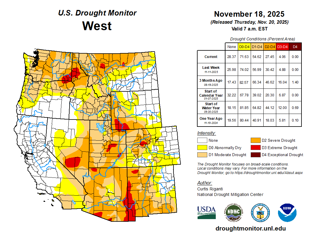


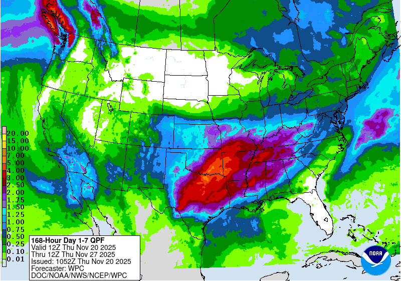
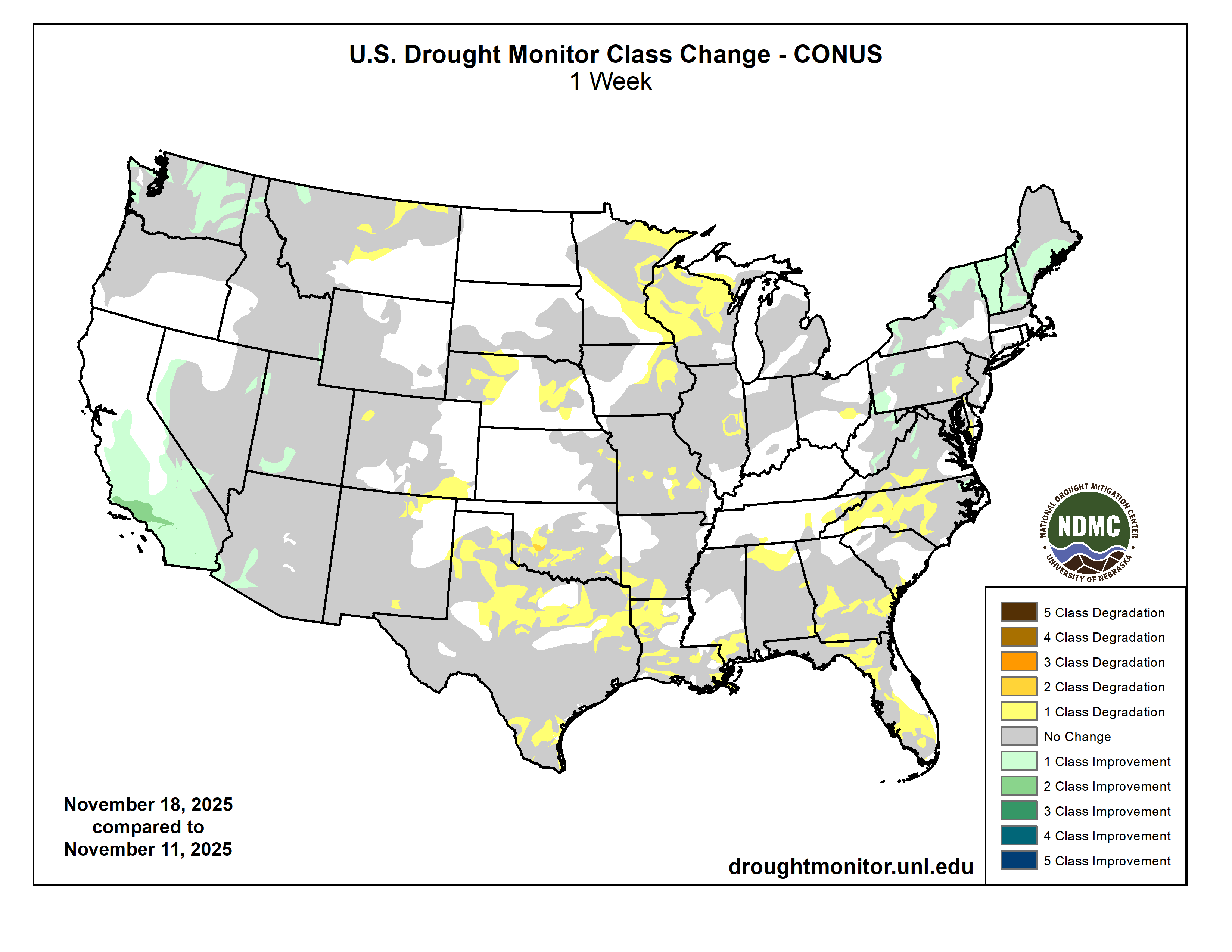
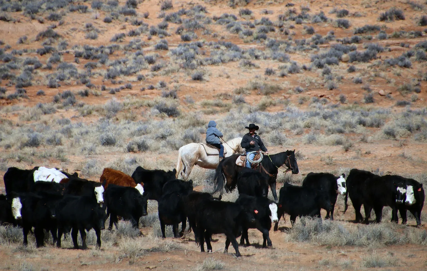
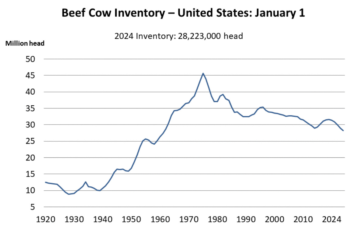
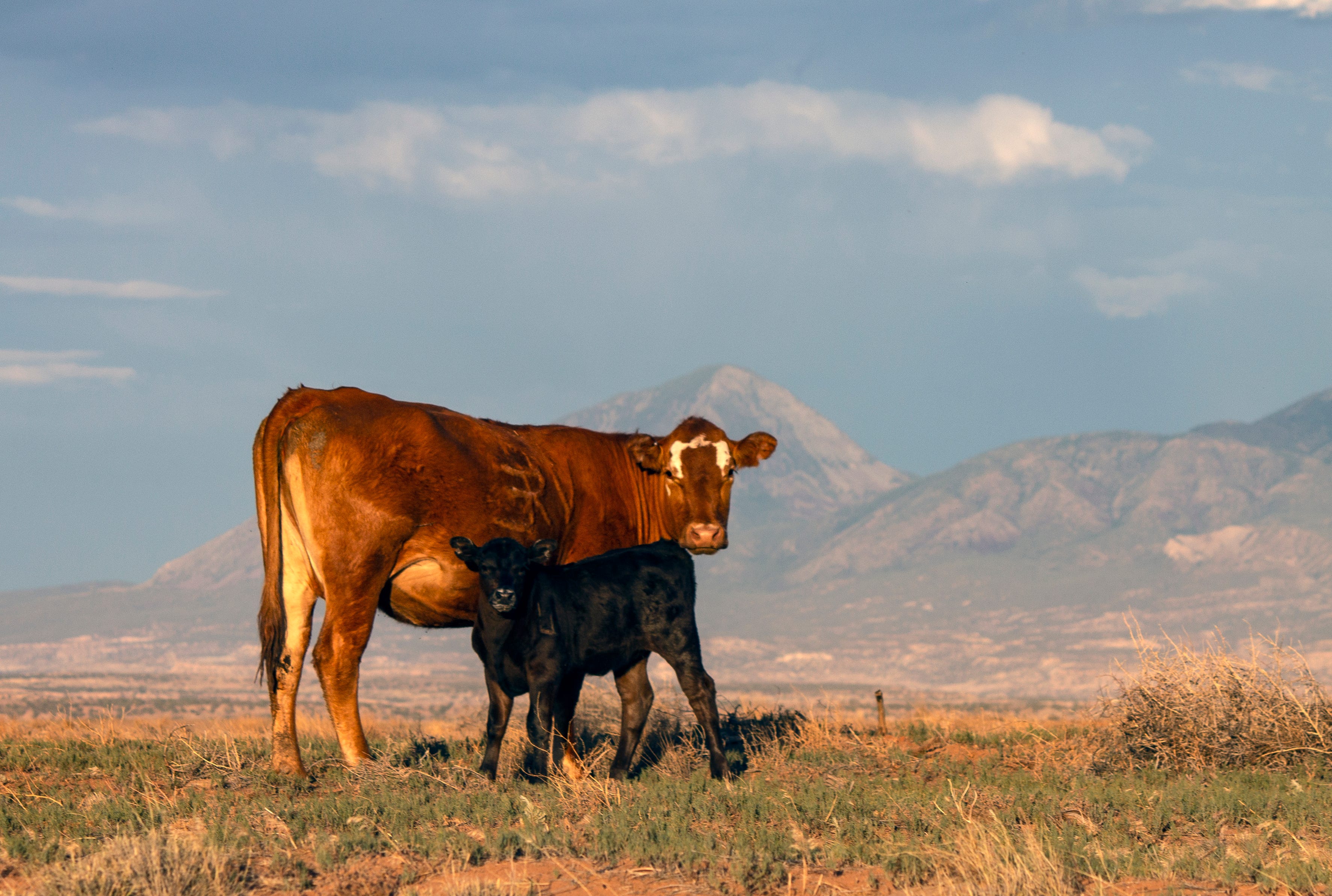
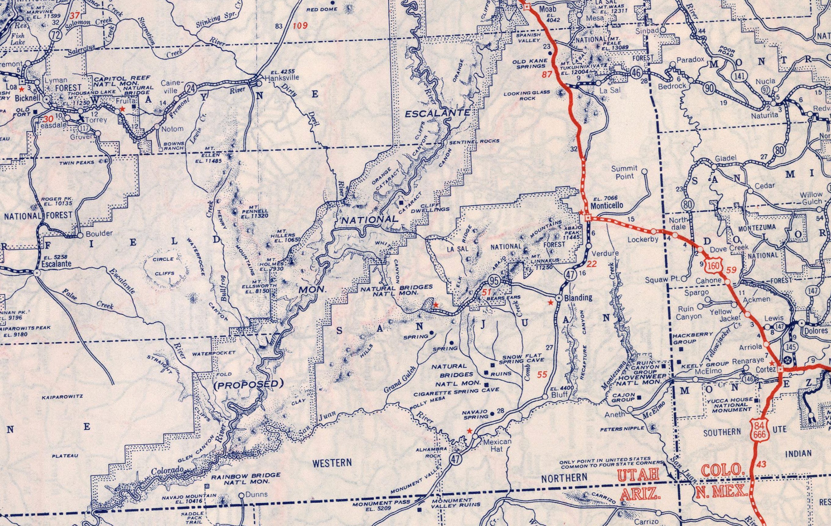
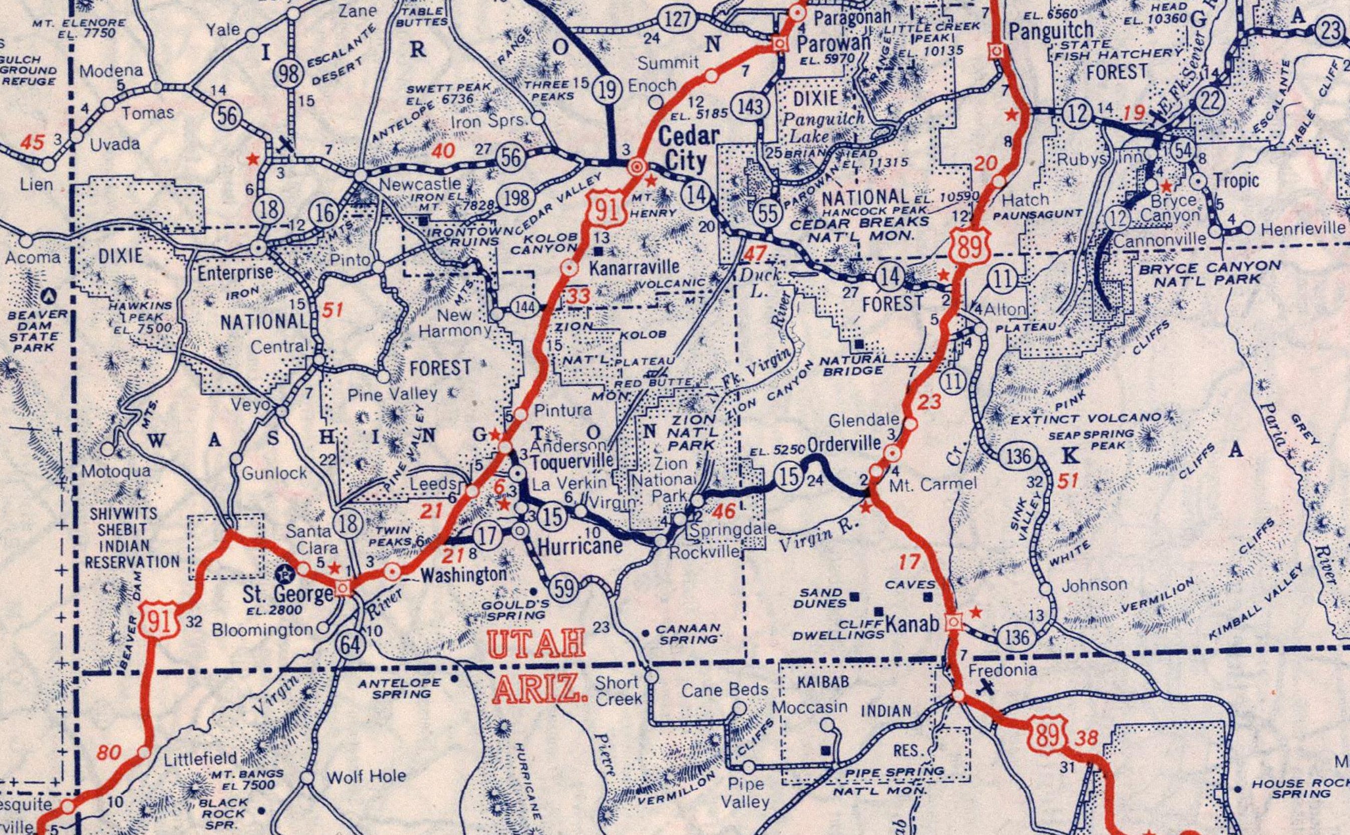

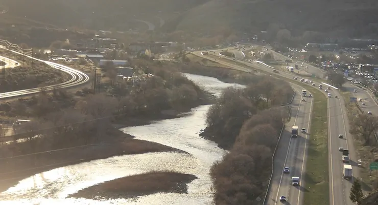

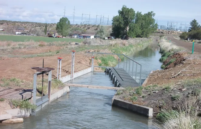


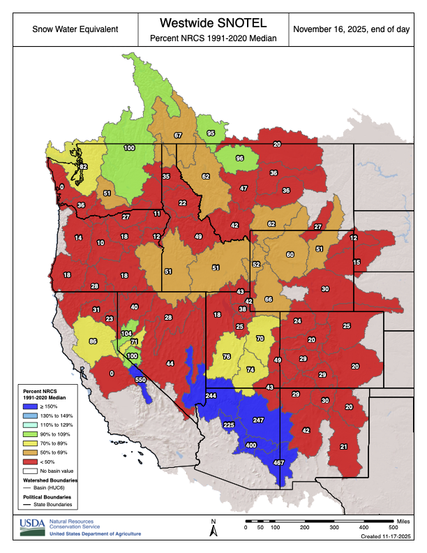

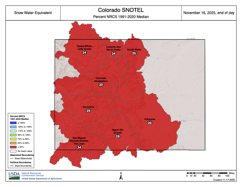


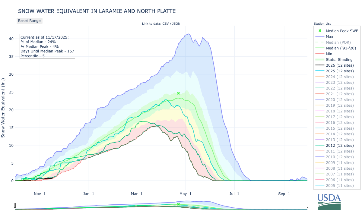
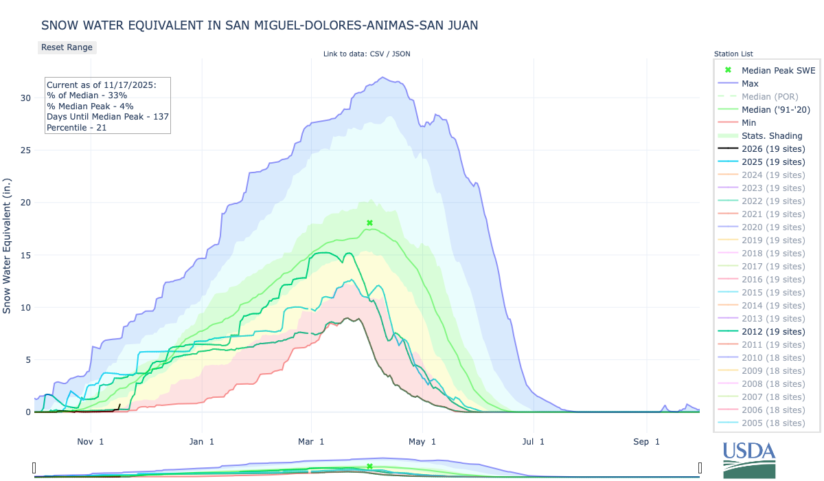


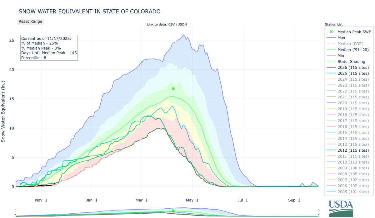
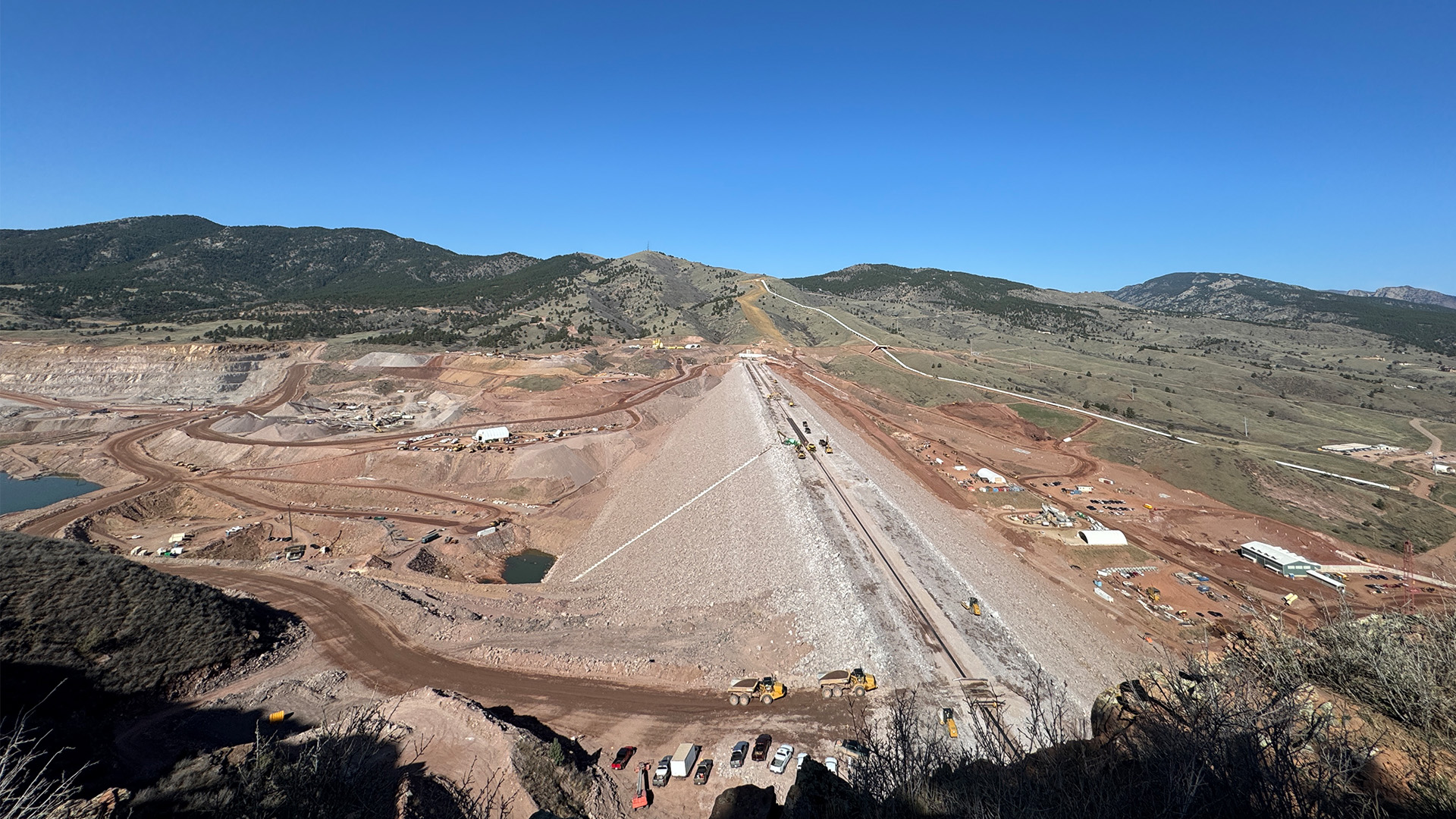

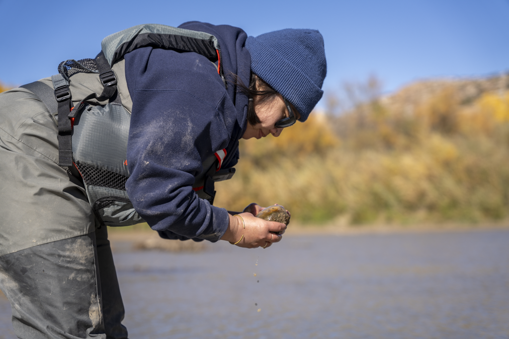


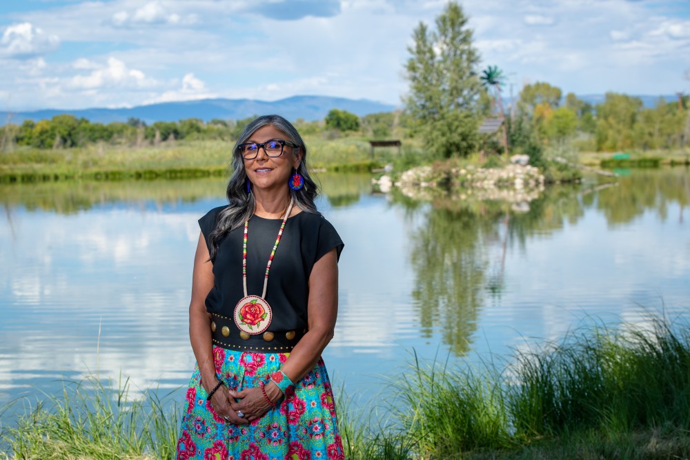

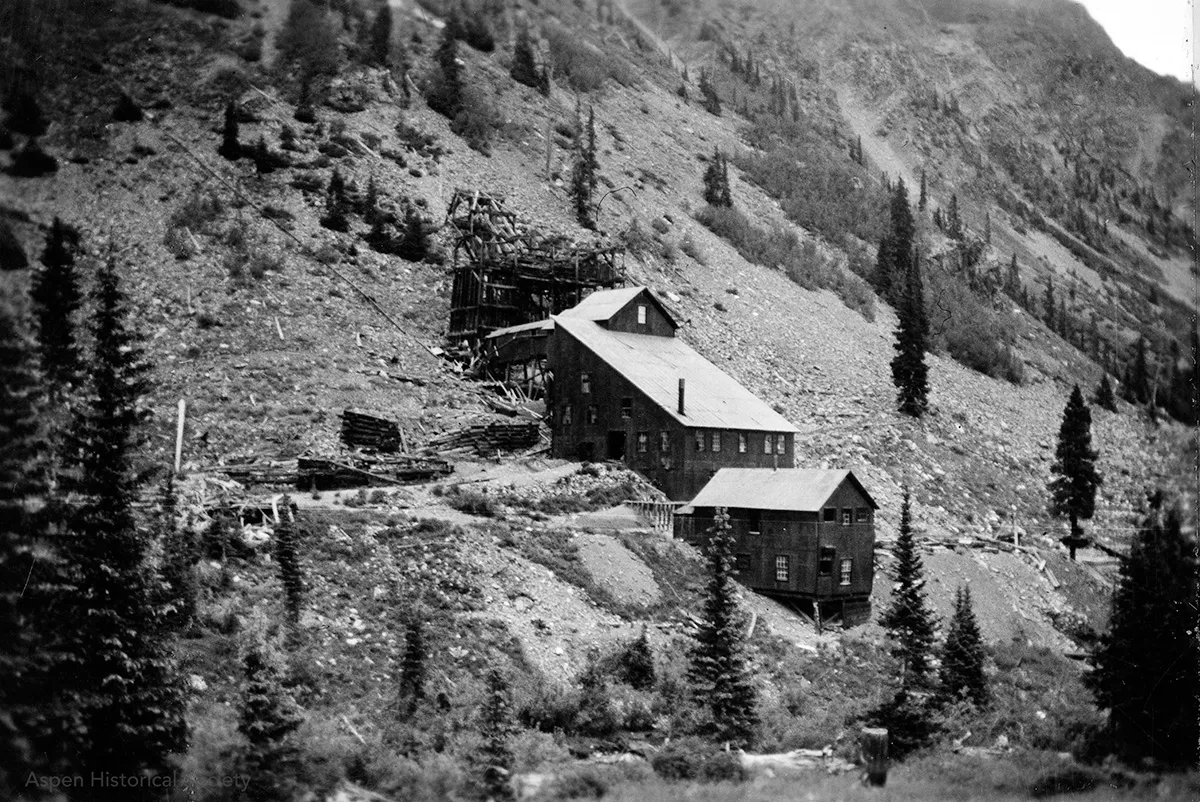
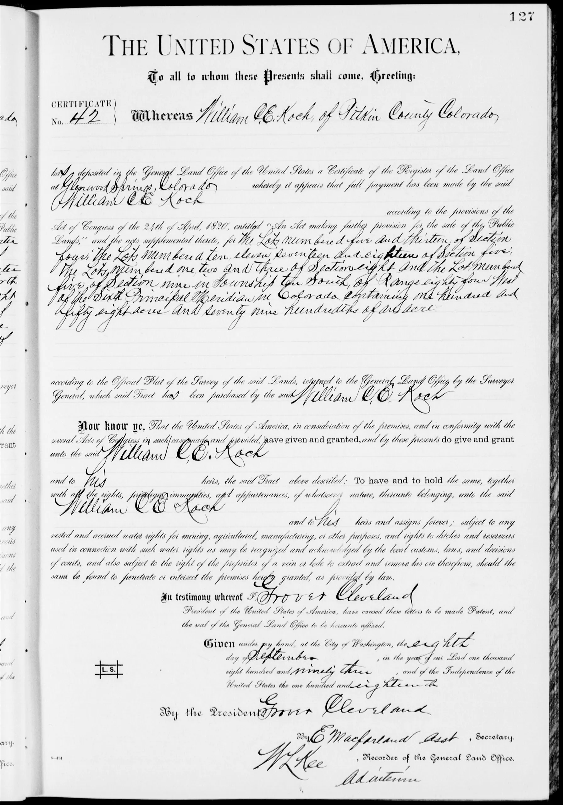
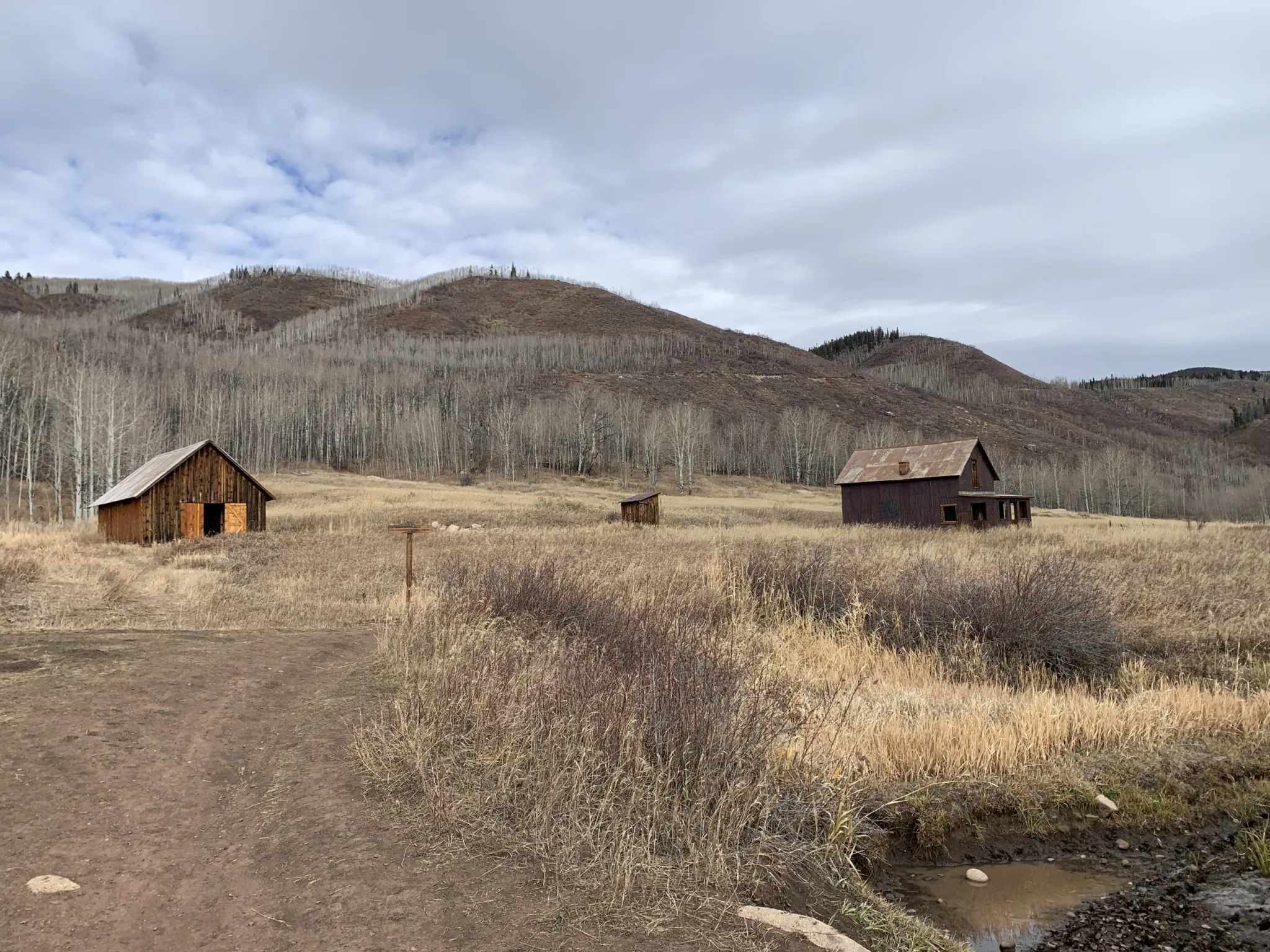


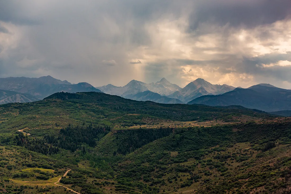
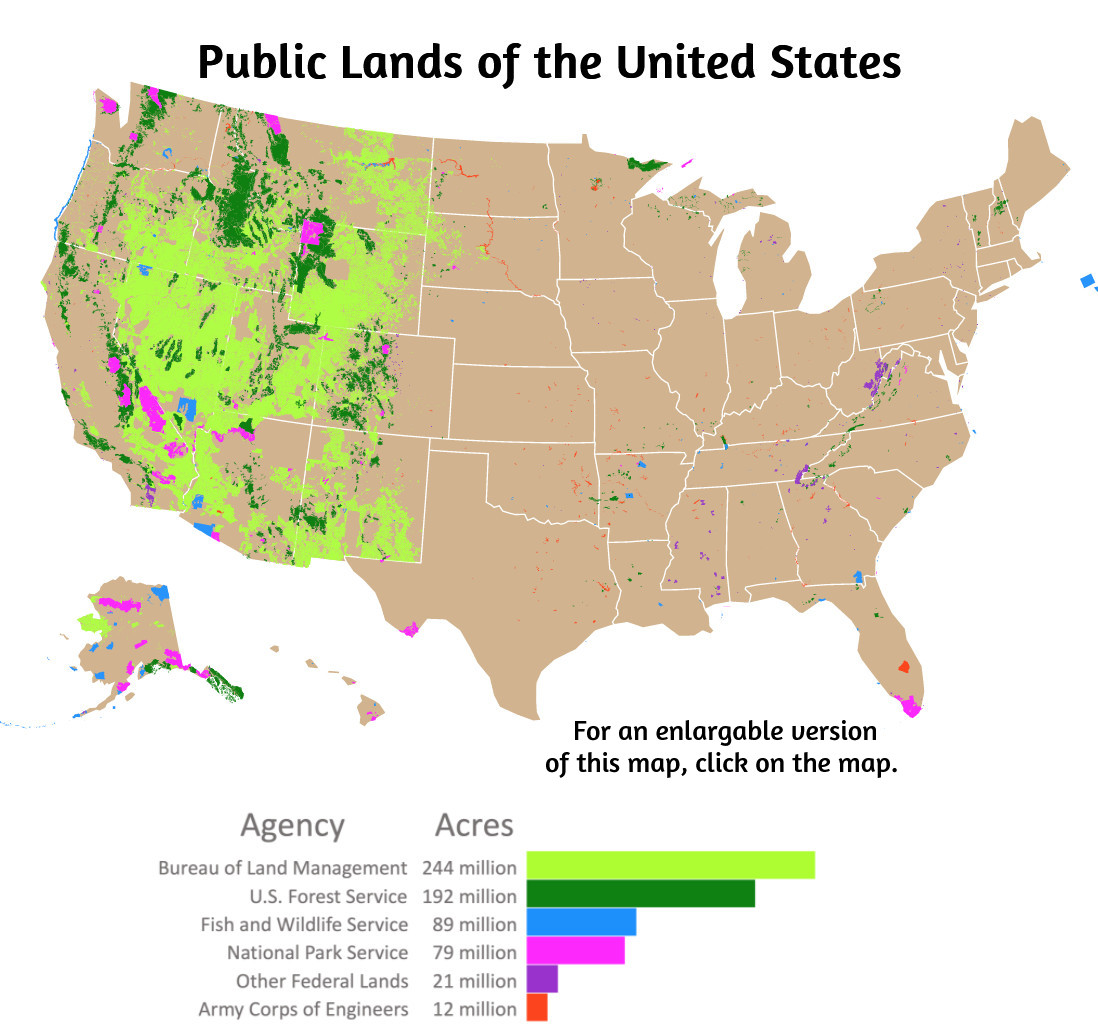
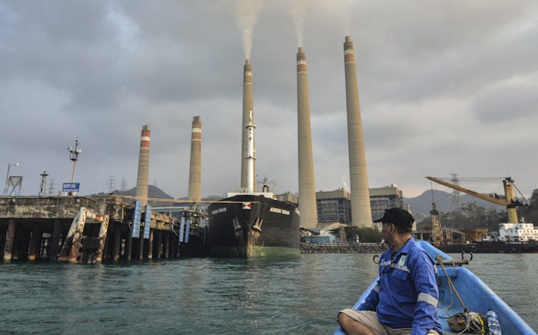


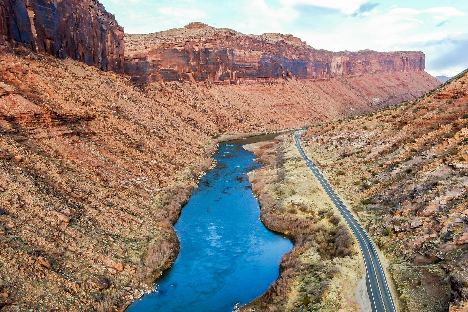

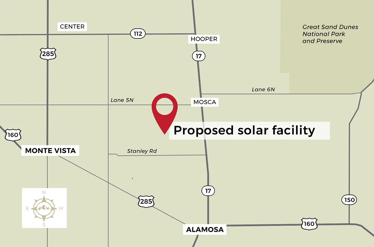


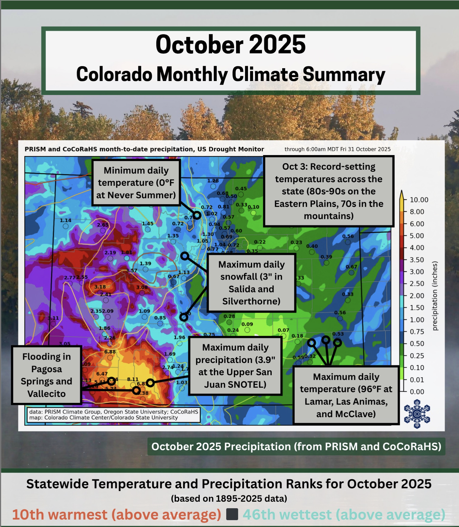

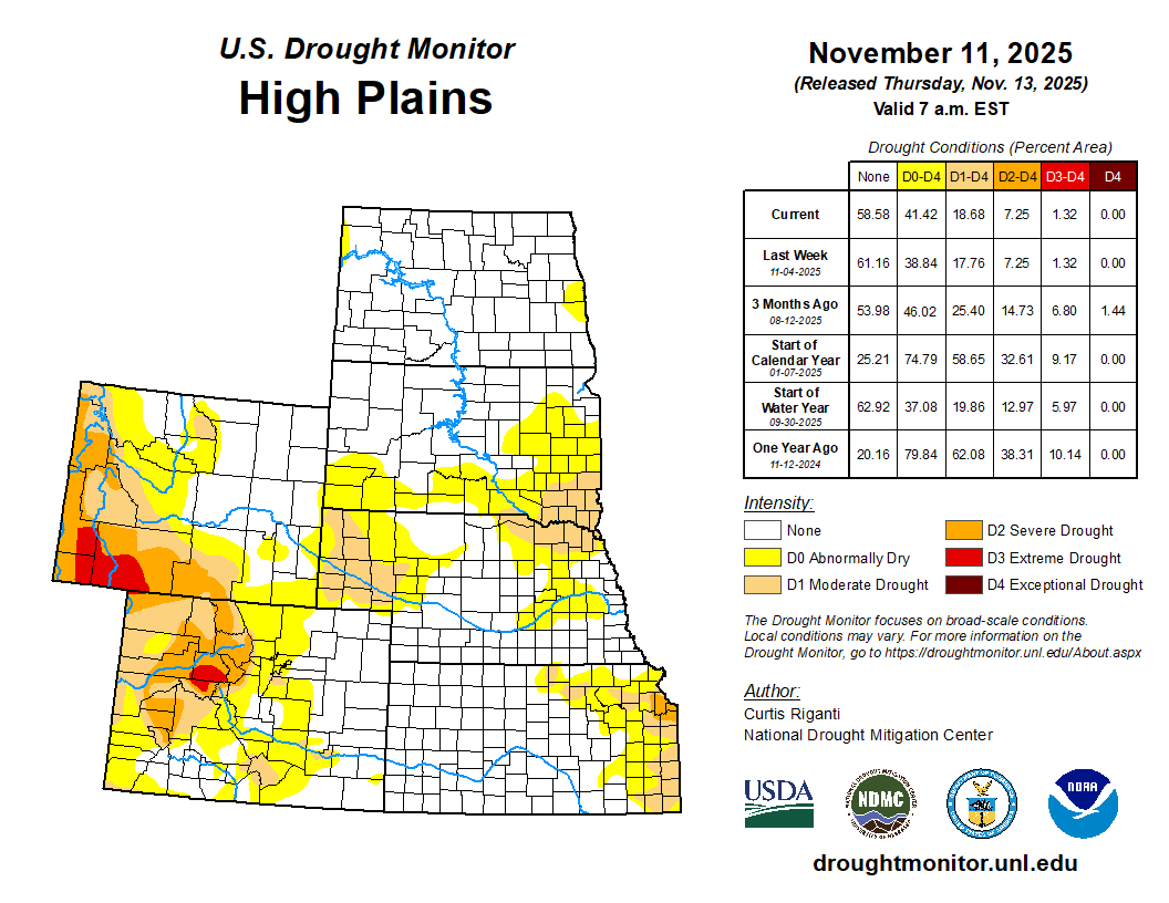
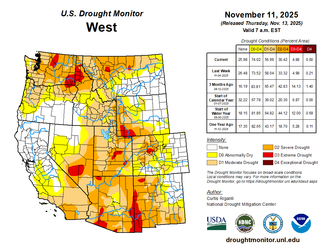
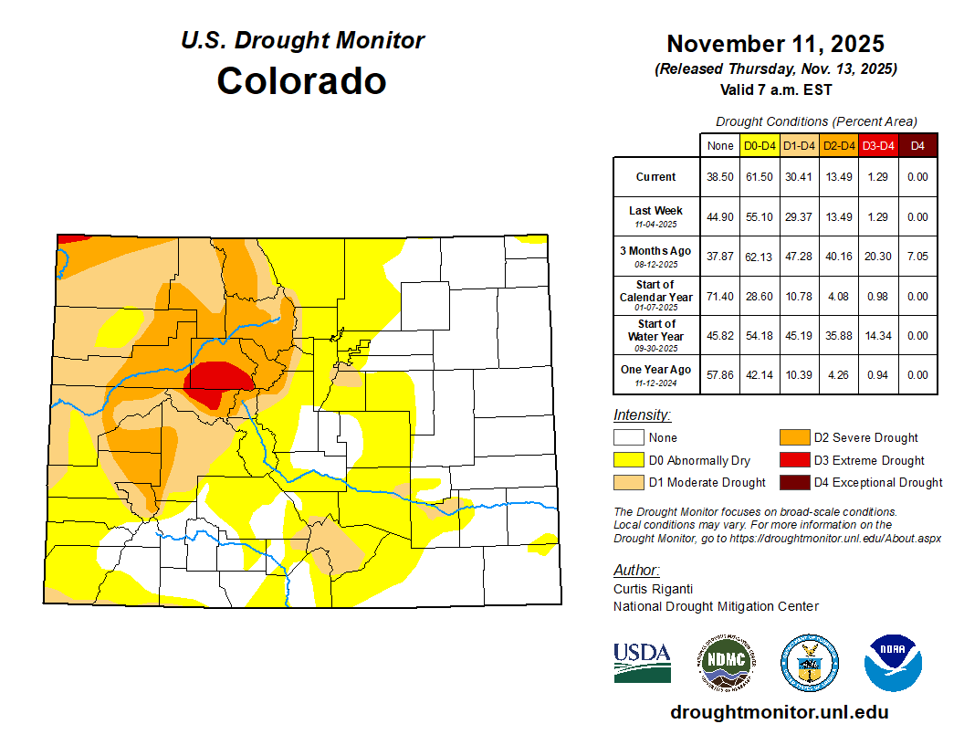
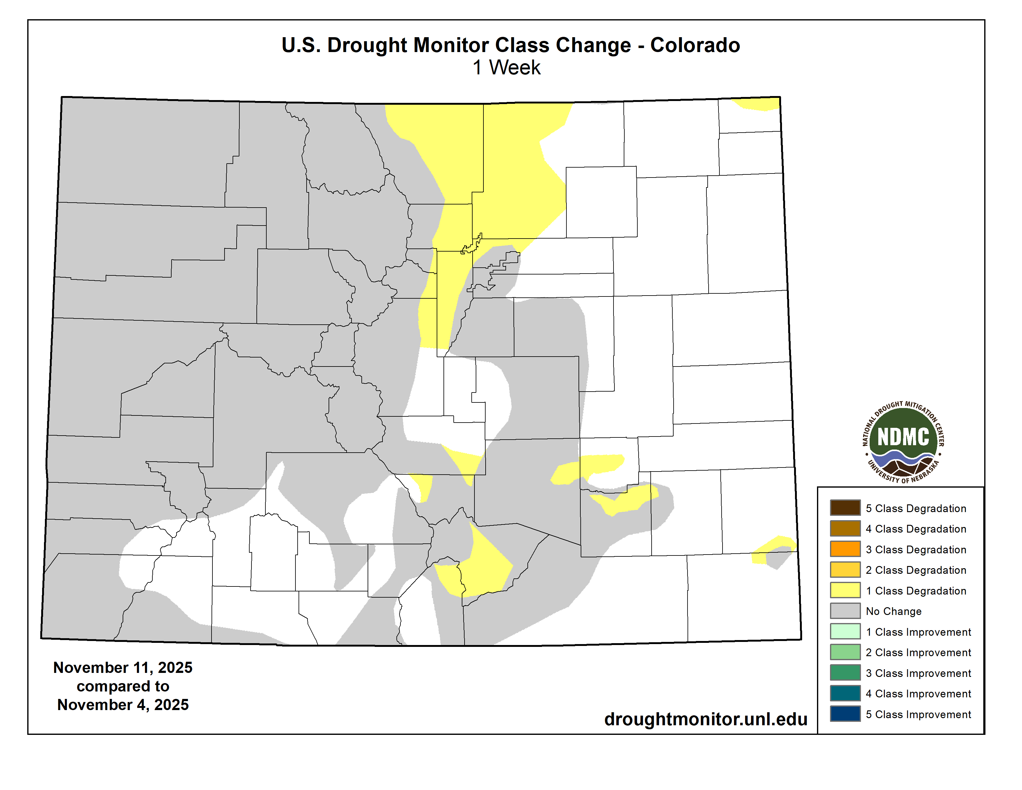


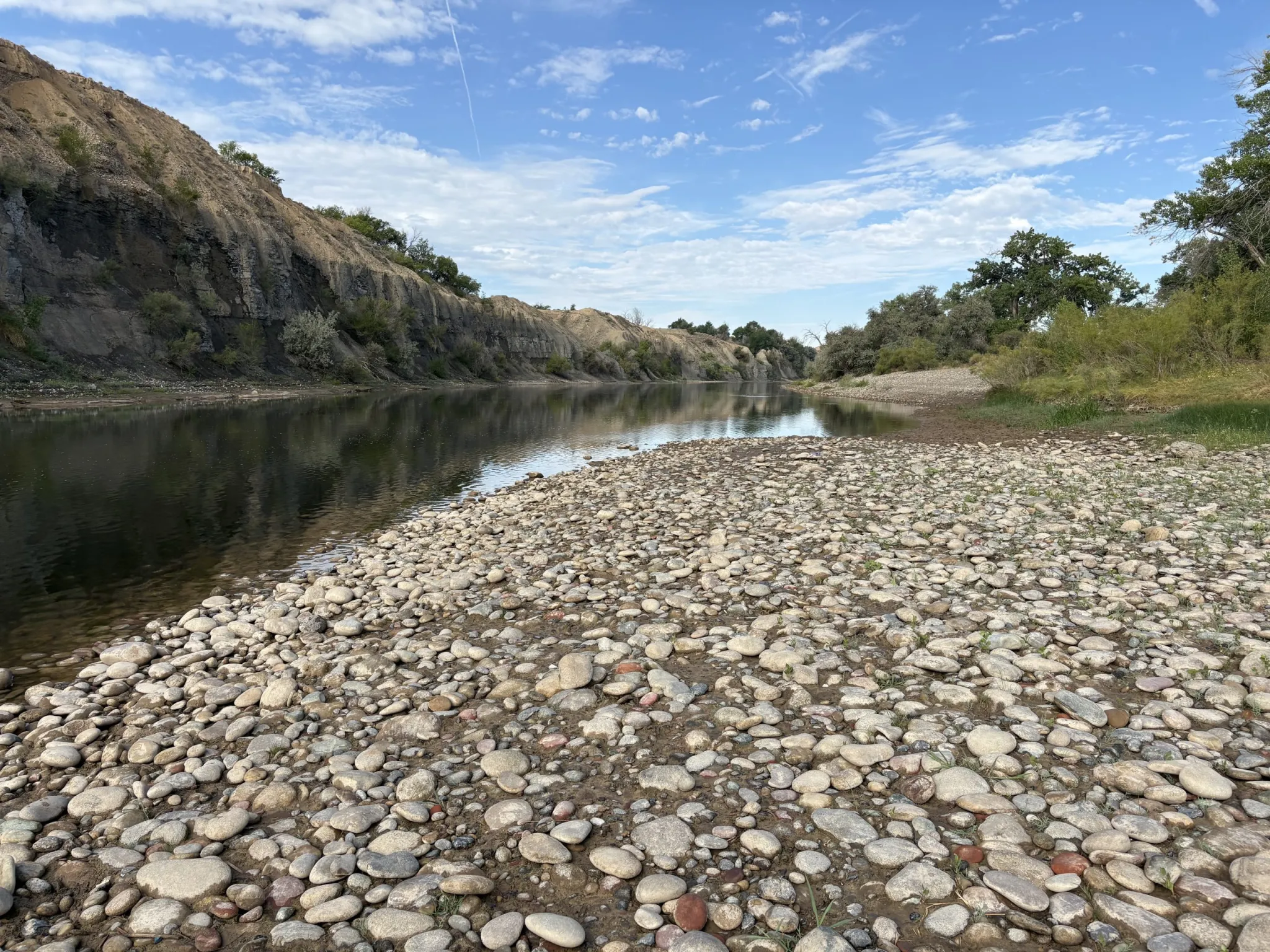

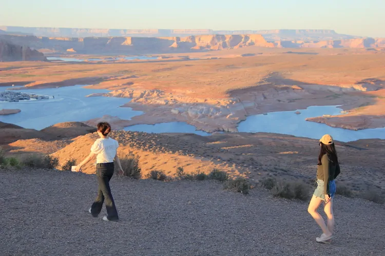
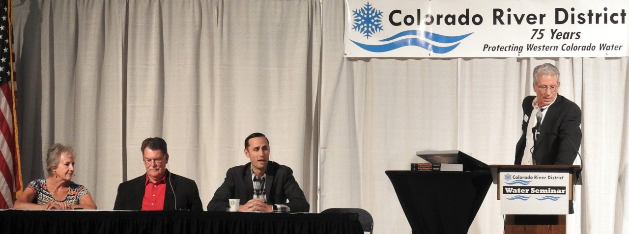


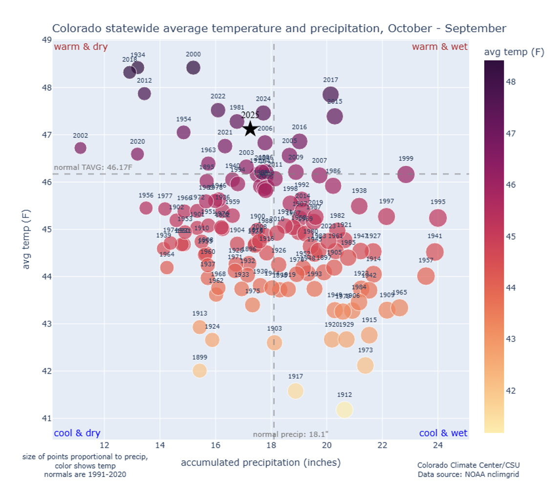
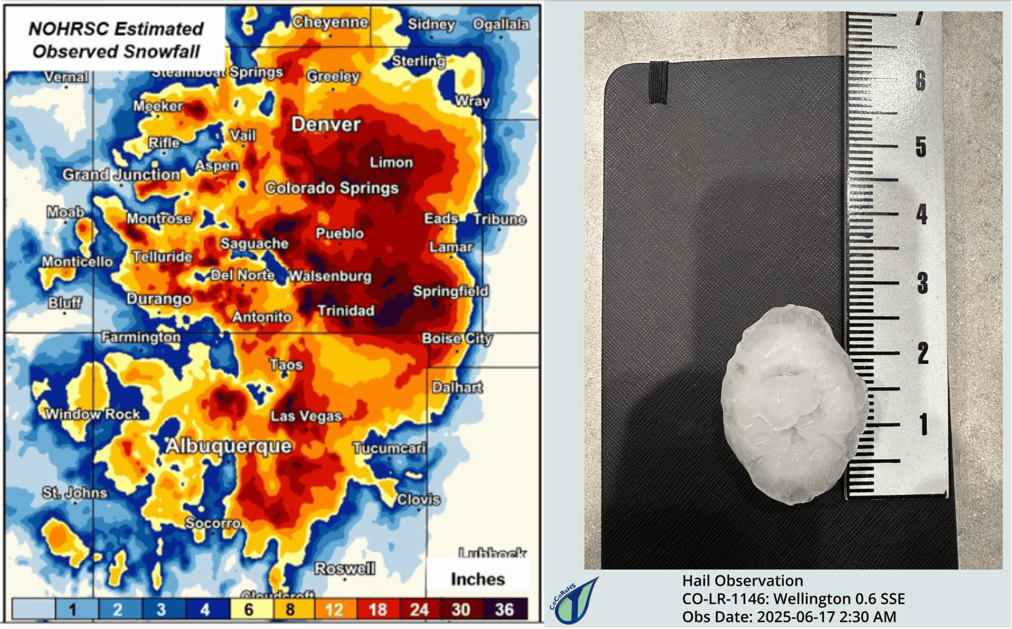

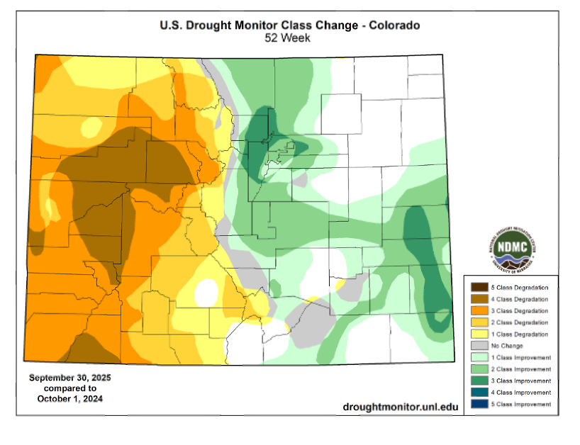

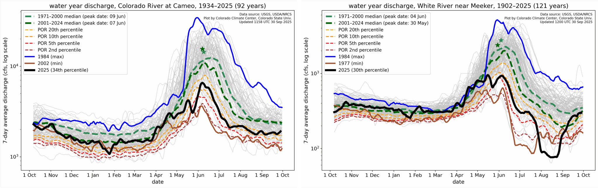


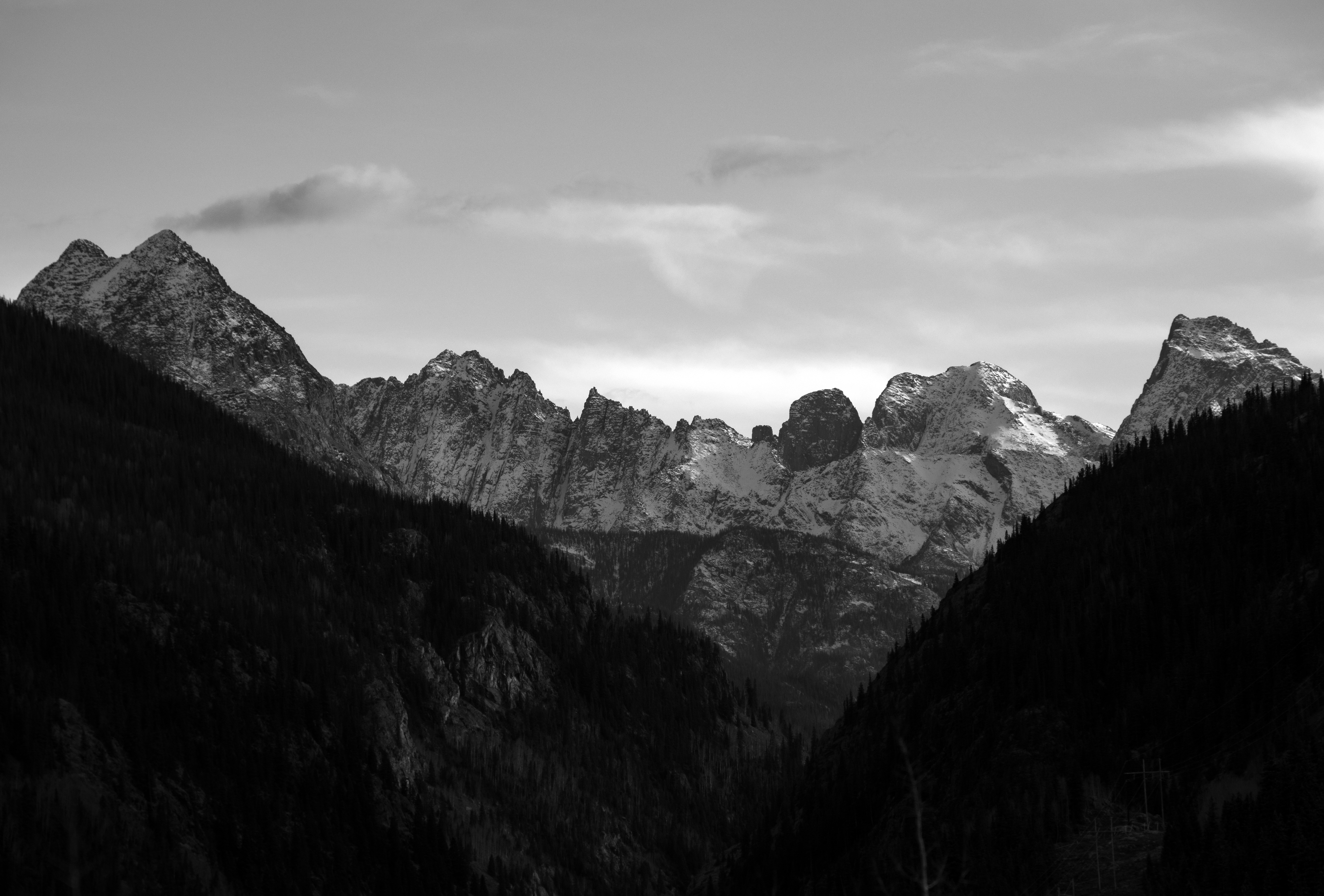


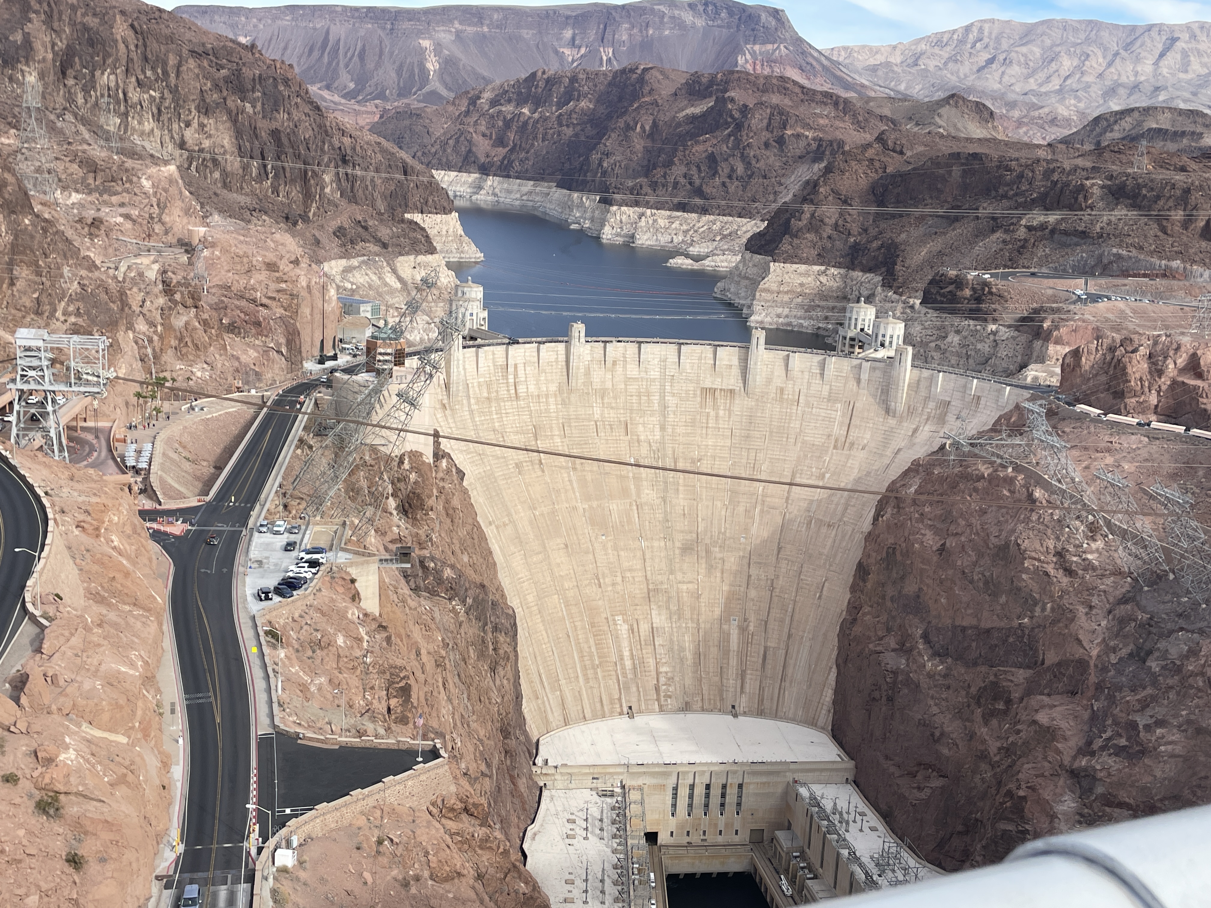


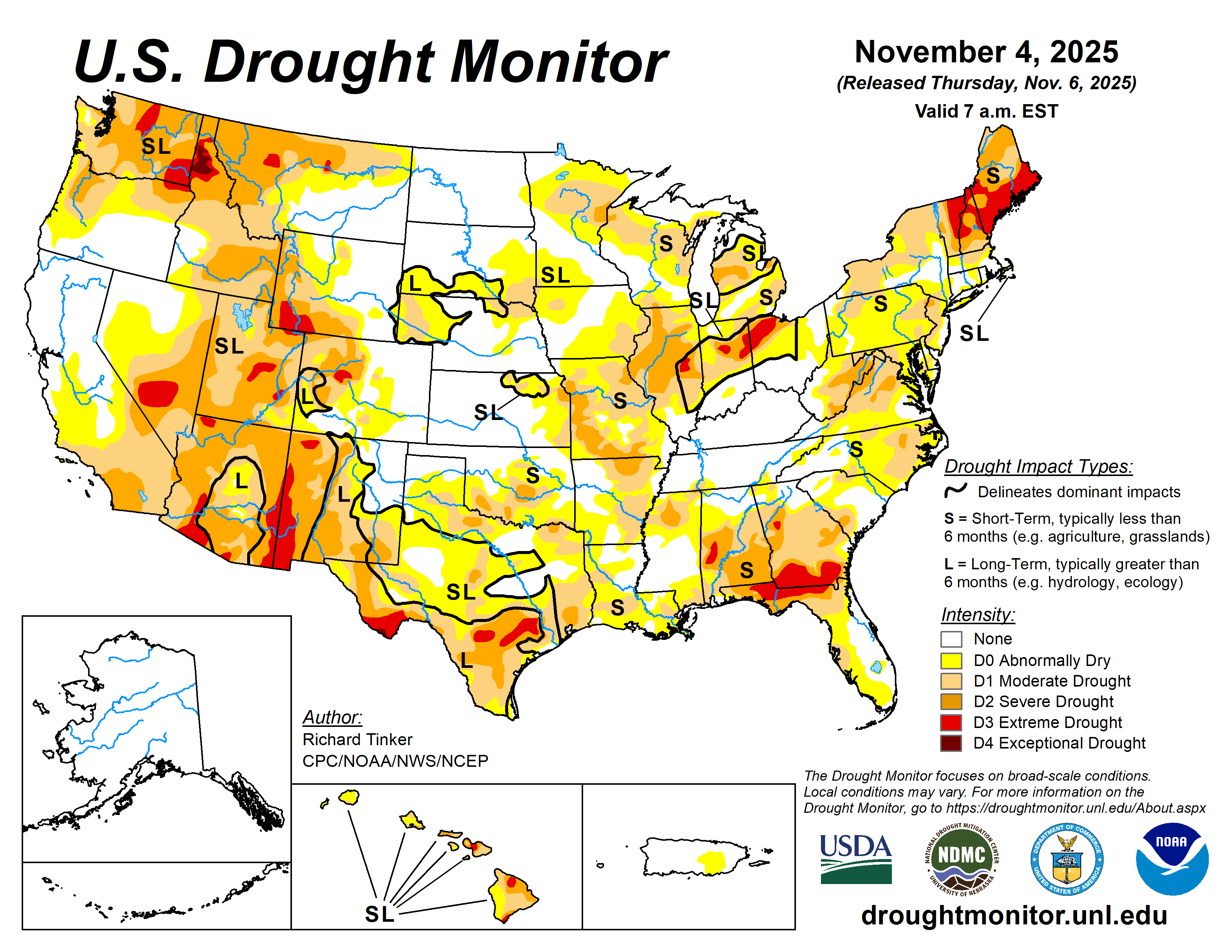


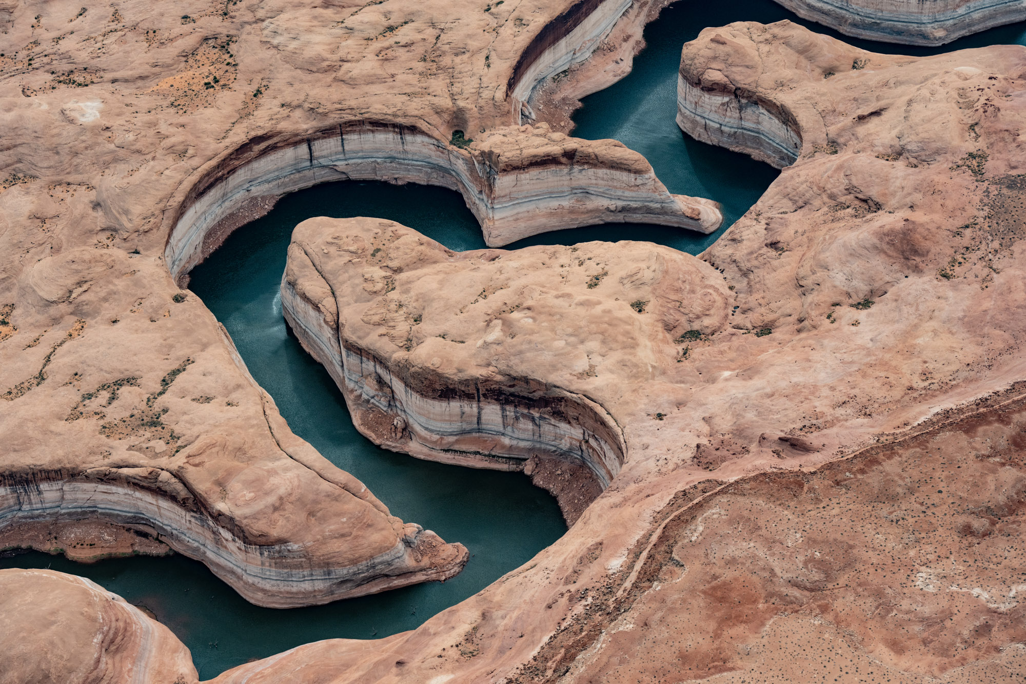


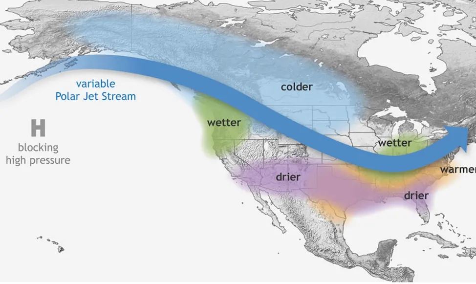
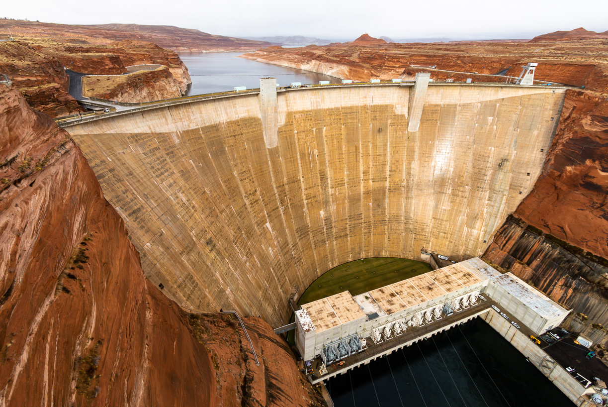


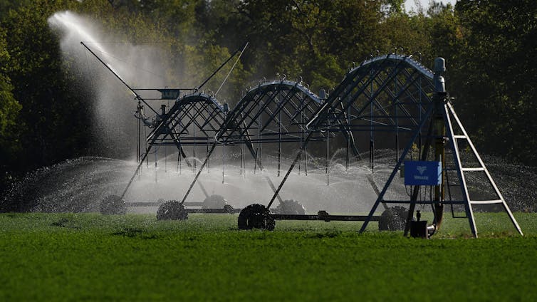
