Click the link to read the article on the Alamosa Citizen website (Evan Arvizu):
November 27, 2025
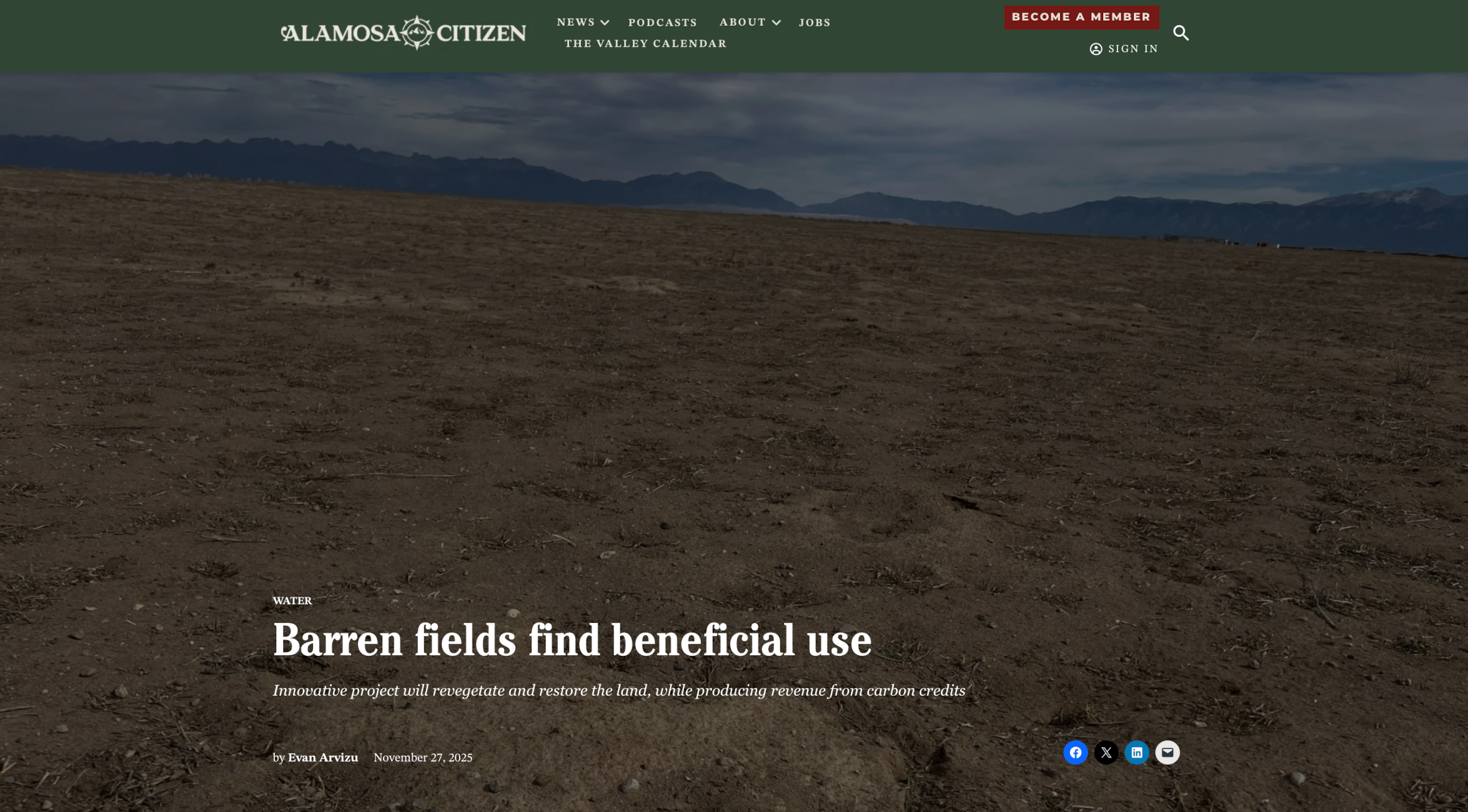
Down the Stanley Road looking north in central Alamosa County are the massive solar panels that offer an unusual but common skyline in the high mountain desert west of Mosca. In the foreground of the solar structures, on 480 acres of degenerated land, is a grand new experiment by the Colorado Land Board that promises to offer new insights into carbon, the Valley’s soil, and the growing but complicated “carbon market.”
In September the state land board inked a partnership with Land & Carbon Inc., a carbon project development company, to revegetate and restore the land under an initial 15-year partnership, and then a 40-year monitoring period to determine long-term success.
This is the first contract of its kind in the Valley, but it definitely won’t be the last. With more land and water being retired from irrigation every year, the question of how to revegetate only becomes more urgent. Revegation helps not just to improve carbon sequestration, but also to prevent dangerous dust-bowl conditions that threaten an increasingly dry Valley. The water on the Stanley Road property was retired to the Rio Grande Water Conservation District in 2024, and the partnership has committed to using only the allotted 18 inches of water over the first 3 years for revegetation. This project will illuminate the possibilities for revegetation in the Valley, and is likely to lead the way for more innovative partnerships and projects focused on both land restoration and carbon sequestration in the coming years.
The Colorado State Land Board manages lands that were granted to the state in a public trust from the federal government back in 1876. It operates as the second-largest land owner in the state, holding 2.8 million acres of surface land and 4 million acres of subsurface assets. Its land management practices aim to both steward the land and produce reasonable and consistent income, a majority of which gets distributed to the Colorado Department of Education’s Building Excellent Schools Today (BEST) program.
The Land Board established an ecosystem services program, focused on generating revenue from nontraditional products, like wetland and carbon credits, as opposed to more traditional products like agriculture, grazing, mining, oil and gas, hunting, recreation and renewables. A few years ago, through this program, the Land Board started exploring the prospect of carbon sequestration and carbon credits.
“We hired a group of consultants to help us enter this market. It’s new and not well understood by most people. It’s kind of on the leading edge of being developed, what we sometimes call an emerging market,” said Mindy Gottsegen, the State Land Board’s Stewardship and Ecosystem Services manager.
The carbon market has emerged as a viable way to simultaneously restore damaged lands, while generating valuable revenue. While there are government regulations around carbon emissions and compliance with certain environmental standards, the carbon market is an entirely voluntary system that operates without large government oversight. Companies buying and selling carbon credits can join the market, and participate, as long as they meet certain standards, set by third-party organizations.
While it is a complicated system, this is generally how it works for soil carbon credits in the Valley: Every piece of land has some amount of carbon in the soil because plants take in CO2 from the atmosphere, photosynthesize, and store it. Through plant roots, and the decay of other organic matter, the soil ends up holding on to a certain amount of carbon. Different land management practices can increase or decrease the amount of carbon sequestered.
To quantify carbon sequestration and sell credits, verified companies (or land owners) must first establish a baseline carbon measurement. Then, carbon gains are estimated over time using a combination of measurements and modeling. These numbers are reviewed, and based on the additional amount of carbon stored, carbon registries issue a proportionate amount of carbon credits. These credits can be sold on the market to entities looking to offset their carbon emissions. The revenue from carbon credits helps to fund and sustain carbon sequestration and land restoration projects.
“The Biological Carbon Program framework that our board approved in April of this year was kind of saying ‘This is how we’re going to get involved in the carbon market,’” said Gottsegen.
The program allows agricultural and land lessees to partner with board-approved Qualified Project Developers (QPDs) to create and implement restorative project plans. These companies work as the middle man between land owners and the carbon market, helping to make successful and sustainable changes, while also navigating the approval and acquisition of carbon credits.
Enter Land & Carbon Inc. Founded by Dave Lawrence in 2023, Land & Carbon is an innovative project development company, restoring highly degraded lands with low-cost, science-driven solutions. The company works to regenerate and revegetate land while offsetting and storing CO2 in the soil, using carbon credits to help pay for the projects.
“I used to — well I still do — drive around the country quite a bit. I’ve observed just how much degraded and barren land there is, without healthy crops or native vegetation — brown trampled land all around the country,” said Lawrence.
Lawrence had previously served as both the chairman of the Yale Climate & Energy Institute and the executive director of the Salk Institute Harnessing Plants Initiative. In these roles, he was actively involved in carbon projects, and realized that reducing atmospheric carbon would require more than just emissions reduction.
“I recognized that there were a number of different solutions available, and that they could be used in combination,” said Lawrence. “I started Land & Carbon with this idea that we would use a combination of practices, and collaborate with communities, ranchers, farmers, land holders, and experts — local, regional, national, and global — pulling all of this together to do the best job that we could restoring degraded land, and at the same time taking carbon out of the atmosphere.”
A significant amount of the degraded land across the West is largely agricultural and sits with different state land boards. Land & Carbon reached out to the Colorado State Land Board with hopes of collaborating to regenerate these lands in a way that was mutually successful, taking advantage of best practices to sequester carbon, restore ecosystem health, and help fund the state’s public education system.
Land & Carbon got approved as the Land Board’s fourth QPD in August and the deal, officially titled Grassland Carbon Ecosystem Services Production Lease, ES 117611, came soon after.
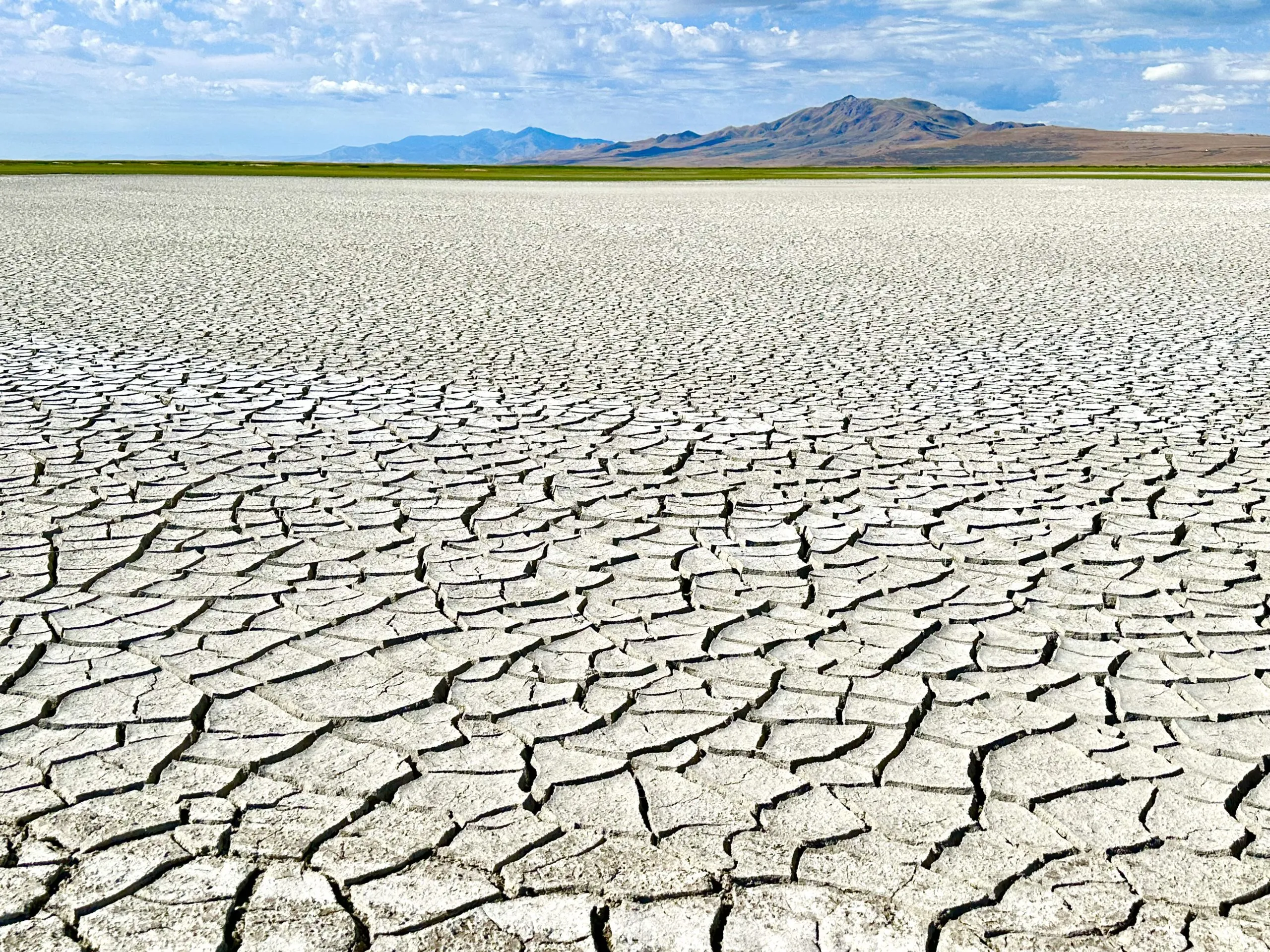
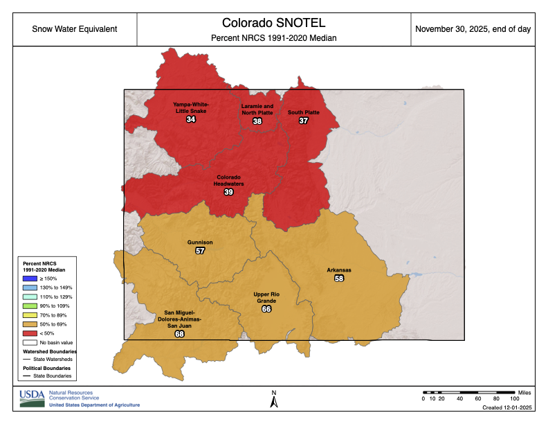
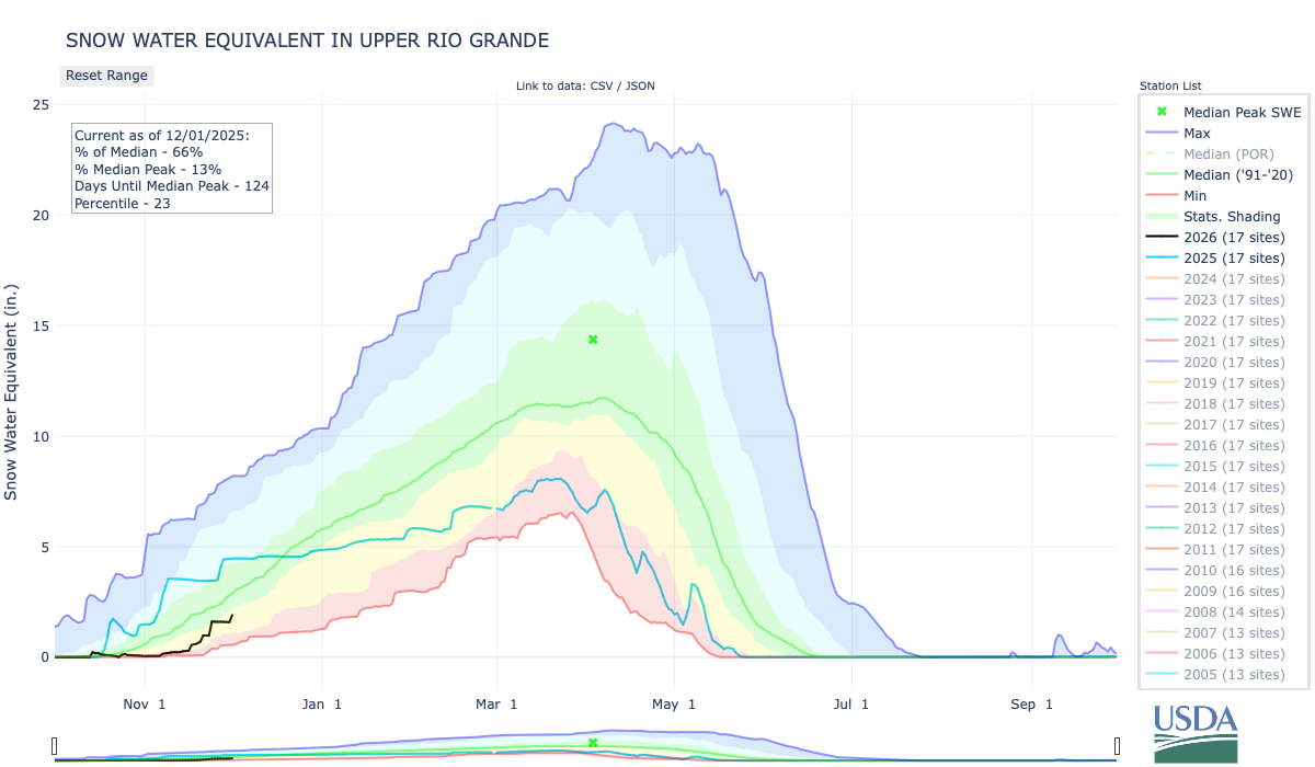
Of the land in the State Land Board’s portfolio, the Stanley Road property was selected because of a combination of factors. The property consists of 480 acres, in between Stanley Road, the 105, and the 106. It sits within Subdistrict 1, and its water rights, all groundwater access and wells, were sold to the Rio Grande Water Conservation District in December of 2024. This means moving forward there are severe limitations to the amount of water that can be used to revegetate. The land is highly degraded from decades of agricultural use, and has been barren for years. In that time, a takeover of invasive weeds, along with harsh soil and climate conditions, have prevented any sort of natural recovery.
This property had been a challenge for the Land Board, because of the amount of damage. While this level of degradation can be seen as a deterrent for other QPDs, these types of highly degraded properties are exactly what Land & Carbon seek out. When the Land Board asked if it would be interested in taking on the challenge, the answer was a resounding “Yes.”
In any project for Land & Carbon, the first steps include a “scope and discovery” research deep dive, to better understand what has already been done, and learn how its efforts will be situated in the broader context of work in the region. In the Valley, this means looking at CSU Extension information, published papers, USDA, State Land Board and Conservation District data, conducting their own boots-on-the-ground field visits, and also engaging with the community. All of it is pulled together to assess initial land characteristics.
“We’re a big believer in talking with people and learning from people who are actually doing the work. So we participated in workshops, convened by Colorado State, that allowed us to get to know different individuals and people and groups who were already doing things,” said Lawrence. “We don’t believe we have the corner on the market on all expertise. We really try to tap into as much local knowledge as we can, as to what has worked, what hasn’t worked and why.”
After that, an exhaustive evaluation of all available data and information is done, pulling in literature, field data, and models to create an initial plan, taking into consideration resource availability and supplies. Then they take baseline measurements to determine the starting amount of carbon in the soil that is crucial to then quantify improvements and carbon credits.
The Stanley Road project is still in these early stages, and they are working to collect data, determine land characteristics, and establish a carbon baseline, before considering different solutions and strategies.
“We tailor our solutions to the land. Not everything grows everywhere and not all grazing practices work everywhere. So how can we tailor the best combination to this land?” said Lawrence.
The next steps will come in the spring, at the start of the growing season, when Land & Carbon plans to establish what it has trademarked as Innovation Sites. These five- to 20-acre patches on the property are used to test out new ideas and different combinations, seed mixes, and technologies, in order to learn what works best on this specific land. These experimental sites will run for three to five years, after which the best, most successful techniques will be used on the larger property. Many of the tests will not work, but some will, and those are what get implemented broadly.
In the years to come, these plans will continue to develop. Final decisions around irrigation, and how to use the 18 inches of water allocated for the first 3 years of the project, have not yet been made. Nor have more definitive restoration plans, though in the press release by the Land Board, it was stated that the property is expected to support regenerative grazing within four to eight years.
The project is estimated to sequester greater than 10,000 metric tonnes of CO2 in the first 15 years, which is when the initial contract ends. This will be followed by a 40-year monitoring period to ensure the permanence of the soil carbon storage.
With the state of water in the Valley, and efforts to retire agricultural land for water conservation purposes, the amount of land in need of revegetation and restoration will only continue to grow over the next few years.
Both the State Land Board and Land & Carbon expressed interest in expanding the reach of this project and methodology, once it has been established. But that will take time.
“I always think it’s good to try to do one thing very well, and to kind of get a proof point. We are very focused on this property, and of course we would love to work with others as we move along in this, and show what we have going,” said Lawrence.
“We’re just getting started. The first few take extra time, but we’re hoping that once we get these few under our belt, we’ll be able to expand,” said Gottsegen. “Hopefully we can continue to build the carbon program with more leases in the coming years.”
Lawrence emphasized that Land & Carbon aims to make this project the template for affordable, quality land regeneration using carbon credits, that will work for people in the Valley.
“The idea is that what we learn, we share. We can serve as just advisors if that’s what somebody who has all the capabilities wants, and there’s a ton of people with capabilities, or we can actually do the work,” said Lawrence. “I think we all know the challenges that we face with water in the San Luis Valley. It’s important that we take whatever we learn, in collaboration with others, and work with them to try to implement this at scale.”
Evan Arvizu
Evan Arvizu is a recent graduate of Colorado College with a degree in Environmental Anthropology and minor in Journalism. She is a former intern with the Rural Journalism Institute of the San Luis Valley. More by Evan Arvizu