
I’m in Las Vegas for the 2025 Colorado River Water Users Association annual conference! Follow along on the CRWUA Twitter (X) feed: https://x.com/CRWUA_water. Take a look back at our LinkedIn, blog, and Instagram posts from this year.

I’m in Las Vegas for the 2025 Colorado River Water Users Association annual conference! Follow along on the CRWUA Twitter (X) feed: https://x.com/CRWUA_water. Take a look back at our LinkedIn, blog, and Instagram posts from this year.

December 15, 2025
The effort to permanently protect the historic Shoshone water rights gained additional momentum as two more west slope communities committed funding in their 2026 budgets toward the Colorado River District’s $99 million purchase agreement with Xcel Energy. The Town of Breckenridge has pledged $100,000, and the Town of Gypsum has committed $15,000, underscoring the importance of reliable Colorado River flows for communities from the headwaters to the state line and beyond.
By committing financial support for the Shoshone Water Rights Preservation Project, Breckenridge and Gypsum join a large and growing coalition of Western Slope partners working to safeguard flows that support local economies, healthy rivers, and long-term water security for Colorado.

“The Shoshone water rights are a cornerstone of the Colorado River system and a critical part of protecting our quality of life in the high country,” said Breckenridge Mayor Kelly Owens. “Breckenridge is proud to stand with partners across the West Slope and headwaters region to keep water in the river, support our outdoor recreation economy, and protect this vital resource for generations to come.”

“Look, in Gypsum we see it every single day, our local ranches, our jobs, our families all depend on the Eagle and the Colorado running strong and flowing,” said Gypsum Mayor Steve Carver. “Backing Shoshone just makes sense. It gives us some certainty when water gets tight. We’re happy to jump in with everybody else and keep that water right here on the Western Slope.”
The Shoshone Water Rights Preservation Coalition, led by the Colorado River District, now includes 35 local governments, water entities, and regional partners across the Western Slope, as well as support from across the state. Together, these partners have committed over $37.3 million toward the $99 million purchase price, in addition to state and federal investments to protect a critical piece of Colorado’s water security.
“Communities across the West Slope continue to step up together in a powerful way,” said Andy Mueller, general manager of the Colorado River District. “Support from Breckenridge and Gypsum reflects a shared understanding that Shoshone is about more than one community or region. It’s about working together to keep the Colorado River and its tributaries flowing for the environment, agriculture, recreation and local communities across Colorado that rely on this water.”

The Shoshone hydroelectric plant, located in Glenwood Canyon, holds nonconsumptive senior water rights that date back to 1902. These rights are essential for supporting flows in the Colorado River, benefiting agriculture, recreation, rural economies, and water users across the West Slope and beyond.
In December 2023, the Colorado River District entered a purchase and sale agreement with Xcel Energy to acquire and permanently protect the water rights, with plans to negotiate an instream flow agreement with the Colorado Water Conservation Board. This agreement would safeguard future flows, regardless of the Shoshone plant’s operational status.
In January 2025, the Bureau of Reclamation awarded $40 million in federal funding through a program authorized by the Inflation Reduction Act. The River District continues to work with the Bureau and remains optimistic that the project’s broad support and clear public benefit will secure the necessary federal funds to complete this once-in-a-generation investment.
Learn more about the Shoshone Water Rights Preservation Project & Coalition at KeepShoshoneFlowing.org.


Click the link to read the article on the AZCentral.com website (Brandon Loomis). Here’s an excerpt:
December 15, 2025
Key Points
- Seven states and 30 tribes that depend on the Colorado River are looking for ways to share a shrinking resource, but environmental groups fear little will be left for the river itself.
- A wetlands at the end of the river and a fishery at its midpoint show what can happen when water is managed to preserve nature’s needs.
- Growing demand on the river and competing interests, including electric power providers, could force negotiators for the states to confront difficult decisions.
CIÉNEGA DE SANTA CLARA, Mexico — The rusty observation tower at the edge of this wastewater-fed marsh offers an osprey-eye view of two possible futures for the parched and overworked Colorado River. To one side, the marsh spreads across more than 20 square miles of pools and islands choked with cattails and phragmites, convoys of pelicans descending and splashing down for a rest on their journey south from the Great Salt Lake or other western waters. Dragonflies hover below, while a fish hawk circles above, scanning the open water between the reeds. This is a vision of a future in which partners across the Western United States and Mexico save enough water that they can spare some for nature, even if it means irrigating it with the salty dregs. On the tower’s other side, boundless flats of sand and cracked mud spread to the horizon across what was, prior to the river’s damming a century ago, one of Earth’s great green estuaries.

Jennifer Pitt leaned against a rail atop the tower and scanned that dusty horizon. A century ago, she said, the river had meandered so widely and soaked so much verdant ground there that the naturalist Aldo Leopold had written in “A Sand County Almanac” that “the river was nowhere and everywhere,” unable to “decide which of a hundred green lagoons offered the most pleasant and least speedy path to the Gulf (of California).”
Now the Grand River’s delta supports just a handful of green lagoons, all fed either by wastewater or by targeted environmental irrigation. Pitt leads the Audubon Society’s Colorado River program. She has toiled for decades alongside American and Mexican conservationists to rebuild slivers of living delta from what’s left of the water after dams, farm ditches and growing cities divert most of the great river along its 1,450-mile route from the Rocky Mountains toward its dry mouth on the Sea of Cortez near here. A century ago, the river would have wandered a soaked delta teeming with birds, jaguars and legendary biodiversity. Now, a wastewater marsh must do the ecological heavy lifting.

“If we can’t prioritize taking care of a place like this, I fear for our ability to take care of ourselves,” Pitt said.

The next few months will be a turning point in efforts to preserve a measure of nature here and across the river’s length, as the seven U.S. states that split the bulk of the water struggle to reach a new deal among themselves that could also determine how much water is available to nurse a remnant of the river’s own environment. Federal officials have said Interior Secretary Doug Burgum is prepared to impose his own cuts if the states can’t reach their own deal, and have said they need a negotiated plan by late winter to avoid that outcome. More than two decades of “megadrought,” unprecedented in U.S. history, have left little wiggle room for year-to-year operations. Reservoirs that were near their 58.48 million-acre-foot capacity in 2000 began the 2026 water year on Oct. 1, with just 21.8 million acre-feet behind the dams. Each acre-foot contains about 326,000 gallons and is roughly enough to support three households for a year, though the bulk of the water flows to the region’s farms.

Shuang-Ye Wu, University of Dayton
The summer of 2025 brought unprecedented flash flooding across the U.S., with the central and eastern regions hit particularly hard. These storms claimed hundreds of lives across Texas, Kentucky and several other states and caused widespread destruction.
At the same time, every hurricane that formed, including the three powerful Category 5 storms, steered clear of the U.S. mainland.
Both scenarios were unusual – and they were largely directed by the polar jet stream.
Jet streams are narrow bands of high-speed winds in the upper troposphere, around four to eight miles (seven to 13 kilometers) above the surface of the Earth, flowing west to east around the entire planet. They form where strong temperature contrasts exist.
Each hemisphere hosts two primary jet streams:

The polar jet stream is typically found near 50 to 60 degrees latitude, across Canada in the Northern Hemisphere, where cold polar air meets warmer midlatitude air. It plays a major role in modulating weather systems in the midlatitudes, including the continental U.S. With winds up to 200 mph, it’s also the usual steering force that brings those bitter cold storms down from Canada.
The subtropical jet stream is typically closer to 30 degrees latitude, which in the Northern Hemisphere crosses Florida. It follows the boundary between tropical air masses and subtropical air masses. It’s generally the weaker and steadier of the two jet streams.

These jet streams act like atmospheric conveyor belts, steering storm systems across continents.
Stronger (faster) jet streams can intensify storm systems, whereas weaker (slower) jet streams can stall storm systems, leading to prolonged rainfall and flooding.
Most summers, the polar jet stream retreats northward into Canada and weakens considerably, leaving the continental U.S. with calmer weather. When rainstorms pop up, they’re typically caused by localized convection due to uneven heating of the land – picture afternoon pop-up thunderstorms.
During the summer of 2025, however, the polar jet stream shifted unusually far south and steered larger storm systems into the midlatitudes of the U.S. At the same time, the jet stream weakened, with two critical consequences.
First, instead of moving storms quickly eastward, the sluggish jet stream stalled storm systems in place, causing prolonged downpours and flash flooding.
Second, a weak jet stream tends to meander more dramatically. Its broad north-south swings in summer 2025 funneled humid air from the Gulf of Mexico deep into the interior, supplying storm systems with abundant moisture and intensifying rainfall.

This moisture surge was amplified by unusually warm conditions over the Atlantic and Gulf regions. A warmer ocean evaporates more water, and warmer air holds a greater amount of moisture. As a result, extraordinary levels of atmospheric moisture were directed into storm systems, fueling stronger convection and heavier precipitation.
Finally, the wavy jet stream became locked in place by persistent high-pressure systems, anchoring storm tracks over the same regions. This led to repeated episodes of heavy rainfall and catastrophic flooding across much of the continental U.S. The same behavior can leave other regions facing days of unrelenting heat waves.
The jet stream also played a role in the 2025 hurricane season.
Given its west-to-east wind direction, the southward dip of the jet stream – along with a weak high pressure system over the Atlantic – helped steer all five hurricanes away from the U.S. mainland.
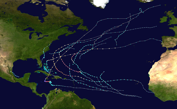
Most of the year’s 13 tropical storms and hurricanes veered off into the Atlantic before even reaching the Caribbean.

So, how does climate change influence the jet stream?
The strength of jet streams is controlled by the temperature contrast between the equatorial and polar regions.
A higher temperature contrast leads to stronger jet streams. As the planet warms, the Arctic is heating up at more than twice the global average rate, and that is reducing the equator-to-pole temperature difference. As that temperature gradient weakens, jet streams lose their strength and become more prone to stalling.

This increases the risk of persistent extreme rainfall events.
Weaker jet streams also meander more, producing larger waves and more erratic behavior. This increases the likelihood of unusual shifts, such as the southward swing of the jet stream in the summer of 2025.
A recent study found that amplified planetary waves in the jet streams, which can cause weather systems to stay in place for days or weeks, are occurring three times more frequently than in the 1950s.
As the global climate continues to warm, extreme weather events driven by erratic behavior of jet streams are expected to become more common. Combined with additional moisture that warmer oceans and air masses supply, these events will intensify, producing storms that are more frequent and more destructive to societies and ecosystems.
In the short term, the polar jet stream will be shaping the winter ahead. It is most powerful in winter, when it dips southward into the central and even southern U.S., driving frequent storm systems, blizzards and cold air outbreaks.
Shuang-Ye Wu, Professor of Geology and Environmental Geosciences, University of Dayton
This article is republished from The Conversation under a Creative Commons license. Read the original article.