#SanLuisValley poised to become a hub of renewable #solar generation — @AlamosaCitizen #ActOnClimate #KeepItInTheGround

A solar farm off CO 17 in Alamosa County. Photo by Owen Woods via The Alamosa Citizen

Click the link to read the article on the Alamosa Citizen website (Chris Lopez):

WHEN you drive across the expansive high mountain desert that is the San Luis Valley, you see acreage once irrigated through groundwater pumping wells now lying fallow. It’s a sight particularly evident in the central and western end of the Valley through Alamosa, Rio Grande and Saguache Counties, where the unconfined aquifer of the Upper Rio Grande Basin struggles from depletion due to overpumping of groundwater and decades of drought.

It’s one reality of the changing landscape that is on the minds of county officials and state leaders who represent the Valley and are trying to address ways the six-county region can at least partially replace some of its lost agricultural economy.

Another reality on the minds of local leaders is the fact that the San Luis Valley remains vulnerable to natural disasters and large-scale emergencies because there is no redundant power source to keep the Valley moving.

The vulnerabilities were demonstrated most recently both during the Spring Creek Fire in 2018 and the Boulder County fire of last December. In both situations the Valley lost critical power transmission and had no redundant system for backup power generation.

These realities are pushing local leaders to step before the Colorado Public Utilities Commission (CPUC) this month to say the San Luis Valley is interested in joining efforts of utility companies and the state to generate more renewable energy.

The clock to get involved is running, with the CPUC setting a Dec. 30 deadline to hear from interested parties on renewable energy and transmission development. Alamosa County, for one, is planning to step forward and raise its hand to let the Colorado Public Utilities Commission know that it has an interest in renewable solar generation and transmission development in the San Luis Valley.

“If we miss this and don’t act now, we will no longer be in the discussion and that’s actually what’s happened in the past,” said Alamosa County Commissioner Lori Laske.

“My concern is the redundancy and the safety of our Valley,” Laske said. “Second is with a larger (transmission) line to export our solar because right now we are maxed out with what we have.”

State Sen. Cleave Simpson and the local office of U.S. Sen. Michael Bennet have been convening local leaders this fall to work through initial conversations and to understand the opportunity the CPUC has created through what is known in the bureaucracy as a miscellaneous docket proceeding.

“The PUC is saying there’s value in evaluating the potential for solar generation and transmission in the Valley,” Simpson said.

The business case to be made is that from a solar perspective, the San Luis Valley produces 10 percent more power per solar panel than anywhere else in the state due to its base elevation of 7,500 feet and more days of sun than the Front Range and anywhere else in Colorado.

That’s according to Mike Krueger, president and CEO of the Colorado Solar and Storage Association, a nonprofit that is working with Valley leaders to get in front of the Colorado Public Utilities Commission.

“The Valley is the single best place in the state to produce those electrons,” Krueger said. 

“If you had the ability to export the generation from the Valley, you’d see I would suggest thousands of acres across the six counties that would be able to support solar down there. Literally the only thing stopping people is you can’t get the power out.”

A solar farm off CO 17 in Alamosa County. The San Luis Valley produces 10 percent more power per solar panel than anywhere else in the state due to its base elevation of 7,500 feet and more days of sun than the Front Range and anywhere else in Colorado. Photo by Owen Woods via The Alamosa Citizen

KRUEGER figures landowners could command lease payments anywhere from $500 to $1,000 per acre for solar development. Simpson said at that price, there would be a market in the Valley to generate more solar power.

In the Valley there is plenty of nonproductive ag land as a result of groundwater wells being permanently shut down in recent years, and more on the way.

The Rio Grande Water Conservation District Board of Directors is working through a set of criteria to help local farmers and ranchers apply for money to permanently retire more groundwater wells through the Groundwater Compliance Fund established through state legislation sponsored by Simpson.

Valley irrigators are expecting to tap into $30 million set aside through the state Groundwater Compliance Fund that could retire another 10,000 to 20,000 acres of irrigated farm land. It’s the need to permanently retire groundwater wells and continue to reduce the amount of crops produced in the San Luis Valley that has Simpson and others searching for alternatives.

“This community should come together and say to the PUC ‘This is a huge resource, we want this resource to be developed, you decide where it should go. Where’s the most benefit to the state of Colorado and the (power) system?’” Simpson said.

It’s a consensus that he and the local staff to Sen. Bennet have been working to build. Alamosa County is expected to formally get involved and take the Valley’s case to the CPUC.

“The cards are all lined up to go ‘Colorado has this expectation of being carbon-free, so does Tri-State, so does Xcel, and you have this resource here, we just don’t have any place to go with it,” Simpson said. “I think this is a window of opportunity that isn’t going to be here forever.”

Once you generate and store the solar, and you’ve established a redundant system of power for the San Luis Valley itself, it’s then transmitting the renewable solar energy for Xcel and Tri-State to use that makes the proposition tricky and challenging.

That’s a battle for down the road. For now it’s signaling to the Colorado Public Utilities Commission that the San Luis Valley wants to be involved in generating renewable energy and new transmission routes out of the Valley.

Krueger calls it YIMBY: A move to say “Yes In My Back Yard.”

San Luis Valley. Photo credit: The Alamosa Citizen

#NewMexico: #GoldKingMine spill settlement fund draws 17 proposals totaling $28 million — The Farmington Daily Times #AnimasRiver #SanJuanRiver

The orange plume flows through the Animas across the Colorado/New Mexico state line the afternoon of Aug. 7, 2015. (Photo by Melissa May, San Juan Soil and Conservation District)

Click the link to read the article on The Farmington Daily Times website (Mike Easterling). Here’s an excerpt:

New Mexico officials received 17 proposals totaling more than $28 million for the $10 million in Gold King Mine spill settlement money between the state and the U.S. Environmental Protection Agency that has been set aside for restoration projects. The deadline for submitting proposals for the settlement money was Oct. 28, a date that was extended from its original deadline of Sept. 30 by the New Mexico Office of the Natural Resources Trustee, the state agency that is coordinating the process. Maggie Hart Stebbins, the New Mexico natural resources trustee, said her agency has begun the process of vetting the proposals and will be analyzing them to determine if additional information is needed from any of the entities seeking the funding…

The $10 million is part of a $32 million settlement the state reached with the EPA earlier this year to compensate New Mexico for damages related to the August 2015 incident, during which millions of gallons of toxic waste were released from the abandoned Gold King Mine near Silverton, Colorado, eventually winding up in the Animas and San Juan rivers. A total of $18.1 million from that settlement was designated for response costs, while $3.5 million was set aside for water quality and cleanup activities through Clean Water Act and Superfund grants. The remaining $10 million has been earmarked for restoration of injured natural resources, much of which state officials said would be used to fund outdoor recreation opportunities in northwest New Mexico…

The list of proposals includes several projects submitted by government entities in San Juan County, as well as those associated with the Navajo Nation and the state of New Mexico. San Juan County submitted three proposals, while the City of Aztec submitted two, and the cities of Bloomfield and Farmington submitted one each. New Mexico State Parks led the way with four proposals, while the New Mexico Tourism Department submitted one.

New Mexico Lakes, Rivers and Water Resources via Geology.com.

Double Dead Pool on the #ColoradoRiver — InkStain @jfleck #COriver #aridification #CRWUA2022

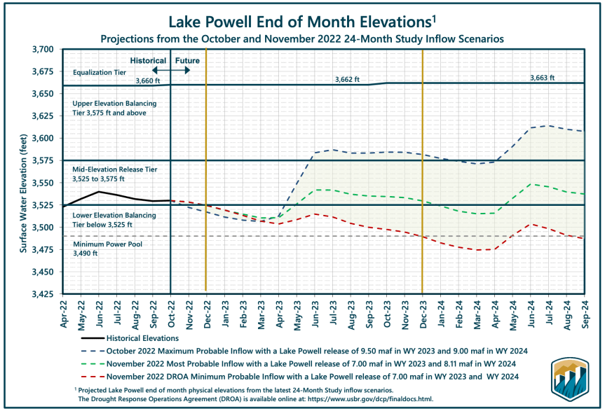
USBR graphic via John Fleck.

Click the link to read the article on the InkStain website (John Fleck):

The Bureau of Reclamation folks haven’t posted the slides yet from last week’s Supplemental Environmental Impact Statement briefings. In the meantime, some of us in the Colorado River nerd world have been passing around our screenshotted copies like some sort of precious mimeographed ’60s ‘zine.

It was a remarkable affair.

Buried in the tables and graphs was a sobering message: If we are to take climate change seriously, we need to be prepared for the possibility of:

  • driving Lake Mead to “dead pool” in order to protect the structural integrity of Glen Canyon Dam
  • driving Lake Powell below the critical power pool threshold, where Reclamation is forced to use Glen Canyon Dam’s dicey outlet works, in order to protect Lake Mead from reaching dead pool
  • releases from Lake Mead of as low as 3.8 million acre feet in a single near future year – a ~5 million acre foot reduction from current levels
  • Lake Powell releases dropping below the 10 year-by-75 million acre foot benchmark set by the Colorado River Compact. Not merely the 10×82.5 maf number that includes the Upper Basin’s share of the U.S. Mexican treaty obligation. Below 10x75maf.

To be clear, Reclamation is not projecting those numbers. Rather, this is the no-holds-barred reality check being offered by Reclamation’s technical team of a plausible scenario for which we need to be prepared.

Given the context in which these numbers are being offered – new operating rules under a revised version of the 2007 Interim Guidelines – it seems clear where this is headed.

REFILLING

First and foremost, if we have a wet year this year, we need to hold water back now. I can imagine, for example, a new rule that constrains releases from Glen Canyon Dam indexed to inflows – perhaps “don’t release any more water from Glen this year than last year’s unregulated inflow”. If my hypothetical rule takes evaporation into account, that would mean something around a 6maf Powell release in 2023.

Just hypothetically.

One of the flaws we can now clearly see in the ’07 guidelines is that they were keyed to reservoir elevations rather than the actual flow of the river, in a way that allowed us to drain Mead and Powell. We have a chance for a tweak to save us from the worst of that over the next few years. [ed. emphasis mine]

LOWER BASIN USE

Cutting Powell’s releases, as we must do, quickly crashes Lake Mead, pushing it well down into the ’07 guidelines shortage tiers. But the model runs presented by reclamation show those current shortage tiers won’t be enough.

So a new set of rules, to get us through the next few years, has to offer up much deeper Lower Basin cuts than the current rules in the ’07 guidelines and Drought Contingency Plan. It also seems clear, after staring at Reclamation’s slides from last week’s briefing, that we need the cuts to kick in sooner, at higher Mead levels, if we are to be prepared for the possibilities contemplated in the briefing. I’m intrigued by a “double DCP” notion that’s been kicking around the basin community, because it’s based on ratios for shortages among the Lower Basin states that have already been negotiated.

My back-of-the-envelope look at those numbers suggests to me that Double DCP at higher Mead elevations might be going a little harsh on Arizona and easy on California. Dunno. Thinking about equities, “present perfected rights”, Tribal water, environmental flows, and my friends in the Lower Basin gives me a headache.

But I’ve got plenty of aspirin and 16 days until Interior’s deadline for comments, so perhaps I’ll make it.

General Motors invests $500,000 in #SaltonSea restoration — The Palm Springs Desert Sun #ColoradoRiver #COriver #aridification #CRWUA2022

Click the link to read the article on the Palm Springs Desert Sun website (Janet Wilson). Here’s an excerpt:

Audubon California has received $500,000 from General Motors to help support its work on the fast-dwindling Salton Sea. Audubon will use the funds toward the design of public recreational facilities at its 900-acre Bombay Beach wetland restoration site; to conduct research into the lake’s biofilm, or bacterial species; to assess its overall ecosystem health; and to engage local communities on the future of the huge water body…

“The Salton Sea is an enormous resource to California, to the western United States, and the entire Western Hemisphere,” said Frank Ruiz, director of Audubon California’s Salton Sea Program. “That means more than just lithium extraction: The sea should provide recreational opportunities and badly needed access to the outdoors for residents of park-poor surrounding communities, as well as continue its role as a stopover of hemispheric importance to millions of migrating birds. We’re grateful to GM for this grant and its commitment to helping halt the sea’s decline.”

Sign for Bombay Beach. By The original uploader was Epolk at English Wikipedia. – Transferred from en.wikipedia to Commons., CC BY-SA 2.5, https://commons.wikimedia.org/w/index.php?curid=44026518

In a news release about the GM funding, Audubon California said the grant will help fund planning for infrastructure at Bombay Beach that will provide habitat for birds and threatened Desert Pupfish, control wind-blown dust off of drying, exposed lakebed, and provide educational features for visitors. The award also will help fund Audubon’s Salton Sea science staff, working with local environmental youth leaders, to take water and soil samples, survey bird populations and conduct other research, including the hiring of a local graduate student to investigate food availability for migratory shorebirds. In addition, Audubon will conduct outreach to and engage with local residents on issues pertaining to the sea.

A Century Ago, This Water Agreement Changed the West. Now, the Region Is in Crisis: Much has changed since the #ColoradoRiver Compact was signed in 1922 — Smithsonian Magazine #COriver #aridification #CRWUA2022

Dories at rest on a glorious Grand Canyon eve. Photo by Brian Richter

Click the link to read the article on the Smithsonian Magazine website (Margaret Osborne):

The Colorado River has long been regarded as the “lifeline of the Southwest.” It supplies water to 40 million people in seven states, 29 Native American tribes and parts of Mexico. Farmers use it to irrigate nearly 5.5 million acres of agricultural land. 

One hundred years ago this month, the signing of the Colorado River Compact laid the foundation for how water from the river is used today. But the signers of the 1922 agreement had no way of knowing what the future would bring. Decades of overuse because of faulty science and population growth—along with climate change—have all reduced the river’s flow and the water levels in the nation’s largest reservoirs, Lake Mead and Lake Powell. Now, the basin is facing a crisis.

“The conditions that we’re experiencing now are far worse than anyone anticipated them to ever be,” Crystal Tulley-Cordova, principal hydrologist at the Navajo Nation Department of Water Resources, tells Smithsonian magazine. 

So, how did the situation evolve into what it is today? And what comes next for the basin? Here are five things you should know about the 1922 agreement for its 100th anniversary.

Where is the Colorado River?

The 1,450-mile-long river begins in the Rocky Mountains of Colorado. It passes through Lake Powell, the Grand Canyon and Lake Mead before ending in Mexico’s Sonoran Desert. Altogether, its drainage basin spans about 246,000 square miles, representing 8 percent of the land in the continental United States.

While the river historically stretched all the way to the Gulf of California, damming and overuse have prevented the water from regularly flowing into the gulf since the 1960s.

Colorado River Allocations: Credit: The Congressional Research Service

What is the Colorado River Compact?

In the early 1920s, states in the Colorado River Basin grew concerned about their shares of water in the river. California was growing rapidly, and some feared it would establish priority access to the water.

Delph Carpenter, an attorney in Colorado, proposed that the states should come together to negotiate river water allocation. The states took 11 months to reach an agreement: the Colorado River Compact. It divided states in the watershed into an Upper Basin and a Lower Basin, which would each receive 7.5 million acre-feet of water per year. From there, the basins were left to figure out how to split up the water among themselves. 

In the decades following the compact, subsequent court cases, treaties and agreements hammered out exactly how the water would be distributed. Together, these are called the “Law of the River.”

From the 2018 Tribal Water Study, this graphic shows the location of the 29 federally-recognized tribes in the Colorado River Basin. Map credit: USBR

Who was involved, and who was not?

The compact was signed by delegates from seven states—Arizona, California, Colorado, Nevada, New Mexico, Utah and Wyoming—as well as a representative from the federal government, Secretary of Commerce Herbert Hoover. It was the first time so many states had come together to make an agreement—a momentous occasion in U.S. history. 

But while Native Americans had been using water in the river for millennia and had legal rights to it, per a 1908 Supreme Court case, they were left out of the agreement, as was Mexico.

All states ratified the compact except for Arizona. Its then-governor said the compact put Arizona at a disadvantage, because it would be forced to compete directly with California for water. Arizona later joined the agreement in the early 1940s, and the two states still face bitter disputes over water today.

A March 31, 1922 photo of the Colorado River Commission. Standing left to right: Delph E. Carpenter (Colorado), James G. Scrugham (Nevada), R. E. Caldwell (Utah), Frank C. Emerson (Wyoming), Stephen B. Davis, Jr. (New Mexico), W. F. McClure (California) and W. S. Norviel (Arizona). Seated: Gov. Emmet D. Boyle (Nevada), Gov. Oliver H. Shoup (Colorado), Herbert Hoover (federal representative and chair) and Gov. Merritt C. Mecham (New Mexico). The governors were not members of the Commission. Photo: Colorado State University Library

One century later, what has changed?

While the Law of the River still governs water use, conditions have shifted drastically in the 100 years since the compact was signed. Hoover predicted the basin’s population, which was about 457,000 in 1915, would quadruple. Today, the river serves 40 million people—more than 20 times his prediction. 

And states are now using more water than is sustainable. The 1922 negotiations allocated water use based on data from an unusually wet period in history, Brad Udall, a senior water and climate research scientist at the Colorado Water Institute at Colorado State University, tells Smithsonian magazine. Now, with reduced water in the river and its reservoirs, these allocations are outdated. The signers likely knew their agreement would create a long-term problem, some experts say, but they ignored the research and forged ahead anyway. 

Updated Colorado River 4-Panel plot thru Water Year 2022 showing reservoirs, flows, temperatures and precipitation. All trends are in the wrong direction. Since original 2017 plot, conditions have deteriorated significantly. Brad Udall via Twitter: https://twitter.com/bradudall/status/1593316262041436160

“Uses are somewhere on the order of about 15 million acre-feet. The historical flow since 2000 is around 12 million acre-feet,” Udall says. “We’ve got a 3 million acre-foot imbalance.”

Meanwhile, climate change is reducing the mountain snowpack that feeds the river, and it’s also causing more evaporation. Warmer, drier conditions have thrown the entire basin into a 23-year-long drought that is ongoing. But Udall and other scientists argue the word “aridification” is a more accurate term, since the conditions are unlikely to change.

“Since 2000, the basin has been in a state of profound imbalance,” Udall says. “As a result, the Colorado River reservoirs, the nation’s two largest reservoirs, have declined by roughly 70 percent.” 

The water shortage has forced the federalgovernment to take drastic action—it has ordered cuts to water usage and reduced downstream releases from the Glen Canyon and Hoover dams, which form Lake Powell and Lake Mead, respectively. But even these measures haven’t been enough.

Native American tribes, which were excluded from the original 20th-century negotiations, have inherent rights to the diminishing water supply—a combined total of about 20 percent of the river’s historical flow. But many tribes are still fighting for these rights to be recognized.

“While people are conserving, we’re trying to develop our water,” Tulley-Cordova says. “A large population of our nation still don’t have running water.”

Jack Schmidt, director of the Center for Colorado River Studies at Utah State University, tells Smithsonian magazine the situation is dire. One more extremely dry winter—on par with the record-breaking dry conditions that occurred in 2002—will either drain Lake Powell or force the government to take unprecedented emergency action, he says.

“We’re in abject crisis right now,” Schmidt says. “We’re on the edge of that cliff. We’re about to fall off.”

What’s next for the basin?

The basin faces an immediate crisis of dry conditions this winter. But it also faces the long-term crisis of overuse, says Schmidt. 

“We must, as a nation, reduce our long-term use rates to be consistent with the supply,” he says. “That’s just basic checkbook accounting.”

In 2026, several current agreements regarding water usage will expire, forcing new compromises to be made about water allocation. So far, though, no one has decided what those new rules will look like.

“I don’t know where we’re going. I don’t know that anybody would tell you where we’re going. But if we don’t make decisions fast, nature’s going to make them for us,” Udall says. “The real threat here is that we empty these two reservoirs and then become reliant on an annual allocation that nature provides, instead of an annual allocation that we humans decide what’s best for us.” 

But Udall says one reason to remain optimistic is that relationships between states and entities in the basin are good. And moving forward, Tulley-Cordova says that continuing to forge these relationships will be key.

“It’s not to say that we all agree on the way things should be done,” she says. “But the best [strategy for] talking about a complicated subject is not assuming what the other person’s priorities, needs, and challenges and opportunities are.” 

Still, scientists say action must be taken—and soon. With Lake Mead and Lake Powell at historic lows and the states failing to cut back their water use, it’s only a matter of time before nature forces the states to make uncomfortable decisions.

“It’s going to be a wild ride. That much, I can tell you,” Udall says. “We’re in a deep hole here.”