The High Plains Aquifer provides 30 percent of the water used in the nation’s irrigated agriculture. The aquifer runs under South Dakota, Wyoming, Nebraska, Colorado, Kansas, Oklahoma, New Mexico and Texas.
For the first time, the state board voted Wednesday to say that Kansas shouldn’t pump the Ogallala aquifer dry to support crop irrigation. The underground water source has seen dramatic declines in recent decades.
The board that advises the Kansas governor and Legislature on water policy now says the state needs to dramatically cut farming irrigation to stop draining the Ogallala aquifer. The vote by the Kansas Water Authority on Wednesday signals a call for a major shift in state policy. For the first time, a state entity has stated that Kansas should move away from gradually depleting the aquifer and act to halt the decline of the vital underground reservoir. Kansas Water Office director Connie Owen called the vote a historic step in changing how the state manages the aquifer, which has lost more than one-third of its water in recent decades.
“It is enormous,” Owen said, “because there has yet to be any state entity that has publicly acknowledged the problem … and made a statement that we can no longer behave as we have been.”
The water authority will now send this official recommendation to the governor and Legislature in its annual report.
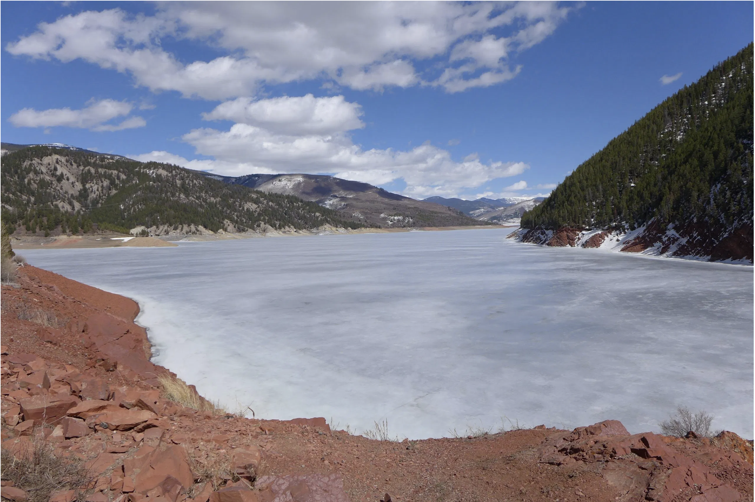
Ruedi Reservoir, near the headwaters of the Fryingpan River, was still frozen in early April 2021. CREDIT: HEATHER SACKETT/ASPEN JOURNALISM
From email from the Colorado Water Trust (Kate Ryan, Rick Lofaro, Brendon Langenhuizen, and Rob Viehl):
Colorado Water Trust and Roaring Fork Conservancy have teamed up with the Colorado River Water Conservation District (Colorado River District) and the Colorado Water Conservation Board to purchase and release water from Ruedi Reservoir to mitigate the impacts of anchor ice on the Fryingpan River. On Friday, December 16, the first release of water from Ruedi Reservoir will begin. The project aims to release 1.26 billion gallons of water (or 3,866 acre-feet) between December 16, 2022, and March 1, 2023, to the Fryingpan River, maintaining flows around 65 cubic-feet-per-second (cfs) in order to diminish ice buildup.
Anchor ice is a natural occurrence, but can have serious consequences on the hydrology of the river and the health of the ecosystem within. When there are low flows in the river during the cold winter months, large amounts of anchor ice can form on the bottom of the river, negatively impacting fish and macroinvertebrate function and diversity. Maintaining minimum winter flows between 60 to 70 cfs increases ecological resilience in the river through mitigating the formation of the anchor ice, and improving recovery from previous anchor ice impacts.
The partners will monitor the flow levels in the Fryingpan River, water temperature, air temperature, and anchor ice presence, from December through March. Anchor ice survey results will be compared to previous two years to continue to observe trends and build a long- term data set. “Roaring Fork Conservancy’s unique anchor ice monitoring program will allow us to objectively document anchor ice over time. This allows us to continue to promote management of Ruedi Reservoir with local benefits in mind” says Rick Lofaro, Executive Director of Roaring Fork Conservancy.
This month, the Great Outdoors Colorado (GOCO) board awarded a $34,700 grant to the Upper Gunnison River Water Conservancy District to address the urgent need to adapting the basin to ongoing drought conditions. This grant is part of GOCO’s Conservation Service Corps program. GOCO partners with Colorado Youth Corps Association (CYCA) to employ conservation crews across the state on outdoor recreation and stewardship projects. The youth corps represents a statewide coalition that train youth, young adults and veterans to complete land and water conservation work and gain professional skills. This funding will support the Upper Gunnison through a partnership with Western Colorado Conservation Corps crews for four weeks of stewardship work. Crews will construct beaver dam analogs — man-made structures designed to mimic the form and function of natural beaver dams — and implement other low-tech processes to speed channel recovery and support wetland and river vegetation. This project is part of the greater Upper Gunnison Basin Wet Meadow and Riparian Restoration Project, which has conducted restoration work in the area for the past decade.
At this morning’s [December 14, 2022] Upper Colorado River Commission (UCRC) meeting held in concert with the Colorado River Water User’s Association (CRWUA) Conference, the Commission formally released a Request for Proposal re-initiating a System Conservation Pilot Program (SCPP) beginning spring 2023. The Program aims to reduce consumptive use through temporary, voluntary, and compensated measures across the Upper Division States and allocates up to $125 million for the re-initiation with the potential to increase in scale. This action implements the first element of the UCRC’s 5-Point Plan released in July 2022.
Colorado River District General Manager Andy Mueller responded that a program of this scale and speed poses as much risk and opportunity as a Demand Management program, therefore it is critical how the program is implemented.
“It is vital to the health of our communities and our agricultural industry that the River District have a decision-making role in this program, consistent with past implementation of a previously-authorized System Conservation Pilot Program, and we want to thank Commissioner Mitchell for her commitment to recognize the River District’s role in that effort,” Mueller said.
Commissioner Mitchell provided a written commitment stating that “in the event the source of the water and the place of beneficial use of a prospective applicant’s SCPP project is located within the boundaries of the District, enrollment in the SCPP will be subject to approval of the application by both the Colorado Water Conservation Board (CWCB) and the District.”
In Commissioner Mitchell’s own release today, she stated, “We must continue to live within the means of what the river provides year to year and we ask others to do the same. This is the only way the system will continue as we know it into the future.”
Southern California water agencies have agreed on a deal to cut back on the amount of water they use for the Colorado River, some of which is used to grow crops in the Imperial Valley. Ted Wood/The Water Desk
Alex Jack says he’s not charged enough for the water he uses at his Imperial Valley farm. Because the Colorado River water shared by him and his neighboring farmers who make up the vast agricultural economy in the middle of the desert is so cheap, he says, farmers have little incentive to conserve.
Jack, though, spends a lot of money to save water through a huge system of irrigation hoses that push water to the root of his Little Gem lettuce plants, drop by drop. The cost to run his 3,200-acre ranch is astronomical for the area, reaching upwards of $1 million a week during the busy season to power and pay for what functions like his own water district, circulating used water back to the top of his fields and storing excess in a private reservoir.
“Everything I do is to be a better farmer,” Jack, 64, said. “If I happen to conserve water in the process, that’s great. But they’re subsidizing the people that aren’t conserving water … It’s like politicians giving away free ice cream to everybody, then everyone is happy.”
The “they” Jack refers to is the Imperial Irrigation District, a public water and power utility that manages miles of canals delivering Colorado River water to farmers and residents of the valley.
Colorado River water was virtually free in the early 20th Century when pioneers dug the valley’s first canals that would later transform this desert landscape into a $2 billion agricultural industry. Imperial Valley farmers now pay about $20 an acre foot to transport Colorado River water to their fields, a price unchanged since 2011. An acre foot is enough water to fill an acre of land, one foot deep or how much an average California home uses both indoors and outdoors.
Farmers next door in San Diego County pay between $799 and $1,109 per acre foot. Even the Coachella Valley Water District, just north of Imperial Valley, charges farmers about $37 per acre foot, nearly twice what the Imperial Irrigation District charges its farmers.
Because water is so cheap, Imperial Irrigation District doesn’t make enough selling it to cover expenses on water revenues alone. Instead of charging farmers the full cost of water transportation to the valley, the district reinforces its budget by selling conserved water to San Diego, among a few other regions, at higher prices.
In the late 1990s, San Diego decided to diversify its water sources after a drought caused cutbacks from its only supplier, the Los Angeles Metropolitan Water District. San Diego made a deal to pay for water conservation on Imperial Valley farms in exchange for some of their Colorado River water. In the water policy world, that deal is known as the QSA or “quantification settlement agreement,” and it’s one of the largest transfers of water from agriculture to an urban area in U.S. history.
As a custom farm management company, we seek to provide the best farm services to you. We have many in-house services that belong to Bloom to Box Crop Care, Inc. (BTB) and we are always evolving and to keep up with the latest farm integrations to be the most efficient, productive, and cost-effective for our clients.
But IID doesn’t spend most of that money on conservation. It uses a large portion of those San Diego dollars to pay for employees that manage water deliveries and maintain canals and operate on good financial footing.
“Without the QSA, the growers would either have a very small water department and not the best service or they would have a rate increase by now,” said Tina Shields, water department manager at the Imperial Irrigation District.
Shields thinks increasing the water rate is a good idea but it puts the board elected to run the Imperial Irrigation District in a tough spot. The board is set to gain two new directors this year.
A member of that board, JB Hamby, who was elected in 2020 said he’s been floating the rate increase idea with farmers recently. The 26-year-old director acknowledged the issue has been mired by controversy in the past as farmers and the board worked through disagreements over water conservation largely sparked by the San Diego deal.
“We’re in a new era with a new set of (board members) and realities we’re experiencing,” Hamby said. “Let’s take a fresh look at what we’re doing and set rates according to what it actually takes to deliver the water here.”
Director JB Hamby represents Division 2 on the IID Board of
Directors, which includes southeast El Centro, Heber, Holtville, and
Seeley. He also serves on the Colorado River Board of California as
the representative for IID and as the Chairman of the Coachella Valley
Energy Commission. Photo credit: Imperial Irrigation District
The valley can’t ask San Diego for any more money. The price of the QSA is locked in until 2045.
Jack’s argument is simple: If farmers paid the true cost of water delivery, that could generate millions for farm conservation, and could free up more drought-stretched Colorado River water for others in the basin.
The true cost of water delivery varies depending on who you ask. Most agree, including director Hamby, the price hovers around $40 an acre foot – double what farmers pay now.
Jack is first to say his opinion is probably an unpopular one. But another key farming leader in the valley agrees.
Mark McBroom, 63, farms citrus and Medjool date groves on the valley’s northwestern corner flanked by sandy, arid federal land. He chairs the Agricultural Water Advisory Committee, a group of over a dozen water users appointed by elected Imperial Irrigation District board members. McBroom said he’s been pushing a higher water price for years.
“You have a lot of farmers on the fence because they don’t use the (conservation) program that much,” McBroom said. “And they enjoy the $20 price for farming their hay and their grass and things like this. They’re not a big proponent of this.”
One of those on-the-fence farmers is Trevor Tagg, 36, of West-Gro Farms, which grows dehydrated onions and forage crops, like alfalfa and Bermuda grass and sunflower.
“Everything is incredibly expensive right now in these forage commodities that I live and die by,” Tagg said. “Right now, the market for those crops is very high. But if they fall apart, and if we stick ourselves with more than double our water rate, we might solve the Lake Mead problem but you won’t see shit for forage commodities. I’m fearful of that.”
Hoover Dam’s intake towers protrude from the surface of Lake Mead near Las Vegas, where water levels have dropped to record lows amid a 22-year drought. (Source: Bureau of Reclamation)
Shrinking Colorado River Resources Squeeze Farms, Cities
Lake Mead is the Colorado River’s largest reservoir located behind Hoover Dam just outside of Las Vegas. The water level there signals the health of the rest of the river, which powers a massive agricultural industry and provides drinking water for millions of people living in seven states and two countries.
The West is experiencing such severe climate change-driven drought, the water level at Lake Mead dropped lower than ever before this year. To refill the reservoir, the federal government is coaxing states to reduce water demand by fallowing farms and flipping lawns into desert landscape. If states can’t agree, and water levels keep dropping, the federal government can set mandatory cuts following “the law of the river.”
That law is really a set of agreements and contracts made over a hundred years ago when expansionists first settled the West. They dictate a pecking order as to who loses river water depending on availability at Lake Mead. Imperial Irrigation District is virtually last in line to be cut by force.
Arizona, Nevada and Mexico are first in line and already face mandatory water cuts next year. California, under those century-old agreements, is in the clear for now. But political pressure from states that aren’t is mounting, so some of California’s biggest water users – including Imperial Irrigation District – tentatively agreed to voluntarily conserve 400,000-acre feet in 2023. California’s full share is 4.4 million-acre feet. Imperial Valley has a right to 3.1 million of that..
While that 400,000-acre feet savings seems a drop in the bucket, farmers in Imperial Valley, whose legal rights to water remain ironclad, will have to come up with over half of that. It ruffled feathers.
On Nov. 17, the Imperial County Farm Bureau sent a letter to the U.S. Bureau of Reclamation, the federal body that determines what happens along the Colorado River, restating their commitment to conserve an additional 250,000-acre feet. The bureau scolded the feds for failing to push other Colorado River basin states into a deeper state of mandatory drought conservation. That harsher scenario would force a canal serving Arizona cities like Phoenix to take an even larger hit and require other areas of California to take a cut for the first time.
Conserving more water in Imperial Valley “will however come at a great expense to our farmers, the IID and disadvantaged community whose main source of income comes from agriculture,” the letter reads.
The Bureau of Reclamation, in hopes of securing voluntary commitments to use less water, offered in August to pay farmers up to $400 per acre foot of water conserved. That’s not enough, the bureau wrote, to meaningfully impact the water levels at Lake Mead.
It is, however, more than Imperial Irrigation District pays them from San Diego dollars. Payments to add equipment like sprinklers, drip irrigation and other accouterments that help efficiently water crops average about $217 per acre foot of water saved. That reimbursement rate has dropped from $285 per acre foot in 2013 when the farm conservation program really kicked off.
Ranchers like Larry Cox, whose family farmed Imperial Valley since the 1950s, has long held Imperial Irrigation District’s payments weren’t enough to cover ever-skyrocketing labor and diesel costs. Cox said valley farmers mistrust their utility. He supports raising the price of water to reflect the cost of delivery but wants certainty that extra money would be spent on the land itself.
“Imperial Irrigation District needs to be held accountable for doing a good job of delivering that water,” Cox said.
Farmers Fear Fed’s Biggest Stick
A looming threat lingers over Imperial Valley that, if the drought worsens and states relying on the Colorado River can’t agree to save lots of water, the federal government might force farmers to fallow their ground, in other words, stop planting and, therefore, irrigating. That threat has a name: the 417 proceeding.
Farmers met the deal to give San Diego a portion of Imperial Valley’s water back in 2003 with fierce resistance at the start. So much so that the federal government leaned on the 417 proceeding, which served as a notice the government could cut how much water Imperial Valley farmers ordered that year from the Colorado River, if the valley didn’t come to terms with San Diego.
The 417 dictates water use should be both “reasonable and beneficial,” a broad definition in Western water law. It’s a box to check for all Colorado River water users each year, but during times of scarcity – like right now – water users are waiting to see whether the federal government might decide certain uses are unreasonable, like watering lawns or flooding crops with water, the traditional irrigation method in Imperial Valley.
“As water has become tighter and tighter the meaning of 417 is pretty clear,” Jack, the farmer, said. “You can’t just go out there and waste water. Using pump backs or drip irrigation puts you in that category of reasonable and beneficial, and therefore, no one should be able to take away your water.”
In other words, he views voluntary conservation as preemptive protection against the heavy hand of the federal government.
During a June meeting, fears of a 417 process resurfaced. Imperial Valley farmer Ronnie Leimgruber criticized the Imperial Irrigation District for poor management of the farming conservation program backed by San Diego dollars. Over the last two years, Leimgruber said, he spent $2.5 million on water conservation projects on his land but the utility still hasn’t reimbursed him.
“The only way we can improve our chances on a 417 is with water conservation projects on farms,” Leimgruber said. “The only way we can do that is if the district improves the way we do on-farm conservation. We need a way to insulate ourselves from the 417.”
Hamby said the utility’s had limited staff resources to focus on changes to the program made by previous leadership. He hopes the new board could use years’ worth of data from the program to make payments more predictable.
In the meantime, water agencies across the West are waiting to hear what the federal government might say about their water orders for 2024.
“It’s important we understand we’re being scrutinized and doing our part protecting our resources and maximizing beneficial use,” Hamby, the water district board director said.
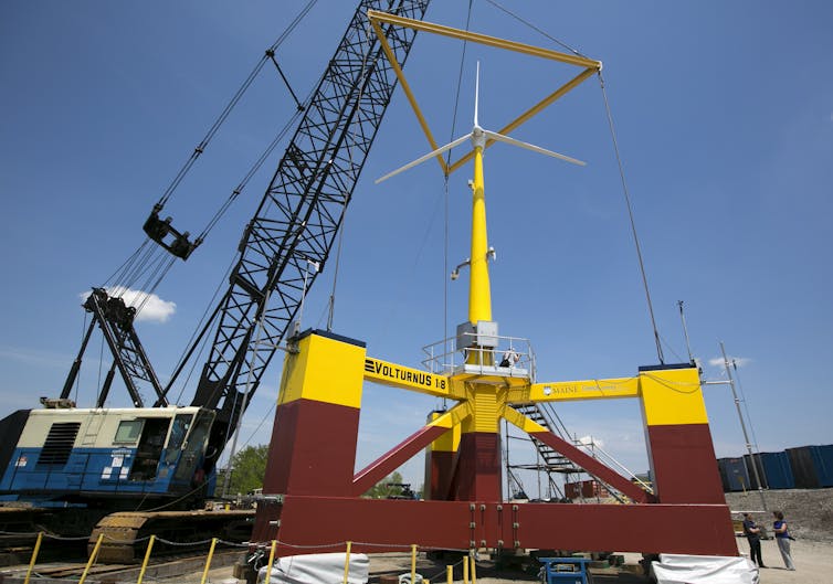
Northern California has some of the strongest offshore winds in the U.S., with immense potential to produce clean energy. But it also has a problem. Its continental shelf drops off quickly, making building traditional wind turbines directly on the seafloor costly if not impossible.
Once water gets more than about 200 feet deep – roughly the height of an 18-story building – these “monopile” structures are pretty much out of the question.
A solution has emerged that’s being tested in several locations around the world: wind turbines that float.
In California, where drought has put pressure on the hydropower supply, the state is moving forward on a plan to develop the nation’s first floating offshore wind farms. On Dec. 7, 2022, the federal government auctioned off five lease areas about 20 miles off the California coast to companies with plans to develop floating wind farms. The bids were lower than recent leases off the Atlantic coast, where wind farms can be anchored to the seafloor, but still significant, together exceeding US$757 million.
So, how do floating wind farms work?
Three main ways to float a turbine
A floating wind turbine works just like other wind turbines – wind pushes on the blades, causing the rotor to turn, which drives a generator that creates electricity. But instead of having its tower embedded directly into the ground or the seafloor, a floating wind turbine sits on a platform with mooring lines, such as chains or ropes, that connect to anchors in the seabed below.
These mooring lines hold the turbine in place against the wind and keep it connected to the cable that sends its electricity back to shore.
Most of the stability is provided by the floating platform itself. The trick is to design the platform so the turbine doesn’t tip too far in strong winds or storms.
Three of the common types of floating wind turbine platform. Josh Bauer/NREL
There are three main types of platforms:
A spar buoy platform is a long hollow cylinder that extends downward from the turbine tower. It floats vertically in deep water, weighted with ballast in the bottom of the cylinder to lower its center of gravity. It’s then anchored in place, but with slack lines that allow it to move with the water to avoid damage. Spar buoys have been used by the oil and gas industry for years for offshore operations.
Semisubmersible platforms have large floating hulls that spread out from the tower, also anchored to prevent drifting. Designers have been experimenting with multiple turbines on some of these hulls.
Tension leg platforms have smaller platforms with taut lines running straight to the floor below. These are lighter but more vulnerable to earthquakes or tsunamis because they rely more on the mooring lines and anchors for stability.
Each platform must support the weight of the turbine and remain stable while the turbine operates. It can do this in part because the hollow platform, often made of large steel or concrete structures, provides buoyancy to support the turbine. Since some can be fully assembled in port and towed out for installation, they might be far cheaper than fixed-bottom structures, which require specialty vessels for installation on site.
The University of Maine has been experimenting with a small floating wind turbine, about one-eighth scale, on a semisubmersible platform with RWE, one of the winning bidders. AP Photo/Robert F. Bukaty
Floating platforms can support wind turbines that can produce 10 megawatts or more of power – that’s similar in size to other offshore wind turbines and several times larger than the capacity of a typical onshore wind turbine you might see in a field.
Why do we need floating turbines?
Some of the strongest wind resources are away from shore in locations with hundreds of feet of water below, such as off the U.S. West Coast, the Great Lakes, the Mediterranean Sea and the coast of Japan.
Some of the strongest offshore wind power potential in the U.S. is in areas where the water is too deep for fixed turbines, including off the West Coast. NREL
The U.S. lease areas auctioned off in early December cover about 583 square miles in two regions – one off central California’s Morro Bay and the other near the Oregon state line. The water off California gets deep quickly, so any wind farm that is even a few miles from shore will require floating turbines.
Once built, wind farms in those five areas could provide about 4.6 gigawatts of clean electricity, enough to power 1.5 million homes, according to government estimates. The winning companies suggested they could produce even more power.
But getting actual wind turbines on the water will take time. The winners of the lease auction will undergo a Justice Department anti-trust review and then a long planning, permitting and environmental review process that typically takes several years.
Globally, several full-scale demonstration projects with floating wind turbines are already operating in Europe and Asia. The Hywind Scotland project became the first commercial-scale offshore floating wind farm in 2017, with five 6-megawatt turbines supported by spar buoys designed by the Norwegian energy company Equinor.
While floating offshore wind farms are becoming a commercial technology, there are still technical challenges that need to be solved. The platform motion may cause higher forces on the blades and tower, and more complicated and unsteady aerodynamics. Also, as water depths get very deep, the cost of the mooring lines, anchors and electrical cabling may become very high, so cheaper but still reliable technologies will be needed.
But we can expect to see more offshore turbines supported by floating structures in the near future.
This article was updated with the first lease sale.
But what actually happened up in the clouds to drop this snow that many claim to be so special? Gannet Hallar, director of Storm Peak Laboratory at the top of Mount Werner and a professor with the University of Utah, said it starts with the snowflakes.
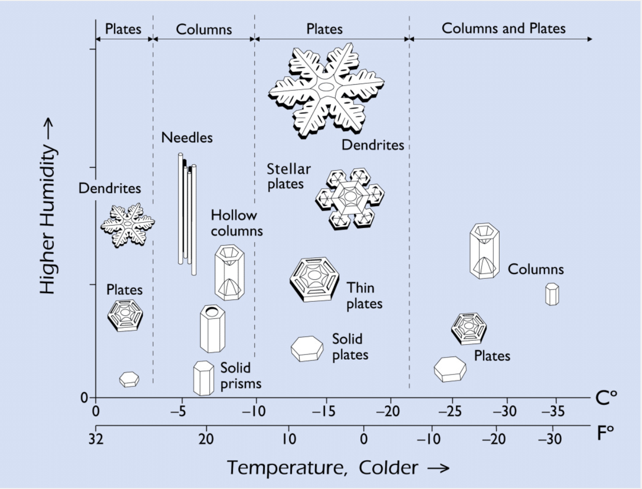
“If you have the perfect snowflake, which we tend to call a stellar dendrite, it has a lot of air and not so much water in its formation,” Hallar explained. “What allows for those types of snowflakes to form is both the temperature and the amount of water in the air as the snowflake forms within the cloud itself.” Snow often starts as dust, which then forms ice. As the ice builds outward, its shape is based on the amount of water and the temperature. Hallar said warmer temperatures allow for higher water content, while colder temperatures often bring lighter, drier snow.,,
This graphic created by Kenneth G. Libbrecht, a professor at the California Institute of Technology, shows the relationship between moisture and temperature when snowflakes are formed.
Kenneth G. Libbrecht/California Institute of Technology
Local meteorologist Mike Weissbluth said this relationship can be seen by looking at data from Storm Peak Lab from this week. At about 6 p.m. Monday, Dec. 12, as the storm front moved in, the temperature started dropping…Weissbluth said those low temperatures, combined with the right amount of moisture, put Steamboat in the center of the dendritic growth zone, which allowed the flakes to quickly pile up a fresh blanket of low density snow. The snow’s density is lower because the bigger the dendrites, the looser the snow packs and the more air is mixed in. While snow elsewhere can have a 15% water content, the powder in Steamboat tends to be closer to 7%, Hallar said. Another key factor in Steamboat’s snow is the geographic location, right next to a large wall that is the Park Mountains. Hallar said this process of wringing moisture out of the clouds as they rise is called orographic lift, and puts Steamboat in prime powder position.
From email from the Nature Conservancy (Lindsay Schlageter and Maggie Fitzgerald):
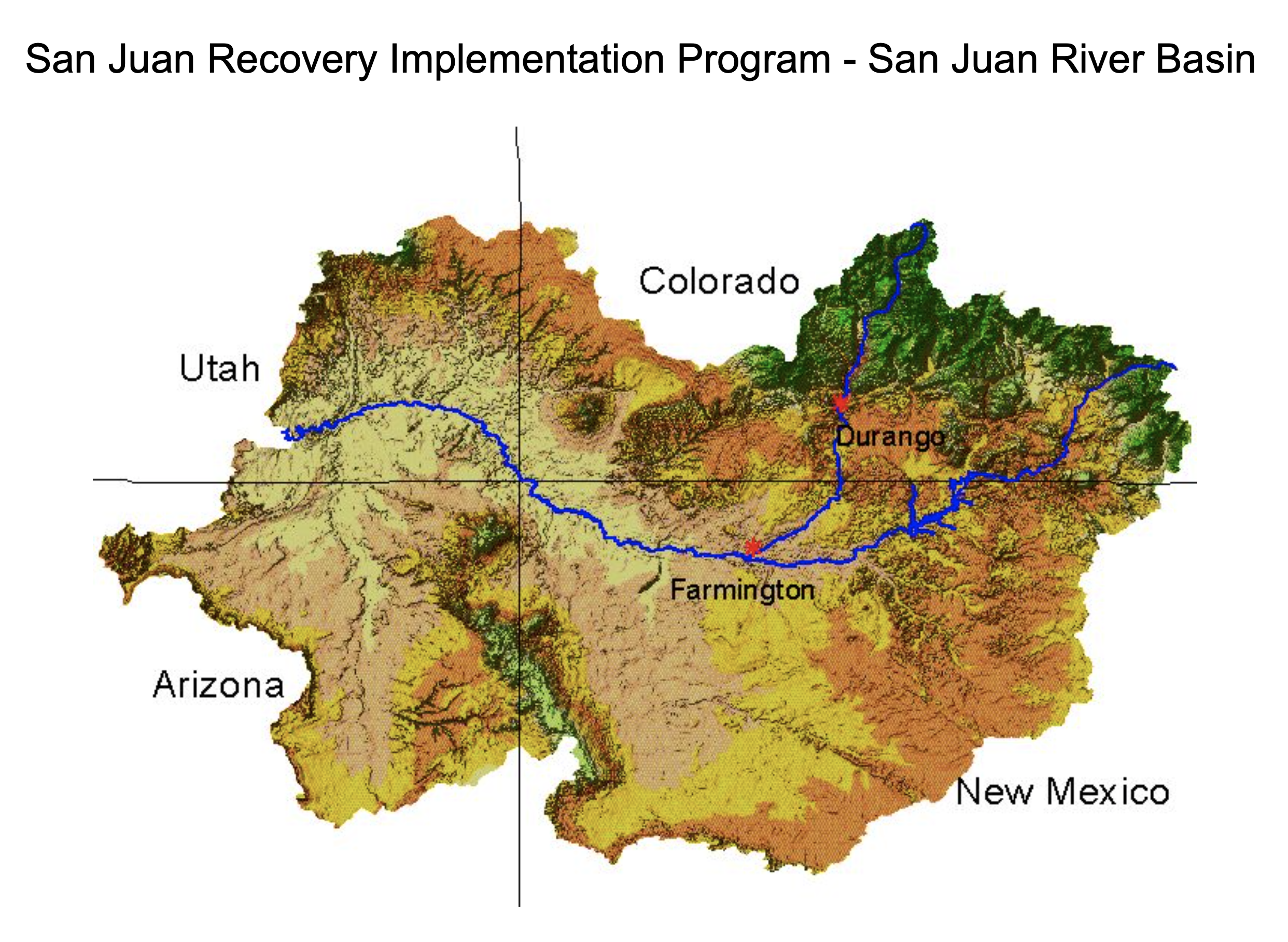
Today [December 14, 2022] the Jicarilla Apache Nation (Nation), New Mexico Interstate Stream Commission (NMISC) and The Nature Conservancy (TNC) announced the next phase in their Water Supply Agreement (agreement) that was reached earlier this year. With final federal and state approvals secured, the NMISC has placed an order for all 20,000-acre feet of water and the Nation has approved and reserved the water to be released from Navajo Reservoir to the San Juan River in 2023.
In January 2022, the partners signed a first-of-its-kind agreement that allows the NMISC to lease up to 20,000-acre feet of water per year (for 10 years) from the Nation to benefit threatened and endangered fish and increase water security for New Mexico. As the western US faces its driest period in 1,200 years, this agreement demonstrates how Tribal Nations and state governments can work on a sovereign-to-sovereign basis–with support from conservation organizations–to find collaborative solutions that benefit multiple interests and users of the San Juan and Colorado rivers.
“The Jicarilla Apache Nation looks forward to the implementation phase of this project and hopes that this transaction can serve as a model across the Basin for collaboration with conservation organizations, negotiation of arms-length sovereign-to-sovereign agreements, and development of creative solutions that serve multiple interests,” said Jicarilla Apache Nation President Edward Velarde.
The partners are exploring multiple options about when and how the water will be released in 2023. The decision on timing will be made by the lease agreement parties with input from scientists to determine the best outcome for endangered fish species. Scientists are working on a plan to monitor how the habitat for endangered fish reacts to the release and will use the information garnered to help make decisions for future releases.
“The NMISC is pleased that we are able to support this important project through New Mexico’s Strategic Water Reserve,” said NMISC Director Rolf Schmidt-Petersen. “We want to be sure we’ve carefully thought through the logistics of the first water release and seize the opportunity to measure benefits to the razorback sucker and Colorado pikeminnow.”
This project will use the Nation’s water temporarily placed in the State of New Mexico’s Strategic Water Reserve for the two purposes of the Strategic Water Reserve: 1) to assist the State in complying with interstate stream compacts and court decrees, and 2) to assist the State and water users in water management efforts to benefit threatened or endangered species.
“The Colorado River is in an unprecedented crisis,” said Celene Hawkins, Colorado River tribal partnerships program director for The Nature Conservancy. “Communities must proactively work together, focusing on water conservation and management. This project is a step toward those goals, and we are thrilled to be a part of this great partnership.”
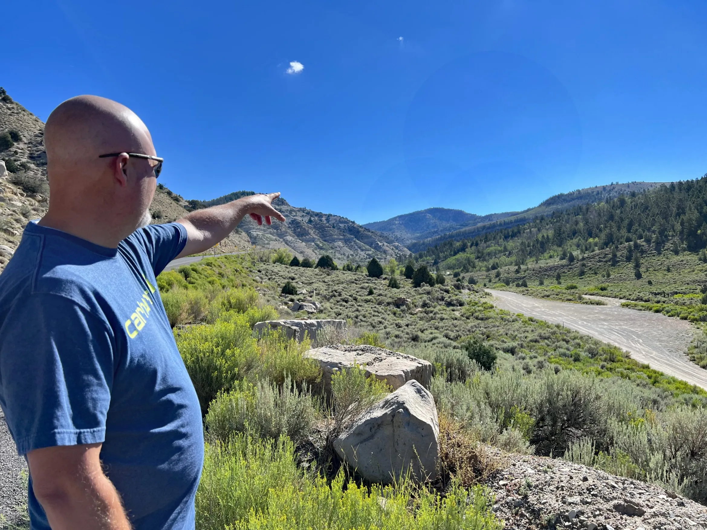
Darrell Fordham points toward a tunnel entrance for the proposed Uinta Basin Railway that would run near a mountain retreat property he owns in Argyle Canyon, Utah. U.S. Highway 191 is on the left in the photo. CREDIT: AMY HADDEN MARSH/ASPEN JOURNALISM
Darrell Fordham is heartbroken. It took years for the resident of Lehi, Utah, to purchase 20 acres above Utah’s Argyle Canyon and build a cabin for family retreats. “I’ve sunk about $150,000 into that property,” he told Aspen Journalism. “We bought it back in 2006 just as a place to raise our kids. Get ’em out of the city, get ’em unplugged and off the cellphones.”
The cabin is at about 6,000 feet at the edge of the Ashley National Forest on the West Tavaputs Plateau, surrounded by aspens and conifers in a small, tightknit, off-the-grid community known as Argyle Canyon Estates. “Being off-grid and about 3 1/2 miles off the pavement, the quiet is the whole appeal of that property,“ said Fordham. But that quiet is in jeopardy due to the proposed Uinta Basin Railway (UBR).
The UBR is not yet under construction but received necessary approvals from the Federal Surface Transportation Board (FSTB) in December 2021 and the U.S. Forest Service in July 2022. The 88-mile-long railroad would connect the fracked-oil fields in northeast Utah’s Uinta Basin to the national rail network. The crude would then be transported in heated tanker cars through Colorado on its way to Gulf Coast refineries.
Fordham began organizing his neighbors against the UBR in 2019 when it looked like two potential alignments — the Indian Canyon route and the Wells Draw route — would run through local properties and uncomfortably close to his community. As the Argyle Wilderness Preservation Alliance, the community wrote letters against the UBR in July 2020, shortly after the Seven County Infrastructure Coalition (SCIC), a quasi-governmental board created in 2014, applied for approval from the FTSB. Fordham said the group hired a lawyer that year and filed lawsuits in Utah district court but to no avail.
In 2014-15, 26 potential UBR routes were identified in Utah Department of Transportation feasibility studies, but none passed the initial screening process. Five years later, the SCIC added the Indian Canyon, Wells Draw and Craig routes as alternatives. The Craig and Wells Draw routes were eventually scrapped. The Indian Canyon route morphed into the preferred 88-mile Whitmore Park route, named for a large valley south of the Tavaputs Plateau.
According to maps provided by Fordham, the Whitmore Park route would still pass 2,550 feet from his property line. He said it feels as if his concerns have fallen upon deaf ears. “I think it’s communities like ours that are impacted by things like this because we’re just common people,” he said. “We don’t have hundreds of thousands of dollars to fight the government and the big oil companies, so they know they can just run it right over the top of us and there’s really nothing we can do about it.”
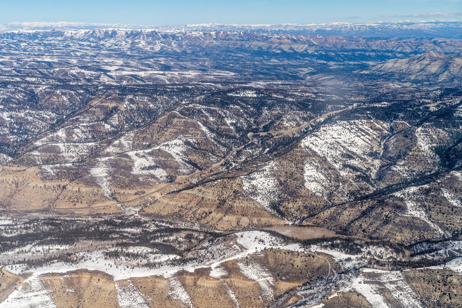
Overview of Argyle Canyon area that would be impacted by the proposed Uinta Basin Railway.
CREDIT: PHOTO COURTESY OF ECOFLIGHT
FSTB legal appeals in the works
In February, environmental groups and Eagle County filed separate appeals in response to the FSTB’s decision last December to approve the UBR. (The two cases have since been consolidated.) At issue are the approval decision and the U.S. Fish and Wildlife Service’s September 2021 biological assessment, upon which the FSTB relied to make its decision.
Most Uinta Basin oil is trucked to refineries in Salt Lake City, but production is capped at 80,000 to 90,000 barrels per day due to air pollution restrictions on the Wasatch Front. By connecting the Uinta Basin fracked-oil fields to the national rail line at Kyune, Utah, the UBR promises to quadruple production by bringing Uinta Basin crude — which must be heated for transportation purposes so that it doesn’t solidify — to the global market.
But increased oil production means increased air pollution in the Uinta Basin. Ted Zukoski, CBD attorney, told Aspen Journalism that air pollution in the basin is already listed as marginal. “This means it’s on the edge of becoming a nonattainment area because of wind inversions that trap pollution from drilling in the basin and lead to very unhealthy air quality.”
A 2013 study by state and federal agencies revealed federal ground-level ozone standards violations in the basin due to oil and gas production. In 2016, the state of Utah recommended nonattainment designations for National Ambient Air Quality Standards in five Utah counties, including Duchesne and Uintah, both in the Uinta Basin. A lag in oil and natural gas production lowered methane levels from 2015 to 2020. But methane leaks in production infrastructure effectively canceled out those gains. As of October, the Uinta Basin remains in nonattainment status.
Zukoski said the FSTB ignored the air pollution impacts and the downstream impacts of greenhouse gases released from consumers burning gasoline refined from Uinta Basin crude. “It could lead to as much as 53 million tons of additional CO2 going into the atmosphere,” he said. “The Forest Service knows how bad climate change is, so it’s hypocritical for this agency to support this project.”
Eagle County argues that the FSTB failed to look at the cumulative impacts of increased rail traffic on the Union Pacific line, which passes through the county, and possible impacts should Colorado’s Tennessee Pass railway be reactivated. County officials added that the scope of the FSTB’s environmental analysis was too narrow, focusing only on the 88 miles of the UBR in Utah.
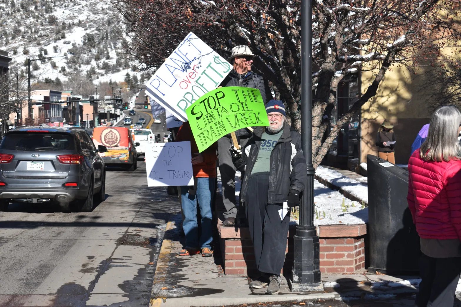
A man holds a picket sign that reads “Stop the Uinta Oil Train Wreck” in Glenwood Springs on Saturday, Dec. 10.
CREDIT: RAY K. ERKU/GLENWOOD SPRINGS POST INDEPENDENT
Colorado officials join the legal fray
In late October, the city of Glenwood Springs and the towns of Minturn, Avon, Red Cliff and Vail filed an amicus brief in support of Eagle County and the FSTB appeal. Karl Hanlon is an attorney with Karp, Neu, Hanlon, a Colorado firm that works with the cities of Glenwood Springs, Minturn and Red Cliff.
“What’s being proposed is 18 miles a day of train cars on the main [Union Pacific] line going through the city of Glenwood Springs and passing alongside the Colorado River through Garfield, Eagle and Grand counties,” he told Aspen Journalism. “The risks are tremendous with regard to the potential for an accident, the socio-economic impacts and the environment.”
Hanlon added that the FSTB did not consider whether running up to 185,000 heated tanker cars full of waxy crude alongside Interstate 70 is a good idea, particularly through Glenwood Canyon. The 2020 Grizzly Creek Fire shut down I-70 through the canyon for two weeks. Rockslides and mudslides from heavy rains the following summer closed the canyon again, resulting in lengthy detours for commercial trucks and other traffic, and decimating the Glenwood Springs economy at the height of tourist season.
“One major incident in Glenwood Canyon ends the livelihood of Glenwood Springs,” said Hanlon. “Not only is it a huge environmental disaster that is almost impossible to clean up, it will be the death knell for the community.”
He said the FSTB’s decision ignored Coloradans. “Frankly, the board just kind of thumbed their nose at all these communities,” he said. “FSTB focused on the 88 miles of new line in Utah and did their entire analysis there.”
Routt, Boulder, Chaffee, Lake and Pitkin counties, near the Union Pacific line, also signed on to the amicus brief. Routt County Manager Jay Harrington told Aspen Journalism that U.S. Highway 40 is the main northern traffic detour when I-70 is closed. “A rail accident does not have to occur close to Routt County to cause problems,” he said. “Every time I-70 [in the Glenwood Canyon ] is closed, traffic is rerouted right through here.”
The amicus brief references climate change impacts, wildfire risks from heated train cars, and the domino effect of an oil spill on downstream Colorado River users. Hanlon said the FSTB should start over and revisit the indirect impacts, including communities outside Colorado. “That waxy crude has to go a long way to get to a refinery,” he said. “There are communities all across the [country] going down towards the Gulf Coast that are facing similar impacts from this.”
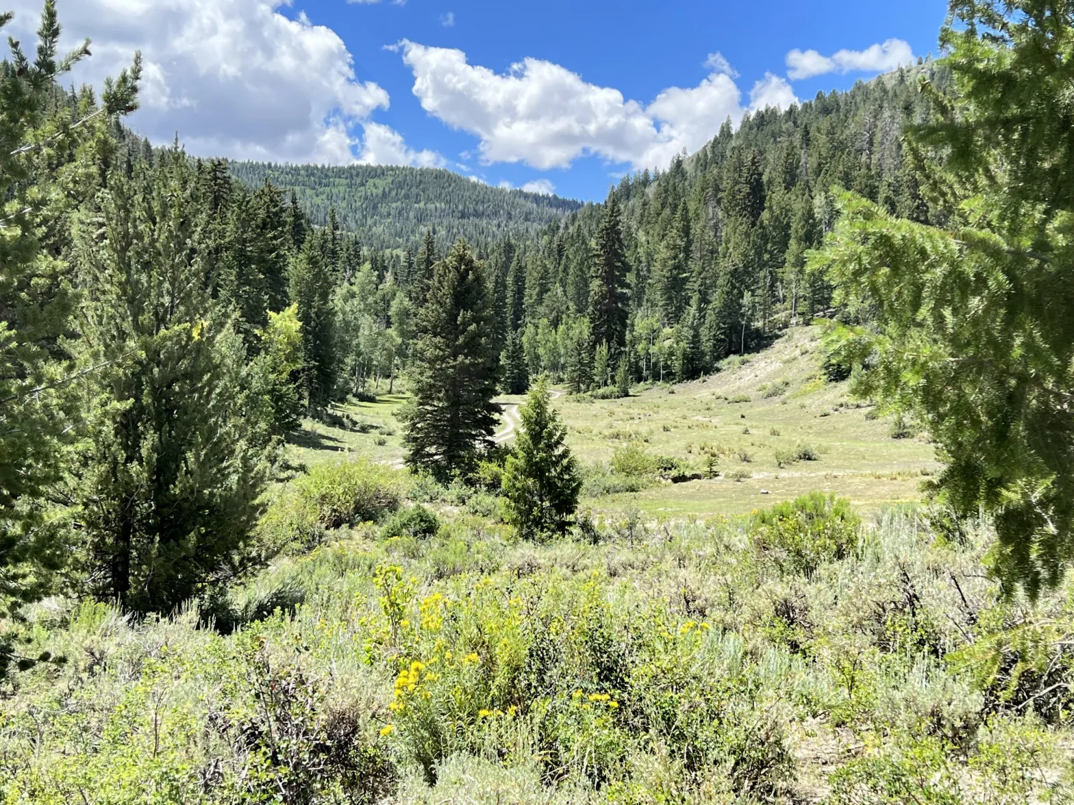
Dirt track to the right leads to a borehole site for a tunnel under the Ashley National Forest roadless area, part of the Uinta Basin Railway proposal which U.S. Forest Service officials approved in July.
CREDIT: AMY HADDEN MARSH/ASPEN JOURNALISM
USFS:A railroad is not a road
The Forest Service greenlighted a 12-mile stretch of the Whitmore Park route in July that would cut through an inventoried roadless area (IRA) in the Ashley National Forest. Prior to the approval, CBD and other conservation groups sent a letter to national Forest Service Chief Randy Moore, urging him to reject the Ashley National Forest’s application. But Moore refused, stating in a November 2021 response letter, “By definition, a railway does not constitute a road under the Roadless Rule.”
Then, in July, Ashley National Forest Supervisor Susan Eickhoff approved that 12-mile portion of the UBR. Two months later, CBD, Living Rivers, Sierra Club and Utah Physicians for a Healthy Environment filed suit. Zukoski said the argument is more than whether a railroad is a road; it’s also about the UBR’s effect on the general intent and purpose of a roadless area. “We raised many issues, including a failure of the Forest Service to consider the impact on roadless values,” he said.
The 2001 Roadless Rule established wilderness attributes and values to define an IRA, such as remoteness, quiet and solitude within the natural world. But, Zukowski said, roadless areas offer more than solace for humans. “The Forest Service understood that these areas had a particular and special value because of their protection of storehouses of biodiversity,” he said.
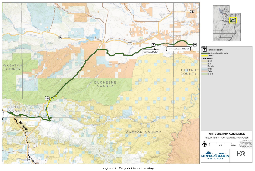
This map, included in U.S. Forest Service documents evaluating the Uinta Basin Railway proposal, shows the 88-mile length of the route. Tunnels are shown in yellow.
CREDIT: COURTESY IMAGE
The UBR track, with a right-of-way between 100 and 200 feet wide, would run mostly parallel to U.S. Highway 191, cutting through private property and agricultural fields in Indian Canyon before slicing through the Ashley National Forest. The railroad’s footprint would alter an estimated 167 acres within the IRA, with an additional 235 acres affected in the construction process but planned for reclamation. Three tunnels on Forest Service land, including two spiral tunnels and a portion of a 3-mile-long straight tunnel, would have a total length of 2.6 miles.
In a January interview for ChannelV6.com, a local broadcaster in northeast Utah, Kyle Robe, deputy project manager for Rio Grand Pacific, discussed the spiral tunnels planned for Indian Canyon and the 3-mile-long straight tunnel. “[We will] drill holes into the face of the rock and high-pressure grout those holes,” he said. Then come massive machines called “roadheaders.” “They’ve got a big arm and big rotors on the end with teeth on them [that] chip away at that rock,” said Robe. “We’ll get about 25 feet a day on each end of rock that we’ll tear out of the mountain.” Robe did not respond to interview requests from Aspen Journalism. A spokesperson for the Seven County Infrastructure Coalition also declined to comment, citing pending litigation.
Track construction also means carving out miles of cuts, siding track and embankment fill, and placing culverts and other infrastructure, including five bridges. Temporary work areas, including camps to house workers, could be up to 1,000 feet wide. Once completed, up to 10 trains per day would rumble through the IRA, each hauling up to 100 tanker cars of crude.
Darrell Fordham stands near a tunnel entrance for the proposed Uinta Basin Railway, which would pass near his family’s mountain retreat in Argyle Canyon, Utah.
CREDIT: AMY HADDEN MARSH/ASPEN JOURNALISM
CBD attorney Wendy Park pointed to a bigger, overarching issue. “Under [President Joe] Biden’s 2021 executive order, combating climate change is something that all federal agencies should be doing everything in their power to address,” she told Aspen Journalism. In his 2021 letter to CBD, Moore cherry-picked components of the executive order to support the touted economic benefits of the project, stating that the UBR would support Biden’s policy to build a sustainable economy. But Biden’s order states that the United States will develop a finance plan to promote “the flow of capital toward climate-aligned investments and away from high-carbon investments.”
Eickhoff, of the Ashley National Forest, also amended the 1986 Ashley National Forest Land Resource Management Plan (LRMP) to allow for the UBR corridor through the IRA. The LRMP calls for maintaining the area’s scenic values. But Eickhoff’s amendment exempts the UBR right of way.
The SCIC must meet conditions of the Forest Service approval, including federal and LRMP mitigation measures, before track construction can begin. But despite approving the UBR last summer, the Forest Service has yet to issue the actual permit.
The agency could still change course, which is what activists in Utah, Colorado and points east are hoping for. Protests last week in Boulder, Denver, Salt Lake City and Glenwood Springs called on U.S. Secretary of Agriculture Tom Vilsack to revoke the permit. “It’s worthwhile to continue to put pressure on the Biden administration and Secretary Vilsack because this project is a carbon bomb,” said CBD campaigner Deeda Seed. “This is a poster child for the harm from climate change.”
This story ran in the Glenwood Springs Post Independent on Dec. 13.