#ColoradoRiver States Submit a Consensus-Based Modeling Alternative to Bureau of Reclamation: Six states reach consensus on criteria for environmental review to help protect #LakePowell and #LakeMead #COriver #aridification

Click the link to read the article on the Arizona Department of Water Resources website:

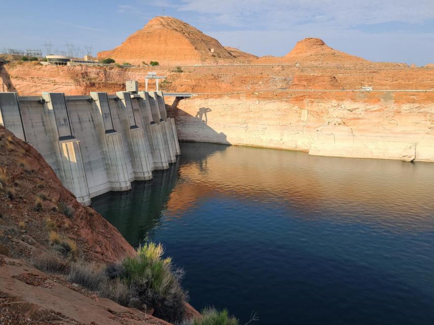
January 30, 2023 – Today, states sharing the Colorado River submitted a letter to the Bureau of Reclamation (Reclamation) that outlines a Consensus-Based Modeling Alternative for Reclamation to evaluate and incorporate into its development of a Supplemental Environmental Impact Statement (SEIS) to revise current Operating Guidelines (’07 Guidelines) for Glen Canyon Dam at Lake Powell and Hoover Dam at Lake Mead.

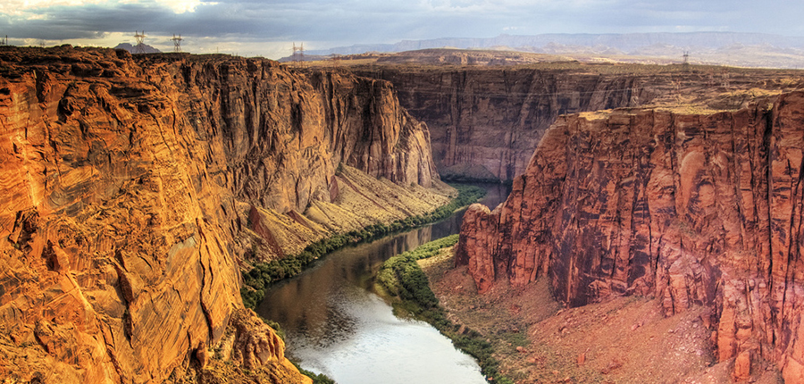
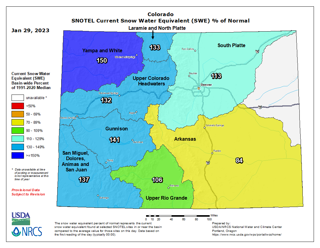
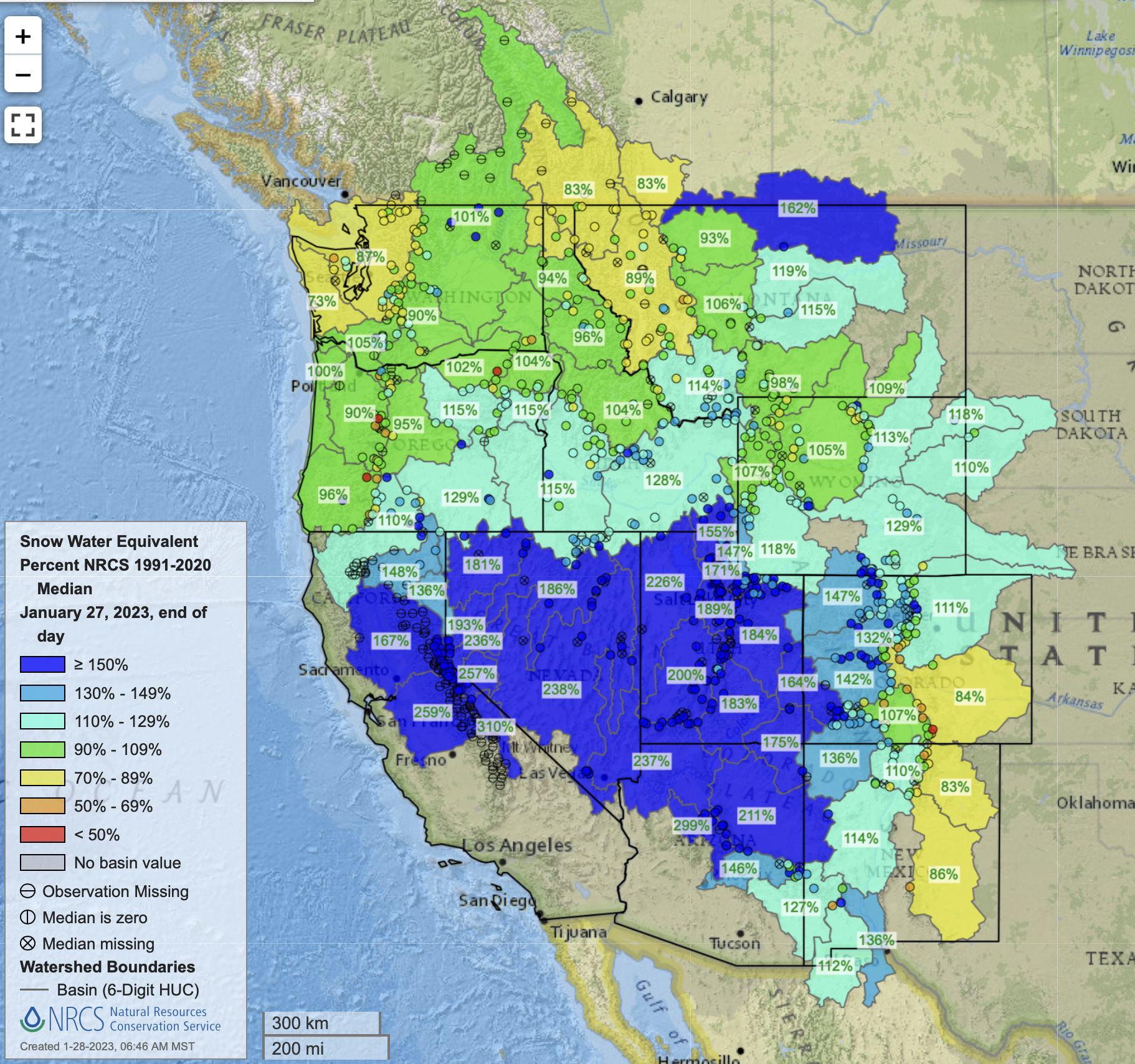
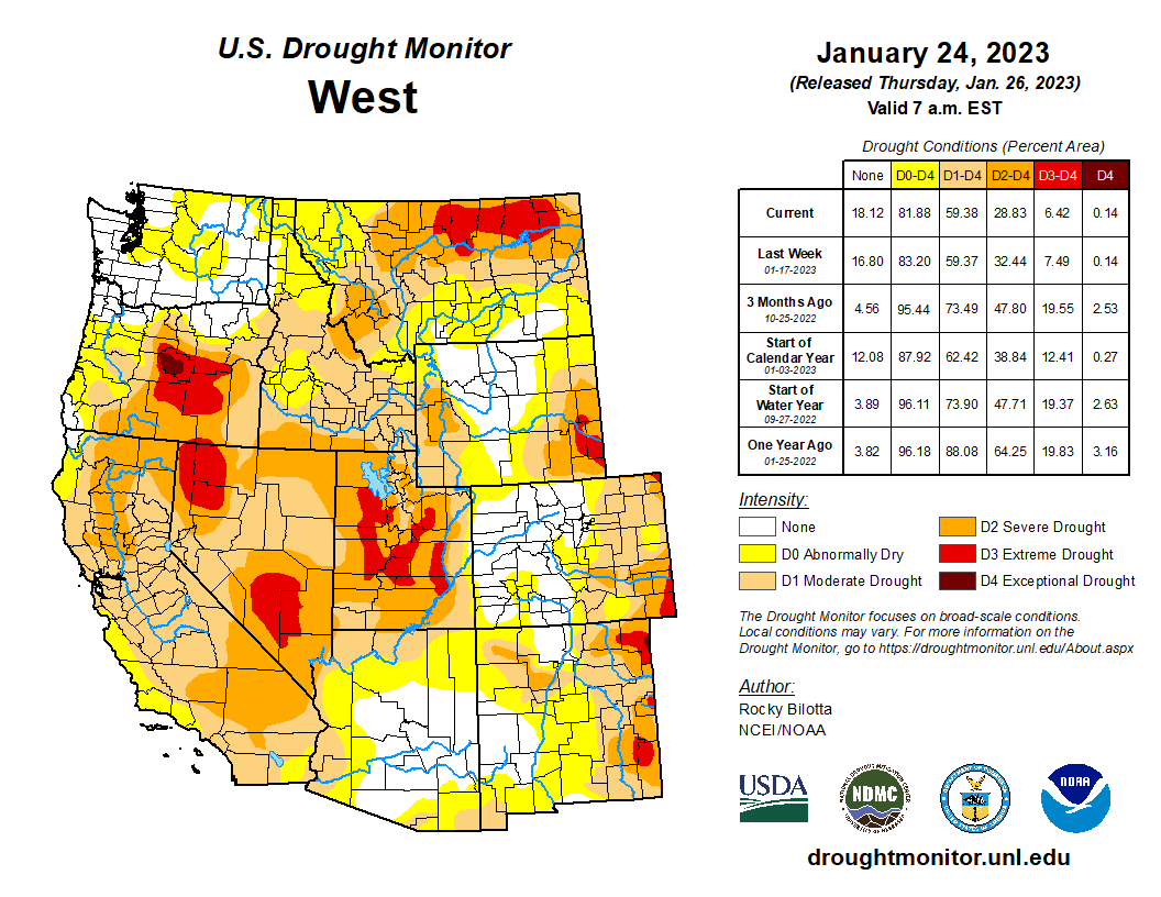
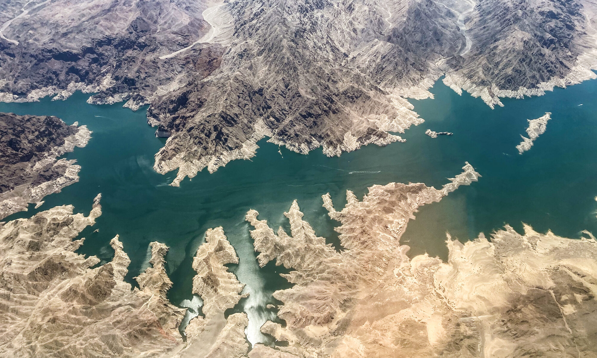
Revisions to the ’07 Guidelines are necessary to protect critical elevations and infrastructure within the two reservoirs to ensure the Colorado River system – which has been significantly impacted by more than two decades of prolonged drought exacerbated by clime change and depleted storage – can continue to serve more than 40 million people, approximately 5.5 million acres of irrigated farmland, Basin Tribes, environmental resources, and power production across seven states and portions of Mexico.

The states of Arizona, Colorado, Nevada, New Mexico, Utah and Wyoming jointly submitted the Consensus-Based Modeling Alternative, and the states remain committed to working cooperatively with their local water users, the federal government, other Basin States, Basin Tribes, non-governmental organizations and stakeholders throughout Reclamation’s environmental review and in accordance with the National Environmental Policy Act (NEPA).

While the Consensus-Based Modeling Alternative is not a formal agreement between the Colorado River Basin States, it serves as an alternative framework for Reclamation to analyze in its SEIS process. It provides an approach to help protect Glen Canyon Dam and Hoover Dam infrastructure, water deliveries, and power production to mitigate the risk of either Lake Powell or Lake Mead reaching dead pool.

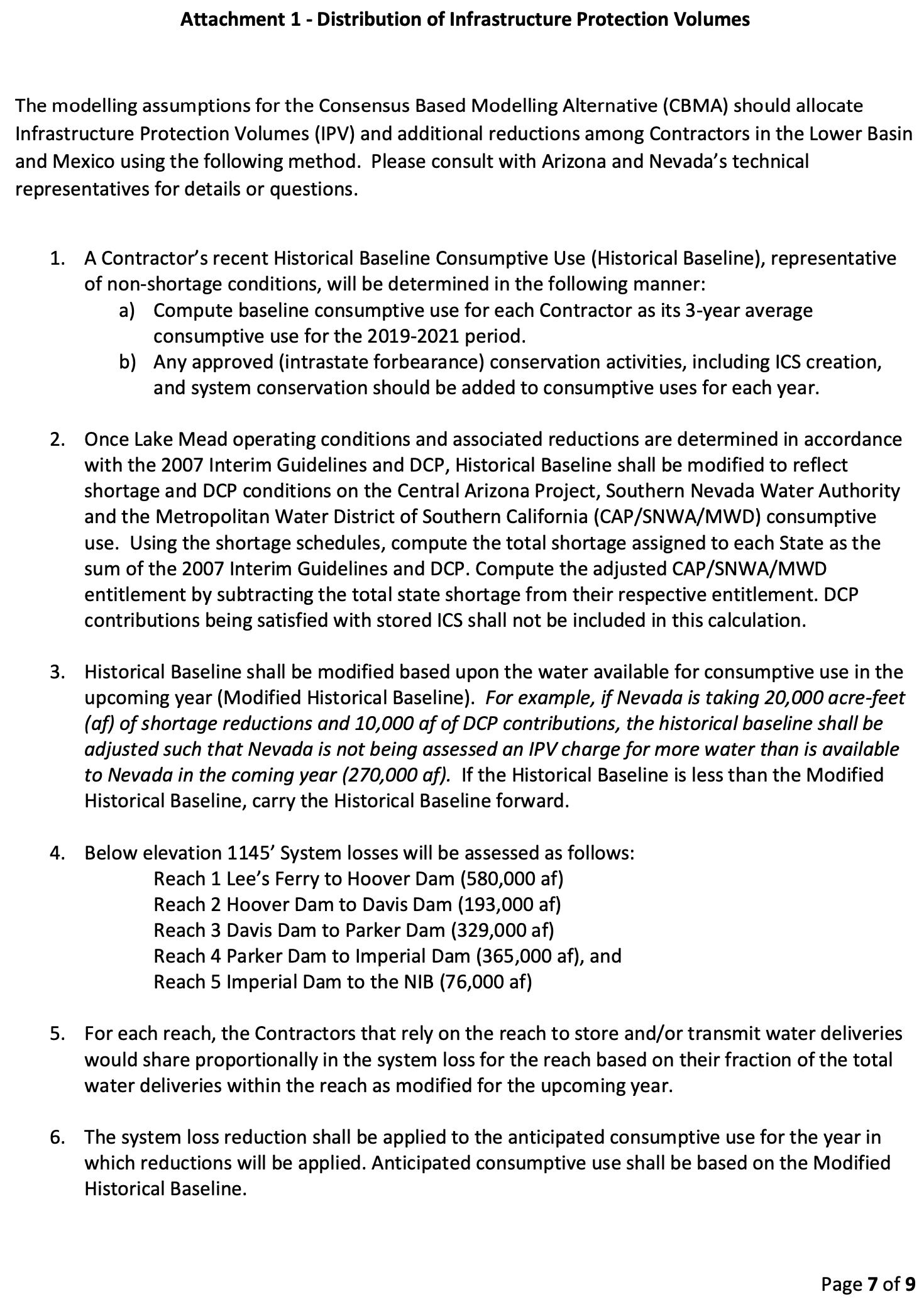
The Consensus-Based Modeling Alternative includes, but is not limited to, the following modeling criteria for Reclamation to consider and analyze:

  • Adjustments to the existing ‘07 Guidelines, including reduced releases from Lake Powell and Lake Mead to ensure the deliverability of water downstream and power production.
  • Adjustments to Lower Basin contributions required under Drought Contingency Plan.
  • Accounting for more than 1.5 million acre-feet of losses within the Lower Basin that arenecessary to protect infrastructure.
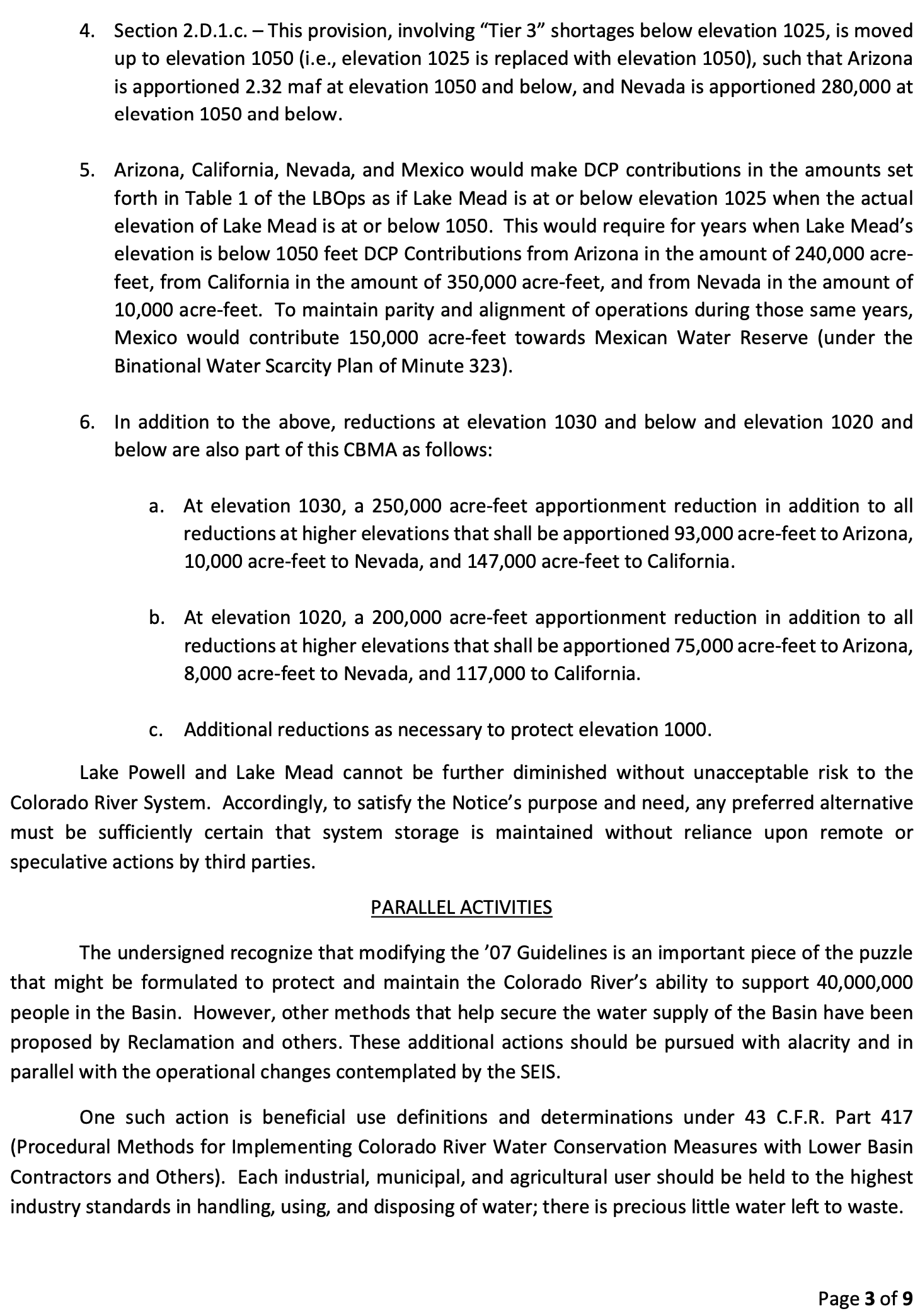
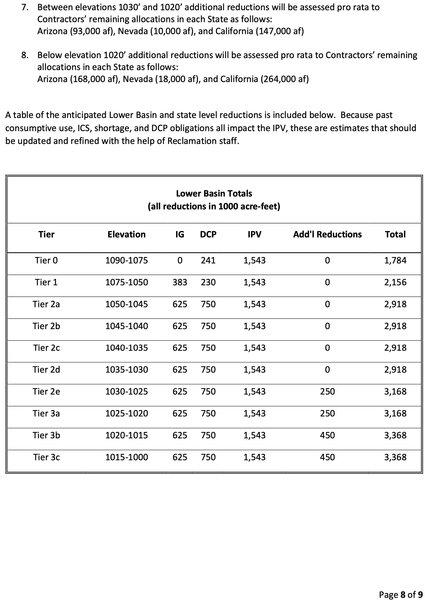
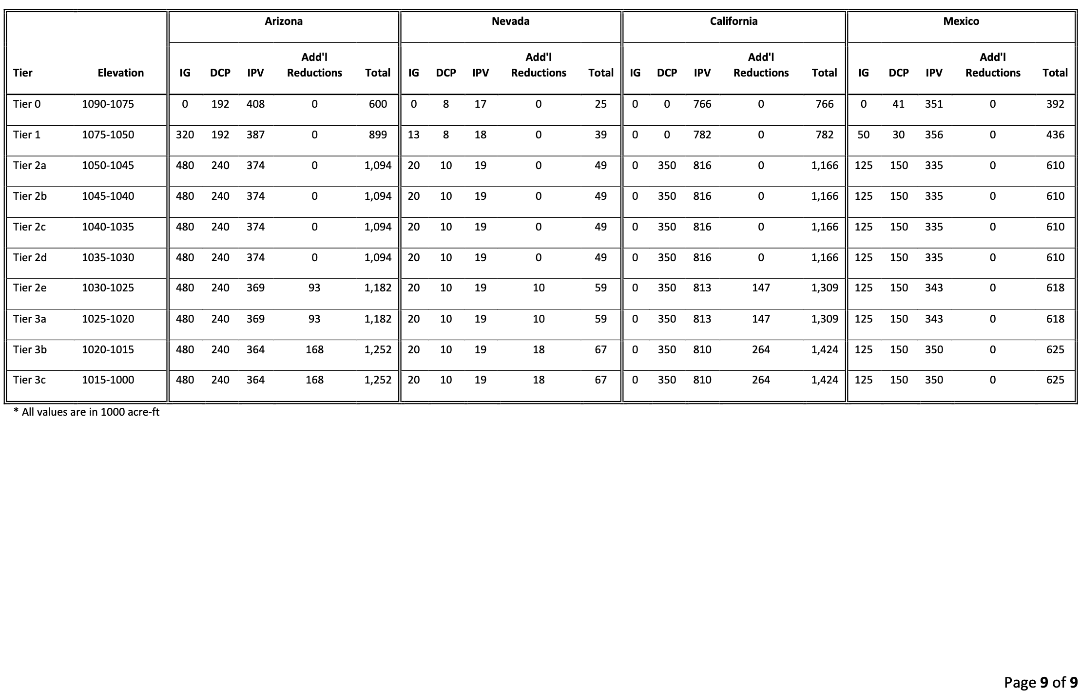
  • Additional combined reductions of 250,000 acre-feet to Arizona, California and Nevada at LakeMead elevation 1,030 feet and below.
  • Additional combined reductions of 200,000 acre-feet to Arizona, California and Nevada at LakeMead elevation 1,020 feet and below, as well as additional reductions necessary to protect LakeMead elevation 1,000 feet.
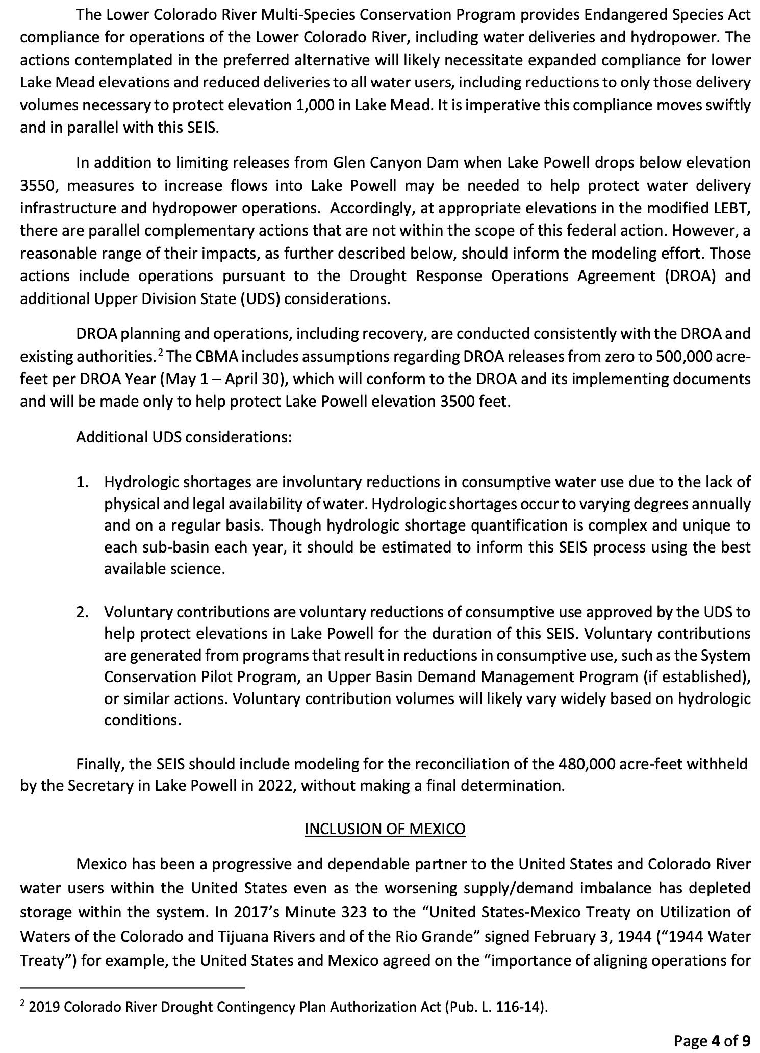
  • Actions outlined within the Upper Basin State’s Drought Response Operations Agreement.
  • Additional voluntary conservation measures that take into account hydrologic shortage in theUpper Division States.

“This modeling proposal is a key step in the ongoing dialogue among the Seven Basin States as we continue to seek a collaborative solution to stabilize the Colorado River system,” said Tom Buschatzke, Director of the Arizona Department of Water Resources.

“The CBMA includes the significant and necessary step of assessing evaporation and transit losses against Lower Basin uses. The Lower Basin actions operate in coordination with additional actions in the Upper Basin. We can only save the Colorado River system if we act together. The CBMA approach appropriately distributes the burden across the Basin and provides safeguards for the Tribes, water users, and environmental values in the Upper Basin,” said Becky Mitchell, Colorado Commissioner, Upper Colorado River Commission and Director Colorado Water Conservation Board of the Colorado River Department of Natural Resources.

“The CBMA is a vital step forward as Reclamation considers new additional actions to operate the Colorado River system for the next few years. We recognize that the process to prepare a proposal in such a short timeframe was imperfect. We need to continue discussions among all 7 Basin States and to engage directly with tribal leaders and others as we prepare to move forward with the components of the CBMA across the Upper and Lower Basin. We have much more to do, but the CBMA is a tremendous step in the right direction.” said Estevan Lopez, New Mexico Colorado River Commissioner.

“The challenge we continue to face is dry hydrology and depleted storage across the Colorado River Basin. The CBMA provides a path forward so that every state can contribute to finding a solution in close collaboration with our Tribes and water users,” said Gene Shawcroft P.E, Utah Colorado River Commissioner.

“The concepts identified in the CBMA are a significant step toward building the consensus necessary to take incredibly challenging but vital actions to address the crisis on the River. We look forward to continuing to work with all the States to build on the CBMA concepts and move forward together,” said Brandon Gebhart, Wyoming State Engineer.

A copy of the Consensus-Based Modeling Alternative is linked here.

Media Contacts:
Arizona Department of Water Resources:

Douglas MacEachern, dmaceachern@azwater.gov, 602-771-8507

Colorado Department of Natural Resources

Chris Arend, chris.arend@state.co.us, 303-264-8615

Southern Nevada Water Authority

Bronson Mack, bronson.mack@snwa.com, 702-822-8543

New Mexico State Engineer’s Office

Maggie Fitzgerald, maggie.fitzgerald@ose.nm.gov, 505-231-7822

Colorado River Authority of Utah

Marty Carpenter, mcarpenter@northboundstrategy.com, 801-971-3601

Wyoming State Engineer’s Office

Brandon Gebhart, brandon.gebhart1@wyo.gov

Upper Colorado River Commission

Alyx Richards, arichards@ucrcommission.com, 801-531-1150

Notice of Intent to Prepare a Supplemental Environmental Impact Statement — #ColoradoRiver Basin State Representatives of #Arizona, #Colorado, #Nevada, #NewMexico, #Utah, and #Wyoming #COriver #aridification

Colorado River “Beginnings”. Photo: Brent Gardner-Smith/Aspen Journalism

Federal pressure mounts as states attempt to break #ColoradoRiver standoff — KUNC #COriver #aridification

Hoover Dam’s intake towers protrude from the surface of Lake Mead near Las Vegas, where water levels have dropped to record lows amid a 22-year drought. (Source: Bureau of Reclamation)

Click the link to read the article on the KUNC website (Alex Hager). Here’s an excerpt:

The federal government has asked them to weigh in on tweaks to how the river is managed, and could force water cutbacks if states can’t come up with their own plan to reduce demand before February. That’s no small task for states deadlocked in a years-long standoff over how to cut back demand on a river that supplies 40 million people and a multibillion-dollar agricultural sector. Each of those states — Colorado, Wyoming, New Mexico, Utah, Arizona, Nevada and California — each bring a varied set of interests and motivations to the negotiating table to ensure any cutbacks don’t hit them harder than the rest…The Bureau of Reclamation will investigate plans for future releases regardless of whether the states agree on their own plan for cutbacks, and says the states “imposed an unofficial deadline on themselves for January 31, 2023, to ensure that their ideas were included in the draft SEIS process.”

“The notion of a certain date for states to submit their plans was the result of the states’ own recognition of the timing constraints of the supplemental process,” wrote Tyler Cherry, a Department of Interior spokesperson, in an email to KUNC. “States’ contributions to the process began during the scoping period and will continue throughout the comment period.”

[…]

The federal government may reduce releases from Glen Canyon Dam (pictured above) in 2023 by an unprecedented 2-3 million acre-feet, a move that would trigger severe cuts in the Lower Basin. (Source: Bureau of Reclamation)

Sources tell KUNC that delegates from the seven states have met in Colorado in recent days to hash out a deal, but the details of that meeting have been kept behind closed doors, and experts don’t see an obvious outcome. Negotiations are difficult — and have been for decades — because of the river’s diverse user base and complex, multi-layered governance system. While the river supplies major cities such as Denver, Las Vegas, Phoenix and Los Angeles, 80% of its water is used for agriculture. Farmers in southern California have some of the oldest, and most protected water rights in the Colorado River Basin.

“What you’re talking about are people’s livelihoods and farmers’ livelihoods,” said John Berggren, a water policy analyst at the conservation group Western Resource Advocates. “If you’re an irrigator or a rancher or a farmer, your water is your most important asset.”

Deadpool Diaries: Can the #ColoradoRiver community walk, chew gum, and recite Homer’s Odyssey at the same time? — John Fleck @jfleck #COriver #aridification

The Colorado River Stress test, a Homeric odyssey

Click the link to read the article on the InkStain website (John Fleck):

While we eagerly await whatever it is that might happen this week as the Colorado River basin states struggle to come up with a short term plan to use less water…

It’s a crazy time, and I worry about our collective capacity, but the river can’t wait, so buckle up!

A brief refresher is perhaps in order

THE SUPPLEMENTAL EIS

I emerged from the writing cave (new book underway about the Rio Grande, which is a mostly a different river entirely) to share my thoughts about this week’s “deadline” (which as I explained isn’t really a “deadline”) for the seven Colorado River basin states to come up with a plan for managing the river for the next several years. This is a short-term effort, an attempt to limp through the 2025-26 time frame without breaking things. It requires temporary rules to reduce water use as needed in the Lower Basin, maybe some water use reductions in the Upper Basin, and tweaks to the reservoir operations rules to keep from breaking Glen Canyon Dam.

“EIS” here stands for “Environmental Impact Statement”, the process by which Reclamation will analyze our choices before picking one.

The key words here are short term.

THE REAL EIS

Post-2026, we need a much more robust and long-lasting framework for using less water and not breaking the dams and trying to respect tribal sovereignty and our evolving societal values around respect for the environment in the face of climate change stealing a bunch of our water.

In that regard, Reclamation has launched an expansive effort to help us collectively, as a society, think through these options.

A bunch of us wrote them letters last year telling them what we thought they should think about. They’ve summarized them nicely (pdf here). My favorite part is the people from Costa Rica and the UK who weighed in. This is a far-reaching issue.

THE CONNECTION BETWEEN THE SUPPLEMENTAL EIS AND THE REAL EIS

One of the difficulties in sorting out the near-term plans is that everyone’s angling for the high ground in the long-term plans. There’s a fear among water managers that if in the short term they demonstrate that they’re able to get by with less water, they’ll get screwed long term. A lot of what we figure out in the short term will echo into the long term.

HOMER’S ODYSSEY

In season one of the Simpson’s, there’s a great episode called “Homer’s Odyssey” where Homer Simpson gets fired from the nuclear power plant and then becomes a citizen safety advocate who gets speed bumps and stop signs installed in Springfield, and Homer becomes a revered community leader, and Mr. Burns hires him back to become the chief safety officer at the nuclear power plant.

You didn’t think I meant reciting the entire Homeric epic, did you? I fear one episode of the Simpsons is the most we can hope for right now.

Picture courtesy Eric Kuhn’s 2013 presentation at the Colorado River Water Users Association.

In the West, pressure to count #water lost to evaporation — The Associated Press #ColoradoRiver #COriver #aridification

Colorado River. Photo credit: University of Montana

Click the link to read the article on the Associated Press website (Suman Naishadham). Here’s an excerpt:

 Exposed to the beating sun and hot dry air, more than 10% of the water carried by the Colorado River evaporates, leaks or spills as the 1,450-mile (2,334-kilometer) powerhouse of the West flows through the region’s dams, reservoirs and open-air canals. For decades, key stewards of the river have ignored the massive water loss, instead allocating Arizona, California, Nevada and Mexico their share of the river without subtracting what’s evaporated. But the 10% can no longer be ignored, hydrologists, state officials and other western water experts say…

The challenge is in finding a method that California also agrees to…

Unlike Arizona, California, Nevada and Mexico, the upriver or Upper Basin states — Colorado, New Mexico, Utah, and Wyoming — already take into account evaporation losses…

One proposal comes from Nevada: States at the end of the river would see their Colorado River portion shrink based on the distance it travels to reach users. The farther south the river travels, the more water is lost as temperatures rise and water is exposed to the elements for longer.  The Southern Nevada Water Authority estimates that roughly 1.5 million acre-feet of water are lost to evaporation, transportation and inefficiencies each year in Arizona, Nevada and California. That’s 50% more than Utah uses in a whole year.

#Colorado should kick lawns to the curb: The billions of gallons of fresh #water that goes to grass is an egregious misuse of resources — #Colorado Newsline

Thornton home and lawn 2019. Photo credit: Brent Gardner-Smith/Aspen Journalism

Click the link to read the opinion piece on the Colorado Newsline website (Sammy Herdman):

Over the course of the next seven years, an average 35,000 housing units will be built each year in Colorado. If past trends persist, around 70% of those housing units will be single-family homes. From Fort Collins to Colorado Springs, it’s likely that Coloradans will see more single-family suburban developments popping up — and with them, lawns.

Conventional grass lawns ornament the vast majority of American homes, covering three times as much surface area as irrigated cornfields in the United States. Although lawns are often purely aesthetic, sometimes they are chosen for their durability; lawns hold up against cleats, dogs and kids. Lawns used frequently for games and playtime are easy to justify, especially when they are public.

But there are far too many cropped, green lawns that are neglected until a weed sprouts up or it’s time to mow. Too many lawns exist just for the sake of being maintained.

Despite covering 2% of land in the U.S., most grasses can’t survive in the West’s arid climate without constant watering. In Denver, about half of the water used by the average single-family home is devoted to lawn care. Combined with the water sprinkled onto parks, medians and golf courses, a whopping 25% of Denver’s municipal water is devoted to lawns.

Considering that the Western U.S. is in the midst of the most severe drought in a millennium, allocating billions of gallons of fresh water to grass seems like an egregious misuse of resources. The drought is so dire that the Colorado River, which provides 40 million people across the Western U.S. with water, has shrunk by 20% over the past 20 years.

Native solitary bee. Photo: The Xerces Society / Rich Hatfield

Lawn maintenance is also a threat to Colorado’s pollinators and public health. Americans use approximately 70 million pounds of pesticides to maintain lawns each year. Of the 30 most common lawn pesticides, more than half are probable or possible carcinogens, and many of them are linked with birth defects, neurotoxicity, kidney damage, liver damage and more.

In Colorado cities and towns, such as Colorado Springs, the glyphosate-based herbicide known as Roundup is sprayed on lawns in public parks, despite being a possible carcinogen. Lawn pesticides and fertilizers commonly run off into lakes, streams and groundwater, wreaking havoc on aquatic ecosystems and polluting drinking water. Pollinators, which are on the decline globally and in Colorado, are harmed when lawn pesticides contain neonicotinoid chemicals. Insecticides aimed at lawn pests don’t spare bees and butterflies.

Lawn equipment also contributes to the climate crisis and the Front Range’s bad air quality. According to the EPA, in just one year, gas-powered lawn and garden equipment produced more than 20 million tons of U.S. carbon dioxide emissions. Even more emissions are created when lawn clippings are disposed of in landfills. In the Front Range, gas-powered lawn and garden equipment contribute as much as one-fifth of the region’s ozone pollution.

Landscaping alternatives better suited to Colorado do exist. Replacing lawns with drought-tolerant landscaping — termed xeriscaping by Denver Water — can reduce water usage by 30-80%. Replacing lawns with native plants can reduce the need for pesticides and fertilizers. Growing native plants also patches together habitat for dwindling pollinator populations.

Colorado is a state defined by mountainous vistas, natural landscapes and abundant wildlife. Its residents are outdoor enthusiasts and free-thinkers, demonstrably not afraid to break the mold (consider the legalization of marijuana, the decriminalization of psychedelics). Yet many of Colorado’s yards exhibit a custom justified primarily by tradition and peer pressure.

Some cities, such as Aurora and Castle Rock, have passed ordinances to limit new lawns. However, statewide and in Denver, little to no progress has been made to incentivize xeriscaping.

Lawns are antithetical to the climate and character of Colorado. Colorado’s leaders should implement educational programs about alternative landscaping and introduce greater financial incentives for home-owners and developers to replace lawns.

As our state enters another year of drought, climate chaos and habitat loss, hopefully Colorado will kick lawns to the curb.

#Snowpack news January 30, 2023

West snowpack basin-filled map January 29, 2023 via the NRCS.
Colorado snowpack basin-filled map January 29, 2023 via the NRCS.

Associated Press Exclusive: Emails reveal tensions in #ColoradoRiver talks #COriver #aridification

Lake Mead shipwreck. Photo credit: John Fleck

Click the link to read the article on the Associated Press website (Kathleen Ronayne and Felicia Fonseca). Here’s an excerpt:

Competing priorities, outsized demands and the federal government’s retreat from a threatened deadline stymied a deal last summer on how to drastically reduce water use from the parched Colorado River, emails obtained by The Associated Press show…

“We are out of time and out of any cushion to allow for a voluntary plan,” Tom Buschatzke, director of the Arizona Department of Water Resources, told a Bureau of Reclamation official in a July 18 email…

As 2023 begins, fresh incentives make the states more likely to give up water. The federal government has put up $4 billion for drought relief, and Colorado River users have submitted proposals to get some of that money through actions like leaving fields unplanted. Some cities are ripping up thirsty decorative grass, and tribes and major water agencieshave left some water in key reservoirs — either voluntarily or by mandate. Reclamation also has agreed to spend $250 million mitigating hazards at a drying California lake bed, a condition of the state’s water users agreeing to cut their use by 400,000 acre feet in a proposal released in October. The Interior Department is still evaluating proposals for a slice of the $4 billion and can’t say how much savings it will generate, Deputy Secretary Tommy Beaudreau said in an interview…

Figuring out who absorbs additional water cuts has been contentious, with allegations of drought profiteering, reneging on commitments, too many negotiators in the room and an unsteady hand from the federal government, the emails and follow-up interviews showed. California says it’s a partner willing to sacrifice, but other states see it as a reluctant participant clinging to a water priority system where it ranks near the top. Arizona and Nevada have long felt they’re unfairly forced to bear the brunt of cuts because of a water rights system developed long ago, a simmering frustration that reared its head during talks…But state officials said when it became clear the federal government wouldn’t act unilaterally, it created a “chilling effect” that removed the urgency from the talks because water users with higher-priority water rights were no longer at risk of harsh cuts, Arizona’s Buschatzke said in an interview…

Reclamation is now focused on weighing the latest round of comments from states on how to save the river. Nevada wants to count water lost to evaporation and transportation in water allocations — a move that could mean the biggest volume of cuts for California — and some Arizona water managers agree, comment letters obtained by the AP show.  But disputes remain over how to determine what level of cuts are fair and legal. California’s goal remains protecting its status while other states and tribes want more than old water rights taken into account — such as whether users have access to other water sources, and the effects of cuts on disadvantaged communities and food security. Reclamation’s goal is to get a draft of proposed cuts out by early March, then a final decision before mid-August, when Reclamation regularly announces how much — or how little — river water is available for the next year.

Map credit: AGU

What’s Up With #Water – January 17, 2023 — Circle of Blue @circleofblue

Shasta Dam, north of Redding in California, is the only dam in the state a UC Davis study identified as being capable of replicating natural cold-water patterns for aquatic species. (Ron Lute/cc BY-NC 2.0)

Click the link to listen to the podcast on the Circle of Blue website (Eileen Wray-McCann):

A new report says that the world’s dams are filling up – but not in a good way. Rivers are depositing sediment into the reservoirs behind dams, reducing their capacity to hold water. Researchers affiliated with the United Nations calculated how much storage might be lost in the next three decades at the world’s 50,000 large dams. The report estimates that a quarter of the original water storage capacity will be lost by 2050 because of sediment buildup. This will hurt irrigation, power generation, and flood protection. The largest loss of storage capacity will occur in the United Kingdom, Panama, Ireland, and Japan, with the U.S, not far behind.

Arizona Rivers Map via Geology.com.

In Arizona, newly elected leaders wasted no time in tackling the state’s urgent water problems. Katie Hobbs was sworn in as governor on January 2 and began her term by calling water issues “the challenge of our time.” After a week in office, Hobbs established an expert council to recommend updates to the state’s groundwater laws. She also unveiled a previously unreleased report from the Arizona Department of Water Resources. Hobbs’s predecessor had withheld the report from the public. It shows that a high-growth area west of Phoenix does not have enough groundwater to sustain a planned mega-development of 100,000 homes. According to the Arizona Republic, homebuilders must now find other water supplies to finish the development. Hobbs said the area’s inadequate groundwater should be a wake-up call. She said “This report unequivocally shows that we have to act now, or this will only be the first new area that faces this kind of shortage.” Meanwhile, Arizona’s new attorney general hopes to undo a farming deal with a Saudi Arabian company that’s adding to local groundwater declines. Kris Mayes campaigned on a promise to repeal a land lease that the state made with Fondomonte. The firm got below-market rates, leasing 10,000 acres in western Arizona to grow alfalfa for export to Saudi Arabia as cattle feed. Residents in the area have seen their wells run dry as the farm pumps groundwater to irrigate the alfalfa.

Photo credit: Kim Delker/University of New Mexico

In New Mexico, some communities could get millions to rebuild their water systems after the largest wildfire in state history tore through their watershed last year. The funds are a lifeline for areas ravaged by a drying climate. They also underscore the financial and ecological vulnerability of small, impoverished communities in the face of extreme weather. In the this year’s budget, Congress allocated nearly one and a half billion dollars for post-fire recovery in New Mexico. That’s in addition to the two and a half billion dollars that lawmakers had already directed to the state, bringing the total amount of federal aid after the Hermit’s Peak/Calf Canyon fire to nearly $4 billion. The year-end appropriations package included a line item of particular significance: $140 million for water treatment systems for communities in the area scarred by the fire. That includes the small town of Las Vegas, just 12 miles from where the fire started. Las Vegas has about 13,000 people. What is does not have is high-quality water. The town’s main water source, the Gallinas River, is surrounded by scars from the Hermit’s Peak/Calf Canyon fire. The fire ignited in April, after a prescribed burn by the U.S. Forest Service grew out of control. The fire was the largest on record in New Mexico, burning well over 300 thousand acres of public and private land. The Gallinas River used to be a clear stream, but is now is laden with sediment and suspended solids due to ash and soil erosion. That’s a serious problem for the water treatment operators in Las Vegas, according to the town utility director, Maria Gilvarry. The fire did not destroy the treatment system, but the effects of the fire have overwhelmed it. It’s not uncommon for the river water it’s processing to measure a hundred times murkier than before the fire. The current treatment system struggles under those conditions. Until a new treatment system is in place, the utility department is making do with temporary equipment to remove sediment. It is also re-calibrating the chemicals to purify drinking water so that the treatment process is more effective. Gilvarry said federal aid is an undeniable blessing for a predominantly Latino city where median household income is just over $34,000 — about half the national figure. The poverty rate in Las Vegas, New Mexico is above 30 percent. Gilvarry said that Federal aid is the only way the town’s water treatment project could advance so swiftly. As she put it: “Not on our own dime. This is a low-income community.”

As the #ColoradoRiver Shrinks, Washington Prepares to Spread the Pain — The New York Times #COriver #aridification

Water users are urgently trying to keep Lake Powell on the Utah-Arizona border from dropping to a point where Glen Canyon Dam can no longer generate electricity. (Source: Bureau of Reclamation)

Click the link to read the article on The New York Times website (Christopher Flavelle). Here’s an excerpt:

“Think of the Colorado River Basin as a slow-motion disaster,” said Kevin Moran, who directs state and federal water policy advocacy at the Environmental Defense Fund. “We’re really at a moment of reckoning.”

Negotiators say the odds of a voluntary agreement appear slim. It would be the second time in six months that the Colorado River states, which also include Colorado, New Mexico, Utah and Wyoming, have missed a deadline for consensus on cuts sought by the Biden administration to avoid a catastrophic failure of the river system. Without a deal, the Interior Department, which manages flows on the river, must impose the cuts. That would break from the century-long tradition of states determining how to share the river’s water. And it would all but ensure that the administration’s increasingly urgent efforts to save the Colorado get caught up in lengthy legal challenges. The crisis over the Colorado River is the latest example of how climate change is overwhelming the foundations of American life — not only physical infrastructure, like dams and reservoirs, but also the legal underpinnings that have made those systems work.

A century’s worth of laws, which assign different priorities to Colorado River users based on how long they’ve used the water, is facing off against a competing philosophy that says, as the climate changes, water cuts should be apportioned based on what’s practical. The outcome of that dispute will shape the future of the southwestern United States.

“We’re using more water than nature is going to provide,” said Eric Kuhn, who worked on previous water agreements as general manager for the Colorado River Water Conservation District. “Someone is going to have to cut back very significantly.”

The rules that determine who gets water from the Colorado River, and how much, were always based, to a degree, on magical thinking…But the premise that the river’s flow would average 17.5 million acre-feet each year turned out to be faulty. Over the past century, the river’s actual flow has averaged less than 15 million acre-feet each year. For decades, that gap was obscured by the fact that some of the river’s users, including Arizona and some Native American tribes, lacked the canals and other infrastructure to employ their full allotment. But as that infrastructure increased, so did the demand on the river. Then, the drought hit. From 2000 through 2022, the river’s annual flow averaged just over 12 million acre-feet; in each of the past three years, the total flow was less than 10 million.

Updated Colorado River 4-Panel plot thru Water Year 2022 showing reservoirs, flows, temperatures and precipitation. All trends are in the wrong direction. Since original 2017 plot, conditions have deteriorated significantly. Brad Udall via Twitter: https://twitter.com/bradudall/status/1593316262041436160

San Luis Valley counties band together to fight #water exportation — @AlamosaCitizen #RioGrande

Click the link to read the article on the Alamosa Citizen website (Chris Lopez):

SOMETIMES playing defense can be your most effective offense.

Anticipating another eventual push to export water from the San Luis Valley aquifers and the headwaters of the Upper Rio Grande, officials in each of the six counties are drafting an intergovernmental agreement and specific planning regulations they hope will legally block any water exportation project.

Through an intergovernmental agreement, the counties would look to establish a “Joint Planning Area” to protect the Valley’s water resources and then adopt specific 1041 planning regulations that address protecting the Valley’s water resources from exportation.

EARLIER COVERAGE: The Water Archives

“This might be our best opportunity to stop water exportation,” said Saguache County Commissioner Tom McCracken, who chairs the San Luis Valley Regional Council of Governments board. “I’m feeling really excited about it.”

It’s through the San Luis Valley Regional Council of Governments that county officials and city officials have been meeting to draft the intergovernmental agreement and eventually establish 1041 regulations specifically around water exportation proposals. Any proposal that would aim to take water out of the Valley, such as the Renewable Water Resources plan, would have to satisfy all the regulations in applying for the required county permits.

The city of Alamosa and the city of Monte Vista are expressing interest in being part of the water resources intergovernmental agreement as well.

In a speech last April where he addressed the RWR plan, Colorado Attorney General Phil Weiser encouraged the use of 1041 regulations so that communities have a “seat at the table in shaping the water projects that impact them.”

“Broadly speaking, a local government can use its 1041 powers to limit the negative impacts associated with the development of certain ‘areas’ or ‘activities of state interest.’ Such areas or activities might be related to everything from water infrastructure to buy-and-dry projects. Overall, these powers are intended to allow local governments to protect our lands, their value, and their use,” Weiser said.

CONVERSATIONS among county commissioners began in earnest early last summer following interest by Douglas County in the Renewable Water Resources proposal to pump 20,000 acre-feet every year out of the Valley to the Front Range bedroom community.

A visit by Douglas County Commissioner Abe Laydon last year to talk to RWR supporters in the San Luis Valley heightened concerns among county commissioners. Following Laydon’s visit, local county commissioners began conversations on how to counter both Douglas County’s interest and the ongoing efforts by Renewable Water Resources to export water from the Valley.

“I do still see a need and I feel good about the movement that’s been made,” said Alamosa County Commissioner Vern Heersink, who has been involved in the discussions from the beginning.

“I didn’t think we would have this much of a voice,” Heersink said, “and so it’s exciting to be working together with the other counties on a common goal.”

As headwater counties in the Upper Rio Grande Basin, there’s strength in numbers when it comes to battling water projects with smaller counties banding together to counter efforts by a large suburban county like Douglas County.

The Northwest Colorado Council of Governments offers a template to the approach in how that region battled the Two Forks project in the 1990s.

“The only way a region like the San Luis Valley can be successful and have a real say in the water world is if it bands together,” said attorney Barbara Green. Her law firm, Sullivan Green Seavy, is advising the San Luis Valley Regional Council of Governments in the drafting of the intergovernmental agreement. The agreement itself has no regulatory effect but simply forms the “Joint Planning Area,” Green explained to commissioners at a meeting last week in Alamosa.

It’s the 1041 regulations that provide the teeth.

THE strategy could also provide a checkmate to Douglas County’s own interest to get into the business of being a water provider, which it currently is not.

At a recent Douglas County Commissioner work session, Laydon raised the idea of creating a volunteer water commission, similar to a county planning commission, to help Douglas County plan forward on securing water for its future needs.

“We know that the state does not have a concrete water plan. I think that’s to come,” Laydon said. “In the west and certainly in Douglas County we know that water is a top priority issue, a scarce resource that we need to have some long-range, thoughtful planning around.

“I think we’re overdue in Douglas County to really activate a water commission and have a comprehensive plan much like we do in transportation and our comprehensive master plan in land use.”

Bill Owens, former Republican governor of Colorado and RWR pitchman, has been courting Douglas County to buy into Renewable Water Resources. Attorneys hired by Douglas County have outlined the significant legal and logistical hurdles to the RWR proposal.

Having each of the San Luis Valley’s six counties adopt specific planning regulations around water exportation and enter into intergovernmental agreements adds another layer of local regulation around water projects.

The effort is not so Valley counties can meddle in each other’s business, said Heersink, but a specific response to any plans for water exportation.

“We want to prevent a diversion that takes the water out of the Valley,” he said.

Potential Water Delivery Routes. Since this water will be exported from the San Luis Valley, the water will be fully reusable. In addition to being a renewable water supply, this is an important component of the RWR water supply and delivery plan. Reuse allows first-use water to be used to extinction, which means that this water, after first use, can be reused multiple times. Graphic credit: Renewable Water Resources

To help prevent out-of-control wildfires, US sends $930 million to western states — The Associated Press via #Colorado Public Radio

Sources/Usage: Public Domain. Post-wildfire flooding and debris flow in a small canyon above the Las Lomas debris basin in Duarte, the winter after the the June 2016 Fish Fire in Los Angeles County, California.

Click the link to read the article on the Colorado Public Radio website (The Associated Press/Matthew Brown). Here’s an excerpt:

The U.S. is directing $930 million toward reducing wildfire dangers in 10 western states by clearing trees and underbrush from national forests, the Biden administration announced Thursday, as officials struggle to protect communities from destructive infernos being made worse by climate change. Under a strategy now entering its second year, the U.S. Forest Service is trying to prevent out-of-control fires that start on public lands from raging through communities. But in an interview with The Associated Press, U.S. Agriculture Secretary Tom Vilsack acknowledged that the shortage of workers that has been plaguing other sectors of the economy is hindering the agency’s wildfire efforts…

The work is projected to cost up to $50 billion. Last year’s climate and infrastructure bills combined directed about $5 billion to the effort.

“There’s one big ‘if,’ ” Vilsack said. “We need to have a good partner in Congress.”

He added that fires on public lands will continue to threaten the West, after burning about 115,000 square miles (297,000 square kilometers) over the past decade — an area larger than Arizona — and destroying about 80,000 houses, businesses and other structures, according to government statistics and the nonpartisan research group Headwaters Economics.

Completion of High Line Canal Trail Colfax to I-70 to turn dirt starting January 30, 2023 — The City of #Aurora

High Line Canal Trail Project Overview Map. Credit: City of Aurora

Click the read about the projection on the City of Aurora website:

Construction Project Overview

The city of Aurora, in collaboration with American Civil Constructors, will start work Jan. 30 on a multi-use trail to close the gap along the High Line Canal between Colfax Avenue and recent improvements constructed north of I-70. 

The High Line Canal Trail construction project, which spans nearly two miles, will include:

  • A continuous 8-foot-wide concrete trail
  • Two pedestrian bridges (one to cross over the canal just south of Smith Road and one over I-70 just east of the Tower Road interchange)
  • An upgraded railroad crossing to promote pedestrian and cyclist safety
  • Access to the 71-mile High Line Canal Regional Trail within the metro area

Designed with community input, the new trail will provide close-to-home, accessible recreation opportunities within the community and serve a diverse population that may otherwise have limited opportunities to access natural areas. View additional details regarding the community input process, project files and more at EngageAurora.org/HLCT.

The city has been granted federal funds through the Denver Regional Council of Governments to help pay for the trail construction with city capital improvement funding used as a match amount. Additional funding partners consist of the Conservation Trust Fund, Adams County Open Space Grant, and the Adams County Open Space Tax Shareback.

Construction Updates

American Civil Constructors will begin work on the project’s south end and between East Colfax and East 19th avenues on the east side of Tower Road and along the canal.

Vehicular and pedestrian travelers can expect intermittent delays in these areas for the first two months. Alternate routes are recommended when possible.

The contractor also plans to start working on the bridge abutment just south of I-70 when the project kicks off.

Traffic impacts will be posted on this page as the project progresses.

Project Contact Information

Harlie Zehnder, JH Resources
720.460.0947 or highlinecanaltrail@gmail.com

Old cottonwoods line the banks and trails of the historic Highline Canal, which is being converted into an ultra modern stormwater system even as its trail systems continue to serve metro area residents. July 21, 2020 Credit: Jerd Smith via Water Education Colorado

Atmospheric rivers take a chunk out of #California #drought — NOAA

Click the link to read the article on the NOAA website:

A series of nine atmospheric rivers starting in late December 2022 through mid-January 2023 dropped feet of rain and snow across California and other parts of the West Coast, according to a special drought update from Drought.gov. The tremendous amounts of precipitation caused major transportation issues, as well as landslides and flooding, but it also led to drought improvements across a large chunk of the western United States.

Percent of normal U.S. precipitation over the past 30 days (December 25, 2022, through January 23, 2023) after a series of weather events known as atmospheric rivers, fueled by tropical moisture, flooded the U.S. West with rain and snow. Places where precipitation was less than 100 percent of the 1991-2020 average are brown; places where precipitation was 300 percent or more than average are blue-green. NOAA Climate.gov image, based on analysis and data provided by the Climate Mapper website.

In just three weeks, 80 percent of the average seasonal snowpack fell in California, with 11.2 inches of precipitation being observed on average for the entire state. Said another way, almost half (46%) of the average statewide water-year precipitation fell in just three weeks.

No landscape can handle this much precipitation in so short a time period. Flooding, mudslides, debris flows and dangerous travel conditions were the norm for California at the start of 2023. But in positive news, the heavy rains and snows increased soil moisture and snowpack, and filled many reservoirs that were quite below-average heading into this year.

This moisture resulted in widespread improvement in drought conditions out West, especially in California. But the drought isn’t over in many places, where long-term impacts to groundwater, reservoirs, and ecosystems persist despite the recent downpours. According to the Drought.gov, 92 percent of California was still in some level of drought based on data through January 17. (The next update will be tomorrow, January 26). Long-term drought also still persists in areas like the Colorado River Basin.

For more on the western drought, check out this special edition drought status updateissued by the National Integrated Drought Information System.

Read more on how NOAA monitors and predicts atmospheric rivers

Read more on how El Niño and La Niña affect atmospheric rivers.

The NOAA Atmospheric River Portal

BLM, nonprofit partner on land acquisition along #GunnisonRiver — The #GrandJunction Daily Sentinel

Map of the Gunnison River drainage basin in Colorado, USA. Made using public domain USGS data. By Shannon1 – Own work, CC BY-SA 4.0, https://commons.wikimedia.org/w/index.php?curid=69257550

Click the link to read the article on The Grand Junction Daily Sentinel website (Dennis Webb):

The Bureau of Land Management and a nonprofit entity have teamed up once again on an acquisition by the federal agency of land along the lower Gunnison River, this time involving a 26.32-acre parcel in Mesa County. The BLM’s Grand Junction Field Office partnered with the Western Rivers Conservancy on the acquisition of the Meridian Junction property, on the east side of the river just north of the Mesa/Delta county line. The acquisition furthers partnership efforts to conserve and protect resources for future generations, the agency said in a news release. The land is within the Dominguez-Escalante National Conservation Area, and was bought with money from the federal Land and Water Conservation Fund.

Suncor polluted #SandCreek with excessive levels of #benzene after Christmas Eve fire — The #Denver Post

Suncor refinery Commerce City. Photo credit: Allen Best/Big Pivots

Click the link to read the article on The Denver Post website (Noelle Phillips). Here’s an excerpt:

Suncor filed a notice with the Colorado Department of Public Health and Environment to notify the state of the benzene discharge into Sand Creek, reporting levels that were 40% to 80% above permitted allowances, according to a letter sent Friday [January 20, 2023] to the department’s Water Quality Protection Section. During a Dec. 24 fire at Suncor’s Plant 1, which refines oil into gasoline and other fuels, benzene containing hydrocarbon entered the refinery’s stormwater system, according to the letter. Testing found benzene levels at 7 micrograms per liter on Jan. 4 and 9 micrograms per liter on Jan. 5, the letter said. The refinery’s permit allows a daily maximum of 5 micrograms per liter to be discharged into Sand Creek. The excess benzene was first reported by Colorado Public Radio

After discovering elevated benzene concentrations in the creek next to its refinery, Suncor isolated the affected water so it could be treated to reduce the chemical to below permitted levels, the letter said. Testing on Jan. 6 showed benzene concentrations at 1 microgram per liter. Loa Esquilin Garcia, a Suncor spokeswoman, said Tuesday that she would not be able to answer The Denver Post’s questions about the spill, including what the company is doing to prevent it from happening again, until the end of business on Wednesday.

Human actions created the #SaltonSea, #California’s largest lake – here’s how to save it from collapse, protecting wild birds and human health — The Conversation

Exposed lakebed at the Salton Sea on Dec. 29, 2022. RJ Sangosti/MediaNews Group/The Denver Post via Getty Images

Robert Glennon, University of Arizona and Brent Haddad, University of California, Santa Cruz

The Salton Sea spreads across a remote valley in California’s lower Colorado Desert, 40 miles (65 kilometers) from the Mexican border. For birds migrating along the Pacific coast, it’s an avian Grand Central Station. In midwinter tens of thousands of snow geese, ducks, pelicans, gulls and other species forage on and around the lake. Hundreds of other species nest there year-round or use it as a rest stop during spring and fall migration.

At the dawn of the 20th century, this massive oasis didn’t even exist. It was created in 1905 when Colorado River floodwaters breached an irrigation canal under construction in Southern California and flowed into a basin that had flooded in the past. In earlier years, the sea covered roughly 40 square miles more than its current size of 343 square miles (890 square kilometers).

Since then, agricultural runoff from newly formed nearby irrigation districts has sustained it. By midcentury, the sea was considered a regional amenity and stocked with popular sport fish.

Now, however, this resource is in trouble. Wasteful irrigation practices that maintained the sea have been reduced, and excess water is now being transferred to thirsty coastal cities instead. The sea’s volume has declined to roughly 4.6 million acre-feet, losing nearly 3 million acre-feet since the mid-2000s. (An acre-foot is about 326,000 gallons – the amount of water required to cover an acre of land to a depth of one foot).

As water evaporates from its surface, its salinity has spiked: The sea is now almost twice as salty as the Pacific Ocean.

Map of California with inset showing location of Salton Sea
The Salton Sea is a large inland lake in southeastern California fed by Colorado River irrigation water from farms in the Imperial Valley. Legislative Analysts’s Office, state of California, CC BY-ND

In November 2022, the federal government pledged US$250 million for environmental restoration and dust suppression at the Salton Sea. It’s a historic contribution, but experts agree that other critical steps are needed.

We just completed more than a year of service to the California Salton Sea Management Program’s Independent Review Panel, which was charged with evaluating proposals to import water to the sea. In our view, the panel’s recommendations represent the best path forward. They also reflect the complexity of managing water in the increasingly dry U.S. Southwest, where other water bodies, such as Utah’s Great Salt Lake, share the same general challenges of net water loss.

An ecosystem on the brink

There’s no question that the Salton Sea desperately needs a fix. Rising salinity threatens worms, crustaceans and other organisms that make up the base of the sea’s food web and has killed off many of its fish species. Without intervention, the sea’s entire ecosystem could collapse.

The sea’s declining water levels also threaten human health. Nearby residents, who are mostly low-income people of color, already experience high rates of respiratory illness. A recent study found that dust mobilized by wind blowing across the playa triggers lung inflammation.

Without government intervention, the sea would reach a lower equilibrium size by 2045 that matches smaller inflows with evaporation losses. Even greater areas of playa would be exposed, potentially generating even more airborne dust. https://www.youtube.com/embed/KOcB0A3K_bw?wmode=transparent&start=13 Land managers and local residents explain how the Salton Sea’s decline is affecting people and wildlife.

Many bad options

The state review panel analyzed strategies for adding water to the Salton Sea as a long-term restoration strategy. Most of the proposals envisioned pulling water from Mexico’s Sea of Cortez, 125 miles to the south, desalinating it and moving it north by canal.

These schemes called for building immense desalination plants along the Sea of Cortez, up to 10 times bigger than California’s Claude “Bud” Lewis plant in Carlsbad – the largest such facility in the United States.

The proposals could not overcome three significant problems. First, they were projected to cost many tens of billions of dollars and take more than 20 years to complete. Second, they threatened to inflict nasty environmental consequences on the Sea of Cortez, dumping huge quantities of brine into sensitive and protected marine ecosystems and turning pristine beaches into industrial zones. Third, Mexico would derive little benefit from building a huge desalination plant in a remote area, other than some jobs from building and running the plant. https://cdn.knightlab.com/libs/juxtapose/latest/embed/index.html?uid=1c70a2bc-9035-11ed-b5bd-6595d9b17862 These satellite photos show how the Salton Sea shrank between 1984 and 2015, exposing dry playa around its edges (move slider to compare years).

Focus on salinity, not size

Ultimately, the panel concluded that expanding the Salton Sea to its former size was less important than controlling its salinity. The panel made four recommendations that center on building a desalination plant at the Salton Sea to the treat water that’s already there.

This plant would remove 200 million gallons of high-salinity water daily from the Salton Sea and produce 100 million gallons per day of desalinated water, which would be returned to the Salton Sea. In short order, this exchange would begin to significantly lower its overall salinity.

A desalination plant using reverse osmosis generates a brine stream equal to approximately half the volume of the treated seawater. Accordingly, the panel called for California to negotiate a voluntary paid transfer program in which the state would pay farmers to transfer enough water to the Salton Sea to replace the volume of brine removed at the desalination plant. The net effect would keep the sea from becoming even smaller and hasten the process of lowering salinity.

The desalination plant would generate an immense quantity of salt, which would require careful disposal. The panel recommended drying out the brine in evaporation ponds and transferring dried salts from the ponds to landfills or industrial uses.

Finally, the panel called for California to step up support for an aggressive program to stabilize the exposed playa. Techniques could include planting vegetation on the playa and plowing long rows of furrows to reduce dust mobilization during wind storms. The estimated total cost for this plan is $63 billion, compared with $95 billion-$148 billion for various proposals to desalinate and import water from the Sea of Cortez.

Since 2020, the state has conducted pilot projects to reduce dust blowing off the playa, with promising early results. The federal government’s $250 million pledge will enable this work to move more quickly.

Stabilizing the playa is essential to address significant public health concerns associated with windborne dust, although more must be done regionally to fully address air quality problems.

Looking forward, not backward

This approach will not satisfy critics who want to restore the Salton Sea to its maximum volume. These advocates recall the mid-20th century when the sea was a tourism draw and would like to reconnect the few small towns that once bordered the sea, which are now separated by extensive playa. Expanding the sea to its original size also would address concerns about playa-sourced air pollution.

In our view, however, the panel’s recommendations offer a genuine opportunity to solve the main problems: blowing dust and increasing salinity. This solution is more likely to actually be implemented than an enormous binational desalination project. It would happen more quickly, at about half the cost of the binational importation options.

We believe that the sooner California officials accept the reality of a smaller Salton Sea, the sooner the state can move ahead, focusing on air quality improvement and ecological restoration.

Robert Glennon, Regents Professor Emeritus and Morris K. Udall Professor of Law & Public Policy Emeritus, University of Arizona and Brent Haddad, Professor of Environmental Studies, University of California, Santa Cruz

This article is republished from The Conversation under a Creative Commons license. Read the original article.

Special Edition #Drought Status Update for the Western United States — NIDIS January 29, 2023

Sources/Usage: Public Domain. Visit Media to see details. Animation showing AR plumes over the Pacific during January 2012.

Click the link to read the article on the NIDIS website:

A Series of Atmospheric Rivers Have Hit Parts of the West. What Does This Mean for Drought?

Key Points

  • Starting on December 26, 2022, a series of 9 atmospheric rivers(ARs) brought significant amounts of rain, snow, and wind to California and other parts of the western United States over a 3-week period. 
  • 80% of a full seasonal snowpack was deposited in California during these storms. Statewide, precipitation over these 3 weeks was 11.2 inches, which is 46% of a full water year.
  • The AR events have been a big boost to mountain snowpack across the West, where snow water equivalent (SWE) totals are well above normal for this time of year except for many parts of the Cascades and the Northern Rockies, where accumulation has slowed since the beginning of January. 
  • Given that it is still early in the snow accumulation season, water year totals could either be moderate if the rest of the winter and spring are dry, or relatively high if precipitation continues. 
  • According to Natural Resources Conservation Service SNOTEL, as of end of day January 22, 2023, the snow water equivalent for the California Region is 215%, the Great Basin is 206%, and the Upper and Lower Colorado River Basins are 146% and 218%, respectively. 
  • These recent storms improved drought conditions by increasing soil moisture throughout much of the West, especially in California. The amount of water stored in many reservoirs increased, but some are still well below historical averages for this time of year.
  • Despite the drought improvements in many areas, long-term drought persists in parts of the West. Reservoir storage deficits, such as those within the Colorado River system, and groundwater and soil moisture deficits (especially in the Northwest) that have built up over many months to years will require additional precipitation to overcome. 
  • Pockets of extreme (D3) and exceptional (D4) drought continue to persist in Utah, Nevada, and central and eastern Oregon.
  • The long sequence of ARs that made landfall in California and the amounts of precipitation that fell over this relatively short period of time caused flooding, dangerous travel conditions, and debris flows. 
  • The NOAA Climate Prediction Center’s Seasonal Outlook shows chances of drought removal or improvement for central and northern California, Oregon, Idaho, and the northern Rockies, with drought remaining in southern California, Nevada, and Utah. The current forecasts indicate AR activity could pick up again in early February, but the storm tracks are still uncertain.
West snowpack. basin-filled map January 28, 2023 via the NRCS.

Say hello to Geospatial Energy Mapper

Click the link to go to the GEM website:

GEM is an interactive web-based decision support system that allows users to locate areas with high suitability for clean power generation and potential energy transmission corridors in the United States. Browse and download data layers, or create a custom suitability model to identify areas for energy development.

Federal Government Advances Big #Water Projects: Congress focuses on flood protection and disaster recovery — Circle of Blue

Marsh Wren. Photo: Ramkumar Subramanian/Audubon Photography Awards

Click the link to read the article on the Circle of Blue website (Brett Walton):

While much of the country was relaxing over the winter holidays, federal lawmakers remained busy.

Before ending its session and swearing in new members, Congress passed a fiscal year 2023 budget with key provisions for water infrastructure and disaster recovery. That’s in addition to approving legislation that authorizes Army Corps of Engineers projects for flood protection, navigation, and environmental restoration.

Combined, the two bills run to more than 8,000 pages. Water sector advocates, though confounded by how some infrastructure funds are being allocated, were generally pleased with what the bills contain.

“Anybody who cares about water should be excited about what we accomplished at the end of last year,” Mae Stevens told Circle of Blue. Stevens, who works with environmental groups and utilities, is chair of the water practice at Banner Public Affairs, a lobby group.

The Water Resources Development Act, or WRDA, is the legislation that authorizes Army Corps of Engineers projects. The bill focuses on flood protection, commercial waterways, and improving community engagement, particularly with Native American tribes and communities historically burdened by pollution.

Major projects authorized or modified in WRDA include:

  • $1.8 billion Upper Barataria Basin project, a 30-mile levee to protect seven southeastern Louisiana parishes from storm surges.
  • $34.4 billion Coastal Texas Protection and Restoration project, a massive system of levees, flood gates, dunes, and marsh restoration to safeguard the Texas Gulf Coast from hurricane storm surges.
  • $3.2 billion for a larger lock at Soo Locks, a pivotal transit point for Great Lakes commercial shipping.

WRDA also made it easier for the Army Corps to deploy natural features such as marshes and dunes to guard against floods. And it authorized the Army Corps to study a second drinking water source or additional water storage for Washington, D.C.

The capital’s water supply is vulnerable, said Stevens, who worked on two previous WRDA bills as part of Sen. Ben Cardin’s staff. The Potomac River — the city’s sole drinking water source — could be compromised by industrial accidents, oil spills, or other incidents. Shutting down the Potomac water intake would put the city in a serious bind.

In an action separate from WRDA, the Army Corps issued final permits for a $2.3 billion environmental restoration project to rebuild eroding land along the Louisiana coast.

The Mid-Barataria Sediment Diversion, a state project, will provide an off-ramp for sediment-laden water from the Mississippi River. Those land-building particles will be diverted during periods of high flow. Exiting the river at a point south of New Orleans, the sediment will be funneled to the Barataria Basin, where it is intended to reestablish coastal wetlands and protect inland areas from storm surges.

WRDA authorizes projects but does not fund them. Allocating money is the purpose of the appropriations bill.

That bill identified water infrastructure priorities. It allocated $140 million to rebuild water treatment facilities in New Mexico that were affected by last year’s Hermit’s Peak/Calf Canyon fire, the largest in state history.

The bill maintained the Clean Water and Drinking Water State Revolving Funds at 2022 spending levels. These low-interest loan funds are two primary sources of federal funding for water infrastructure.

Funding this year for the Clean Water SRF is $1.6 billion, while the Drinking Water SRF is $1.1 billion. Both will get several billion dollars annually over the next four years in supplemental funding from the Infrastructure Investment and Jobs Act.

Water groups, however, are upset with operational changes to the funds. Earmarks, which returned to the budget process last year, are being subtracted from the SRF totals. For water infrastructure, earmarks amounted to roughly half of the total funding for the SRFs in this budget.

The remaining SRF dollars will be distributed to the states according to a standard formula. This creates winners and losers. If your senator was especially good at lobbying for dollars, your state gets more than its usual SRF share.

For utilities in losing states, the result is a scramble for the leftovers, Stevens said. There might not be enough money in the SRFs for projects that would have been funded in the past.

“It means that every utility now really, really, really needs to go and get earmarks because they can’t count on the SRF funding in the state to be high enough,” she said.

Save public lands: Put #solar on Walmart! — @HighCountryNews #ActOnClimate

Click the link to read the article on the High Country News website (Jonathan P. Thompson):

On a sunny day in early December, Interior Secretary Deb Haaland stood on a dais outside the Phoenix exurb of Buckeye, Arizona, where about 3,000 acres of desert had been scraped clean and leveled to make way for the Sonoran Solar Project, which will soon provide power to some 91,000 homes. 

Haaland came with good news for utility-scale solar and climate hawks: The Bureau of Land Management would review three massive solar projects proposed in Arizona and hoped to expedite permitting for solar energy on federal lands in Arizona, California, Nevada, New Mexico and Utah. “Solar energy projects on public lands will help communities across the country be a part of the climate solution, while creating good-paying jobs,” Haaland said. 

But these projects could also potentially uproot imperiled Joshua trees and cactus, kill or displace threatened desert tortoises, block wildlife migratory paths and harm local communities. This puts conservationists and policymakers in the difficult position of having to choose between saving the desert — or the planet. 

There are other ways, however, and other locations for solar panels, from residential rooftops to farm fields fallowed by drought. France, for instance, recently required large parking lots to be covered by solar canopies that shade cars and provide up to 11 gigawatts of new generating capacity, equivalent to about 10 times the three proposed projects in Arizona. 

This inspired us to ask: How much power could be generated by slapping solar panels not only over the West’s vast parking lots, but also on its 21,000 big-box store rooftops? We did the math, and this is what we found out. 

1,155 megawatts
Estimated generating capacity if solar panels covered all 370 miles of the Los Angeles Aqueduct, as LA officials propose.

37,500 gigawatt-hours per year
Energy output of solar canopies if all of Phoenix, Arizona’s 12.2 million parking spots were covered. 

139
Number of desert tortoises relocated to make way for the Yellow Pine Solar Project in southern Nevada in 2021. Within a few weeks, 30 of them were killed, possibly by badgers.

4,200 (215,000 acres)
Grazing leases bought and retired in the Mojave Desert in California by Avantus this year to protect wildlife habitat and Joshua trees. The Onyx Conservation Project is a partnership with federal and state land management agencies to “offset” the impacts of the company’s developments elsewhere in the region.

1.3 million
Estimated number of Joshua trees destroyed by the 2020 Dome Fire, thought to be exacerbated by climate change, in the Mojave National Preserve in California. 

Crews install solar panels on top of Denver Water’s administration building in 2019. Photo credit: Denver Water

Note: We worked from two figures that were calculated by Greta Bolinger and Mark Bolinger in “Land Requirements for Utility-Scale PV: An Empirical Update on Power and Energy Density,” published in the IEEE Journal of Photovoltaics in March 2022:

Power density: .35 megawatts per acre for utility-scale, fixed-tilt photovoltaics. Most residential solar systems are about 400 watts, or .0004 megawatts. 

Energy density: 447 megawatt-hours per year per acre for utility-scale fixed-tilt photovoltaics. An average American household uses about 10 megawatt-hours of electricity annually. 

We used Environment America’s figures and Google Earth’s measurements to determine that an average big-box store has 3.25 acres of rooftop. We used American Planning Association calculations to estimate that one acre contains about 145 parking spaces. 

Additional sources: BLM, EIA, Basin & Range Watch, UC Davis, Berkeley Lab, Avantus, Primergy, American Planning Association, USGS, Environment America, Google Earth.

Infographic by Luna Anna Archey/High Country News

Jonathan Thompson is a contributing editor at High Country News. He is the author of Sagebrush Empire: How a Remote Utah County Became the Battlefront of American Public Lands. 

The San Juan Water Conservancy District and the Pagosa Area Water and Sanitation District target 11,000 acre-foot size for the #SanJuanRiver Headwaters Project — The #PagosaSprings Sun #ColoradoRiver #COriver #aridification

San Juan River Basin. Graphic credit Wikipedia.

Click the link to read the article on the Pagosa Springs Sun website (Derek Kutzer). Here’s an excerpt:

The reservoir would be a joint project between SJWCD and the PAWSD called the San Juan River Headwaters Project. In 2008, SJWCD and PAWSD collaborated on the purchase of the property, also known as Running Iron Ranch, with the goal to even- tually build a water storage facility on the parcel of land, which is more than 600 acres. The proposed reservoir would be an “off-channel” water storage facility being fed by a pre-existing agricultural ditch, Park Ditch…

According to the district’s strategic plan, “In 2004, the District and PAWSD applied for a junior water right for a larger reservoir in Dry Gulch, a refill right, and specific filling sources and rates for it. Trout Unlimited opposed those claims, leading to protracted litigation and new standards from the Colorado Supreme Court for evaluating conditional water rights owned by municipal providers. The District, PAWSD, and Trout Unlimited eventually stipulated to a decree providing for a maximum storage capacity of 11,000 acre-feet for Dry Gulch Reservoir and other limitations on its use.”

More recently, SJWCD sought more accurate information on projections for future water needs, hiring the Lakewood-based water consultant company Wilson Water Group to conduct the analysis. The resulting study was a 24- page “analysis of current and future water supply and demand through 2050 in the Upper San Juan River basin.”

Important Things Ahead for #Colorado #Water Policy in 2023: Audubon supports proactive water #resilience strategies for 2023 #Colorado legislation #COleg

Click the link to read the article on the Audubon website (Abby Burk):

Water is our most precious natural resource and life-sustaining force for Coloradans, birds, and other wildlife. On January 9, Colorado lawmakers headed to the Capitol to start the 120-day legislative session. As a centerpiece of the session, water will connect and unite lawmakers and constituents with ripple effects for years to come.

At a critical time for water, leadership from all three legislative chambers have commented on the importance of Colorado’s water to the sustainability and vitality of our state. “(Water) is the conversation, it will be the centerpiece of our agenda this year, if for no other reason than that Colorado has to be seen as a leader in this space,” said Speaker of the House Julie McCluskie. “The conversation around water is going to be a big one,” said Senate President Steve Fenberg.

On January 17, 2023, Governor Jared Polis, in the State of the State address, remarked: “Water is life in Colorado and the west, it’s as simple as that. But we’re at a crossroads. Increased demand, chronic and extreme drought, conflicts with other states, and devastating climate events are threatening this critical life source— and we’ve all seen the impacts. Wildfires have destroyed hundreds of thousands of acres and devastated entire communities. Farmers and ranchers across the state fear that Colorado won’t have the water resources to sustain the next generation of agricultural jobs… When Colorado is 150, I want our state to have the water resources necessary for our farms, communities, and industries to thrive, and the tools in place to protect our state’s waterways and defend our rights.” 

Clearly, water is a legislative priority. Big water ideas are in the wind, but proponents need to share concepts broadly. Our decisions about water influence all areas of life for people and nature. We’re doing a better job of including and valuing a diversity of input in water decisions, but we need to do more. A diversity of water stakeholders must support legislative proposals that support multiple beneficial uses.

Audubon Rockies is busy working with lawmakers, agencies, and partners to prioritize healthy, functioning, and resilient watersheds and river systems for people and birds—the natural systems that we all depend upon. There are already seven bills on our water watch list, plus several draft bills. Here are three water priority areas for Audubon in the 2023 Colorado legislative session. Please make sure you’re signed up to hear about opportunities to engage with them.

Funds provided by grants and landowners near Kremmling, Colorado, have facilitated improvements such as this back stabilization project. (Source: Paul Bruchez)

Stream Health 

Colorado’s ability to thrive depends upon the health and function of our natural stream systems. Healthy, functioning stream systems provide critical habitat to most of Colorado’s wildlife; improve wildfire resilience, drought mitigation, flood safety, water quality, forest health, riparian and aquatic habitat; and provide many other ecological benefits that are beneficial to all Coloradans.

Stream restoration practices have been successfully implemented across Colorado for more than 30 years by federal, state, and local agencies, conservation organizations, water providers, and private landowners. The projects are usually designed to address the environmental, public safety, infrastructure, and economic impacts of degraded river corridor conditions. However, recently there has been increased uncertainty about stream restoration practices in regards to water rights issues. Project proponents need a clear path to initiating and completing a stream restoration project. 

Colorado Department of Natural Resources (DNR) is on track to introduce proposed 2023 legislation to provide clarity and certainty on where stream restoration projects may take place based on the historical footprint (the presence of a stream and its riparian corridor’s location before disturbance occurred) without being subject to water rights administration. Without a legislative solution, Colorado could miss out on the critical benefits of healthy functioning river corridors and the significant funding currently available for watershed restoration work through the federal Infrastructure Investment and Jobs Act and Inflation Reduction Act.

This stream restoration legislation is a top priority for Audubon. We have partnered with DNR to host a water legislator webinar series on this bill. 

Join me on February 2, 8-8:45 AM for a bill orientation webinar with DNR leadership, bill sponsors, and leading experts. Register here.

Climate stripes through 2022. Credit: Ed Hawkins

Climate Resiliency 

Despite near-term optimism from a snowy December and January, climate change and unprecedented drought conditions in recent years are threatening Colorado’s ability to satisfy water users, environmental needs, and potentially interstate obligations. We need more flexible ways to manage and deliver water to support the Colorado we love. The Colorado River Basin has been in an extended drought going on 24 years. There are real consequences for people, birds, and every other living thing that depends on rivers in this region. Colorado needs tools and resources to proactively respond to drought conditions and maximize the benefits to the state, its water users, and river systems from once-in-a-generation competitive federal funds that have recently been made available to address the Colorado River Basin drought. Audubon will be watching this session for legislation to support that will provide new innovative solutions to the water threats we face.

Water Funding & Projects 

Governor Polis’ proposed budget request includes a historic $25.2 million to advance the state’s Water Plan implementation and expansion of staff and funding to capture competitive federal funds. These much-needed proposals should be well-received by lawmakers, given that water security, drought, and fire are on everyone’s mind for this legislative session. We must ensure that these funds are invested wisely in water projects and water resources management strategies. The strategies must be equitable and fair for vulnerable communities and improve the health of Colorado’s watersheds for people and nature. Funding and water projects that support our river ecosystems are intrinsically related to our public health, economy, and the Coloradan ways of life.

Colorado Rivers. Credit: Geology.com

#Carbondale Report: Water rules and bag ban revisited — The Sopris Sun #RoaringForkRiver #conservation #aridification

The Roaring Fork River just above Carbondale, and Mt. Sopris, on May 3, 2020. Photo credit: Brent Gardner-Smith/Aspen Journalism

Click the link to read the article on The Sopris Sun website (Raleigh Burleigh). Here’s an excerpt:

The first novel item on the [Carbondale Board of Trustees] agenda was a proposal from the Ruedi Water and Power Authority (RWAPA) for regional baseline watering standards. The proposition was developed through a grant from the WaterNow Alliance and stakeholder meetings with water suppliers in the Valley. RWAPA Executive Director April Long joined via Zoom to explain that the desire for comprehensive and regional education is complicated by disparate restrictions between jurisdictions in the watershed. “The entire point of baseline watering standards is just to give us initial footing … for an education and outreach campaign,” she stated.

An extensive memo provided by Public Works Director Kevin Schorzman explained that the town code currently recognizes few scenarios for restrictions: a water shortage or a water crisis. Conservation restrictions may be enacted during periods of peak demand, from May 15 to Oct. 15.

The proposed Valley-wide standards would make permanent no watering between 9 a.m. and 6 p.m. year-round, with odd addresses and even addresses alternating days and no watering on Mondays — with some exceptions.

Crystal River rancher Bill Fales stands at the headgate for the Helms Ditch, with Mount Sopris in the background. As part of an agreement with the Colorado Water Trust, Fales could be paid to reduce his diversions from the ditch when the river is low. CREDIT: HEATHER SACKETT/ASPEN JOURNALISM

Schorzman’s memo also explained that Carbondale’s system is unique, with treated water as well as an extensive ditch system supplying raw water for irrigation. The memo noted that Carbondale’s indoor water use per capita has trended downward in recent years and approximately 58% of “consumed” domestic water returns to the river as wastewater return flows. Long stated that ditch water should follow the same standards as treated water.

Deep winter storms in ’22-’23 helping above average #snowpack — The #CrestedButte News #GunnisonRiver #ColoradoRiver #COriver #aridification

Crested Butte

Click the link to read the article on the Crested Butte News website. Here’s an excerpt:

It is too early to draw definitive conclusions in terms of the Gunnison Basin’s water situation even given the consistent snowstorms we have experienced recently. But it is currently in a good spot. While the Gunnison Basin is recording snowpack that is significantly above average and is about even with where were last year at this time even after a 99-inch snowstorm barreled through the area in late 2021 and early 2022, it takes more than good December and January snow to ultimately fill the reservoirs.

“It’s too soon to say what our water year might look like,” cautioned Upper Gunnison River Water Conservation District (UGRWCD) general manager Sonja Chavez. “As we saw last year, we had a great snowpack through January and then it stopped snowing. We didn’t see any significant storm events the rest of the winter season. Then, wind and dust on the snowpack was a problem, and our snowpack disappeared before our eyes.”

According to UGRWCD water resource specialist Beverly Richards, last week the area in general was recording 140% above average snowpack and that has dropped a bit this week to 133%. The water content is at 129% of average, which is a good sign…

Billy Barr photo via Sotheby’s

 “This winter is doing quite well especially after a very weak start,” he reported. “The snowpack is well above average, though the past week’s snow was much lighter in water than everything earlier. That means it is still settling and catching down to the average. But this is a good winter, if not anything overly special. Last year’s end of December storm was big, but that was pretty much the winter while this year has been steady, which is more like it tended to be in the past.”

Robust #snowpack boosts #water-year hopes — The #Montrose Daily Press #UncompahgreRiver #GunnisonRiver #ColoradoRiver #COriver #aridification January 28, 2023

Colorado Drought Monitor map January 24, 2023.

Click the link to read the article on the Montrose Daily Press website (Katharhynn Heidelberg). Here’s an excerpt:

Weeks of back-to-back storms in Southwestern Colorado have not lifted the area out of drought.

There’s still bright news, though: Those storms have beefed up the snow-water equivalent in the Gunnison River Basin to 142% of average for this time of year, as of Jan. 25. According to U.S. Bureau of Reclamation data, actual snow accumulation was only 67% of average in November of last year, but was 115% of average come December. Hydrologists didn’t celebrate — the previous December had been comparable, but January 2022 dried out considerably. This January, things are different.

“We are doing pretty well for snow so far,” said Bureau of Reclamation hydrologist Erik Knight. “That’s a good situation. … We were about 200% of average for the first two weeks.”

The first weeks’ snowfall this year is above what has been recorded for the entire month of January most years, he said…That was especially true at Snotel measurement sites near Butte and Schofield, where the snow-water equivalent came in at 4.9 inches and 9.7 inches, respectively, for January. The average, to-date SWE at those sites is 1.8 inches and 3.8 inches, while the average January total is 2.9 inches and 6.7 inches…

West snowpack basin-filled map January 27, 2023 via the NRCS.

Snow-water equivalent is above average in basins across the West, according to Saffell’s data. “We’re happy to see that. We’re hopeful it maintains. Do understand that this can change,” she said. Soil moisture percentages are a “good sign” that conditions will allow for efficient runoff as peak runoff time nears. Colorado’s peak melting time is usually in April – May. “We’re happy to see these kinds of things, allowing us to hold onto that water,” Saffell said.

Deadline on new #ColoradoRiver #water cuts looms — @WaterEdCO #COriver #aridification

Water users are urgently trying to keep Lake Powell on the Utah-Arizona border from dropping to a point where Glen Canyon Dam can no longer generate electricity. (Source: Bureau of Reclamation)

Click the link to read the article on the Water Education website (Jerd Smith):

Another deadline to establish new cutbacks in water use in the seven-state Colorado River Basin is quickly approaching on January 31, 2023, as states continue their talks, as ordered by the U.S. Bureau of Reclamation.

In addition to the cutbacks, several other key decisions also lie ahead in the coming weeks, including how a $125 million, broad-based water conservation pilot program would operate, whether a permanent water conservation program known as demand management could work among the Upper Basin states, and how the third-year of an emergency drought plan, known as the Drought Response Operations Agreement, will function this spring and summer.

All are tied to reducing short-term and long-term demands on the drought-strapped river as part of a five-point plan put forward by the Upper Basin states last summer. In releasing that plan, the Upper Basin recognized its effectiveness would hinge on additional actions to reduce use in the Lower Basin.

The U.S. Bureau of Reclamation late last year had given the seven basin states until Jan. 31 to come up with a new agreement on water reductions, after an August deadline had passed.

Becky Mitchell, director of the Colorado Water Conservation Board who also represents Colorado on the Upper Colorado River Commission, said talks were continuing but that more work and specific plans from California, Arizona and Nevada would be necessary to reach an agreement and take action.

“The basin states, the federal government, and the tribes have been working collaboratively and tirelessly to find potential points of consensus on short-term actions to protect lakes Powell and Mead,” Mitchell said Monday at a meeting of the Colorado Water Conservation Board in Aurora.

“I continue to believe strongly that the Lower Basin states must take action to reduce their demands out of Lake Mead.

“We are moving forward on our commitments, but it is important to recognize that those commitments and that work alone mean nothing if the Lower Basin use continues as it has been,” she said. She also stressed the importance of considering what must occur in the Lower Basin before Colorado moves forward with widespread participation in the System Conservation Pilot Program.

Map credit: AGU

The basin is divided into two regions. The Upper Basin includes Colorado, New Mexico, Utah and Wyoming, while the Lower Basin covers Arizona, California and Nevada.

Last summer U.S. Bureau of Reclamation Commissioner Camille Touton ordered the states to figure out how to reduce water use by 2 million to 4 million acre-feet by August, but no agreements have been reached. Now the states, along with tribal leaders and the feds are aiming to agree to cuts by Jan. 31. If no consensus is reached next week, it leaves the possibility that the federal government will decide how to make the cuts in the coming weeks.

As lakes Powell and Mead have dwindled, all seven states have had to get by with less water and federal forecasts indicate that is likely to be the case for several more years.

West snowpack basin-filled map January 27, 2023 via the NRCS.

Since December, the water forecast has improved slightly thanks to heavy mountain snows in Utah and Colorado, according to Michelle Garrison, a water resources specialist at the Colorado Water Conservation Board.

“Snowpack and runoff in all of western Colorado and Utah is quite a bit above average … but from here on, it could get really dry just like it did last year. So folks need to be prepared to plan for a continued wet or a sudden drop to really dry or anything in between as they’re looking forward,” Garrison told the board.

Now 23 years into a megadrought widely believed to be the worst in 1,800 years, the highly developed river system is on the brink of collapse, with lakes Powell and Mead falling dangerously close to dead pool, a water level so low that, if it is reached, Powell won’t be able to produce hydropower and Mead won’t be able to serve the millions of people in the Lower Basin who rely on the river.

Colorado River headwaters tributary in Rocky Mountain National Park photo via Greg Hobbs.

The river begins in Colorado’s Never Summer Mountains, high in Rocky Mountain National Park. It gathers water from major tributaries in Colorado, such as the Yampa and Gunnison rivers, and throughout the Upper Basin, accumulating some 90% of the streamflow that it will provide throughout the seven-state river system thanks to the runoff from the Upper Basin’s deep mountain snows.

But since 2002, those mountain snowpacks have been shrinking, crushed by warming temperatures and fewer snow days.

Beginning in July of 2021, the U.S. Department of the Interior ordered, for the first time, emergency releases from Utah’s Flaming Gorge, Colorado’s Blue Mesa and New Mexico’s Navajo reservoirs. But that has done little to restore levels, although the releases are credited with providing some protection to the power supply.

While Lower Basin states have been forced to begin cutting back water use under a special set of operating guidelines and drought plans approved respectively in 2007 and 2019, negotiations in recent months have failed to achieve the federally ordered cutbacks. Upper Basin states are considering new programs and actions to further cut Upper Basin water use, but are hoping for additional Lower Basin commitments before taking additional water use reductions of their own.

West Drought Monitor map January 24, 2023.

At the same time, the drought has continued, and this winter could be dry once again, particularly in the Lower Basin. In response, last week, the federal government announced it would expedite negotiations on a new set of operating guidelines designed to protect lakes Powell and Mead to help restore the river.

Under the terms of the Colorado River Compact of 1922, the river’s supplies are divided equally between the Upper and Lower basins. But because the Upper Basin states have smaller and fewer reservoirs than the Lower Basin, users here have had to cut back their water use as the drought has continued. At the same time, Lower Basin users have been able to rely on stored supplies in Powell and Mead, at least until now.

Looking ahead, Jessica Brody, who represents the Metro Basin on the CWCB Board of Directors, said she would like to see more time taken before critical Upper Basin decisions are made, including participation in the $125 million System Conservation Pilot Program, which is accepting applications through Feb. 1.

“I’m a little bit concerned about the Feb. 1 deadline when we don’t yet know whether the Lower Basin will be able to come to the table in terms of reducing the demands in the Lower Basin,” Brody said.

Jerd Smith is editor of Fresh Water News. She can be reached at 720-398-6474, via email at jerd@wateredco.org or @jerd_smith.

Rekindling the Practice of Cultural Burning: An Act of #Climate Hope — The Revelator

UC Davis students, academics and members of the local Native American community take part in a collaborative cultural burn at the Tending and Gathering Garden at the Cache Creek Nature Preserve in Woodland, Calif. Photo: Alysha Beck/UC Davis

Click the link to read the article on The Revelator website (Tara Lohan):

Indigenous-led prescribed fire is helping to restore depleted lands and long-suppressed cultural practices.

After more than 100 years of suppressing the West’s fires, land managers and government agencies are finally warming to the idea that fire can be beneficial — and necessary — for many landscapes.

This idea is far from new among Indigenous communities in the region. For many Tribes, the use of fire to manage plant communities was common practice until it was outlawed by colonizers.

Today, as climate change increases threats of more severe and more frequent large-scale wildfires, Tribes are re-engaging with the practice of Indigenous-led fire — also referred to as cultural burning. These smaller and lower intensity burns can help replenish soil nutrients that aid native plants and restore the land.

“There’s this inherent fear of fire right now that’s totally justifiable,” says Melinda Adams, who is studying the reclamation of cultural burns as a doctoral student in the department of Native American Studies at University of California, Davis. “So what we try to do as practitioners is to work on reestablishing that good relationship, that respectful relationship, because fire is a relative too.”

The Revelator spoke with Adams about how cultural burning changes the land, why attitudes about it are shifting, and what it can do for communities.

How did you become interested in cultural burning?

I come from a Tribe in Arizona, and I grew up in New Mexico, and I went to a Tribal college in Lawrence, Kansas. It was in the Midwest that I started being interested in fire through research with biochar. I’ve worked with pyrolysis and making soil amendments, creating them and putting them back into the soils to regenerate some of the more highly degraded soils that we have in the Midwest due to mining or over-usage by agriculture.

I did prairie burns, which are culturally significant to Tribes in the Midwest for food, medicine and basket materials.

Now at U.C. Davis my dissertation topic concentrates on land-stewardship practices that have been created and sustained by Indigenous peoples of what we now know as the United States, and specifically in what we know as California.

I am a trained ecologist and environmental scientist. I’m studying the physical and chemical soil responses of what we’re calling “good fire” — that’s cultural fire led by Native practitioners. These burns differ from what a government agency would consider a prescribed burn or a controlled burn because they are rooted in Indigenous knowledge and practices.

Being a Native person and taking up space in scientific fields, I also am called upon to talk about colonization, land dispossession, erasure of our histories, and our lived experiences. So with cultural fire, I use that as an entry point to talk about the history of California, of Native peoples of the United States, and how we’ve always held these land stewardship tools.

What’s different about cultural fire?

Cultural fire that’s a slow and low-intensity burn helps provide nutrients that native plants favor. Those chemical reactions from those lower-intensity burns provide better and more fertile areas for the plants, soil and microbes.

Cultural fire is also more guided. In the burns that I participate in, we tend to back away from using heavy fuels or machinery. With cultural fire, there’s more time spent getting ready for the burns and cleaning up afterwards than when fire is actually on the ground. That end care is huge and it makes a big difference.

I was at one of the practitioner’s properties and I could see where people didn’t prep the piles or they used fuels, and there’s white ash that looks like the ground has been scorched. There weren’t any plants coming back on that plot.

Then 100 feet to the right, I could see a cultural burn that was prepped — where we cut the plant materials, piled it and lead the burn. Then we went in after and mixed the soils. Native plants came back on that plot.

How are attitudes about cultural burning changing?

Most of the ways that [federal and state] agencies are trained to work with fire is suppression. And it’s been that way for a very long time. The very first piece of California state legislature in 1850 was to remove “Indian fire” based on very skewed misconceptions about Indigenous people’s relationship to the land.

When John Muir set foot here and saw these wonderful mosaics of different plants growing together, he didn’t give credit to Indigenous peoples for stewarding those lands and maintaining that biodiversity.

The California legislature prohibited small burns or family burns, and they’ve more or less been upheld until now, when legislation [in 2022] changed that. On top of physical violence to remove us from our lands, there was also the removal of stewardship practices, land tending, water care, and relationships with relatives other than humans. All of that was removed once colonizers arrived.

Today, in the West, an increase in the amount of catastrophic wildfire has been created because of the buildup of fuel and the under-utilization of prescribed burns. We’re feeling the effects of no-burn policies that have been upheld for close to 200 years now. And with climate change, when things burn, the large-scale wildfires are emitting greenhouse gases. And it’s creating higher-risk living areas where wildfire can consume entire homes, entire communities.

But we’re seeing some change [in practices] and more inclusion of voices that haven’t had a say in decision-making before. Biden just acknowledged traditional ecological knowledge that’s supposed to be in government training and working relationships with Tribes. It also helps that we have Secretary Deb Haaland as the head of the Department of Interior, who controls the vast majority of public lands.

There are shifts in perceptions of the intelligence and knowledge that our communities hold. And they’re being called upon now, although maybe not at the speed and scale that our communities have been waiting for since colonization.

Where is cultural burning taking place?

I’ve been a part of these cultural burn demonstrations since 2018, and we work with Chairman Ron Goode of the North Fork Mono Tribe near what we know as the Yosemite area. I also have partnerships and friendships with the Karuk, Yurok and Hoopa Tribes that are far north in California. They’re doing some amazing cultural fire work. They’re training people in the art and the science of good fire. They’re leading the way with a lot of the knowledge building and reclamation of larger-scale cultural fire.

Melinda Adams lights a field of deergrass on fire during the Tending and Gathering Garden Indigenous fire Wworkshop at the Cache Creek Nature Preserve in Woodland, Calif. Photo: Alysha Beck/UC Davis

I also work at the Cache Creek Nature Preserve, which has a small section that’s called Attending and Gathering Garden. That space came about specifically for Patwin practitioners, harvesters, traditional gatherers and Native peoples of the greater community to gather basketry materials.

It was envisioned 25 years ago by a geography student at U.C. Davis and the Native elders as a space to do cultural reclamation. The fires started to be planned and implemented more regularly when I came there in 2018.

What we’re burning is tule, a reed wetland species. It’s hollow on the inside and dry on the outside. So it’s the perfect igniter and the perfect carrier of fire. We don’t need propane and fuels. When we do our burns, we just use tule.

When we burn, it’s on an island and the water dries up [part of the year], so you can see the soil layers that these women have created — the rich, dark charred materials on the top, then some organic material underneath, and then some gray material from the water trickling in and out, and some orange from oxidation.

I love soil profiles and horizons. They’re amazing because as Native people, we’re storytellers, and you can see the story of the land if you look at the layers.

It’s also a former gravel-mining site with degraded soils that don’t hold nutrients very well. It makes it interesting to apply good fire to the space to replenish those soil nutrients. We have burned every year in that space, and I’m tracking the changes in soil and the yield in the plants.

What the practitioners who harvest these plants for basketry are seeing is that the plants are growing back taller, they’re growing back stronger, in more dense stands, and the color is more vibrant.

In addition, my qualitative data is telling me that there’s an increase of nitrogen, phosphorus, potassium — the big ones that you tend to need when you’re trying to grow anything.

I’m also measuring culturally significant plants for their aboveground yield over the course of a year. Because most of these are perennials, we’re looking at a snapshot of their regeneration.

What do you hope cultural burning can do?

The hope with this work is to rebuild our relationship with fire.

But this is also about more than fire. It’s about our time on the land and reclaiming parts of ourselves that were taken away a long time ago — and having the space to do that. The word that keeps coming up is healing. We’re healing these landscapes with fire, which is tied to water, animals and pollinators.

I’m participating in something that my ancestors did hundreds of years ago that was taken away. So that’s so powerful for me as a Native woman.

I just want people to know these are healing fires, they’re healing stewardship lessons — and not just for Native peoples. We’re privileged in the fact that it’s part of our culture, but there’s definitely space for allies, for people who are working towards improvement in our environment and the mitigation of climate change.

The practitioners that I work with are so excited to share their knowledge, their practices, their worldviews, and their time with allied scholars. This is climate hope. This is hope for our future actualized on the land and together.

#Drought news (January 26, 2023): Moderate to extreme (D1-D3) drought and abnormal dryness (D0) was contracted in #KS, #Colorado and #WY where #snowpack is above normal and soil moisture conditions are improving

Click on a thumbnail graphic to view a gallery of drought data from the US Drought Monitor website.

Click the link to go to the US Drought Monitor website. Here’s an excerpt:

This Week’s Drought Summary

Over the past few weeks, a series of atmospheric rivers brought significant amounts of rain and snow across parts of the West leading to improvements in soil moisture, streamflow, reservoirs levels and snowpack. This above-normal precipitation led to abnormal dryness and drought improvements in California, the Pacific Northwest, Great Basin and the central Rockies. Despite these improvements, long-term drought persists across much of the West. In the eastern United States, winter storms brought cooler temperatures and above-normal precipitation from the Mississippi Valley to the East Coast, leading to abnormal dryness and drought improvements in the Midwest, Northeast and Southeast. Meanwhile, persistent dryness led to the expansion of drought in the southern Plains and northern Rockies, while much of the Southern and High Plains regions remain largely unchanged…

West snowpack basin-filled map January 25, 2034 via the NRCS.

High Plains

A half an inch or more of precipitation fell across parts of Kansas, eastern Colorado, southeast Wyoming and Nebraska. Parts of northwest Nebraska, western Colorado, Wyoming, South Dakota, and Montana received less than half an inch of precipitation. Moderate to extreme (D1-D3) drought and abnormal dryness (D0) was contracted in Kansas, Colorado and Wyoming where snowpack is above normal and soil moisture conditions are improving…

Colorado Drought Monitor one week change map ending January 24, 2023.

West

Half of an inch or more of precipitation fell in the Coastal and Cascade ranges of the Pacific Northwest, and southern Rockies while more southerly parts of the West, from southern Nevada to southern Arizona, received no precipitation. Moderate to severe (D1-D3) drought and abnormal dryness (D0) were trimmed in Washington, Oregon, Idaho, California, Nevada, Utah, and New Mexico. Extreme drought shrank in southern Oregon, Nevada and Utah. Some of the drought contraction was due to drought indicators showing slightly less severe conditions. In California, improvements were made based on multiple weeks of above normal precipitation and improving reservoirs, streamflow and indicators. In the drier areas of the West, severe drought was expanded in western Montana while moderate drought was expanded in eastern New Mexico. In Utah, much of the state has above normal snowpack but few improvements were made this week based on the current issues with groundwater and depleted reservoirs…

South

Precipitation fell across much of the South, halting most degradations or improvements this week. Up to two inches of precipitation fell from central Louisiana to southern Mississippi while much of Texas and Oklahoma received less than half an inch of rain. Precipitation over parts of southeast Oklahoma and eastern Texas were below normal, resulting in the expansion of abnormal dryness (D0) in this area. Severe (D2) drought and abnormal dryness was expanded in southern Texas in response to below-normal precipitation, declining streamflow and drying soils…

Looking Ahead

The National Weather Service Weather Prediction Center has forecasted a winter storm (valid January 25 – January 26) that will track through the eastern Great Lakes overnight. Bands of heavy snow are expected over northern New York and New England. A second area of low pressure will develop over Southern New England and move into the Gulf of Maine by early Thursday where over 10” of snow is forecasted for interior locations. Moving into next week (valid January 28 – February 1), the forecast calls persistently cold temperatures from the northern/central Rockies into the Upper Midwest, while the West will trend colder. the Southeast on the warmer side of normal, especially after the weekend. At 8 – 14 days, the Climate Prediction Center Outlook (valid February 2 – February 8) calls for below-normal temperatures over most of the country except for the Southeast and Alaska. Parts of the Northeast, southern Southwest and central Alaska can expect near-normal temperatures, while parts of the Southeast and western Alaska have the greatest probability of warmer-than-normal temperatures. Most of the U.S. can expect near- to slightly above-normal precipitation with the probability of near-normal precipitation occurring from the northern Plains to the Northeast and from southern California to the southern Plains, including western and southeast Alaska. Southern parts of the Southwest and Alaska have increased odds for below-normal precipitation.

US Drought Monitor one week change map ending January 24, 2023.

@DenverWater scientist earns a rare slot on Congressional commission: The commission will recommend steps to reduce #wildfire threats to #water, land and people

Click the link to read the article on the Denver Water website (Todd Hartman):

Watershed scientist Madelene McDonald started at Denver Water as an intern while wrapping up graduate school in 2019.

Just four years later, she’s representing the agency — and utilities across the West — as one of just 18 primary nonfederal members appointed to a nationwide commission advising Congress on reducing the threat of wildfire to land, water and communities. 

It’s a big role.

Denver Water’s Madelene McDonald, one of the utility’s watershed scientists, takes part in a U.S. Forest Service prescribed burn near Bailey, Colorado, in 2021. Photo credit: Madelene McDonald.

More than 500 people applied for the federal Wildland Fire Mitigation and Management Commission. Of those, 18, including McDonald, were chosen to team with 11 federal representatives on the commission, a product of the bipartisan Infrastructure Investment and Jobs Act passed by Congress in 2021. 

McDonald is one of the 18 primary, nonfederal members. There also are an additional 18 members assigned as alternates should primary members be unavailable for a commission vote. 

Their task: To spend a single year developing a list of recommendations for Congress to implement as it grapples with the increasing risk of wildfires amid rising temperatures and drought triggered by climate change.

Join people who are passionate about all things water, at denverwater.org/Careers

The commission has been meeting virtually since late summer. This week, (Wednesday and Thursday) one of the commission’s three in-person meetings will be held at Denver Water’s Operations Complex. 

The first in-person gathering was in Salt Lake City in September. McDonald has been leading organizational efforts for the gathering at Denver Water’s Three Stones building this week. 

One big thing going for McDonald during the commission’s competitive application process: Denver Water has carved out a national reputation for its work protecting water resources from the impacts of wildfire via its From Forests to Faucets partnership. And McDonald also was one of very few utility specialists focused almost solely on addressing wildfire risks to water supplies.

Listen to Denver Water’s watershed scientist Christina Burri talk about why protecting forests protects our water supplies:

Asked her reaction when she learned she had been appointed to the commission, McDonald admitted: “I saved that voicemail for sure,” when she was phoned by federal officials last summer with the news.

She’s modest about the achievement, citing Denver Water’s long and high-profile experience with wildfire impacts as a key factor. She also credits her supervisor Christina Burri, who oversees Denver Water’s From Forests to Faucets partnership, with pushing her to apply for the commission and for Burri’s efforts to work across agencies to promote the importance of watershed protection. 

McDonald said her appointment also suggests there’s a new, wider recognition of the threat wildfire poses to water supplies. 

Madelene McDonald at a Colorado State Forest Service project called “Heavens.” The 2019 project was in the Upper South Platte River watershed near Conifer and inside an area that’s above Denver Water’s Strontia Springs Reservoir. The work was funded by the From Forests to Faucets partnership. Photo credit: Madelene McDonald.

Protecting communities, property and people have long been at the forefront of wildfire risk planning. But Denver Water’s own experiences with fires that threatened water supplies on the South Platte River in the late 1990s and early 2000s, along with threats to water in New Mexico and Arizona, have expanded the thinking on reducing wildfire risk.

“The wildfire community does understand now that water needs to be at the table,” she said. 

The commission faces a tall order in developing wide-ranging recommendations in just a year’s time. 

But McDonald, who calls the commission’s work “a once-in-a-generation opportunity to reshape federal wildfire management policy,” is impressed with the resolve and work ethic of her colleagues. 

“Starting with that first gathering in Salt Lake City, I don’t think I’ve ever walked out of a meeting more encouraged that a group of people could tackle such big challenges,” she said. “The collective expertise that’s been assembled is outstanding. I do think this group is probably our best shot at solving some of these systemic barriers to more efficient wildfire policies.”

Denver Water’s watershed scientists hosted Denver Water board members and U.S. Forest Service personnel on a half-day tour of a From Forests to Faucets project south of Bailey on Aug. 26, 2022. Pictured from left: Alison Witheridge, Christina Burri, Denver Water Commissioner Craig Jones, Commissioner Dominique Gómez, Madelene McDonald, Commissioner Tyrone Gant.

McDonald serves on three of the 10 work groups that the commission formed to divide up the workload and said those work groups are moving at a “breakneck pace.”

The commission’s focus, she said, is on “sweeping, impactful actions,” that would provide direction for future legislation out of Congress. The commission will issue its first report on its efforts Jan. 31, when it provides recommendations for improvements to aerial firefighting.

Did a friend forward this to you? Sign up for the free, weekly TAP email. (Scroll down to the light blue bar to add your email.)

McDonald, herself, is largely focused on recommendations that will take water supplies into greater account when considering federal approaches to fire prevention and post-fire rehabilitation work. She said even today, some federal policies focus solely on communities and property, without sufficient consideration to wildlife habitat, recreation, and reservoirs and the landscapes that impact them. 

“Ensuring these recommendations take water supplies into greater account is one of my top priorities,” McDonald said. 

With the commission nearing its halfway point, “I’ve got an Excel spreadsheet full of water-specific recommendations.”

Denver Water’s Three Stones building will host two major federal wildfire discussions the week of Jan. 23. 

On Jan. 23-24, the Wildfire Resilience Interagency Working Group, a federal entity established by President Joe Biden in 2021, will meet for a workshop, along with federal, state and local partners from Colorado and New Mexico. The focus will be on learning from post-fire recovery work in Colorado and New Mexico

On Jan. 25-26, the federal Wildland Fire Mitigation and Management Commission, the group described in this TAP story, will hold one of its three in-person meetings slated for the commission’s 12-month project. The commission and its sub-groups meet virtually for most of its work but gather in person to take votes and have broader discussion. 

Denver Water’s Madelene McDonald (right), with the group involved in a U.S. Forest Service prescribed burn near Bailey, Colorado, in 2021. Photo credit: Madelene McDonald.

Importing water to #NewMexico? Challenges are stunning — The Albuquerque Journal #MissouriRiver #RioGrande

Lake Sakakawea location map. By Shannon1 – Own work, CC BY-SA 4.0, https://commons.wikimedia.org/w/index.php?curid=77572471

Click the link to read the guest column on The Albuquerque Journal website (Bruce Thomson). Here’s an excerpt:

Probably the most feasible option for bringing water from the Mississippi River basin would be to transfer water from Lake Sakakawea, a huge lake on the Missouri River in North Dakota, to the middle Rio Grande. The distance from Lake Sakakawea to the middle Rio Grande is approximately 1,000 miles. More importantly, it’s located at an elevation of 1,800 feet above sea level which greatly reduces pumping requirements.

A recent study done by the New Mexico Bureau of Geology and Mineral Resources suggests that water supply in the middle Rio Grande will decrease by about 30% over the next 50 years. That deficiency is approximately 300,000 acre-feet per year…Transferring 300,000 acre-feet of water from the Missouri River during six months of high flow each year, requires a flow of 830 cubic feet per second, similar to today’s flow in the Rio Grande at Albuquerque. This is far too much water for a pipe – it requires a canal 25 feet wide and eight feet deep. To pump this water, 650,000 horsepower or 500 megawatts of power will be needed. This is roughly half the power generated by a single unit at a nuclear power plant…

Transporting water from North Dakota to New Mexico would involve a canal that passes through or near seven states; North Dakota, Montana, South Dakota, Wyoming, Colorado, Kansas, and Oklahoma. Bringing water from Louisiana to the Colorado River will require passing through or near Louisiana, Texas, Oklahoma, New Mexico, Arizona, and Utah. Each of these states face serious water shortages. It is inconceivable to imagine that each of them won’t demand a proportionate share of water passing over or near their lands.

We must recognize that multistate interbasin transfers quickly become impractical when factoring in the water demands for all participants. The volumes of water in the Missouri River, Atchafalaya River and other North American rivers are large, but they are nowhere near sufficient to meet the demands of the arid West. We simply need to learn to live with what we’ve got, accept the fact that future shortages are inevitable, and then manage this most precious resource wisely and equitably.

Bruce Thomson, Ph.D., P.E., is a research professor in the Department of Civil, Construction and Environmental Engineering and in the Water Resources Program at the University of New Mexico.

Map of the Mississippi River Basin. Made using USGS data. By Shannon1 – Own work, CC BY-SA 4.0, https://commons.wikimedia.org/w/index.php?curid=47308146

Discussion ready to roll on #CrystalRiver — #Aspen Daily News

An image of the Crystal River Valley from an EcoFlight mission in August 2022. The view is downvalley, toward Mount Sopris. A group is exploring a federal designation of wild and scenic for the Crystal River in Gunnison and Pitkin counties. Courtesy of Ecoflight

Click the link to read the article on the Aspen Daily News website. Here’s an excerpt:

The effort to explore getting a federal designation of wild and scenic for the Crystal River is about to get turned up a notch. The Wild and Scenic Feasibility Collaborative announced Monday it has selected Wellstone Collaborative Strategies and P2 Solutions to facilitate and lead a community engagement and stakeholder process. American Whitewater, a national nonprofit that advocates for the preservation and protection of whitewater rivers, will support Wellstone in the administration of its outreach efforts…

Denver-based Wellstone Collaborative Strategies and Loveland-based P2 Solutions were selected for their experience and competence in facilitation and community engagement. Both Jacob Bornstein, founder and principal of Wellstone Collaborative Strategies, and Wendy Lowe, owner of P2 Solutions, have demonstrated exceptional facilitation skills and experience shepherding broad community conversations to successful outcomes, according to a statement from the selection committee, according to an announcement. The principals in the businesses have strong backgrounds in natural resource issues and direct knowledge of the Crystal River…

With a goal of identifying long-lasting river protection, the collaborative envisions the creation of a stakeholder group that would engage in fact finding, identification of overlapping interests and concerns, and a robust discussion of shared goals and strategies. The initial phase of the stakeholder process will bring together a representative cross section of interested individuals to provide informed input; examine, explore and investigate river protection; access and rely on experts in river and riparian health; engage experts to provide factual information relevant to protective designations; agree upon rules of engagement; be a process grounded in the highest integrity and inclusiveness; and result in identification of shared principles for protection of the Crystal River.

New Model Could Help Break Through Inefficiencies of Common #WaterTreatment Systems (Reverse Osmosis) — NREL

Click the link to read the article on the NREL website (Caitlin McDermott-Murphy):

In April 2022, a team of engineers hiked into California’s Sierra Nevada mountains to hunt for snow. Instead, they found mostly bare, dry dirt and only a few of the snow patches that provide one-third of California’s water supply.

In the coming decades, water scarcity and insecurity are likely to intensify across much of the United States. In California, the Sierra Nevadas are expected to lose a staggering 65% of their snowpack over the next century, said Hariswaran (Hari) Sitaraman, a researcher at the National Renewable Energy Laboratory. That loss, plus political, economic, and other challenges, is making it essential for drought-prone states, like California, to tap alternative water sources such as brackish (or salty) waters and agricultural runoff.

And yet, the most common way to treat and reuse nontraditional water supplies is through a process called reverse osmosis, which can be both expensive and energy intensive.

As a water crisis looms, drought-prone states like California must adopt technologies that can treat and recycle alternative sources, like agricultural runoff or seawater. Now, two researchers have used supercomputers to study a common (but expensive and energy-intensive) water treatment method and discovered a way to significantly improve these valuable systems. Photo from Ross Stone, Unsplash

Now, Sitaraman and Ilenia Battiato, two members of the National Alliance for Water Innovation (NAWI) research consortium, have used supercomputers to study reverse osmosis systems as a whole—a first for both the type and scale of reverse osmosis research. With their new technique, the duo also discovered a new system design that could make these technologies about 40% more energy efficient—and therefore more cost-effective—while producing the same amount and quality of clean drinking water.

“Until now, people have been looking at a tiny piece of the entire reverse osmosis module and drawing conclusions from that,” Sitaraman said. “But we looked at the entire thing.” 

The results are published in a new paper in Separation and Purification Technology.

Along with Battiato, an assistant professor of energy science and engineering at Stanford University, Sitaraman created a fluid dynamics solver—a numerical tool that can analyze how fluids, like salty water, flow into a reverse osmosis system, pass through several membrane filters, and come out clean on the other side.

With their solver, Sitaraman and Battiato studied reverse osmosis systems with high precision, enabling them to uncover any snags or inefficiencies. For example, to filter brackish waters, reverse osmosis systems use high pressure to push the water through several membranes, which, like sophisticated coffee filters, block salts and other minerals from passing through. That process cleans the water, but it also creates thin layers of salty buildup on the membranes. And that buildup can affect how well the water flows, potentially reducing the system’s efficiency.

“That thin layer needs to be measured correctly to understand how much pure water you get out of salt water,” Sitaraman said. “If you don’t capture that right, you cannot understand how much it costs to run a reverse osmosis plant.”

A more efficient reverse osmosis system is more cost-effective, too.

Yet, most reverse osmosis plant owners do not have a high-performance computer to replicate Sitaraman and Battiato’s high-fidelity simulations—which so accurately mimic real-life reverse osmosis technologies—to uncover snags in their own systems. So, Sitaraman performed the complex work of creating a simpler model equation that can predict a system’s mass transfer, estimating how much pure water can be filtered out of brackish water. With his model, engineers can now discover how to improve the efficiency (and cost) of their own systems.

“If the economics improve,” Sitaraman said, “then of course reverse osmosis systems will be more widely used. And if they’re more energy efficient, they will contribute less to greenhouse gas emissions and climate change.”

Hari Sitaraman and Ilenia Battiato have, for the first time, analyzed an entire reverse osmosis system, like the one seen here, with the greatest precision yet. With their simulations, the duo identified a new structural design that could improve the energy efficiency of these systems by a whopping 40%. Photo from Hari Sitaraman, NREL

That is a huge win, but Sitaraman and Battiato’s tools can benefit far more than reverse osmosis plant owners. Other researchers can build on their work to study the efficiency and cost of all kinds of reverse osmosis filtration technologies beyond those used to treat unconventional water sources. The food industry uses these filters to create highly concentrated fruit juices, more flavorful cheeses, and much more. Aquariums need them to remove harmful chemicals from their waters. And reverse osmosis systems can even extract valuable minerals and other substances that could be used to make cheap fertilizer or fuel.

One huge advantage of high-fidelity simulations, Battiato said, is the ability to study a vast range of reverse osmosis system configurations without investing the time and money required to build and experiment with real-life systems.

“We want the system to correctly capture the physics,” Battiato said, “but we are theoretically not constrained by manufacturing.”

With simulations, the team can quickly explore far more potential designs and home in on the best. That is how Battiato and Sitaraman identified their potentially more effective arrangement of spacers (which are bits within the reverse osmosis system that create turbulence and keep channels open to help water flow through). Their new spacer arrangement not only improves the system’s energy efficiency by 40%, but it also produces the same amount of equally pure water.

Although the duo’s simulations accurately replicate real-life systems, they are still theoretical. Sitaraman hopes another research team will build their design and evaluate how closely the real system matches their models. In the meantime, their higher-resolution (or more precise and comprehensive) simulations could help researchers avoid making inaccurate assumptions about how reverse osmosis systems work and, in so doing, learn how to improve the technologies.

Today, most engineers use trial and error to discover how to improve their reverse osmosis systems. But that process is slow, and water shortages are coming fast. With Battiato and Sitaraman’s simulations, engineers could speed up the development of more efficient and cost-effective technologies, so the country can access unconventional water sources when communities—like drought-stricken western towns—desperately need them.

“Water is a scarce resource,” Battiato said. “I don’t think we can afford to do coarse optimization anymore. We need to save every drop of water that we can.”

Learn more about the National Alliance of Water Innovation and their efforts to secure an affordable, energy-efficient, and resilient water supply for the United States.

The National Alliance of Water Innovation is a public–private partnership that brings together a world-class team of industry and academic partners to examine the critical technical barriers and research needed to radically lower the cost and energy of desalination. The alliance is led by the U.S. Department of Energy’s Lawrence Berkeley National Laboratory in collaboration with the National Energy Technology Laboratory, the National Renewable Energy Laboratory, and Oak Ridge National Laboratory and is funded by the U.S. Department of Energy’s Industrial Efficiency and Decarbonization Office.

A southern #Utah mayor’s #water warning: ‘We are running out’ — The Deseret News #VirginRiver #ColoradoRiver #COriver #aridification

Click the link to read the article on The Deseret News website (Kyle Dumphey). Here’s an excerpt:

Utah’s Washington County is one of the fastest growing areas in the country, according to the U.S. Census Bureau, made possible by the Virgin River which supplies the region and its multiplying suburbs with water. But drought and population growth have long plagued the river, and the mayor of Ivins, a small, bedroom community of nearby St. George, did not mince words when addressing constituents this month. 

“There’s good cause to be concerned about water,” said Mayor Chris Hart during an annual neighborhood meeting in January. “We are running out.”

Hart said the city has run out of water previously, dating back to the 1960s — “but there was always a solution, because we hadn’t fully developed the sources of water. That’s coming to an end.”

“We’ve just about used up all of the Virgin River drainage and our only hope is that we can convince enough of us to conserve better,” he continued…

Lake Powell Pipeline map via the Washington County Water Conservancy District, October 25, 2020.

Hart, who served on the Washington County Water Conservancy Board, said much of the region’s growth is predicated on construction of the Lake Powell Pipeline, a $3 billion project that would funnel 80,000 acre-feet of Utah’s Colorado River allotment from the Glen Canyon Dam to the St. George area.

District 5 water court case could affect thousands of Western Slope #water users — #Aspen Daily News #SnakeRiver #BlueRiver #ColoradoRiver #COriver

Snake River. Photo credit: Bob Berwyn

Click the link to read the article on the Aspen Daily News website (Austin Corona). Here’s an excerpt:

An ongoing water case in Colorado’s Division Five water court in Glenwood Springs could impact a vital source of water for users across the Western Slope.  The case developed from a dispute between the Snake River Water District in Summit County and the state’s Division 5 Engineers regarding administration of Green Mountain Reservoir’s Historic User Pool.  The case could affect thousands of water users in Colorado’s portion of the Colorado River Basin, including many in the Roaring Fork Valley, who rely on releases from Green Mountain Reservoir.  Snake River and the Division 5 Engineers of the Colorado Division of Water Resources disagree on whether Snake River can benefit from water in Green Mountain’s Historic User Pool. Snake River relies on water from the HUP to replace the water it removes from the Snake River system with several wells…

The HUP was created to compensate Western Slope users for water transferred out of the Colorado River Basin to the Front Range. While the HUP itself was only created in 1983, Western Slope water users have been relying on water from Green Mountain since the 1950s. The HUP, along with other allotments of water in the reservoir, were legally designated in order to ensure that Green Mountain would continue as a critical resource for the Western Slope. Snake River is one of thousands of Western Slope water users who rely on the HUP to replace water diverted from the Colorado River and its tributaries. 

The Division 5 Engineers challenge Snake River’s ability to benefit from the HUP because Snake River also receives replacement water through an augmentation plan. Augmentation plans are court-approved plans that also replace water diverted by users, but they are not necessarily linked to Green Mountain, and using them is not free. Because Snake River can already replace its diversions during a call with augmentation water, the engineers say it cannot benefit from HUP coverage…Snake River sued the engineers in Colorado’s Division 5 water court in hopes of retaining its HUP benefits. If it loses its HUP coverage, Snake River claims it could cost $800,000 to rely exclusively on its augmentation plan. Snake River argues that coverage from an augmentation plan does not legally disqualify a water user from also being covered by the HUP.  

Esteemed scientist tells Steamboat audience everyone has skills to help with #climate action — Steamboat Pilot & Today KHayhoe #ActOnClimate

Colorado snowpack basin-filled map January 24, 2023 via the NRCS.

Click the link to read the article on the Steamboat Pilot & Today website (Suzie Romig). Here’s an excerpt:

In a packed Bud Werner Memorial Library Hall in Steamboat Springs on Thursday evening, Jan. 19, internationally known climate scientist Katharine Hayhoe kept the science simple and relatable but the emotional connection elevated…

Katharine Hayhoe. Photo credit: Allen Best

Hayhoe, Ph.D., noted that 73% of Routt County adults think that climate change is happening and that it will harm plants and animals. That percentage marks a slight uptick to the national averages, according to 2021 studies by the University of California Santa Barbara, Utah State University and Yale Program on Climate Change Communication. The studies show 71% of Routt County adults think global warming will harm people in developing countries; however, only 47% of county adults think global warming will harm them personally.

The climate scientist emphasized that climate change already is affecting Colorado mountain towns by creating weather that is more variable, adds more rain on snow days, shortens ski seasons, creates changes in total snowpack, facilitates more intense wildfires, endangers water resources and leads to economic stress. The average temperature in Colorado in the 1890s was 43.5 degrees compared to 46 degrees now, she said. She said the current strong snowpack is terrific for skiing and summer water conditions, yet the changing climate is based on the long-term average of weather across 20 to 30 years.

“Weather is a single tree, and climate is the forest,” Hayhoe illustrated. “Climate is changing faster than any time of humans on the planet.”

[…]

The studies show 45% of Routt County adults discuss global warming “at least occasionally,” which is higher than the national average of 35%. Hayhoe works to raise that level of conversation and the resulting action through her many outreach channels and her 2021 book “Saving us: A Climate Scientist’s Case for Hope and Healing in a Divided World.” A publisher asked the scientist to write the book based on her highly viewed TED talk called “The most important thing you can do to fight climate change: talk about it.”

2023 #Colorado Water Plan Will Inspire Action to Build Stronger #Water Future — Colorado Water Conservation Board #COWaterPlan @CWCB_DNR

Colorado Water Plan 2023 update cover. Click the image to go to the CWCB website for the update.

Click the link to read the article on the Colorado Water Conservation Board website:

On January 24, 2023, to meet Colorado’s most critical water challenges, the Colorado Water Conservation Board (CWCB) unanimously approved the finalized the 2023 Colorado Water Plan. First released in 2015, the Water Plan provides a comprehensive framework to guide collaborative action from water partners, agencies, and Coloradans. From securing supplies that provide safe drinking water to improving farm irrigation to rehabilitating streams—the 2023 Water Plan targets specific, key actions to contribute to a stronger, more water-resilient Colorado.

“In Colorado, water is life,” said Colorado Governor Jared Polis. “Colorado’s Water Plan sets a vision for vibrant communities, successful farming and ranching, thriving watersheds, and climate resilient planning. I’m excited to see how the updated plan supports a more resilient future here in Colorado for years to come.” 

Governor Polis championed approval of $17 million this year to kick-start local-level implementation of the Water Plan  and is proposing $25.2M, including $12.6M General Fund, for the Water Plan Grant Program, which supports statewide water projects by providing grants and loans in collaboration with local partners in his FY 2023-2024 budget.

The 2023 Colorado Water Plan builds on the successes that followed the initial release of the pioneer plan in November 2015. For example, in recent years: water conservation efforts have decreased statewide per capita water use by 5 percent, water outreach and messaging reached 2.7 million people, and in 2019 Colorado voters passed Proposition DD to dedicate funding for the Colorado Water Plan grants program. 

“We are excited about this much-anticipated update. Seven years ago, the CWCB released the original Water Plan—and now, guided by state-of-the-art data and innovative tools, the 2023 Plan puts Colorado’s values into a set of actions that tackle the specific challenges and opportunities of our state,” said Becky Mitchell, CWCB Director. “The 2023 plan will spark the action we need across all sectors to build a better water future in Colorado, setting the stage for future decision-making and water resiliency.” 

Now, the 2023 update maintains the values and priorities of the original plan, while reframing actions into four key areas: Vibrant Communities, Robust Agriculture, Thriving Watersheds, and Resilient Planning. Within these four interconnected areas, a list of approximately 50 actions for partners and 50 actions for the state aim to address themes such as equity, climate resilience, water conservation, land use, education, and more. The Water Plan Grant Program welcomes projects and programs that fall in five major funding categories: Water Storage and Supply, Conservation & Land Use, Engagement & Innovation, Agricultural projects, and Watershed Health & Recreation.

Colorado’s water challenges impact everyone from local leaders to stakeholders to families in their own backyards. The CWCB encourages people from all walks of life to get involved with Colorado’s Water Plan: whether that’s by practicing personal water conservation, getting involved in critical water initiatives—or applying for a Water Plan grant or encouraging local organizations to pursue a grant to advance projects that build water resilience.

Throughout the development of the Colorado Water Plan, engaging with the public has been critical for the CWCB. The team conducted a year-long public engagement phase to incorporate all Colorado’s voices, hosted a public comment period, held workshops, and encouraged Coloradans to share their own water conservation success stories and commit to actionthrough a water conservation pledge. 

In total, the public comment period yielded over 528 pages of comments, 1,597 suggested edits to the plan and more than 2,000 observations. Comments came in a variety of formats including letters, emails, survey responses, feedback at events, and public listening sessions.  Of those comments, about 60% were either already captured in the plan or were addressed by modifying the draft plan.

“I congratulate the Colorado Water Conservation Board, staff and all the Colorado water stakeholders who contributed to the 2023 Colorado Water Plan,” said Dan Gibbs, Executive Director, Colorado Department of Natural Resources. “The Plan provides an important vision and roadmap for Colorado’s water future which faces increased challenges from climate change, population growth and changing water demands.  But working together we can meet these challenges and ensure our Colorado communities, agriculture and environment will continue to thrive for generations to come.”

CWCB will celebrate the release of the Water Plan on January 24, 2023, at Improper City in Denver from 5-9 p.m. The celebration is open to the public, and will feature speakers, live music, and recognition of 14 local water heroes who were instrumental in bringing the updated Plan to fruition. The Basin Water Heroes include Garret Varra (South Platte Basin), Bob Peters (Metro), Carl Trick (North Platte Basin), Daniel Boyes (Rio Grande Basin), Ken Brenner (Yampa/White/Green Basin), Mark Shea (Arkansas Basin), Carrie Padgett (Southwest Basin), Jason Turner (Colorado Basin), Kathleen Curry (Gunnison Basin); as well as the following Community Water Heroes: Ronda Lobato, Ernest House Jr., Jared Romero, CREA Results, and Water Education Colorado.

Download the 2023 Colorado Water Plan here.

The Suncor shutdown hasn’t led to big spikes in #Colorado fuel prices or air pollution — yet — Colorado Public Radio #ActOnClimate #KeepItInTheGround

Suncor Refinery with Sand Creek in the foreground July 9, 2022. Photo credit: Allen Best/Big Pivots

Click the link to read the article on the Colorado Public Radio website (Sam Brasch). Here’a an excerpt:

It’s been more than two weeks since Suncor Energy announced it was suspending operations at Colorado’s only oil refinery in Commerce City. The company took the plant offline after cold weather apparently triggered malfunctions and a pair of fires, one of which hospitalized two employees. The Canadian oil and gas company now says it won’t be fully operational until late March.

Initial news of the temporary shutdown was a relief for Olga Gonzalez, who leads Cultivando, a local community group. While many industry organizations raised concerns about the shuttered refinery’s potential effect on gasoline and jet fuel shortages, Gonzalez hoped the shutdown might give the largely Latino neighborhoods near the refinery a brief reprieve from long-standing air quality problems. Her excitement has faded. On a recent afternoon in January, steam rose from smokestacks at the sprawling facility. Flames danced atop others, evidence the company was burning or “flaring” gases from the refinery…

Detlev Helmig, an atmospheric chemist who owns Boulder A.I.R and operates the monitor, said levels of the carcinogen benzene appeared to trend higher over the last month, but that could be due to a common wintertime weather phenomenon called “inversion,” which traps emissions close to the ground. He also hasn’t noticed a rapid drop in air pollution levels since Suncor announced the shutdown…

Leah Schleifer, a spokesperson for the Colorado Air Pollution Control Division, said regulators reviewed data from community and state air monitors. While it hasn’t found any potential risk to the public, the agency will continue monitoring incoming data as it investigates potential air pollution violations. Schleifer said the company told regulators that emissions have stabilized below limits set in its state air quality permit. At the same time, she added that it’s “unlikely that there will be a total elimination of all emissions from Suncor over the next few months.” The state is deploying its own mobile air monitor — known as the CAMML — to Lorraine Granado Park near the refinery this week to watch for future health risks, Schleifer said.

#Utah is having its best winter in nearly 20 years — The Summit Daily #snowpack (January 25, 2023)

West snowpack basin-filled map January 24, 2023 via the NRCS.

Click the link to read the article on the Summit Daily website (Toria Barhart). Here’s an excerpt:

There are historic and record-breaking snowpack conditions across the state, which have contributed to making this season one of the best winters in nearly 20 years, according to Jordan Clayton, a supervisor with the Natural Resources Conservation Service’s Utah Snow Survey. The snowfall has aided in Utah’s recovery from the drought, helping to eliminate exceptional drought conditions throughout the state, and is expected to provide much-needed relief to reservoirs this spring…

The snow water equivalent as of Wednesday was 195% of normal, according to a special snow survey report. Clayton considers this measurement to be the most important because it determines how much water there would be in the state’s reservoirs if the snowpack melted…

The snowpack has helped raise the Great Salt Lake by a foot after it reached a historic low in November, but it’s unlikely to do much more to replenish water levels there or at Lake Powell. Clayton and other water officials have estimated it would take years of work to recover.

Updated 2022 Secretarial #Drought Designations through Jan. 18, 2023 — @DroughtDenise

Primary counties: 1,305 Contiguous counties: 388 For more info, please see the Emergency Disaster Designation and Declaration Process Face Sheet https://fsa.usda.gov/Assets/USDA-FSA-Public/usdafiles/FactSheets/emergency_disaster_designation_declaration_process-factsheet.pdf

Atmospheric Rivers Endanger the West — Writers on the Range

Click the link to read the article on the Writers on the Range website (David Marston):

Moab, Utah, gets just eight inches of rain per year, yet rainwater flooded John Weisheit’s basement last summer. Extremes are common in a desert: Rain and snow are rare, and a deluge can cause flooding.

Weisheit, 68, co-director of Living Rivers and a former Colorado River guide, has long warned the U.S. Bureau of Reclamation that its two biggest dams on the Colorado River could become useless because of prolonged drought.

Although recently, at a BuRec conference, he also warned that “atmospheric rivers” could overtop both dams, demolishing them and causing widespread flooding.

Weisheit points to BuRec research by Robert Swain in 2004, showing an 1884 spring runoff that delivered two years’ worth of Colorado River flows in just four months.

California well knows the damage that long, narrow corridors of water vapor — atmospheric rivers — can do. Starting in December, one atmospheric storm followed another over the state, dumping water and snow on already saturated ground.

The multiple storms moved fast, sometimes over 60 miles per hour, and they quickly dropped their load. Atmospheric rivers can carry water vapor equal to 27 Mississippi Rivers.

These storms happen every year, but what makes them feel new is their ferocity, which some scientists blame on climate change warming the oceans and heating the air to make more powerful storms.

In California, overwhelmed storm drains sent polluted water to the sea. Roads became waterways, sinkholes opened up to capture cars and their drivers, and houses flooded. At least 22 people died.

Where do these fast-moving storms come from? Mostly north and south of Hawaii, then they barrel directly towards California and into the central West, says F. Martin Ralph, who directs the Center for Western Weather and Water Extremes at Scripps Institution of Oceanography, UC San Diego.

“Forty percent of the snowpack in the upper Colorado in the winter is from atmospheric river storms penetrating that far inland,” he adds.

The real risk is when storms stack up as they did in California. That happened in spades during the winter of 1861-1862, in the middle of a decade-long drought, when the West endured 44 days of rain and wet snow. California Governor-elect Leland Stanford rowed to a soggy oath-of-office ceremony in flooded Sacramento, just before fleeing with state leaders to San Francisco.

Water covered California’s inland valley for three months, and paddle wheel steamers navigated over submerged farmlands and inland towns. The state went bankrupt, and its economy collapsed as mining and farming operations were bogged down, one quarter of livestock drowned or starved, and 4000 people died.

In Utah that winter, John Doyle Lee chronicled the washing away of the town of Santa Clara along the tiny Santa Clara River near St. George. Buildings and farms floated away leaving only a single wall of a rock fort that townspeople had built on high ground.

Weisheit knows this history well because he’s been part of a team of “paleoflood” investigators, a group of scientists and river experts. To document just how high floodwaters rose in the past, researchers climb valley walls. The Journal of Hydrology says they seek “fine grained sediments, mainly sand.”

It’s a peculiar science, searching for sand bars and driftwood perched 60 feet above the river.

The Green River contributes roughly half the water that’s in the Lower Colorado River, and in 2005, Weisheit and other investigators found six flood sites along the Green River near Moab, Utah. Weisheit says several sites showed the river running at 275,000 cubic feet per second (cfs).

If the Green River merged with the Colorado River, also at flood, the Colorado River would carry almost five times more water than the 120,000 cfs that barreled into Glen Canyon Dam, some 160 miles below Moab, in 1984. That epic runoff nearly wiped out Glen Canyon Dam.

Now that we’ve remembered the damage that atmospheric river storms can do, Weisheit believes that Bureau of Reclamation must tear down Glen Canyon — now.

He likes to quote Western historian Patty Limerick, who told the Bureau of Reclamation, at a University of Utah conference in 2007, what she really thought: “The Bureau can only handle little droughts and little floods. When the big ones arrive, the system will fail.” 

Dave Marston is the publisher of Writers on the Range, writersontherange.org, an independent nonprofit dedicated to spurring lively conversation about the West.

Sources/Usage: Public Domain. Visit Media to see details. Animation showing AR plumes over the Pacific during January 2012.

Say hello to Great Salt Lake (greatsaltlake.utah.gov)

Click the link to go to the Great Salt Lake website:

Great Salt Lake is the largest saline lake in the Western Hemisphere and the eighth largest in the world – boasting a rich web of relationships between people, land, water, food and survival. The lake contributes $1.9 billion to Utah’s economy (adjusted for inflation), provides over 7,700 jobs, supports 80% of Utah’s valuable wetlands, and provides a stopover for millions of birds to rest and refuel during migration each year. Lake effect snow also contributes 5-10% to Utah’s snowpack.

Drought, climate change and continued demand are threatening the lake

A drying Great Salt Lake has local and regional consequences and could result in increased dust, poor air quality, reduced snow, reduced lake access, habitat loss and negative economic consequences to the state. By protecting the lake, we help our economy, environment, wildlife and future.

Snowfall at Steamboat Resort this winter has already surpassed all of last season — The Summit Daily #snowpack

West snowpack basin-filled map January 23, 2023 via the NRCS.

Click the link to read the article on the Summit Daily website (Shelby Reardon). Here’s an excerpt:

With the six inches of snowfall recorded the morning of Wednesday, January 18, 2023 Steamboat Resort has officially seen as much snow this year as it did all of last winter. The 2022-23 total snowfall at mid-mountain has exceeded